Total solar eclipse of 05/22/1724
| Day of week: | Monday |
| Maximum duration of eclipse: | 04m33s |
| Maximum width of eclipse path: | 247 km |
| Saros cycle: | 133 |
| Coverage: | 100% |
| Magnitude: | 1.064 |
| Gamma: | 0.5318 |
Wo kann man die Sonnenfinsternis vom 05/22/1724 sehen?
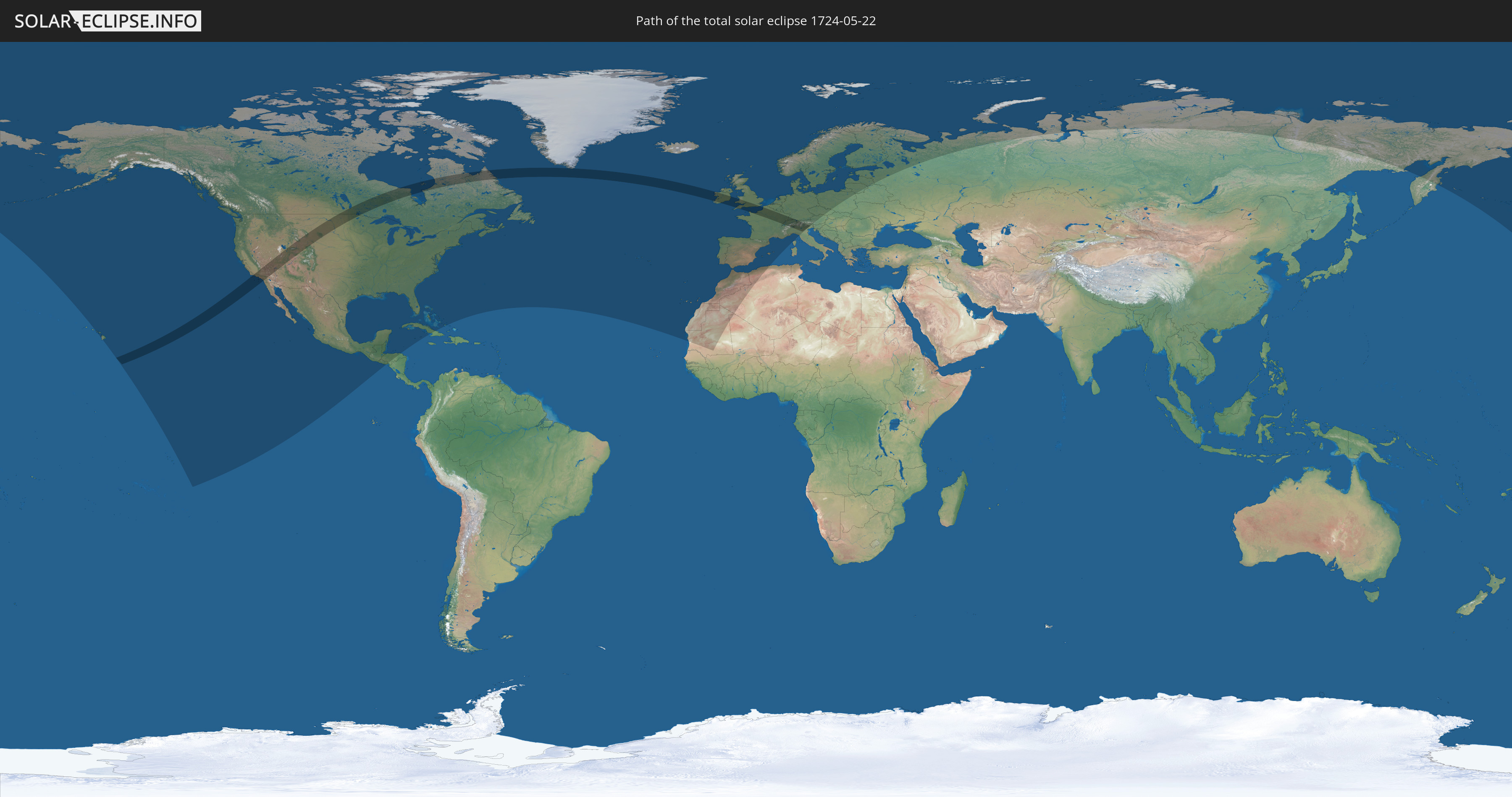
Die Sonnenfinsternis am 05/22/1724 kann man in 51 Ländern als partielle Sonnenfinsternis beobachten.
Der Finsternispfad verläuft durch 12 Länder. Nur in diesen Ländern ist sie als total Sonnenfinsternis zu sehen.
In den folgenden Ländern ist die Sonnenfinsternis total zu sehen
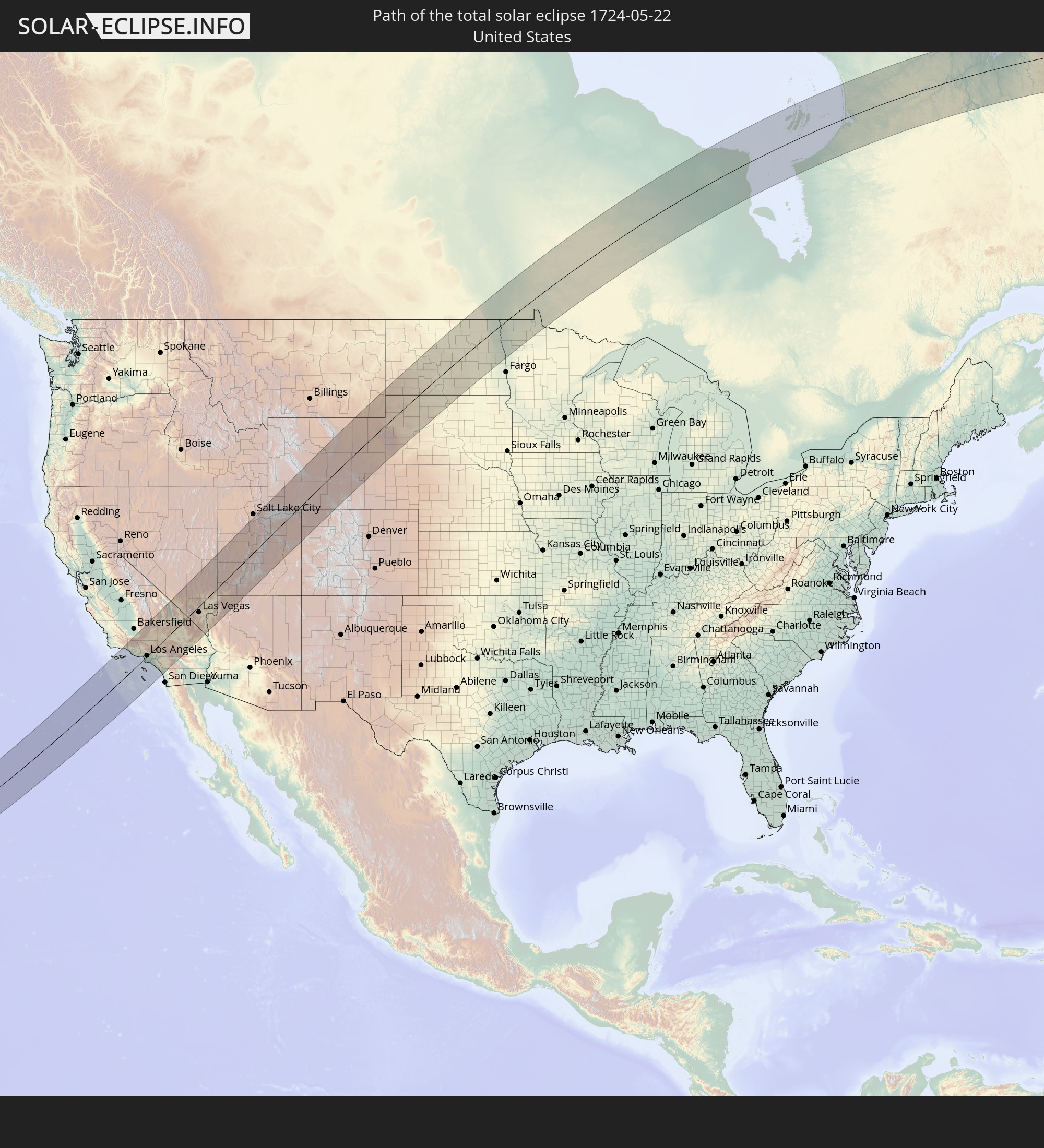 United States
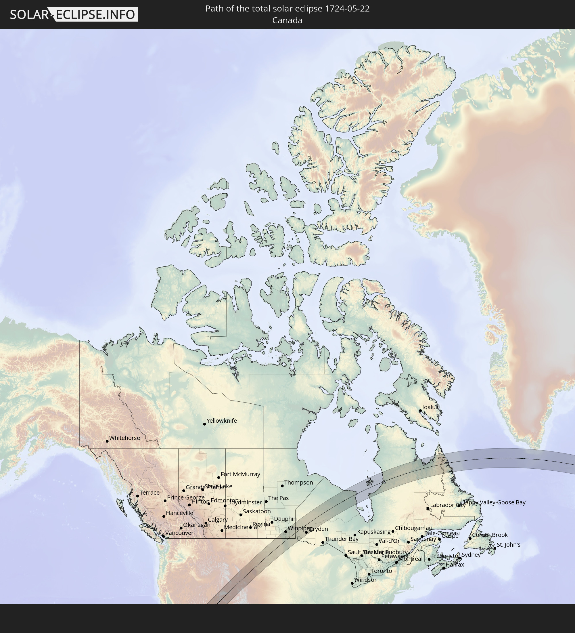 Canada
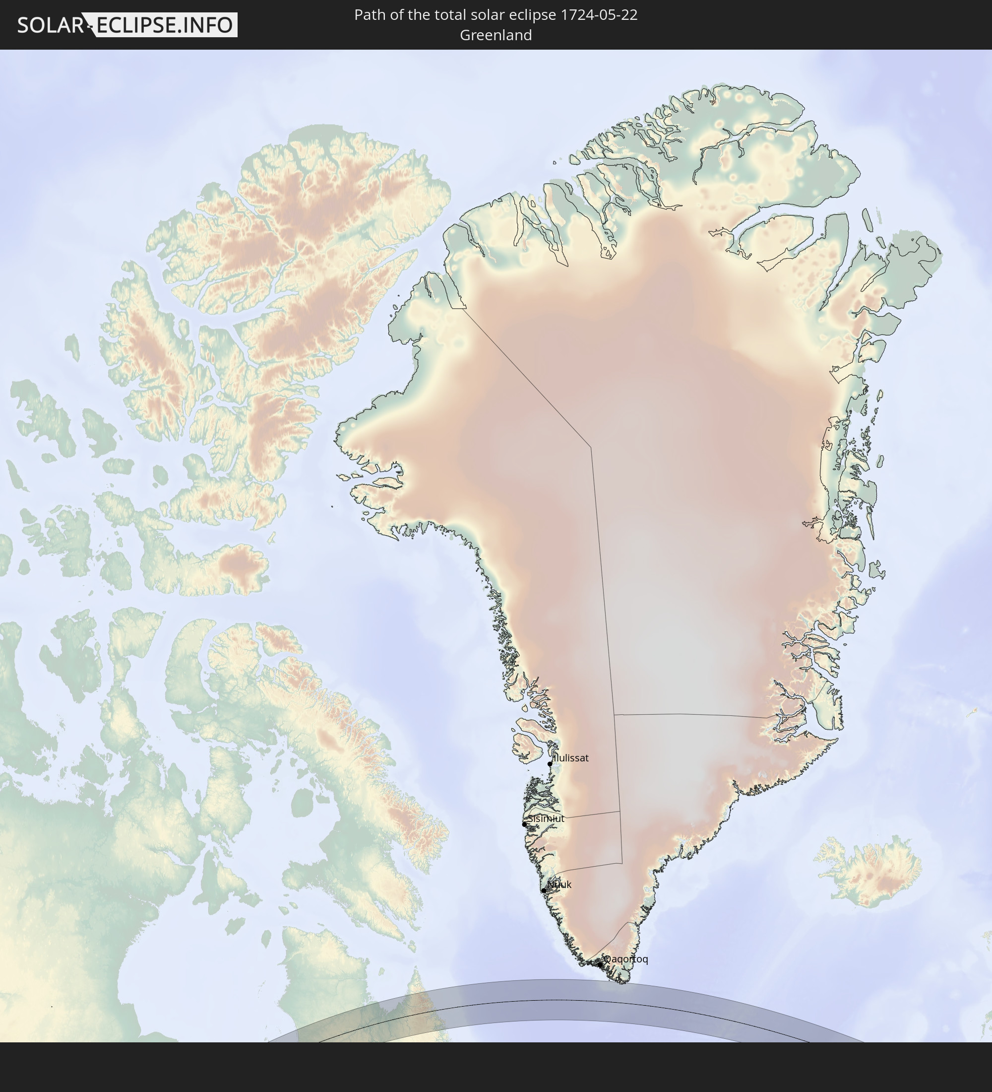 Greenland
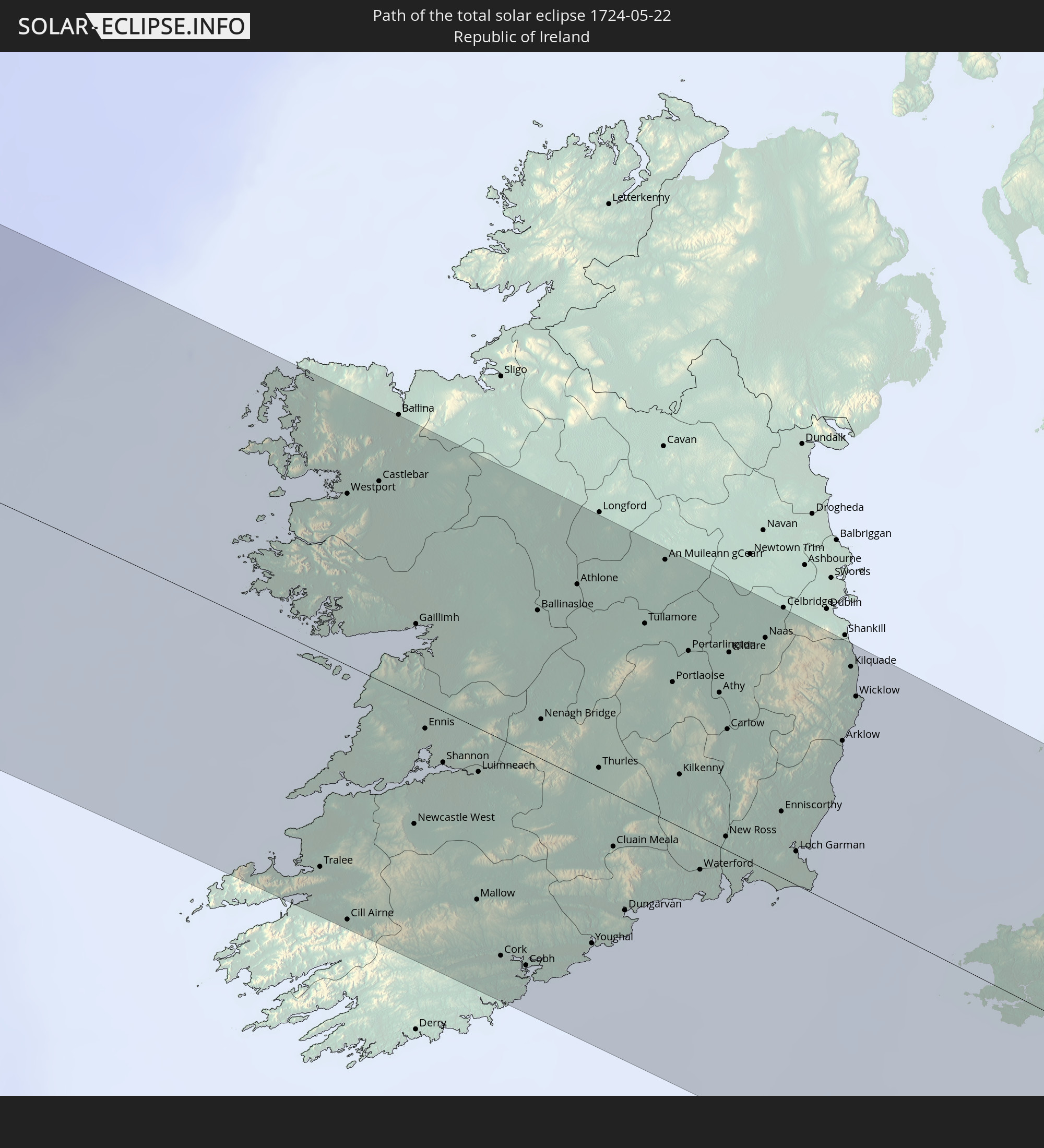 Republic of Ireland
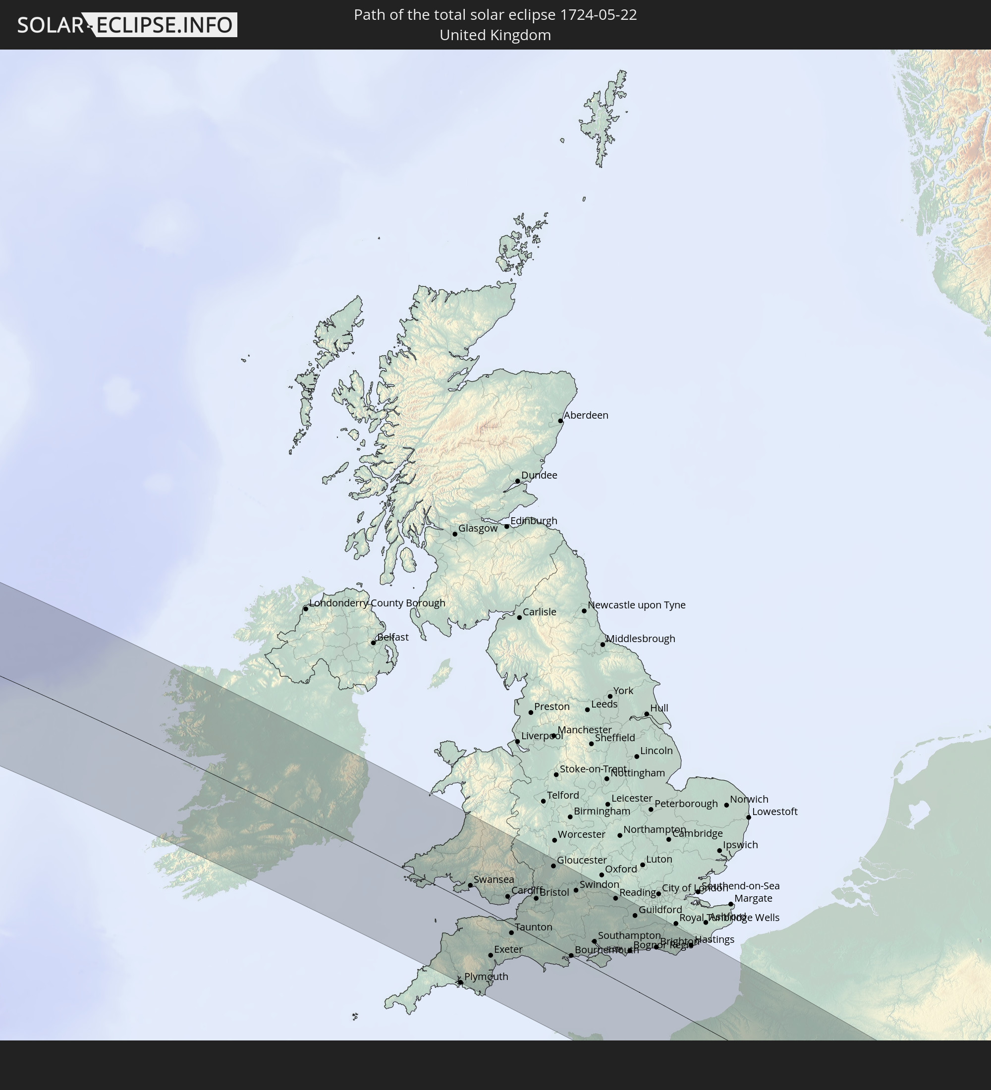 United Kingdom
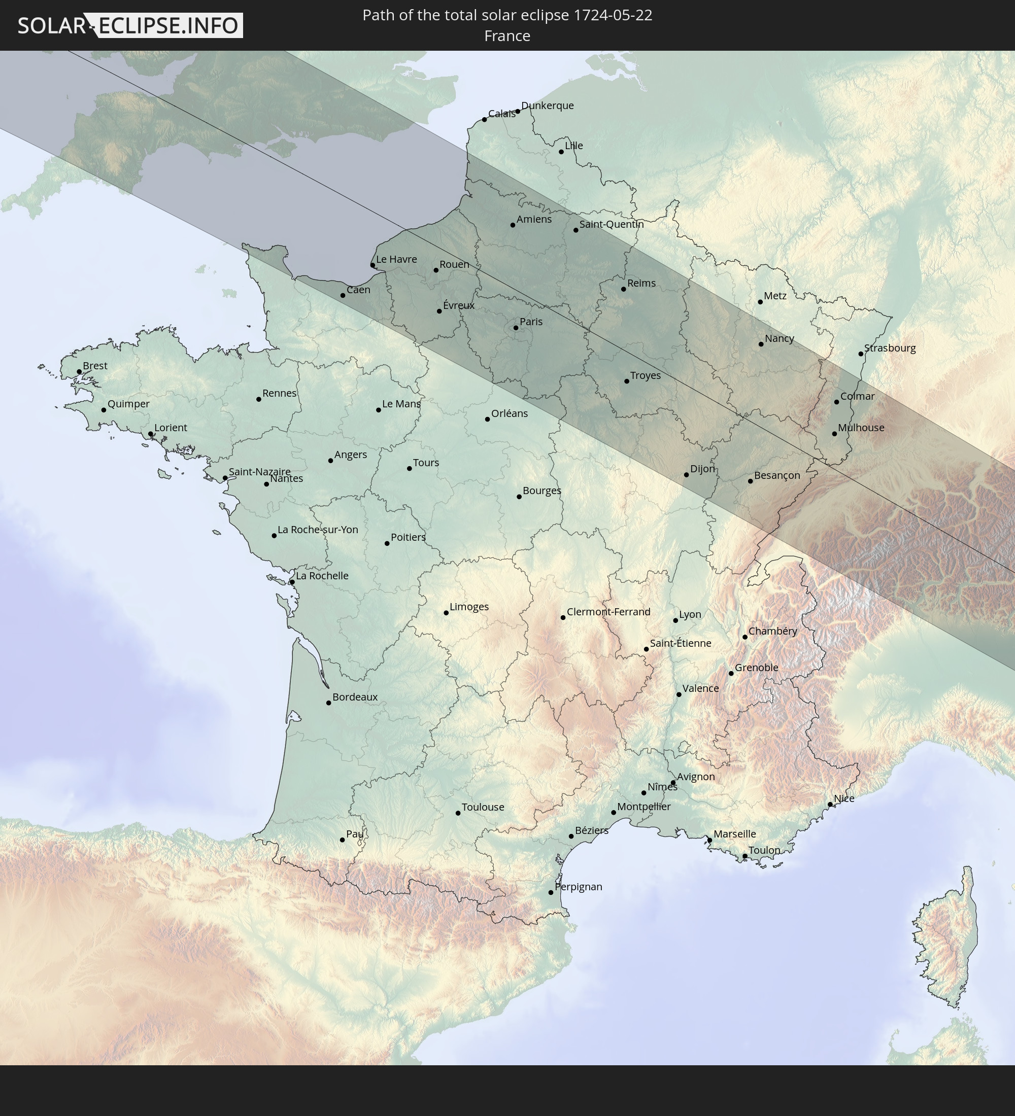 France
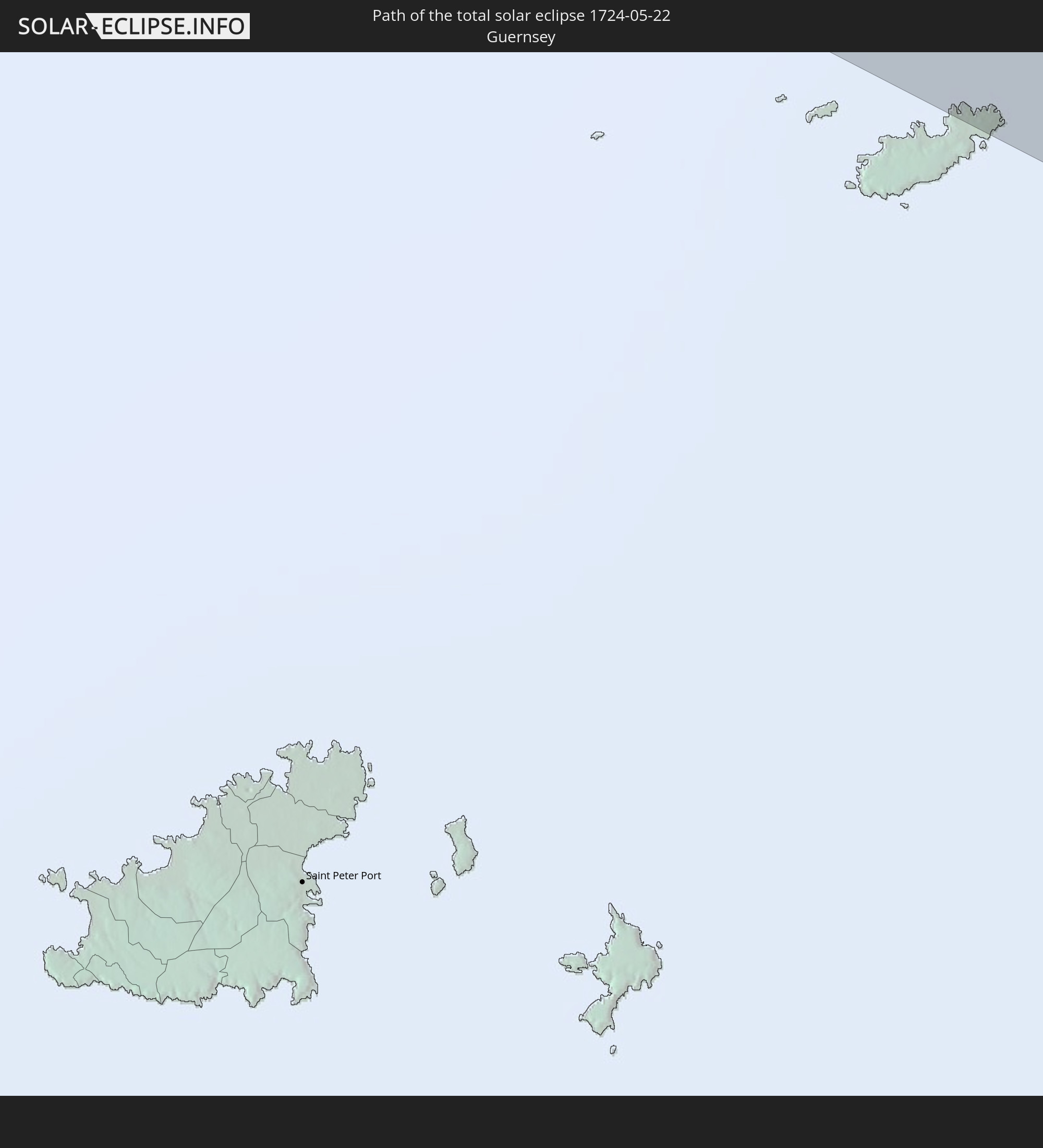 Guernsey
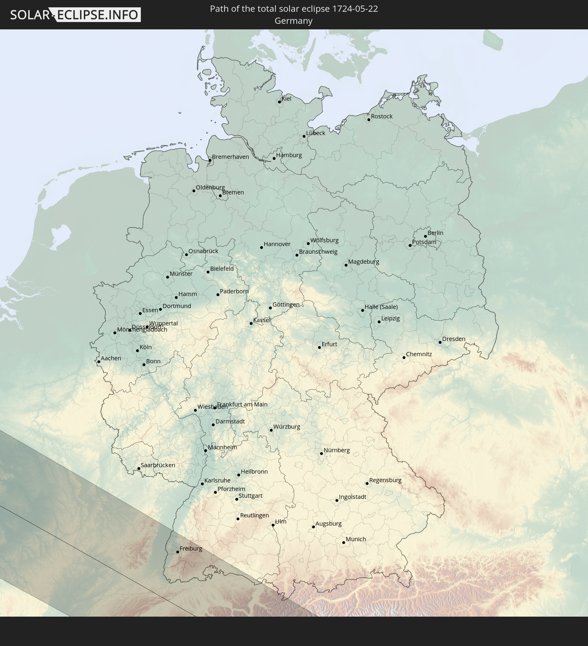 Germany
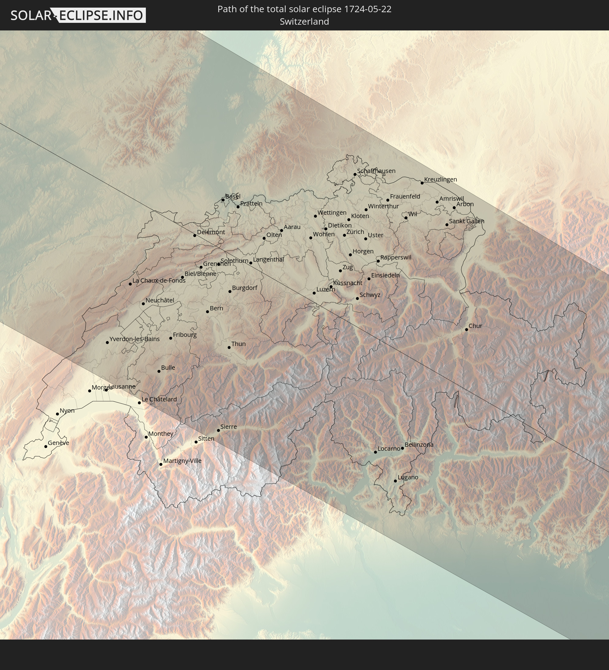 Switzerland
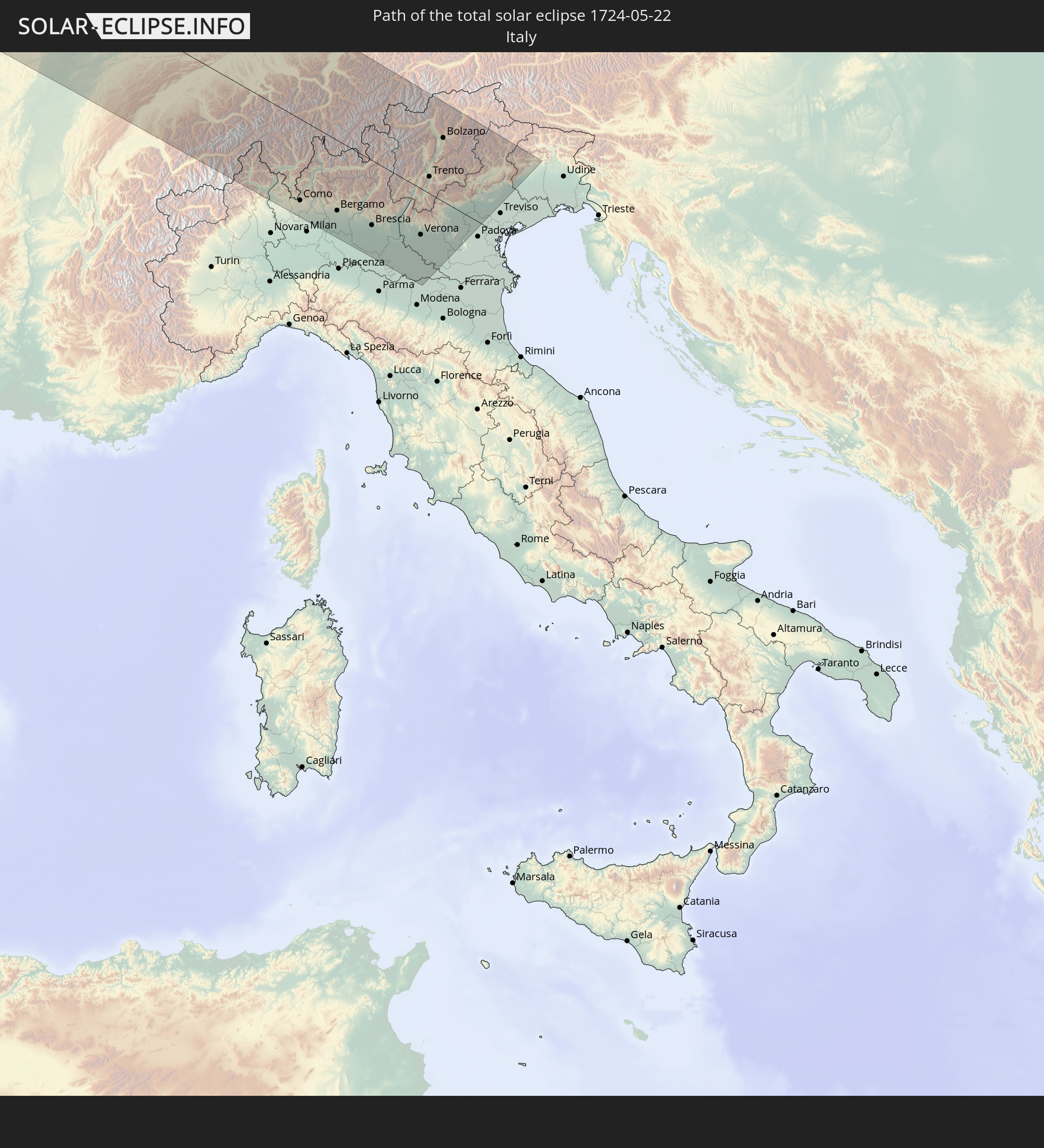 Italy
Italy
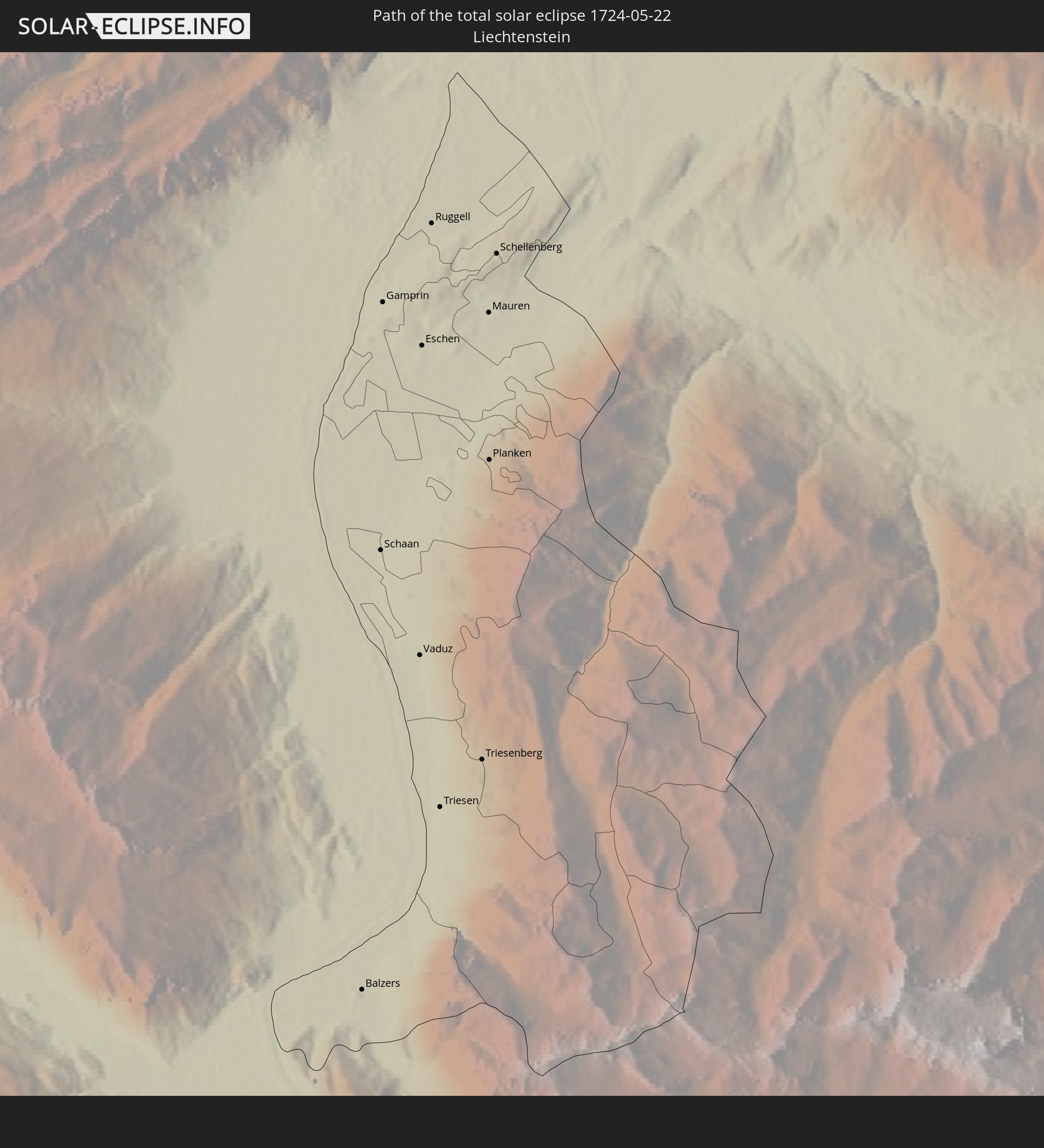 Liechtenstein
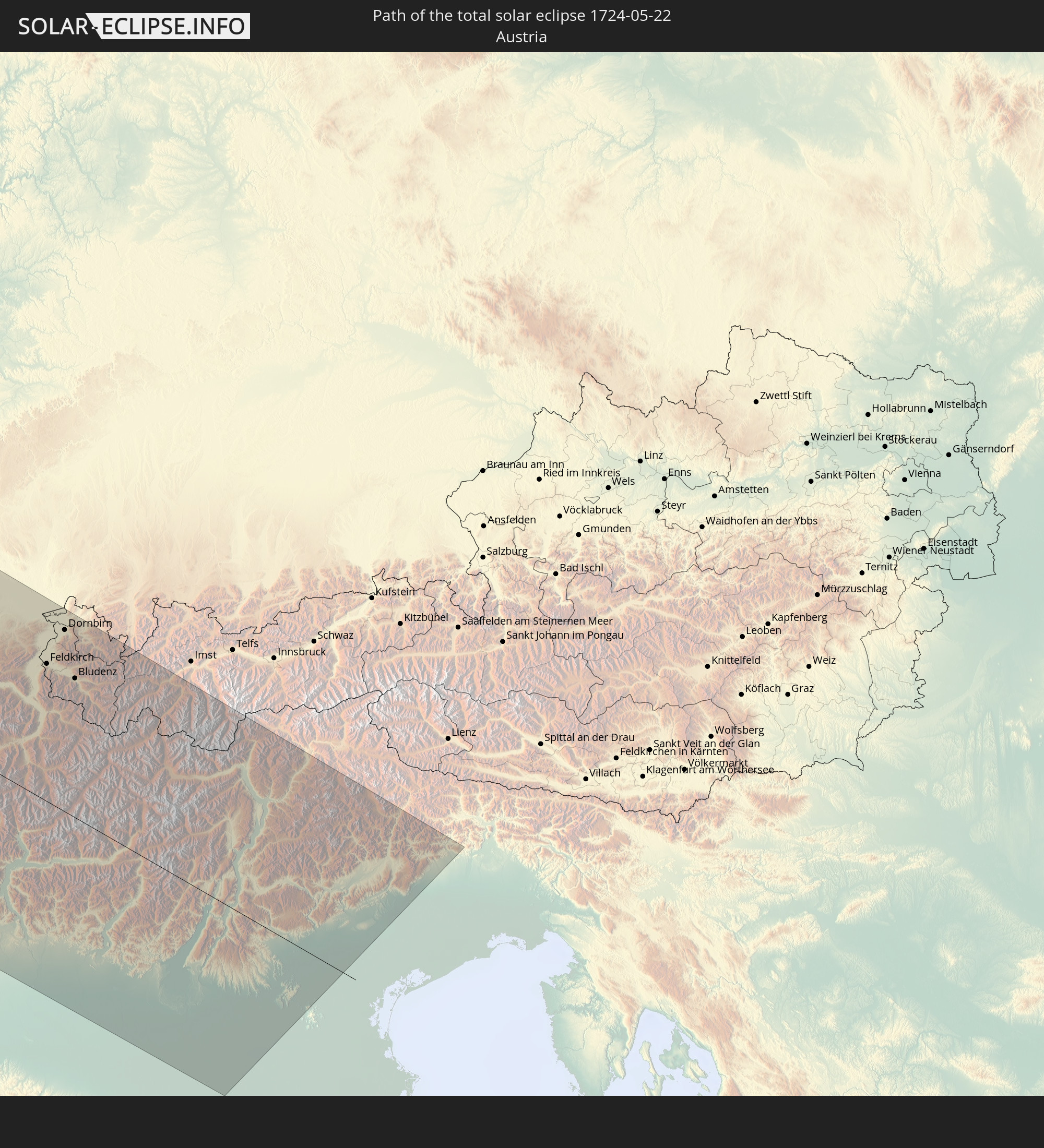 Austria
In den folgenden Ländern ist die Sonnenfinsternis partiell zu sehen
 Russia
 United States
 Canada
 Mexico
 Greenland
 Guatemala
 El Salvador
 Honduras
 Belize
 Cuba
Cuba
 Cayman Islands
 The Bahamas
 Bermuda
 Saint Pierre and Miquelon
 Portugal
 Iceland
 Spain
Spain
 Mauritania
 Morocco
 Mali
Mali
 Republic of Ireland
 Svalbard and Jan Mayen
 Algeria
 United Kingdom
 Faroe Islands
 Gibraltar
 France
 Isle of Man
 Guernsey
 Jersey
 Andorra
 Belgium
 Netherlands
 Norway
 Luxembourg
 Germany
 Switzerland
 Italy
Italy
 Monaco
 Denmark
 Liechtenstein
 Austria
 Sweden
 Czechia
 Poland
 Åland Islands
 Finland
 Lithuania
 Latvia
 Estonia
 Belarus
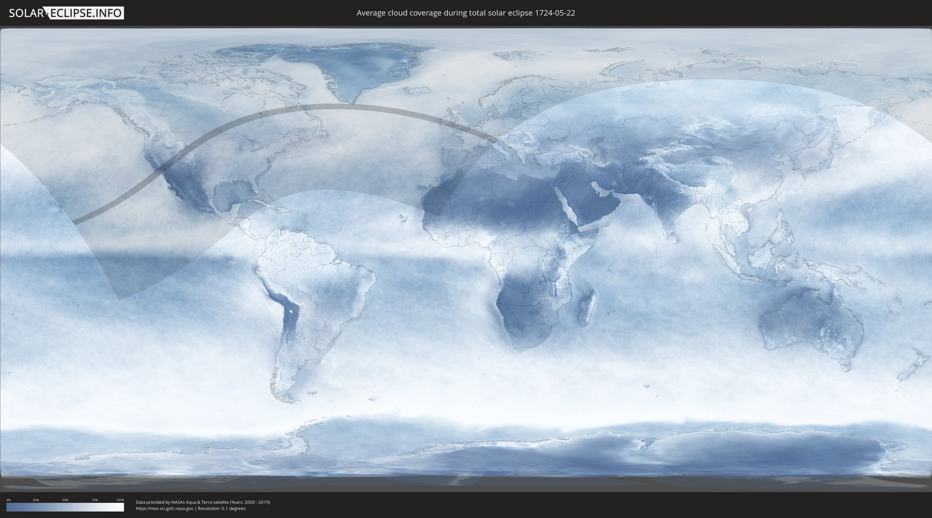
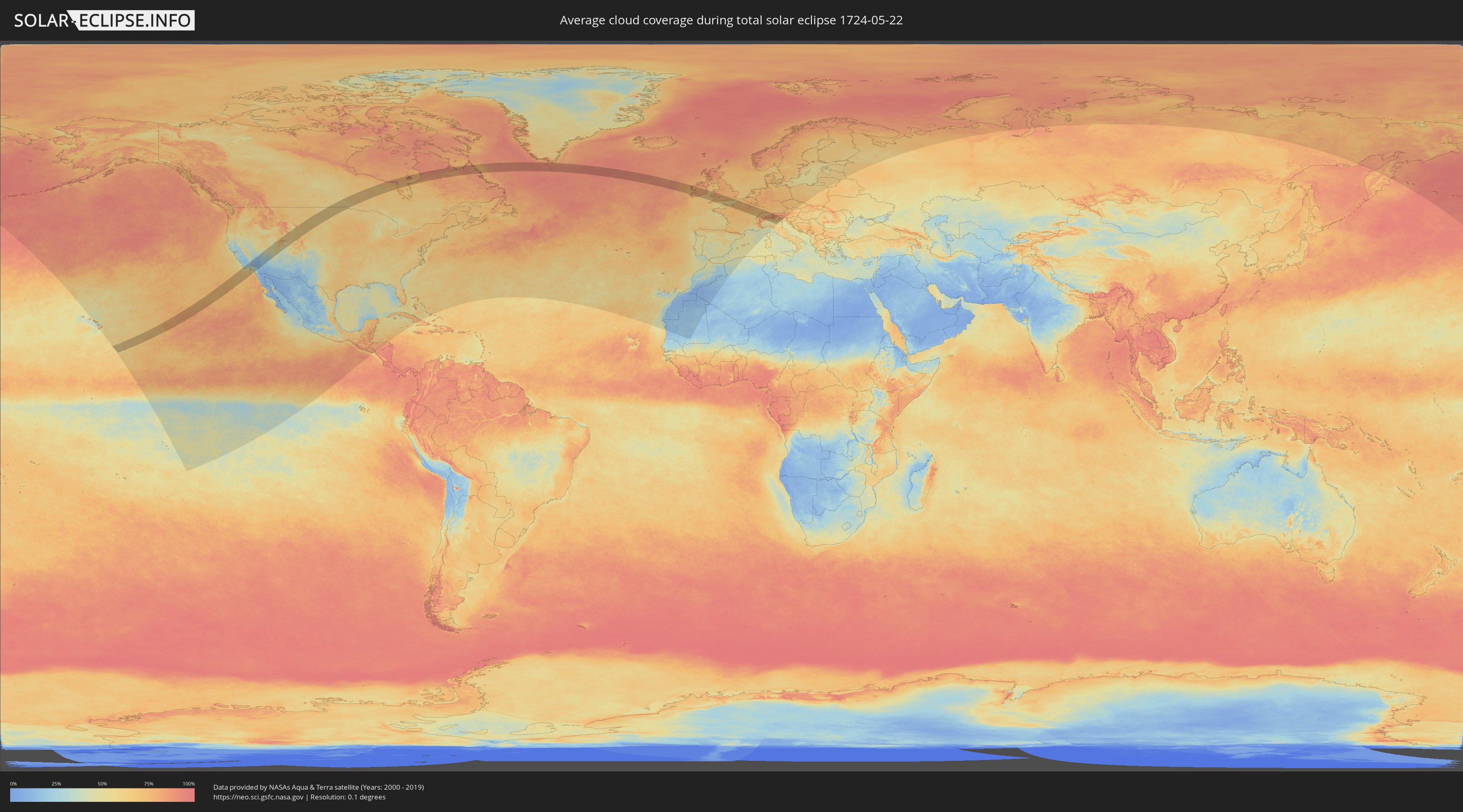
How will be the weather during the total solar eclipse on 05/22/1724?
Where is the best place to see the total solar eclipse of 05/22/1724?
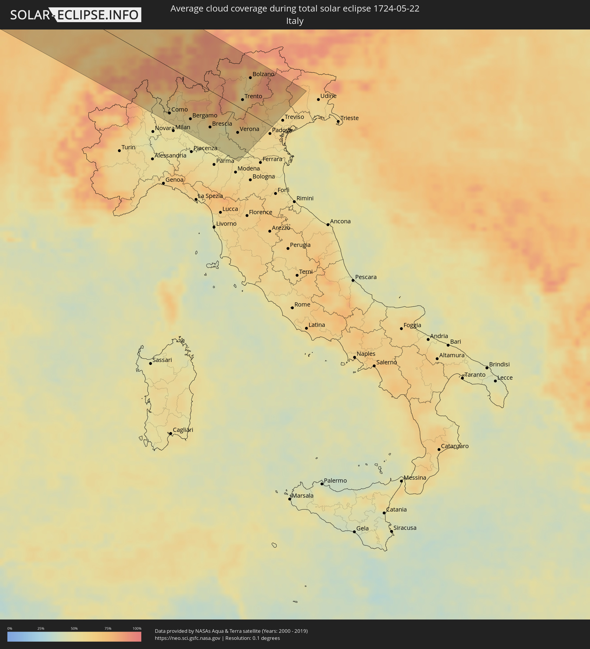
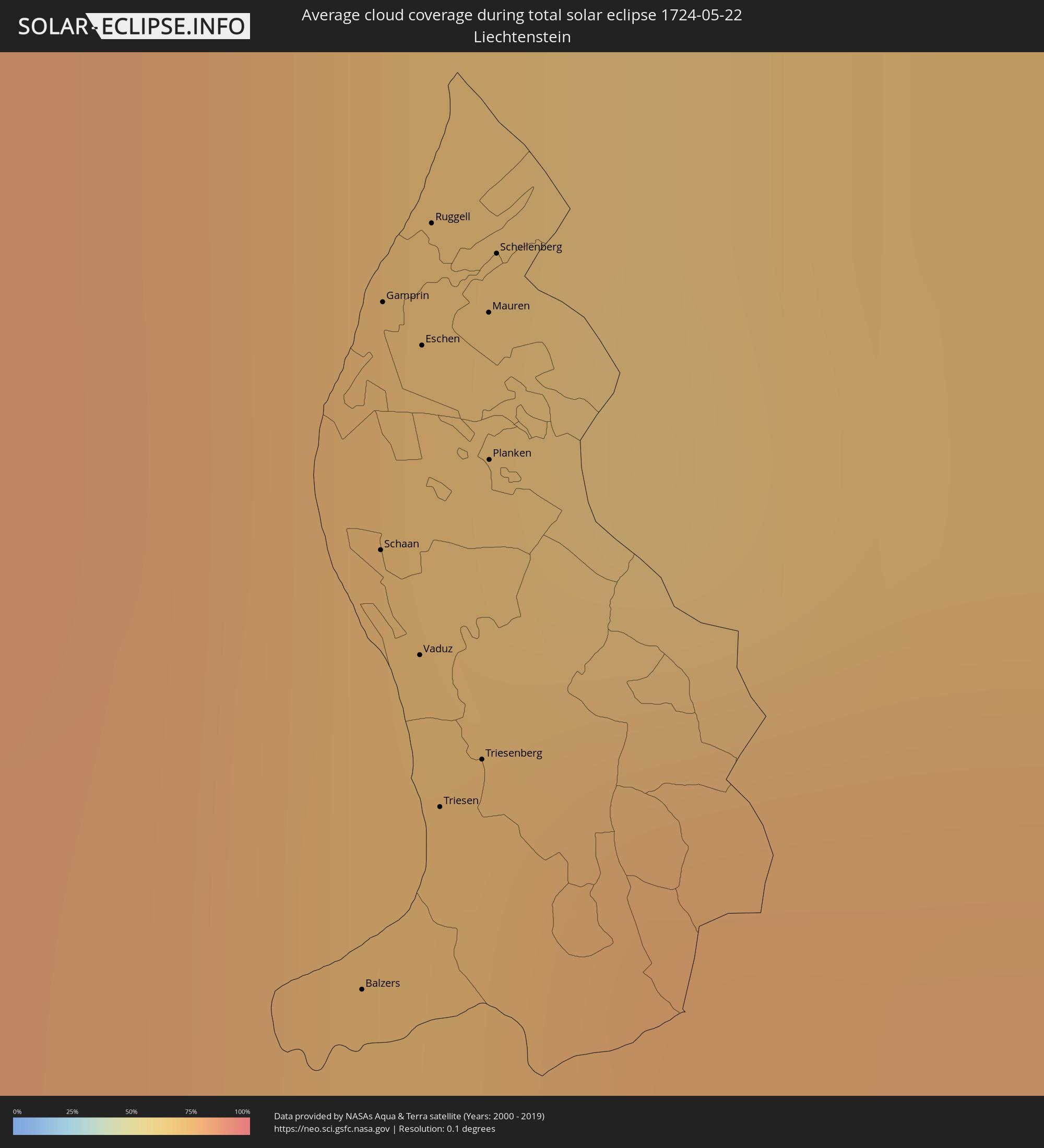
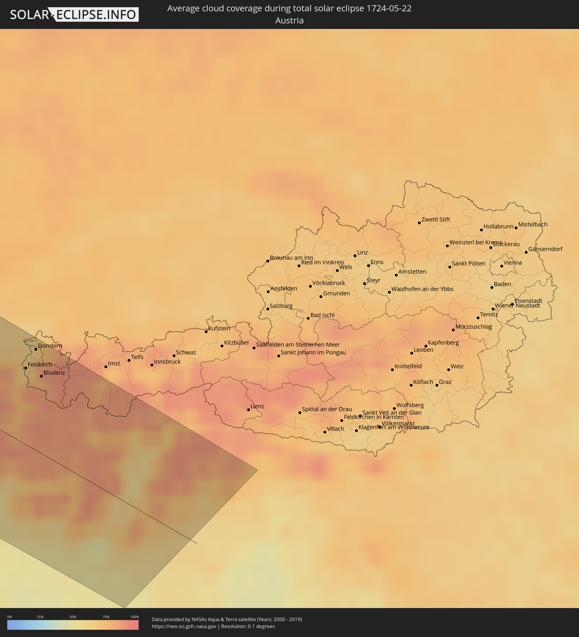
The following maps show the average cloud coverage for the day of the total solar eclipse.
With the help of these maps, it is possible to find the place along the eclipse path, which has the best
chance of a cloudless sky.
Nevertheless, you should consider local circumstances and inform about the weather of your chosen
observation site.
The data is provided by NASAs satellites
AQUA and TERRA.
The cloud maps are averaged over a period of 19 years (2000 - 2019).
Detailed country maps
 United States
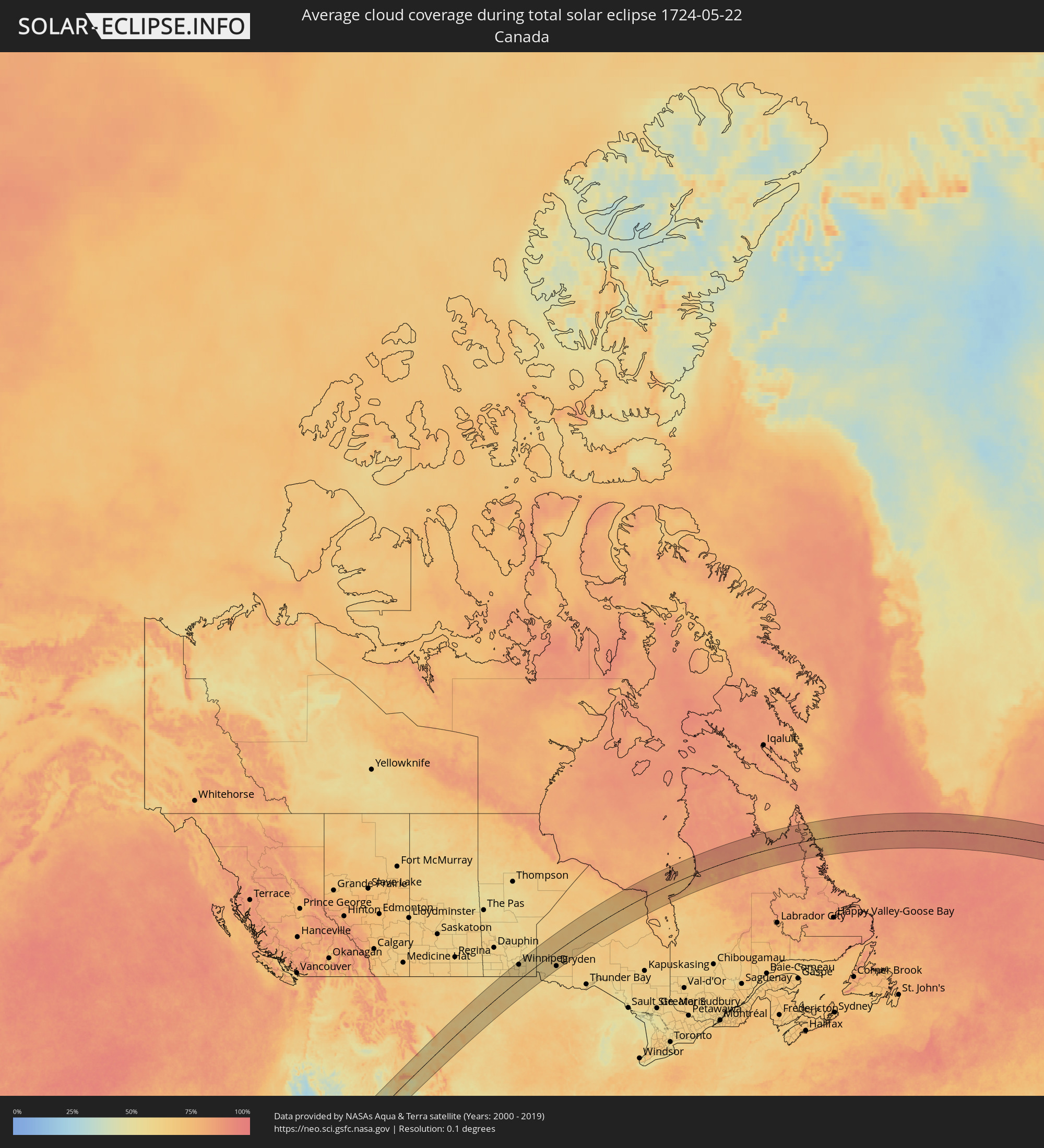 Canada
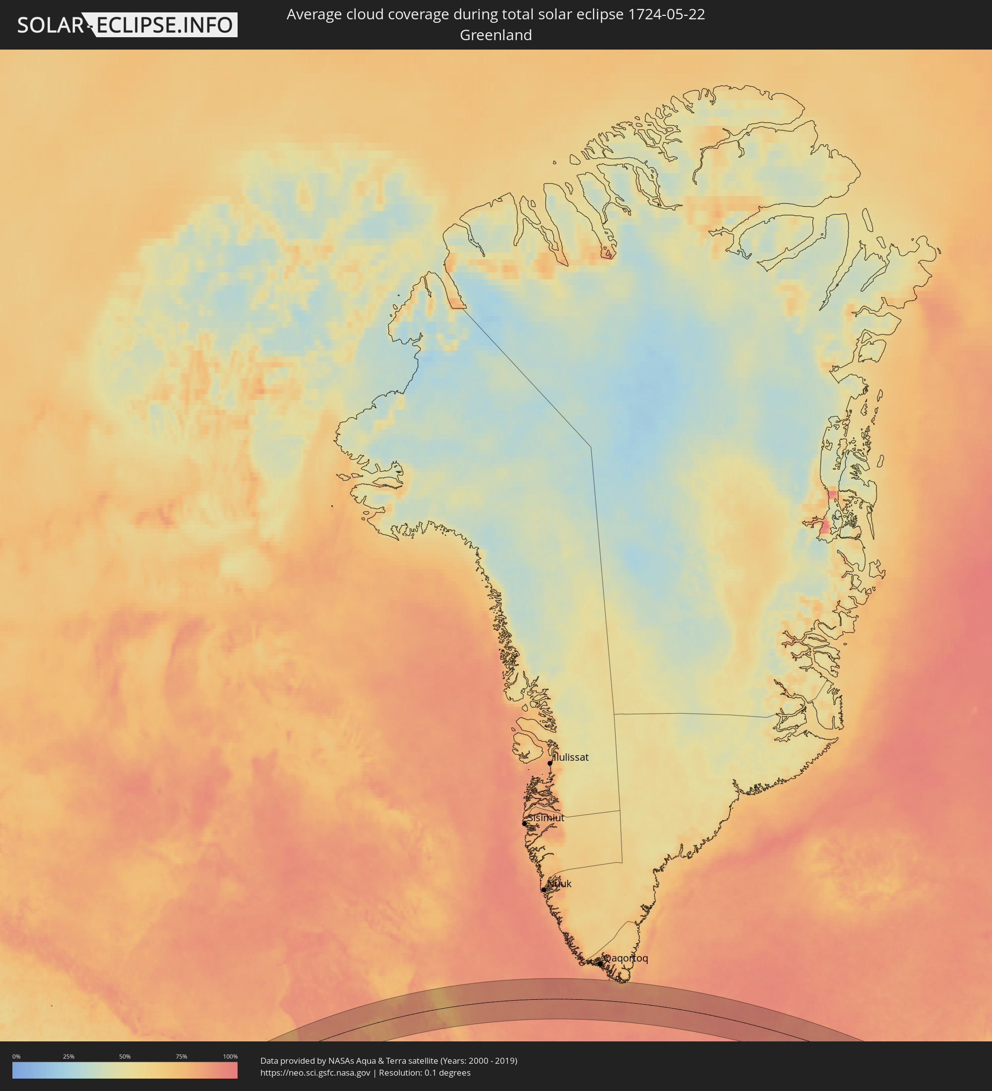 Greenland
 Republic of Ireland
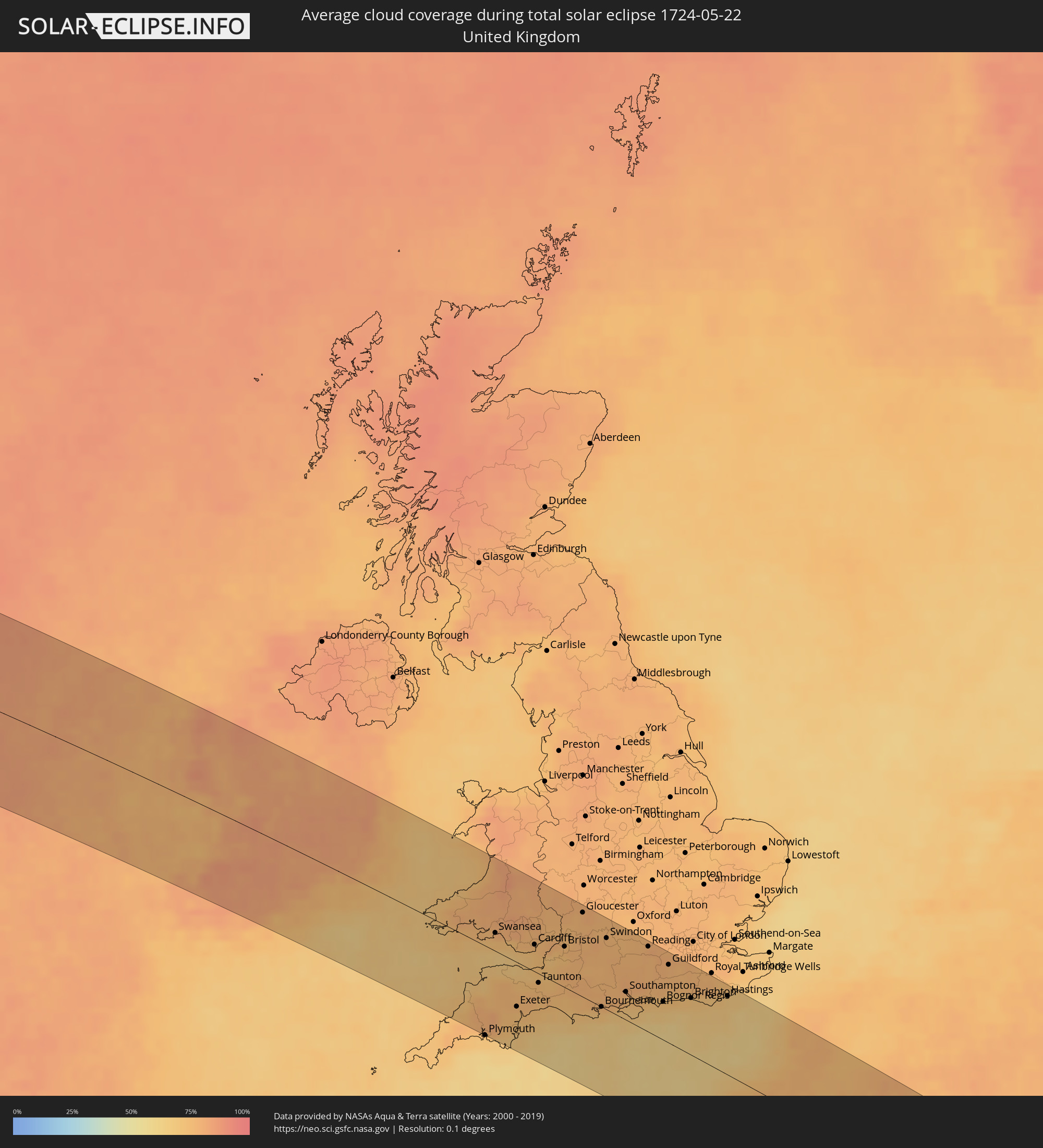 United Kingdom
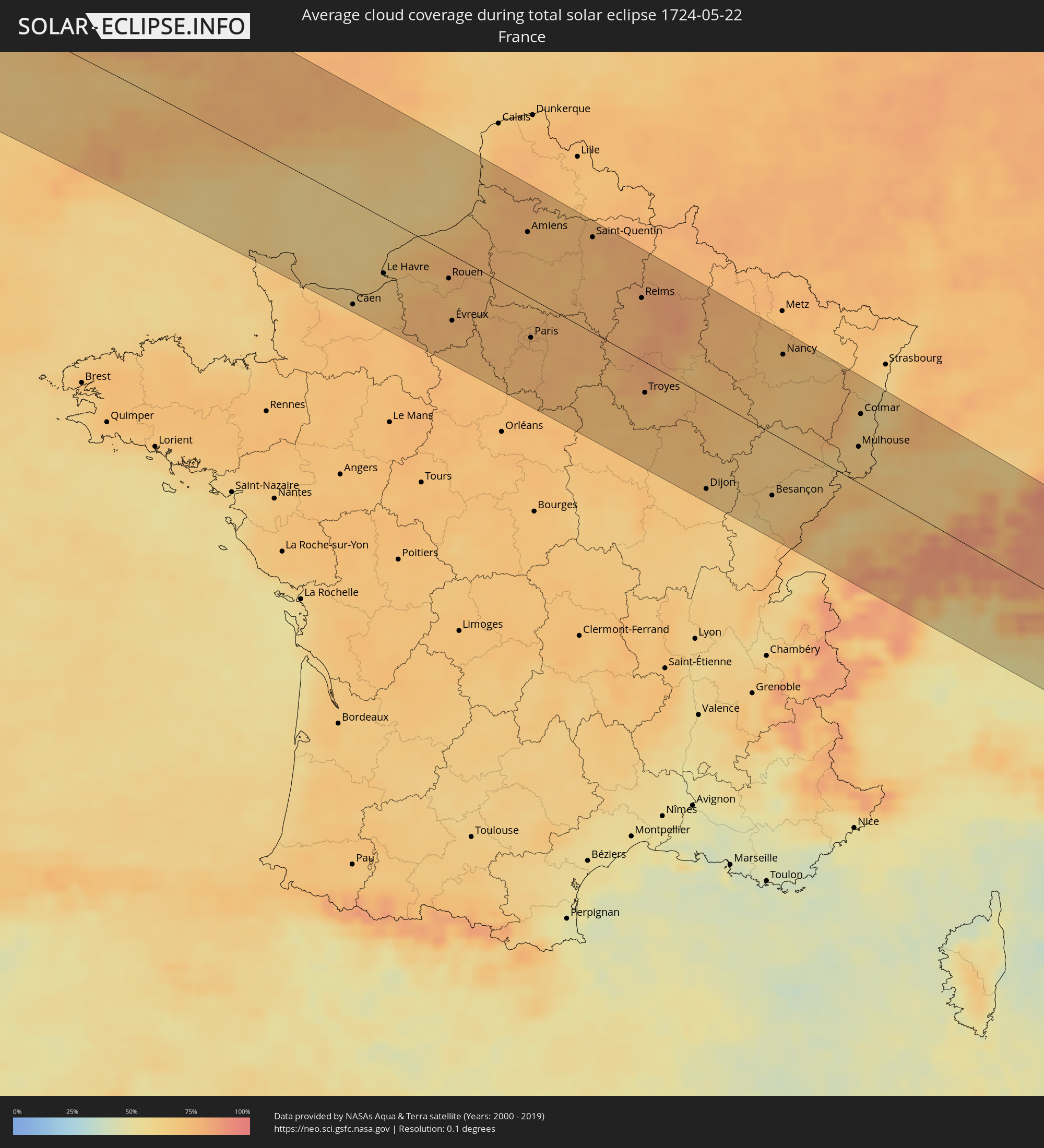 France
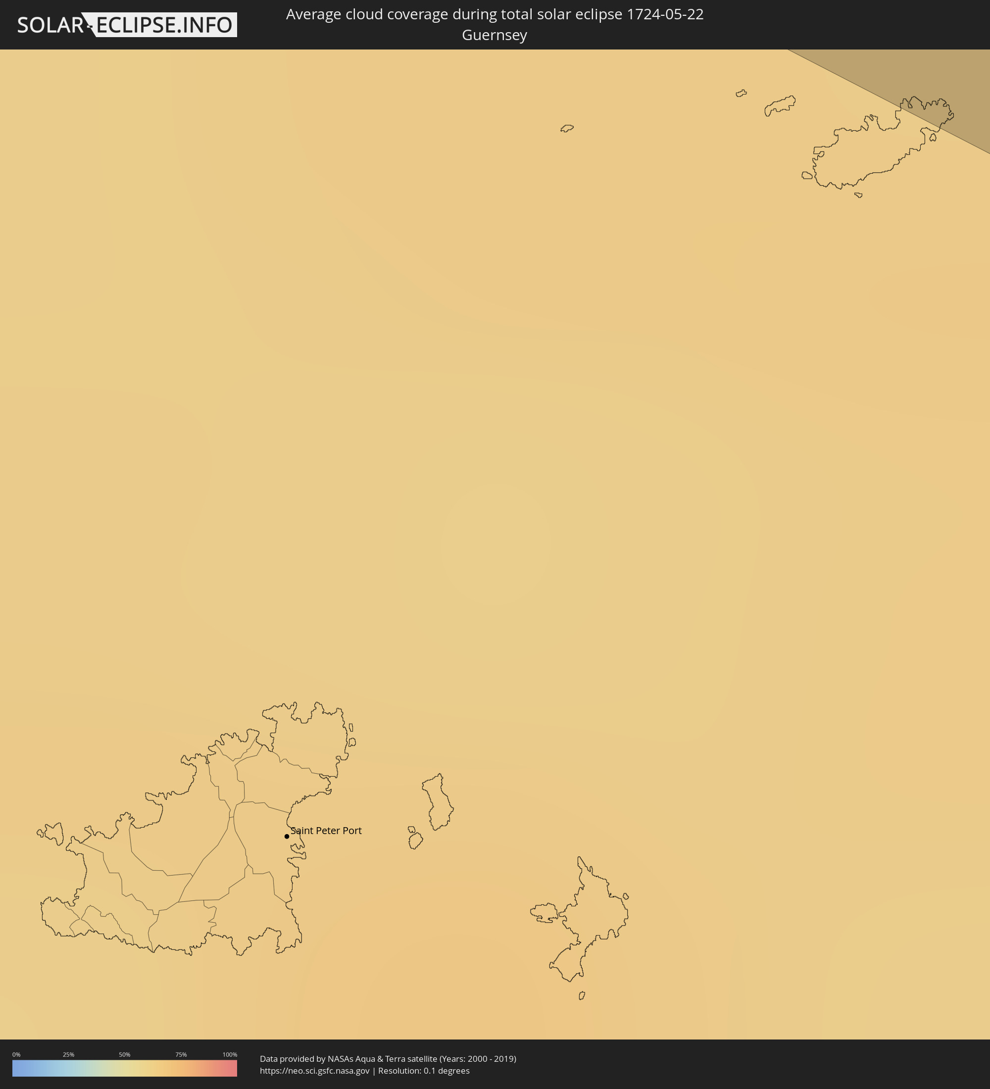 Guernsey
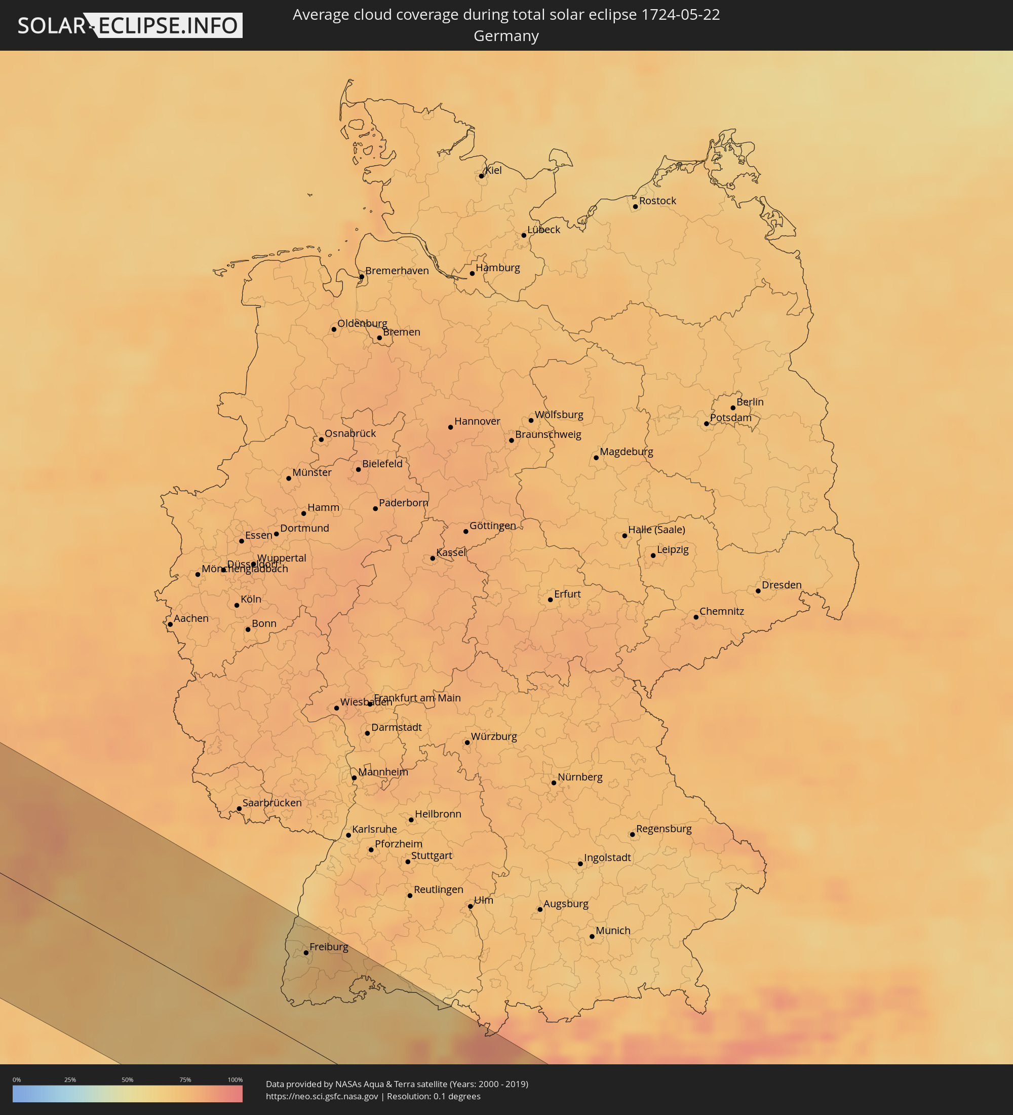 Germany
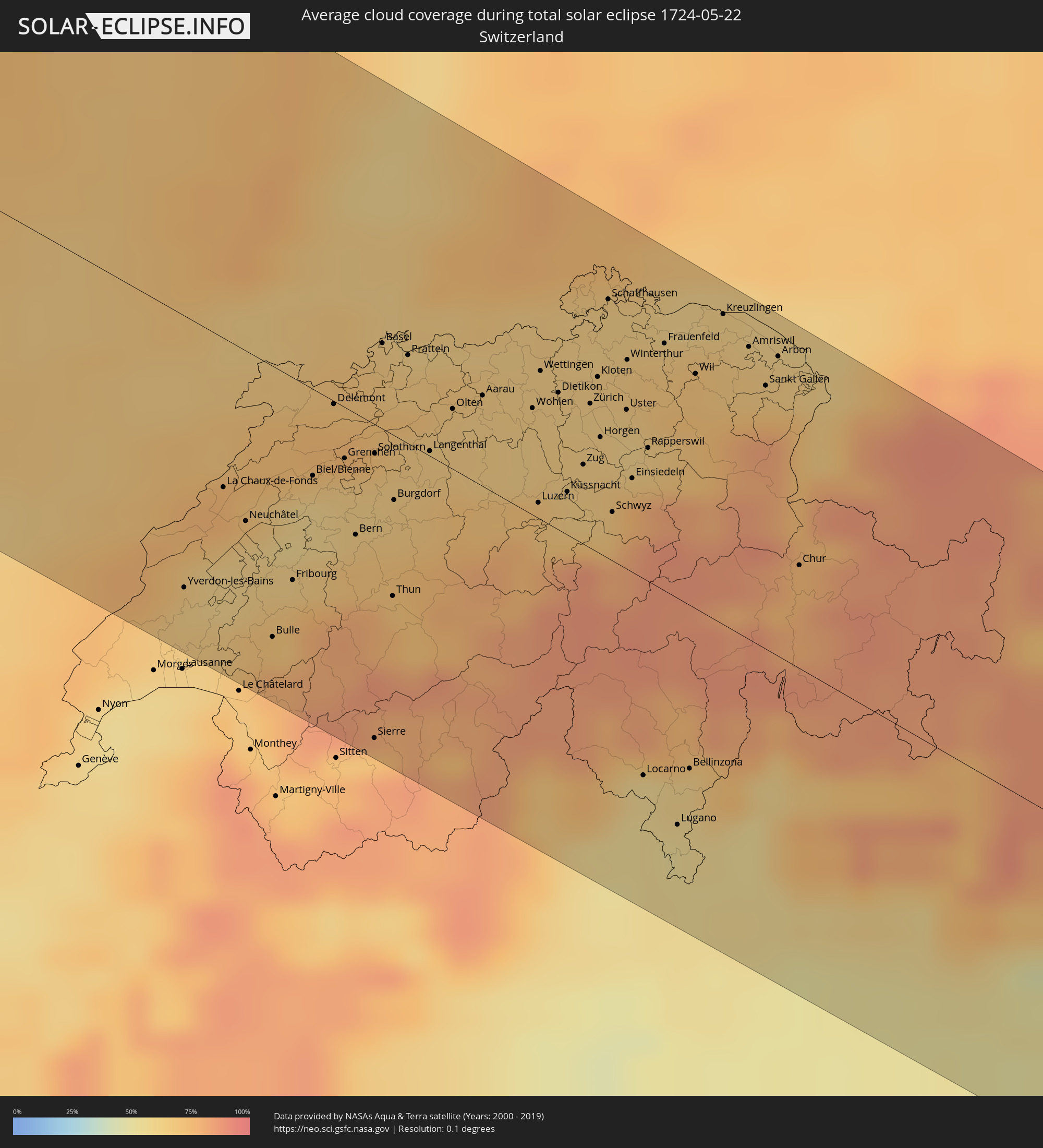 Switzerland
 Italy
Italy
 Liechtenstein
 Austria
Cities inside the path of the eclipse
The following table shows all locations with a population of more than 5,000 inside the eclipse path. Cities which have more than 100,000 inhabitants are marked bold. A click at the locations opens a detailed map.
| City | Type | Eclipse duration | Local time of max. eclipse | Distance to central line | Ø Cloud coverage |
|
Oxnard, California
|
total | - | 08:14:10 UTC-08:00 | 74 km | 46% |
|
Thousand Oaks, California
|
total | - | 08:14:21 UTC-08:00 | 50 km | 38% |
|
Santa Clarita, California
|
total | - | 08:14:56 UTC-08:00 | 54 km | 31% |
|
Van Nuys, California
|
total | - | 08:14:38 UTC-08:00 | 26 km | 38% |
|
Torrance, California
|
total | - | 08:14:05 UTC-08:00 | 9 km | 44% |
|
Los Angeles, California
|
total | - | 08:14:32 UTC-08:00 | 29 km | 42% |
|
Long Beach, California
|
total | - | 08:14:04 UTC-08:00 | 24 km | 45% |
|
Lancaster, California
|
total | - | 08:15:46 UTC-08:00 | 55 km | 14% |
|
Huntington Beach, California
|
total | - | 08:14:01 UTC-08:00 | 45 km | 45% |
|
Anaheim, California
|
total | - | 08:14:23 UTC-08:00 | 43 km | 40% |
|
Irvine, California
|
total | - | 08:14:09 UTC-08:00 | 63 km | 42% |
|
Pomona, California
|
total | - | 08:14:53 UTC-08:00 | 29 km | 44% |
|
Rancho Cucamonga, California
|
total | - | 08:15:05 UTC-08:00 | 39 km | 38% |
|
Corona, California
|
total | - | 08:14:42 UTC-08:00 | 55 km | 38% |
|
Riverside, California
|
total | - | 08:14:57 UTC-08:00 | 63 km | 34% |
|
Oceanside, California
|
total | - | 08:13:37 UTC-08:00 | 122 km | 57% |
|
San Bernardino, California
|
total | - | 08:15:19 UTC-08:00 | 59 km | 34% |
|
Moreno Valley, California
|
total | - | 08:15:03 UTC-08:00 | 77 km | 31% |
|
Las Vegas, Nevada
|
total | - | 08:20:41 UTC-08:00 | 33 km | 23% |
|
Henderson, Nevada
|
total | - | 08:20:33 UTC-08:00 | 49 km | 24% |
|
Morden, Manitoba
|
total | - | 11:01:11 UTC-06:00 | 84 km | 63% |
|
Winkler, Manitoba
|
total | - | 11:01:22 UTC-06:00 | 77 km | 61% |
|
Winnipeg, Manitoba
|
total | - | 11:03:22 UTC-06:00 | 101 km | 61% |
|
Selkirk, Manitoba
|
total | - | 11:04:04 UTC-06:00 | 110 km | 58% |
|
Steinbach, Manitoba
|
total | - | 11:03:25 UTC-06:00 | 52 km | 59% |
|
Dryden, Ontario
|
total | - | 11:08:47 UTC-06:00 | 101 km | 60% |
|
Tralee, Munster
|
total | - | 18:08:12 UTC-00:25 | 90 km | 82% |
|
Castlebar, Connaught
|
total | - | 18:06:17 UTC-00:25 | 82 km | 81% |
|
Gaillimh, Connaught
|
total | - | 18:07:02 UTC-00:25 | 35 km | 78% |
|
Ennis, Munster
|
total | - | 18:07:34 UTC-00:25 | 12 km | 81% |
|
Luimneach, Munster
|
total | - | 18:07:49 UTC-00:25 | 18 km | 83% |
|
Cork, Munster
|
total | - | 18:08:45 UTC-00:25 | 91 km | 80% |
|
Athlone, Leinster
|
total | - | 18:06:54 UTC-00:25 | 79 km | 81% |
|
Cluain Meala, Munster
|
total | - | 18:08:15 UTC-00:25 | 22 km | 81% |
|
Tullamore, Leinster
|
total | - | 18:07:08 UTC-00:25 | 76 km | 82% |
|
An Muileann gCearr, Leinster
|
total | - | 18:06:49 UTC-00:25 | 106 km | 78% |
|
Portlaoise, Leinster
|
total | - | 18:07:26 UTC-00:25 | 60 km | 83% |
|
Kilkenny, Leinster
|
total | - | 18:07:54 UTC-00:25 | 23 km | 83% |
|
Waterford, Munster
|
total | - | 18:08:23 UTC-00:25 | 14 km | 75% |
|
Athy, Leinster
|
total | - | 18:07:30 UTC-00:25 | 64 km | 83% |
|
Carlow, Leinster
|
total | - | 18:07:41 UTC-00:25 | 53 km | 82% |
|
Naas, Leinster
|
total | - | 18:07:14 UTC-00:25 | 96 km | 83% |
|
Loch Garman, Leinster
|
total | - | 18:08:19 UTC-00:25 | 14 km | 72% |
|
Jobstown
|
total | - | 18:07:10 UTC-00:25 | 110 km | 83% |
|
Arklow, Leinster
|
total | - | 18:07:46 UTC-00:25 | 70 km | 76% |
|
Kilquade
|
total | - | 18:07:23 UTC-00:25 | 103 km | 75% |
|
Plymouth, England
|
total | - | 18:35:59 UTC+00:00 | 109 km | 69% |
|
Swansea, Wales
|
total | - | 18:34:30 UTC+00:00 | 23 km | 73% |
|
Exeter, England
|
total | - | 18:35:33 UTC+00:00 | 55 km | 73% |
|
Cardiff, Wales
|
total | - | 18:34:39 UTC+00:00 | 33 km | 74% |
|
Newport, Wales
|
total | - | 18:34:30 UTC+00:00 | 51 km | 76% |
|
Mendip, England
|
total | - | 18:34:54 UTC+00:00 | 31 km | 78% |
|
Bristol, England
|
total | - | 18:34:38 UTC+00:00 | 49 km | 76% |
|
Bath, England
|
total | - | 18:34:43 UTC+00:00 | 51 km | 77% |
|
Gloucester, England
|
total | - | 18:34:08 UTC+00:00 | 101 km | 78% |
|
Bournemouth, England
|
total | - | 18:35:27 UTC+00:00 | 10 km | 72% |
|
Swindon, England
|
total | - | 18:34:28 UTC+00:00 | 86 km | 76% |
|
Southampton, England
|
total | - | 18:35:12 UTC+00:00 | 35 km | 74% |
|
Portsmouth, England
|
total | - | 18:35:17 UTC+00:00 | 37 km | 71% |
|
Basingstoke, England
|
total | - | 18:34:45 UTC+00:00 | 80 km | 78% |
|
Reading, England
|
total | - | 18:34:31 UTC+00:00 | 103 km | 78% |
|
Woking, England
|
total | - | 18:34:38 UTC+00:00 | 104 km | 77% |
|
Worthing, England
|
total | - | 18:35:12 UTC+00:00 | 62 km | 69% |
|
Caen, Normandy
|
total | - | 18:46:23 UTC+00:09 | 101 km | 70% |
|
Crawley, England
|
total | - | 18:34:50 UTC+00:00 | 96 km | 76% |
|
Brighton, England
|
total | - | 18:35:10 UTC+00:00 | 69 km | 69% |
|
Le Havre, Normandy
|
total | - | 18:45:59 UTC+00:09 | 54 km | 67% |
|
Eastbourne, England
|
total | - | 18:35:11 UTC+00:00 | 80 km | 67% |
|
Rouen, Normandy
|
total | - | 18:45:54 UTC+00:09 | 31 km | 74% |
|
Évreux, Normandy
|
total | - | 18:46:21 UTC+00:09 | 64 km | 76% |
|
Saint-Quentin-en-Yvelines, Île-de-France
|
total | - | 18:46:30 UTC+00:09 | 58 km | 74% |
|
Cergy-Pontoise, Île-de-France
|
total | - | 18:46:12 UTC+00:09 | 35 km | 76% |
|
Amiens, Hauts-de-France
|
total | - | 18:45:13 UTC+00:09 | 63 km | 74% |
|
Paris, Île-de-France
|
total | - | 18:46:21 UTC+00:09 | 39 km | 76% |
|
Sarcelles, Île-de-France
|
total | - | 18:46:11 UTC+00:09 | 23 km | 76% |
|
Noisy-le-Grand, Île-de-France
|
total | - | 18:46:19 UTC+00:09 | 37 km | 76% |
|
Meaux, Île-de-France
|
total | - | 18:46:09 UTC+00:09 | 10 km | 76% |
|
Saint-Quentin, Hauts-de-France
|
total | - | 18:45:06 UTC+00:09 | 93 km | 75% |
|
Reims, Grand-Est
|
total | - | 18:45:37 UTC+00:09 | 61 km | 79% |
|
Troyes, Grand-Est
|
total | - | 18:46:37 UTC+00:09 | 35 km | 76% |
|
Dijon, Bourgogne-Franche-Comté
|
total | - | 18:47:25 UTC+00:09 | 92 km | 70% |
|
Besançon, Bourgogne-Franche-Comté
|
total | - | 18:47:15 UTC+00:09 | 62 km | 65% |
|
Nancy, Grand-Est
|
total | - | 18:45:44 UTC+00:09 | 84 km | 73% |
|
Yverdon-les-Bains, Vaud
|
total | - | 19:38:12 UTC+01:00 | 86 km | 64% |
|
La Chaux-de-Fonds, Neuchâtel
|
total | - | 19:37:50 UTC+01:00 | 47 km | 75% |
|
Belfort, Bourgogne-Franche-Comté
|
total | - | 18:46:38 UTC+00:09 | 17 km | 64% |
|
Fribourg, Fribourg
|
total | - | 19:38:03 UTC+01:00 | 63 km | 74% |
|
Biel/Bienne, Bern
|
total | - | 19:37:41 UTC+01:00 | 28 km | 60% |
|
Mulhouse, Grand-Est
|
total | - | 18:46:24 UTC+00:09 | 37 km | 64% |
|
Colmar, Grand-Est
|
total | - | 18:46:03 UTC+00:09 | 70 km | 61% |
|
Bern, Bern
|
total | - | 19:37:49 UTC+01:00 | 41 km | 70% |
|
Basel, Basel-City
|
total | - | 19:37:10 UTC+01:00 | 28 km | 65% |
|
Breisach am Rhein, Baden-Württemberg
|
total | - | 19:36:42 UTC+01:00 | 73 km | 63% |
|
Thun, Bern
|
total | - | 19:37:58 UTC+01:00 | 50 km | 70% |
|
Müllheim, Baden-Württemberg
|
total | - | 19:36:54 UTC+01:00 | 56 km | 63% |
|
Ihringen, Baden-Württemberg
|
total | - | 19:36:40 UTC+01:00 | 77 km | 63% |
|
Lörrach, Baden-Württemberg
|
total | - | 19:37:06 UTC+01:00 | 36 km | 62% |
|
Schallstadt, Baden-Württemberg
|
total | - | 19:36:43 UTC+01:00 | 74 km | 67% |
|
Ettenheim, Baden-Württemberg
|
total | - | 19:36:24 UTC+01:00 | 103 km | 64% |
|
Freiburg, Baden-Württemberg
|
total | - | 19:36:39 UTC+01:00 | 80 km | 71% |
|
Zell im Wiesental, Baden-Württemberg
|
total | - | 19:36:57 UTC+01:00 | 51 km | 65% |
|
Bad Säckingen, Baden-Württemberg
|
total | - | 19:37:04 UTC+01:00 | 43 km | 63% |
|
Elzach, Baden-Württemberg
|
total | - | 19:36:25 UTC+01:00 | 105 km | 72% |
|
Titisee-Neustadt, Baden-Württemberg
|
total | - | 19:36:38 UTC+01:00 | 85 km | 76% |
|
Waldshut-Tiengen, Baden-Württemberg
|
total | - | 19:36:56 UTC+01:00 | 58 km | 64% |
|
Luzern, Lucerne
|
total | - | 19:37:28 UTC+01:00 | 20 km | 70% |
|
Wettingen, Aargau
|
total | - | 19:37:03 UTC+01:00 | 46 km | 64% |
|
Bonndorf im Schwarzwald, Baden-Württemberg
|
total | - | 19:36:42 UTC+01:00 | 82 km | 71% |
|
Bräunlingen, Baden-Württemberg
|
total | - | 19:36:33 UTC+01:00 | 96 km | 74% |
|
Donaueschingen, Baden-Württemberg
|
total | - | 19:36:31 UTC+01:00 | 100 km | 74% |
|
Zug, Zug
|
total | - | 19:37:17 UTC+01:00 | 28 km | 64% |
|
Zürich, Zurich
|
total | - | 19:37:05 UTC+01:00 | 49 km | 63% |
|
Verbania, Piedmont
|
total | - | 19:38:29 UTC+01:00 | 96 km | 53% |
|
Schaffhausen, Schaffhausen
|
total | - | 19:36:44 UTC+01:00 | 80 km | 64% |
|
Geisingen, Baden-Württemberg
|
total | - | 19:36:30 UTC+01:00 | 102 km | 73% |
|
Winterthur, Zurich
|
total | - | 19:36:54 UTC+01:00 | 67 km | 67% |
|
Rapperswil, Saint Gallen
|
total | - | 19:37:09 UTC+01:00 | 41 km | 68% |
|
Varese, Lombardy
|
total | - | 19:38:30 UTC+01:00 | 95 km | 56% |
|
Singen, Baden-Württemberg
|
total | - | 19:36:37 UTC+01:00 | 95 km | 66% |
|
Lugano, Ticino
|
total | - | 19:38:17 UTC+01:00 | 71 km | 57% |
|
Bellinzona, Ticino
|
total | - | 19:38:05 UTC+01:00 | 53 km | 62% |
|
Wil, Saint Gallen
|
total | - | 19:36:51 UTC+01:00 | 73 km | 70% |
|
Como, Lombardy
|
total | - | 19:38:26 UTC+01:00 | 87 km | 57% |
|
Kreuzlingen, Thurgau
|
total | - | 19:36:37 UTC+01:00 | 96 km | 63% |
|
Konstanz, Baden-Württemberg
|
total | - | 19:36:37 UTC+01:00 | 96 km | 63% |
|
Monza, Lombardy
|
total | - | 19:38:35 UTC+01:00 | 101 km | 53% |
|
Immenstaad am Bodensee, Baden-Württemberg
|
total | - | 19:36:33 UTC+01:00 | 105 km | 63% |
|
Sankt Gallen, Saint Gallen
|
total | - | 19:36:47 UTC+01:00 | 82 km | 74% |
|
Lecco, Lombardy
|
total | - | 19:38:17 UTC+01:00 | 71 km | 59% |
|
Balzers, Balzers
|
total | - | 19:37:05 UTC+01:00 | 54 km | 75% |
|
Schaan, Schaan
|
total | - | 19:37:00 UTC+01:00 | 62 km | 73% |
|
Gamprin, Gamprin
|
total | - | 19:36:56 UTC+01:00 | 67 km | 73% |
|
Vaduz, Vaduz
|
total | - | 19:37:01 UTC+01:00 | 61 km | 75% |
|
Eschen, Eschen
|
total | - | 19:36:57 UTC+01:00 | 67 km | 73% |
|
Ruggell, Ruggell
|
total | - | 19:36:55 UTC+01:00 | 69 km | 73% |
|
Triesen, Triesen
|
total | - | 19:37:03 UTC+01:00 | 58 km | 75% |
|
Chur, Grisons
|
total | - | 19:37:17 UTC+01:00 | 36 km | 78% |
|
Triesenberg, Triesenberg
|
total | - | 19:37:02 UTC+01:00 | 60 km | 75% |
|
Mauren, Mauren
|
total | - | 19:36:56 UTC+01:00 | 68 km | 73% |
|
Planken, Planken
|
total | - | 19:36:58 UTC+01:00 | 66 km | 73% |
|
Schellenberg, Schellenberg
|
total | - | 19:36:55 UTC+01:00 | 70 km | 73% |
|
Treviglio, Lombardy
|
total | - | 19:38:32 UTC+01:00 | 96 km | 51% |
|
Feldkirch, Vorarlberg
|
total | - | 19:36:54 UTC+01:00 | 72 km | 78% |
|
Götzis, Vorarlberg
|
total | - | 19:36:47 UTC+01:00 | 83 km | 66% |
|
Höchst, Vorarlberg
|
total | - | 19:36:40 UTC+01:00 | 95 km | 63% |
|
Rankweil, Vorarlberg
|
total | - | 19:36:51 UTC+01:00 | 78 km | 66% |
|
Altach, Vorarlberg
|
total | - | 19:36:46 UTC+01:00 | 85 km | 69% |
|
Lustenau, Vorarlberg
|
total | - | 19:36:41 UTC+01:00 | 92 km | 69% |
|
Bergamo, Lombardy
|
total | - | 19:38:21 UTC+01:00 | 75 km | 55% |
|
Hohenems, Vorarlberg
|
total | - | 19:36:45 UTC+01:00 | 88 km | 69% |
|
Hard, Vorarlberg
|
total | - | 19:36:38 UTC+01:00 | 99 km | 63% |
|
Lindau, Bavaria
|
total | - | 19:36:34 UTC+01:00 | 105 km | 63% |
|
Nenzing, Vorarlberg
|
total | - | 19:36:55 UTC+01:00 | 74 km | 78% |
|
Lauterach, Vorarlberg
|
total | - | 19:36:37 UTC+01:00 | 101 km | 63% |
|
Dornbirn, Vorarlberg
|
total | - | 19:36:41 UTC+01:00 | 95 km | 69% |
|
Bregenz, Vorarlberg
|
total | - | 19:36:35 UTC+01:00 | 103 km | 63% |
|
Wolfurt, Vorarlberg
|
total | - | 19:36:37 UTC+01:00 | 100 km | 68% |
|
Bludenz, Vorarlberg
|
total | - | 19:36:54 UTC+01:00 | 74 km | 77% |
|
Brescia, Lombardy
|
total | - | 19:38:19 UTC+01:00 | 70 km | 53% |
|
Landeck, Tyrol
|
total | - | 19:36:41 UTC+01:00 | 100 km | 81% |
|
Mantova, Lombardy
|
total | - | 19:38:27 UTC+01:00 | 84 km | 51% |
|
Verona, Veneto
|
total | - | 19:38:09 UTC+01:00 | 52 km | 54% |
|
Rovereto, Trentino-Alto Adige
|
total | - | 19:37:42 UTC+01:00 | 6 km | 63% |
|
Trento, Trentino-Alto Adige
|
total | - | 19:37:30 UTC+01:00 | 18 km | 62% |
|
Merano, Trentino-Alto Adige
|
total | - | 19:36:56 UTC+01:00 | 78 km | 67% |
|
Bolzano, Trentino-Alto Adige
|
total | - | 19:37:02 UTC+01:00 | 68 km | 59% |
|
Schio, Veneto
|
total | - | 19:37:45 UTC+01:00 | 11 km | 64% |
|
Vicenza, Veneto
|
total | - | 19:37:50 UTC+01:00 | 21 km | 57% |
|
Bassano del Grappa, Veneto
|
total | - | 19:37:34 UTC+01:00 | 18 km | 66% |
|
Montebelluna, Veneto
|
total | - | 19:37:27 UTC+01:00 | 28 km | 60% |
|
Belluno, Veneto
|
total | - | 19:37:03 UTC+01:00 | 71 km | 66% |
|
Conegliano, Veneto
|
total | - | 19:37:15 UTC+01:00 | 47 km | 59% |