Hybrid solar eclipse of 12/09/1825
| Day of week: | Friday |
| Maximum duration of eclipse: | 01m34s |
| Maximum width of eclipse path: | 60 km |
| Saros cycle: | 139 |
| Coverage: | 100% |
| Magnitude: | 1.0148 |
| Gamma: | 0.5296 |
Wo kann man die Sonnenfinsternis vom 12/09/1825 sehen?
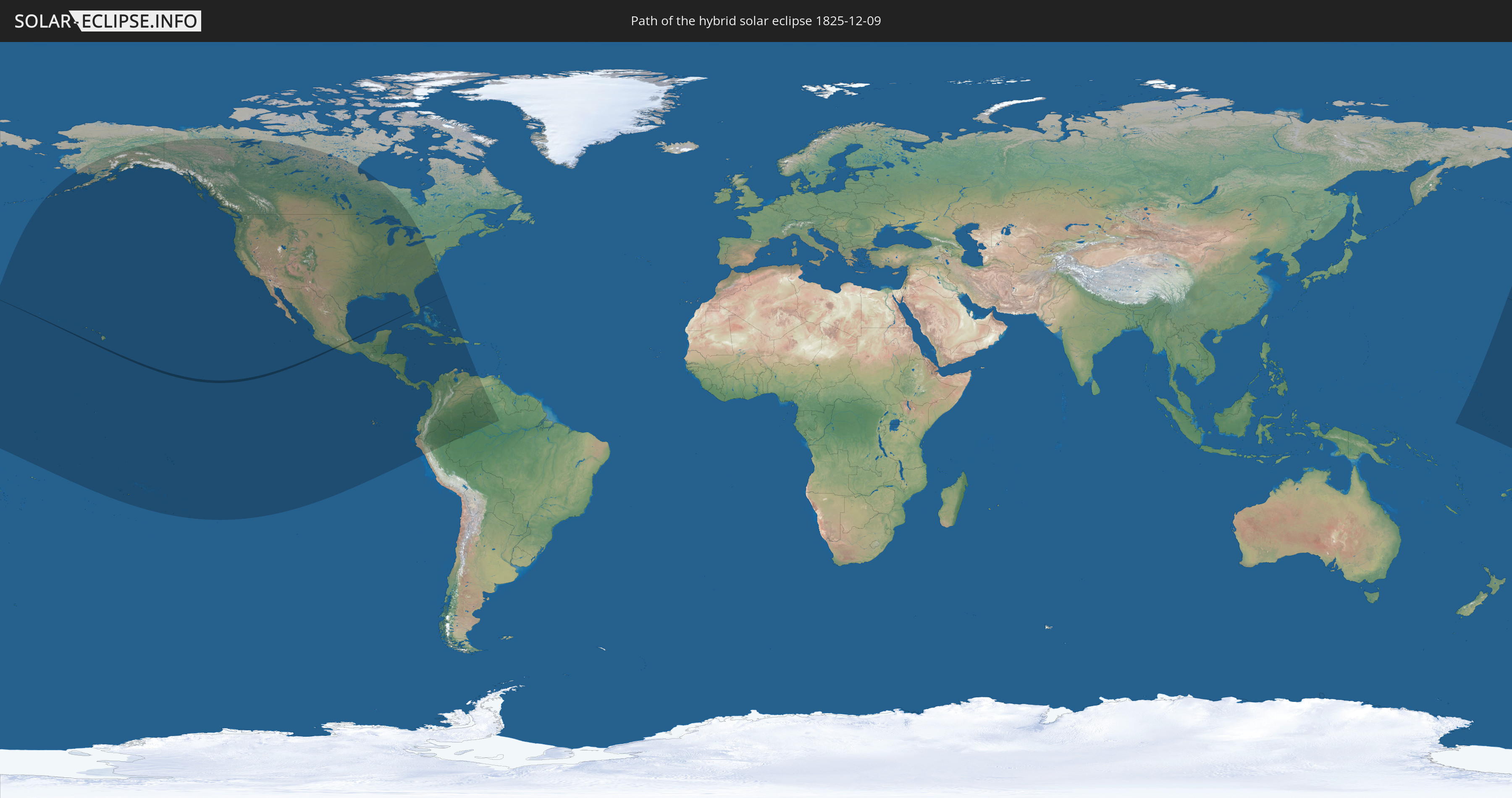
Die Sonnenfinsternis am 12/09/1825 kann man in 31 Ländern als partielle Sonnenfinsternis beobachten.
Der Finsternispfad verläuft durch 2 Länder. Nur in diesen Ländern ist sie als hybrid Sonnenfinsternis zu sehen.
In den folgenden Ländern ist die Sonnenfinsternis hybrid zu sehen
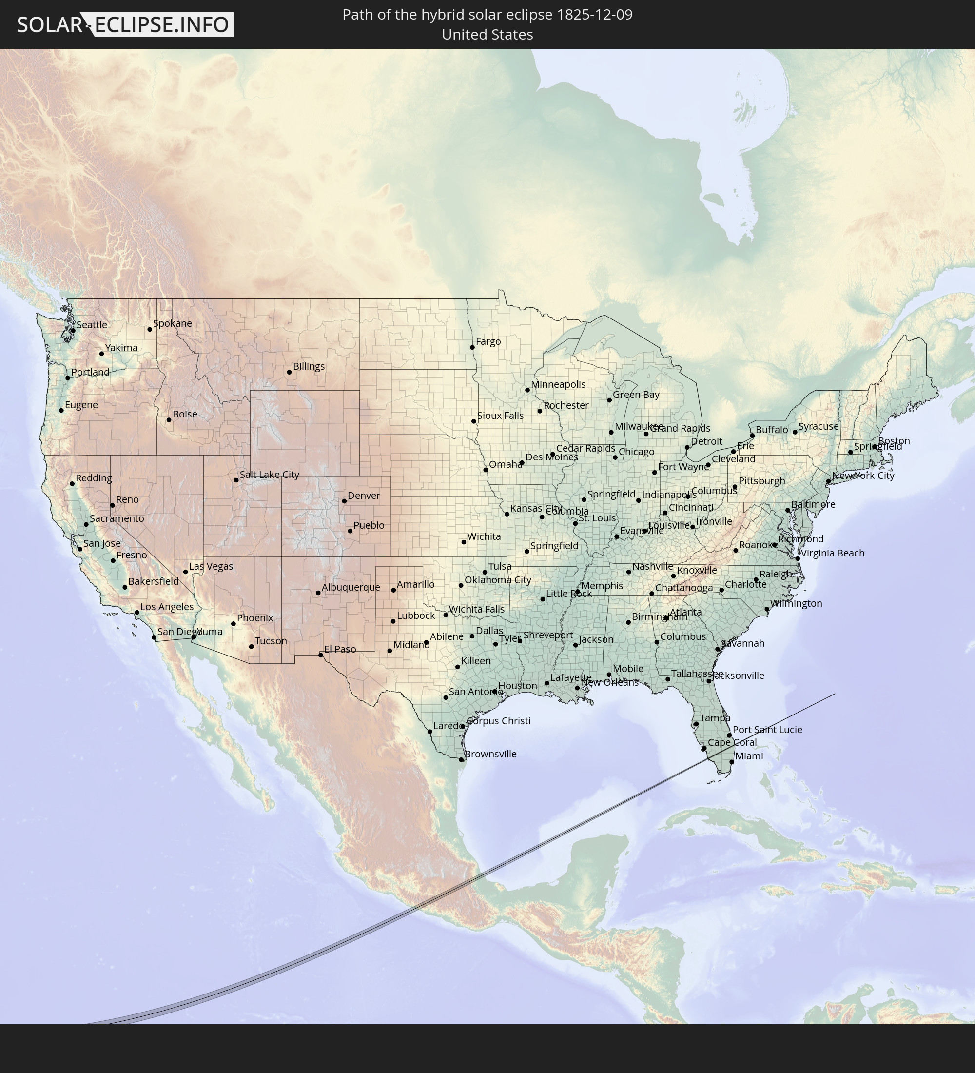 United States
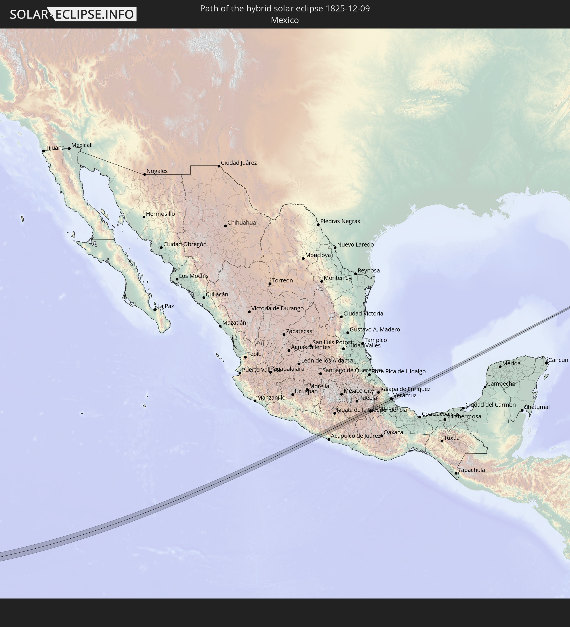 Mexico
In den folgenden Ländern ist die Sonnenfinsternis partiell zu sehen
 United States
 United States Minor Outlying Islands
 Kiribati
 Tokelau
 Cook Islands
 French Polynesia
 Canada
 Mexico
 Greenland
 Guatemala
 Ecuador
 El Salvador
 Honduras
 Belize
 Nicaragua
 Costa Rica
 Cuba
Cuba
 Panama
 Colombia
 Cayman Islands
 Peru
Peru
 The Bahamas
 Jamaica
 Haiti
Haiti
 Brazil
 Venezuela
 Turks and Caicos Islands
 Dominican Republic
 Aruba
Aruba
 Marshall Islands
 Nauru
Nauru
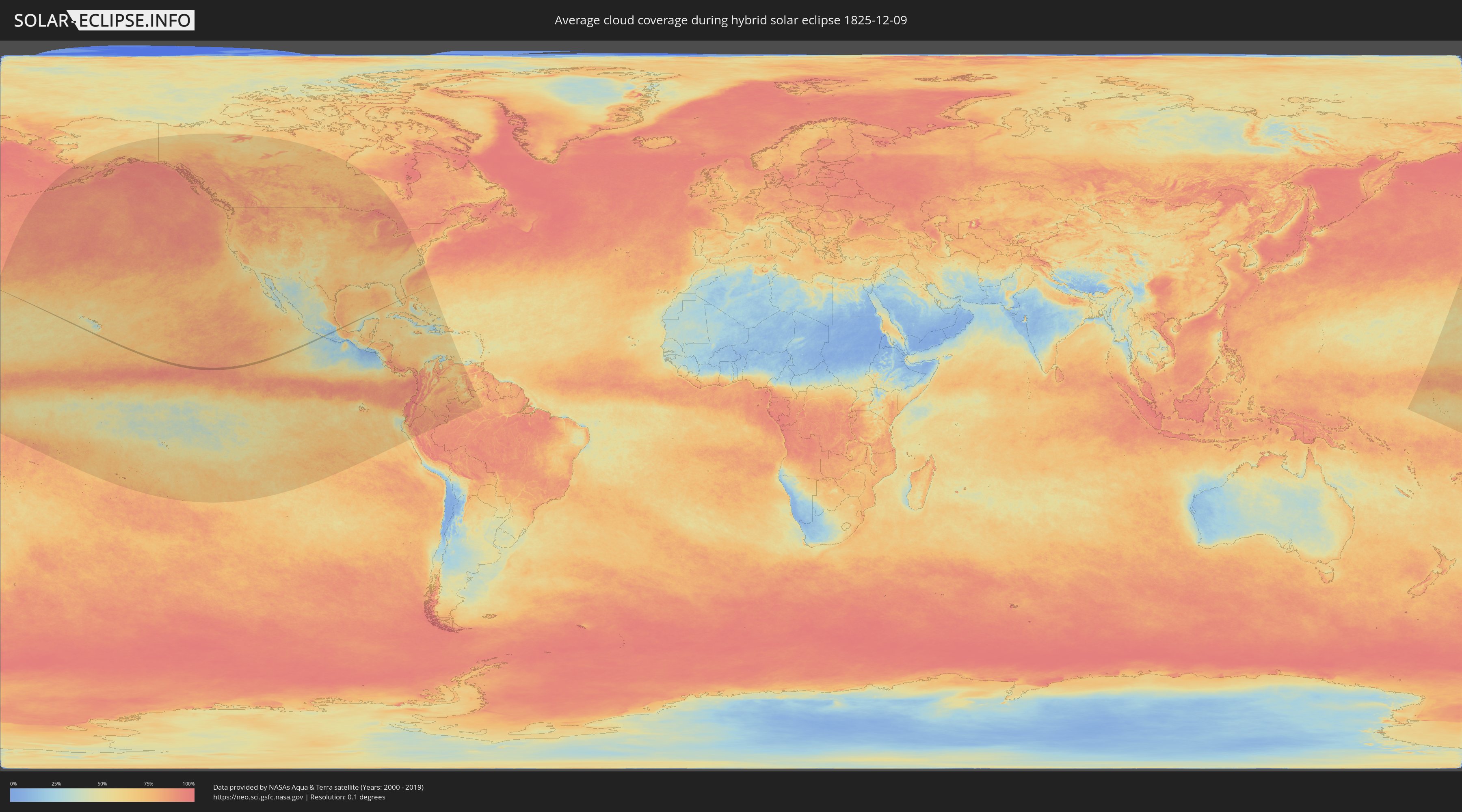
How will be the weather during the hybrid solar eclipse on 12/09/1825?
Where is the best place to see the hybrid solar eclipse of 12/09/1825?
The following maps show the average cloud coverage for the day of the hybrid solar eclipse.
With the help of these maps, it is possible to find the place along the eclipse path, which has the best
chance of a cloudless sky.
Nevertheless, you should consider local circumstances and inform about the weather of your chosen
observation site.
The data is provided by NASAs satellites
AQUA and TERRA.
The cloud maps are averaged over a period of 19 years (2000 - 2019).

Detailed country maps
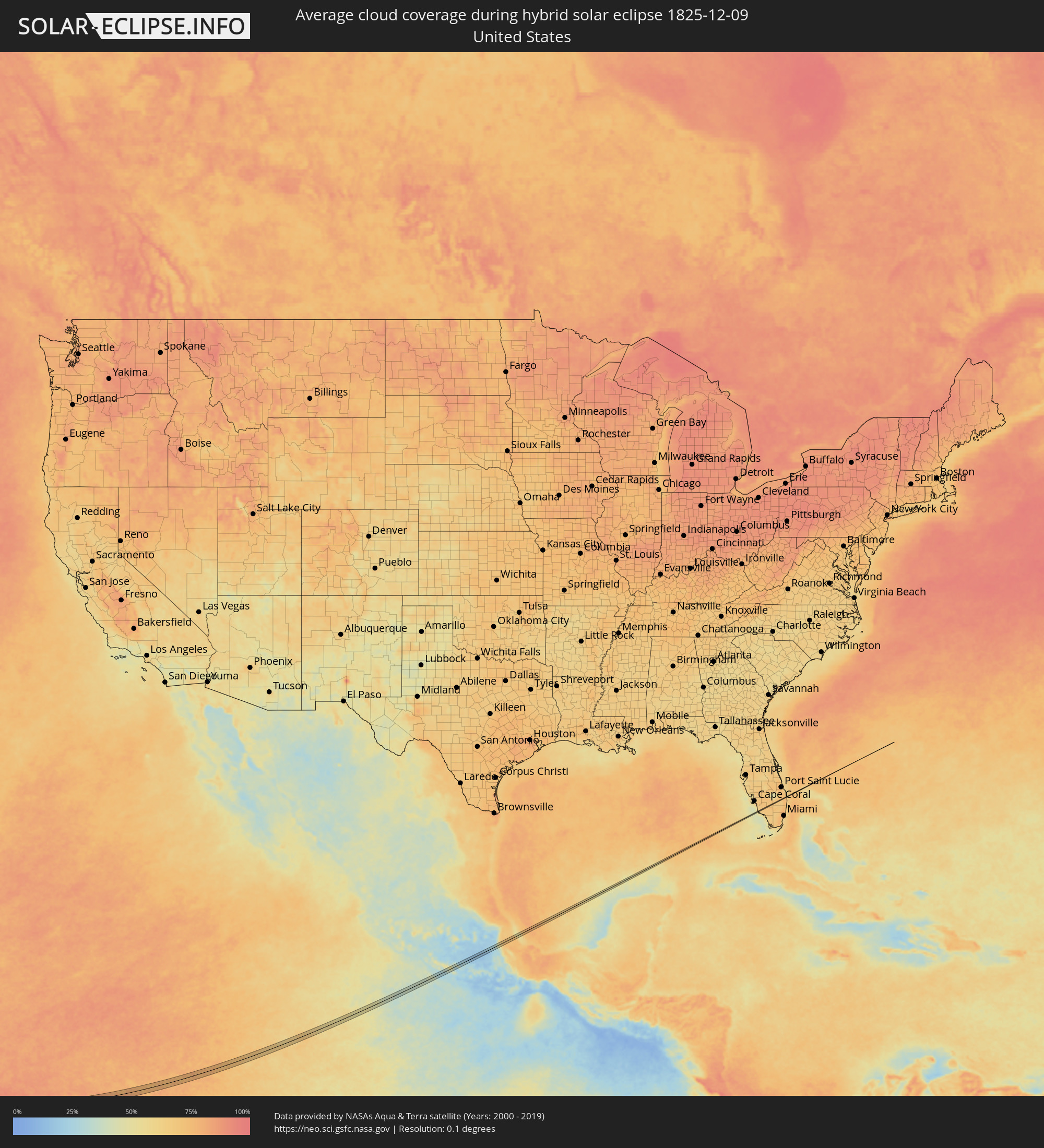 United States
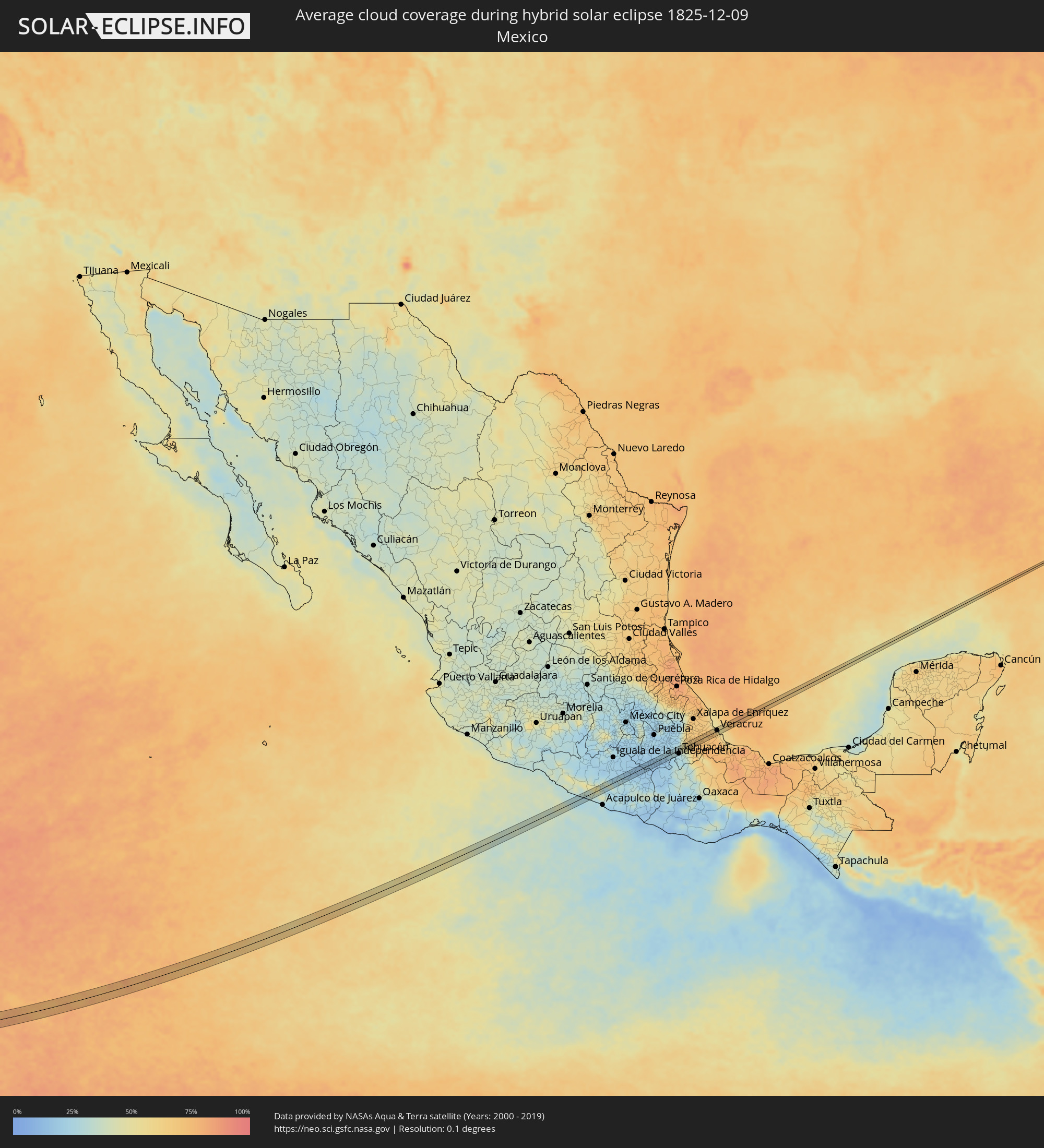 Mexico
Cities inside the path of the eclipse
The following table shows all locations with a population of more than 5,000 inside the eclipse path. Cities which have more than 100,000 inhabitants are marked bold. A click at the locations opens a detailed map.
| City | Type | Eclipse duration | Local time of max. eclipse | Distance to central line | Ø Cloud coverage |
|
San Jerónimo de Juárez, Guerrero
|
total | - | 14:56:47 UTC-06:36 | 2 km | 28% |
|
Atoyac de Álvarez, Guerrero
|
total | - | 14:56:50 UTC-06:36 | 7 km | 28% |
|
Zumpango del Río, Guerrero
|
total | - | 14:58:14 UTC-06:36 | 9 km | 26% |
|
Chilpancingo, Guerrero
|
total | - | 14:58:17 UTC-06:36 | 2 km | 26% |
|
Petaquillas, Guerrero
|
total | - | 14:58:22 UTC-06:36 | 11 km | 30% |
|
Tixtla de Guerrero, Guerrero
|
total | - | 14:58:27 UTC-06:36 | 5 km | 27% |
|
Atliaca, Guerrero
|
total | - | 14:58:28 UTC-06:36 | 2 km | 28% |
|
Zitlala, Guerrero
|
total | - | 14:58:46 UTC-06:36 | 3 km | 26% |
|
Chilapa de Alvarez, Guerrero
|
total | - | 14:58:48 UTC-06:36 | 13 km | 26% |
|
Xochihuehuetlán, Guerrero
|
total | - | 14:59:48 UTC-06:36 | 14 km | 19% |
|
Tulcingo de Valle, Puebla
|
total | - | 14:59:50 UTC-06:36 | 3 km | 17% |
|
Acatlán de Osorio, Puebla
|
total | - | 15:00:24 UTC-06:36 | 6 km | 16% |
|
San Bartolo Teontepec, Puebla
|
total | - | 15:01:06 UTC-06:36 | 2 km | 27% |
|
Magdalena Cuayucatepec, Puebla
|
total | - | 15:01:09 UTC-06:36 | 2 km | 27% |
|
Santiago Miahuatlán, Puebla
|
total | - | 15:01:13 UTC-06:36 | 0 km | 28% |
|
Tehuacán, Puebla
|
total | - | 15:01:18 UTC-06:36 | 11 km | 28% |
|
Acultzingo, Veracruz
|
total | - | 15:01:22 UTC-06:36 | 11 km | 45% |
|
Ciudad Mendoza, Veracruz
|
total | - | 15:01:32 UTC-06:36 | 13 km | 51% |
|
Jalapilla, Veracruz
|
total | - | 15:01:39 UTC-06:36 | 11 km | 61% |
|
Rafael Delgado, Veracruz
|
total | - | 15:01:41 UTC-06:36 | 9 km | 61% |
|
Ixtaczoquitlán, Veracruz
|
total | - | 15:01:41 UTC-06:36 | 13 km | 64% |
|
Cuautlapán, Veracruz
|
total | - | 15:01:44 UTC-06:36 | 13 km | 64% |
|
Zongolica, Veracruz
|
total | - | 15:01:49 UTC-06:36 | 9 km | 64% |
|
Córdoba, Veracruz
|
total | - | 15:01:52 UTC-06:36 | 9 km | 67% |
|
Amatlán de los Reyes, Veracruz
|
total | - | 15:01:53 UTC-06:36 | 5 km | 71% |
|
Cuichapa, Veracruz
|
total | - | 15:01:58 UTC-06:36 | 5 km | 71% |
|
Yanga, Veracruz
|
total | - | 15:02:03 UTC-06:36 | 2 km | 73% |
|
Paso del Macho, Veracruz
|
total | - | 15:02:08 UTC-06:36 | 8 km | 69% |
|
Cuitláhuac, Veracruz
|
total | - | 15:02:10 UTC-06:36 | 7 km | 72% |
|
Soledad de Doblado, Veracruz
|
total | - | 15:02:32 UTC-06:36 | 1 km | 72% |
|
Fraccionamiento Geovillas los Pinos, Veracruz
|
total | - | 15:02:45 UTC-06:36 | 9 km | 68% |
|
Las Amapolas, Veracruz
|
total | - | 15:02:48 UTC-06:36 | 1 km | 68% |
|
El Tejar, Veracruz
|
total | - | 15:02:53 UTC-06:36 | 8 km | 68% |
|
Fraccionamiento Arboledas San Ramón, Veracruz
|
total | - | 15:02:53 UTC-06:36 | 7 km | 68% |
|
Veracruz, Veracruz
|
total | - | 15:02:52 UTC-06:36 | 2 km | 59% |
|
Boca del Río, Veracruz
|
total | - | 15:02:57 UTC-06:36 | 9 km | 62% |
|
Royal Palm Beach, Florida
|
total | - | 16:50:49 UTC-05:00 | 2 km | 75% |
|
North Palm Beach, Florida
|
total | - | 16:50:50 UTC-05:00 | 2 km | 73% |
|
Lake Park, Florida
|
total | - | 16:50:51 UTC-05:00 | 0 km | 73% |