Annular solar eclipse of 10/20/1846
| Day of week: | Tuesday |
| Maximum duration of eclipse: | 05m05s |
| Maximum width of eclipse path: | 159 km |
| Saros cycle: | 131 |
| Coverage: | 95.7% |
| Magnitude: | 0.9567 |
| Gamma: | -0.1506 |
Wo kann man die Sonnenfinsternis vom 10/20/1846 sehen?
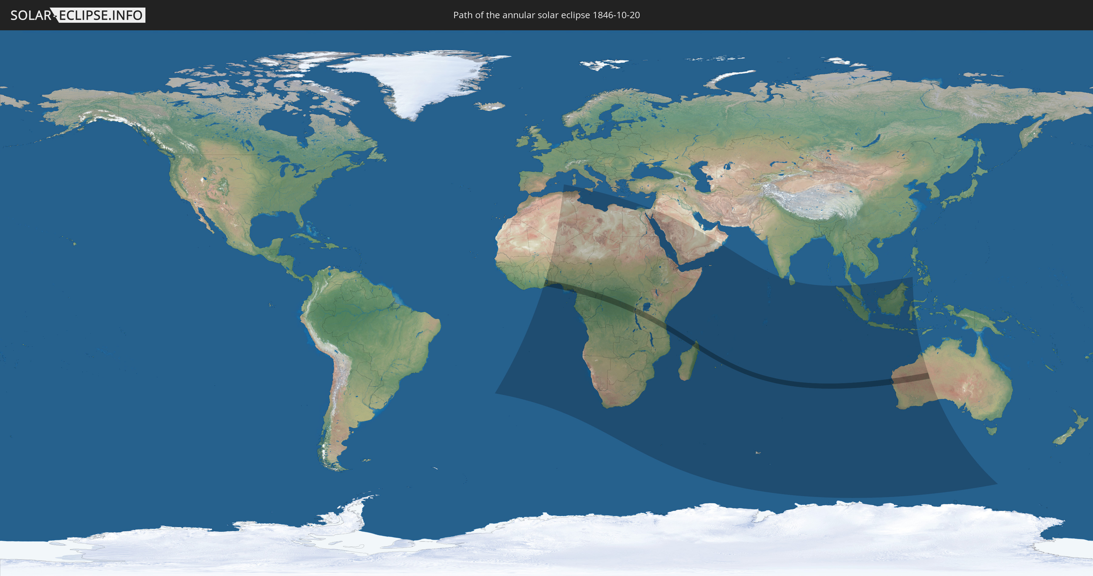
Die Sonnenfinsternis am 10/20/1846 kann man in 69 Ländern als partielle Sonnenfinsternis beobachten.
Der Finsternispfad verläuft durch 14 Länder. Nur in diesen Ländern ist sie als annular Sonnenfinsternis zu sehen.
In den folgenden Ländern ist die Sonnenfinsternis annular zu sehen
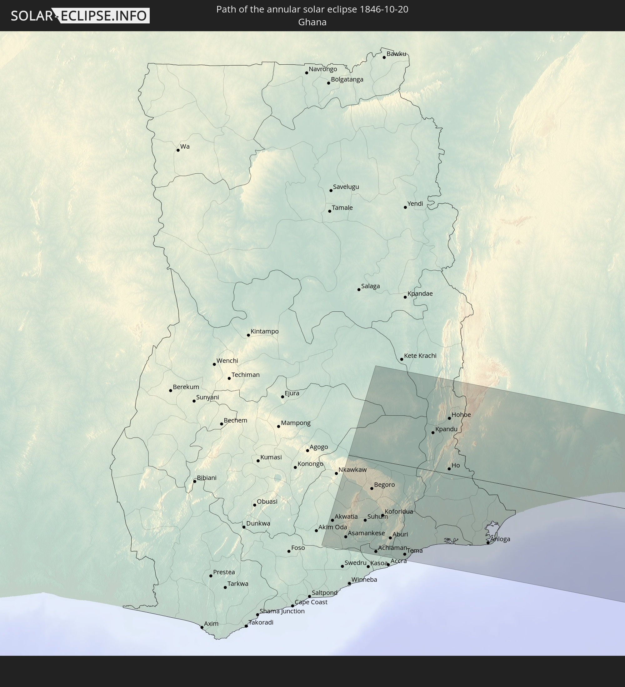 Ghana
Ghana
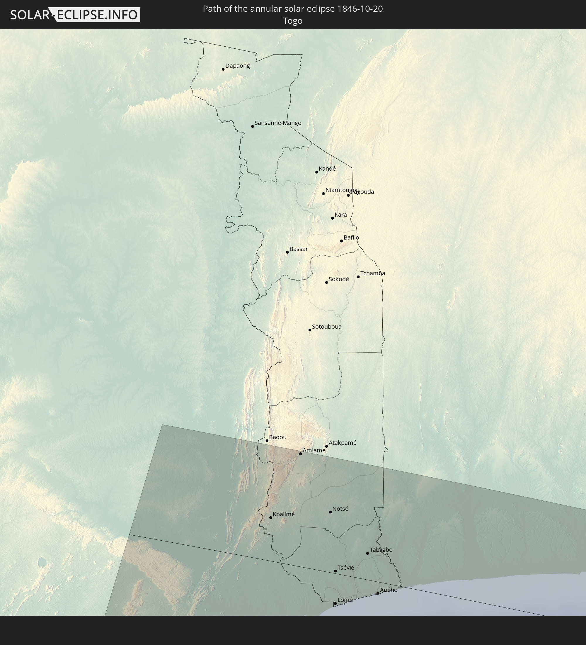 Togo
Togo
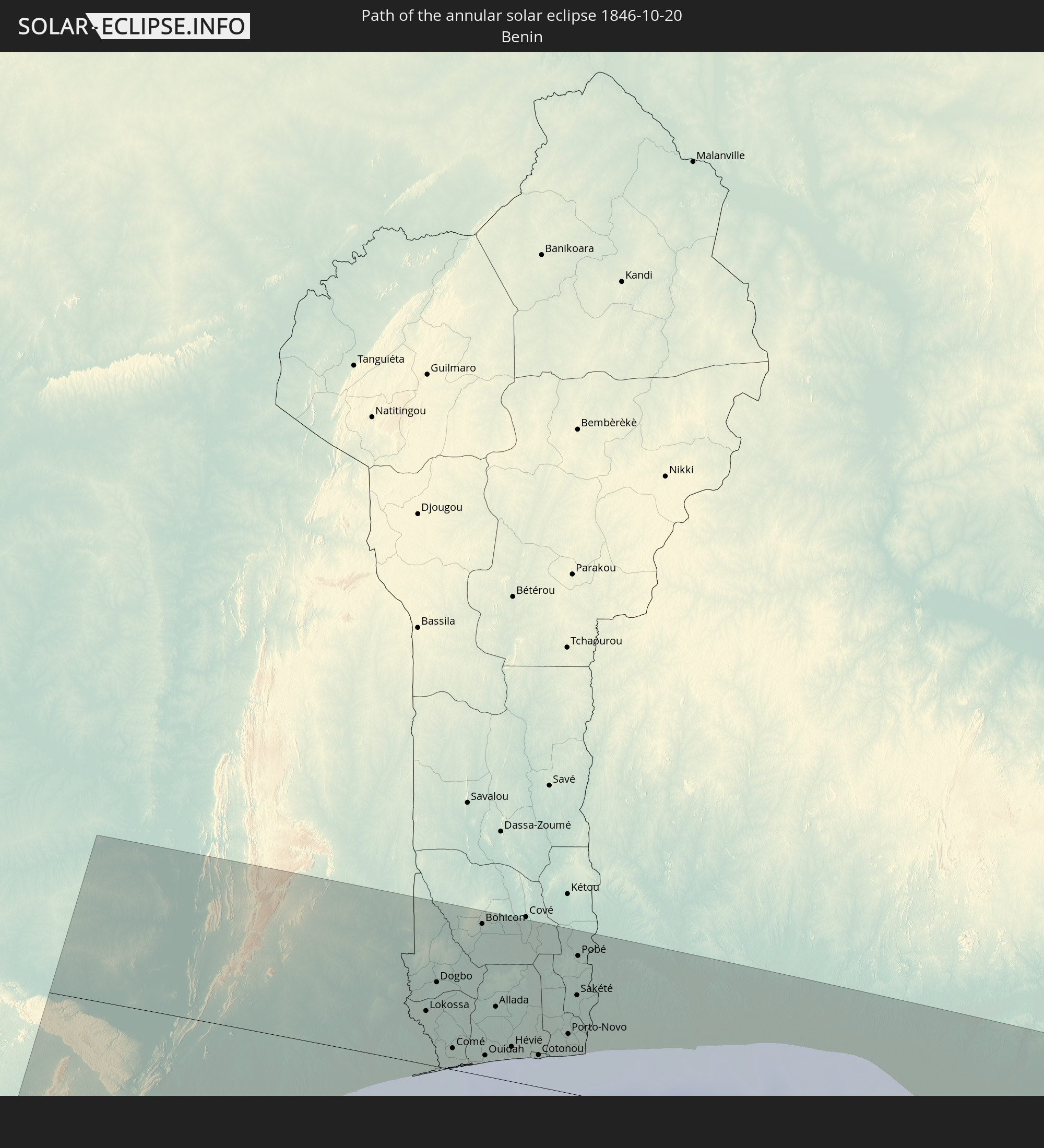 Benin
Benin
 Nigeria
 Equatorial Guinea
 Cameroon
 Republic of the Congo
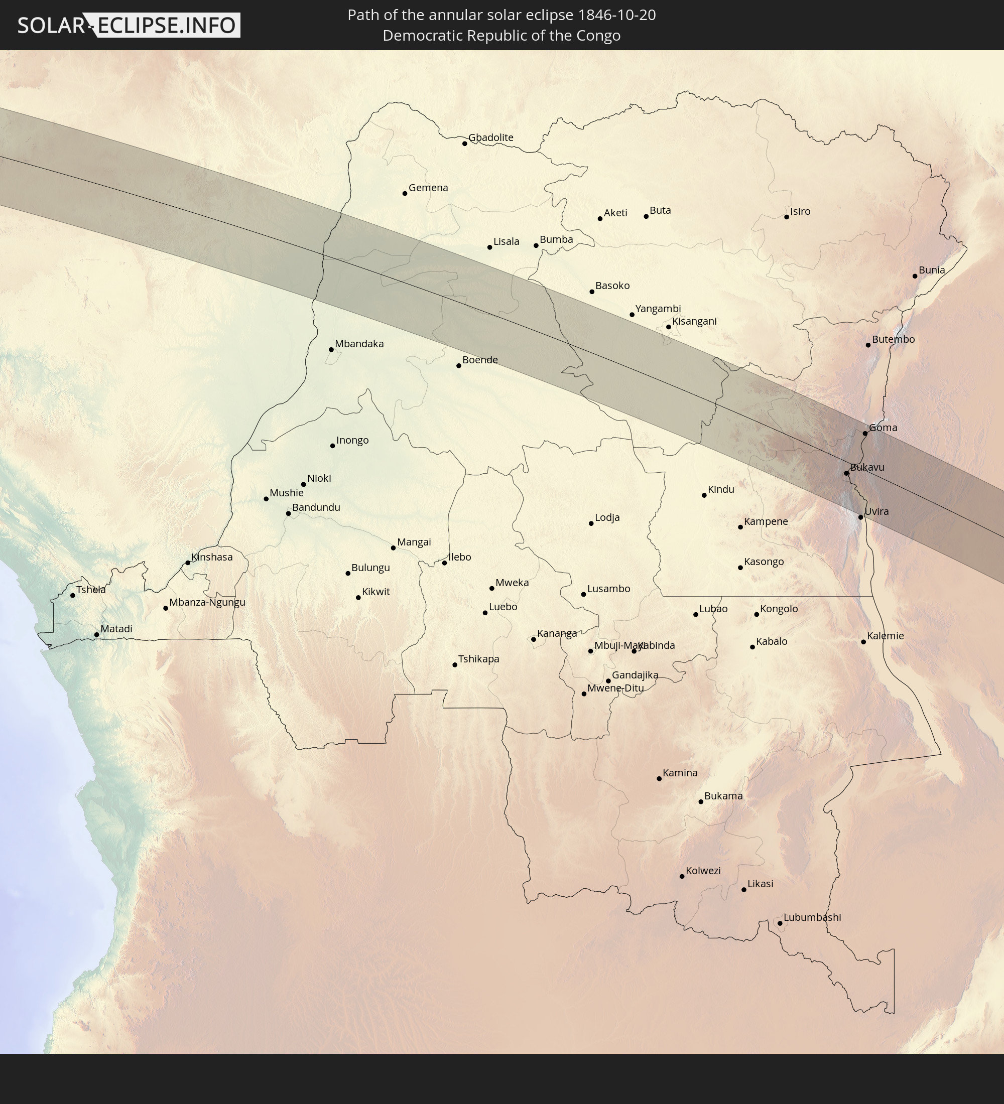 Democratic Republic of the Congo
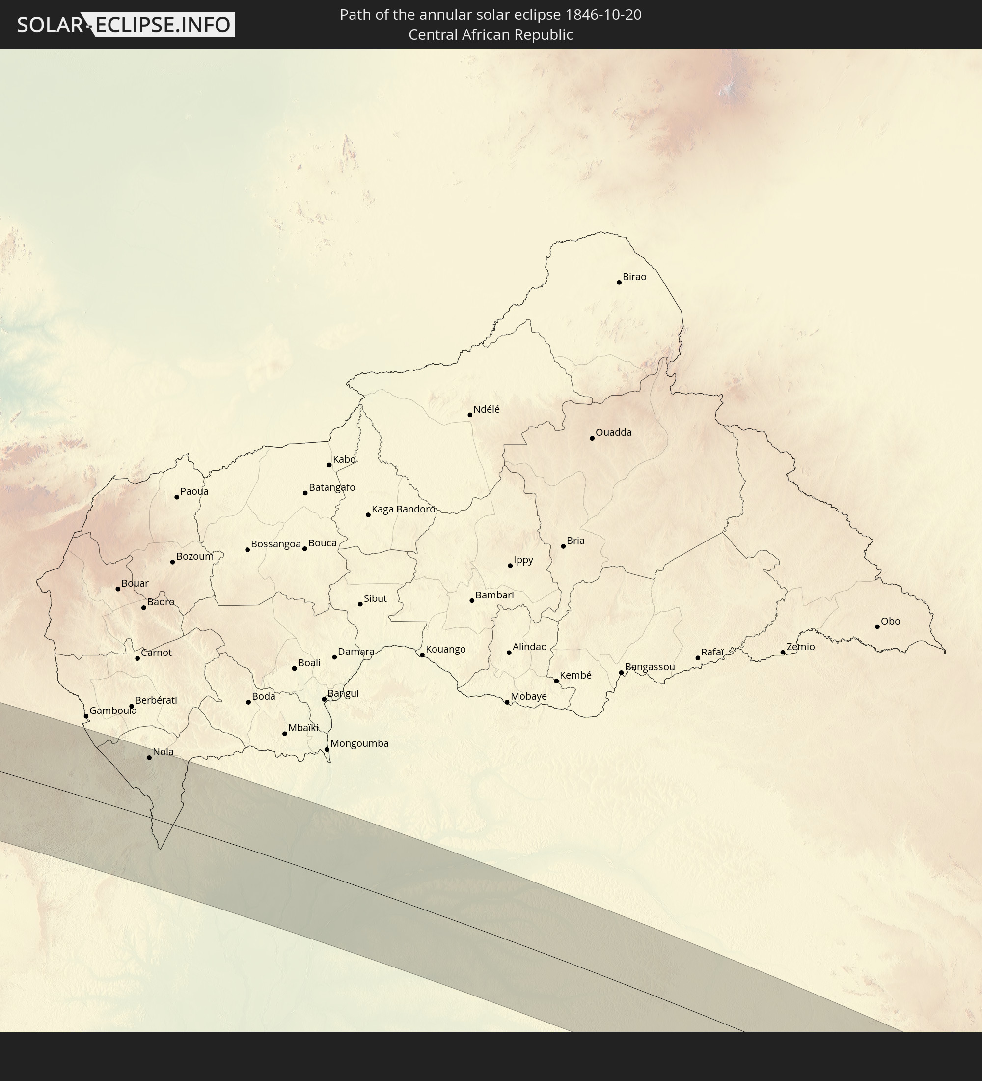 Central African Republic
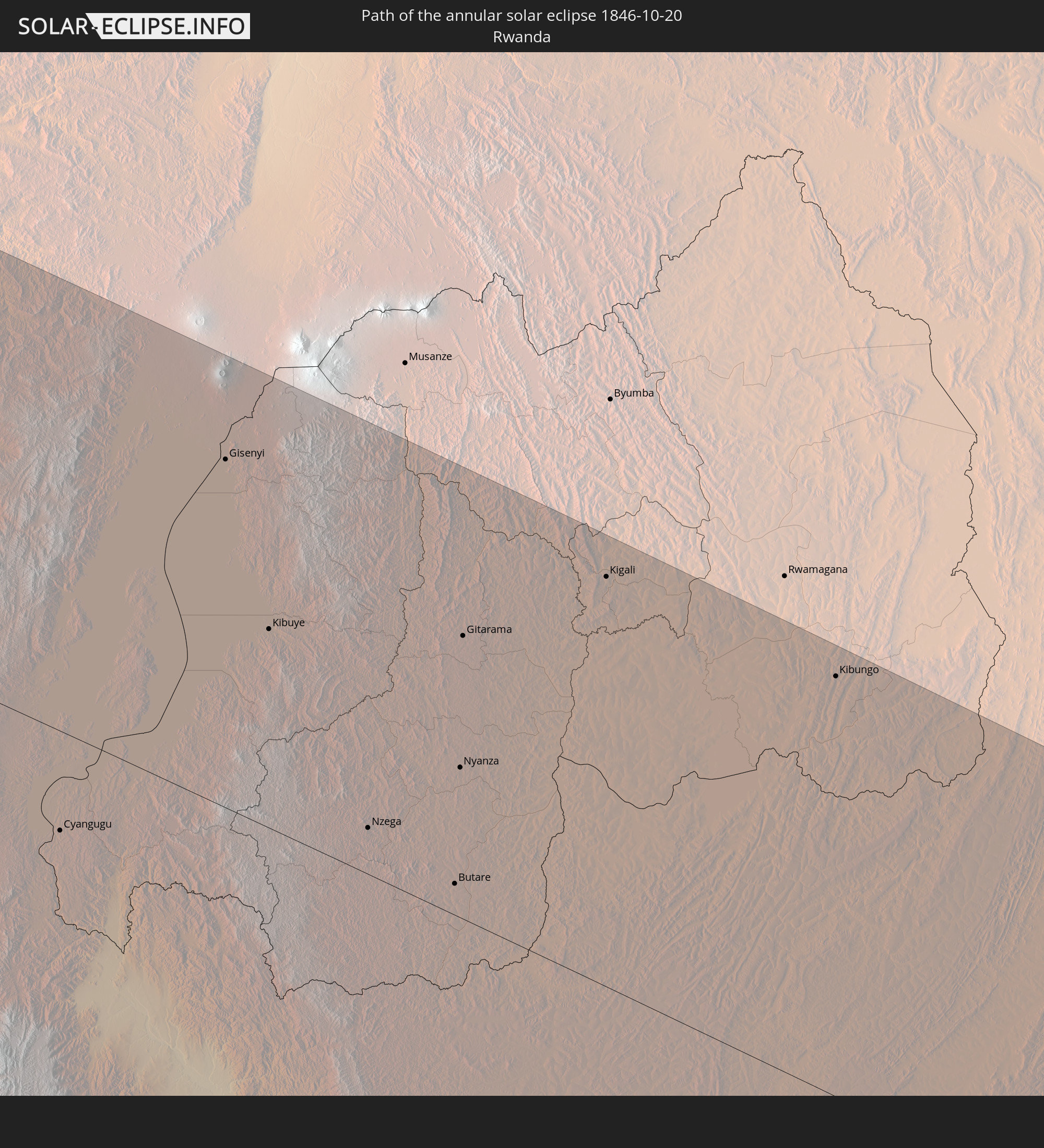 Rwanda
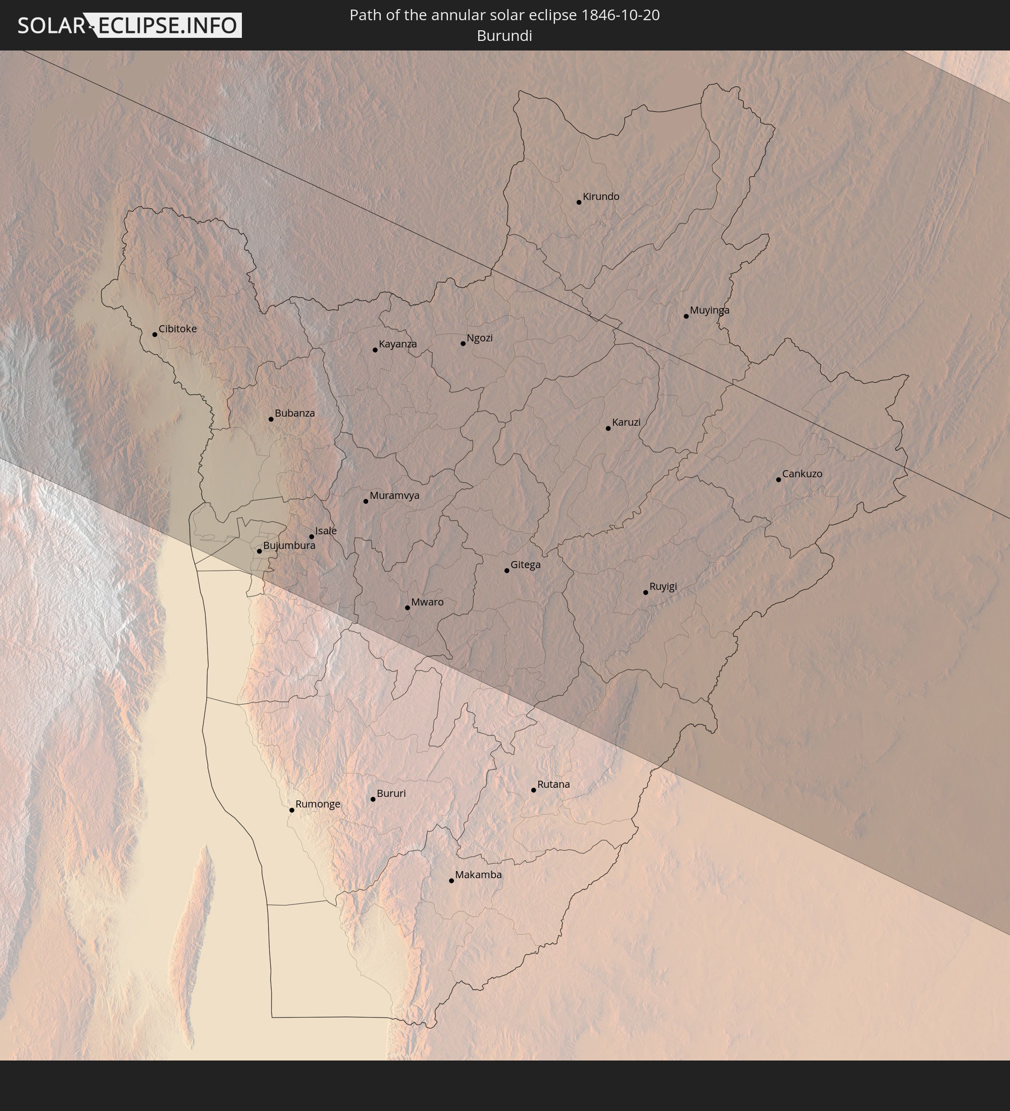 Burundi
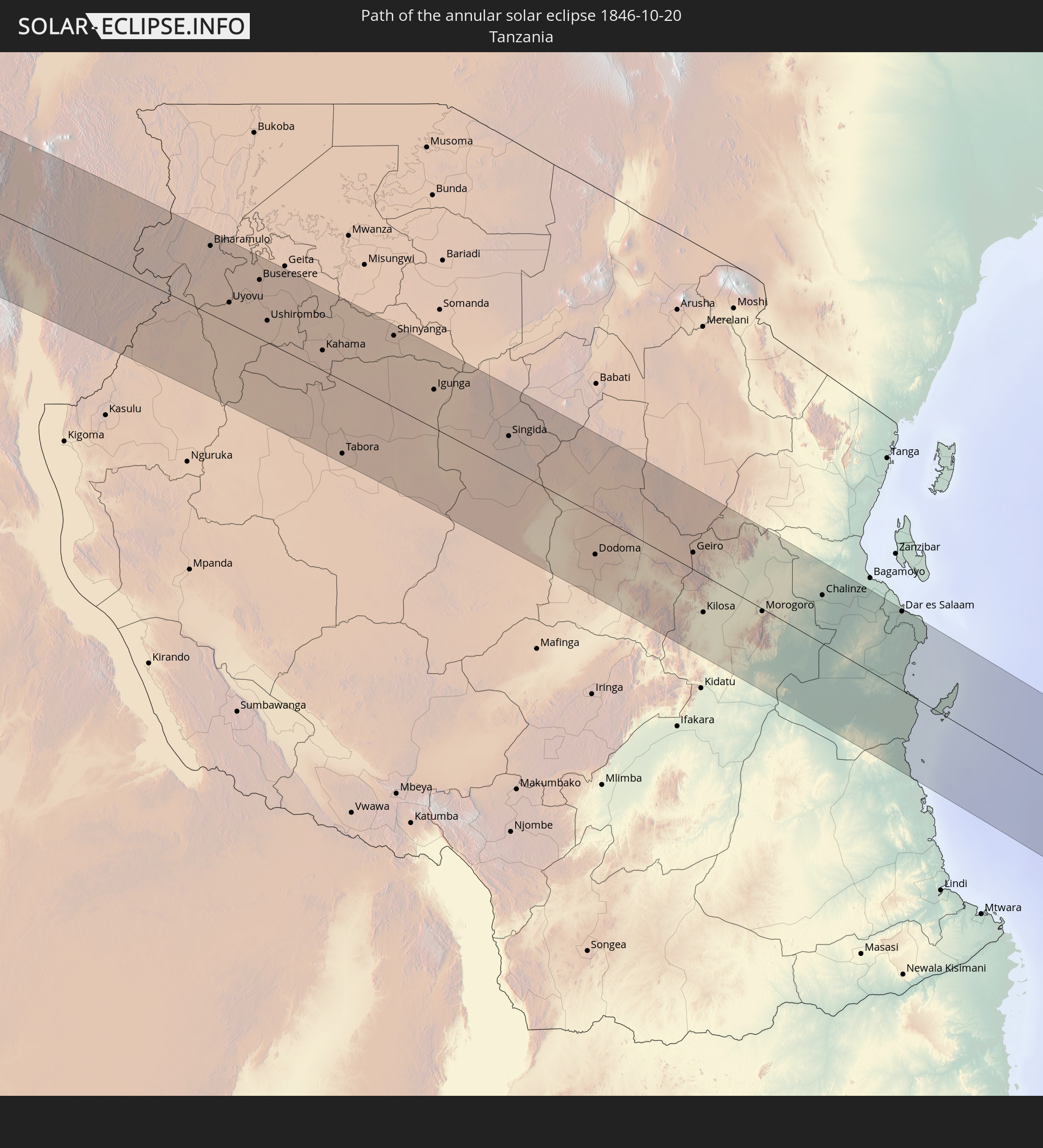 Tanzania
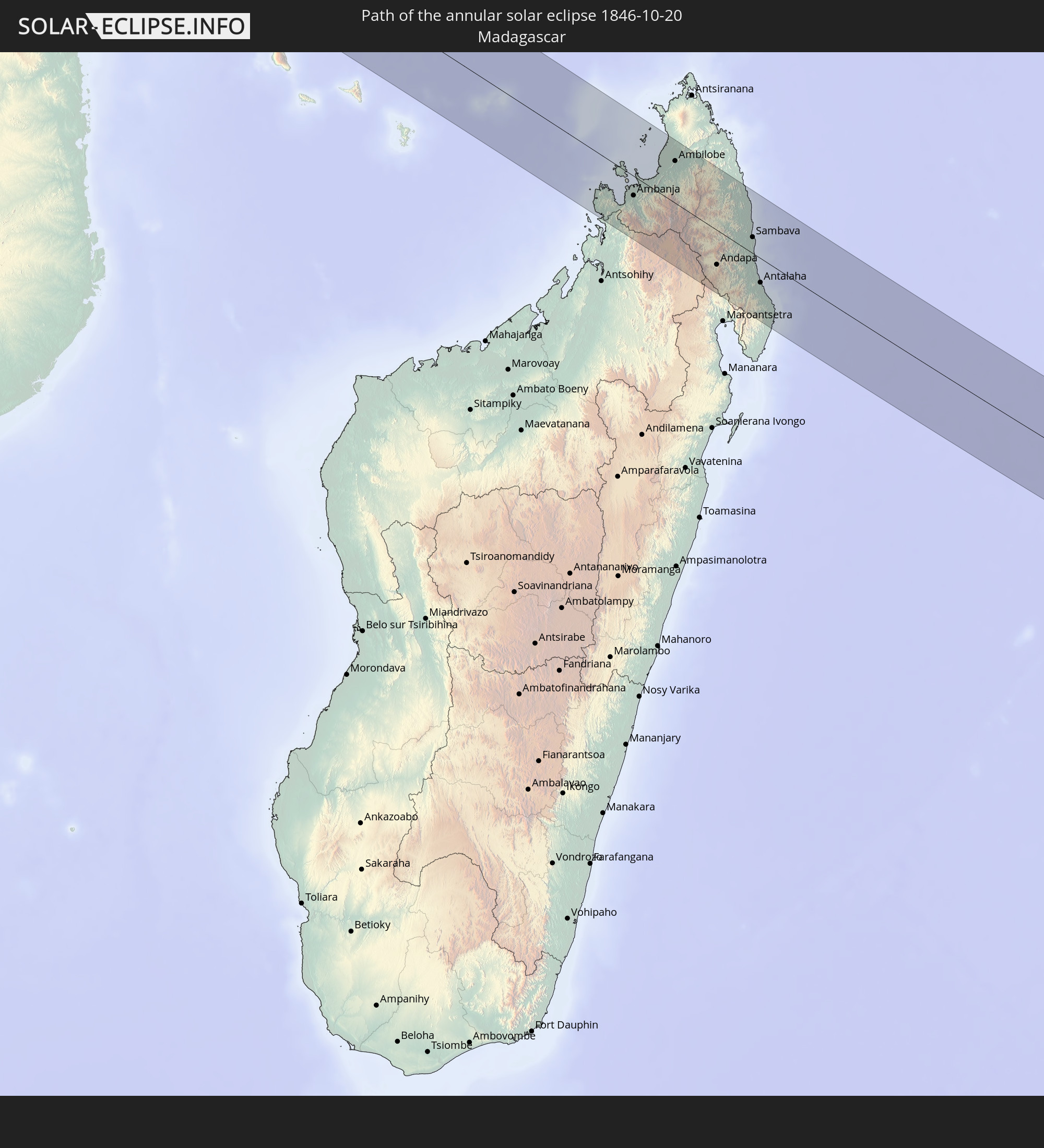 Madagascar
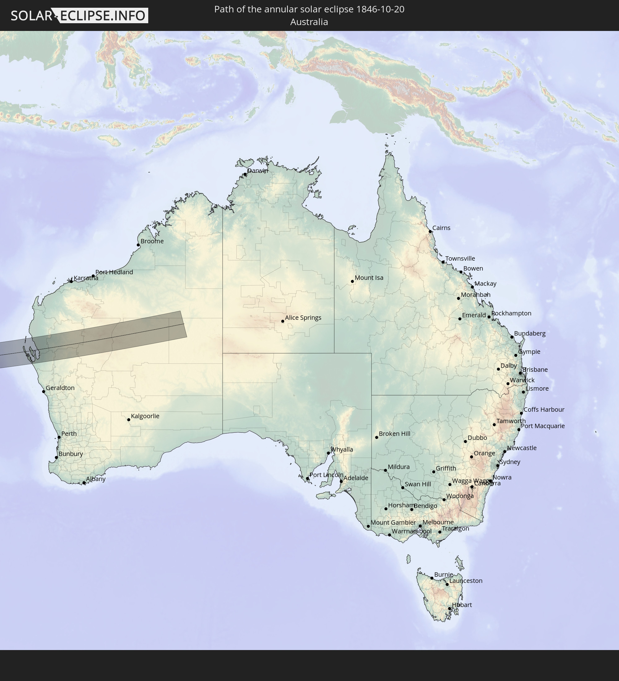 Australia
In den folgenden Ländern ist die Sonnenfinsternis partiell zu sehen
 Saint Helena, Ascension and Tristan da Cunha
 Mali
Mali
 Algeria
 Burkina Faso
 Ghana
Ghana
 Togo
Togo
 Niger
Niger
 Benin
Benin
 Nigeria
 Equatorial Guinea
 São Tomé and Príncipe
 Italy
Italy
 Tunisia
 Cameroon
 Gabon
Gabon
 Libya
Libya
 Republic of the Congo
 Angola
 Namibia
 Democratic Republic of the Congo
 Chad
Chad
 Malta
Malta
 Central African Republic
 South Africa
 Botswana
 Sudan
Sudan
 Zambia
 Egypt
Egypt
 Zimbabwe
 Lesotho
 Rwanda
 Burundi
 Tanzania
 Uganda
 Mozambique
 Swaziland
 Malawi
 Ethiopia
 Kenya
Kenya
 State of Palestine
 Israel
 Saudi Arabia
 Jordan
 Eritrea
 French Southern and Antarctic Lands
 Somalia
 Djibouti
 Yemen
Yemen
 Madagascar
 Comoros
 Mayotte
 Seychelles
 Oman
Oman
 Réunion
 Mauritius
 India
India
 British Indian Ocean Territory
 Heard Island and McDonald Islands
 Maldives
 Sri Lanka
 Indonesia
 Cocos Islands
 Thailand
 Malaysia
 Singapore
 Christmas Island
 Australia
 Brunei
 Philippines
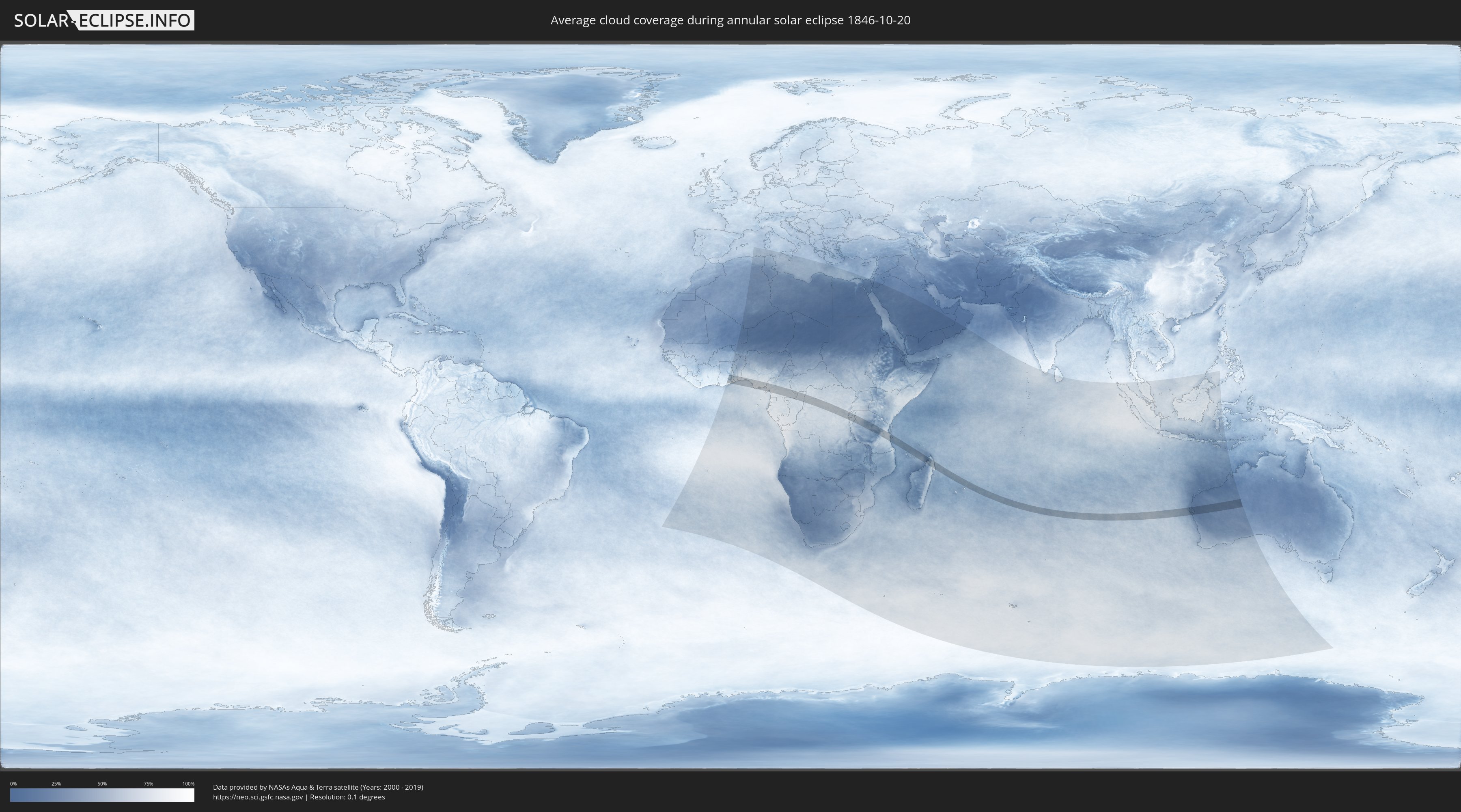
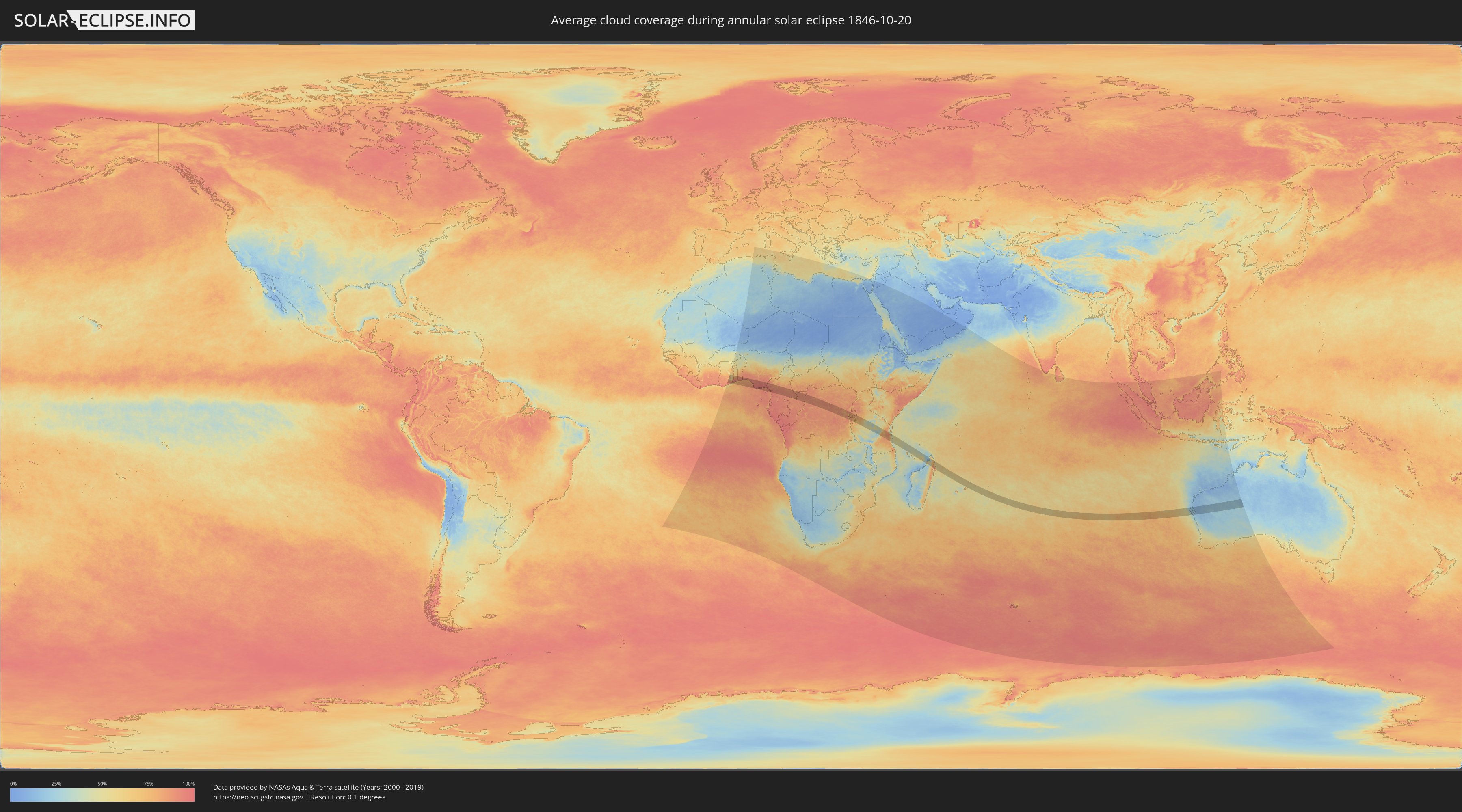
How will be the weather during the annular solar eclipse on 10/20/1846?
Where is the best place to see the annular solar eclipse of 10/20/1846?
The following maps show the average cloud coverage for the day of the annular solar eclipse.
With the help of these maps, it is possible to find the place along the eclipse path, which has the best
chance of a cloudless sky.
Nevertheless, you should consider local circumstances and inform about the weather of your chosen
observation site.
The data is provided by NASAs satellites
AQUA and TERRA.
The cloud maps are averaged over a period of 19 years (2000 - 2019).
Detailed country maps
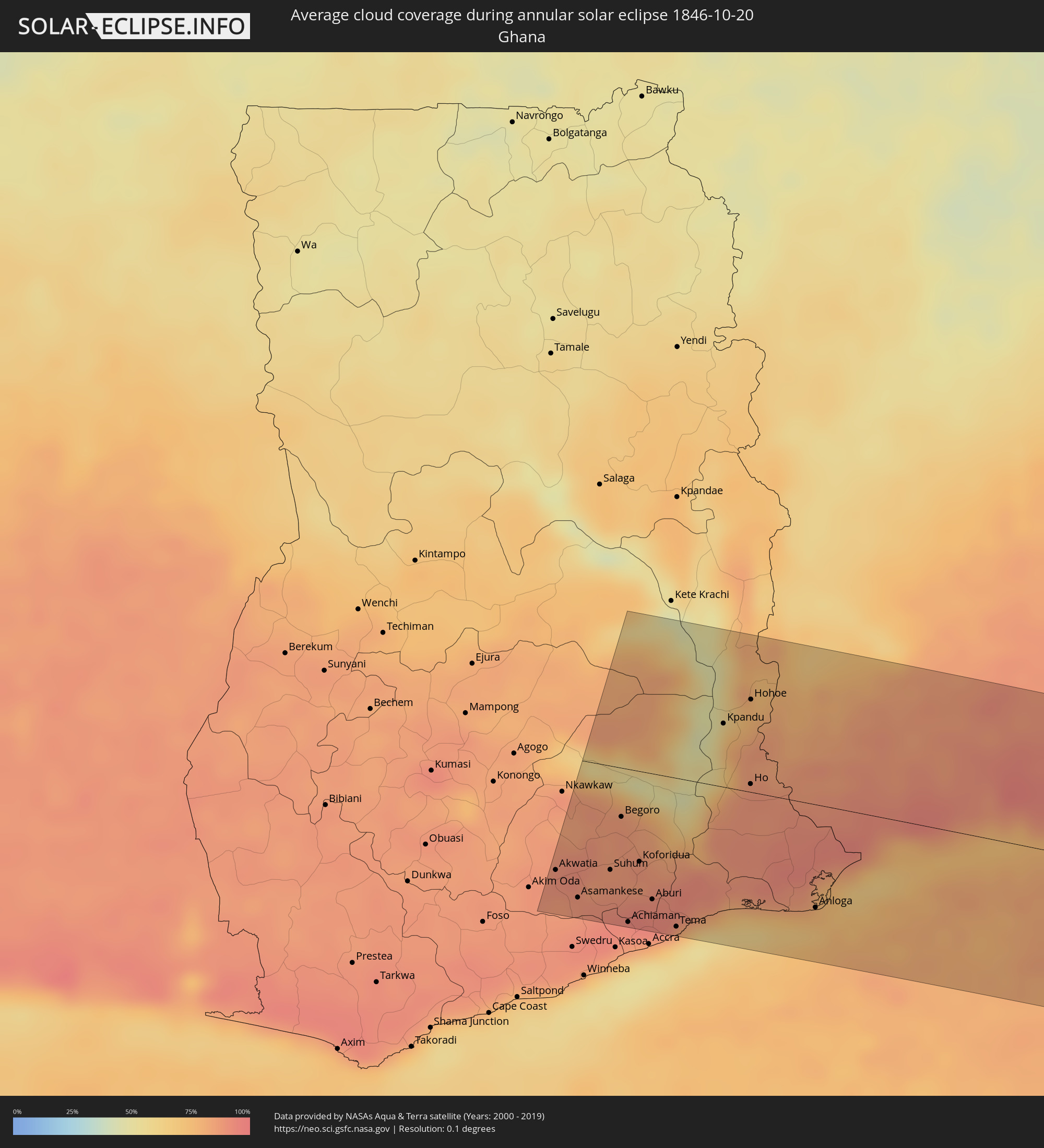 Ghana
Ghana
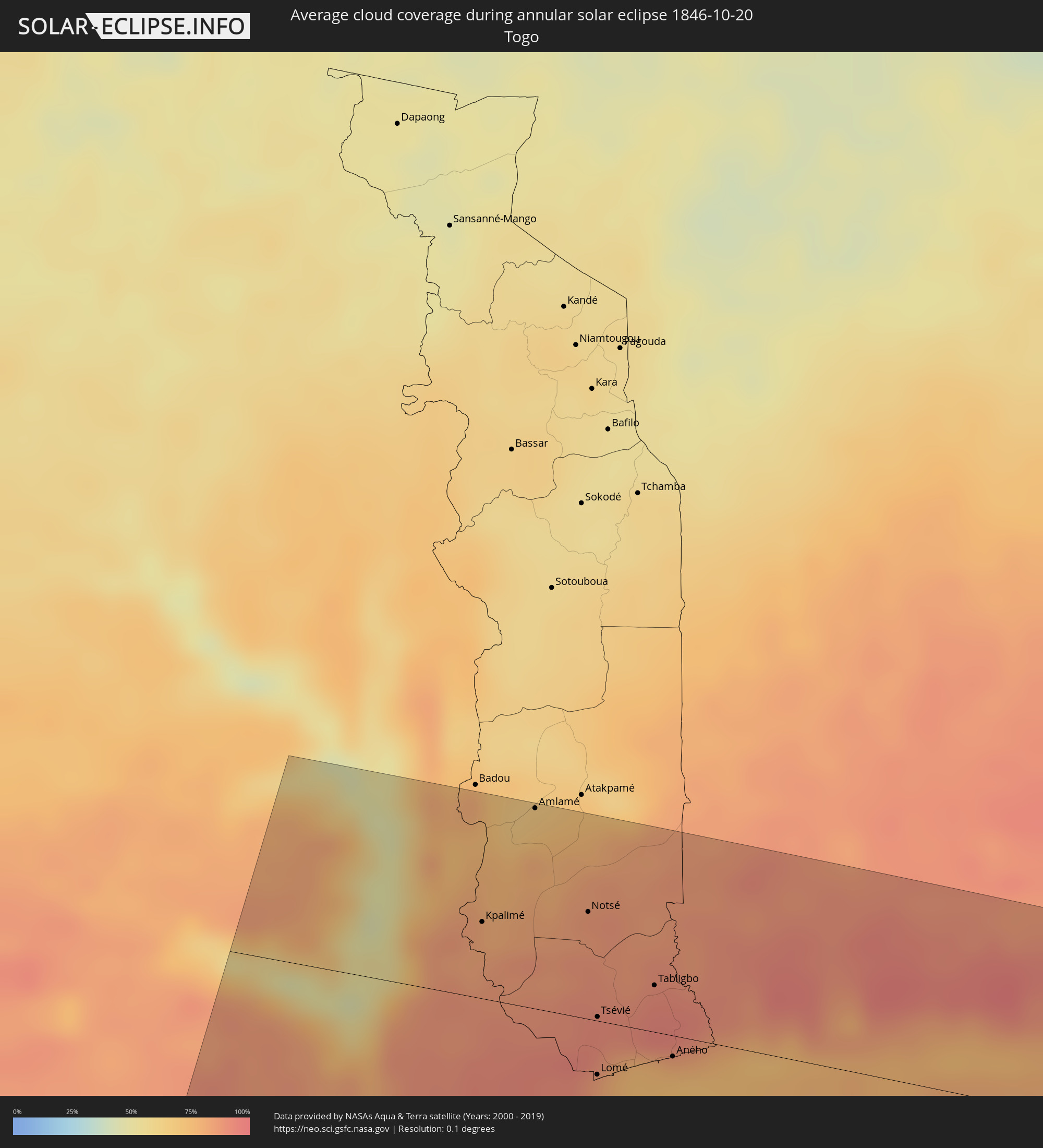 Togo
Togo
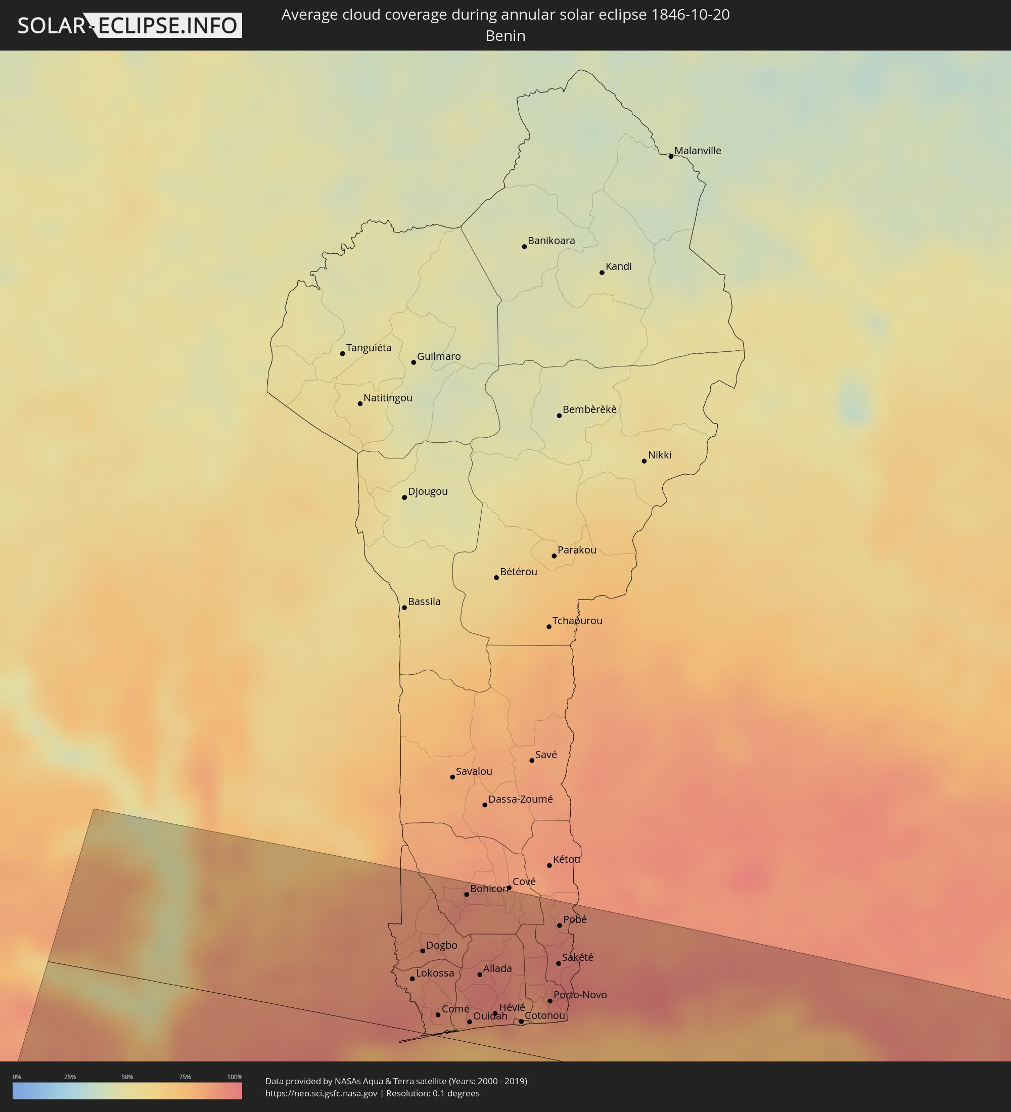 Benin
Benin
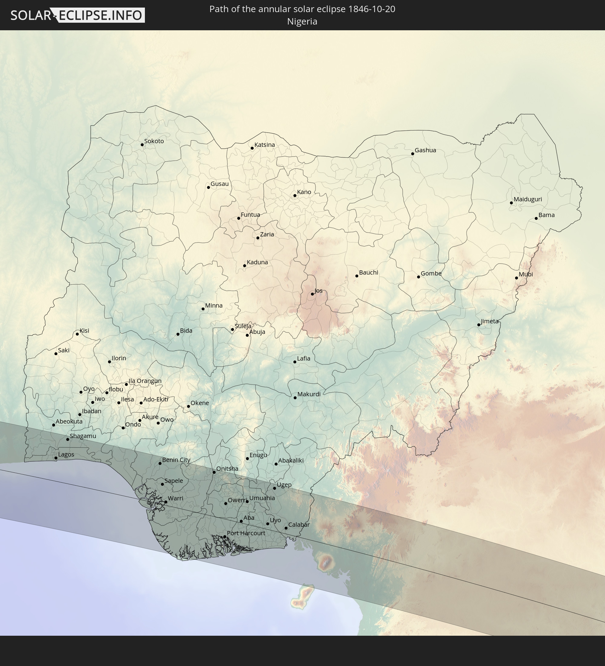
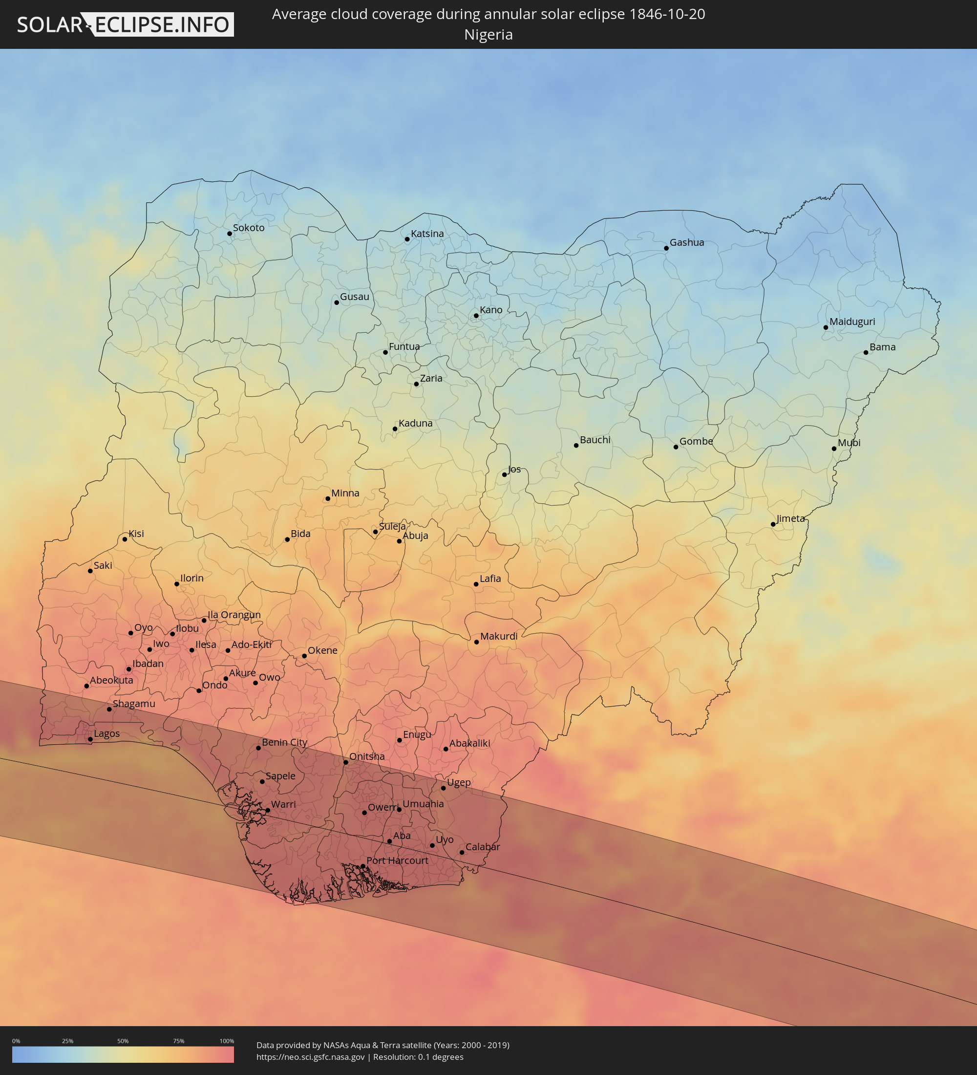 Nigeria
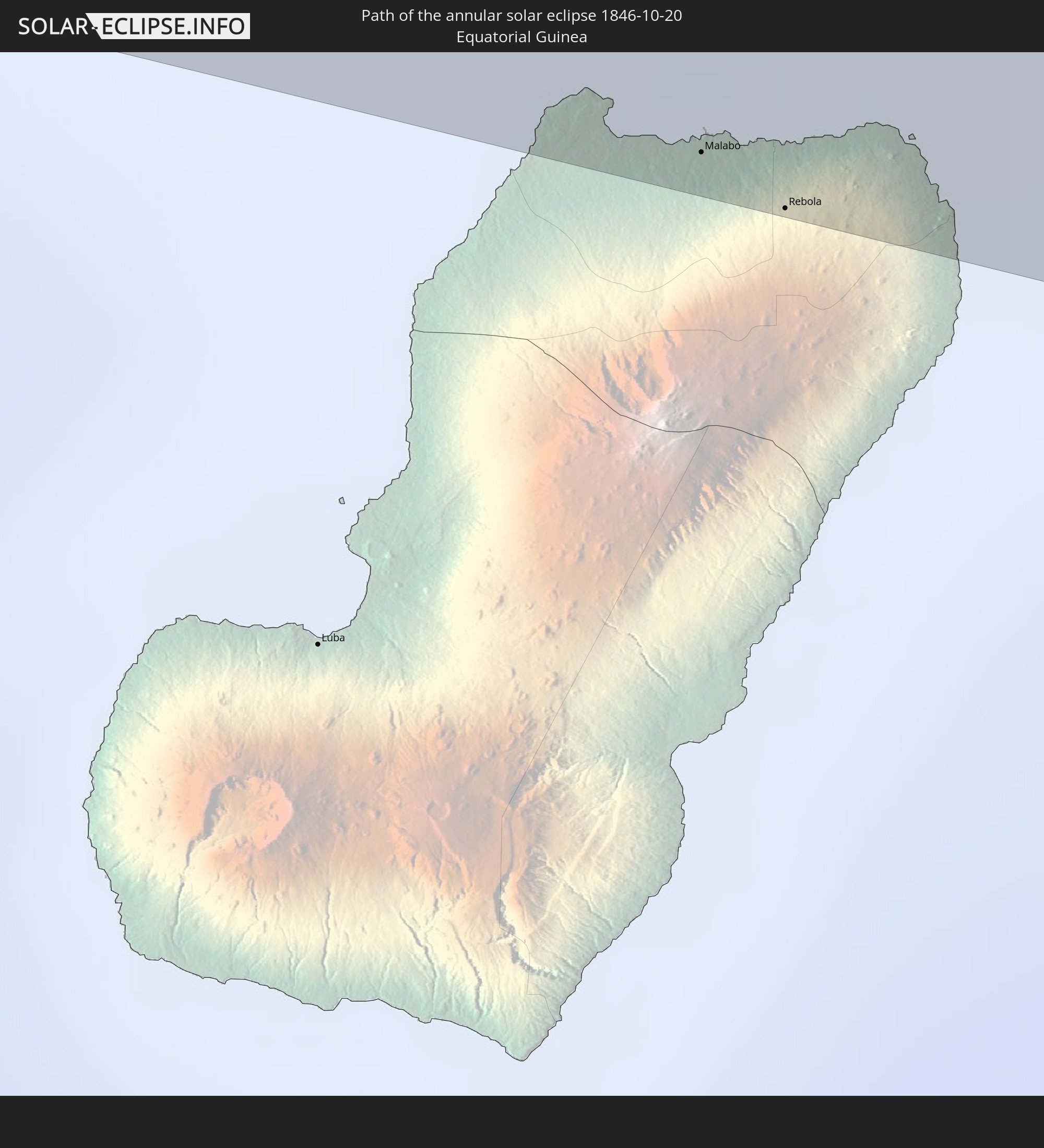
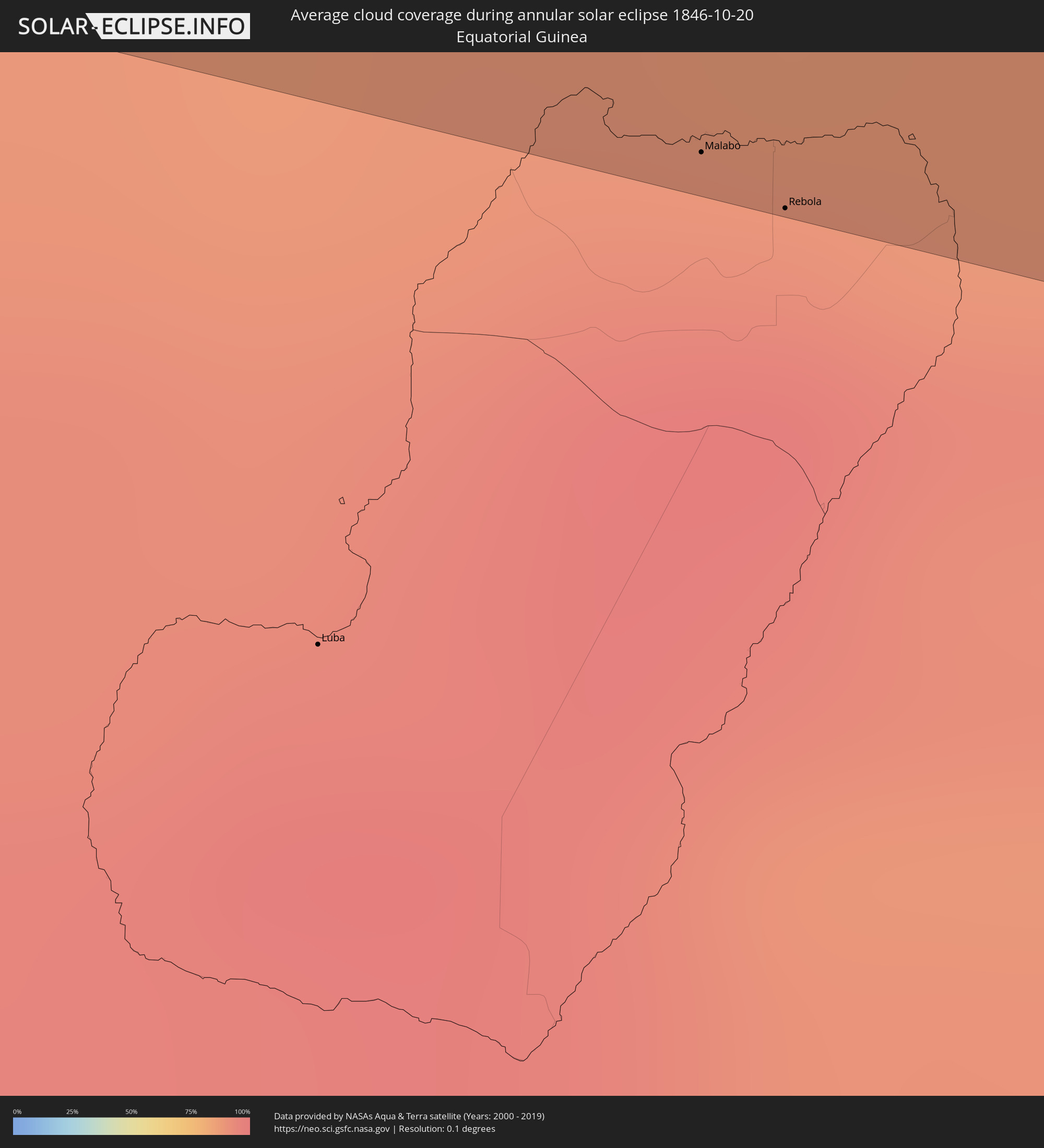 Equatorial Guinea
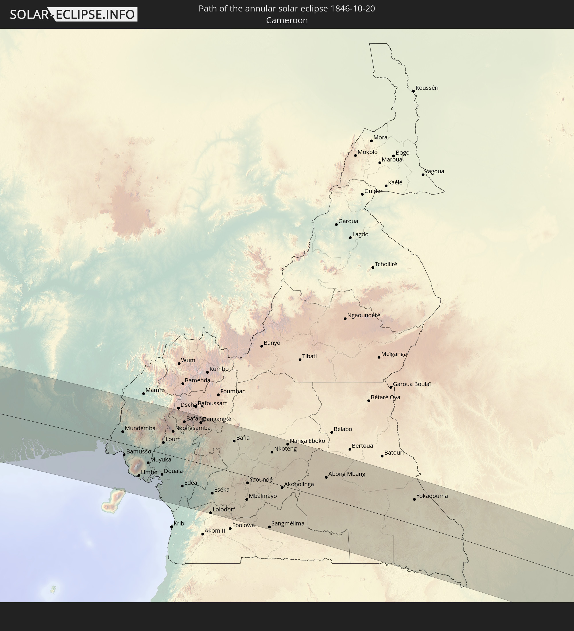
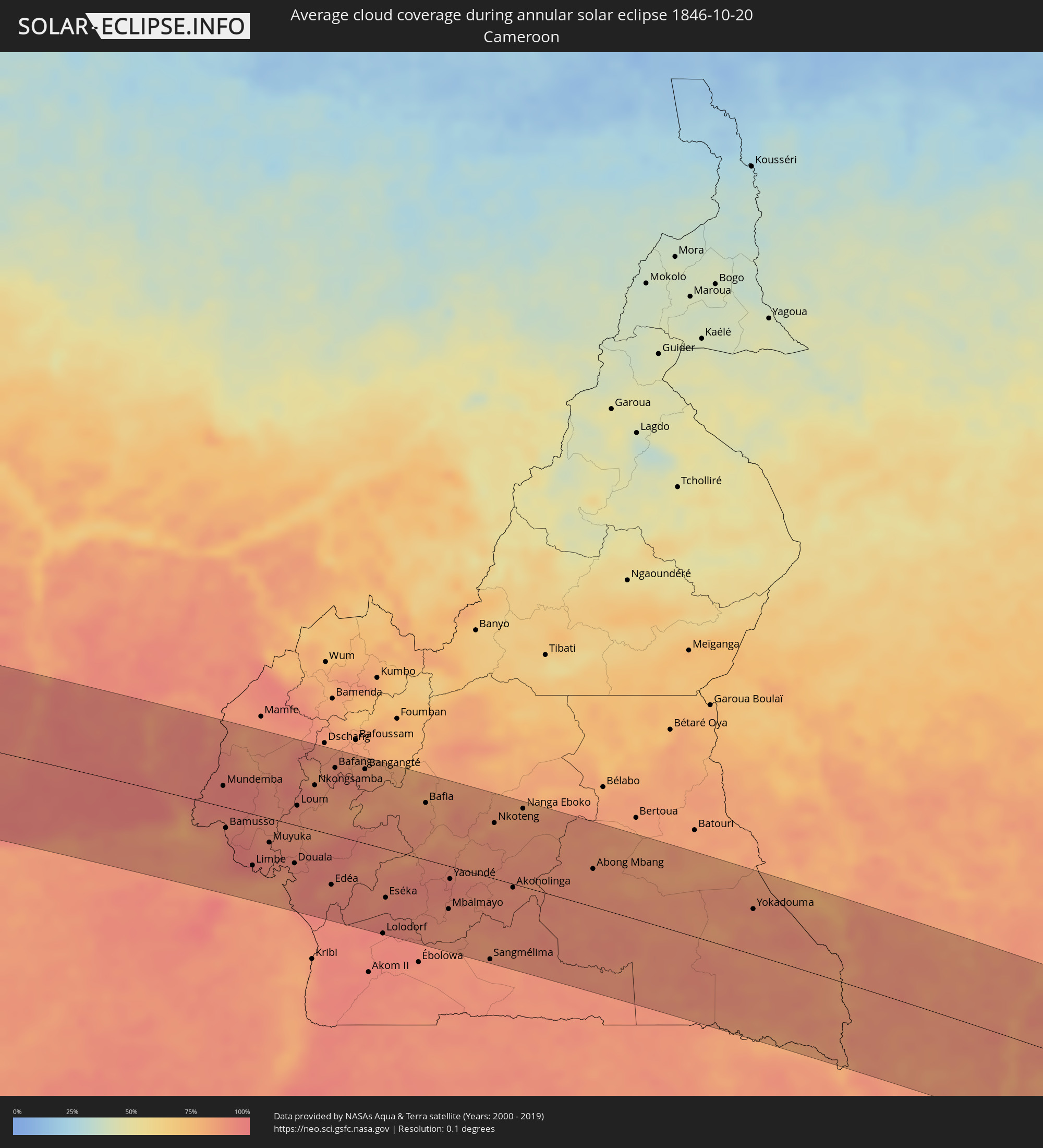 Cameroon
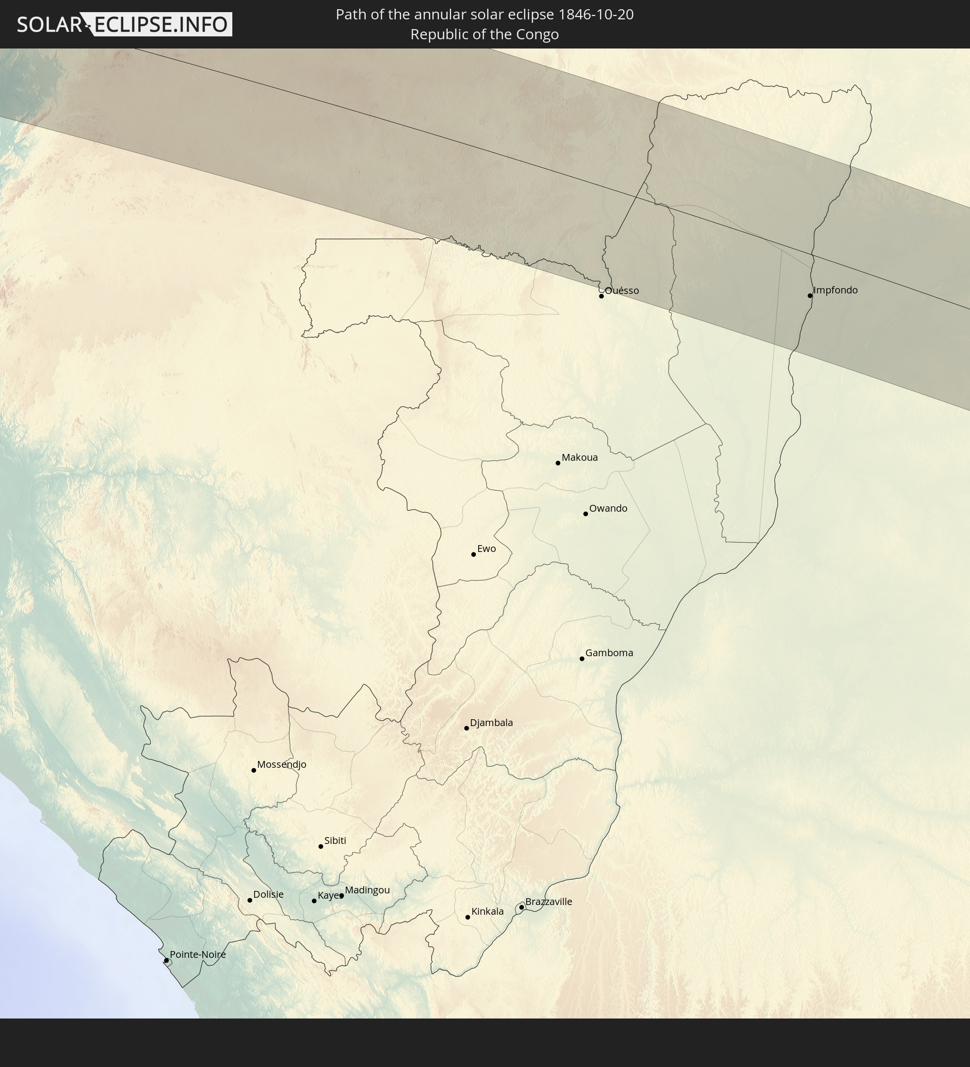
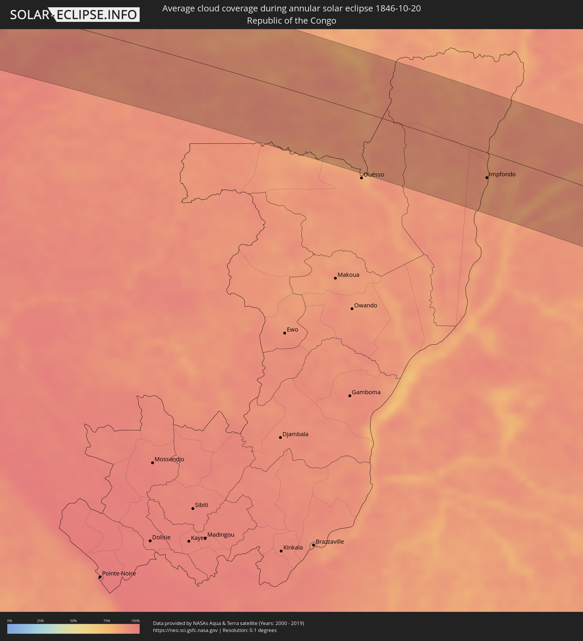 Republic of the Congo
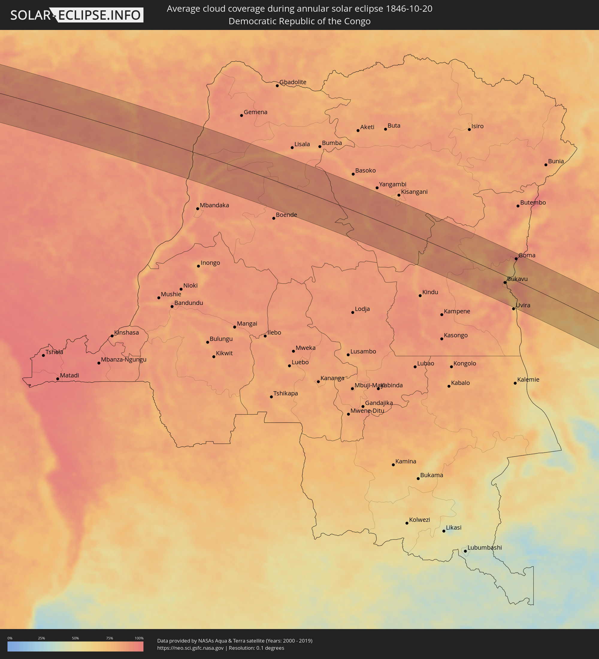 Democratic Republic of the Congo
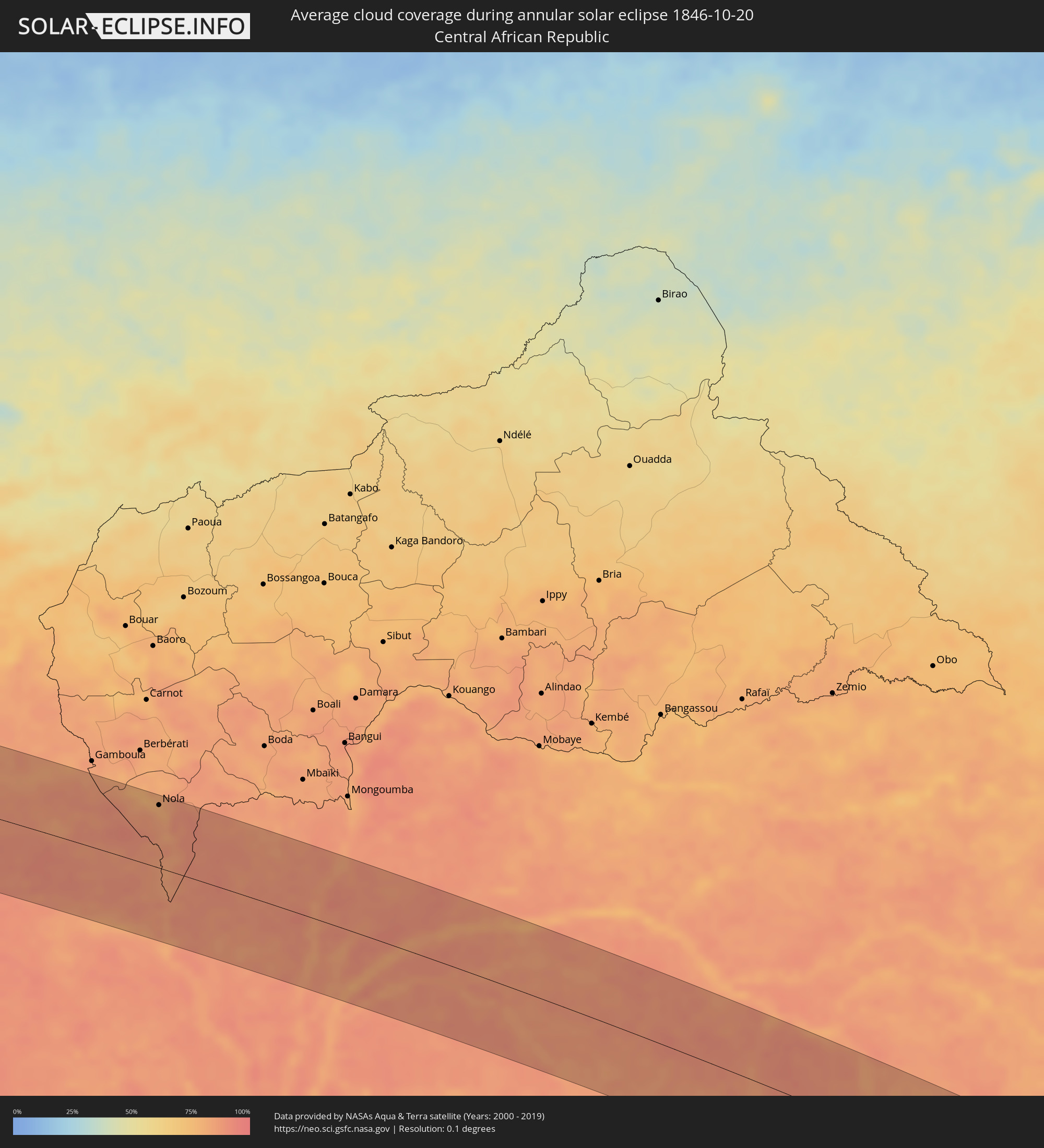 Central African Republic
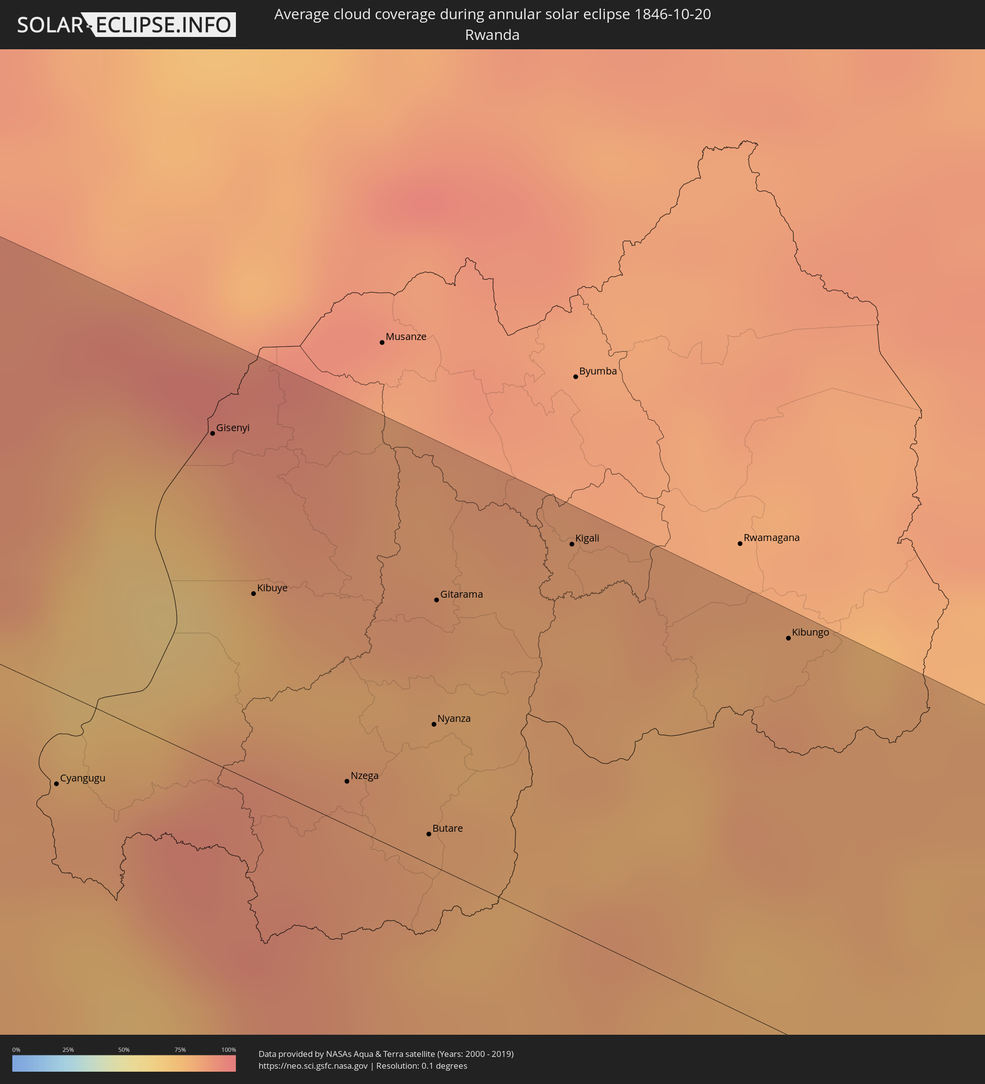 Rwanda
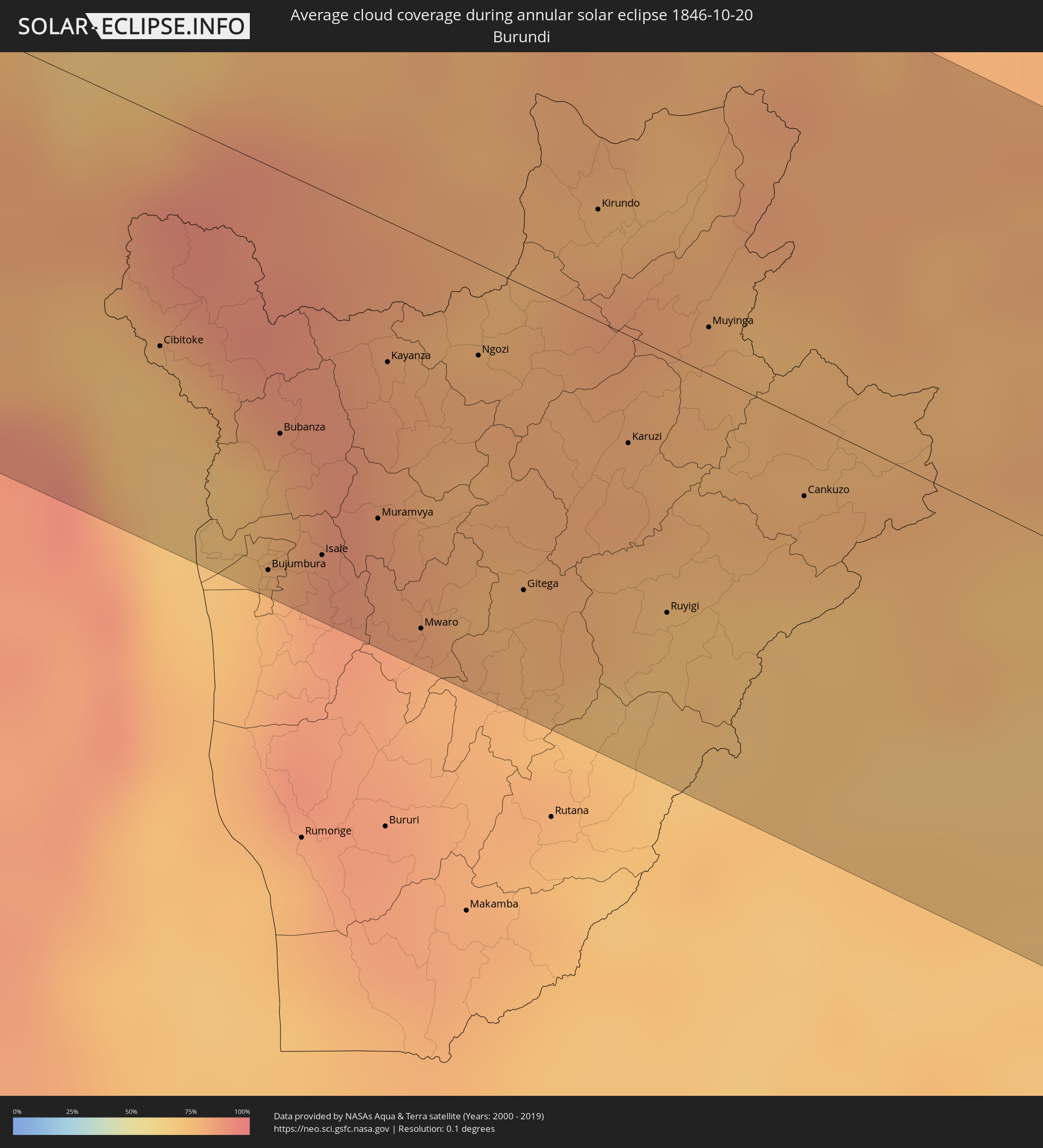 Burundi
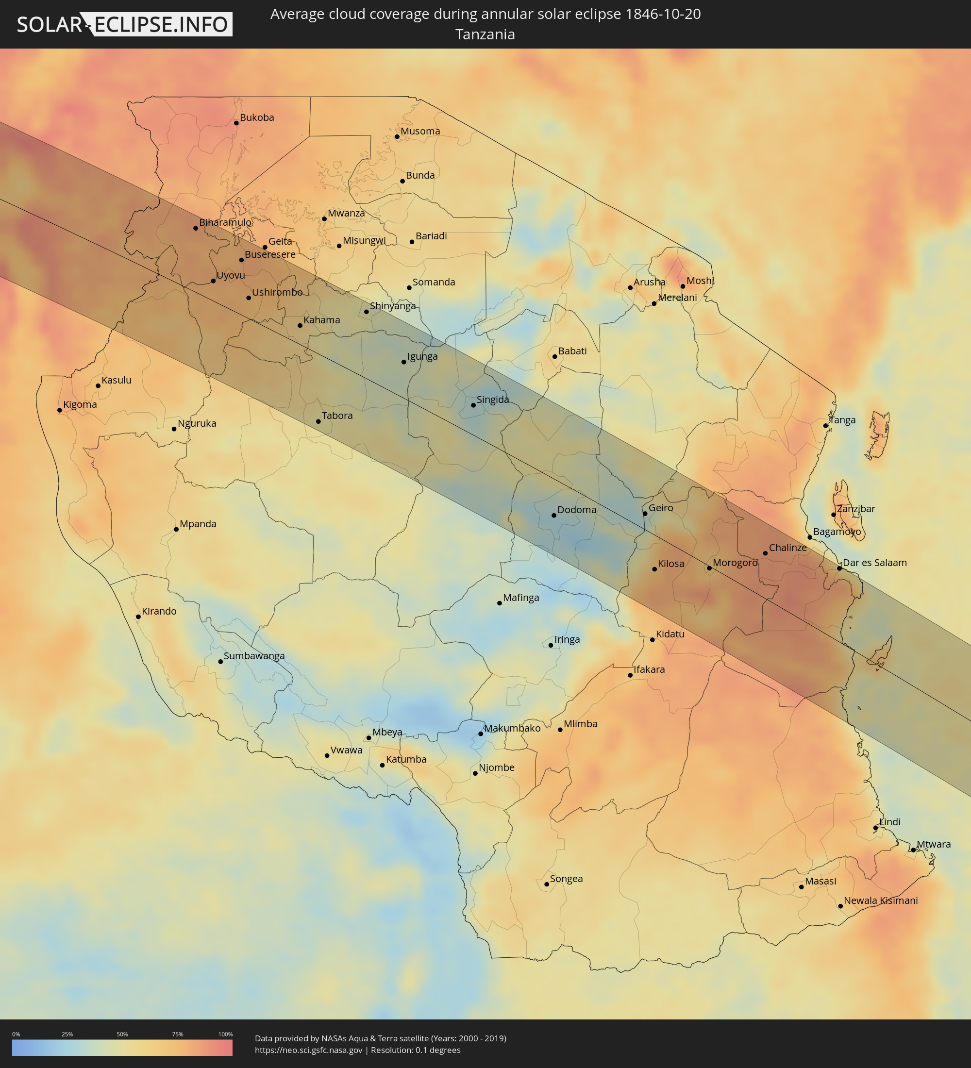 Tanzania
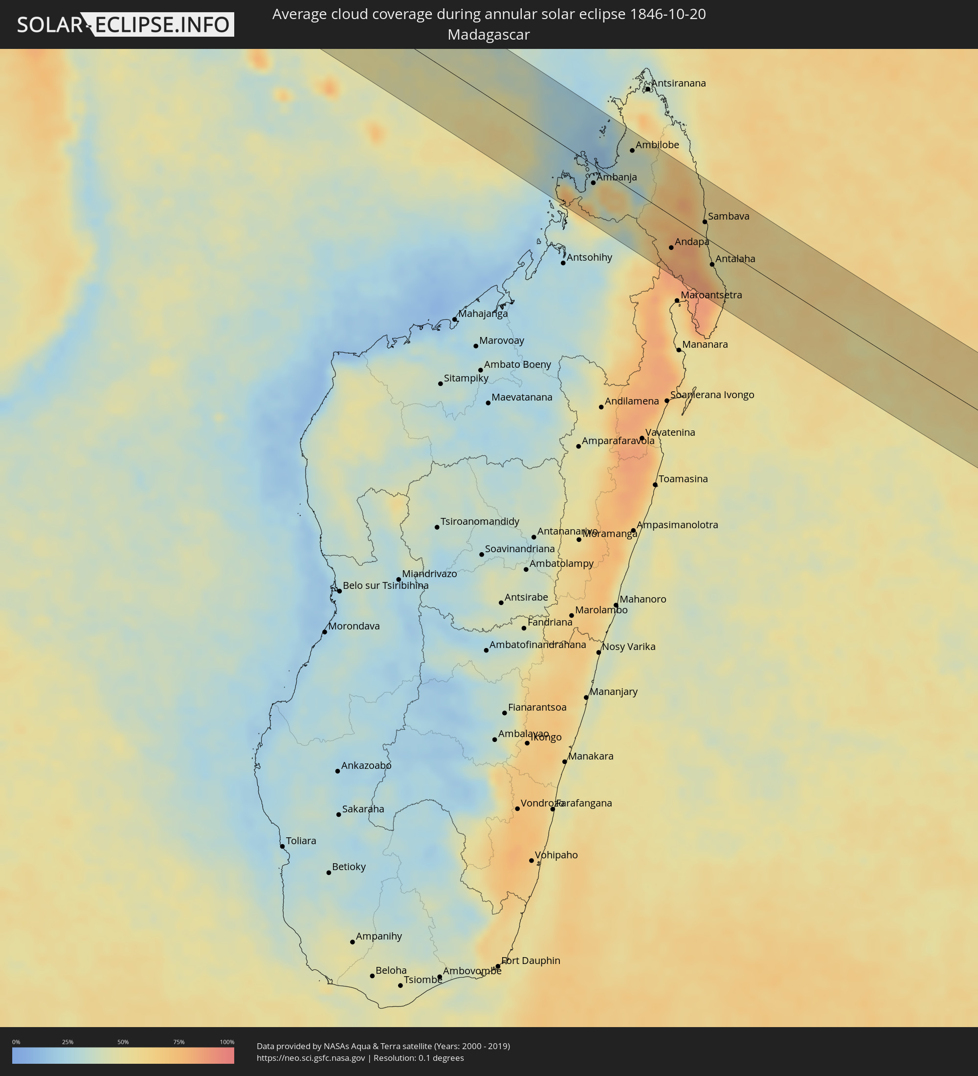 Madagascar
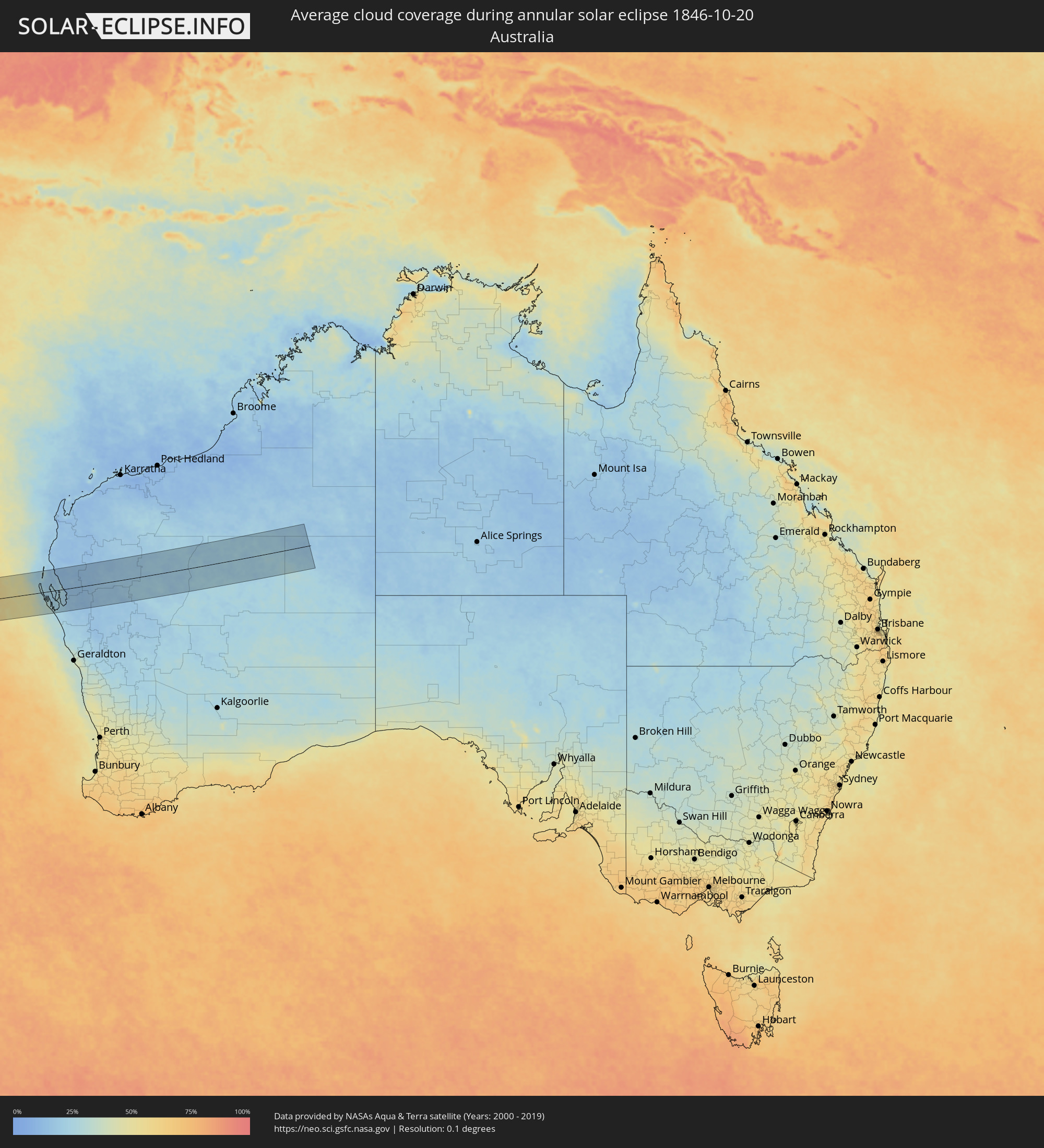 Australia
Cities inside the path of the eclipse
The following table shows all locations with a population of more than 5,000 inside the eclipse path. Cities which have more than 100,000 inhabitants are marked bold. A click at the locations opens a detailed map.
| City | Type | Eclipse duration | Local time of max. eclipse | Distance to central line | Ø Cloud coverage |
|
Akwatia, Eastern
|
annular | - | 05:51:53 UTC-00:00 | 82 km | 90% |
|
Asamankese, Eastern
|
annular | - | 05:51:57 UTC-00:00 | 98 km | 88% |
|
Suhum, Eastern
|
annular | - | 05:51:51 UTC-00:00 | 77 km | 88% |
|
Begoro, Eastern
|
annular | - | 05:51:41 UTC-00:00 | 40 km | 87% |
|
Nsawam, Eastern
|
annular | - | 05:51:58 UTC-00:00 | 98 km | 93% |
|
Achiaman, Greater Accra
|
annular | - | 05:52:01 UTC-00:00 | 109 km | 93% |
|
Koforidua, Eastern
|
annular | - | 05:51:49 UTC-00:00 | 65 km | 89% |
|
Dome, Greater Accra
|
annular | - | 05:52:02 UTC-00:00 | 113 km | 93% |
|
Aburi, Eastern
|
annular | - | 05:51:56 UTC-00:00 | 90 km | 93% |
|
Medina Estates, Greater Accra
|
annular | - | 05:52:01 UTC-00:00 | 110 km | 93% |
|
Tema, Greater Accra
|
annular | - | 05:52:01 UTC-00:00 | 106 km | 77% |
|
Kpandu, Volta
|
annular | - | 05:51:22 UTC-00:00 | 45 km | 72% |
|
Ho, Volta
|
annular | - | 05:51:32 UTC-00:00 | 6 km | 89% |
|
Hohoe, Volta
|
annular | - | 05:51:17 UTC-00:00 | 66 km | 75% |
|
Kpalimé, Plateaux
|
annular | - | 05:36:07 UTC-00:16 | 42 km | 83% |
|
Anloga, Volta
|
annular | - | 05:51:54 UTC-00:00 | 74 km | 75% |
|
Amlamé, Plateaux
|
annular | - | 05:35:51 UTC-00:16 | 109 km | 68% |
|
Notsé, Plateaux
|
annular | - | 05:36:05 UTC-00:16 | 58 km | 87% |
|
Lomé, Maritime
|
annular | - | 05:36:28 UTC-00:16 | 29 km | 71% |
|
Tsévié, Maritime
|
annular | - | 05:36:19 UTC-00:16 | 2 km | 92% |
|
Tabligbo, Maritime
|
annular | - | 05:36:14 UTC-00:16 | 25 km | 92% |
|
Vogan, Maritime
|
annular | - | 05:36:22 UTC-00:16 | 1 km | 78% |
|
Aného, Maritime
|
annular | - | 05:36:25 UTC-00:16 | 11 km | 74% |
|
Aplahoué, Kouffo
|
annular | - | 06:05:47 UTC+00:13 | 68 km | 87% |
|
Lokossa, Mono
|
annular | - | 06:05:56 UTC+00:13 | 36 km | 91% |
|
Dogbo, Kouffo
|
annular | - | 06:05:51 UTC+00:13 | 57 km | 89% |
|
Grand-Popo, Mono
|
annular | - | 06:06:06 UTC+00:13 | 1 km | 77% |
|
Comé, Mono
|
annular | - | 06:06:02 UTC+00:13 | 14 km | 82% |
|
Abomey, Zou
|
annular | - | 06:05:40 UTC+00:13 | 101 km | 92% |
|
Bohicon, Zou
|
annular | - | 06:05:40 UTC+00:13 | 103 km | 90% |
|
Ouidah, Atlantique
|
annular | - | 06:06:04 UTC+00:13 | 14 km | 80% |
|
Allada, Atlantique
|
annular | - | 06:05:55 UTC+00:13 | 48 km | 95% |
|
Hévié, Atlantique
|
annular | - | 06:06:02 UTC+00:13 | 23 km | 85% |
|
Abomey-Calavi, Atlantique
|
annular | - | 06:06:01 UTC+00:13 | 29 km | 84% |
|
Cotonou, Littoral
|
annular | - | 06:06:04 UTC+00:13 | 22 km | 84% |
|
Porto-Novo, Ouémé
|
annular | - | 06:06:00 UTC+00:13 | 40 km | 88% |
|
Sakété, Plateau
|
annular | - | 06:05:53 UTC+00:13 | 67 km | 97% |
|
Pobé, Plateau
|
annular | - | 06:05:46 UTC+00:13 | 94 km | 93% |
|
Ikeja, Lagos
|
annular | - | 06:05:58 UTC+00:13 | 67 km | 97% |
|
Lagos, Lagos
|
annular | - | 06:06:03 UTC+00:13 | 53 km | 88% |
|
Ebute Ikorodu, Lagos
|
annular | - | 06:05:58 UTC+00:13 | 71 km | 85% |
|
Shagamu, Ogun
|
annular | - | 06:05:51 UTC+00:13 | 102 km | 93% |
|
Ijebu-Ode, Ogun
|
annular | - | 06:05:53 UTC+00:13 | 105 km | 94% |
|
Benin City, Edo
|
annular | - | 06:06:16 UTC+00:13 | 93 km | 94% |
|
Warri, Delta
|
annular | - | 06:06:44 UTC+00:13 | 7 km | 95% |
|
Onitsha, Anambra
|
annular | - | 06:06:32 UTC+00:13 | 101 km | 92% |
|
Port Harcourt, Rivers
|
annular | - | 06:07:22 UTC+00:13 | 41 km | 96% |
|
Owerri, Imo
|
annular | - | 06:06:57 UTC+00:13 | 35 km | 97% |
|
Aba, Abia
|
annular | - | 06:07:14 UTC+00:13 | 3 km | 96% |
|
Umuahia, Abia
|
annular | - | 06:07:00 UTC+00:13 | 52 km | 95% |
|
Ikot Ekpene, Akwa Ibom
|
annular | - | 06:07:15 UTC+00:13 | 20 km | 96% |
|
Uyo, Akwa Ibom
|
annular | - | 06:07:22 UTC+00:13 | 12 km | 97% |
|
Calabar, Cross River
|
annular | - | 06:07:31 UTC+00:13 | 13 km | 93% |
|
Malabo, Bioko Norte
|
annular | - | 06:08:24 UTC+00:13 | 106 km | 91% |
|
Rebola, Bioko Norte
|
annular | - | 06:08:26 UTC+00:13 | 108 km | 97% |
|
Limbe, South-West
|
annular | - | 06:08:19 UTC+00:13 | 64 km | 92% |
|
Tiko, South-West
|
annular | - | 06:08:20 UTC+00:13 | 55 km | 92% |
|
Kumba, South-West
|
annular | - | 06:07:59 UTC+00:13 | 8 km | 90% |
|
Mbanga, Littoral
|
annular | - | 06:08:06 UTC+00:13 | 3 km | 89% |
|
Douala, Littoral
|
annular | - | 06:08:26 UTC+00:13 | 48 km | 91% |
|
Loum, Littoral
|
annular | - | 06:08:01 UTC+00:13 | 25 km | 90% |
|
Nkongsamba, Littoral
|
annular | - | 06:07:55 UTC+00:13 | 56 km | 91% |
|
Edéa, Littoral
|
annular | - | 06:08:44 UTC+00:13 | 63 km | 90% |
|
Bafang, West
|
annular | - | 06:07:51 UTC+00:13 | 85 km | 91% |
|
Bangangté, West
|
annular | - | 06:07:58 UTC+00:13 | 93 km | 89% |
|
Bafia, Centre
|
annular | - | 06:08:26 UTC+00:13 | 71 km | 84% |
|
Mbalmayo, Centre
|
annular | - | 06:09:22 UTC+00:13 | 54 km | 89% |
|
Yaoundé, Centre
|
annular | - | 06:09:08 UTC+00:13 | 16 km | 95% |
|
Sangmélima, South
|
annular | - | 06:09:59 UTC+00:13 | 102 km | 90% |
|
Nkoteng, Centre
|
annular | - | 06:08:52 UTC+00:13 | 69 km | 89% |
|
Nola, Sangha-Mbaéré
|
annular | - | 06:11:23 UTC+00:13 | 90 km | 81% |
|
Impfondo, Likouala
|
annular | - | 06:14:09 UTC+00:13 | 43 km | 82% |
|
Kabare, South Kivu
|
annular | - | 08:25:22 UTC+02:10 | 28 km | 82% |
|
Bukavu, South Kivu
|
annular | - | 08:25:26 UTC+02:10 | 25 km | 82% |
|
Cyangugu, Western Province
|
annular | - | 08:25:30 UTC+02:10 | 21 km | 82% |
|
Sake, Nord Kivu
|
annular | - | 08:24:31 UTC+02:10 | 77 km | 79% |
|
Cibitoke, Cibitoke
|
annular | - | 08:26:18 UTC+02:10 | 52 km | 71% |
|
Goma, Nord Kivu
|
annular | - | 08:24:53 UTC+02:10 | 76 km | 78% |
|
Gisenyi, Western Province
|
annular | - | 08:24:57 UTC+02:10 | 74 km | 85% |
|
Kibuye, Western Province
|
annular | - | 08:25:31 UTC+02:10 | 42 km | 77% |
|
Bujumbura, Bujumbura Mairie
|
annular | - | 08:27:15 UTC+02:10 | 90 km | 82% |
|
Bubanza, Bubanza
|
annular | - | 08:26:53 UTC+02:10 | 59 km | 80% |
|
Isale, Bujumbura Rural
|
annular | - | 08:27:22 UTC+02:10 | 81 km | 88% |
|
Nzega, Southern Province
|
annular | - | 08:26:19 UTC+02:10 | 10 km | 84% |
|
Muramvya, Muramvya
|
annular | - | 08:27:25 UTC+02:10 | 67 km | 84% |
|
Kayanza, Kayanza
|
annular | - | 08:26:59 UTC+02:10 | 31 km | 84% |
|
Mwaro, Mwaro
|
annular | - | 08:27:52 UTC+02:10 | 87 km | 79% |
|
Butare, Southern Province
|
annular | - | 08:26:42 UTC+02:10 | 7 km | 82% |
|
Nyanza, Southern Province
|
annular | - | 08:26:24 UTC+02:10 | 32 km | 80% |
|
Gitarama, Southern Province
|
annular | - | 08:26:03 UTC+02:10 | 60 km | 77% |
|
Ngozi, Ngozi
|
annular | - | 08:27:14 UTC+02:10 | 20 km | 80% |
|
Gitega, Gitega
|
annular | - | 08:28:03 UTC+02:10 | 68 km | 77% |
|
Kigali, Kigali
|
annular | - | 08:26:17 UTC+02:10 | 87 km | 81% |
|
Kirundo, Kirundo
|
annular | - | 08:27:09 UTC+02:10 | 25 km | 83% |
|
Karuzi, Karuzi
|
annular | - | 08:27:56 UTC+02:10 | 24 km | 80% |
|
Ruyigi, Ruyigi
|
annular | - | 08:28:33 UTC+02:10 | 57 km | 71% |
|
Muyinga, Muyinga
|
annular | - | 08:27:49 UTC+02:10 | 10 km | 78% |
|
Kibungo, Eastern Province
|
annular | - | 08:27:12 UTC+02:10 | 89 km | 84% |
|
Cankuzo, Cankuzo
|
annular | - | 08:28:37 UTC+02:10 | 17 km | 77% |
|
Uyovu, Geita
|
annular | - | 08:46:58 UTC+02:27 | 24 km | 75% |
|
Buseresere, Geita
|
annular | - | 08:47:07 UTC+02:27 | 67 km | 80% |
|
Ushirombo, Geita
|
annular | - | 08:47:53 UTC+02:27 | 25 km | 72% |
|
Masumbwe, Geita
|
annular | - | 08:48:24 UTC+02:27 | 22 km | 67% |
|
Kahama, Shinyanga
|
annular | - | 08:49:18 UTC+02:27 | 23 km | 57% |
|
Tabora, Tabora
|
annular | - | 08:51:21 UTC+02:27 | 83 km | 50% |
|
Shinyanga, Shinyanga
|
annular | - | 08:50:17 UTC+02:27 | 81 km | 45% |
|
Igunga, Tabora
|
annular | - | 08:51:54 UTC+02:27 | 44 km | 41% |
|
Singida, Singida
|
annular | - | 08:54:04 UTC+02:27 | 36 km | 30% |
|
Dodoma, Dodoma
|
annular | - | 08:57:49 UTC+02:27 | 44 km | 28% |
|
Geiro, Morogoro
|
annular | - | 08:59:46 UTC+02:27 | 19 km | 44% |
|
Kilosa, Morogoro
|
annular | - | 09:01:05 UTC+02:27 | 41 km | 75% |
|
Morogoro, Morogoro
|
annular | - | 09:02:18 UTC+02:27 | 3 km | 74% |
|
Chalinze, Pwani
|
annular | - | 09:03:17 UTC+02:27 | 53 km | 86% |
|
Dar es Salaam, Dar es Salaam
|
annular | - | 09:05:20 UTC+02:27 | 86 km | 65% |
|
Hell-Ville, Diana
|
annular | - | 09:37:58 UTC+02:27 | 10 km | 29% |
|
Ambanja, Diana
|
annular | - | 09:38:59 UTC+02:27 | 25 km | 51% |
|
Antsohimbondrona, Diana
|
annular | - | 09:38:52 UTC+02:27 | 54 km | 35% |
|
Ambarakaraka, Diana
|
annular | - | 09:39:43 UTC+02:27 | 16 km | 39% |
|
Ambilobe, Diana
|
annular | - | 09:39:37 UTC+02:27 | 55 km | 36% |
|
Andapa, Sava
|
annular | - | 09:44:02 UTC+02:27 | 45 km | 80% |
|
Ambodivoara, Sava
|
annular | - | 09:44:19 UTC+02:27 | 4 km | 70% |
|
Sambava, Sava
|
annular | - | 09:44:40 UTC+02:27 | 21 km | 51% |
|
Ampahana, Sava
|
annular | - | 09:45:45 UTC+02:27 | 21 km | 61% |
|
Antalaha, Sava
|
annular | - | 09:46:13 UTC+02:27 | 32 km | 55% |
|
Carnarvon, Western Australia
|
annular | - | 17:37:41 UTC+08:00 | 102 km | 15% |