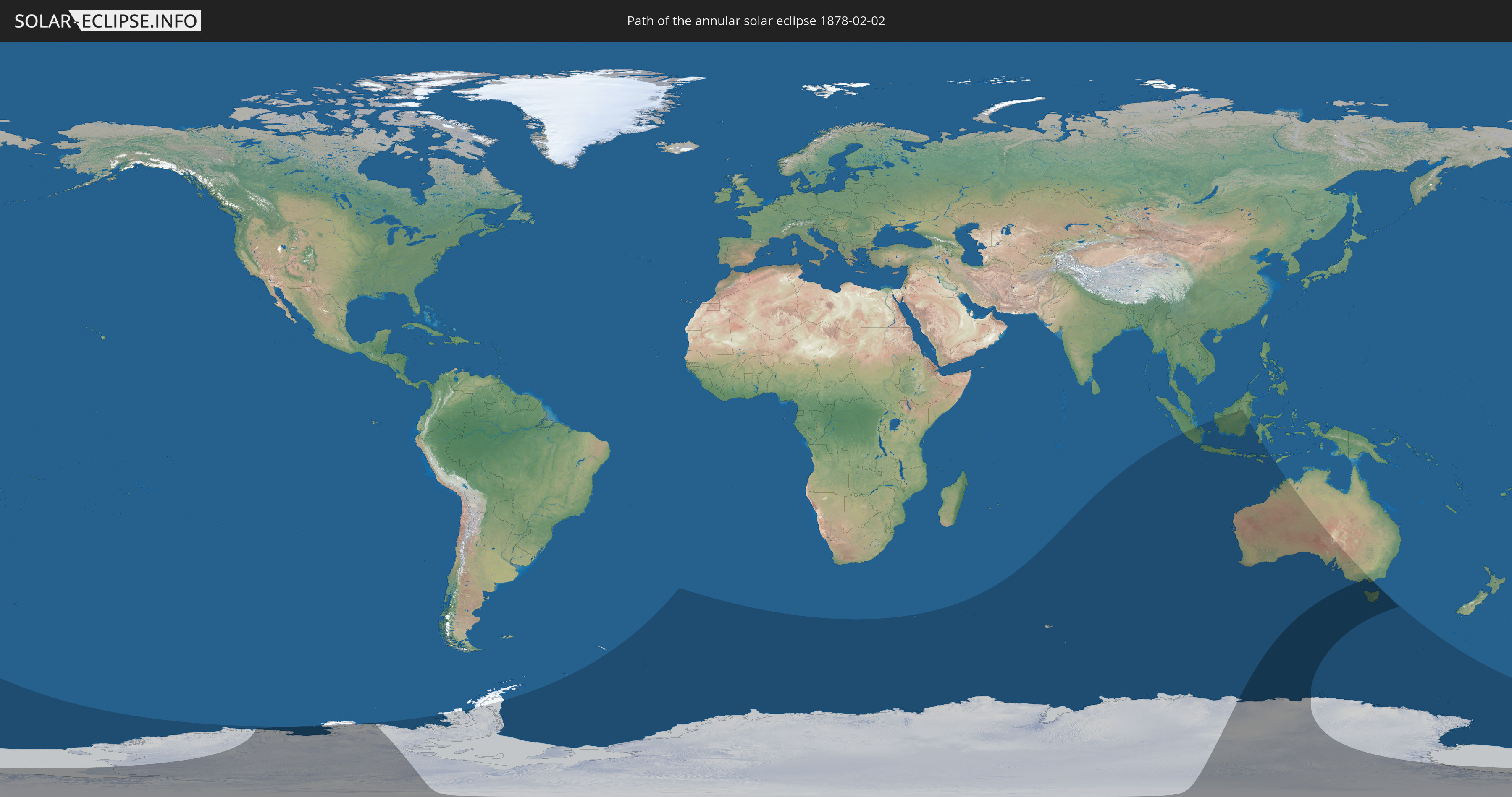
Annular solar eclipse of 02/02/1878
| Day of week: | Saturday |
| Maximum duration of eclipse: | 05m59s |
| Maximum width of eclipse path: | 729 km |
| Saros cycle: | 119 |
| Coverage: | 91.9% |
| Magnitude: | 0.9191 |
| Gamma: | -0.9071 |
Wo kann man die Sonnenfinsternis vom 02/02/1878 sehen?
Die Sonnenfinsternis am 02/02/1878 kann man in 10 Ländern als partielle Sonnenfinsternis beobachten.
Der Finsternispfad verläuft durch 2 Länder. Nur in diesen Ländern ist sie als annular Sonnenfinsternis zu sehen.
In den folgenden Ländern ist die Sonnenfinsternis annular zu sehen
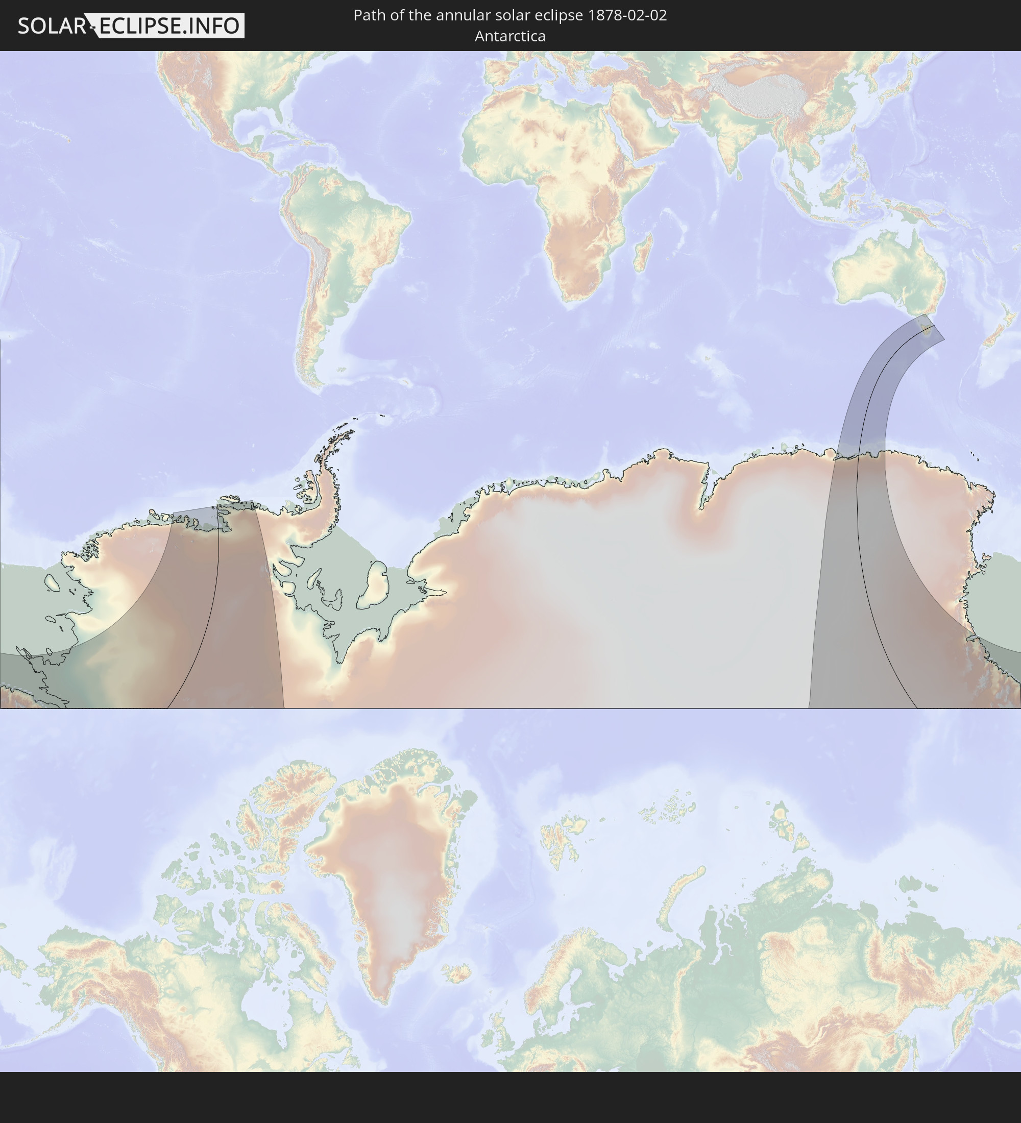 Antarctica
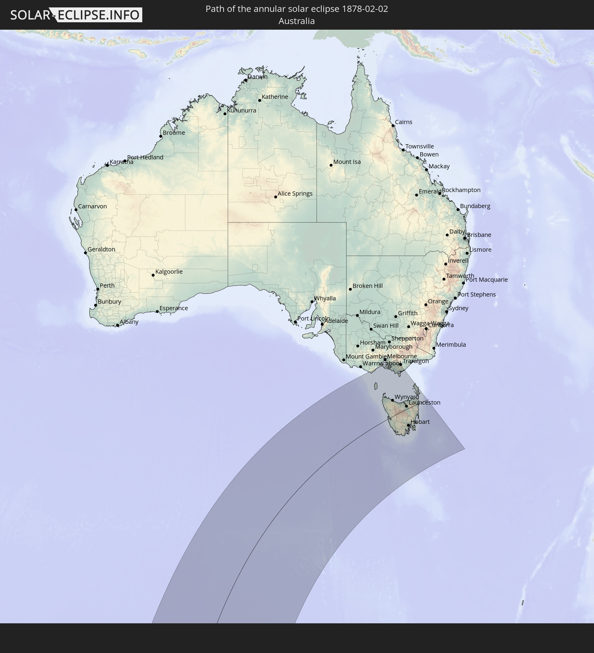 Australia
In den folgenden Ländern ist die Sonnenfinsternis partiell zu sehen


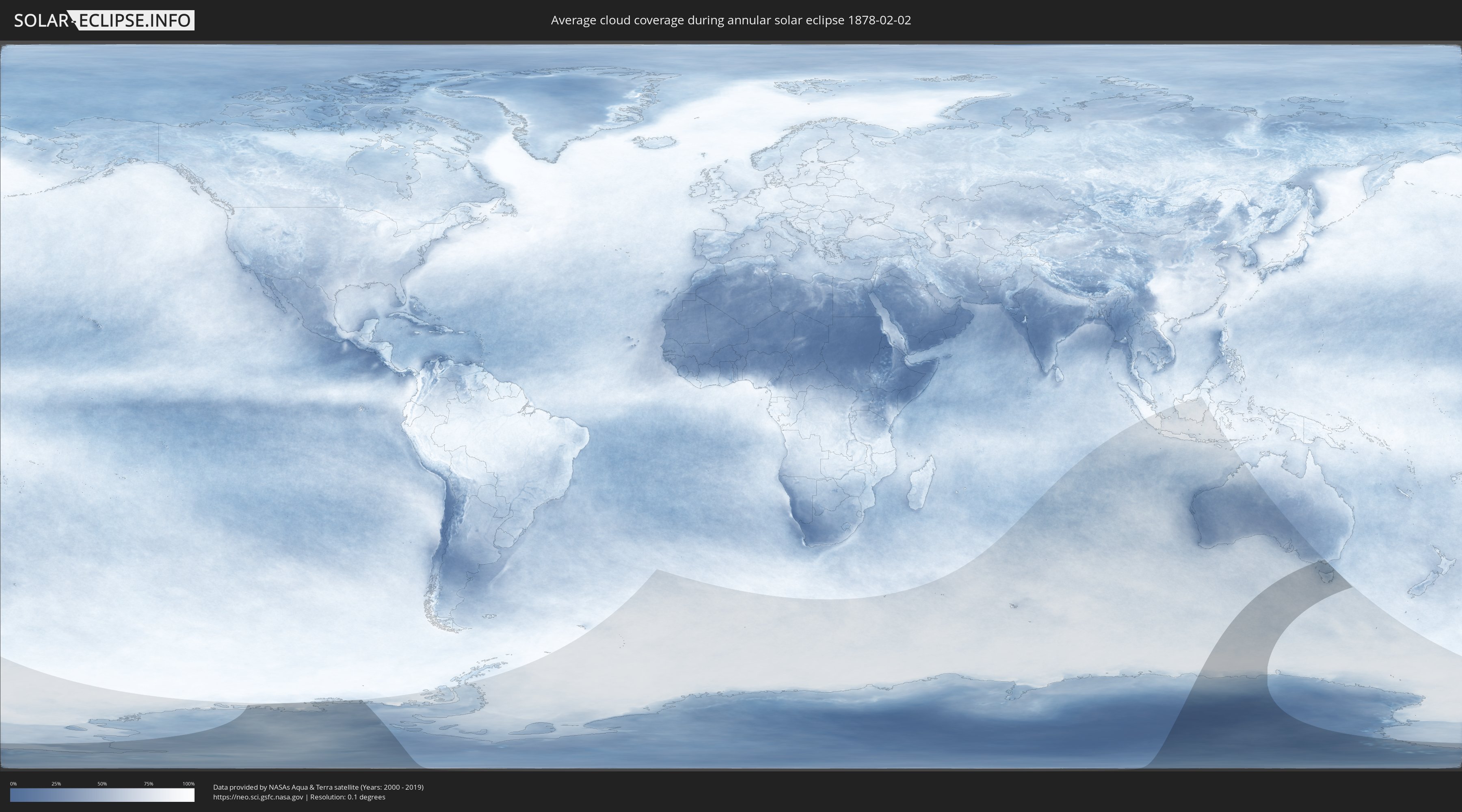
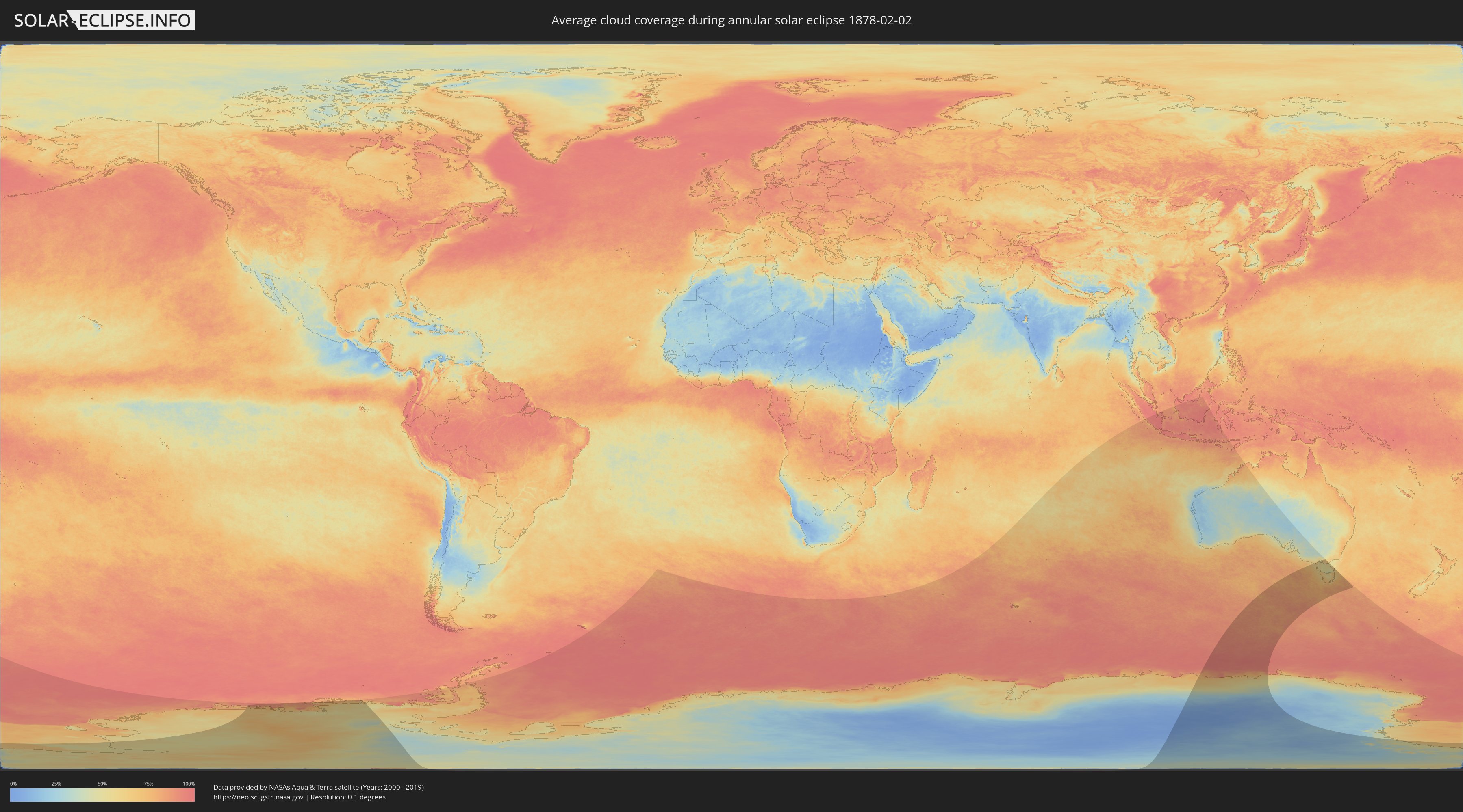
How will be the weather during the annular solar eclipse on 02/02/1878?
Where is the best place to see the annular solar eclipse of 02/02/1878?
The following maps show the average cloud coverage for the day of the annular solar eclipse.
With the help of these maps, it is possible to find the place along the eclipse path, which has the best
chance of a cloudless sky.
Nevertheless, you should consider local circumstances and inform about the weather of your chosen
observation site.
The data is provided by NASAs satellites
AQUA and TERRA.
The cloud maps are averaged over a period of 19 years (2000 - 2019).
Detailed country maps
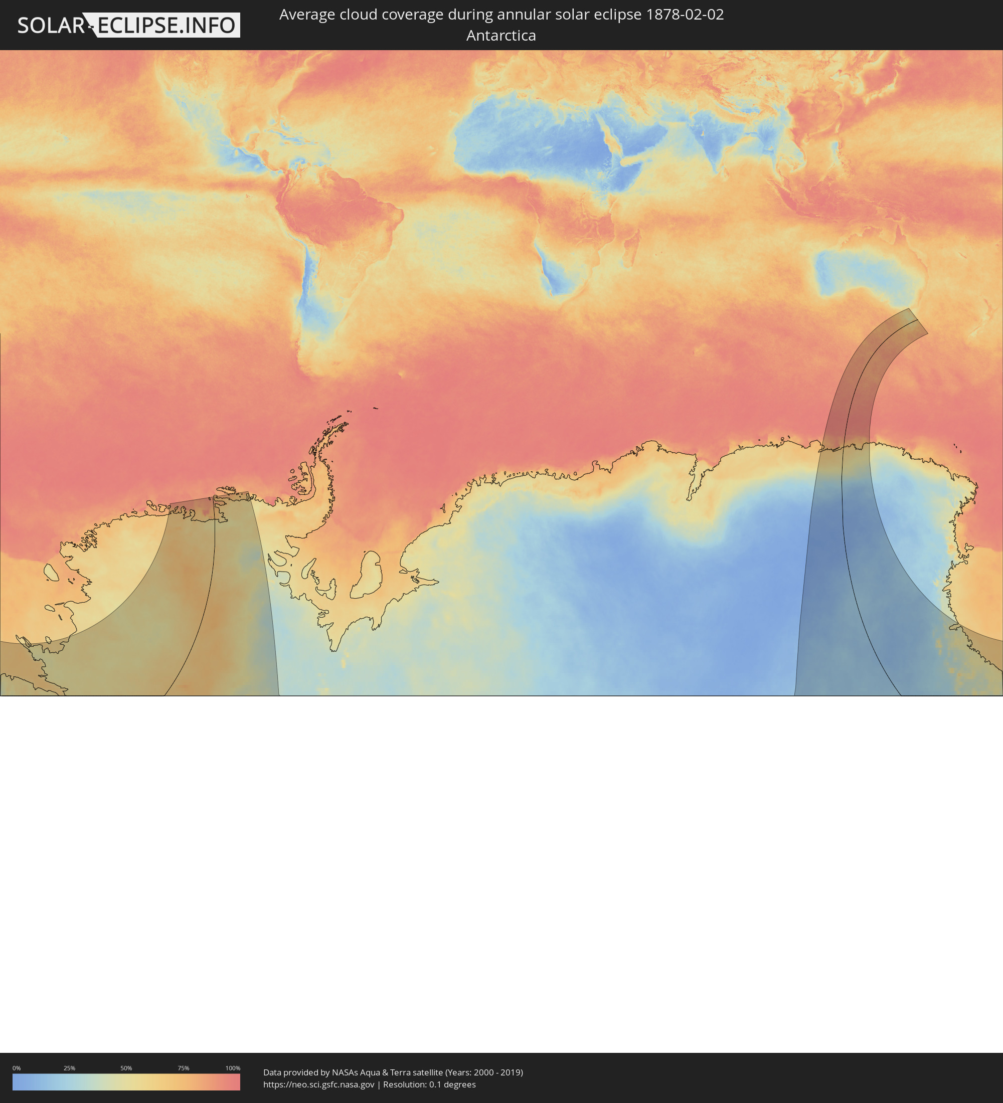 Antarctica
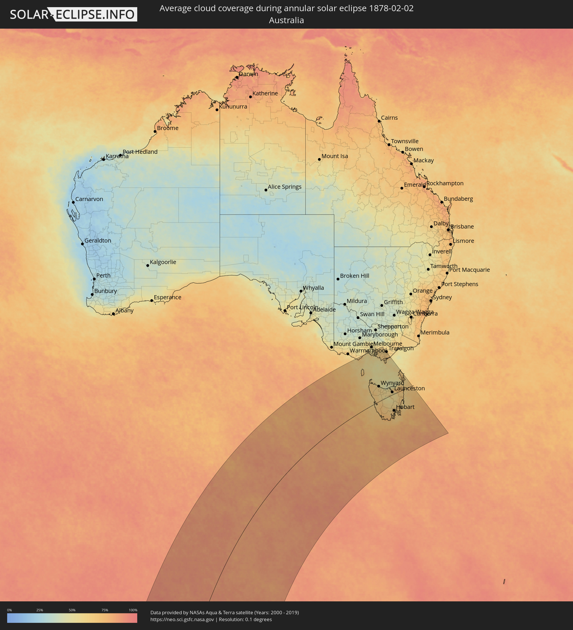 Australia
Cities inside the path of the eclipse
The following table shows all locations with a population of more than 5,000 inside the eclipse path. Cities which have more than 100,000 inhabitants are marked bold. A click at the locations opens a detailed map.
| City | Type | Eclipse duration | Local time of max. eclipse | Distance to central line | Ø Cloud coverage |
 Rye, Victoria
|
annular | - | 19:23:12 UTC+10:00 | 415 km | 56% |
|
Rosebud, Victoria
|
annular | - | 19:23:11 UTC+10:00 | 413 km | 59% |
|
Dromana, Victoria
|
annular | - | 19:23:11 UTC+10:00 | 413 km | 58% |
|
Mount Martha, Victoria
|
annular | - | 19:23:16 UTC+10:00 | 418 km | 58% |
|
Mornington, Victoria
|
annular | - | 19:23:20 UTC+10:00 | 422 km | 54% |
|
Mount Eliza, Victoria
|
annular | - | 19:23:22 UTC+10:00 | 424 km | 57% |
|
Frankston, Victoria
|
annular | - | 19:23:25 UTC+10:00 | 427 km | 56% |
|
Frankston East, Victoria
|
annular | - | 19:23:25 UTC+10:00 | 427 km | 56% |
|
Seaford, Victoria
|
partial | - | 19:23:28 UTC+10:00 | 431 km | 56% |
|
Frankston South, Victoria
|
annular | - | 19:23:22 UTC+10:00 | 424 km | 57% |
|
Frankston North, Victoria
|
annular | - | 19:23:26 UTC+10:00 | 428 km | 56% |
|
Langwarrin, Victoria
|
annular | - | 19:23:21 UTC+10:00 | 423 km | 56% |
|
Somerville, Victoria
|
annular | - | 19:23:17 UTC+10:00 | 418 km | 56% |
|
Carrum Downs, Victoria
|
annular | - | 19:23:27 UTC+10:00 | 429 km | 57% |
|
Hastings, Victoria
|
annular | - | 19:23:08 UTC+10:00 | 409 km | 58% |
|
Skye, Victoria
|
annular | - | 19:23:26 UTC+10:00 | 427 km | 57% |
|
Phillip Island, Victoria
|
annular | - | 19:22:50 UTC+10:00 | 388 km | 54% |
|
Lynbrook, Victoria
|
partial | - | 19:23:29 UTC+10:00 | 431 km | 59% |
|
Cranbourne West, Victoria
|
annular | - | 19:23:25 UTC+10:00 | 426 km | 59% |
|
Cranbourne North, Victoria
|
annular | - | 19:23:26 UTC+10:00 | 427 km | 59% |
|
Cranbourne, Victoria
|
annular | - | 19:23:23 UTC+10:00 | 424 km | 59% |
|
Cranbourne, Victoria
|
annular | - | 19:23:24 UTC+10:00 | 425 km | 59% |
|
Narre Warren South, Victoria
|
partial | - | 19:23:29 UTC+10:00 | 431 km | 60% |
|
Cranbourne East, Victoria
|
annular | - | 19:23:22 UTC+10:00 | 423 km | 59% |
|
Berwick, Victoria
|
partial | - | 19:23:29 UTC+10:00 | 430 km | 62% |
|
Pakenham South, Victoria
|
annular | - | 19:23:14 UTC+10:00 | 414 km | 62% |
|
North Wonthaggi, Victoria
|
annular | - | 19:22:29 UTC+10:00 | 363 km | 56% |
|
Wynyard, Tasmania
|
annular | - | 19:18:38 UTC+10:00 | 118 km | 61% |
|
Burnie, Tasmania
|
annular | - | 19:18:27 UTC+10:00 | 105 km | 60% |
|
Warragul, Victoria
|
annular | - | 19:23:00 UTC+10:00 | 396 km | 62% |
|
Ulverstone, Tasmania
|
annular | - | 19:18:09 UTC+10:00 | 84 km | 58% |
|
Moe, Victoria
|
annular | - | 19:22:49 UTC+10:00 | 383 km | 63% |
|
Devonport, Tasmania
|
annular | - | 19:18:03 UTC+10:00 | 76 km | 53% |
|
Morwell, Victoria
|
annular | - | 19:22:40 UTC+10:00 | 373 km | 64% |
|
New Norfolk, Tasmania
|
annular | - | 19:15:09 UTC+10:00 | 110 km | 66% |
|
Newnham, Tasmania
|
annular | - | 19:17:22 UTC+10:00 | 26 km | 56% |
|
Launceston, Tasmania
|
annular | - | 19:17:17 UTC+10:00 | 22 km | 56% |
|
Bridgewater, Tasmania
|
annular | - | 19:15:09 UTC+10:00 | 111 km | 62% |
|
Claremont, Tasmania
|
annular | - | 19:15:04 UTC+10:00 | 117 km | 64% |
|
Glenorchy, Tasmania
|
annular | - | 19:14:59 UTC+10:00 | 123 km | 64% |
|
West Moonah, Tasmania
|
annular | - | 19:14:57 UTC+10:00 | 125 km | 64% |
|
Moonah, Tasmania
|
annular | - | 19:14:57 UTC+10:00 | 125 km | 64% |
|
Kingston, Tasmania
|
annular | - | 19:14:44 UTC+10:00 | 138 km | 64% |
|
New Town, Tasmania
|
annular | - | 19:14:56 UTC+10:00 | 126 km | 66% |
|
Blackmans Bay, Tasmania
|
annular | - | 19:14:41 UTC+10:00 | 141 km | 64% |
|
Sandy Bay, Tasmania
|
annular | - | 19:14:52 UTC+10:00 | 131 km | 66% |
|
Hobart, Tasmania
|
annular | - | 19:14:53 UTC+10:00 | 129 km | 66% |
|
Lindisfarne, Tasmania
|
annular | - | 19:14:55 UTC+10:00 | 127 km | 65% |
|
Howrah, Tasmania
|
annular | - | 19:14:50 UTC+10:00 | 133 km | 67% |