Total solar eclipse of 07/29/1878
| Day of week: | Monday |
| Maximum duration of eclipse: | 03m11s |
| Maximum width of eclipse path: | 191 km |
| Saros cycle: | 124 |
| Coverage: | 100% |
| Magnitude: | 1.045 |
| Gamma: | 0.6232 |
Wo kann man die Sonnenfinsternis vom 07/29/1878 sehen?
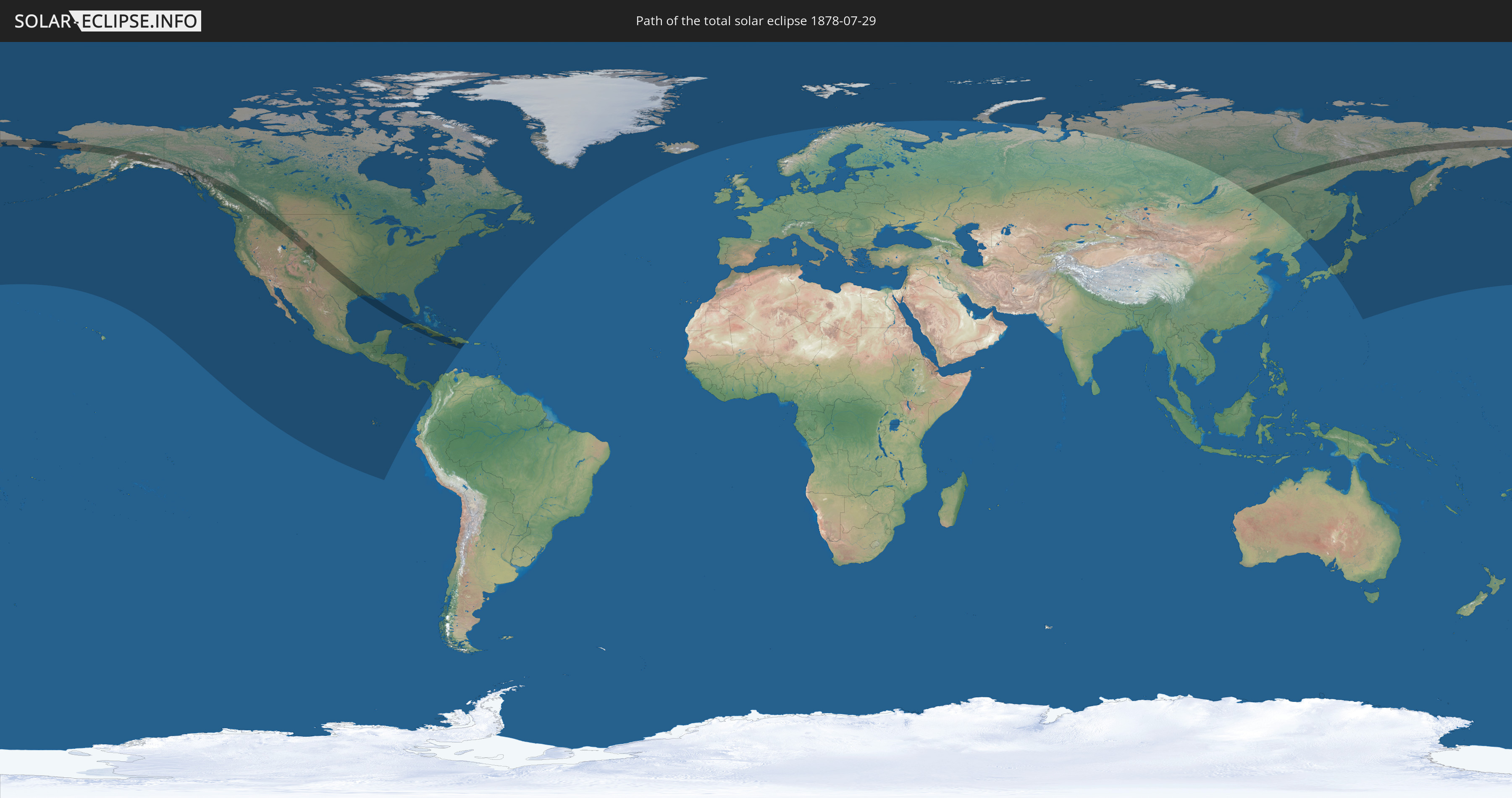
Die Sonnenfinsternis am 07/29/1878 kann man in 29 Ländern als partielle Sonnenfinsternis beobachten.
Der Finsternispfad verläuft durch 6 Länder. Nur in diesen Ländern ist sie als total Sonnenfinsternis zu sehen.
In den folgenden Ländern ist die Sonnenfinsternis total zu sehen
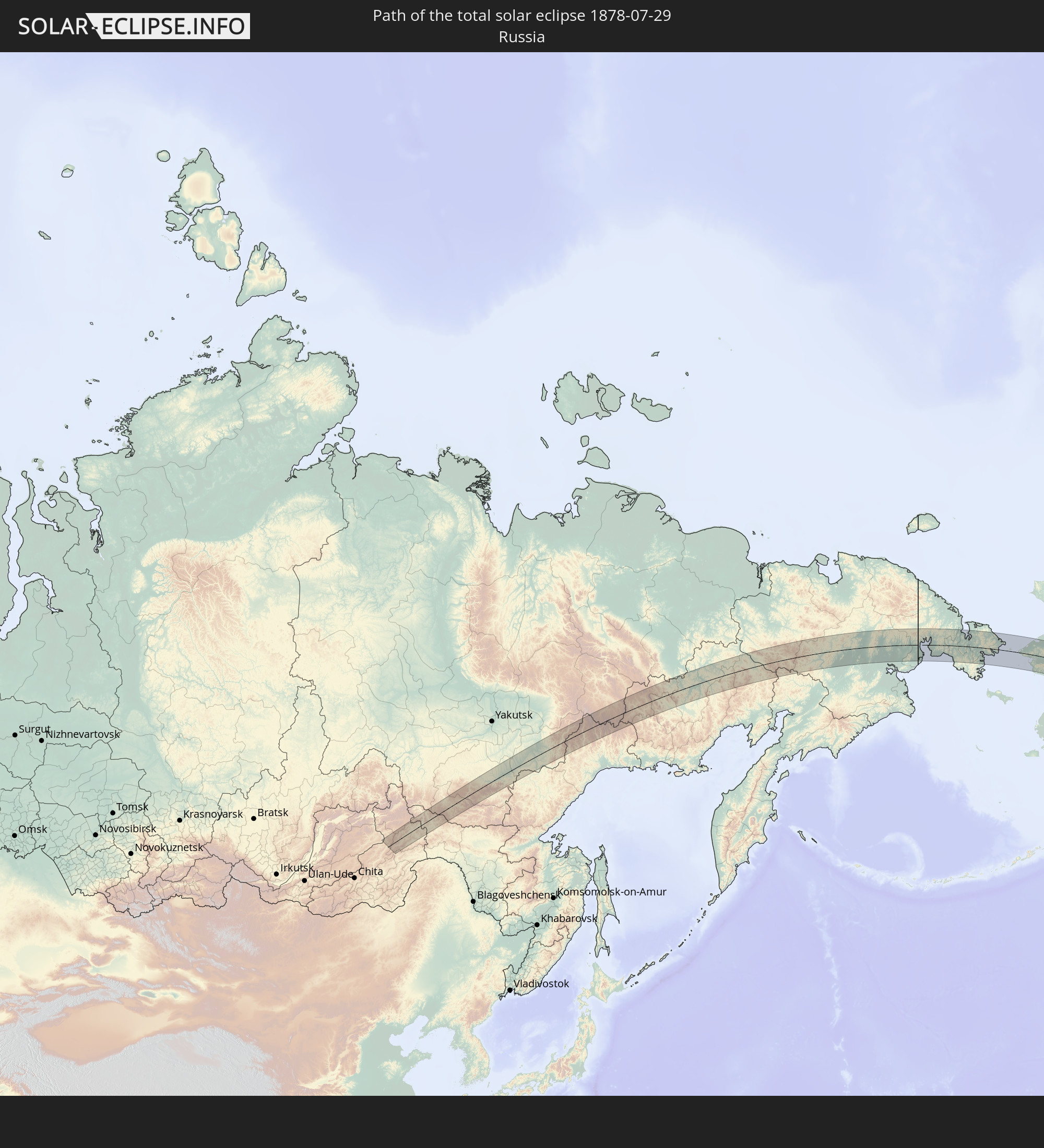 Russia
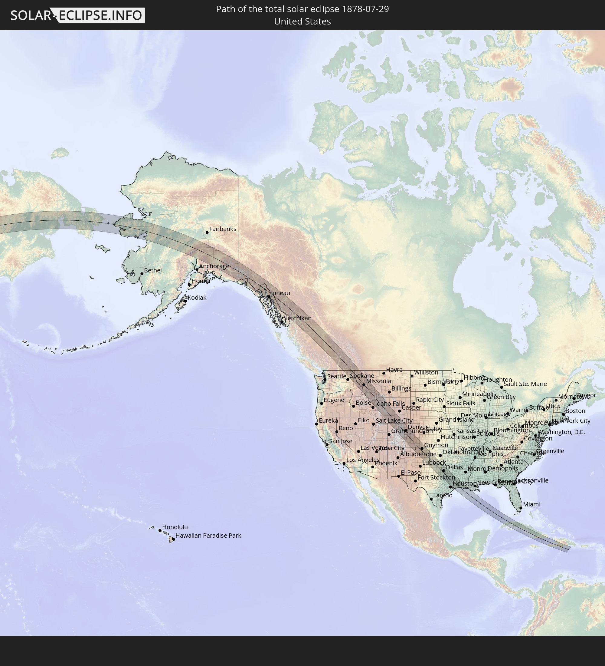 United States
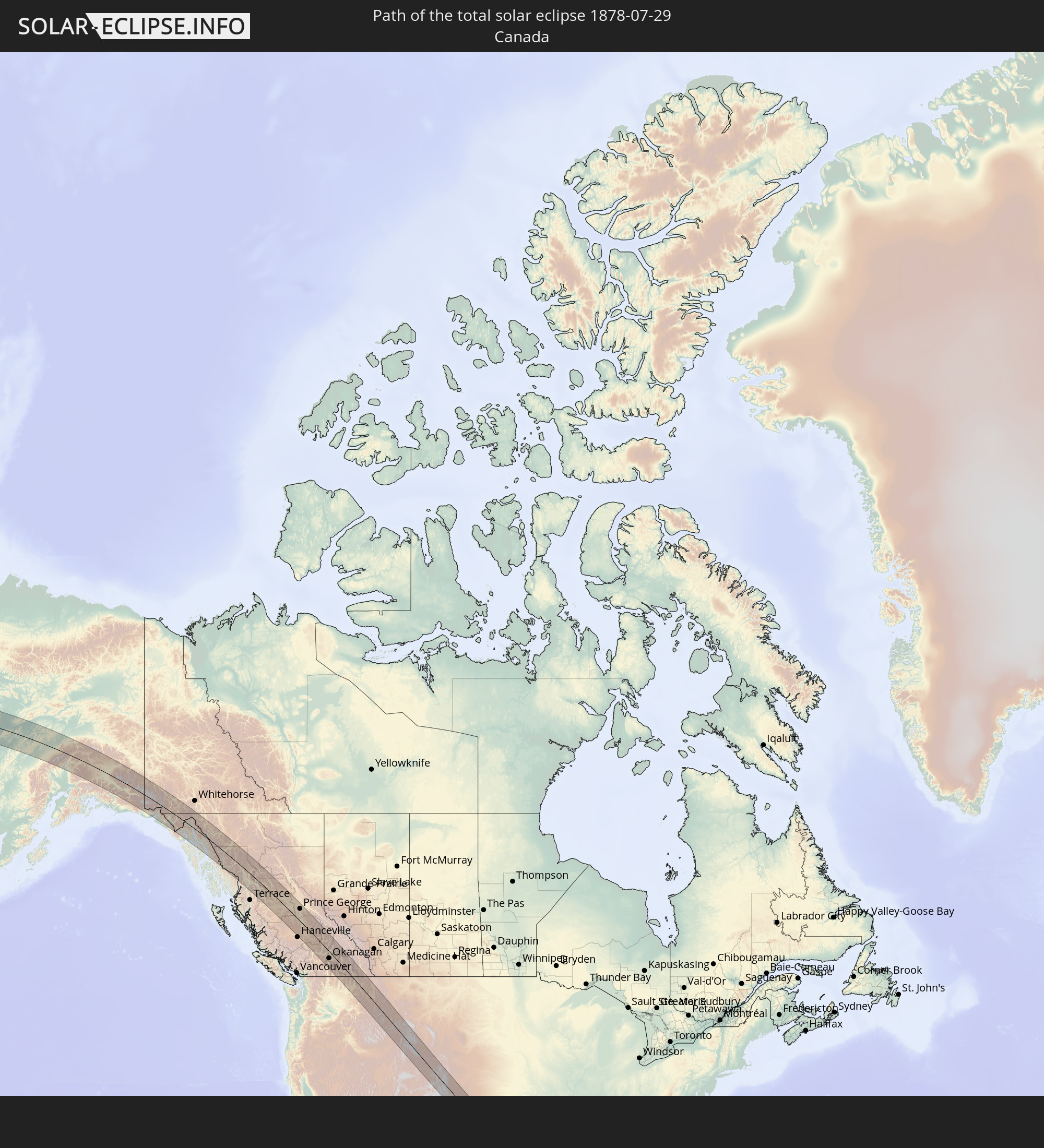 Canada
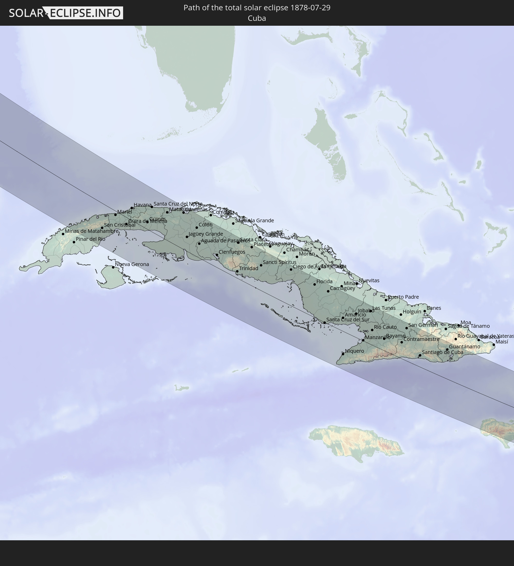 Cuba
Cuba
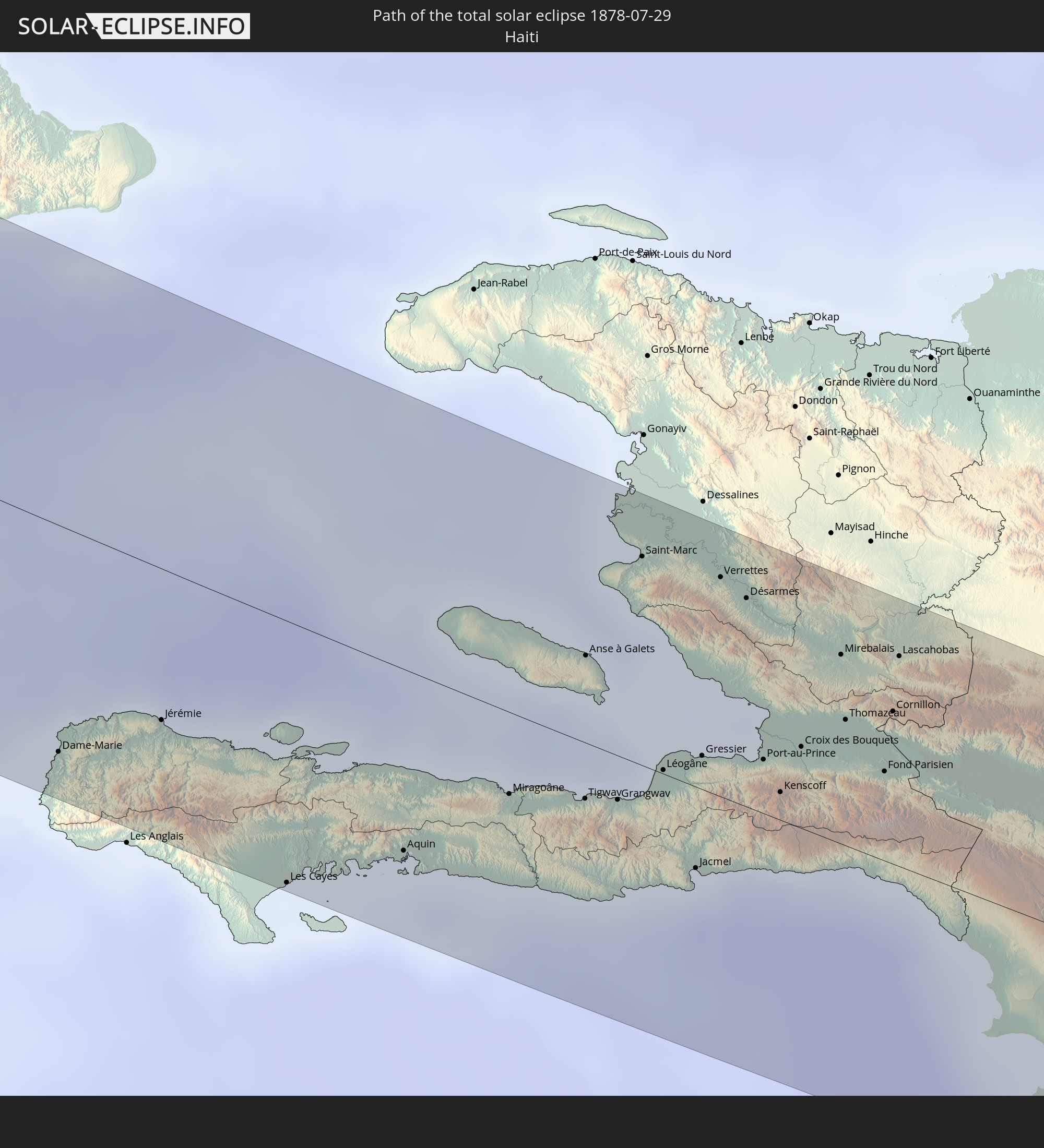 Haiti
Haiti
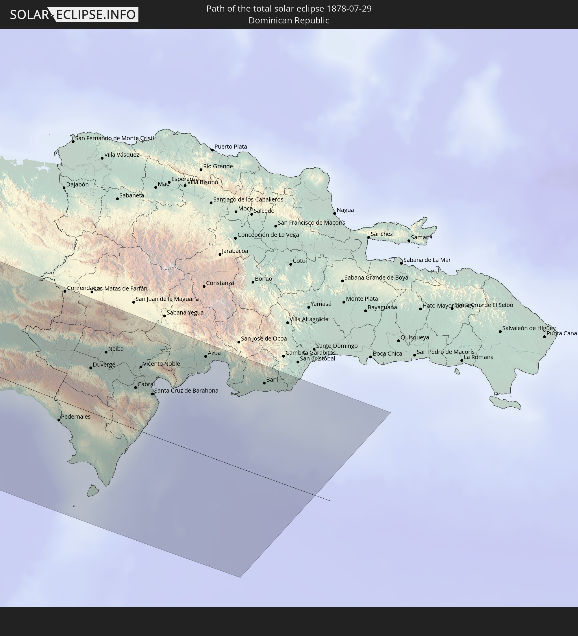 Dominican Republic
In den folgenden Ländern ist die Sonnenfinsternis partiell zu sehen
 Russia
 United States
 United States Minor Outlying Islands
 Canada
 Mexico
 Greenland
 Guatemala
 Ecuador
 El Salvador
 Honduras
 Belize
 Nicaragua
 Costa Rica
 Cuba
Cuba
 Panama
 Colombia
 Cayman Islands
 The Bahamas
 Jamaica
 Haiti
Haiti
 Turks and Caicos Islands
 Dominican Republic
 Bermuda
 Saint Pierre and Miquelon
 Iceland
 Svalbard and Jan Mayen
 Norway
 China
China
 Japan
Japan
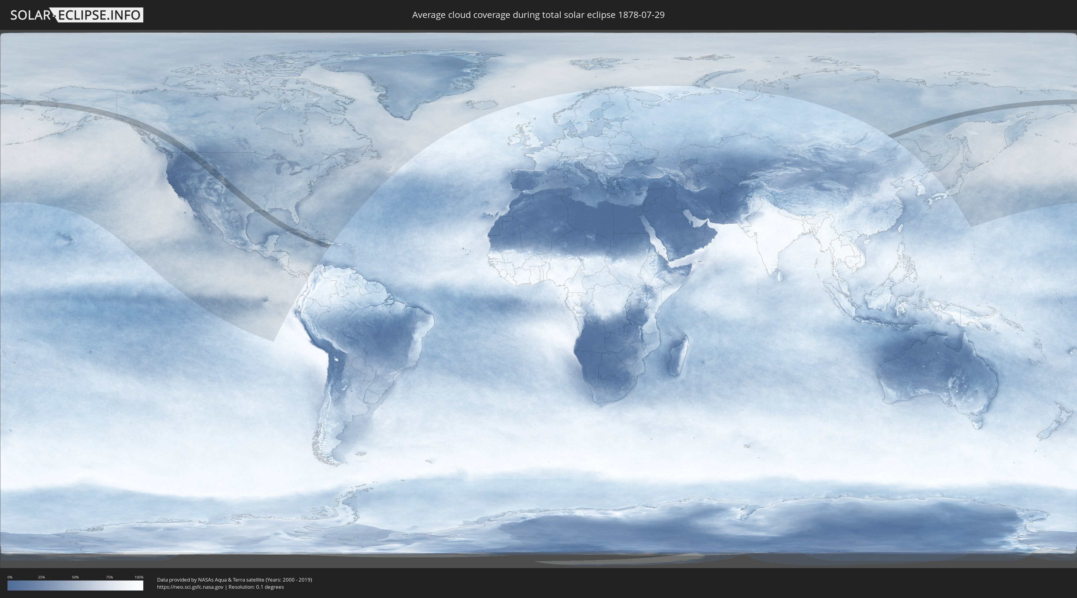
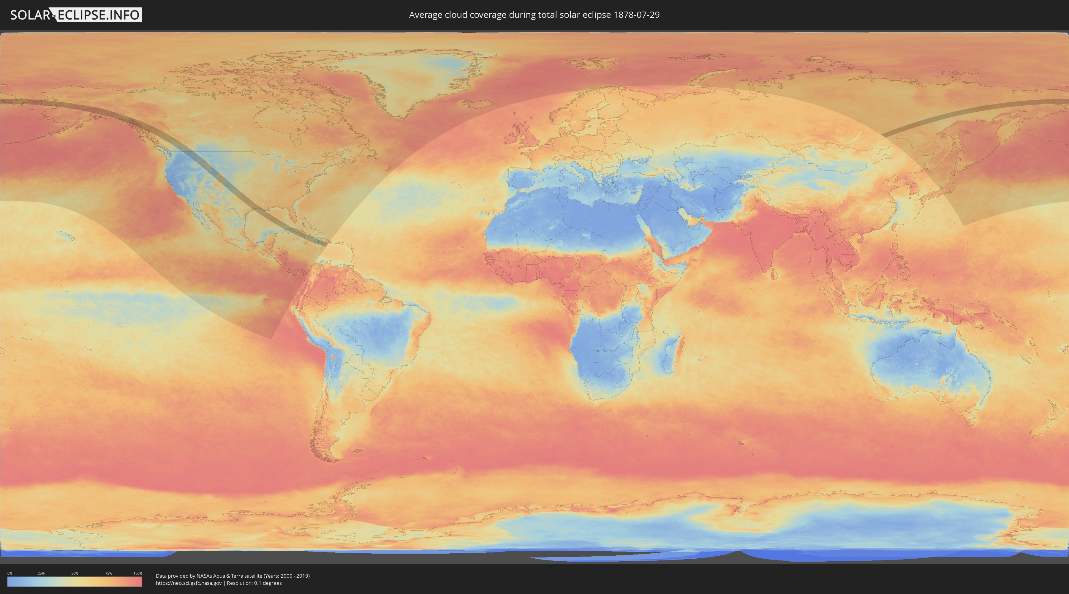
How will be the weather during the total solar eclipse on 07/29/1878?
Where is the best place to see the total solar eclipse of 07/29/1878?
The following maps show the average cloud coverage for the day of the total solar eclipse.
With the help of these maps, it is possible to find the place along the eclipse path, which has the best
chance of a cloudless sky.
Nevertheless, you should consider local circumstances and inform about the weather of your chosen
observation site.
The data is provided by NASAs satellites
AQUA and TERRA.
The cloud maps are averaged over a period of 19 years (2000 - 2019).
Detailed country maps
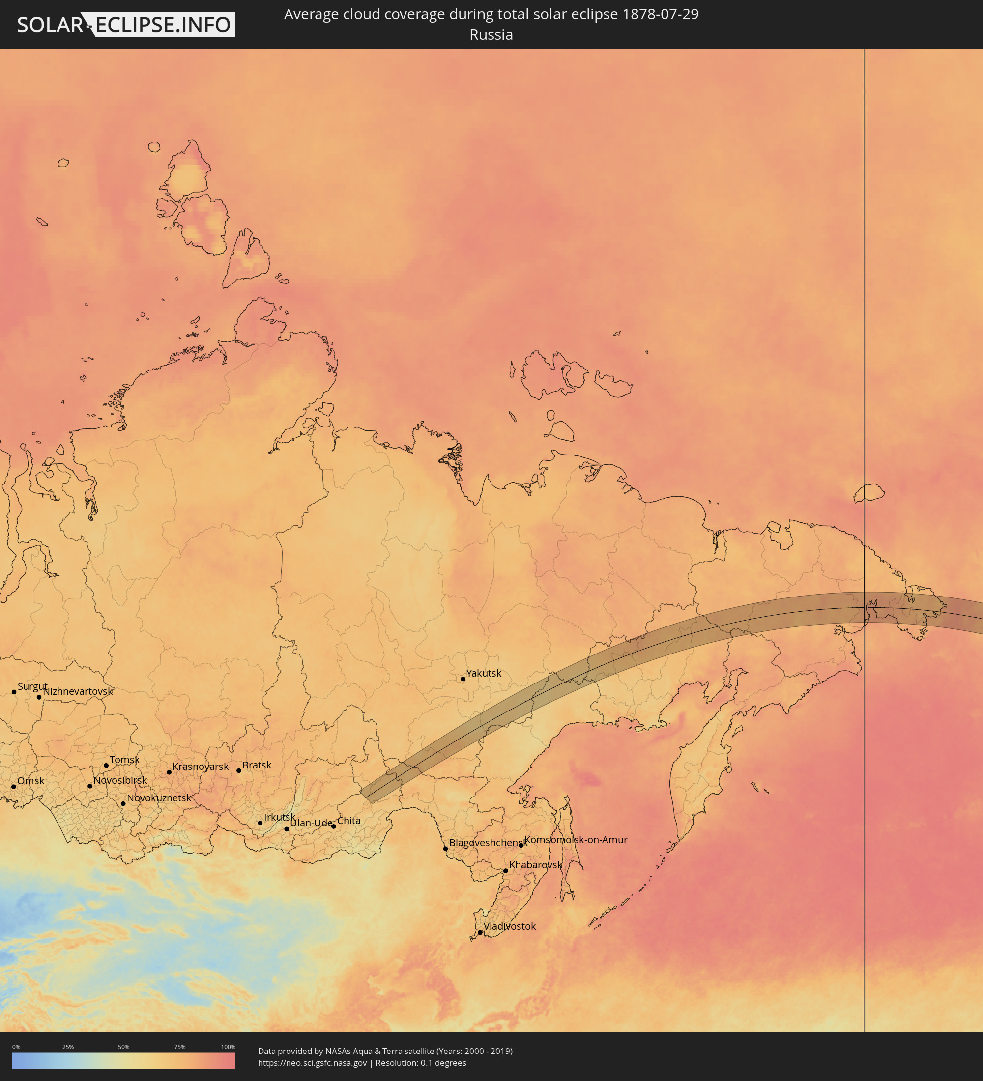 Russia
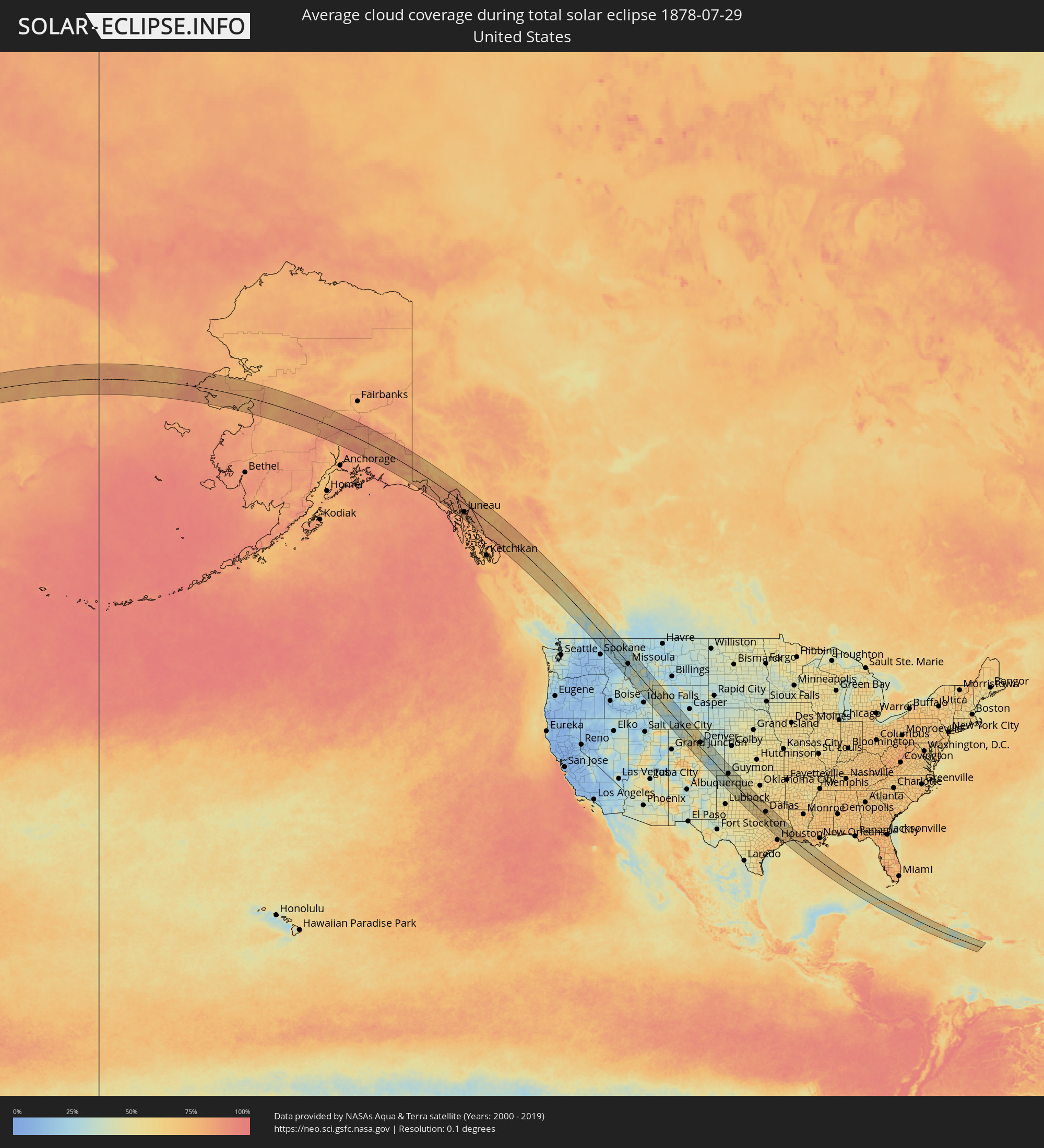 United States
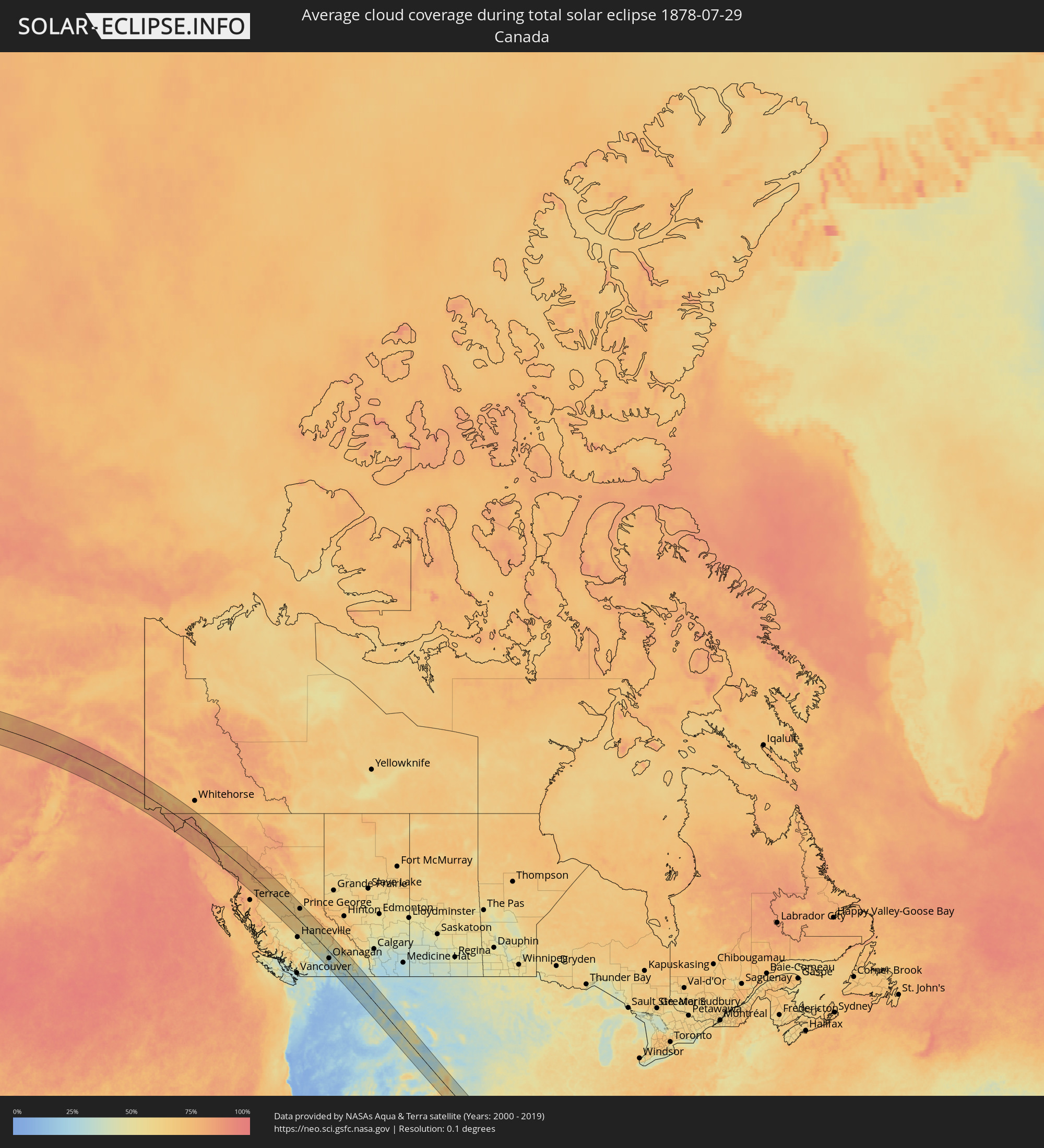 Canada
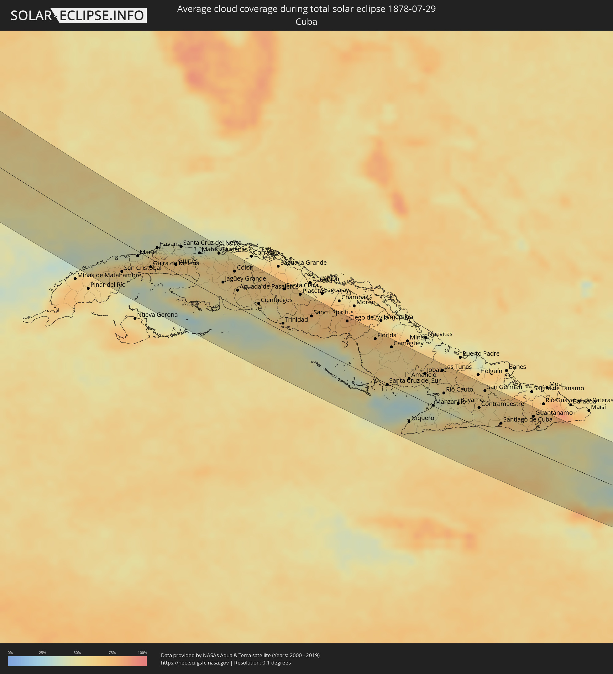 Cuba
Cuba
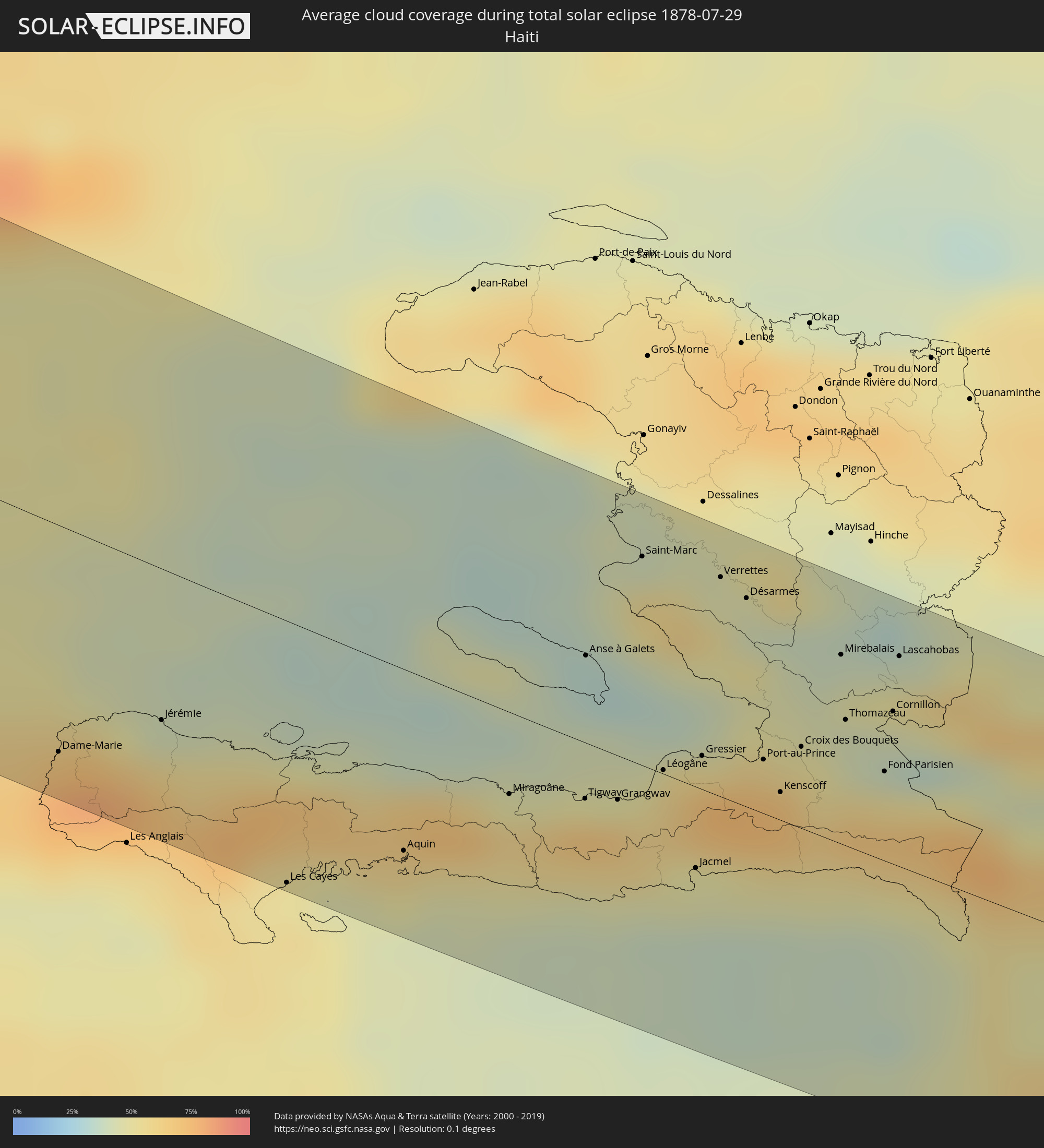 Haiti
Haiti
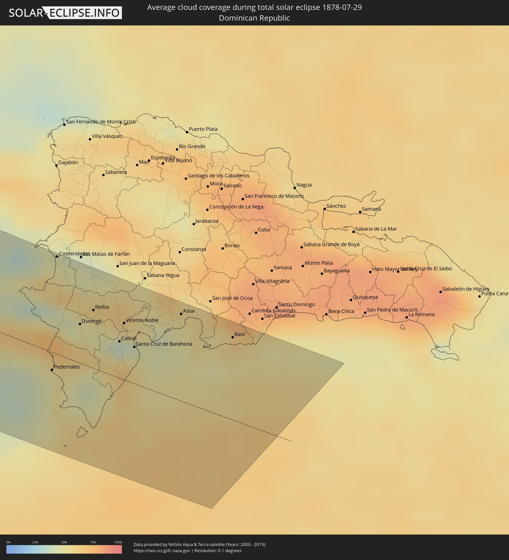 Dominican Republic
Cities inside the path of the eclipse
The following table shows all locations with a population of more than 5,000 inside the eclipse path. Cities which have more than 100,000 inhabitants are marked bold. A click at the locations opens a detailed map.
| City | Type | Eclipse duration | Local time of max. eclipse | Distance to central line | Ø Cloud coverage |
|
Smithers, British Columbia
|
total | - | 13:42:22 UTC-08:00 | 63 km | 70% |
|
Prince George, British Columbia
|
total | - | 13:48:22 UTC-08:00 | 67 km | 62% |
|
Quesnel, British Columbia
|
total | - | 13:50:06 UTC-08:00 | 8 km | 53% |
|
Williams Lake, British Columbia
|
total | - | 13:51:49 UTC-08:00 | 47 km | 51% |
|
Kamloops, British Columbia
|
total | - | 13:56:11 UTC-08:00 | 67 km | 35% |
|
West Kelowna, British Columbia
|
total | - | 13:58:20 UTC-08:00 | 88 km | 27% |
|
Kelowna, British Columbia
|
total | - | 13:58:24 UTC-08:00 | 82 km | 24% |
|
Okanagan, British Columbia
|
total | - | 13:57:43 UTC-08:00 | 38 km | 32% |
|
Salmon Arm, British Columbia
|
total | - | 13:57:11 UTC-08:00 | 23 km | 36% |
|
Vernon, British Columbia
|
total | - | 13:57:58 UTC-08:00 | 44 km | 27% |
|
Revelstoke, British Columbia
|
total | - | 13:57:48 UTC-08:00 | 70 km | 46% |
|
Trail, British Columbia
|
total | - | 14:01:37 UTC-08:00 | 52 km | 23% |
|
Castlegar, British Columbia
|
total | - | 14:01:17 UTC-08:00 | 32 km | 25% |
|
Nelson, British Columbia
|
total | - | 14:01:19 UTC-08:00 | 17 km | 33% |
|
Kimberley, British Columbia
|
total | - | 14:28:26 UTC-07:33 | 91 km | 37% |
|
Cranbrook, British Columbia
|
total | - | 14:28:56 UTC-07:33 | 91 km | 30% |
|
Missoula, Montana
|
total | - | 15:09:17 UTC-07:00 | 5 km | 24% |
|
Boulder, Colorado
|
total | - | 15:29:37 UTC-07:00 | 37 km | 52% |
|
Longmont, Colorado
|
total | - | 15:29:26 UTC-07:00 | 59 km | 44% |
|
Broomfield, Colorado
|
total | - | 15:29:55 UTC-07:00 | 41 km | 43% |
|
Fort Collins, Colorado
|
total | - | 15:28:39 UTC-07:00 | 91 km | 46% |
|
Loveland, Colorado
|
total | - | 15:29:01 UTC-07:00 | 83 km | 47% |
|
Denver, Colorado
|
total | - | 15:30:20 UTC-07:00 | 44 km | 44% |
|
Centennial, Colorado
|
total | - | 15:30:43 UTC-07:00 | 34 km | 40% |
|
Castle Rock, Colorado
|
total | - | 15:31:08 UTC-07:00 | 15 km | 41% |
|
Colorado Springs, Colorado
|
total | - | 15:32:11 UTC-07:00 | 28 km | 56% |
|
Pueblo, Colorado
|
total | - | 15:33:26 UTC-07:00 | 56 km | 37% |
|
Wichita Falls, Texas
|
total | - | 16:45:04 UTC-06:00 | 18 km | 56% |
|
Lawton, Oklahoma
|
total | - | 16:43:51 UTC-06:00 | 75 km | 59% |
|
Fort Worth, Texas
|
total | - | 16:47:44 UTC-06:00 | 29 km | 65% |
|
Keller, Texas
|
total | - | 16:47:23 UTC-06:00 | 23 km | 65% |
|
Waco, Texas
|
total | - | 16:49:53 UTC-06:00 | 90 km | 61% |
|
Mansfield, Texas
|
total | - | 16:48:05 UTC-06:00 | 14 km | 65% |
|
Denton, Texas
|
total | - | 16:46:56 UTC-06:00 | 46 km | 61% |
|
Arlington, Texas
|
total | - | 16:47:48 UTC-06:00 | 24 km | 64% |
|
Flower Mound, Texas
|
total | - | 16:47:18 UTC-06:00 | 39 km | 63% |
|
Carrollton, Texas
|
total | - | 16:47:30 UTC-06:00 | 47 km | 67% |
|
DeSoto, Texas
|
total | - | 16:48:10 UTC-06:00 | 14 km | 68% |
|
Frisco, Texas
|
total | - | 16:47:10 UTC-06:00 | 67 km | 65% |
|
Dallas, Texas
|
total | - | 16:47:50 UTC-06:00 | 32 km | 68% |
|
Plano, Texas
|
total | - | 16:47:28 UTC-06:00 | 60 km | 66% |
|
McKinney, Texas
|
total | - | 16:47:11 UTC-06:00 | 81 km | 62% |
|
Mesquite, Texas
|
total | - | 16:47:57 UTC-06:00 | 45 km | 65% |
|
Rowlett, Texas
|
total | - | 16:47:43 UTC-06:00 | 57 km | 62% |
|
Conroe, Texas
|
total | - | 16:52:41 UTC-06:00 | 87 km | 66% |
|
Tyler, Texas
|
total | - | 16:49:11 UTC-06:00 | 94 km | 66% |
|
Atascocita, Texas
|
total | - | 16:53:19 UTC-06:00 | 94 km | 69% |
|
Beaumont, Texas
|
total | - | 16:53:31 UTC-06:00 | 19 km | 73% |
|
Port Arthur, Texas
|
total | - | 16:53:55 UTC-06:00 | 39 km | 66% |
|
Lake Charles, Louisiana
|
total | - | 16:53:34 UTC-06:00 | 48 km | 74% |
|
San Cristobal, Artemisa
|
total | - | 17:36:47 UTC-05:29 | 55 km | 62% |
|
Artemisa, Artemisa
|
total | - | 17:36:37 UTC-05:29 | 25 km | 62% |
|
Bauta, Artemisa
|
total | - | 17:36:23 UTC-05:29 | 2 km | 64% |
|
Güira de Melena, Artemisa
|
total | - | 17:36:38 UTC-05:29 | 14 km | 64% |
|
Havana, La Habana
|
total | - | 17:36:09 UTC-05:29 | 25 km | 67% |
|
Arroyo Naranjo, La Habana
|
total | - | 17:36:19 UTC-05:29 | 17 km | 67% |
|
San José de las Lajas, Mayabeque
|
total | - | 17:36:23 UTC-05:29 | 35 km | 68% |
|
Güines, Mayabeque
|
total | - | 17:36:33 UTC-05:29 | 18 km | 62% |
|
Matanzas, Matanzas
|
total | - | 17:36:14 UTC-05:29 | 59 km | 62% |
|
Cárdenas, Matanzas
|
total | - | 17:36:12 UTC-05:29 | 75 km | 62% |
|
Jovellanos, Matanzas
|
total | - | 17:36:31 UTC-05:29 | 53 km | 64% |
|
Jagüey Grande, Matanzas
|
total | - | 17:36:54 UTC-05:29 | 40 km | 58% |
|
Colón, Matanzas
|
total | - | 17:36:37 UTC-05:29 | 63 km | 65% |
|
Cienfuegos, Cienfuegos
|
total | - | 17:37:20 UTC-05:29 | 27 km | 45% |
|
Santo Domingo, Villa Clara
|
total | - | 17:36:43 UTC-05:29 | 79 km | 68% |
|
Trinidad, Sancti Spíritus
|
total | - | 17:37:45 UTC-05:29 | 15 km | 59% |
|
Santa Clara, Villa Clara
|
total | - | 17:36:56 UTC-05:29 | 78 km | 63% |
|
Placetas, Villa Clara
|
total | - | 17:37:01 UTC-05:29 | 80 km | 67% |
|
Cabaiguán, Sancti Spíritus
|
total | - | 17:37:19 UTC-05:29 | 69 km | 73% |
|
Sancti Spíritus, Sancti Spíritus
|
total | - | 17:37:30 UTC-05:29 | 56 km | 61% |
|
Ciego de Ávila, Ciego de Ávila
|
total | - | 17:37:31 UTC-05:29 | 76 km | 73% |
|
Florida, Camagüey
|
total | - | 17:37:51 UTC-05:29 | 69 km | 68% |
|
Camagüey, Camagüey
|
total | - | 17:37:59 UTC-05:29 | 73 km | 62% |
|
Jobabo, Las Tunas
|
total | - | 17:38:29 UTC-05:29 | 51 km | 56% |
|
Manzanillo, Granma
|
total | - | 17:39:10 UTC-05:29 | 1 km | 41% |
|
Las Tunas, Las Tunas
|
total | - | 17:38:21 UTC-05:29 | 71 km | 61% |
|
Bartolomé Masó, Granma
|
total | - | 17:39:21 UTC-05:29 | 9 km | 52% |
|
Bayamo, Granma
|
total | - | 17:39:01 UTC-05:29 | 38 km | 50% |
|
Contramaestre, Santiago de Cuba
|
total | - | 17:39:02 UTC-05:29 | 37 km | 52% |
|
San Germán, Holguín
|
total | - | 17:38:38 UTC-05:29 | 71 km | 60% |
|
Palma Soriano, Santiago de Cuba
|
total | - | 17:39:05 UTC-05:29 | 40 km | 59% |
|
San Luis, Santiago de Cuba
|
total | - | 17:39:05 UTC-05:29 | 41 km | 61% |
|
Santiago de Cuba, Santiago de Cuba
|
total | - | 17:39:17 UTC-05:29 | 26 km | 57% |
|
Guantánamo, Guantánamo
|
total | - | 17:38:59 UTC-05:29 | 64 km | 66% |
|
Dame-Marie, GrandʼAnse
|
total | - | 18:21:17 UTC-04:49 | 65 km | 70% |
|
Jérémie, GrandʼAnse
|
total | - | 18:21:06 UTC-04:49 | 44 km | 43% |
|
Les Cayes, Sud
|
total | - | 18:21:32 UTC-04:49 | 76 km | 51% |
|
Aquin, Sud
|
total | - | 18:21:19 UTC-04:49 | 53 km | 58% |
|
Miragoâne, Nippes
|
total | - | 18:21:02 UTC-04:49 | 24 km | 60% |
|
Tigwav, Ouest
|
total | - | 18:20:59 UTC-04:49 | 16 km | 66% |
|
Anse à Galets, Ouest
|
total | - | 18:20:31 UTC-04:49 | 25 km | 35% |
|
Grangwav, Ouest
|
total | - | 18:20:57 UTC-04:49 | 13 km | 66% |
|
Saint-Marc, Artibonite
|
total | - | 18:20:08 UTC-04:49 | 61 km | 56% |
|
Léogâne, Ouest
|
total | - | 18:20:49 UTC-04:49 | 1 km | 63% |
|
Jacmel, Sud-Est
|
total | - | 18:21:06 UTC-04:49 | 24 km | 45% |
|
Gressier, Ouest
|
total | - | 18:20:44 UTC-04:49 | 10 km | 55% |
|
Verrettes, Artibonite
|
total | - | 18:20:08 UTC-04:49 | 64 km | 46% |
|
Carrefour, Ouest
|
total | - | 18:20:42 UTC-04:49 | 13 km | 73% |
|
Désarmes, Artibonite
|
total | - | 18:20:10 UTC-04:49 | 61 km | 43% |
|
Port-au-Prince, Ouest
|
total | - | 18:20:41 UTC-04:49 | 16 km | 69% |
|
Delmas 73, Ouest
|
total | - | 18:20:40 UTC-04:49 | 17 km | 69% |
|
Pétionville, Ouest
|
total | - | 18:20:42 UTC-04:49 | 15 km | 69% |
|
Kenscoff, Ouest
|
total | - | 18:20:47 UTC-04:49 | 8 km | 70% |
|
Croix des Bouquets, Ouest
|
total | - | 18:20:37 UTC-04:49 | 24 km | 50% |
|
Mirebalais, Centre
|
total | - | 18:20:16 UTC-04:49 | 55 km | 47% |
|
Thomazeau, Ouest
|
total | - | 18:20:29 UTC-04:49 | 44 km | 42% |
|
Fond Parisien, Ouest
|
total | - | 18:20:37 UTC-04:49 | 27 km | 54% |
|
Cornillon, Ouest
|
total | - | 18:20:24 UTC-04:49 | 46 km | 43% |
|
Lascahobas, Centre
|
total | - | 18:20:13 UTC-04:49 | 63 km | 56% |
|
Jimaní, Independencia
|
total | - | 18:29:35 UTC-04:40 | 30 km | 52% |
|
Pedernales, Pedernales
|
total | - | 18:30:04 UTC-04:40 | 26 km | 53% |
|
La Descubierta, Independencia
|
total | - | 18:29:27 UTC-04:40 | 45 km | 44% |
|
Comendador, Elías Piña
|
total | - | 18:29:05 UTC-04:40 | 75 km | 50% |
|
Duvergé, Independencia
|
total | - | 18:29:36 UTC-04:40 | 33 km | 48% |
|
Cercado Abajo, San Juan
|
total | - | 18:29:12 UTC-04:40 | 72 km | 57% |
|
Villa Jaragua, Baoruco
|
total | - | 18:29:28 UTC-04:40 | 46 km | 49% |
|
Neiba, Baoruco
|
total | - | 18:29:27 UTC-04:40 | 45 km | 53% |
|
Galván, Baoruco
|
total | - | 18:29:24 UTC-04:40 | 50 km | 57% |
|
Vallejuelo, San Juan
|
total | - | 18:29:14 UTC-04:40 | 66 km | 53% |
|
Enriquillo, Barahona
|
total | - | 18:30:03 UTC-04:40 | 25 km | 60% |
|
Cabral, Barahona
|
total | - | 18:29:39 UTC-04:40 | 35 km | 37% |
|
Tamayo, Baoruco
|
total | - | 18:29:29 UTC-04:40 | 47 km | 49% |
|
Vicente Noble, Barahona
|
total | - | 18:29:29 UTC-04:40 | 48 km | 49% |
|
Paraíso, Barahona
|
total | - | 18:29:55 UTC-04:40 | 20 km | 62% |
|
Santa Cruz de Barahona, Barahona
|
total | - | 18:29:39 UTC-04:40 | 36 km | 51% |
|
Yayas de Viajama, Azua
|
total | - | 18:29:08 UTC-04:40 | 79 km | 57% |
|
Azua, Azua
|
total | - | 18:29:15 UTC-04:40 | 68 km | 53% |
|
Estebanía, Azua
|
total | - | 18:29:13 UTC-04:40 | 73 km | 59% |
|
Baní, Peravia
|
total | - | 18:29:18 UTC-04:40 | 64 km | 61% |
|
Paya, Peravia
|
total | - | 18:29:19 UTC-04:40 | 64 km | 61% |
|
Nizao, Peravia
|
total | - | 18:29:18 UTC-04:40 | 66 km | 51% |
|
Yaguate, San Cristóbal
|
total | - | 18:29:11 UTC-04:40 | 76 km | 59% |
|
Neryungri, Sakha
|
total | - | 05:03:57 UTC+08:38 | 19 km | 71% |
|
Chul’man, Sakha
|
total | - | 05:04:05 UTC+08:38 | 17 km | 72% |
|
Susuman, Magadan
|
total | - | 06:46:27 UTC+10:14 | 29 km | 71% |