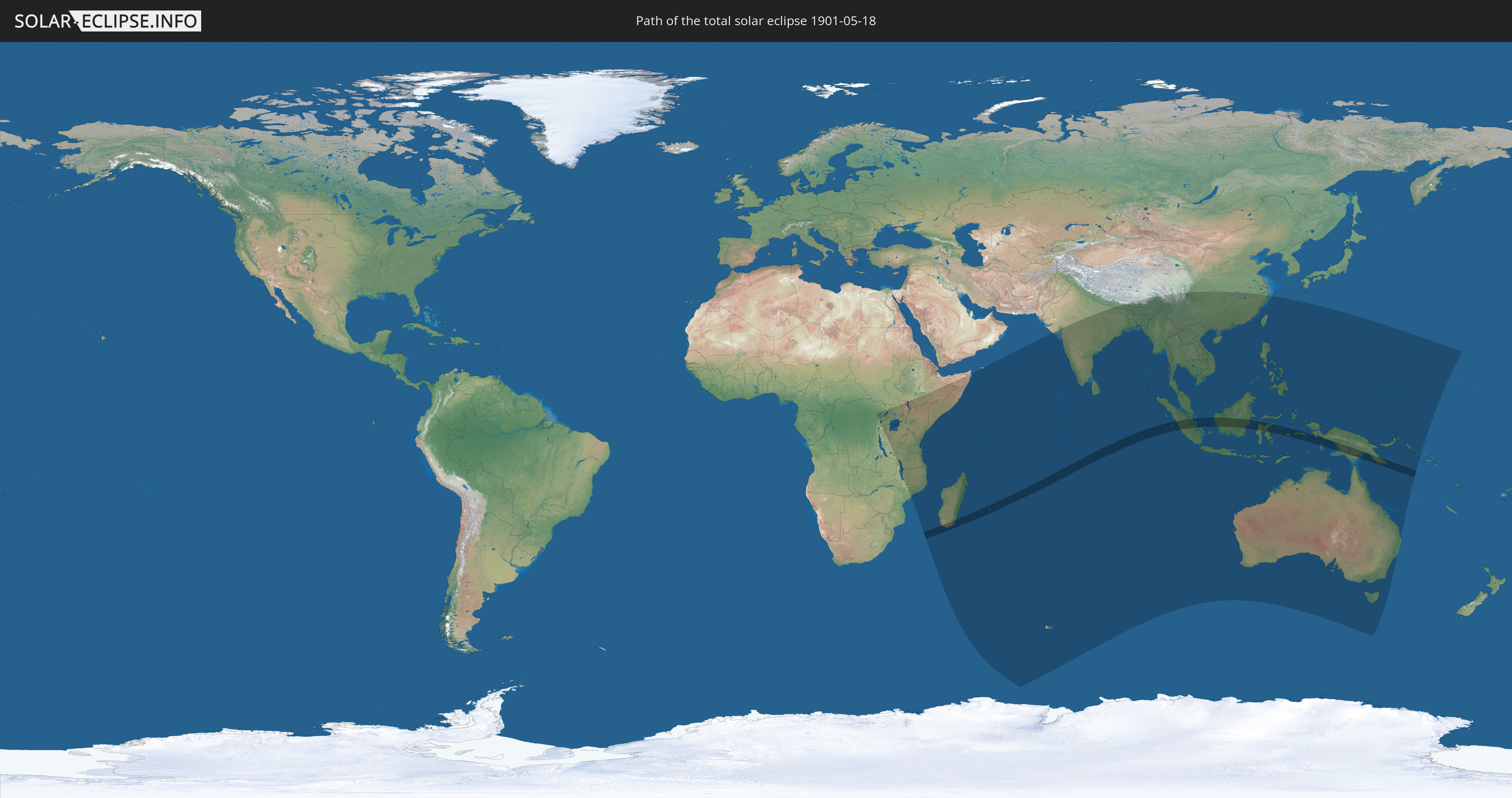
Total solar eclipse of 05/18/1901
| Day of week: | Saturday |
| Maximum duration of eclipse: | 06m29s |
| Maximum width of eclipse path: | 238 km |
| Saros cycle: | 136 |
| Coverage: | 100% |
| Magnitude: | 1.068 |
| Gamma: | -0.3626 |
Wo kann man die Sonnenfinsternis vom 05/18/1901 sehen?
Die Sonnenfinsternis am 05/18/1901 kann man in 52 Ländern als partielle Sonnenfinsternis beobachten.
Der Finsternispfad verläuft durch 5 Länder. Nur in diesen Ländern ist sie als total Sonnenfinsternis zu sehen.
In den folgenden Ländern ist die Sonnenfinsternis total zu sehen
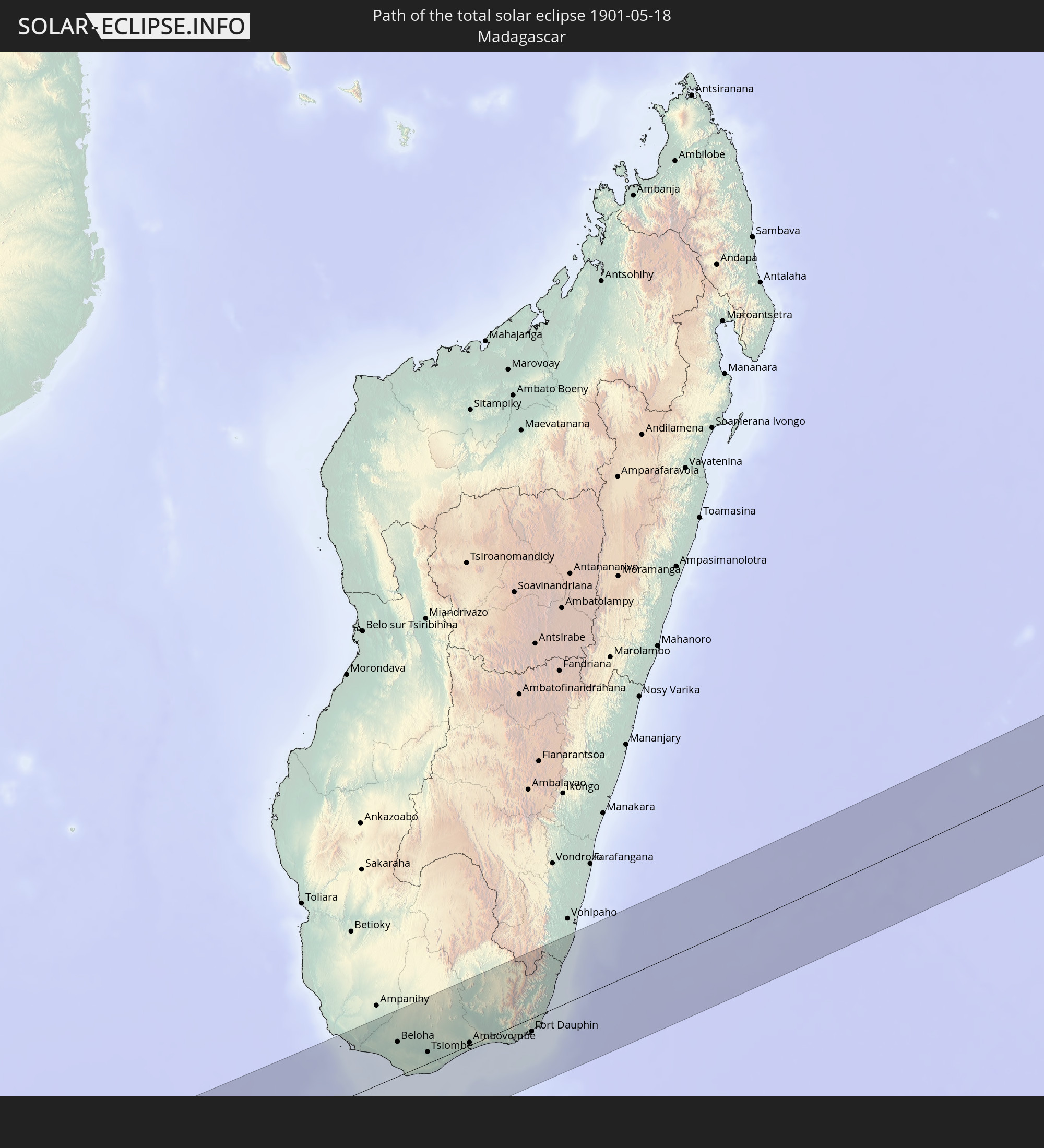 Madagascar
 Réunion
 Mauritius
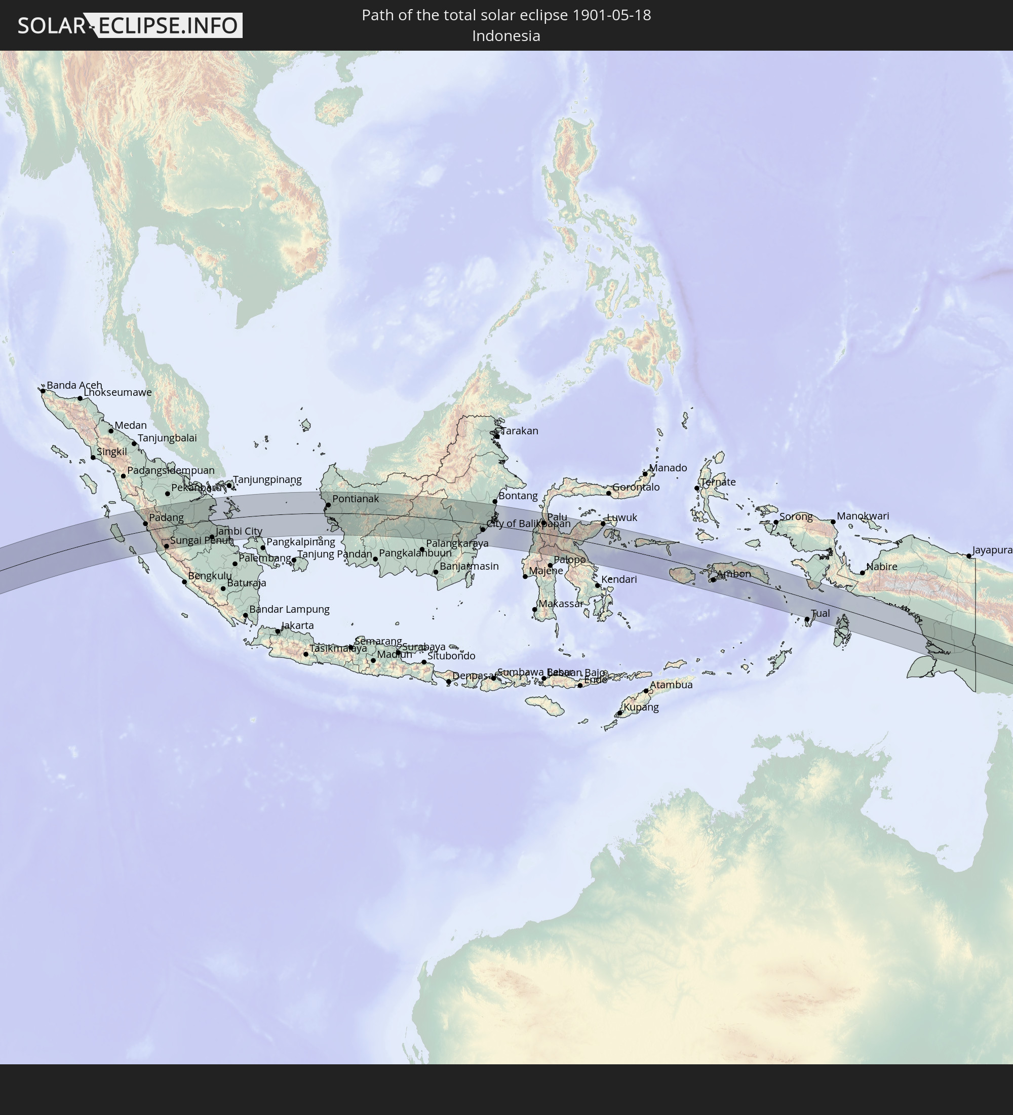 Indonesia
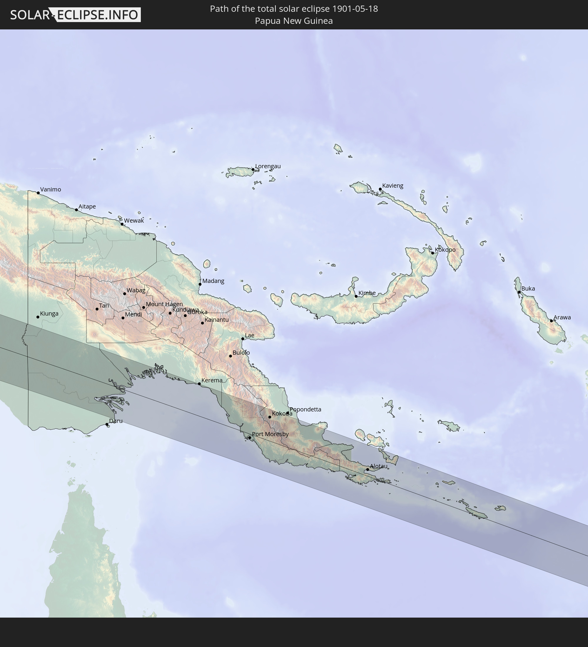 Papua New Guinea
In den folgenden Ländern ist die Sonnenfinsternis partiell zu sehen
 Democratic Republic of the Congo
 Rwanda
 Burundi
 Tanzania
 Uganda
 Mozambique
 Malawi
 Ethiopia
 Kenya
Kenya
 French Southern and Antarctic Lands
 Somalia
 Yemen
Yemen
 Madagascar
 Comoros
 Mayotte
 Seychelles
 Réunion
 Mauritius
 India
India
 British Indian Ocean Territory
 Heard Island and McDonald Islands
 Maldives
 China
China
 Sri Lanka
 Nepal
Nepal
 Bangladesh
 Bhutan
 Myanmar
 Indonesia
 Cocos Islands
 Thailand
 Malaysia
 Laos
Laos
 Vietnam
 Cambodia
 Singapore
 Christmas Island
 Australia
 Macau
Macau
 Hong Kong
 Brunei
 Taiwan
 Philippines
 Japan
Japan
 East Timor
 Palau
Palau
 Federated States of Micronesia
 Papua New Guinea
 Guam
Guam
 Northern Mariana Islands
 Solomon Islands
 Marshall Islands
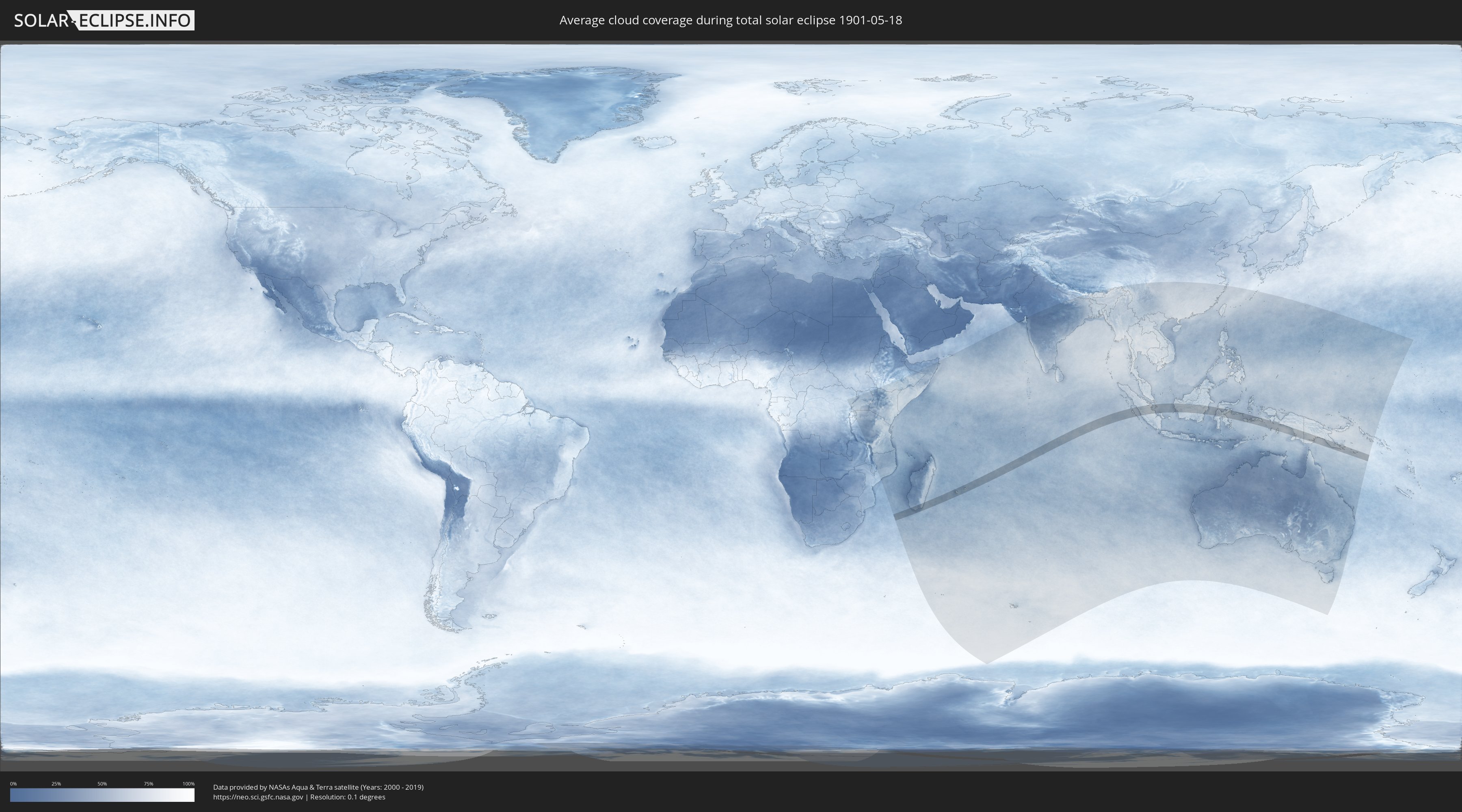
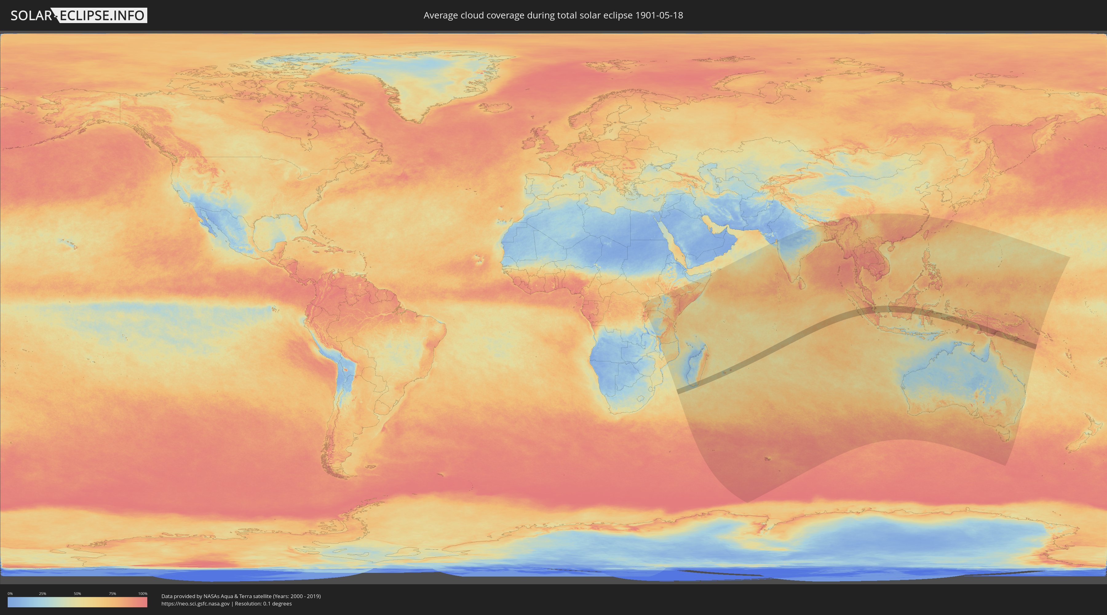
How will be the weather during the total solar eclipse on 05/18/1901?
Where is the best place to see the total solar eclipse of 05/18/1901?
The following maps show the average cloud coverage for the day of the total solar eclipse.
With the help of these maps, it is possible to find the place along the eclipse path, which has the best
chance of a cloudless sky.
Nevertheless, you should consider local circumstances and inform about the weather of your chosen
observation site.
The data is provided by NASAs satellites
AQUA and TERRA.
The cloud maps are averaged over a period of 19 years (2000 - 2019).
Detailed country maps
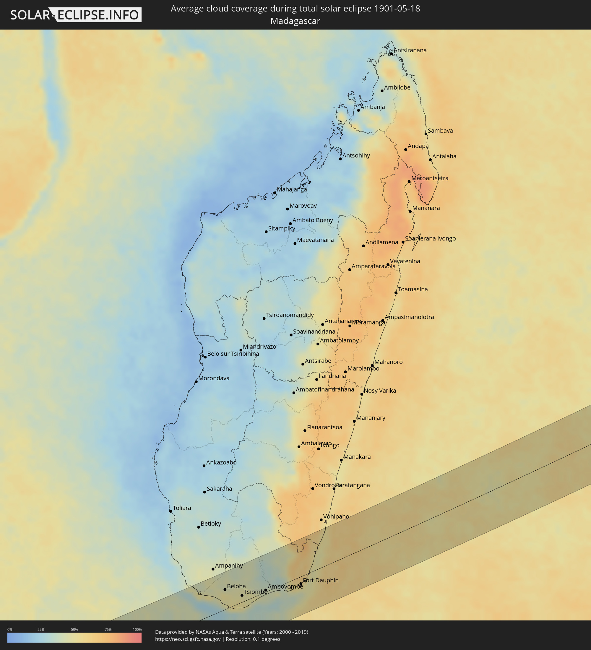 Madagascar
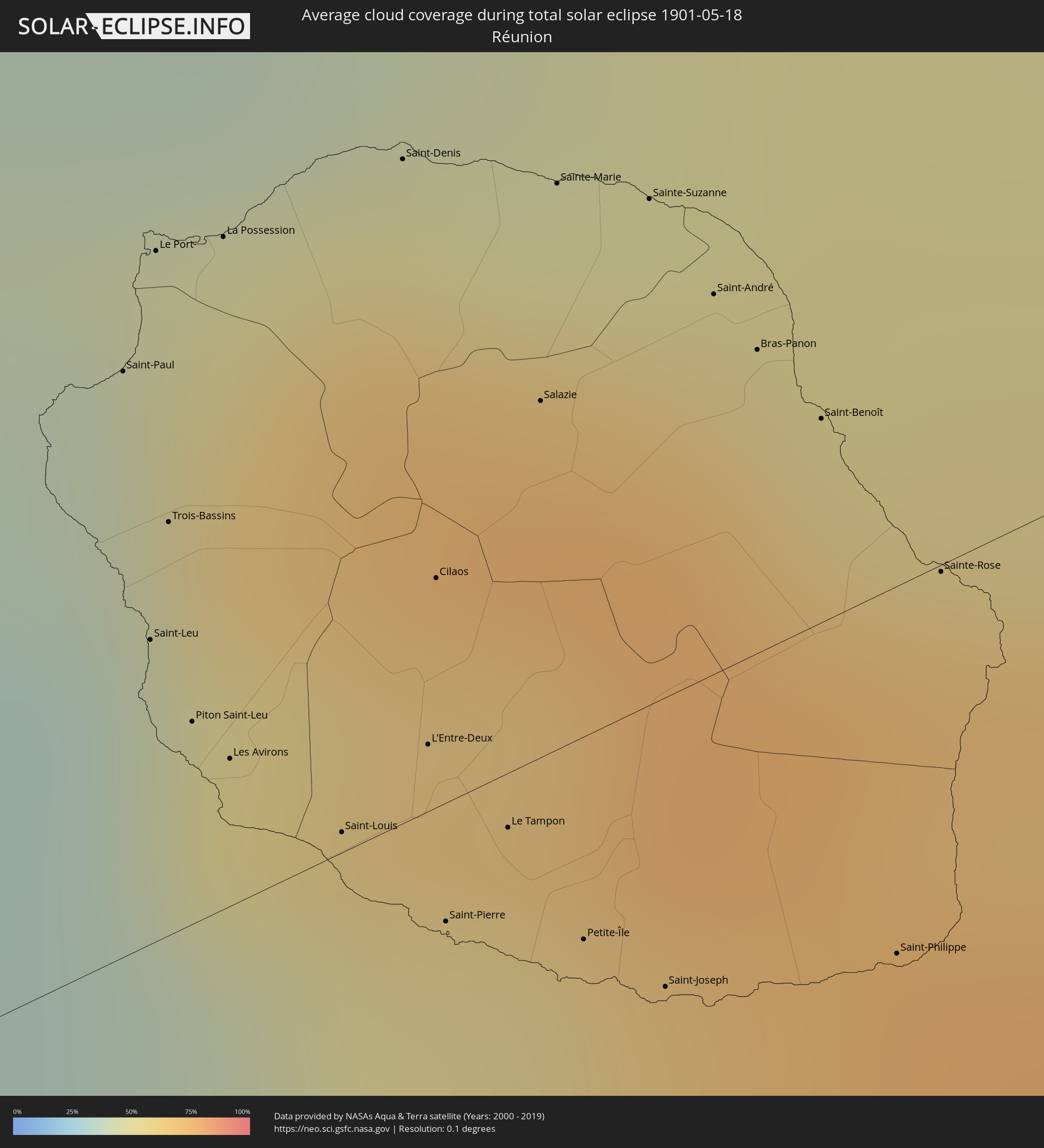 Réunion
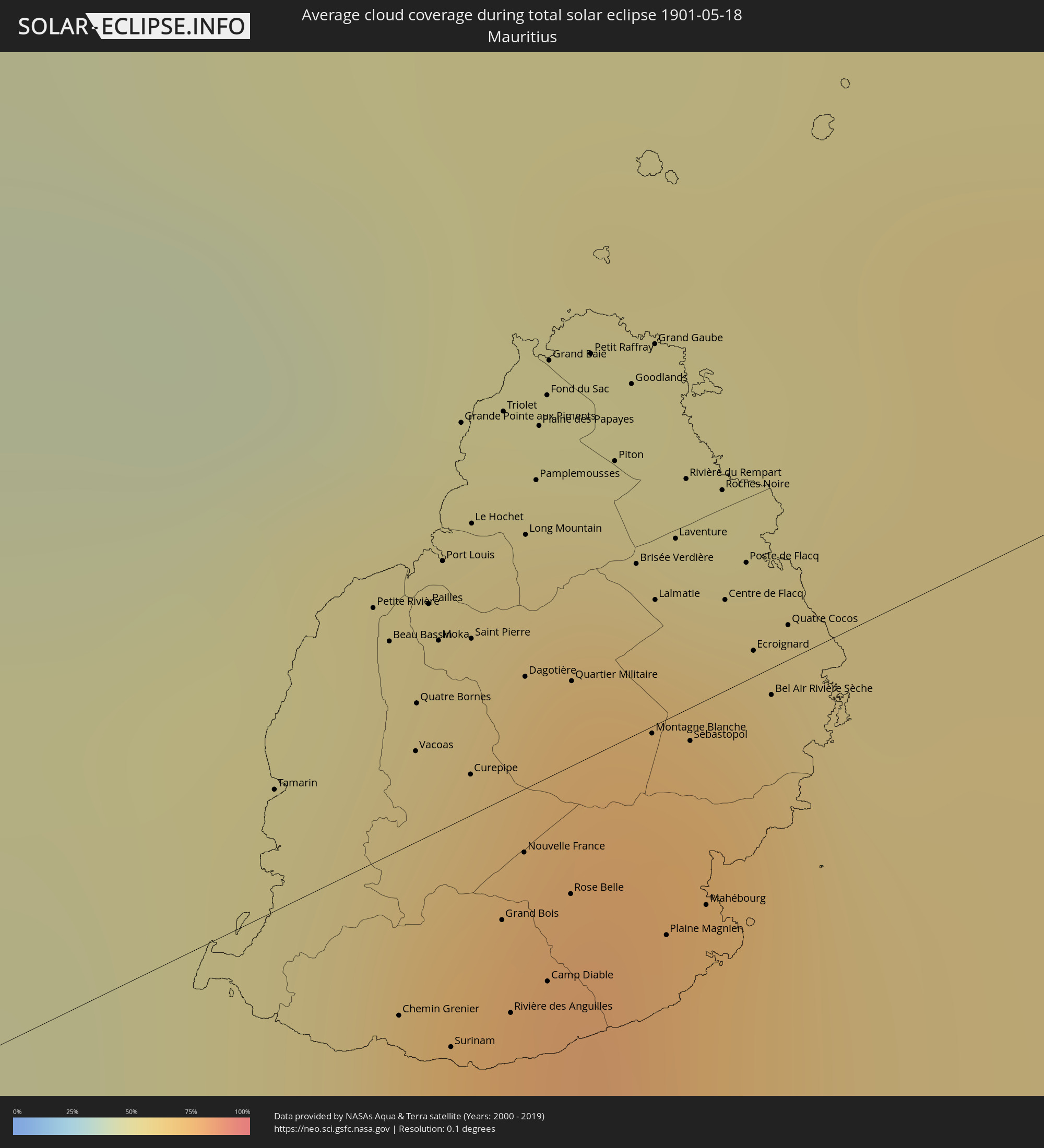 Mauritius
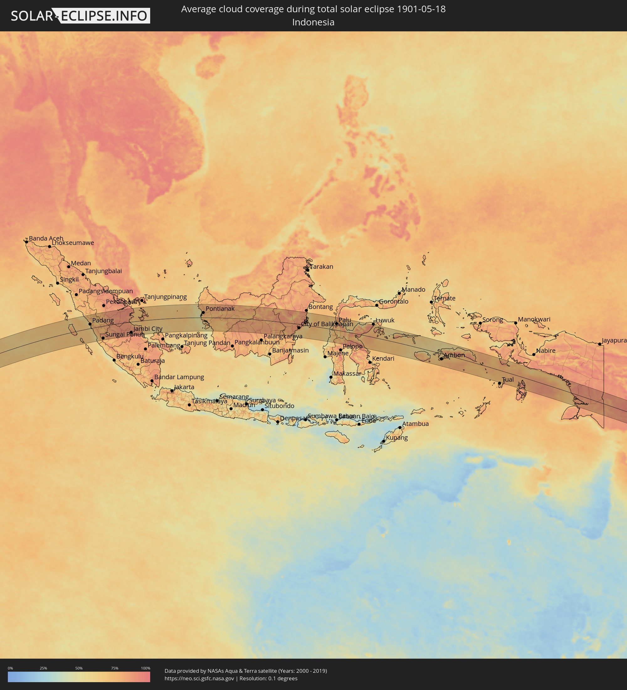 Indonesia
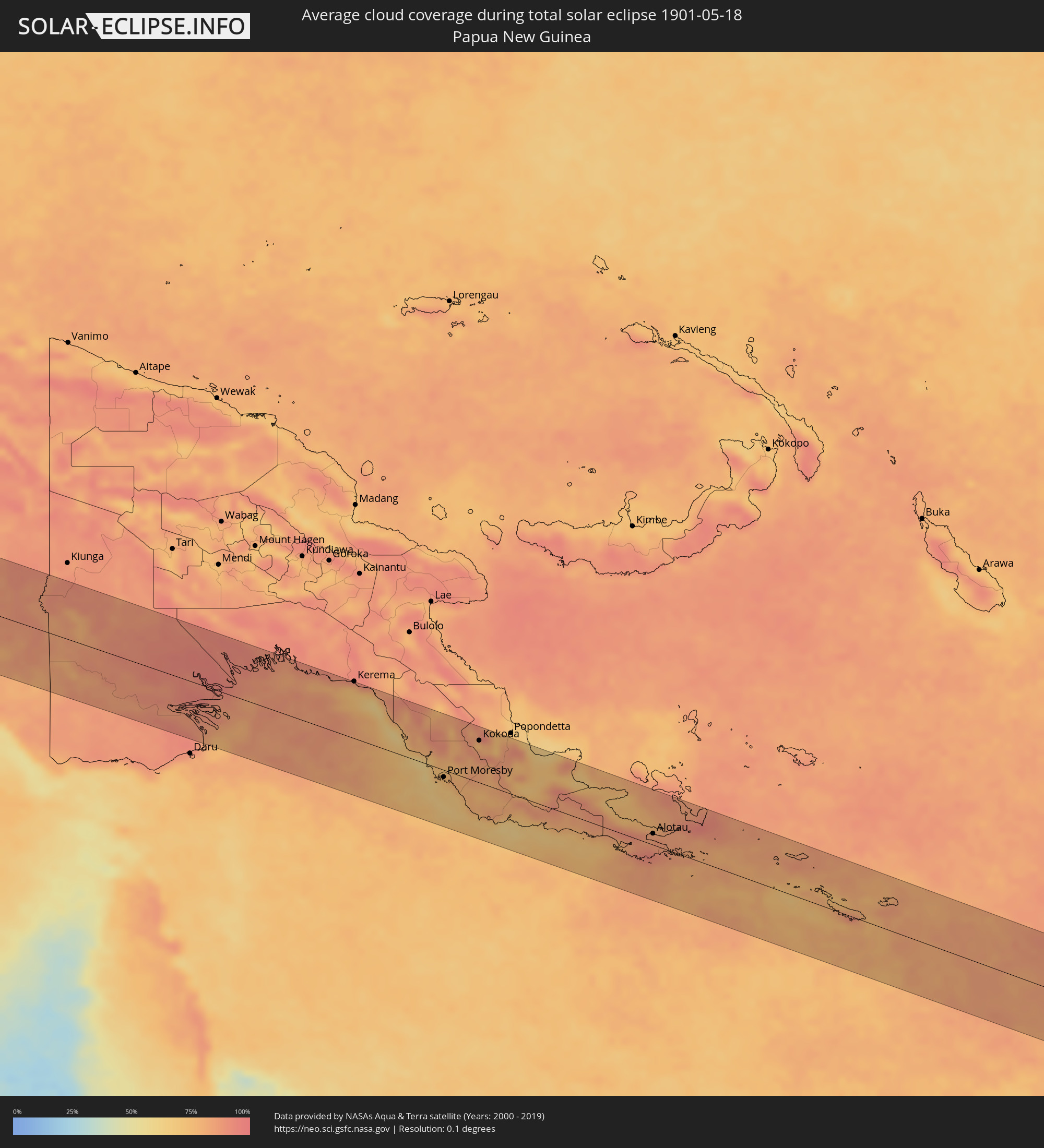 Papua New Guinea
Cities inside the path of the eclipse
The following table shows all locations with a population of more than 5,000 inside the eclipse path. Cities which have more than 100,000 inhabitants are marked bold. A click at the locations opens a detailed map.
| City | Type | Eclipse duration | Local time of max. eclipse | Distance to central line | Ø Cloud coverage |
|
Tranovaho, Androy
|
total | - | 06:25:00 UTC+02:27 | 36 km | 47% |
|
Beloha, Androy
|
total | - | 06:24:59 UTC+02:27 | 46 km | 51% |
|
Kopoky, Androy
|
total | - | 06:25:02 UTC+02:27 | 37 km | 50% |
|
Tsiombe, Androy
|
total | - | 06:25:09 UTC+02:27 | 15 km | 51% |
|
Ambovombe, Androy
|
total | - | 06:25:18 UTC+02:27 | 3 km | 42% |
|
Amboasary, Anosy
|
total | - | 06:25:21 UTC+02:27 | 6 km | 41% |
|
Fort Dauphin, Anosy
|
total | - | 06:25:33 UTC+02:27 | 18 km | 47% |
|
Saint-Paul, Réunion
|
total | - | 07:43:32 UTC+03:41 | 35 km | 60% |
|
Saint-Leu, Réunion
|
total | - | 07:43:33 UTC+03:41 | 18 km | 42% |
|
Le Port, Réunion
|
total | - | 07:43:32 UTC+03:41 | 42 km | 56% |
|
Trois-Bassins, Réunion
|
total | - | 07:43:33 UTC+03:41 | 25 km | 53% |
|
Piton Saint-Leu, Réunion
|
total | - | 07:43:35 UTC+03:41 | 12 km | 42% |
|
La Possession, Réunion
|
total | - | 07:43:34 UTC+03:41 | 40 km | 56% |
|
Les Avirons, Réunion
|
total | - | 07:43:36 UTC+03:41 | 9 km | 42% |
|
Saint-Louis, Réunion
|
total | - | 07:43:39 UTC+03:41 | 1 km | 41% |
|
Saint-Denis, Réunion
|
total | - | 07:43:38 UTC+03:41 | 40 km | 66% |
|
L'Entre-Deux, Réunion
|
total | - | 07:43:41 UTC+03:41 | 4 km | 56% |
|
Cilaos, Réunion
|
total | - | 07:43:40 UTC+03:41 | 14 km | 65% |
|
Saint-Pierre, Réunion
|
total | - | 07:43:42 UTC+03:41 | 7 km | 45% |
|
Le Tampon, Réunion
|
total | - | 07:43:43 UTC+03:41 | 3 km | 45% |
|
Salazie, Réunion
|
total | - | 07:43:43 UTC+03:41 | 21 km | 75% |
|
Sainte-Marie, Réunion
|
total | - | 07:43:42 UTC+03:41 | 34 km | 66% |
|
Petite-Île, Réunion
|
total | - | 07:43:46 UTC+03:41 | 12 km | 48% |
|
Sainte-Suzanne, Réunion
|
total | - | 07:43:45 UTC+03:41 | 30 km | 62% |
|
Saint-Joseph, Réunion
|
total | - | 07:43:48 UTC+03:41 | 17 km | 48% |
|
Saint-André, Réunion
|
total | - | 07:43:47 UTC+03:41 | 23 km | 61% |
|
Bras-Panon, Réunion
|
total | - | 07:43:48 UTC+03:41 | 18 km | 61% |
|
Saint-Benoît, Réunion
|
total | - | 07:43:50 UTC+03:41 | 12 km | 61% |
|
Saint-Philippe, Réunion
|
total | - | 07:43:54 UTC+03:41 | 22 km | 55% |
|
Sainte-Rose, Réunion
|
total | - | 07:43:54 UTC+03:41 | 1 km | 69% |
|
Chemin Grenier, Savanne
|
total | - | 07:53:11 UTC+03:50 | 12 km | 64% |
|
Vacoas, Plaines Wilhems
|
total | - | 07:53:11 UTC+03:50 | 7 km | 73% |
|
Pailles, Moka
|
total | - | 07:53:11 UTC+03:50 | 17 km | 65% |
|
Moka, Moka
|
total | - | 07:53:12 UTC+03:50 | 14 km | 65% |
|
Port Louis, Port Louis
|
total | - | 07:53:11 UTC+03:50 | 19 km | 65% |
|
Surinam, Savanne
|
total | - | 07:53:13 UTC+03:50 | 16 km | 64% |
|
Grande Pointe aux Piments, Pamplemousses
|
total | - | 07:53:12 UTC+03:50 | 28 km | 59% |
|
Terre Rouge, Pamplemousses
|
total | - | 07:53:13 UTC+03:50 | 22 km | 59% |
|
Grand Bois, Savanne
|
total | - | 07:53:14 UTC+03:50 | 9 km | 72% |
|
Rivière des Anguilles, Savanne
|
total | - | 07:53:15 UTC+03:50 | 16 km | 64% |
|
Morcellemont Saint André, Pamplemousses
|
total | - | 07:53:14 UTC+03:50 | 25 km | 69% |
|
Nouvelle France, Grand Port
|
total | - | 07:53:15 UTC+03:50 | 5 km | 72% |
|
Dagotière, Moka
|
total | - | 07:53:15 UTC+03:50 | 8 km | 76% |
|
Long Mountain, Pamplemousses
|
total | - | 07:53:14 UTC+03:50 | 18 km | 69% |
|
Pamplemousses, Pamplemousses
|
total | - | 07:53:15 UTC+03:50 | 22 km | 69% |
|
Plaine des Papayes, Pamplemousses
|
total | - | 07:53:15 UTC+03:50 | 25 km | 69% |
|
Fond du Sac, Pamplemousses
|
total | - | 07:53:15 UTC+03:50 | 27 km | 56% |
|
Grand Baie, Rivière du Rempart
|
total | - | 07:53:15 UTC+03:50 | 30 km | 56% |
|
Rose Belle, Grand Port
|
total | - | 07:53:17 UTC+03:50 | 9 km | 72% |
|
Quartier Militaire, Moka
|
total | - | 07:53:16 UTC+03:50 | 6 km | 76% |
|
Petit Raffray, Rivière du Rempart
|
total | - | 07:53:16 UTC+03:50 | 29 km | 56% |
|
New Grove, Grand Port
|
total | - | 07:53:18 UTC+03:50 | 11 km | 72% |
|
Piton, Rivière du Rempart
|
total | - | 07:53:17 UTC+03:50 | 20 km | 69% |
|
Goodlands, Rivière du Rempart
|
total | - | 07:53:18 UTC+03:50 | 25 km | 56% |
|
Brisée Verdière, Flacq
|
total | - | 07:53:18 UTC+03:50 | 12 km | 76% |
|
Bon Accueil, Flacq
|
total | - | 07:53:19 UTC+03:50 | 11 km | 74% |
|
Montagne Blanche
|
total | - | 07:53:19 UTC+03:50 | 1 km | 72% |
|
Grand Gaube, Rivière du Rempart
|
total | - | 07:53:18 UTC+03:50 | 27 km | 53% |
|
Lalmatie, Flacq
|
total | - | 07:53:19 UTC+03:50 | 9 km | 74% |
|
Plaine Magnien, Grand Port
|
total | - | 07:53:20 UTC+03:50 | 15 km | 65% |
|
Laventure, Flacq
|
total | - | 07:53:20 UTC+03:50 | 13 km | 66% |
|
Rivière du Rempart, Rivière du Rempart
|
total | - | 07:53:20 UTC+03:50 | 17 km | 66% |
|
Sebastopol, Flacq
|
total | - | 07:53:21 UTC+03:50 | 2 km | 72% |
|
Beau Vallon, Grand Port
|
total | - | 07:53:21 UTC+03:50 | 16 km | 65% |
|
Mahébourg, Grand Port
|
total | - | 07:53:22 UTC+03:50 | 15 km | 65% |
|
Roches Noire, Rivière du Rempart
|
total | - | 07:53:21 UTC+03:50 | 14 km | 66% |
|
Centre de Flacq, Flacq
|
total | - | 07:53:22 UTC+03:50 | 6 km | 74% |
|
Poste de Flacq, Flacq
|
total | - | 07:53:22 UTC+03:50 | 8 km | 74% |
|
Ecroignard, Flacq
|
total | - | 07:53:23 UTC+03:50 | 2 km | 74% |
|
Quatre Cocos, Flacq
|
total | - | 07:53:24 UTC+03:50 | 2 km | 61% |
|
Pariaman, West Sumatra
|
total | - | 12:47:05 UTC+07:07 | 76 km | 60% |
|
Padang, West Sumatra
|
total | - | 12:47:37 UTC+07:07 | 35 km | 73% |
|
Bukittinggi, West Sumatra
|
total | - | 12:48:05 UTC+07:07 | 105 km | 79% |
|
Payakumbuh, West Sumatra
|
total | - | 12:48:58 UTC+07:07 | 110 km | 72% |
|
Solok, West Sumatra
|
total | - | 12:48:40 UTC+07:07 | 45 km | 73% |
|
Sijunjung, West Sumatra
|
total | - | 12:49:45 UTC+07:07 | 50 km | 65% |
|
Sungai Penuh, Jambi
|
total | - | 12:50:12 UTC+07:07 | 107 km | 74% |
|
Bejubang Dua, Jambi
|
total | - | 12:56:30 UTC+07:07 | 111 km | 87% |
|
Kuala Tungkal, Jambi
|
total | - | 12:57:31 UTC+07:07 | 5 km | 82% |
|
Mendaha, Jambi
|
total | - | 12:57:49 UTC+07:07 | 29 km | 87% |
|
Jambi City, Jambi
|
total | - | 12:57:34 UTC+07:07 | 94 km | 89% |
|
Simpang, Jambi
|
total | - | 12:59:16 UTC+07:07 | 63 km | 84% |
|
Pontianak, West Kalimantan
|
total | - | 13:15:44 UTC+07:07 | 42 km | 81% |
|
Balikpapan, East Kalimantan
|
total | - | 14:25:50 UTC+07:57 | 37 km | 61% |
|
City of Balikpapan, East Kalimantan
|
total | - | 14:25:59 UTC+07:57 | 33 km | 78% |
|
Loa Janan, East Kalimantan
|
total | - | 14:26:38 UTC+07:57 | 43 km | 90% |
|
Samarinda, East Kalimantan
|
total | - | 14:26:46 UTC+07:57 | 53 km | 86% |
|
Palu, Central Sulawesi
|
total | - | 14:32:55 UTC+07:57 | 55 km | 78% |
|
Poso, Central Sulawesi
|
total | - | 14:34:43 UTC+07:57 | 19 km | 63% |
|
Ambon, Maluku
|
total | - | 16:13:15 UTC+09:22 | 45 km | 75% |
|
Amahai, Maluku
|
total | - | 16:14:27 UTC+09:22 | 14 km | 66% |
|
Port Moresby, National Capital
|
total | - | 17:08:14 UTC+10:00 | 12 km | 74% |
|
Kokoda, Northern Province
|
total | - | 17:08:40 UTC+10:00 | 68 km | 85% |
|
Alotau, Milne Bay
|
total | - | 17:09:24 UTC+10:00 | 18 km | 87% |