Totale Sonnenfinsternis vom 18.05.1901
| Wochentag: | Samstag |
| Maximale Dauer der Verfinsterung: | 06m29s |
| Maximale Breite des Finsternispfades: | 238 km |
| Saroszyklus: | 136 |
| Bedeckungsgrad: | 100% |
| Magnitude: | 1.068 |
| Gamma: | -0.3626 |
Wo kann man die Sonnenfinsternis vom 18.05.1901 sehen?
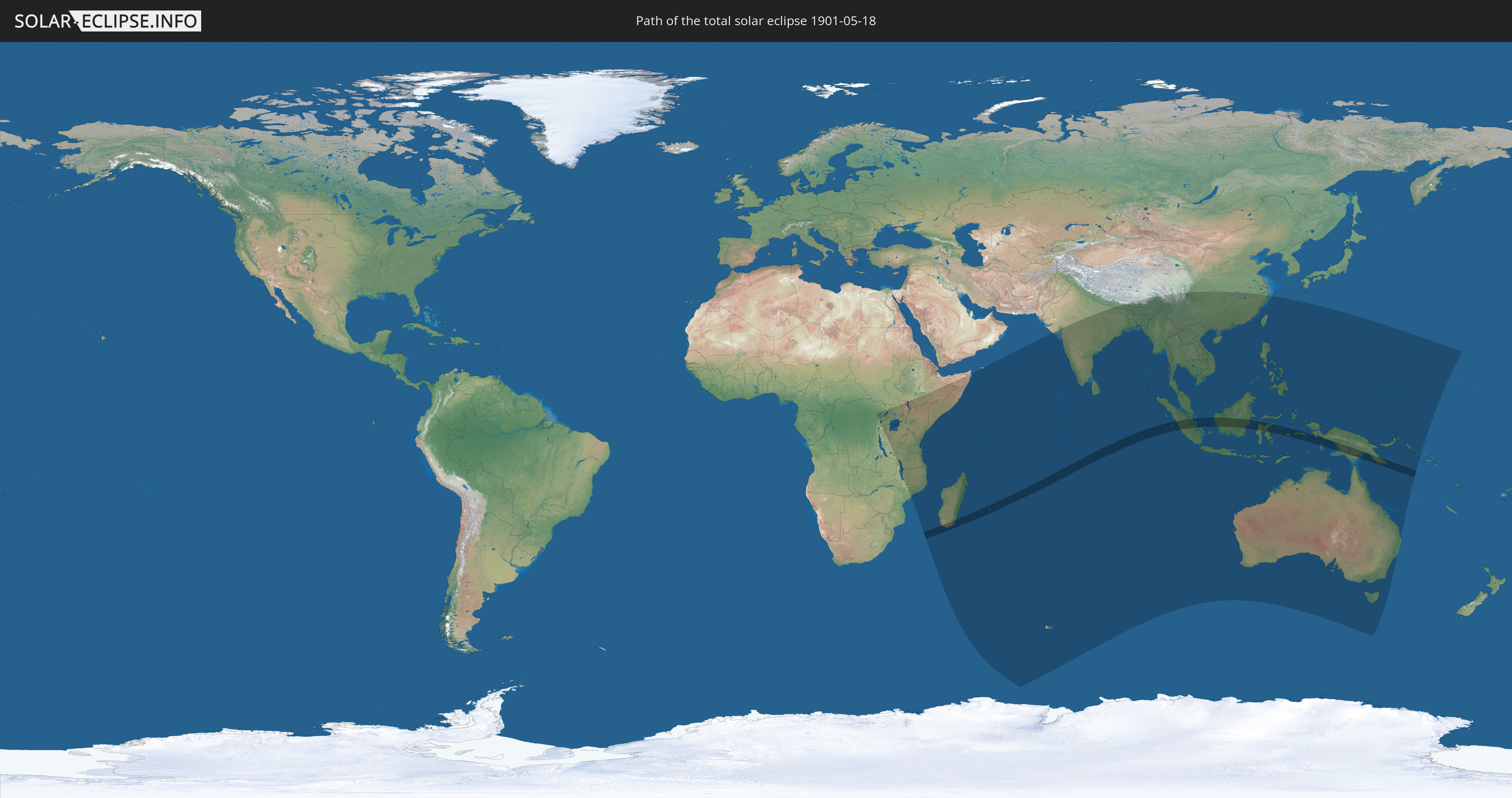
Die Sonnenfinsternis am 18.05.1901 kann man in 52 Ländern als partielle Sonnenfinsternis beobachten.
Der Finsternispfad verläuft durch 5 Länder. Nur in diesen Ländern ist sie als totale Sonnenfinsternis zu sehen.
In den folgenden Ländern ist die Sonnenfinsternis total zu sehen
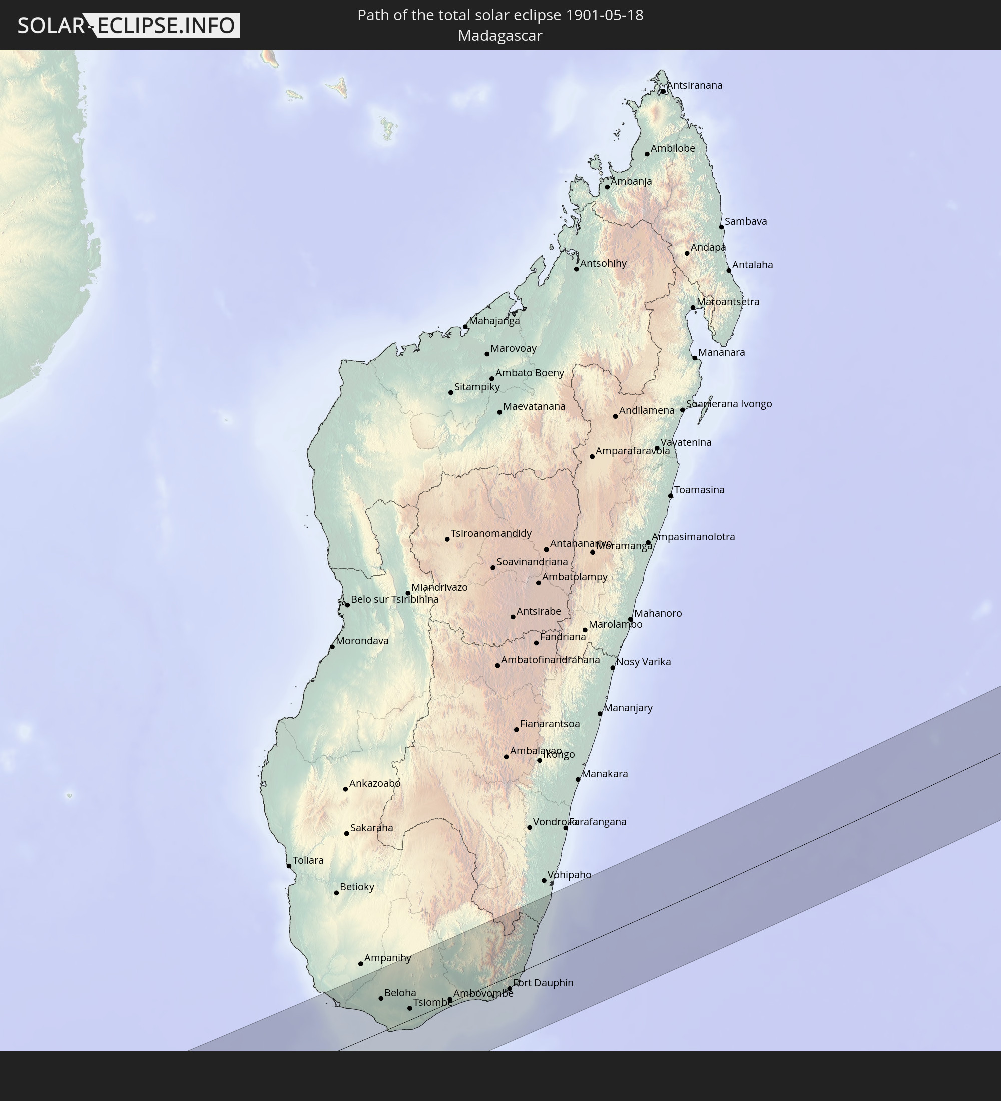 Madagaskar
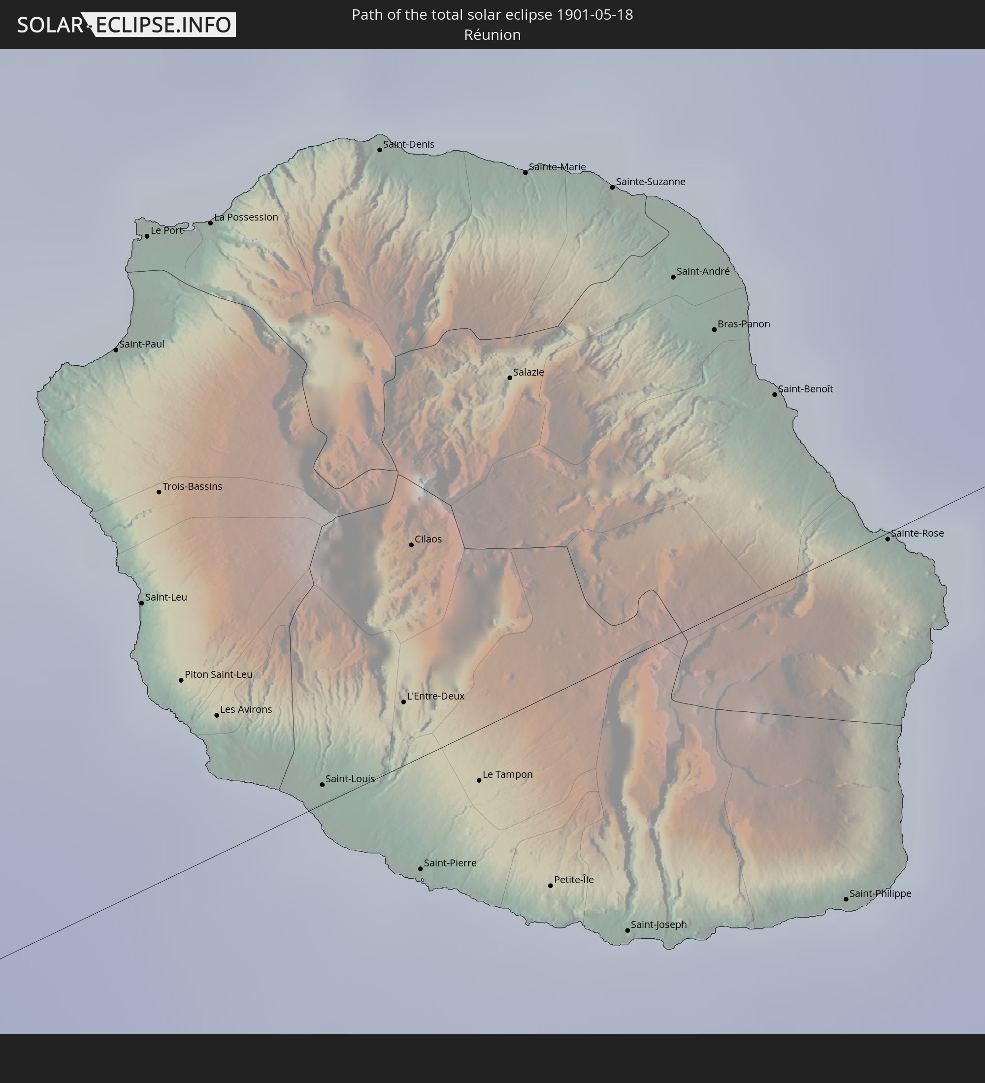 Réunion
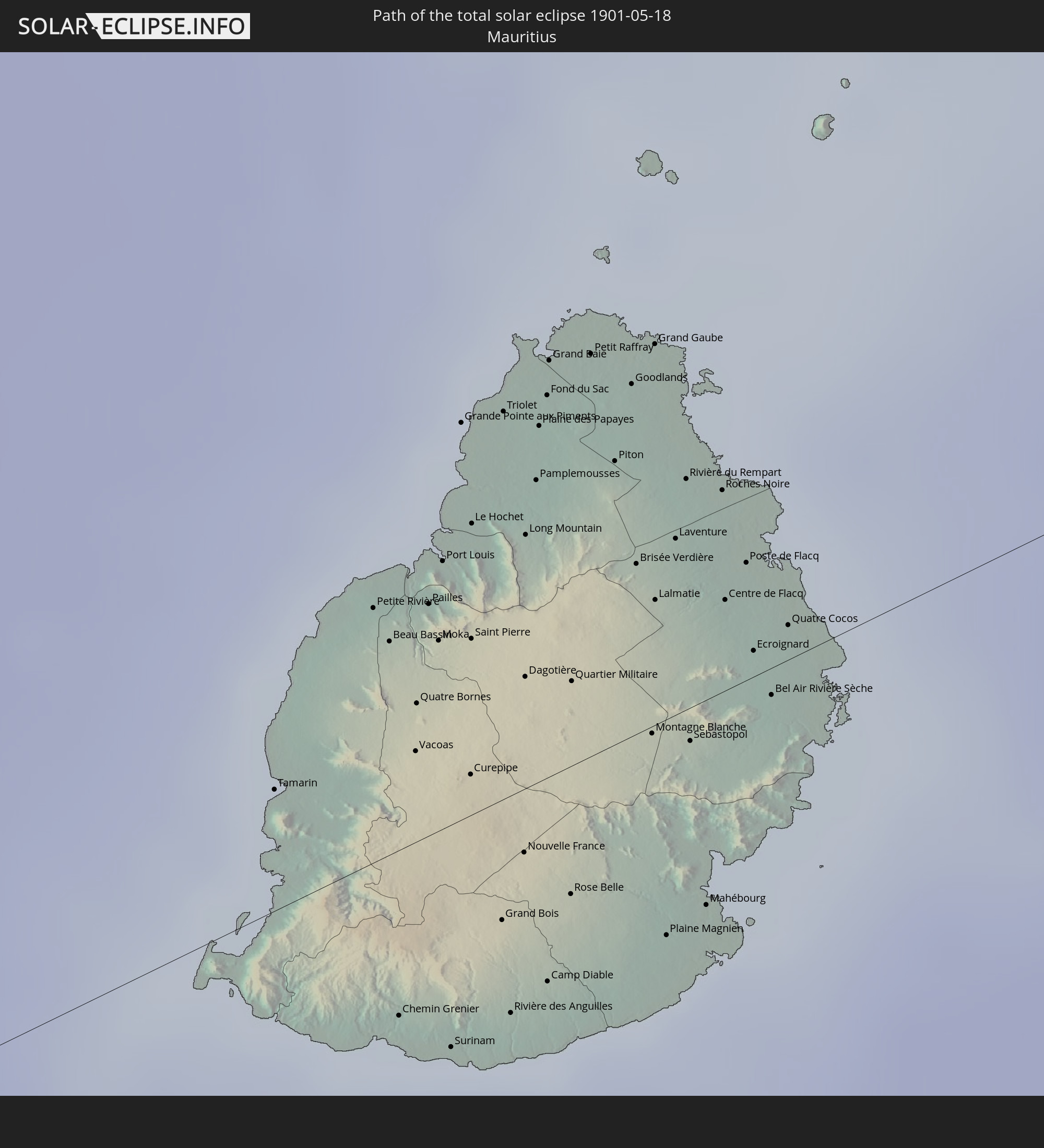 Mauritius
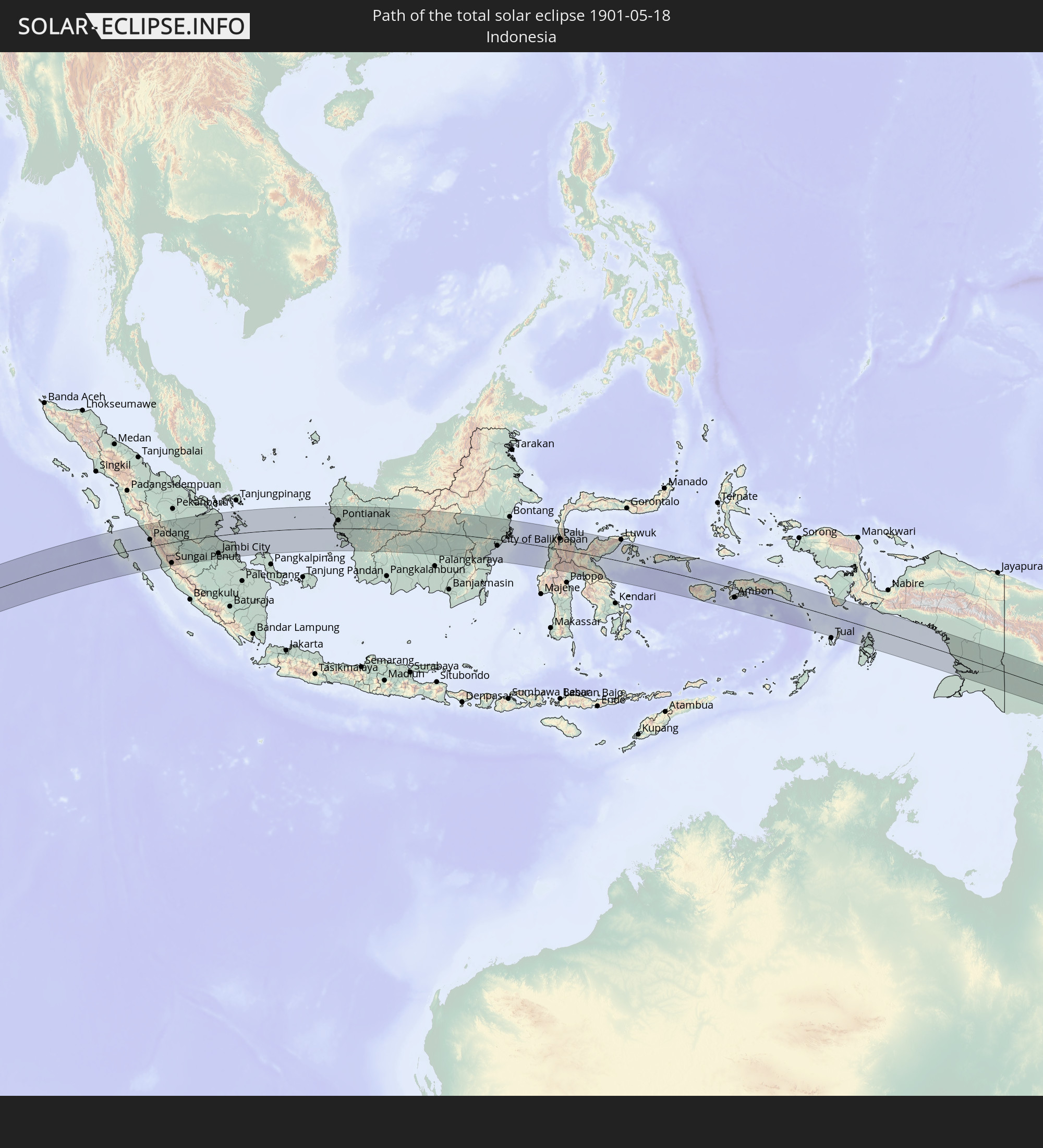 Indonesien
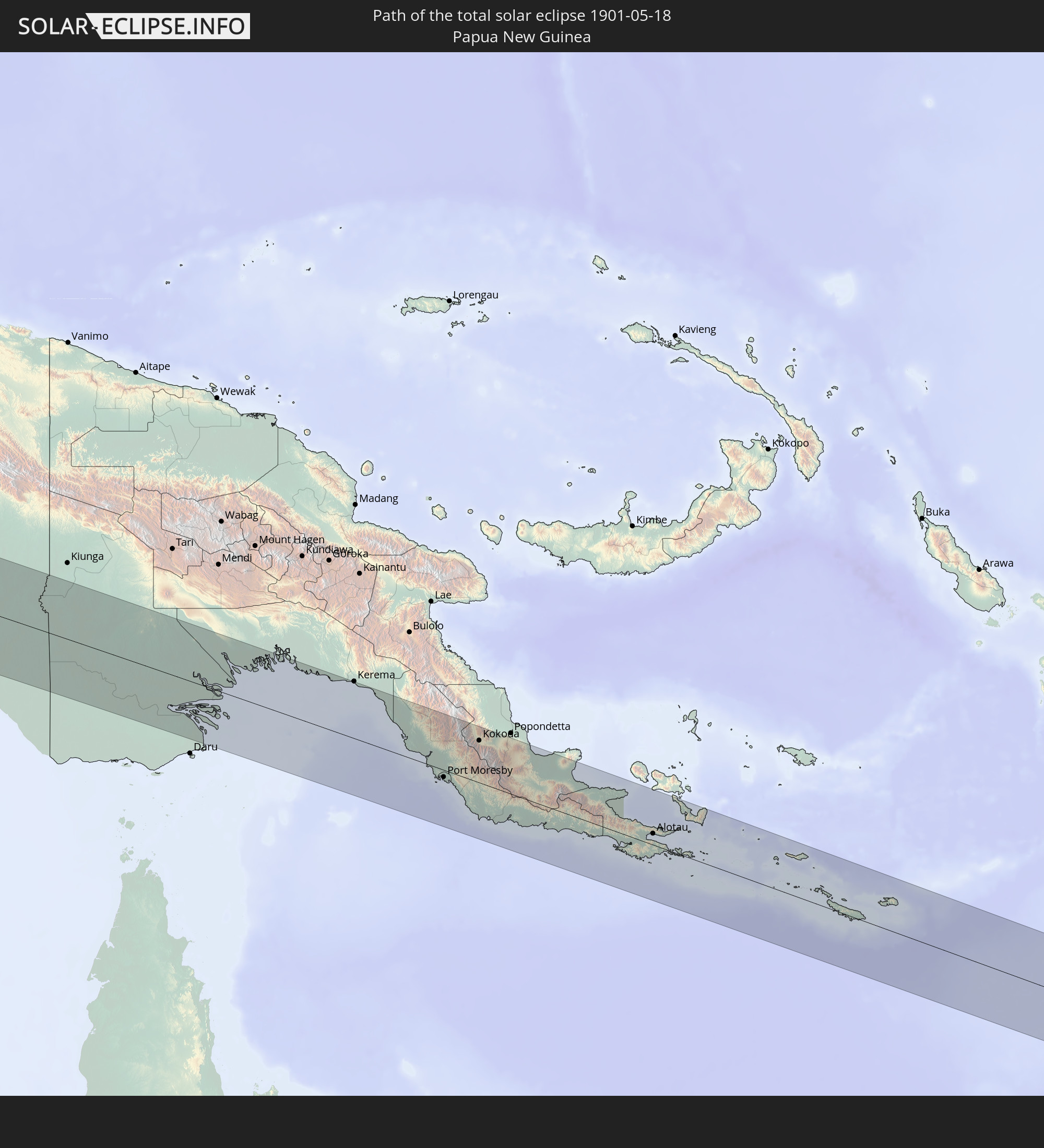 Papua-Neuguinea
In den folgenden Ländern ist die Sonnenfinsternis partiell zu sehen
 Demokratische Republik Kongo
 Ruanda
 Burundi
 Tansania
 Uganda
 Mosambik
 Malawi
 Äthiopien
 Kenia
Kenia
 Französische Süd- und Antarktisgebiete
 Somalia
 Jemen
Jemen
 Madagaskar
 Komoren
 Mayotte
 Seychellen
 Réunion
 Mauritius
 Indien
 Britisches Territorium im Indischen Ozean
 Heard und McDonaldinseln
 Malediven
 Volksrepublik China
 Sri Lanka
 Nepal
Nepal
 Bangladesch
 Bhutan
 Myanmar
 Indonesien
 Kokosinseln
 Thailand
 Malaysia
 Laos
Laos
 Vietnam
 Kambodscha
 Singapur
 Weihnachtsinsel
 Australien
 Macau
Macau
 Hongkong
 Brunei
 Taiwan
 Philippinen
 Japan
Japan
 Osttimor
 Palau
Palau
 Föderierte Staaten von Mikronesien
 Papua-Neuguinea
 Guam
Guam
 Nördliche Marianen
 Salomonen
 Marshallinseln
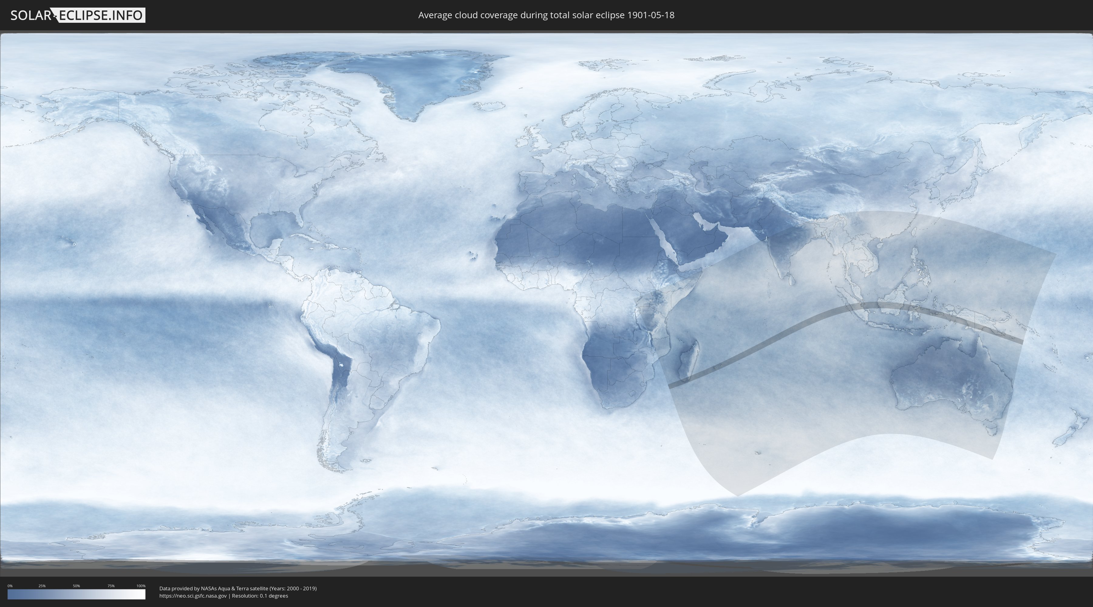
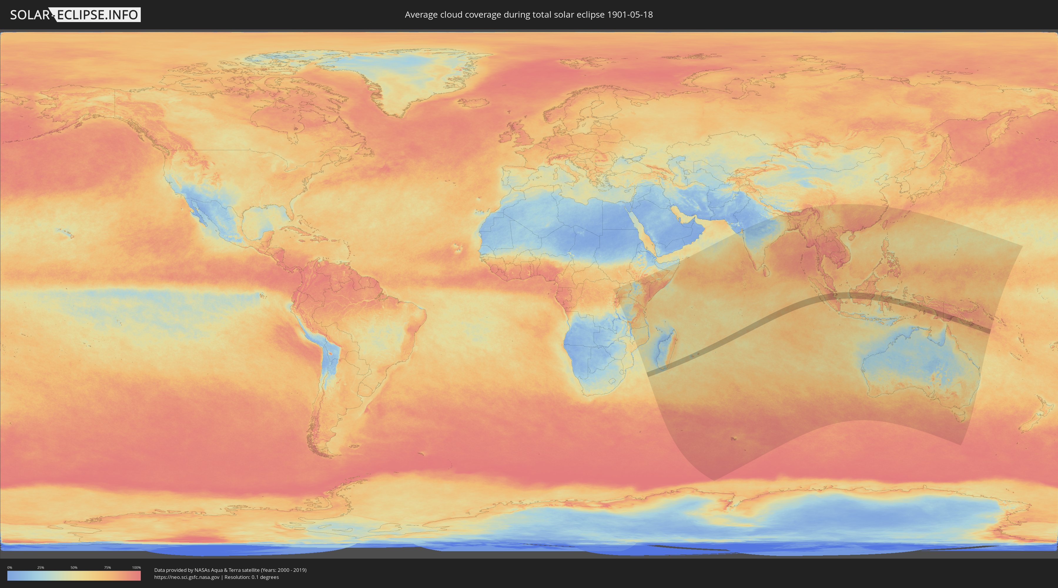
Wie wird das Wetter während der totalen Sonnenfinsternis am 18.05.1901?
Wo ist der beste Ort, um die totale Sonnenfinsternis vom 18.05.1901 zu beobachten?
Die folgenden Karten zeigen die durchschnittliche Bewölkung für den Tag, an dem die totale Sonnenfinsternis
stattfindet. Mit Hilfe der Karten lässt sich der Ort entlang des Finsternispfades eingrenzen,
der die besten Aussichen auf einen klaren wolkenfreien Himmel bietet.
Trotzdem muss man immer lokale Gegenenheiten beachten und sollte sich genau über das Wetter an seinem
gewählten Beobachtungsort informieren.
Die Daten stammen von den beiden NASA-Satelliten
AQUA und TERRA
und wurden über einen Zeitraum von 19 Jahren (2000 - 2019) gemittelt.
Detaillierte Länderkarten
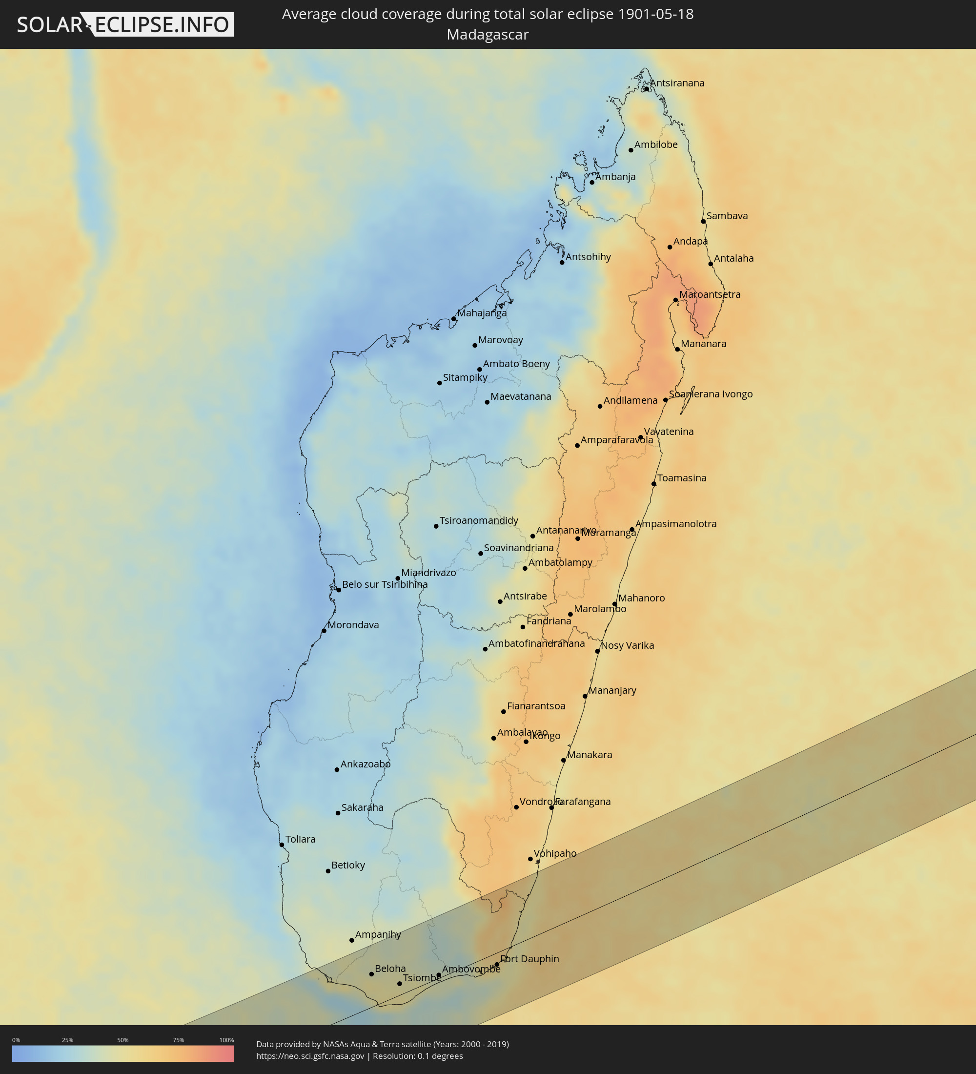 Madagaskar
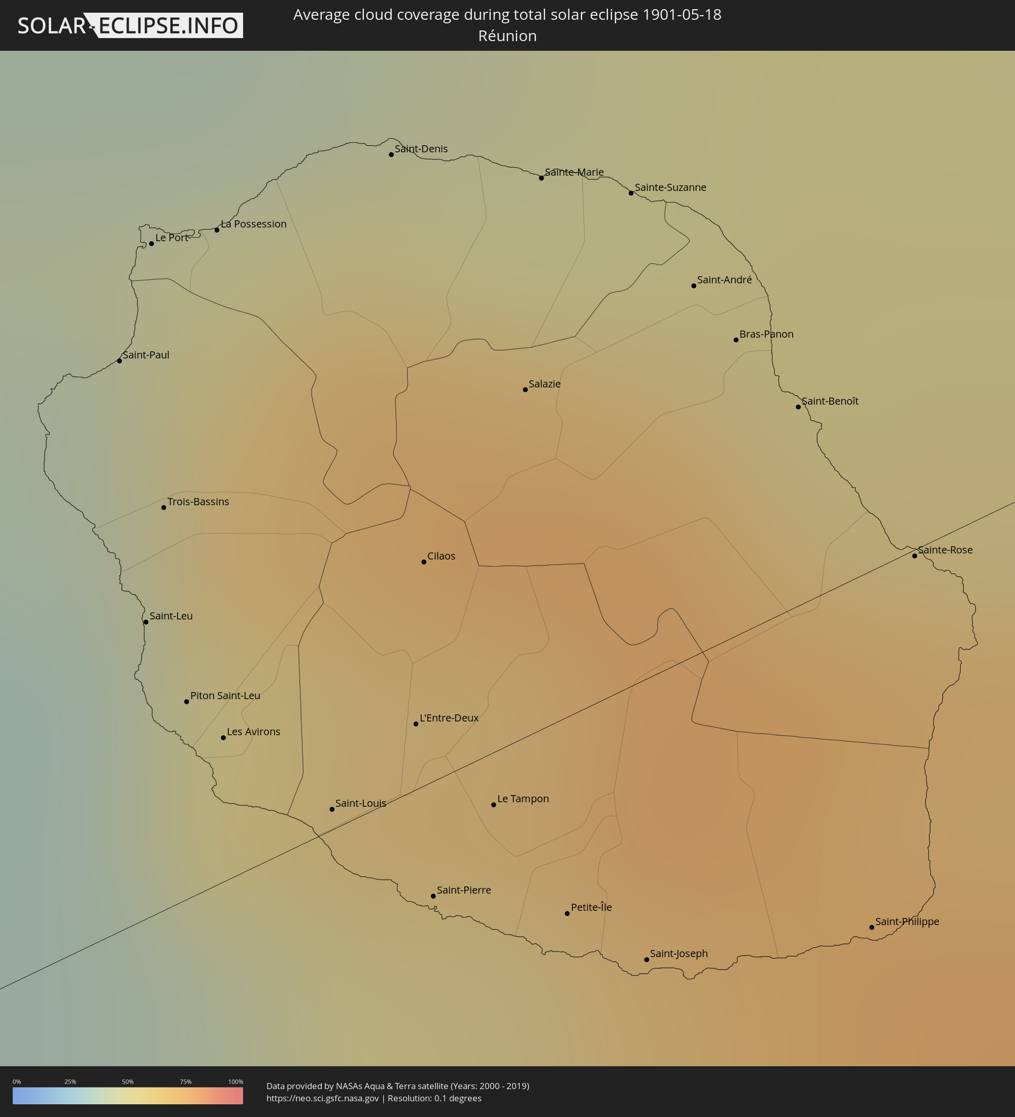 Réunion
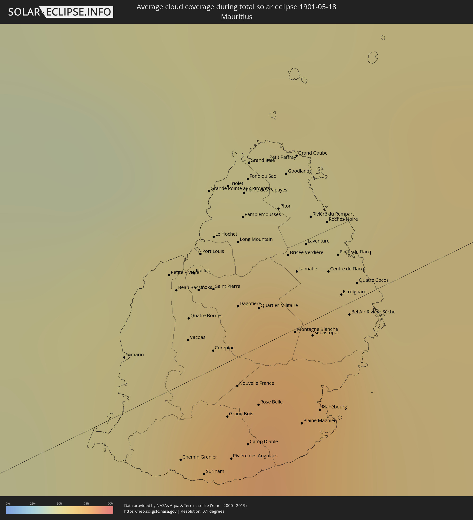 Mauritius
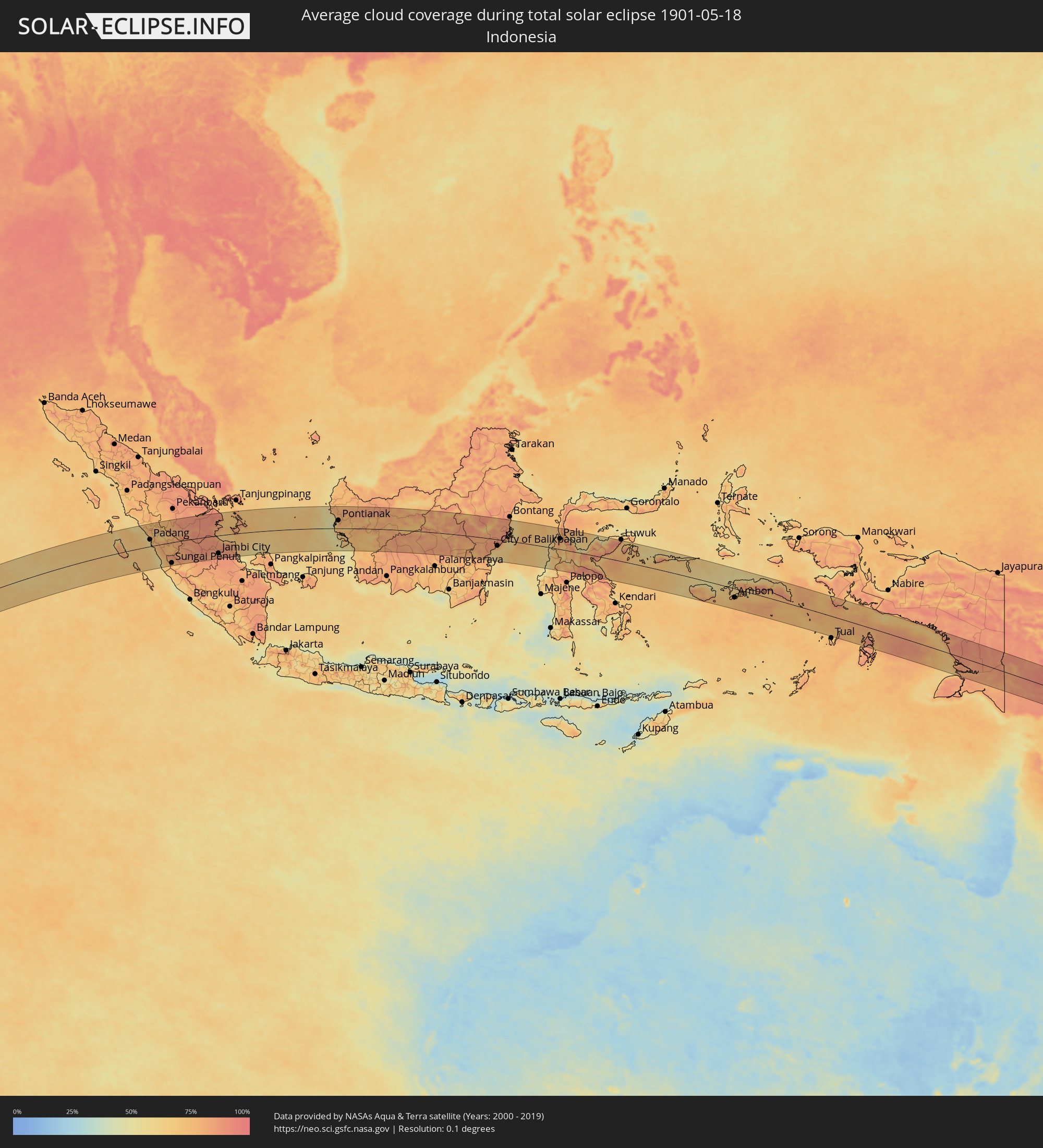 Indonesien
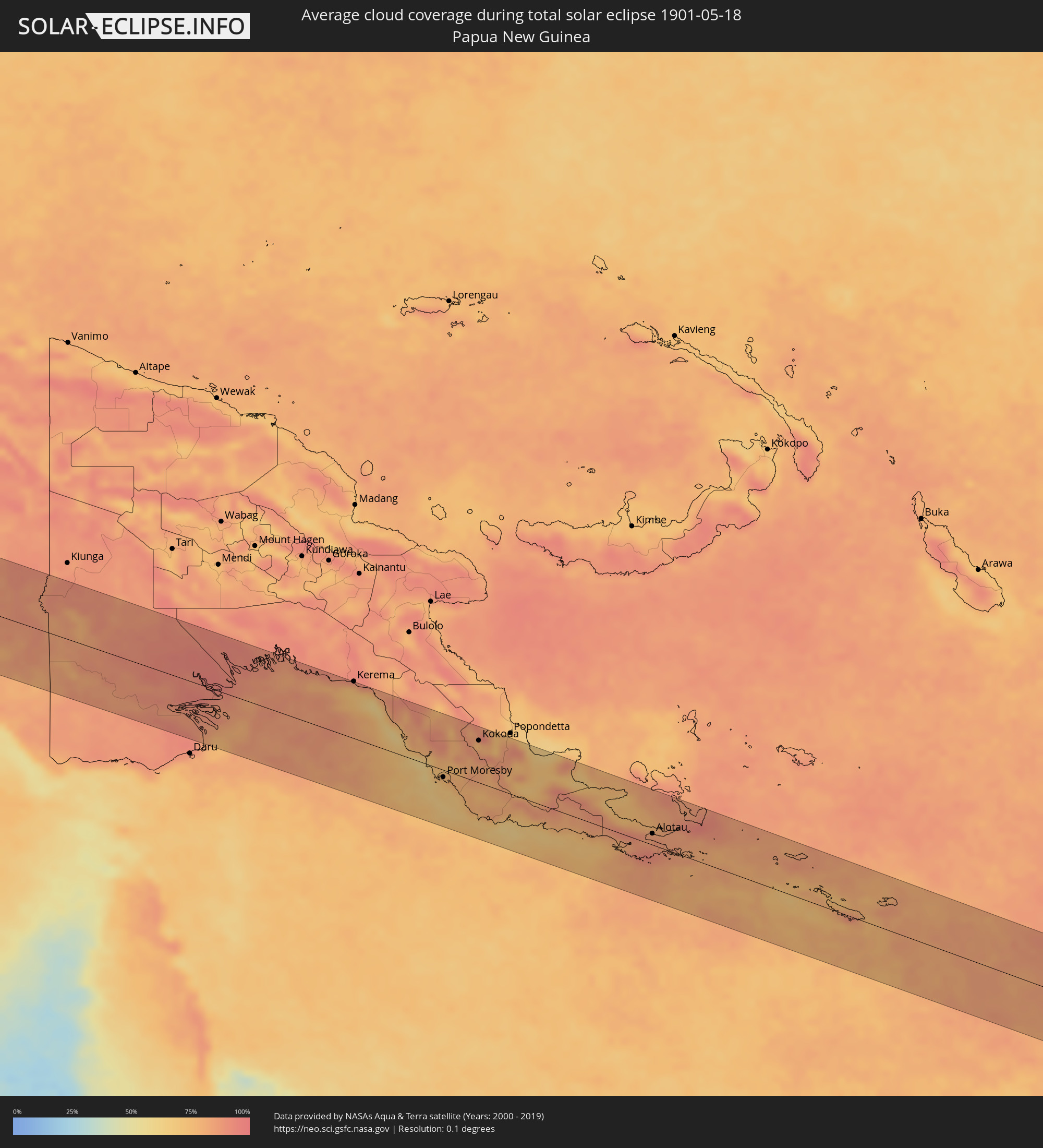 Papua-Neuguinea
Orte im Finsternispfad
Die nachfolgene Tabelle zeigt Städte und Orte mit mehr als 5.000 Einwohnern, die sich im Finsternispfad befinden. Städte mit mehr als 100.000 Einwohnern sind dick gekennzeichnet. Mit einem Klick auf den Ort öffnet sich eine Detailkarte die die Lage des jeweiligen Ortes zusammen mit dem Verlauf der zentralen Finsternis präsentiert.
| Ort | Typ | Dauer der Verfinsterung | Ortszeit bei maximaler Verfinsterung | Entfernung zur Zentrallinie | Ø Bewölkung |
|
Tranovaho, Androy
|
total | - | 06:25:00 UTC+02:27 | 36 km | 47% |
|
Beloha, Androy
|
total | - | 06:24:59 UTC+02:27 | 46 km | 51% |
|
Kopoky, Androy
|
total | - | 06:25:02 UTC+02:27 | 37 km | 50% |
|
Tsiombe, Androy
|
total | - | 06:25:09 UTC+02:27 | 15 km | 51% |
|
Ambovombe, Androy
|
total | - | 06:25:18 UTC+02:27 | 3 km | 42% |
|
Amboasary, Anosy
|
total | - | 06:25:21 UTC+02:27 | 6 km | 41% |
|
Fort Dauphin, Anosy
|
total | - | 06:25:33 UTC+02:27 | 18 km | 47% |
|
Saint-Paul, Réunion
|
total | - | 07:43:32 UTC+03:41 | 35 km | 60% |
|
Saint-Leu, Réunion
|
total | - | 07:43:33 UTC+03:41 | 18 km | 42% |
|
Le Port, Réunion
|
total | - | 07:43:32 UTC+03:41 | 42 km | 56% |
|
Trois-Bassins, Réunion
|
total | - | 07:43:33 UTC+03:41 | 25 km | 53% |
|
Piton Saint-Leu, Réunion
|
total | - | 07:43:35 UTC+03:41 | 12 km | 42% |
|
La Possession, Réunion
|
total | - | 07:43:34 UTC+03:41 | 40 km | 56% |
|
Les Avirons, Réunion
|
total | - | 07:43:36 UTC+03:41 | 9 km | 42% |
|
Saint-Louis, Réunion
|
total | - | 07:43:39 UTC+03:41 | 1 km | 41% |
|
Saint-Denis, Réunion
|
total | - | 07:43:38 UTC+03:41 | 40 km | 66% |
|
L'Entre-Deux, Réunion
|
total | - | 07:43:41 UTC+03:41 | 4 km | 56% |
|
Cilaos, Réunion
|
total | - | 07:43:40 UTC+03:41 | 14 km | 65% |
|
Saint-Pierre, Réunion
|
total | - | 07:43:42 UTC+03:41 | 7 km | 45% |
|
Le Tampon, Réunion
|
total | - | 07:43:43 UTC+03:41 | 3 km | 45% |
|
Salazie, Réunion
|
total | - | 07:43:43 UTC+03:41 | 21 km | 75% |
|
Sainte-Marie, Réunion
|
total | - | 07:43:42 UTC+03:41 | 34 km | 66% |
|
Petite-Île, Réunion
|
total | - | 07:43:46 UTC+03:41 | 12 km | 48% |
|
Sainte-Suzanne, Réunion
|
total | - | 07:43:45 UTC+03:41 | 30 km | 62% |
|
Saint-Joseph, Réunion
|
total | - | 07:43:48 UTC+03:41 | 17 km | 48% |
|
Saint-André, Réunion
|
total | - | 07:43:47 UTC+03:41 | 23 km | 61% |
|
Bras-Panon, Réunion
|
total | - | 07:43:48 UTC+03:41 | 18 km | 61% |
|
Saint-Benoît, Réunion
|
total | - | 07:43:50 UTC+03:41 | 12 km | 61% |
|
Saint-Philippe, Réunion
|
total | - | 07:43:54 UTC+03:41 | 22 km | 55% |
|
Sainte-Rose, Réunion
|
total | - | 07:43:54 UTC+03:41 | 1 km | 69% |
|
Chemin Grenier, Savanne
|
total | - | 07:53:11 UTC+03:50 | 12 km | 64% |
|
Vacoas, Plaines Wilhems
|
total | - | 07:53:11 UTC+03:50 | 7 km | 73% |
|
Pailles, Moka
|
total | - | 07:53:11 UTC+03:50 | 17 km | 65% |
|
Moka, Moka
|
total | - | 07:53:12 UTC+03:50 | 14 km | 65% |
|
Port Louis, Port Louis
|
total | - | 07:53:11 UTC+03:50 | 19 km | 65% |
|
Surinam, Savanne
|
total | - | 07:53:13 UTC+03:50 | 16 km | 64% |
|
Grande Pointe aux Piments, Pamplemousses
|
total | - | 07:53:12 UTC+03:50 | 28 km | 59% |
|
Terre Rouge, Pamplemousses
|
total | - | 07:53:13 UTC+03:50 | 22 km | 59% |
|
Grand Bois, Savanne
|
total | - | 07:53:14 UTC+03:50 | 9 km | 72% |
|
Rivière des Anguilles, Savanne
|
total | - | 07:53:15 UTC+03:50 | 16 km | 64% |
|
Morcellemont Saint André, Pamplemousses
|
total | - | 07:53:14 UTC+03:50 | 25 km | 69% |
|
Nouvelle France, Grand Port
|
total | - | 07:53:15 UTC+03:50 | 5 km | 72% |
|
Dagotière, Moka
|
total | - | 07:53:15 UTC+03:50 | 8 km | 76% |
|
Long Mountain, Pamplemousses
|
total | - | 07:53:14 UTC+03:50 | 18 km | 69% |
|
Pamplemousses, Pamplemousses
|
total | - | 07:53:15 UTC+03:50 | 22 km | 69% |
|
Plaine des Papayes, Pamplemousses
|
total | - | 07:53:15 UTC+03:50 | 25 km | 69% |
|
Fond du Sac, Pamplemousses
|
total | - | 07:53:15 UTC+03:50 | 27 km | 56% |
|
Grand Baie, Rivière du Rempart
|
total | - | 07:53:15 UTC+03:50 | 30 km | 56% |
|
Rose Belle, Grand Port
|
total | - | 07:53:17 UTC+03:50 | 9 km | 72% |
|
Quartier Militaire, Moka
|
total | - | 07:53:16 UTC+03:50 | 6 km | 76% |
|
Petit Raffray, Rivière du Rempart
|
total | - | 07:53:16 UTC+03:50 | 29 km | 56% |
|
New Grove, Grand Port
|
total | - | 07:53:18 UTC+03:50 | 11 km | 72% |
|
Piton, Rivière du Rempart
|
total | - | 07:53:17 UTC+03:50 | 20 km | 69% |
|
Goodlands, Rivière du Rempart
|
total | - | 07:53:18 UTC+03:50 | 25 km | 56% |
|
Brisée Verdière, Flacq
|
total | - | 07:53:18 UTC+03:50 | 12 km | 76% |
|
Bon Accueil, Flacq
|
total | - | 07:53:19 UTC+03:50 | 11 km | 74% |
|
Montagne Blanche
|
total | - | 07:53:19 UTC+03:50 | 1 km | 72% |
|
Grand Gaube, Rivière du Rempart
|
total | - | 07:53:18 UTC+03:50 | 27 km | 53% |
|
Lalmatie, Flacq
|
total | - | 07:53:19 UTC+03:50 | 9 km | 74% |
|
Plaine Magnien, Grand Port
|
total | - | 07:53:20 UTC+03:50 | 15 km | 65% |
|
Laventure, Flacq
|
total | - | 07:53:20 UTC+03:50 | 13 km | 66% |
|
Rivière du Rempart, Rivière du Rempart
|
total | - | 07:53:20 UTC+03:50 | 17 km | 66% |
|
Sebastopol, Flacq
|
total | - | 07:53:21 UTC+03:50 | 2 km | 72% |
|
Beau Vallon, Grand Port
|
total | - | 07:53:21 UTC+03:50 | 16 km | 65% |
|
Mahébourg, Grand Port
|
total | - | 07:53:22 UTC+03:50 | 15 km | 65% |
|
Roches Noire, Rivière du Rempart
|
total | - | 07:53:21 UTC+03:50 | 14 km | 66% |
|
Centre de Flacq, Flacq
|
total | - | 07:53:22 UTC+03:50 | 6 km | 74% |
|
Poste de Flacq, Flacq
|
total | - | 07:53:22 UTC+03:50 | 8 km | 74% |
|
Ecroignard, Flacq
|
total | - | 07:53:23 UTC+03:50 | 2 km | 74% |
|
Quatre Cocos, Flacq
|
total | - | 07:53:24 UTC+03:50 | 2 km | 61% |
|
Pariaman, West Sumatra
|
total | - | 12:47:05 UTC+07:07 | 76 km | 60% |
|
Padang, West Sumatra
|
total | - | 12:47:37 UTC+07:07 | 35 km | 73% |
|
Bukittinggi, West Sumatra
|
total | - | 12:48:05 UTC+07:07 | 105 km | 79% |
|
Payakumbuh, West Sumatra
|
total | - | 12:48:58 UTC+07:07 | 110 km | 72% |
|
Solok, West Sumatra
|
total | - | 12:48:40 UTC+07:07 | 45 km | 73% |
|
Sijunjung, West Sumatra
|
total | - | 12:49:45 UTC+07:07 | 50 km | 65% |
|
Sungai Penuh, Jambi
|
total | - | 12:50:12 UTC+07:07 | 107 km | 74% |
|
Bejubang Dua, Jambi
|
total | - | 12:56:30 UTC+07:07 | 111 km | 87% |
|
Kuala Tungkal, Jambi
|
total | - | 12:57:31 UTC+07:07 | 5 km | 82% |
|
Mendaha, Jambi
|
total | - | 12:57:49 UTC+07:07 | 29 km | 87% |
|
Jambi City, Jambi
|
total | - | 12:57:34 UTC+07:07 | 94 km | 89% |
|
Simpang, Jambi
|
total | - | 12:59:16 UTC+07:07 | 63 km | 84% |
|
Pontianak, West Kalimantan
|
total | - | 13:15:44 UTC+07:07 | 42 km | 81% |
|
Balikpapan, East Kalimantan
|
total | - | 14:25:50 UTC+07:57 | 37 km | 61% |
|
City of Balikpapan, East Kalimantan
|
total | - | 14:25:59 UTC+07:57 | 33 km | 78% |
|
Loa Janan, East Kalimantan
|
total | - | 14:26:38 UTC+07:57 | 43 km | 90% |
|
Samarinda, East Kalimantan
|
total | - | 14:26:46 UTC+07:57 | 53 km | 86% |
|
Palu, Central Sulawesi
|
total | - | 14:32:55 UTC+07:57 | 55 km | 78% |
|
Poso, Central Sulawesi
|
total | - | 14:34:43 UTC+07:57 | 19 km | 63% |
|
Ambon, Maluku
|
total | - | 16:13:15 UTC+09:22 | 45 km | 75% |
|
Amahai, Maluku
|
total | - | 16:14:27 UTC+09:22 | 14 km | 66% |
|
Port Moresby, National Capital
|
total | - | 17:08:14 UTC+10:00 | 12 km | 74% |
|
Kokoda, Northern Province
|
total | - | 17:08:40 UTC+10:00 | 68 km | 85% |
|
Alotau, Milne Bay
|
total | - | 17:09:24 UTC+10:00 | 18 km | 87% |