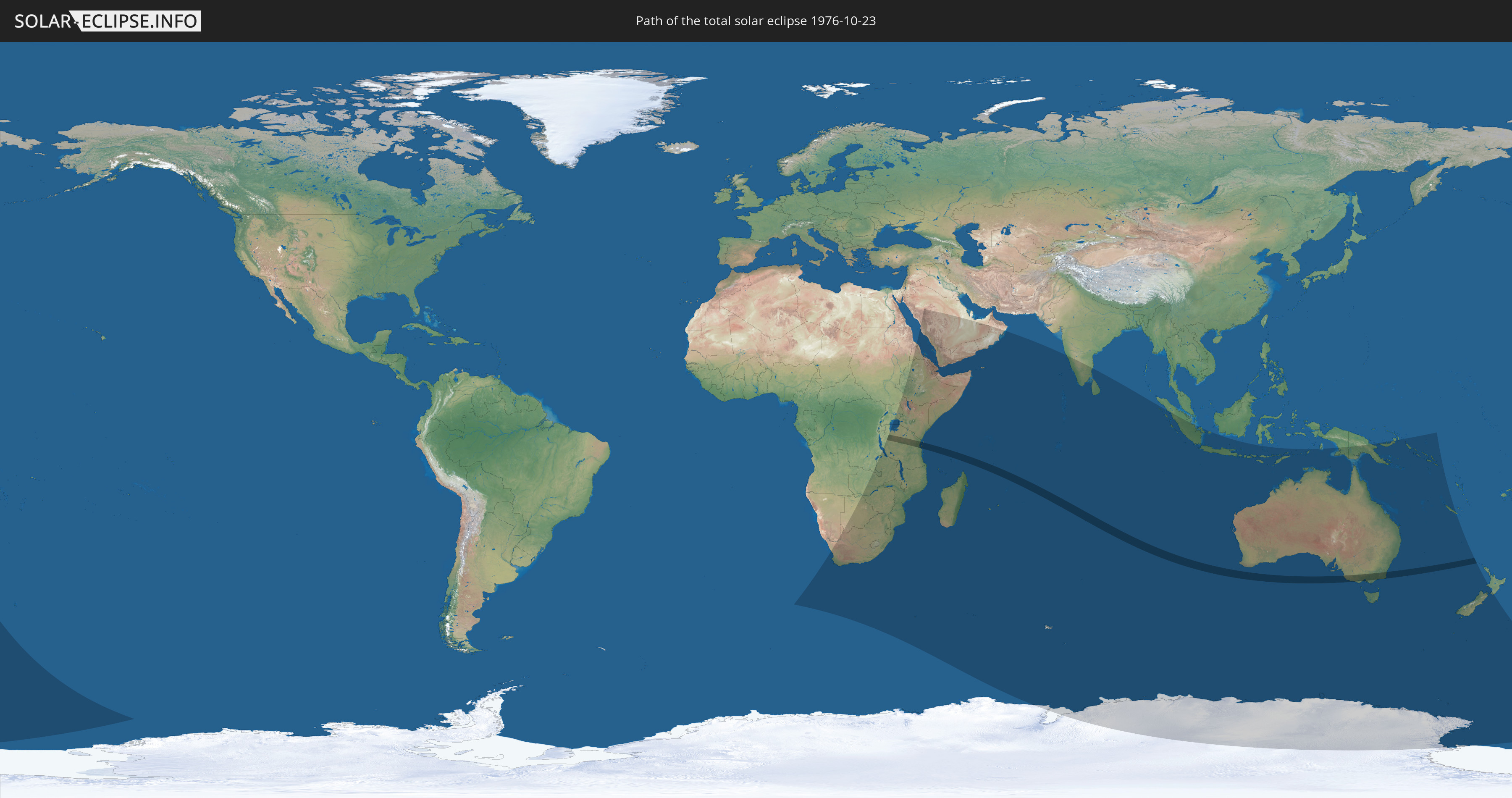
Total solar eclipse of 10/23/1976
Wo kann man die Sonnenfinsternis vom 10/23/1976 sehen?
Die Sonnenfinsternis am 10/23/1976 kann man in 45 Ländern als partielle Sonnenfinsternis beobachten.
Der Finsternispfad verläuft durch 3 Länder. Nur in diesen Ländern ist sie als total Sonnenfinsternis zu sehen.
In den folgenden Ländern ist die Sonnenfinsternis total zu sehen
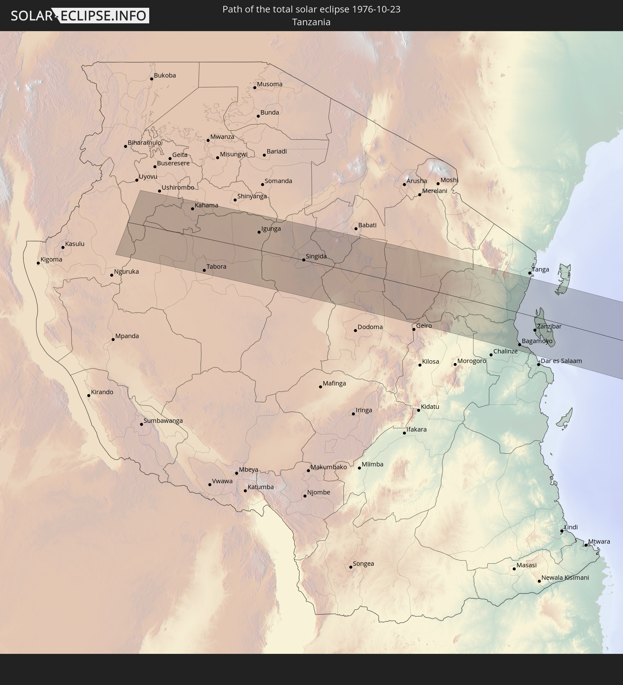 Tanzania
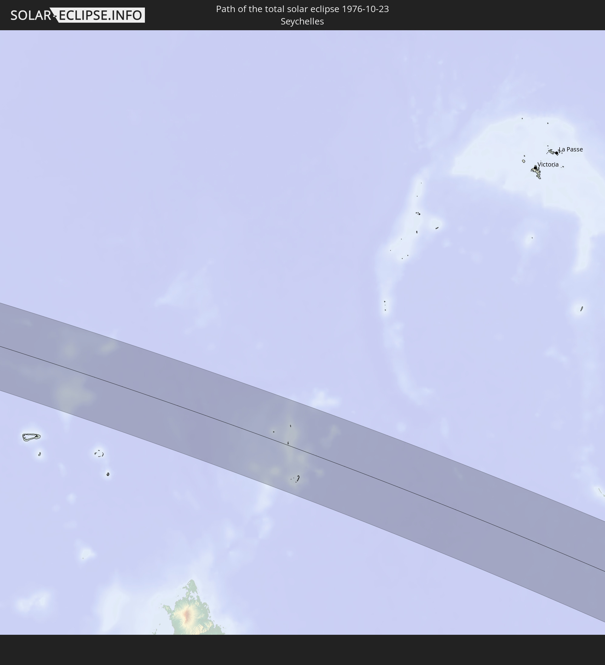 Seychelles
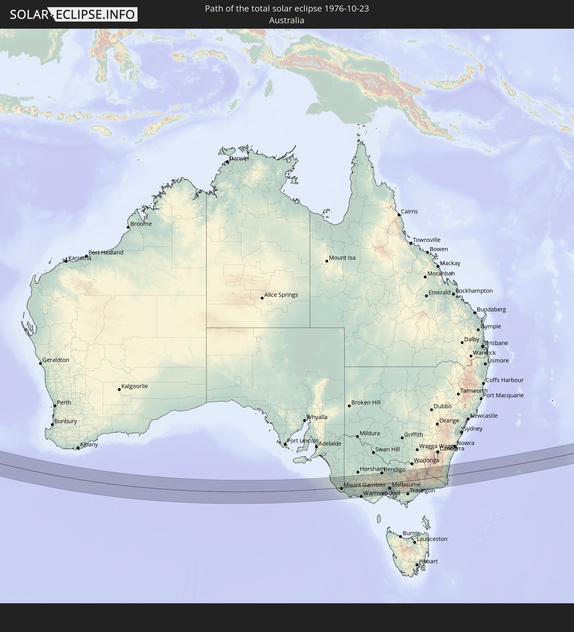 Australia
In den folgenden Ländern ist die Sonnenfinsternis partiell zu sehen
 Antarctica
 New Zealand
 Namibia
 Democratic Republic of the Congo
 South Africa
 Botswana
 Sudan
Sudan
 Zambia
 Zimbabwe
 Lesotho
 Tanzania
 Uganda
 Mozambique
 Swaziland
 Malawi
 Ethiopia
 Kenya
Kenya
 Saudi Arabia
 Eritrea
 French Southern and Antarctic Lands
 Somalia
 Djibouti
 Yemen
Yemen
 Madagascar
 Comoros
 Mayotte
 Seychelles
 United Arab Emirates
 Oman
Oman
 Réunion
 Mauritius
 India
India
 British Indian Ocean Territory
 Heard Island and McDonald Islands
 Maldives
 Sri Lanka
 Indonesia
 Cocos Islands
 Christmas Island
 Australia
 East Timor
 Papua New Guinea
 Solomon Islands
 New Caledonia
 Norfolk Island
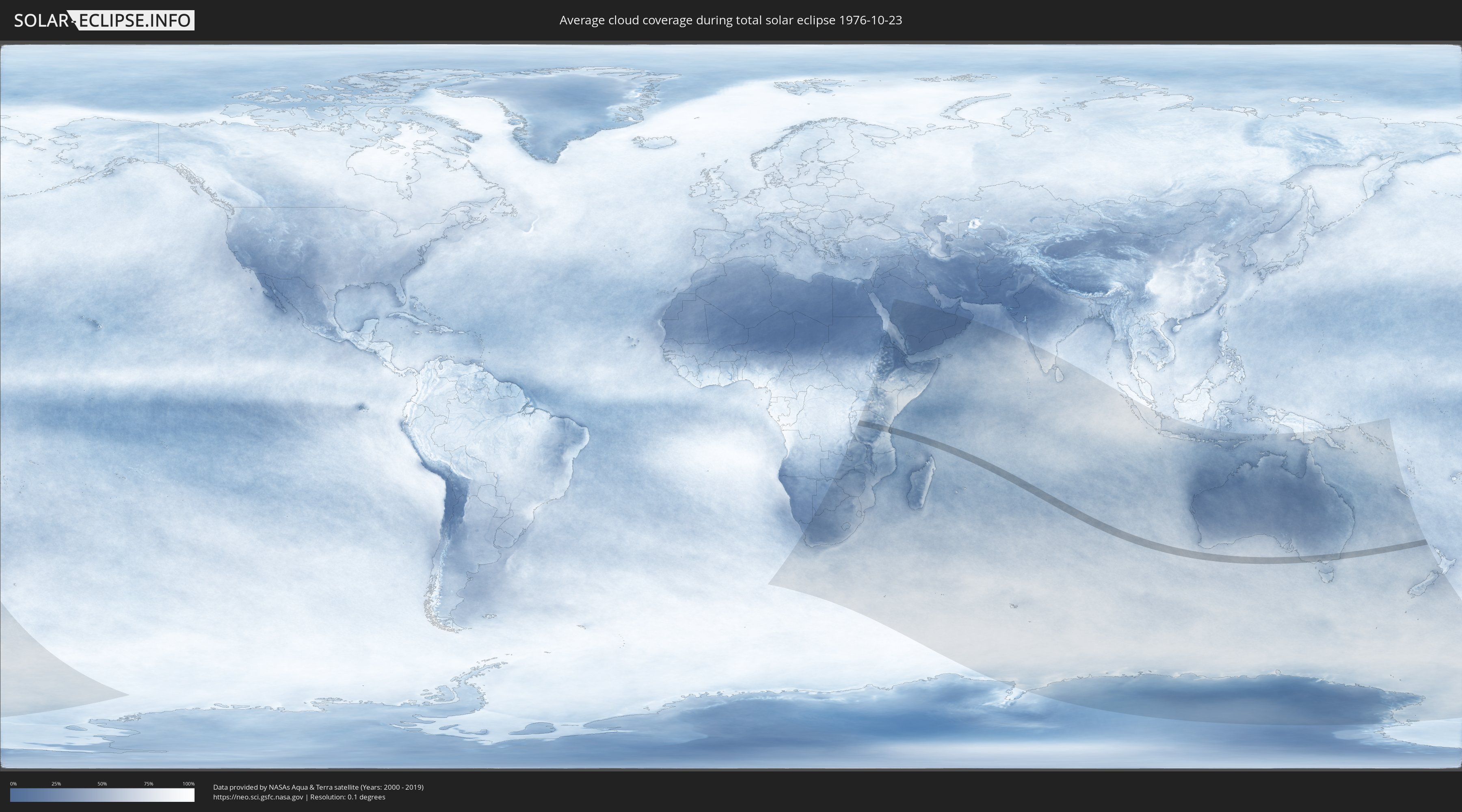
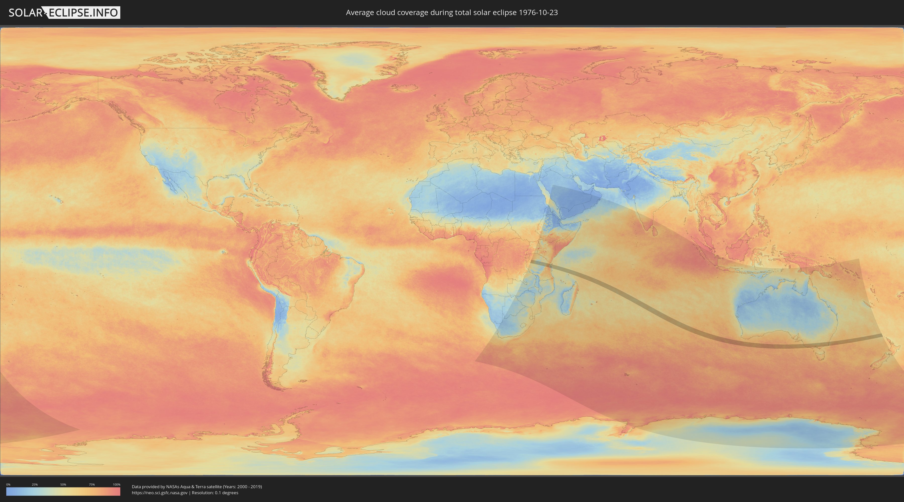
How will be the weather during the total solar eclipse on 10/23/1976?
Where is the best place to see the total solar eclipse of 10/23/1976?
The following maps show the average cloud coverage for the day of the total solar eclipse.
With the help of these maps, it is possible to find the place along the eclipse path, which has the best
chance of a cloudless sky.
Nevertheless, you should consider local circumstances and inform about the weather of your chosen
observation site.
The data is provided by NASAs satellites
AQUA and TERRA.
The cloud maps are averaged over a period of 19 years (2000 - 2019).
Detailed country maps
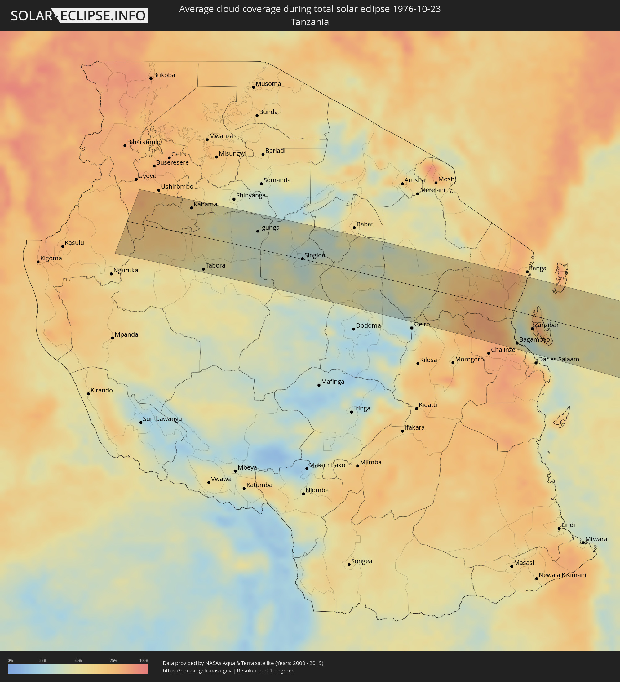 Tanzania
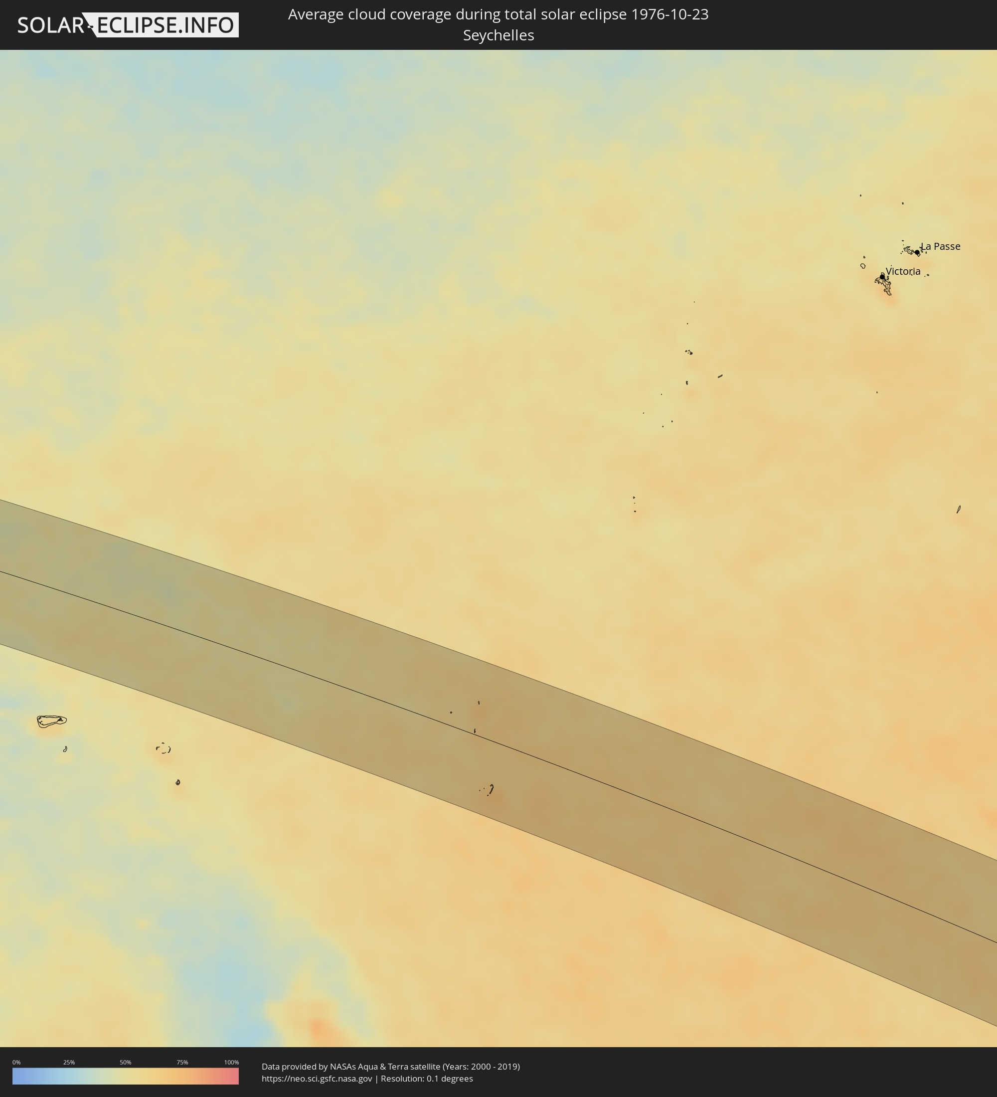 Seychelles
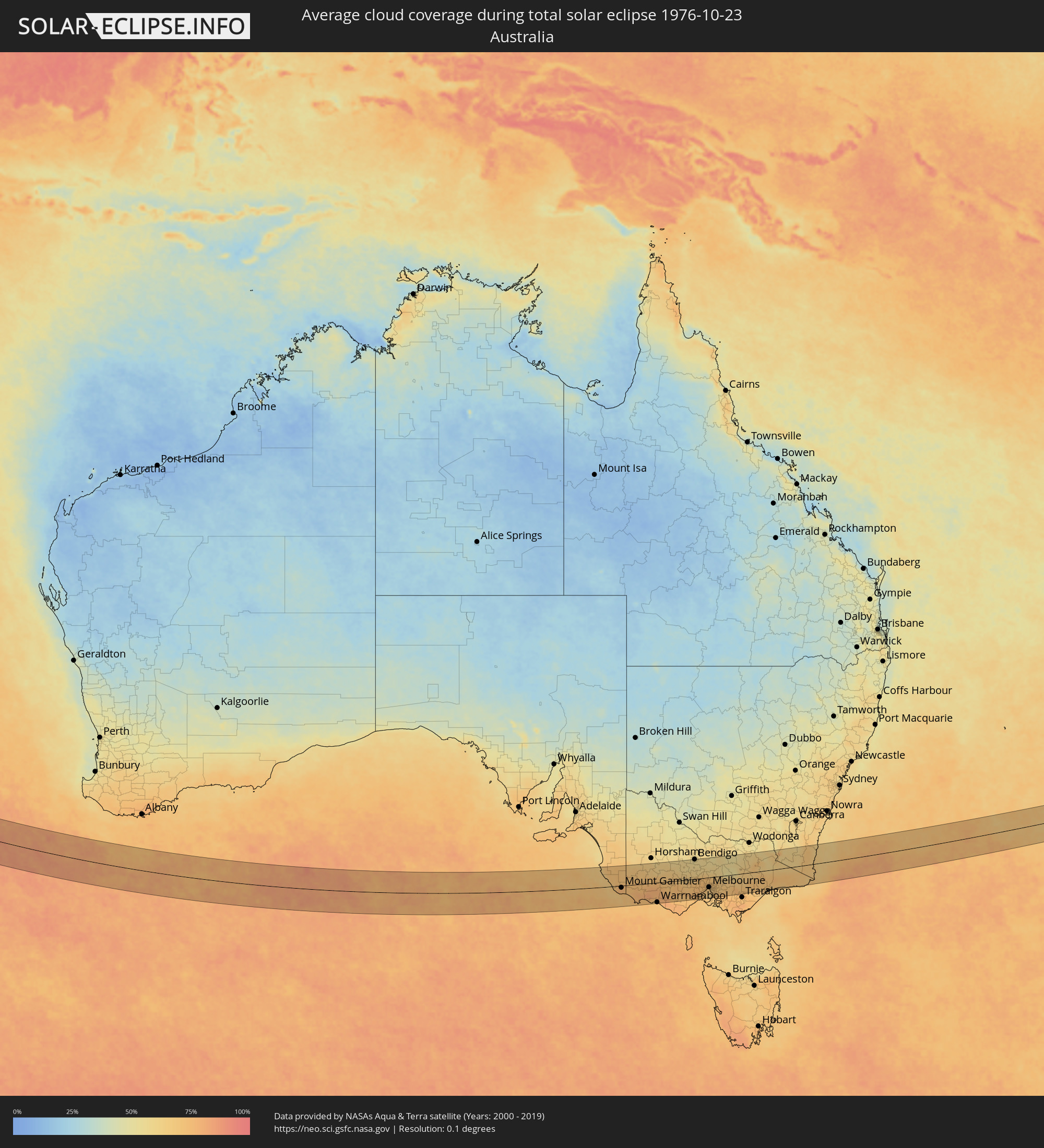 Australia
Cities inside the path of the eclipse
The following table shows all locations with a population of more than 5,000 inside the eclipse path. Cities which have more than 100,000 inhabitants are marked bold. A click at the locations opens a detailed map.
| City | Type | Eclipse duration | Local time of max. eclipse | Distance to central line | Ø Cloud coverage |
|
Masumbwe, Geita
|
total | - | 06:35:16 UTC+03:00 | 68 km | 67% |
|
Kahama, Shinyanga
|
total | - | 06:35:21 UTC+03:00 | 56 km | 58% |
|
Tabora, Tabora
|
total | - | 06:36:10 UTC+03:00 | 68 km | 48% |
|
Bukene, Tabora
|
total | - | 06:35:36 UTC+03:00 | 19 km | 52% |
|
Isaka, Shinyanga
|
total | - | 06:35:22 UTC+03:00 | 56 km | 52% |
|
Nzega, Tabora
|
total | - | 06:35:34 UTC+03:00 | 28 km | 44% |
|
Tinde, Shinyanga
|
total | - | 06:35:20 UTC+03:00 | 64 km | 44% |
|
Igurubi, Tabora
|
total | - | 06:35:22 UTC+03:00 | 63 km | 39% |
|
Igunga, Tabora
|
total | - | 06:35:33 UTC+03:00 | 37 km | 38% |
|
Shelui, Singida
|
total | - | 06:35:36 UTC+03:00 | 35 km | 37% |
|
Ndago, Singida
|
total | - | 06:35:45 UTC+03:00 | 14 km | 35% |
|
Kiomboi, Singida
|
total | - | 06:35:31 UTC+03:00 | 50 km | 41% |
|
Sepuka, Singida
|
total | - | 06:35:51 UTC+03:00 | 2 km | 38% |
|
Igugunu, Singida
|
total | - | 06:35:43 UTC+03:00 | 24 km | 31% |
|
Puma, Singida
|
total | - | 06:36:02 UTC+03:00 | 20 km | 34% |
|
Singida, Singida
|
total | - | 06:35:53 UTC+03:00 | 0 km | 33% |
|
Ikungi, Singida
|
total | - | 06:36:07 UTC+03:00 | 34 km | 36% |
|
Mtinko, Singida
|
total | - | 06:35:41 UTC+03:00 | 31 km | 31% |
|
Ilongero, Singida
|
total | - | 06:35:47 UTC+03:00 | 19 km | 34% |
|
Mungaa, Singida
|
total | - | 06:36:00 UTC+03:00 | 13 km | 39% |
|
Basotu, Manyara
|
total | - | 06:35:33 UTC+03:00 | 57 km | 34% |
|
Nangwa, Manyara
|
total | - | 06:35:36 UTC+03:00 | 55 km | 40% |
|
Endasak, Manyara
|
total | - | 06:35:34 UTC+03:00 | 63 km | 47% |
|
Kondoa, Dodoma
|
total | - | 06:35:55 UTC+03:00 | 17 km | 41% |
|
Kibaya, Manyara
|
total | - | 06:36:13 UTC+03:00 | 6 km | 47% |
|
Chanika, Tanga
|
total | - | 06:36:21 UTC+03:00 | 20 km | 75% |
|
Magomeni, Tanga
|
total | - | 06:36:13 UTC+03:00 | 42 km | 73% |
|
Maramba, Tanga
|
total | - | 06:36:06 UTC+03:00 | 76 km | 79% |
|
Mvomero, Pwani
|
total | - | 06:37:04 UTC+03:00 | 52 km | 72% |
|
Muheza, Tanga
|
total | - | 06:36:12 UTC+03:00 | 68 km | 78% |
|
Bagamoyo, Pwani
|
total | - | 06:37:15 UTC+03:00 | 66 km | 59% |
|
Pangani, Tanga
|
total | - | 06:36:26 UTC+03:00 | 45 km | 50% |
|
Majengo, Tanga
|
total | - | 06:36:12 UTC+03:00 | 75 km | 62% |
|
Zanzibar, Zanzibar Urban/West
|
total | - | 06:37:02 UTC+03:00 | 28 km | 55% |
|
Mkokotoni, Zanzibar North
|
total | - | 06:36:49 UTC+03:00 | 5 km | 71% |
|
Koani, Zanzibar Central/South
|
total | - | 06:37:01 UTC+03:00 | 22 km | 81% |
|
Nungwi, Zanzibar North
|
total | - | 06:36:42 UTC+03:00 | 22 km | 63% |
|
Mahonda, Zanzibar Central/South
|
total | - | 06:37:18 UTC+03:00 | 51 km | 40% |
|
Sokoni, Zanzibar Central/South
|
total | - | 06:37:18 UTC+03:00 | 47 km | 47% |
|
Mtambile, Pemba South
|
total | - | 06:36:27 UTC+03:00 | 70 km | 64% |
|
Mount Gambier, South Australia
|
total | - | 16:07:45 UTC+09:30 | 8 km | 76% |
|
Portland, Victoria
|
total | - | 16:38:00 UTC+10:00 | 71 km | 73% |
|
Hamilton, Victoria
|
total | - | 16:38:47 UTC+10:00 | 8 km | 76% |
|
Warrnambool, Victoria
|
total | - | 16:38:38 UTC+10:00 | 82 km | 70% |
|
Stawell, Victoria
|
total | - | 16:39:51 UTC+10:00 | 63 km | 64% |
|
Ararat, Victoria
|
total | - | 16:39:47 UTC+10:00 | 36 km | 67% |
|
Maryborough, Victoria
|
total | - | 16:40:32 UTC+10:00 | 55 km | 60% |
|
Sebastopol, Victoria
|
total | - | 16:40:12 UTC+10:00 | 5 km | 69% |
|
Ballarat, Victoria
|
total | - | 16:40:13 UTC+10:00 | 3 km | 69% |
|
Castlemaine, Victoria
|
total | - | 16:40:51 UTC+10:00 | 49 km | 61% |
|
Golden Square, Victoria
|
total | - | 16:41:06 UTC+10:00 | 81 km | 57% |
|
Bendigo, Victoria
|
total | - | 16:41:08 UTC+10:00 | 82 km | 57% |
|
Kennington, Victoria
|
total | - | 16:41:07 UTC+10:00 | 79 km | 57% |
|
Hamlyn Heights, Victoria
|
total | - | 16:40:07 UTC+10:00 | 69 km | 75% |
|
Geelong, Victoria
|
total | - | 16:40:07 UTC+10:00 | 72 km | 73% |
|
Leopold, Victoria
|
total | - | 16:40:09 UTC+10:00 | 78 km | 68% |
|
Clifton Springs, Victoria
|
total | - | 16:40:14 UTC+10:00 | 75 km | 69% |
|
Melton South, Victoria
|
total | - | 16:40:36 UTC+10:00 | 26 km | 74% |
|
Melton, Victoria
|
total | - | 16:40:37 UTC+10:00 | 23 km | 74% |
|
Kurunjang, Victoria
|
total | - | 16:40:38 UTC+10:00 | 22 km | 74% |
|
Hoppers Crossing, Victoria
|
total | - | 16:40:33 UTC+10:00 | 46 km | 70% |
|
Sunbury, Victoria
|
total | - | 16:40:48 UTC+10:00 | 13 km | 74% |
|
Truganina, Victoria
|
total | - | 16:40:38 UTC+10:00 | 39 km | 71% |
|
Derrimut, Victoria
|
total | - | 16:40:40 UTC+10:00 | 37 km | 71% |
|
Delahey, Victoria
|
total | - | 16:40:43 UTC+10:00 | 29 km | 72% |
|
Cairnlea, Victoria
|
total | - | 16:40:42 UTC+10:00 | 33 km | 71% |
|
Saint Albans, Victoria
|
total | - | 16:40:43 UTC+10:00 | 31 km | 72% |
|
Keilor, Victoria
|
total | - | 16:40:46 UTC+10:00 | 29 km | 72% |
|
Braybrook, Victoria
|
total | - | 16:40:43 UTC+10:00 | 37 km | 68% |
|
Maidstone, Victoria
|
total | - | 16:40:44 UTC+10:00 | 36 km | 68% |
|
Tullamarine, Victoria
|
total | - | 16:40:48 UTC+10:00 | 28 km | 71% |
|
Airport West, Victoria
|
total | - | 16:40:47 UTC+10:00 | 30 km | 71% |
|
Gladstone Park, Victoria
|
total | - | 16:40:49 UTC+10:00 | 26 km | 71% |
|
Oak Park, Victoria
|
total | - | 16:40:49 UTC+10:00 | 30 km | 71% |
|
Flemington, Victoria
|
total | - | 16:40:46 UTC+10:00 | 38 km | 68% |
|
Parkville, Victoria
|
total | - | 16:40:47 UTC+10:00 | 38 km | 66% |
|
Docklands, Victoria
|
total | - | 16:40:45 UTC+10:00 | 41 km | 66% |
|
Coburg North, Victoria
|
total | - | 16:40:50 UTC+10:00 | 32 km | 70% |
|
Melbourne, Victoria
|
total | - | 16:40:46 UTC+10:00 | 41 km | 66% |
|
South Melbourne, Victoria
|
total | - | 16:40:45 UTC+10:00 | 43 km | 66% |
|
Carlton North, Victoria
|
total | - | 16:40:48 UTC+10:00 | 38 km | 66% |
|
Brunswick East, Victoria
|
total | - | 16:40:48 UTC+10:00 | 37 km | 66% |
|
Fitzroy, Victoria
|
total | - | 16:40:47 UTC+10:00 | 39 km | 66% |
|
Windsor, Victoria
|
total | - | 16:40:45 UTC+10:00 | 46 km | 64% |
|
Clifton Hill, Victoria
|
total | - | 16:40:48 UTC+10:00 | 40 km | 66% |
|
Albert Park, Victoria
|
total | - | 16:40:46 UTC+10:00 | 44 km | 66% |
|
Black Rock, Victoria
|
total | - | 16:40:41 UTC+10:00 | 59 km | 63% |
|
Fairfield, Victoria
|
total | - | 16:40:50 UTC+10:00 | 38 km | 66% |
|
Epping, Victoria
|
total | - | 16:40:56 UTC+10:00 | 24 km | 70% |
|
Ormond, Victoria
|
total | - | 16:40:45 UTC+10:00 | 51 km | 64% |
|
Cheltenham, Victoria
|
total | - | 16:40:42 UTC+10:00 | 59 km | 63% |
|
Kew East, Victoria
|
total | - | 16:40:50 UTC+10:00 | 40 km | 68% |
|
Heidelberg Heights, Victoria
|
total | - | 16:40:53 UTC+10:00 | 34 km | 68% |
|
Murrumbeena, Victoria
|
total | - | 16:40:46 UTC+10:00 | 52 km | 67% |
|
Rosanna, Victoria
|
total | - | 16:40:53 UTC+10:00 | 35 km | 68% |
|
Ashburton, Victoria
|
total | - | 16:40:48 UTC+10:00 | 48 km | 67% |
|
Mordialloc, Victoria
|
total | - | 16:40:42 UTC+10:00 | 63 km | 66% |
|
Hughesdale, Victoria
|
total | - | 16:40:47 UTC+10:00 | 52 km | 67% |
|
Canterbury, Victoria
|
total | - | 16:40:50 UTC+10:00 | 43 km | 68% |
|
Oakleigh South, Victoria
|
total | - | 16:40:46 UTC+10:00 | 54 km | 67% |
|
Viewbank, Victoria
|
total | - | 16:40:54 UTC+10:00 | 34 km | 68% |
|
Mernda, Victoria
|
total | - | 16:41:01 UTC+10:00 | 19 km | 71% |
|
Aspendale, Victoria
|
total | - | 16:40:41 UTC+10:00 | 66 km | 66% |
|
Clarinda, Victoria
|
total | - | 16:40:46 UTC+10:00 | 56 km | 67% |
|
Chelsea, Victoria
|
total | - | 16:40:41 UTC+10:00 | 69 km | 67% |
|
Montmorency, Victoria
|
total | - | 16:40:56 UTC+10:00 | 32 km | 68% |
|
Aspendale Gardens, Victoria
|
total | - | 16:40:42 UTC+10:00 | 66 km | 66% |
|
Box Hill South, Victoria
|
total | - | 16:40:51 UTC+10:00 | 45 km | 68% |
|
Bonbeach, Victoria
|
total | - | 16:40:40 UTC+10:00 | 70 km | 67% |
|
Box Hill, Victoria
|
total | - | 16:40:52 UTC+10:00 | 43 km | 68% |
|
Frankston East, Victoria
|
total | - | 16:40:37 UTC+10:00 | 78 km | 67% |
|
Patterson Lakes, Victoria
|
total | - | 16:40:41 UTC+10:00 | 71 km | 67% |
|
Doncaster East, Victoria
|
total | - | 16:40:54 UTC+10:00 | 40 km | 68% |
|
Eltham North, Victoria
|
total | - | 16:40:58 UTC+10:00 | 30 km | 68% |
|
Blackburn North, Victoria
|
total | - | 16:40:53 UTC+10:00 | 42 km | 68% |
|
Noble Park North, Victoria
|
total | - | 16:40:48 UTC+10:00 | 58 km | 70% |
|
Skye, Victoria
|
total | - | 16:40:42 UTC+10:00 | 76 km | 70% |
|
Rowville, Victoria
|
total | - | 16:40:51 UTC+10:00 | 57 km | 70% |
|
Scoresby, Victoria
|
total | - | 16:40:52 UTC+10:00 | 53 km | 70% |
|
Doveton, Victoria
|
total | - | 16:40:48 UTC+10:00 | 64 km | 72% |
|
Knoxfield, Victoria
|
total | - | 16:40:53 UTC+10:00 | 52 km | 70% |
|
Lynbrook, Victoria
|
total | - | 16:40:46 UTC+10:00 | 71 km | 71% |
|
Cranbourne West, Victoria
|
total | - | 16:40:44 UTC+10:00 | 75 km | 71% |
|
Cranbourne East, Victoria
|
total | - | 16:40:44 UTC+10:00 | 78 km | 71% |
|
Bayswater North, Victoria
|
total | - | 16:40:58 UTC+10:00 | 46 km | 69% |
|
Croydon North, Victoria
|
total | - | 16:41:00 UTC+10:00 | 41 km | 69% |
|
Lysterfield, Victoria
|
total | - | 16:40:53 UTC+10:00 | 58 km | 70% |
|
Chirnside Park, Victoria
|
total | - | 16:41:03 UTC+10:00 | 36 km | 70% |
|
Narre Warren North, Victoria
|
total | - | 16:40:51 UTC+10:00 | 63 km | 72% |
|
Upwey, Victoria
|
total | - | 16:40:56 UTC+10:00 | 54 km | 70% |
|
Lilydale, Victoria
|
total | - | 16:41:04 UTC+10:00 | 38 km | 69% |
|
Montrose, Victoria
|
total | - | 16:41:01 UTC+10:00 | 45 km | 69% |
|
Berwick, Victoria
|
total | - | 16:40:50 UTC+10:00 | 69 km | 73% |
|
Mount Evelyn, Victoria
|
total | - | 16:41:03 UTC+10:00 | 42 km | 69% |
|
Emerald, Victoria
|
total | - | 16:40:59 UTC+10:00 | 59 km | 71% |
|
Pakenham South, Victoria
|
total | - | 16:40:52 UTC+10:00 | 82 km | 74% |
|
Healesville, Victoria
|
total | - | 16:41:15 UTC+10:00 | 29 km | 66% |
|
Bairnsdale, Victoria
|
total | - | 16:42:20 UTC+10:00 | 70 km | 70% |
|
Lakes Entrance, Victoria
|
total | - | 16:42:29 UTC+10:00 | 81 km | 66% |
|
Merimbula, New South Wales
|
total | - | 16:44:15 UTC+10:00 | 5 km | 66% |