Totale Sonnenfinsternis vom 23.10.1976
16 Personen haben diese Sonnenfinsternis beobachtet.
| Wochentag: | Samstag |
| Maximale Dauer der Verfinsterung: | 04m46s |
| Maximale Breite des Finsternispfades: | 199 km |
| Saroszyklus: | 133 |
| Bedeckungsgrad: | 100% |
| Magnitude: | 1.0572 |
| Gamma: | -0.327 |
Wo kann man die Sonnenfinsternis vom 23.10.1976 sehen?
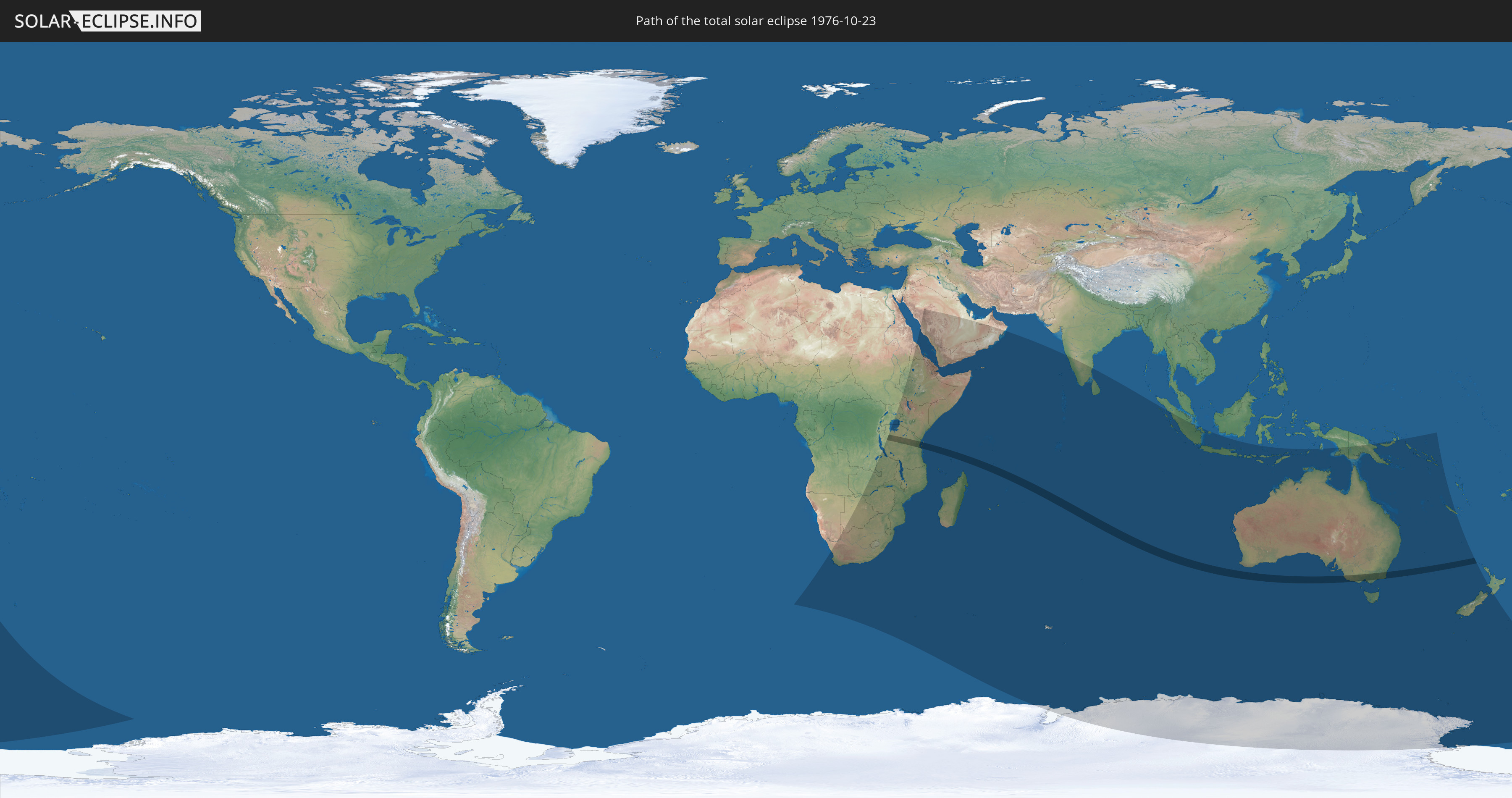
Die Sonnenfinsternis am 23.10.1976 kann man in 45 Ländern als partielle Sonnenfinsternis beobachten.
Der Finsternispfad verläuft durch 3 Länder. Nur in diesen Ländern ist sie als totale Sonnenfinsternis zu sehen.
In den folgenden Ländern ist die Sonnenfinsternis total zu sehen
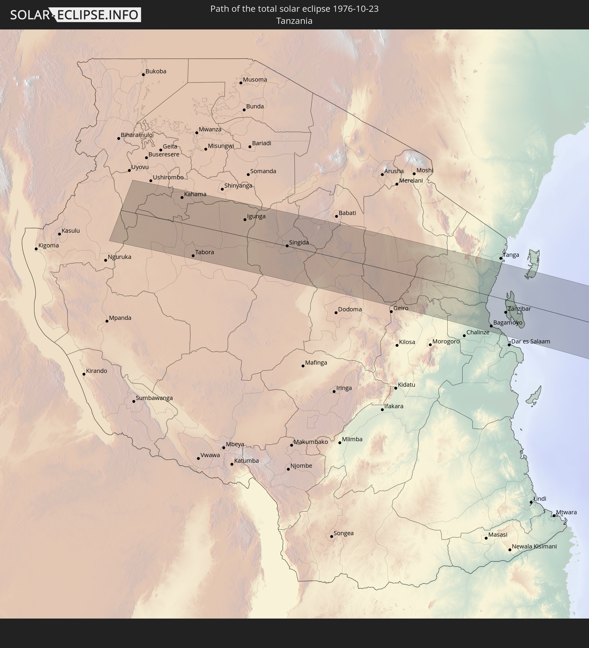 Tansania
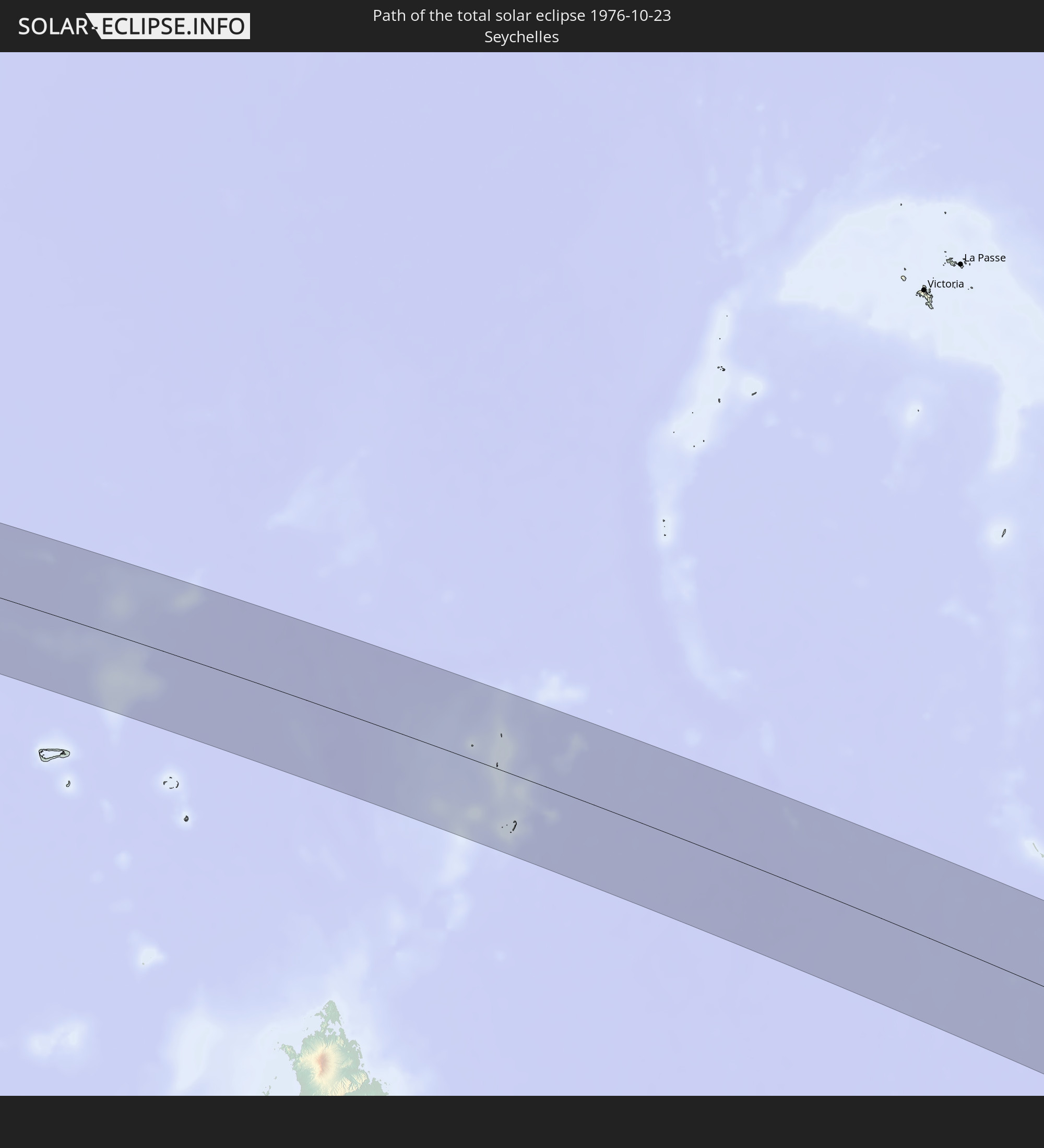 Seychellen
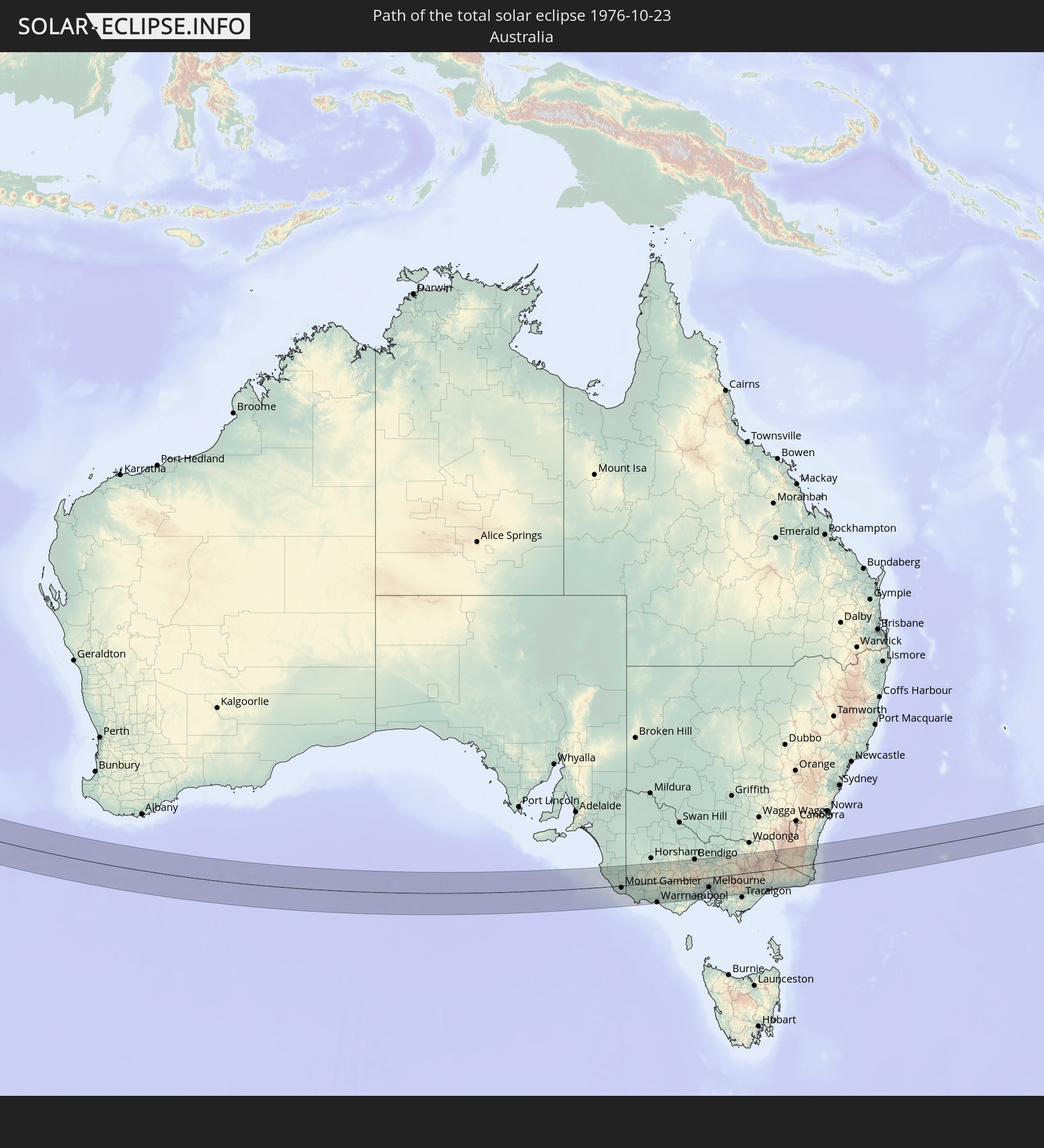 Australien
In den folgenden Ländern ist die Sonnenfinsternis partiell zu sehen
 Antarktika
 Neuseeland
 Namibia
 Demokratische Republik Kongo
 Südafrika
 Botswana
 Sudan
Sudan
 Sambia
 Simbabwe
 Lesotho
 Tansania
 Uganda
 Mosambik
 Swasiland
 Malawi
 Äthiopien
 Kenia
Kenia
 Saudi-Arabien
 Eritrea
 Französische Süd- und Antarktisgebiete
 Somalia
 Dschibuti
 Jemen
Jemen
 Madagaskar
 Komoren
 Mayotte
 Seychellen
 Vereinigte Arabische Emirate
 Oman
Oman
 Réunion
 Mauritius
 Indien
 Britisches Territorium im Indischen Ozean
 Heard und McDonaldinseln
 Malediven
 Sri Lanka
 Indonesien
 Kokosinseln
 Weihnachtsinsel
 Australien
 Osttimor
 Papua-Neuguinea
 Salomonen
 Neukaledonien
 Norfolkinsel
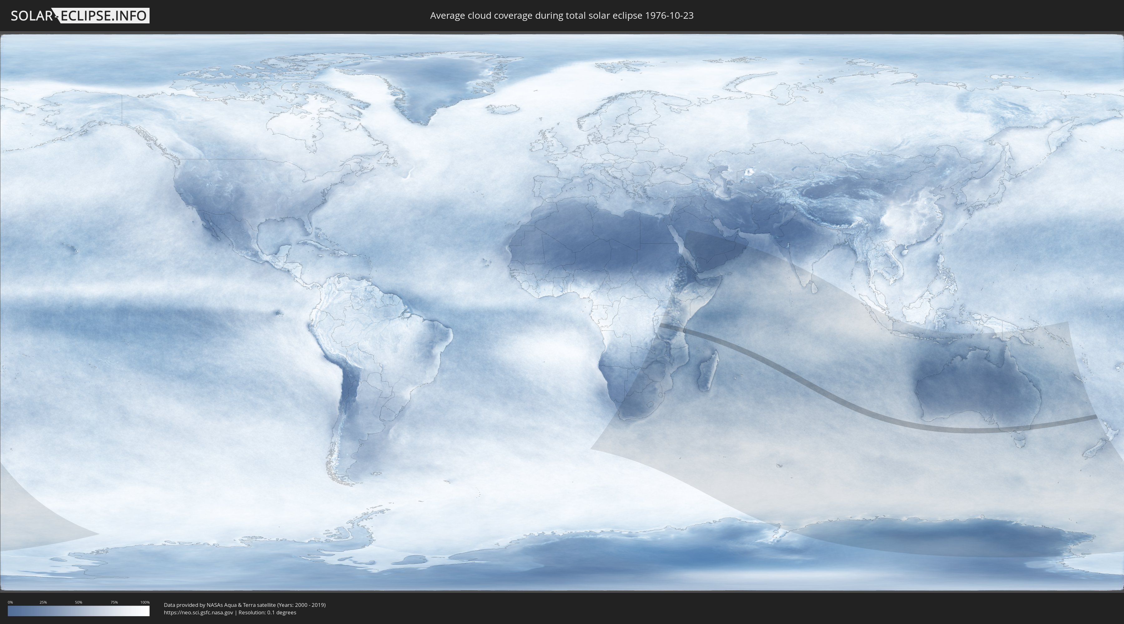
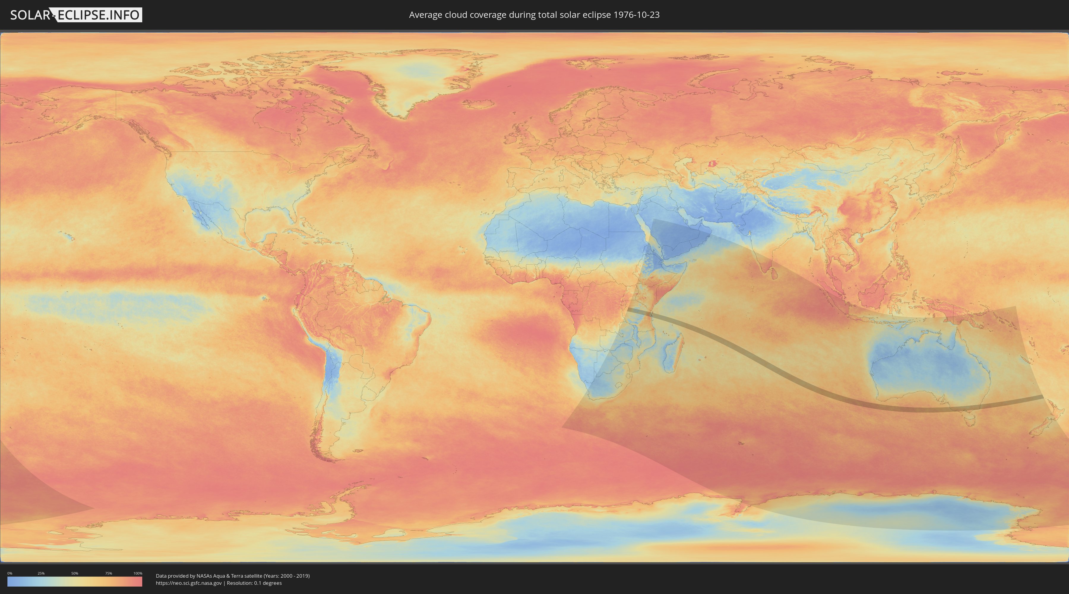
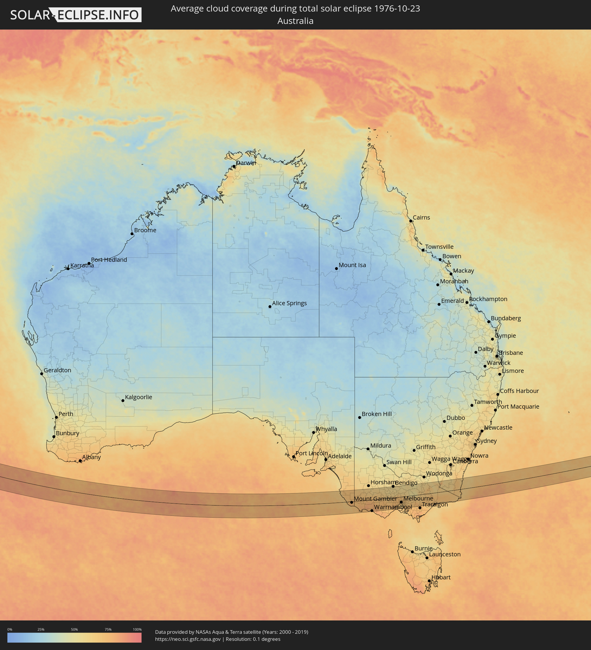
Wie wird das Wetter während der totalen Sonnenfinsternis am 23.10.1976?
Wo ist der beste Ort, um die totale Sonnenfinsternis vom 23.10.1976 zu beobachten?
Die folgenden Karten zeigen die durchschnittliche Bewölkung für den Tag, an dem die totale Sonnenfinsternis
stattfindet. Mit Hilfe der Karten lässt sich der Ort entlang des Finsternispfades eingrenzen,
der die besten Aussichen auf einen klaren wolkenfreien Himmel bietet.
Trotzdem muss man immer lokale Gegenenheiten beachten und sollte sich genau über das Wetter an seinem
gewählten Beobachtungsort informieren.
Die Daten stammen von den beiden NASA-Satelliten
AQUA und TERRA
und wurden über einen Zeitraum von 19 Jahren (2000 - 2019) gemittelt.
Detaillierte Länderkarten
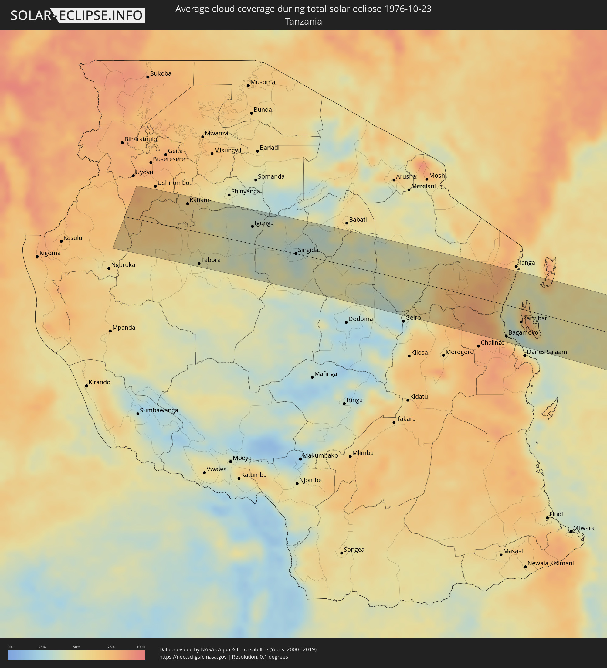 Tansania
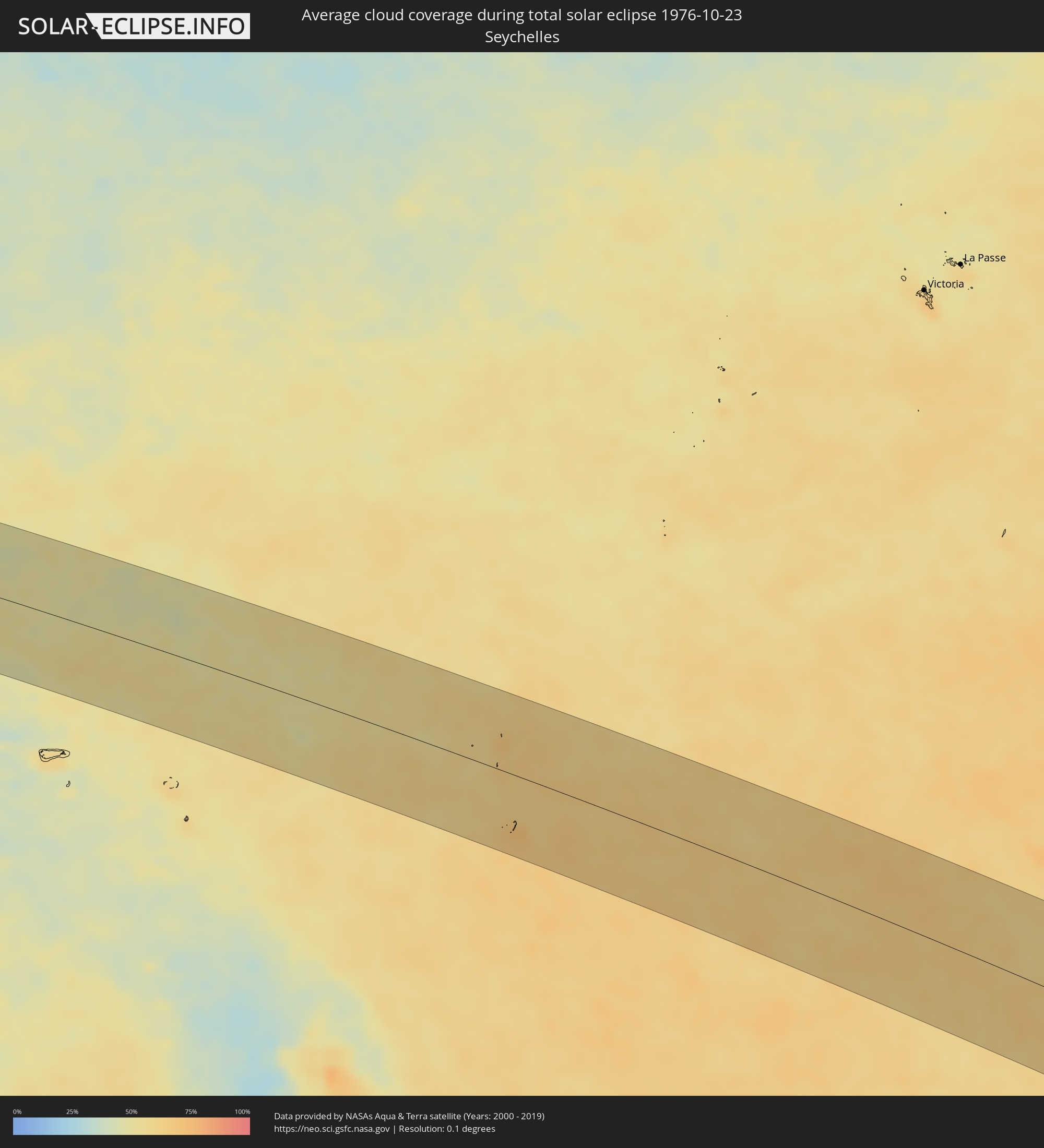 Seychellen
 Australien
Orte im Finsternispfad
Die nachfolgene Tabelle zeigt Städte und Orte mit mehr als 5.000 Einwohnern, die sich im Finsternispfad befinden. Städte mit mehr als 100.000 Einwohnern sind dick gekennzeichnet. Mit einem Klick auf den Ort öffnet sich eine Detailkarte die die Lage des jeweiligen Ortes zusammen mit dem Verlauf der zentralen Finsternis präsentiert.
| Ort | Typ | Dauer der Verfinsterung | Ortszeit bei maximaler Verfinsterung | Entfernung zur Zentrallinie | Ø Bewölkung |
|
Masumbwe, Geita
|
total | - | 06:35:16 UTC+03:00 | 68 km | 67% |
|
Kahama, Shinyanga
|
total | - | 06:35:21 UTC+03:00 | 56 km | 58% |
|
Tabora, Tabora
|
total | - | 06:36:10 UTC+03:00 | 68 km | 48% |
|
Bukene, Tabora
|
total | - | 06:35:36 UTC+03:00 | 19 km | 52% |
|
Isaka, Shinyanga
|
total | - | 06:35:22 UTC+03:00 | 56 km | 52% |
|
Nzega, Tabora
|
total | - | 06:35:34 UTC+03:00 | 28 km | 44% |
|
Tinde, Shinyanga
|
total | - | 06:35:20 UTC+03:00 | 64 km | 44% |
|
Igurubi, Tabora
|
total | - | 06:35:22 UTC+03:00 | 63 km | 39% |
|
Igunga, Tabora
|
total | - | 06:35:33 UTC+03:00 | 37 km | 38% |
|
Shelui, Singida
|
total | - | 06:35:36 UTC+03:00 | 35 km | 37% |
|
Ndago, Singida
|
total | - | 06:35:45 UTC+03:00 | 14 km | 35% |
|
Kiomboi, Singida
|
total | - | 06:35:31 UTC+03:00 | 50 km | 41% |
|
Sepuka, Singida
|
total | - | 06:35:51 UTC+03:00 | 2 km | 38% |
|
Igugunu, Singida
|
total | - | 06:35:43 UTC+03:00 | 24 km | 31% |
|
Puma, Singida
|
total | - | 06:36:02 UTC+03:00 | 20 km | 34% |
|
Singida, Singida
|
total | - | 06:35:53 UTC+03:00 | 0 km | 33% |
|
Ikungi, Singida
|
total | - | 06:36:07 UTC+03:00 | 34 km | 36% |
|
Mtinko, Singida
|
total | - | 06:35:41 UTC+03:00 | 31 km | 31% |
|
Ilongero, Singida
|
total | - | 06:35:47 UTC+03:00 | 19 km | 34% |
|
Mungaa, Singida
|
total | - | 06:36:00 UTC+03:00 | 13 km | 39% |
|
Basotu, Manyara
|
total | - | 06:35:33 UTC+03:00 | 57 km | 34% |
|
Nangwa, Manyara
|
total | - | 06:35:36 UTC+03:00 | 55 km | 40% |
|
Endasak, Manyara
|
total | - | 06:35:34 UTC+03:00 | 63 km | 47% |
|
Kondoa, Dodoma
|
total | - | 06:35:55 UTC+03:00 | 17 km | 41% |
|
Kibaya, Manyara
|
total | - | 06:36:13 UTC+03:00 | 6 km | 47% |
|
Chanika, Tanga
|
total | - | 06:36:21 UTC+03:00 | 20 km | 75% |
|
Magomeni, Tanga
|
total | - | 06:36:13 UTC+03:00 | 42 km | 73% |
|
Maramba, Tanga
|
total | - | 06:36:06 UTC+03:00 | 76 km | 79% |
|
Mvomero, Pwani
|
total | - | 06:37:04 UTC+03:00 | 52 km | 72% |
|
Muheza, Tanga
|
total | - | 06:36:12 UTC+03:00 | 68 km | 78% |
|
Bagamoyo, Pwani
|
total | - | 06:37:15 UTC+03:00 | 66 km | 59% |
|
Pangani, Tanga
|
total | - | 06:36:26 UTC+03:00 | 45 km | 50% |
|
Majengo, Tanga
|
total | - | 06:36:12 UTC+03:00 | 75 km | 62% |
|
Zanzibar, Zanzibar Urban/West
|
total | - | 06:37:02 UTC+03:00 | 28 km | 55% |
|
Mkokotoni, Zanzibar North
|
total | - | 06:36:49 UTC+03:00 | 5 km | 71% |
|
Koani, Zanzibar Central/South
|
total | - | 06:37:01 UTC+03:00 | 22 km | 81% |
|
Nungwi, Zanzibar North
|
total | - | 06:36:42 UTC+03:00 | 22 km | 63% |
|
Mahonda, Zanzibar Central/South
|
total | - | 06:37:18 UTC+03:00 | 51 km | 40% |
|
Sokoni, Zanzibar Central/South
|
total | - | 06:37:18 UTC+03:00 | 47 km | 47% |
|
Mtambile, Pemba South
|
total | - | 06:36:27 UTC+03:00 | 70 km | 64% |
|
Mount Gambier, South Australia
|
total | - | 16:07:45 UTC+09:30 | 8 km | 76% |
|
Portland, Victoria
|
total | - | 16:38:00 UTC+10:00 | 71 km | 73% |
|
Hamilton, Victoria
|
total | - | 16:38:47 UTC+10:00 | 8 km | 76% |
|
Warrnambool, Victoria
|
total | - | 16:38:38 UTC+10:00 | 82 km | 70% |
|
Stawell, Victoria
|
total | - | 16:39:51 UTC+10:00 | 63 km | 64% |
|
Ararat, Victoria
|
total | - | 16:39:47 UTC+10:00 | 36 km | 67% |
|
Maryborough, Victoria
|
total | - | 16:40:32 UTC+10:00 | 55 km | 60% |
|
Sebastopol, Victoria
|
total | - | 16:40:12 UTC+10:00 | 5 km | 69% |
|
Ballarat, Victoria
|
total | - | 16:40:13 UTC+10:00 | 3 km | 69% |
|
Castlemaine, Victoria
|
total | - | 16:40:51 UTC+10:00 | 49 km | 61% |
|
Golden Square, Victoria
|
total | - | 16:41:06 UTC+10:00 | 81 km | 57% |
|
Bendigo, Victoria
|
total | - | 16:41:08 UTC+10:00 | 82 km | 57% |
|
Kennington, Victoria
|
total | - | 16:41:07 UTC+10:00 | 79 km | 57% |
|
Hamlyn Heights, Victoria
|
total | - | 16:40:07 UTC+10:00 | 69 km | 75% |
|
Geelong, Victoria
|
total | - | 16:40:07 UTC+10:00 | 72 km | 73% |
|
Leopold, Victoria
|
total | - | 16:40:09 UTC+10:00 | 78 km | 68% |
|
Clifton Springs, Victoria
|
total | - | 16:40:14 UTC+10:00 | 75 km | 69% |
|
Melton South, Victoria
|
total | - | 16:40:36 UTC+10:00 | 26 km | 74% |
|
Melton, Victoria
|
total | - | 16:40:37 UTC+10:00 | 23 km | 74% |
|
Kurunjang, Victoria
|
total | - | 16:40:38 UTC+10:00 | 22 km | 74% |
|
Hoppers Crossing, Victoria
|
total | - | 16:40:33 UTC+10:00 | 46 km | 70% |
|
Sunbury, Victoria
|
total | - | 16:40:48 UTC+10:00 | 13 km | 74% |
|
Truganina, Victoria
|
total | - | 16:40:38 UTC+10:00 | 39 km | 71% |
|
Derrimut, Victoria
|
total | - | 16:40:40 UTC+10:00 | 37 km | 71% |
|
Delahey, Victoria
|
total | - | 16:40:43 UTC+10:00 | 29 km | 72% |
|
Cairnlea, Victoria
|
total | - | 16:40:42 UTC+10:00 | 33 km | 71% |
|
Saint Albans, Victoria
|
total | - | 16:40:43 UTC+10:00 | 31 km | 72% |
|
Keilor, Victoria
|
total | - | 16:40:46 UTC+10:00 | 29 km | 72% |
|
Braybrook, Victoria
|
total | - | 16:40:43 UTC+10:00 | 37 km | 68% |
|
Maidstone, Victoria
|
total | - | 16:40:44 UTC+10:00 | 36 km | 68% |
|
Tullamarine, Victoria
|
total | - | 16:40:48 UTC+10:00 | 28 km | 71% |
|
Airport West, Victoria
|
total | - | 16:40:47 UTC+10:00 | 30 km | 71% |
|
Gladstone Park, Victoria
|
total | - | 16:40:49 UTC+10:00 | 26 km | 71% |
|
Oak Park, Victoria
|
total | - | 16:40:49 UTC+10:00 | 30 km | 71% |
|
Flemington, Victoria
|
total | - | 16:40:46 UTC+10:00 | 38 km | 68% |
|
Parkville, Victoria
|
total | - | 16:40:47 UTC+10:00 | 38 km | 66% |
|
Docklands, Victoria
|
total | - | 16:40:45 UTC+10:00 | 41 km | 66% |
|
Coburg North, Victoria
|
total | - | 16:40:50 UTC+10:00 | 32 km | 70% |
|
Melbourne, Victoria
|
total | - | 16:40:46 UTC+10:00 | 41 km | 66% |
|
Carlton North, Victoria
|
total | - | 16:40:48 UTC+10:00 | 38 km | 66% |
|
South Melbourne, Victoria
|
total | - | 16:40:45 UTC+10:00 | 43 km | 66% |
|
Brunswick East, Victoria
|
total | - | 16:40:48 UTC+10:00 | 37 km | 66% |
|
Fitzroy, Victoria
|
total | - | 16:40:47 UTC+10:00 | 39 km | 66% |
|
Windsor, Victoria
|
total | - | 16:40:45 UTC+10:00 | 46 km | 64% |
|
Clifton Hill, Victoria
|
total | - | 16:40:48 UTC+10:00 | 40 km | 66% |
|
Albert Park, Victoria
|
total | - | 16:40:46 UTC+10:00 | 44 km | 66% |
|
Black Rock, Victoria
|
total | - | 16:40:41 UTC+10:00 | 59 km | 63% |
|
Fairfield, Victoria
|
total | - | 16:40:50 UTC+10:00 | 38 km | 66% |
|
Ormond, Victoria
|
total | - | 16:40:45 UTC+10:00 | 51 km | 64% |
|
Epping, Victoria
|
total | - | 16:40:56 UTC+10:00 | 24 km | 70% |
|
Cheltenham, Victoria
|
total | - | 16:40:42 UTC+10:00 | 59 km | 63% |
|
Kew East, Victoria
|
total | - | 16:40:50 UTC+10:00 | 40 km | 68% |
|
Heidelberg Heights, Victoria
|
total | - | 16:40:53 UTC+10:00 | 34 km | 68% |
|
Murrumbeena, Victoria
|
total | - | 16:40:46 UTC+10:00 | 52 km | 67% |
|
Rosanna, Victoria
|
total | - | 16:40:53 UTC+10:00 | 35 km | 68% |
|
Ashburton, Victoria
|
total | - | 16:40:48 UTC+10:00 | 48 km | 67% |
|
Hughesdale, Victoria
|
total | - | 16:40:47 UTC+10:00 | 52 km | 67% |
|
Mordialloc, Victoria
|
total | - | 16:40:42 UTC+10:00 | 63 km | 66% |
|
Canterbury, Victoria
|
total | - | 16:40:50 UTC+10:00 | 43 km | 68% |
|
Oakleigh South, Victoria
|
total | - | 16:40:46 UTC+10:00 | 54 km | 67% |
|
Viewbank, Victoria
|
total | - | 16:40:54 UTC+10:00 | 34 km | 68% |
|
Mernda, Victoria
|
total | - | 16:41:01 UTC+10:00 | 19 km | 71% |
|
Aspendale, Victoria
|
total | - | 16:40:41 UTC+10:00 | 66 km | 66% |
|
Montmorency, Victoria
|
total | - | 16:40:56 UTC+10:00 | 32 km | 68% |
|
Clarinda, Victoria
|
total | - | 16:40:46 UTC+10:00 | 56 km | 67% |
|
Chelsea, Victoria
|
total | - | 16:40:41 UTC+10:00 | 69 km | 67% |
|
Aspendale Gardens, Victoria
|
total | - | 16:40:42 UTC+10:00 | 66 km | 66% |
|
Box Hill South, Victoria
|
total | - | 16:40:51 UTC+10:00 | 45 km | 68% |
|
Bonbeach, Victoria
|
total | - | 16:40:40 UTC+10:00 | 70 km | 67% |
|
Frankston, Victoria
|
total | - | 16:40:36 UTC+10:00 | 79 km | 67% |
|
Box Hill, Victoria
|
total | - | 16:40:52 UTC+10:00 | 43 km | 68% |
|
Patterson Lakes, Victoria
|
total | - | 16:40:41 UTC+10:00 | 71 km | 67% |
|
Doncaster East, Victoria
|
total | - | 16:40:54 UTC+10:00 | 40 km | 68% |
|
Eltham North, Victoria
|
total | - | 16:40:58 UTC+10:00 | 30 km | 68% |
|
Blackburn North, Victoria
|
total | - | 16:40:53 UTC+10:00 | 42 km | 68% |
|
Noble Park North, Victoria
|
total | - | 16:40:48 UTC+10:00 | 58 km | 70% |
|
Skye, Victoria
|
total | - | 16:40:42 UTC+10:00 | 76 km | 70% |
|
Scoresby, Victoria
|
total | - | 16:40:52 UTC+10:00 | 53 km | 70% |
|
Rowville, Victoria
|
total | - | 16:40:51 UTC+10:00 | 57 km | 70% |
|
Doveton, Victoria
|
total | - | 16:40:48 UTC+10:00 | 64 km | 72% |
|
Knoxfield, Victoria
|
total | - | 16:40:53 UTC+10:00 | 52 km | 70% |
|
Lynbrook, Victoria
|
total | - | 16:40:46 UTC+10:00 | 71 km | 71% |
|
Cranbourne West, Victoria
|
total | - | 16:40:44 UTC+10:00 | 75 km | 71% |
|
Cranbourne East, Victoria
|
total | - | 16:40:44 UTC+10:00 | 78 km | 71% |
|
Bayswater North, Victoria
|
total | - | 16:40:58 UTC+10:00 | 46 km | 69% |
|
Lysterfield, Victoria
|
total | - | 16:40:53 UTC+10:00 | 58 km | 70% |
|
Croydon North, Victoria
|
total | - | 16:41:00 UTC+10:00 | 41 km | 69% |
|
Chirnside Park, Victoria
|
total | - | 16:41:03 UTC+10:00 | 36 km | 70% |
|
Narre Warren North, Victoria
|
total | - | 16:40:51 UTC+10:00 | 63 km | 72% |
|
Upwey, Victoria
|
total | - | 16:40:56 UTC+10:00 | 54 km | 70% |
|
Lilydale, Victoria
|
total | - | 16:41:04 UTC+10:00 | 38 km | 69% |
|
Montrose, Victoria
|
total | - | 16:41:01 UTC+10:00 | 45 km | 69% |
|
Berwick, Victoria
|
total | - | 16:40:50 UTC+10:00 | 69 km | 73% |
|
Mount Evelyn, Victoria
|
total | - | 16:41:03 UTC+10:00 | 42 km | 69% |
|
Emerald, Victoria
|
total | - | 16:40:59 UTC+10:00 | 59 km | 71% |
|
Pakenham South, Victoria
|
total | - | 16:40:52 UTC+10:00 | 82 km | 74% |
|
Healesville, Victoria
|
total | - | 16:41:15 UTC+10:00 | 29 km | 66% |
|
Bairnsdale, Victoria
|
total | - | 16:42:20 UTC+10:00 | 70 km | 70% |
|
Lakes Entrance, Victoria
|
total | - | 16:42:29 UTC+10:00 | 81 km | 66% |
|
Merimbula, New South Wales
|
total | - | 16:44:15 UTC+10:00 | 5 km | 66% |