Annular solar eclipse of 01/15/2010
Wo kann man die Sonnenfinsternis vom 01/15/2010 sehen?
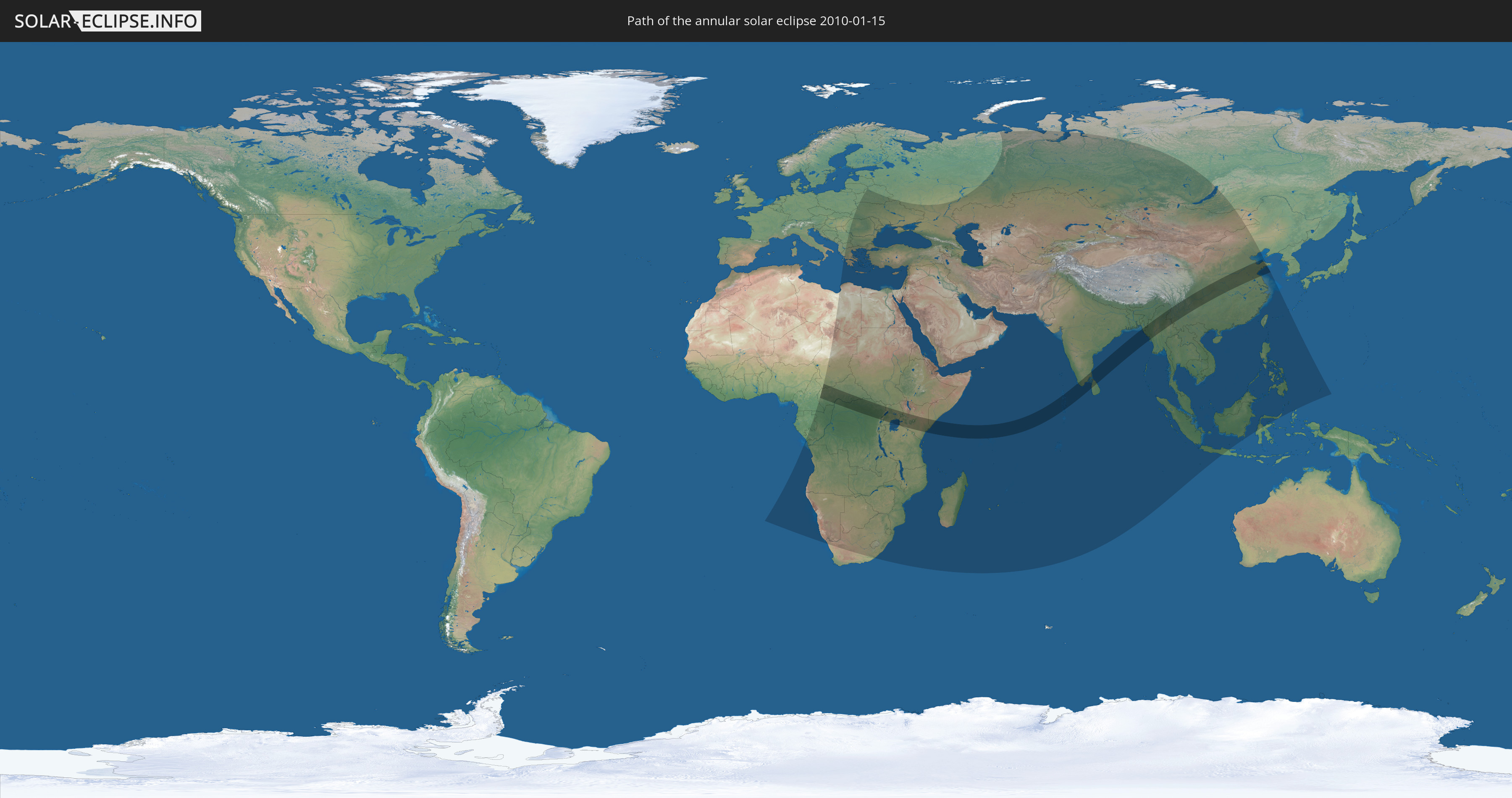
Die Sonnenfinsternis am 01/15/2010 kann man in 97 Ländern als partielle Sonnenfinsternis beobachten.
Der Finsternispfad verläuft durch 14 Länder. Nur in diesen Ländern ist sie als annular Sonnenfinsternis zu sehen.
In den folgenden Ländern ist die Sonnenfinsternis annular zu sehen
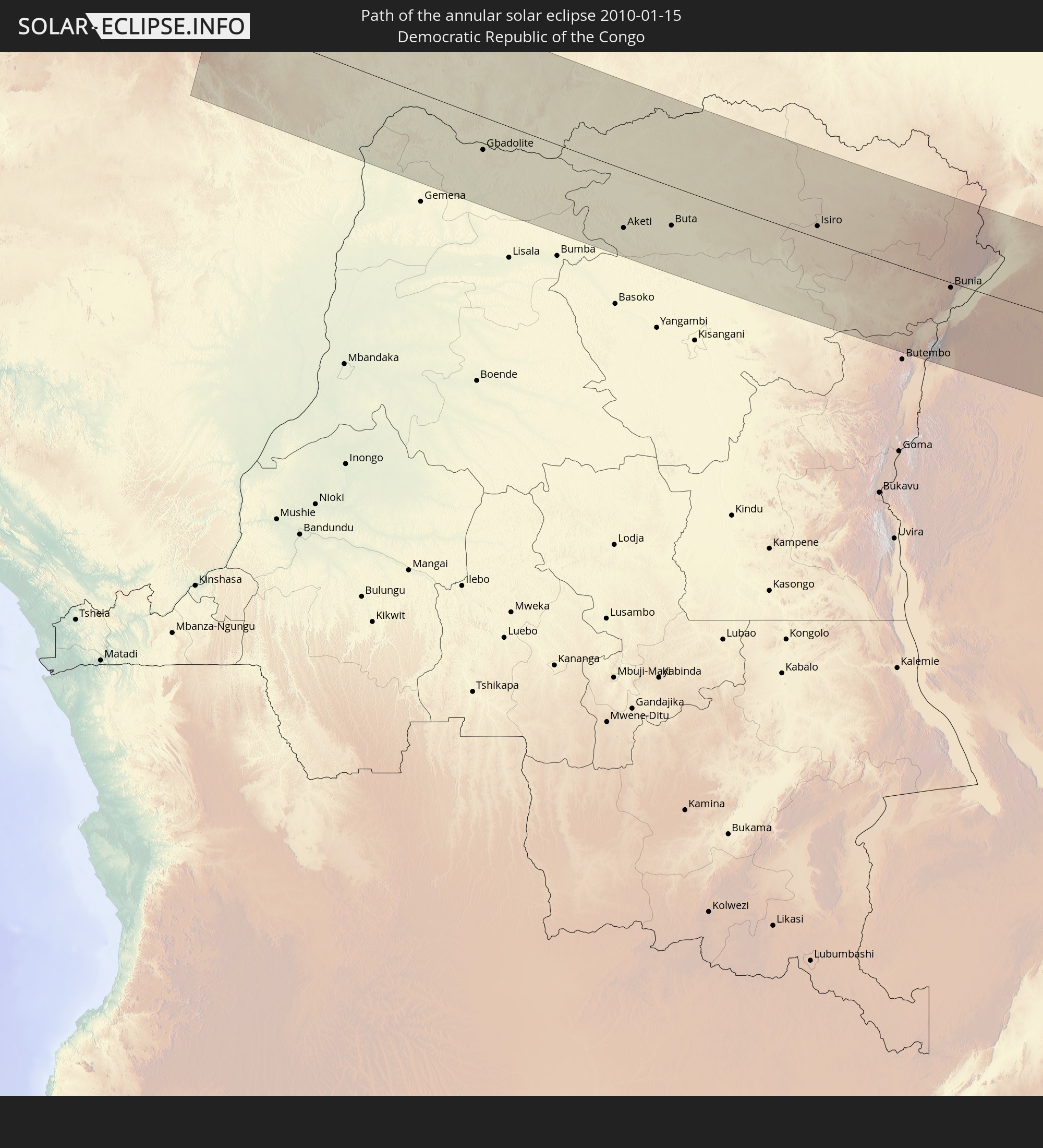 Democratic Republic of the Congo
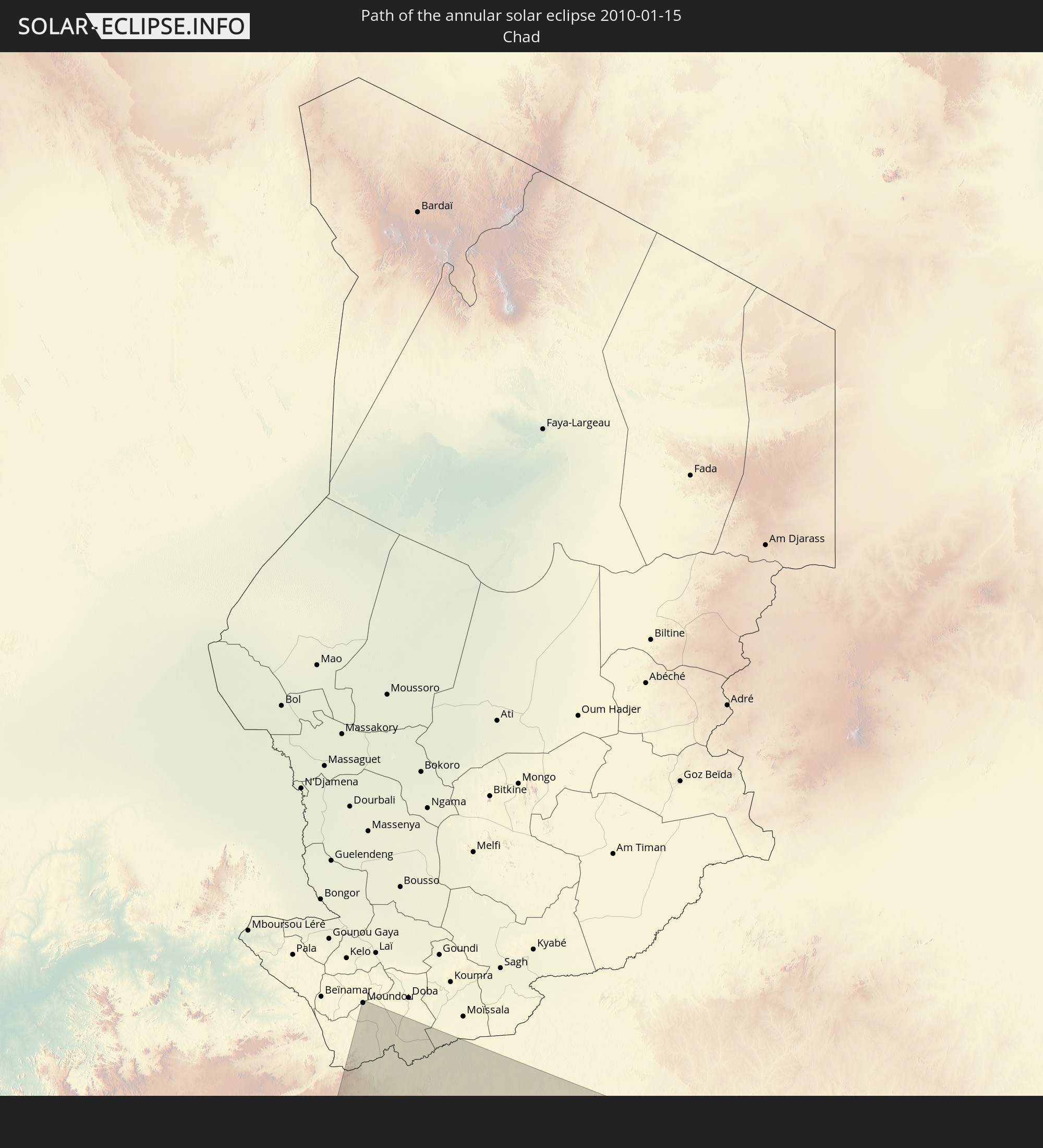 Chad
Chad
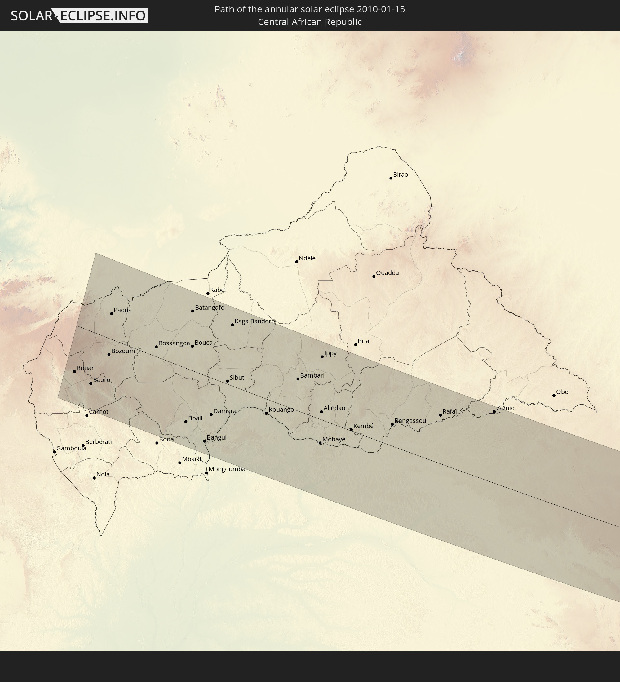 Central African Republic
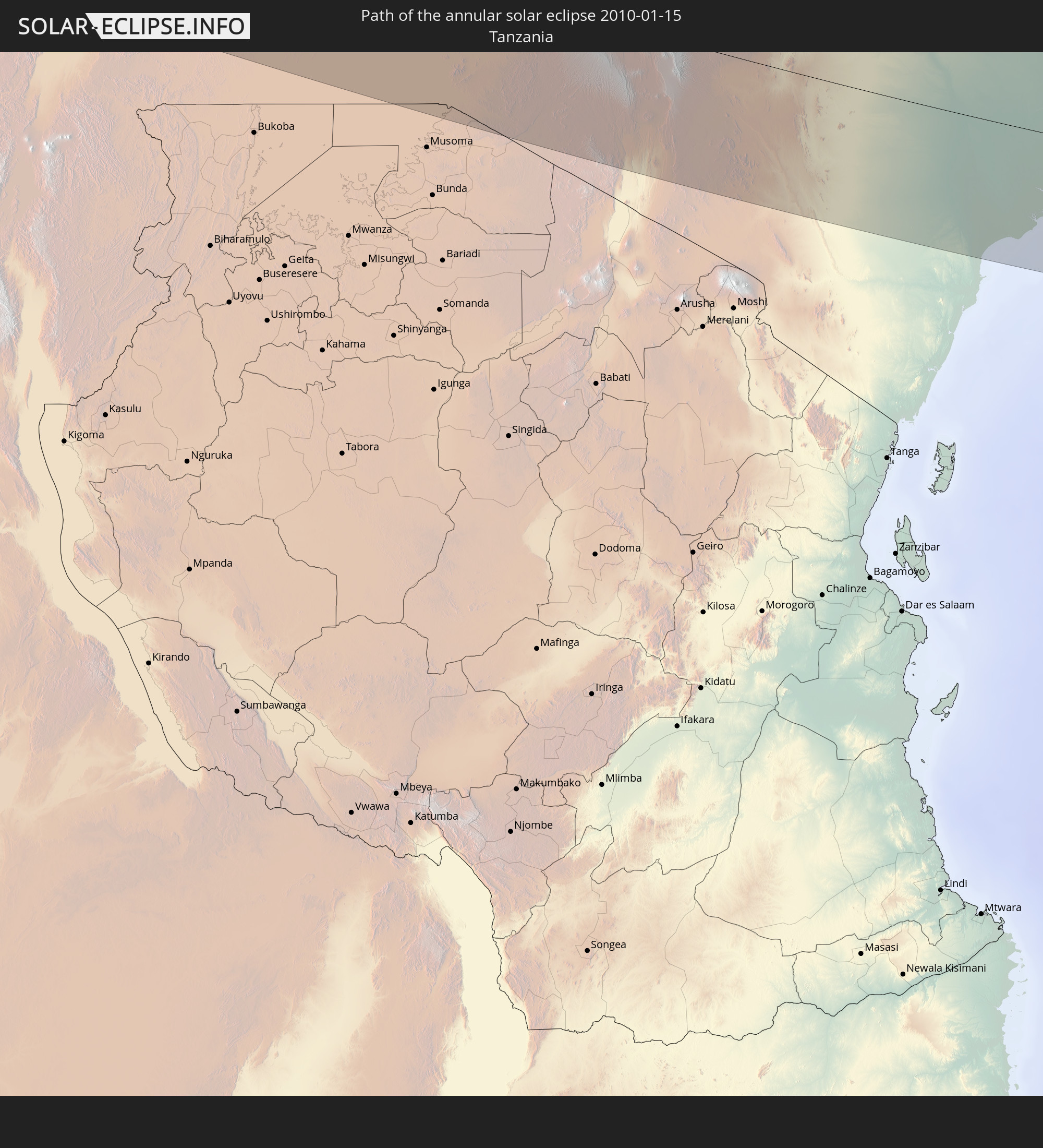 Tanzania
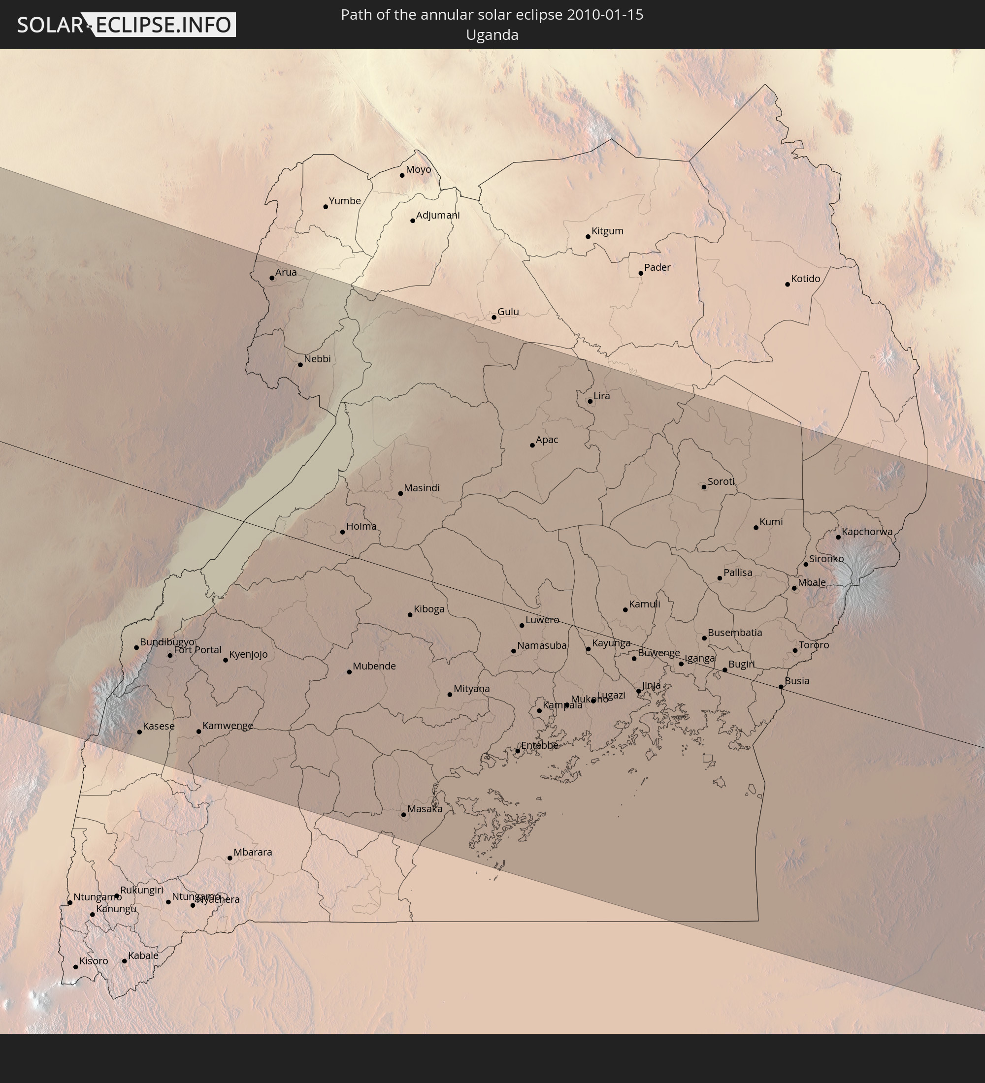 Uganda
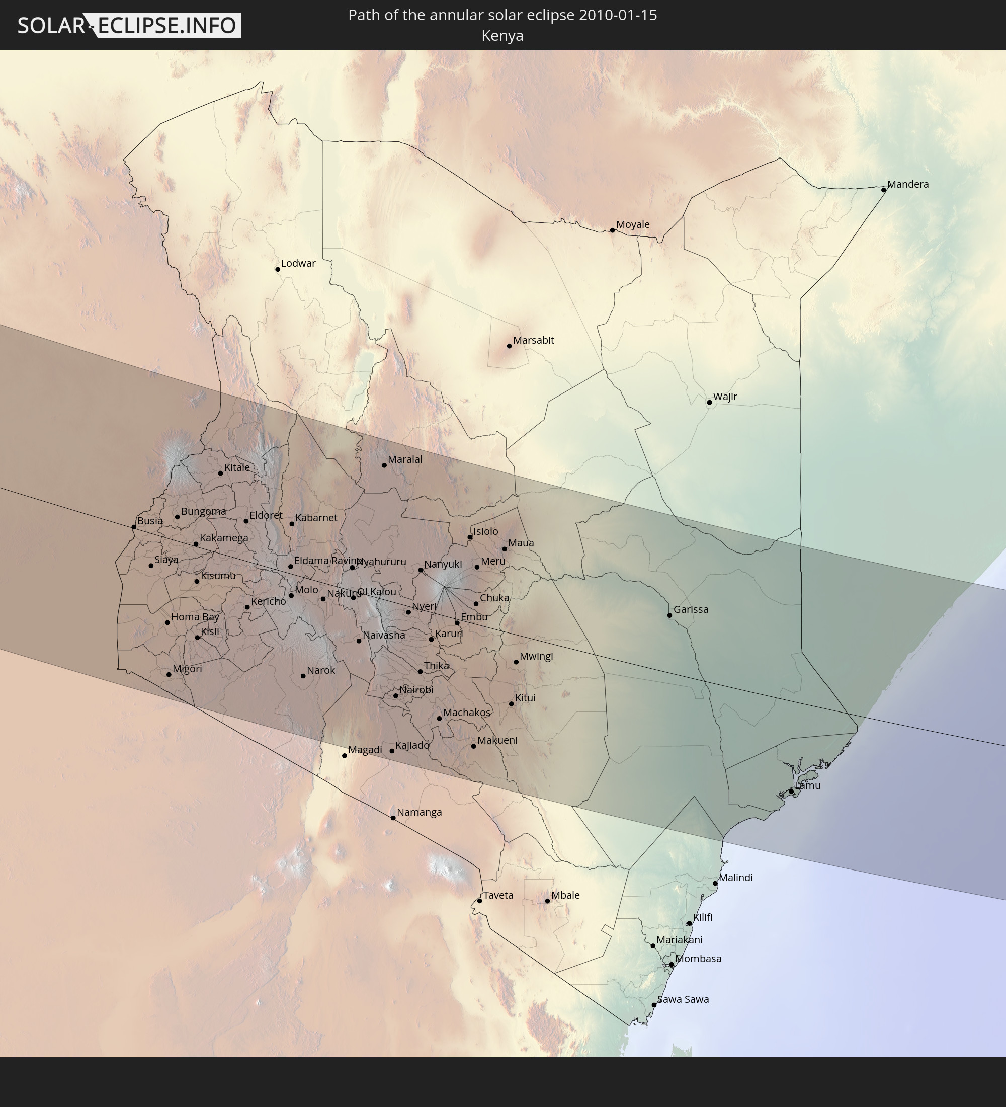 Kenya
Kenya
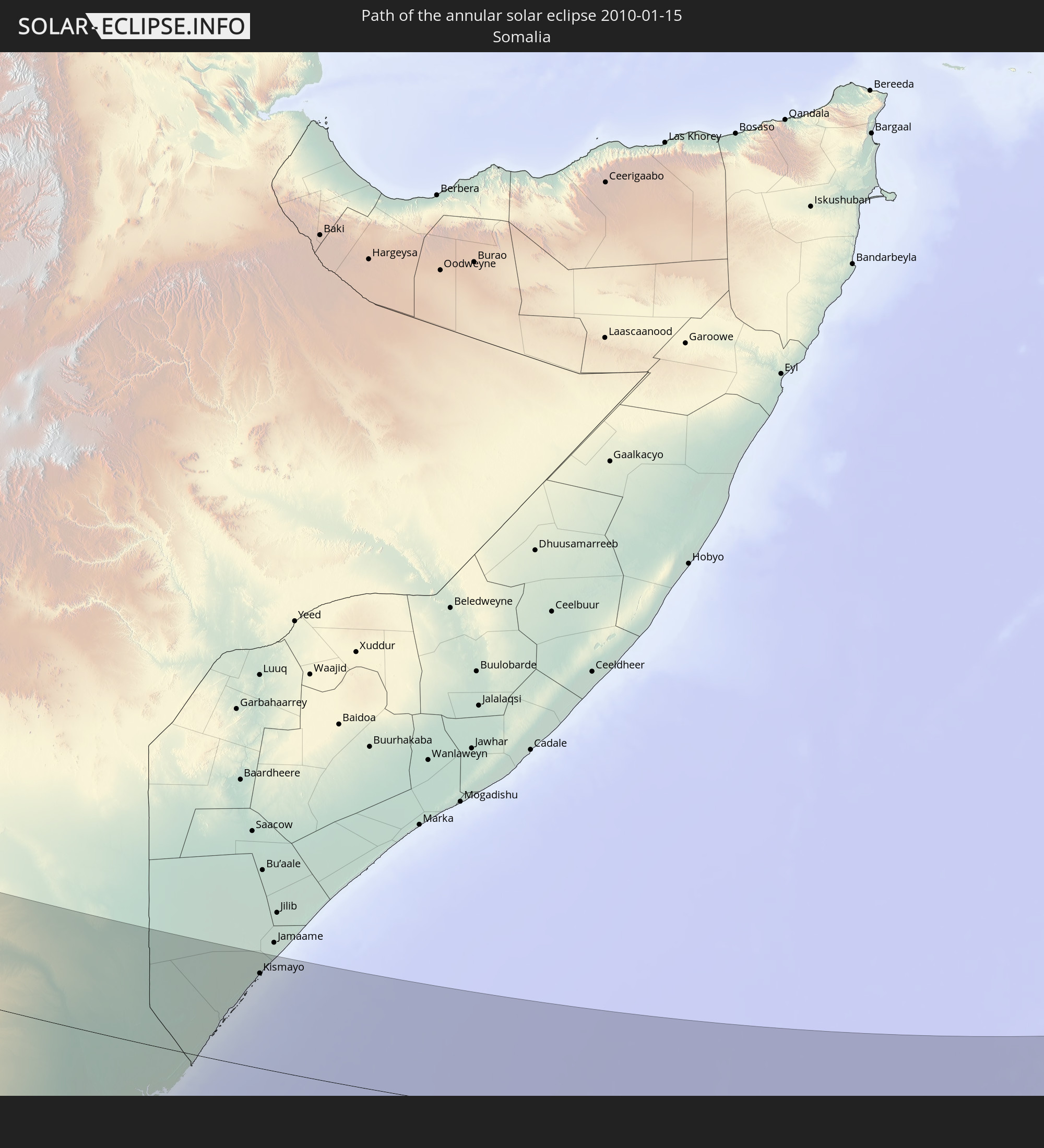 Somalia
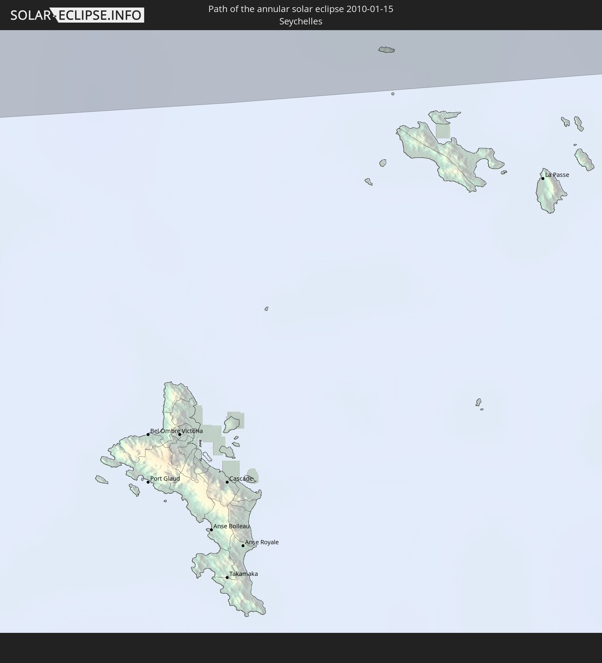 Seychelles
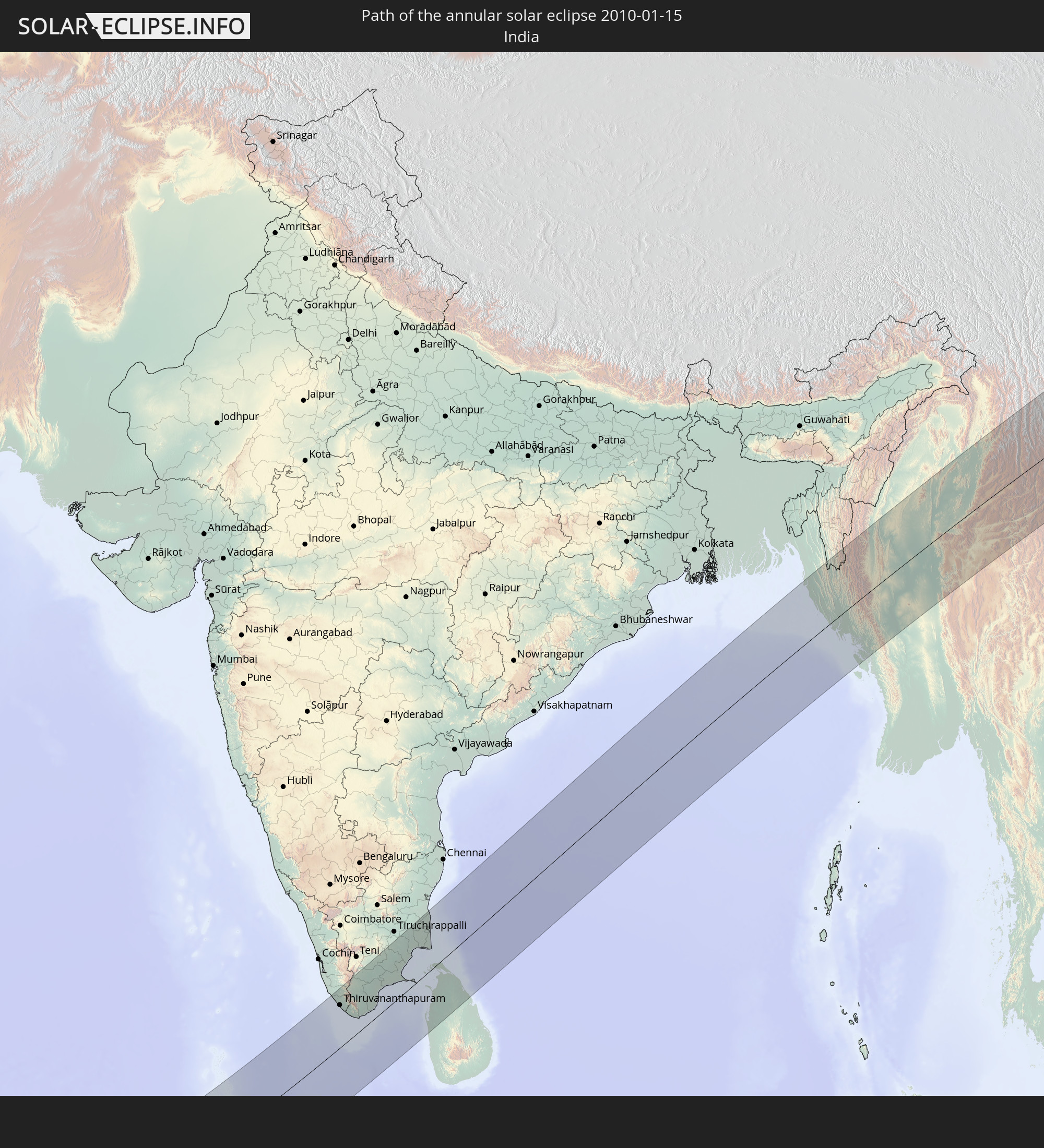 India
India
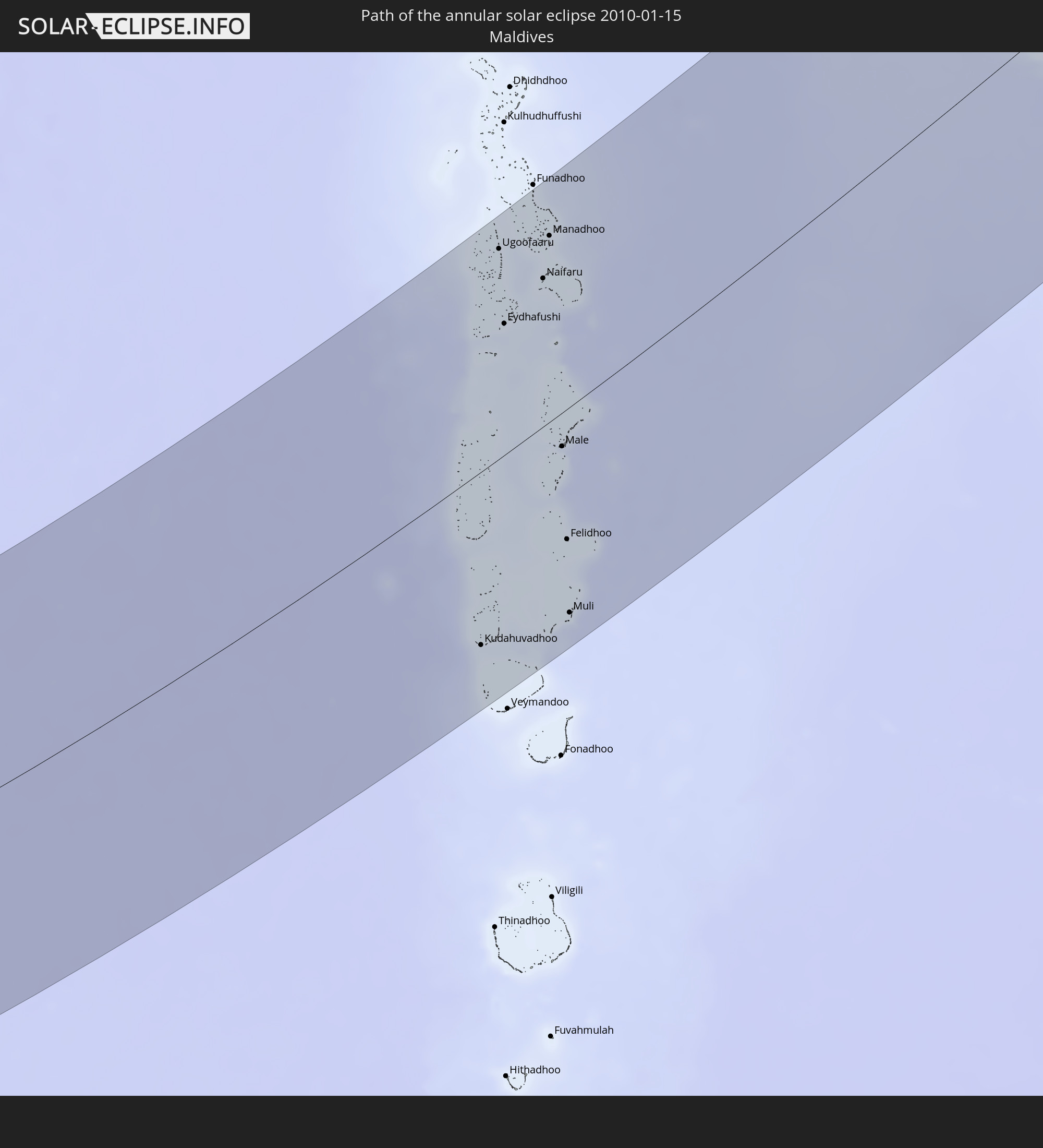 Maldives
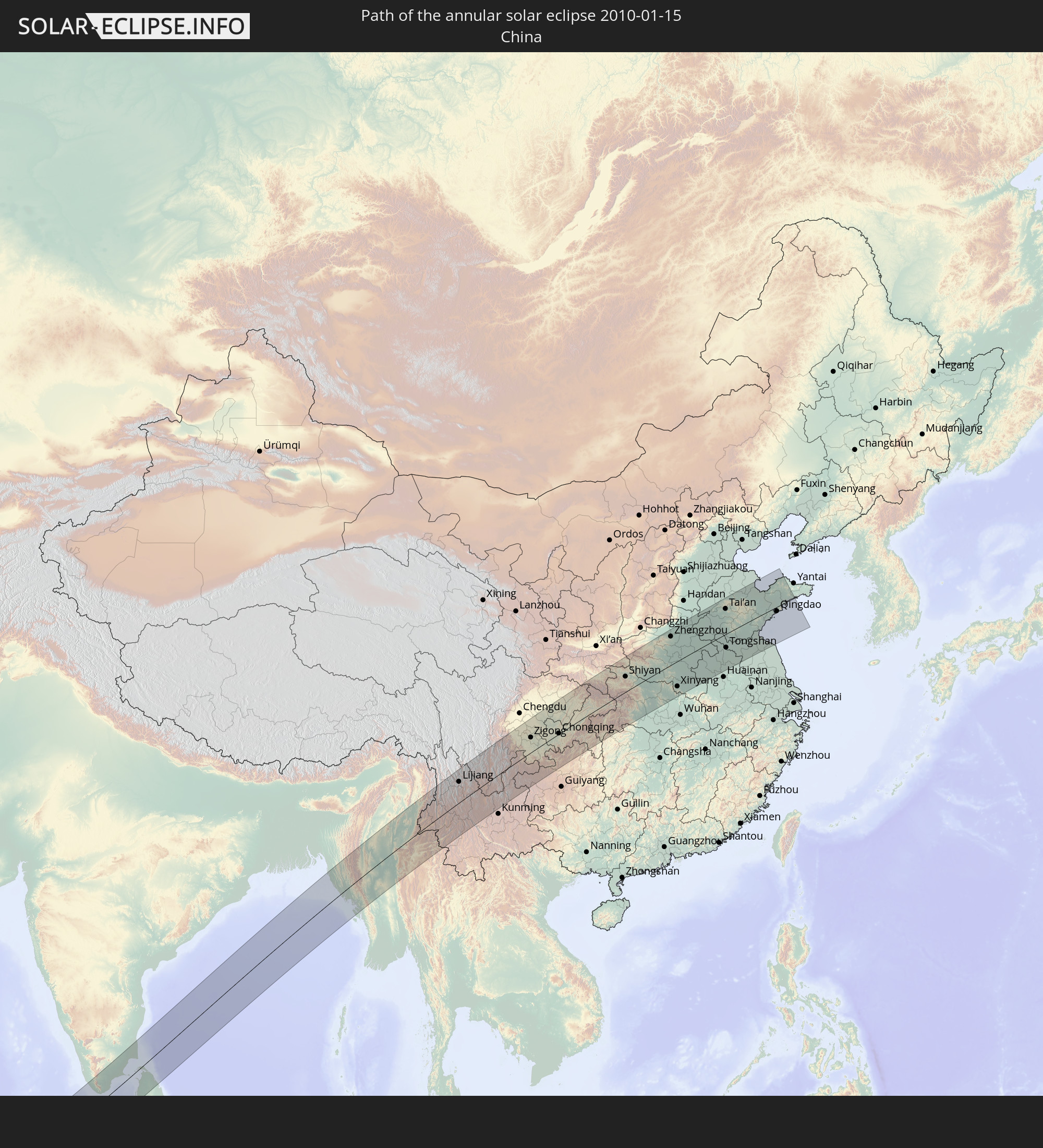 China
China
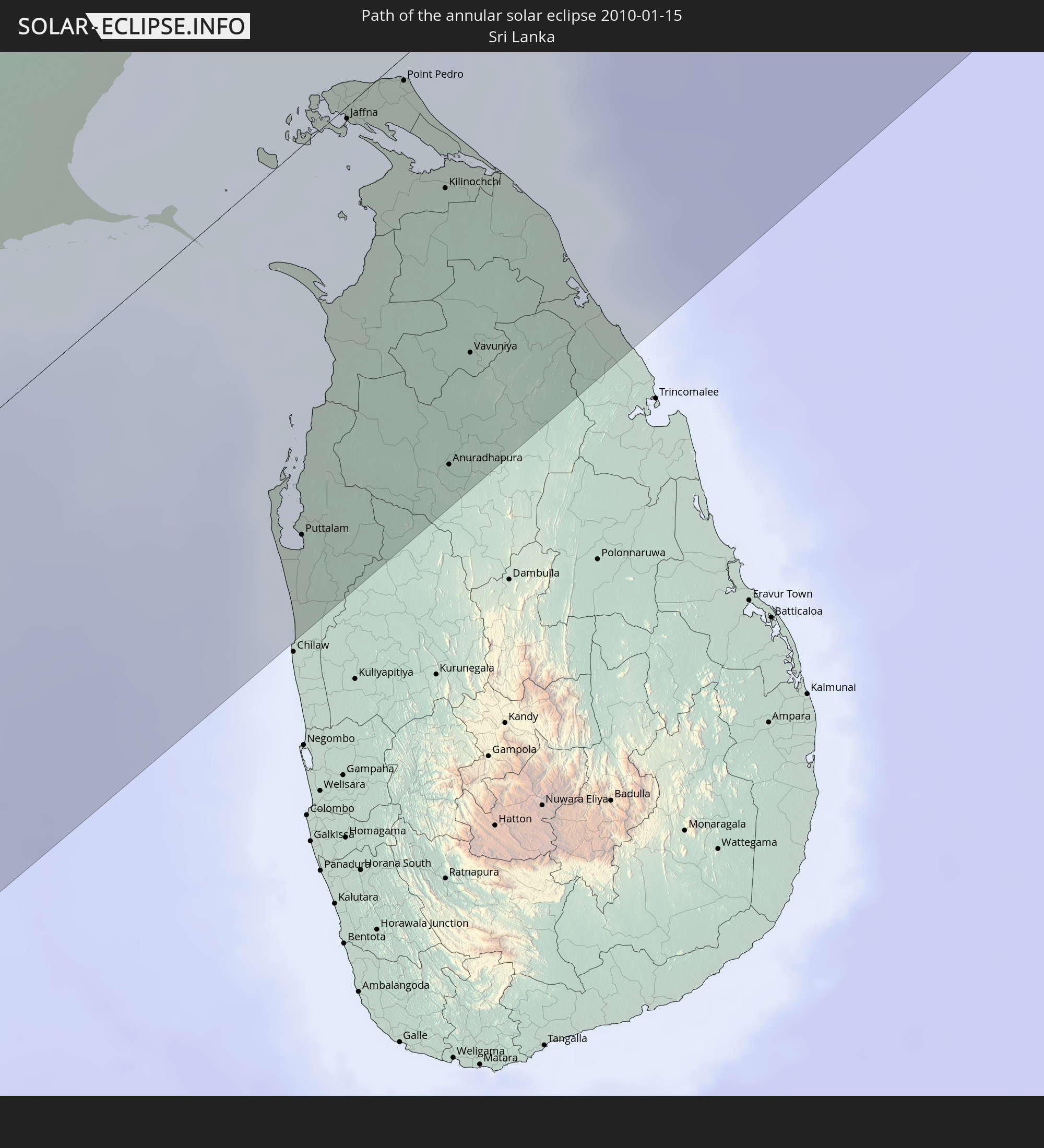 Sri Lanka
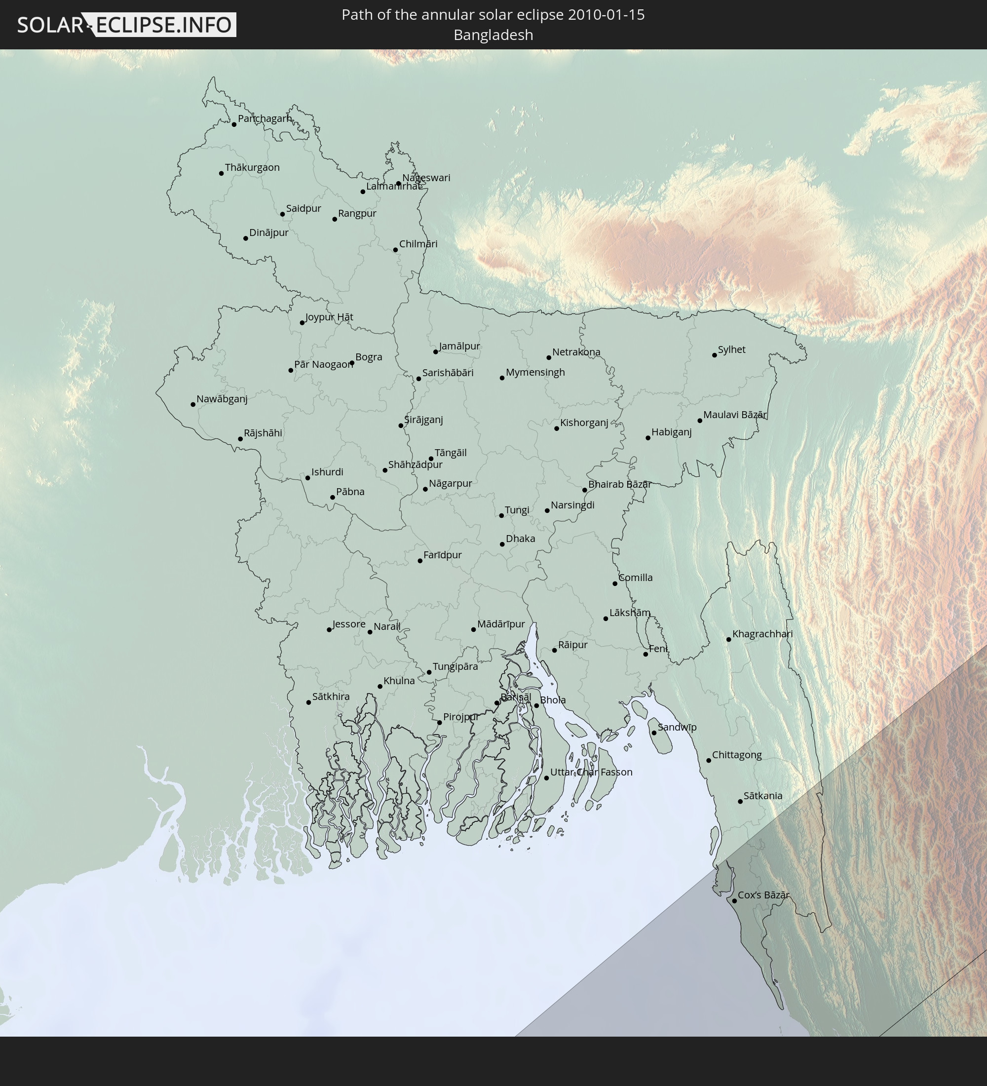 Bangladesh
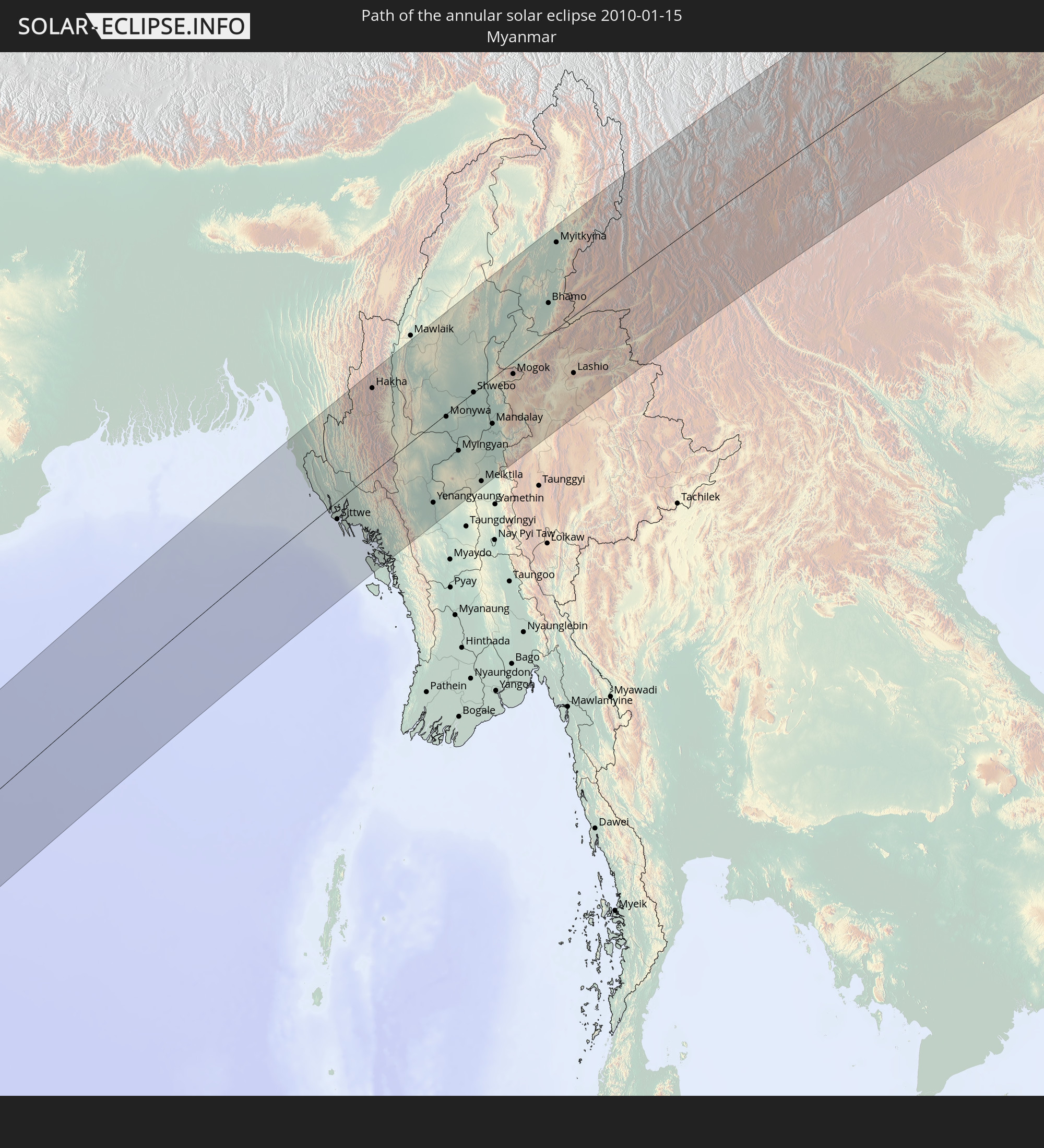 Myanmar
In den folgenden Ländern ist die Sonnenfinsternis partiell zu sehen
 Russia
 Cameroon
 Gabon
Gabon
 Libya
Libya
 Republic of the Congo
 Angola
 Namibia
 Democratic Republic of the Congo
 Chad
Chad
 Poland
 Central African Republic
 South Africa
 Serbia
 Greece
 Botswana
 Romania
 Republic of Macedonia
 Sudan
Sudan
 Zambia
 Ukraine
 Bulgaria
 Belarus
 Egypt
Egypt
 Zimbabwe
 Turkey
 Moldova
 Lesotho
 Rwanda
 Burundi
 Tanzania
 Uganda
 Mozambique
 Swaziland
 Cyprus
 Malawi
 Ethiopia
 Kenya
Kenya
 State of Palestine
 Israel
 Saudi Arabia
 Jordan
 Lebanon
 Syria
Syria
 Eritrea
 Iraq
Iraq
 Georgia
 French Southern and Antarctic Lands
 Somalia
 Djibouti
 Yemen
Yemen
 Madagascar
 Comoros
 Armenia
 Iran
Iran
 Azerbaijan
 Mayotte
 Seychelles
 Kazakhstan
 Kuwait
 Bahrain
 Qatar
Qatar
 United Arab Emirates
 Oman
Oman
 Turkmenistan
 Réunion
 Uzbekistan
 Mauritius
 Afghanistan
 Pakistan
 Tajikistan
 India
India
 Kyrgyzstan
 British Indian Ocean Territory
 Maldives
 China
China
 Sri Lanka
 Nepal
Nepal
 Mongolia
 Bangladesh
 Bhutan
 Myanmar
 Indonesia
 Cocos Islands
 Thailand
 Malaysia
 Laos
Laos
 Vietnam
 Cambodia
 Singapore
 Christmas Island
 Macau
Macau
 Hong Kong
 Brunei
 Taiwan
 Philippines
 Japan
Japan
 Palau
Palau
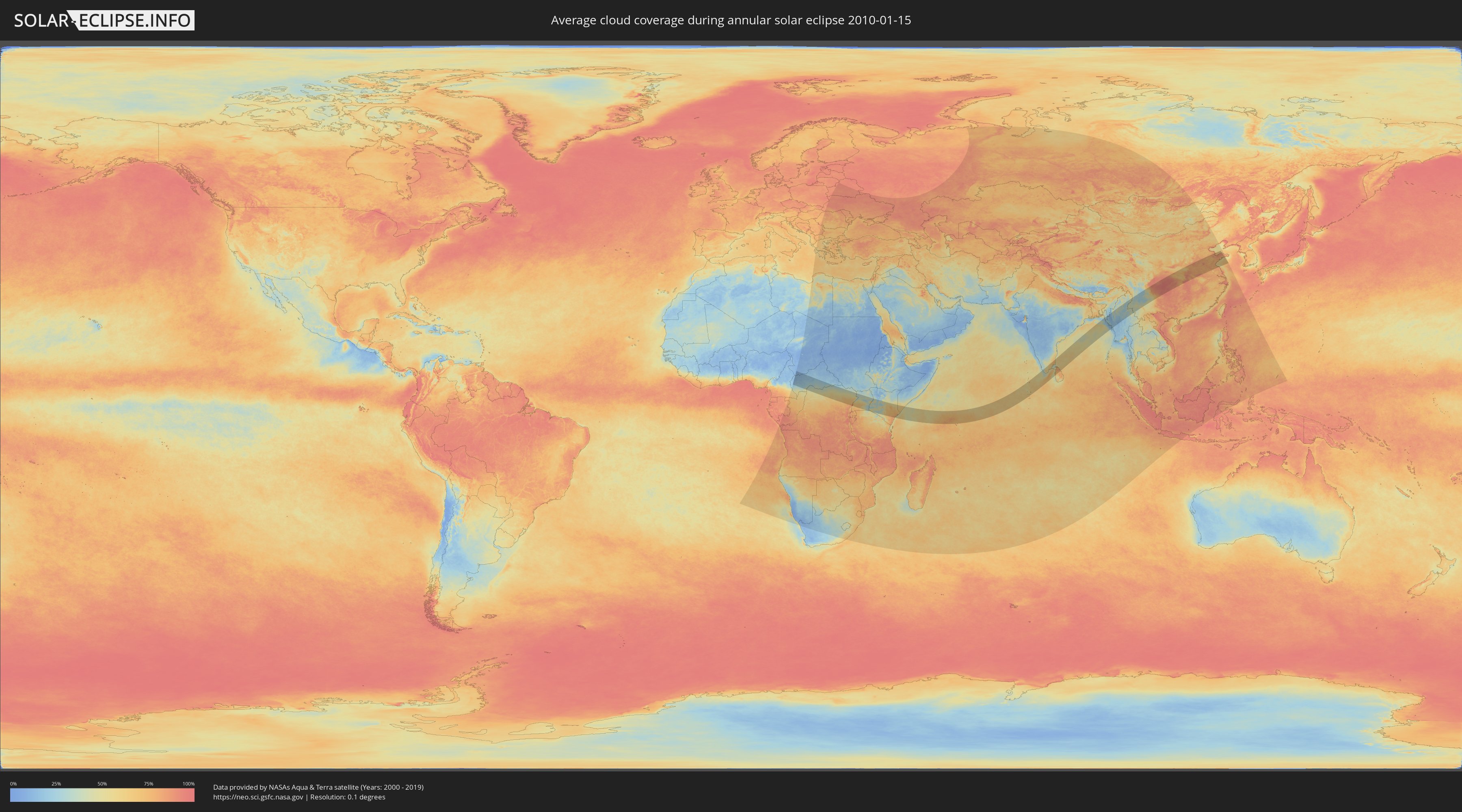
How will be the weather during the annular solar eclipse on 01/15/2010?
Where is the best place to see the annular solar eclipse of 01/15/2010?
The following maps show the average cloud coverage for the day of the annular solar eclipse.
With the help of these maps, it is possible to find the place along the eclipse path, which has the best
chance of a cloudless sky.
Nevertheless, you should consider local circumstances and inform about the weather of your chosen
observation site.
The data is provided by NASAs satellites
AQUA and TERRA.
The cloud maps are averaged over a period of 19 years (2000 - 2019).

Detailed country maps
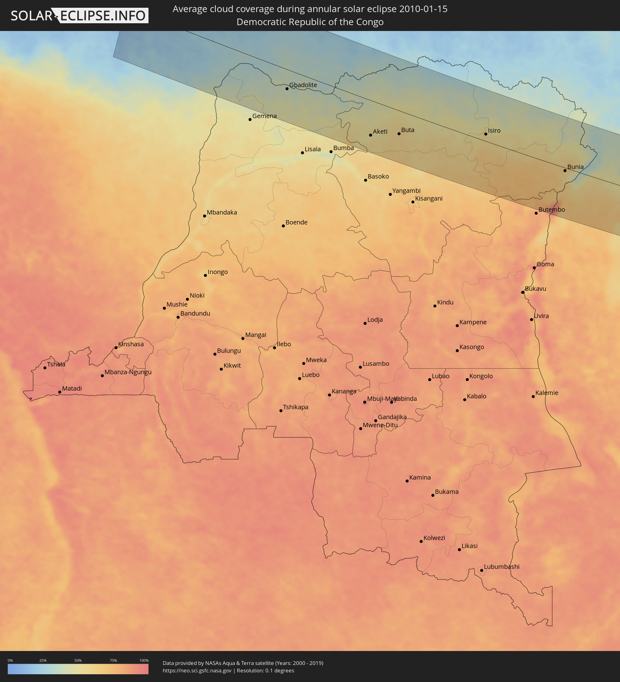 Democratic Republic of the Congo
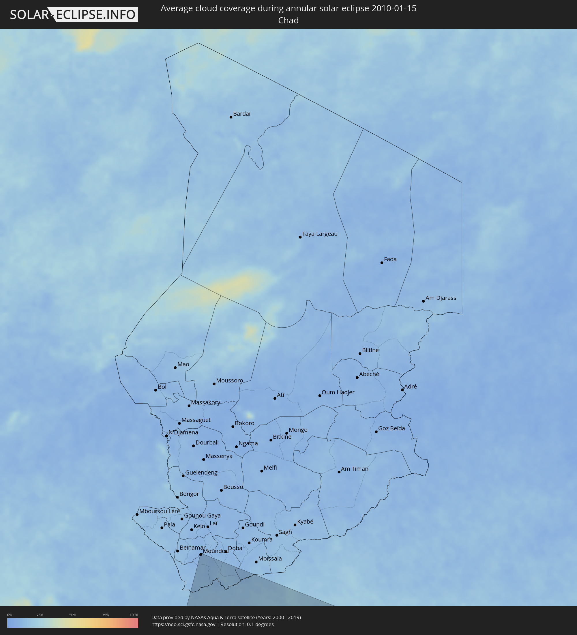 Chad
Chad
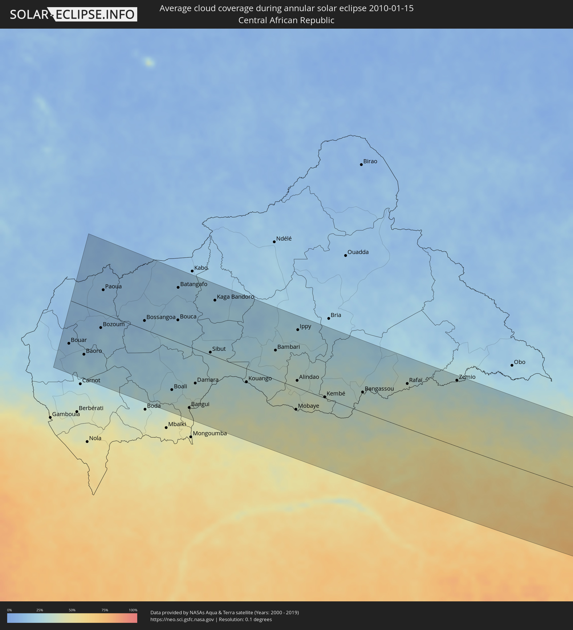 Central African Republic
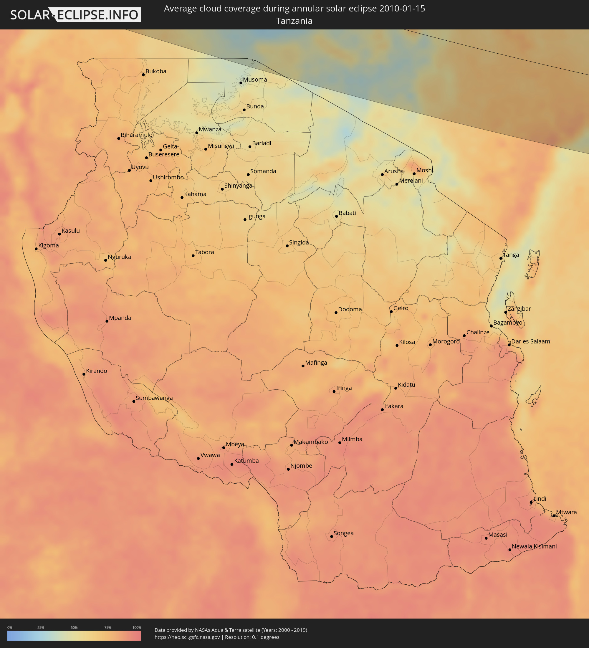 Tanzania
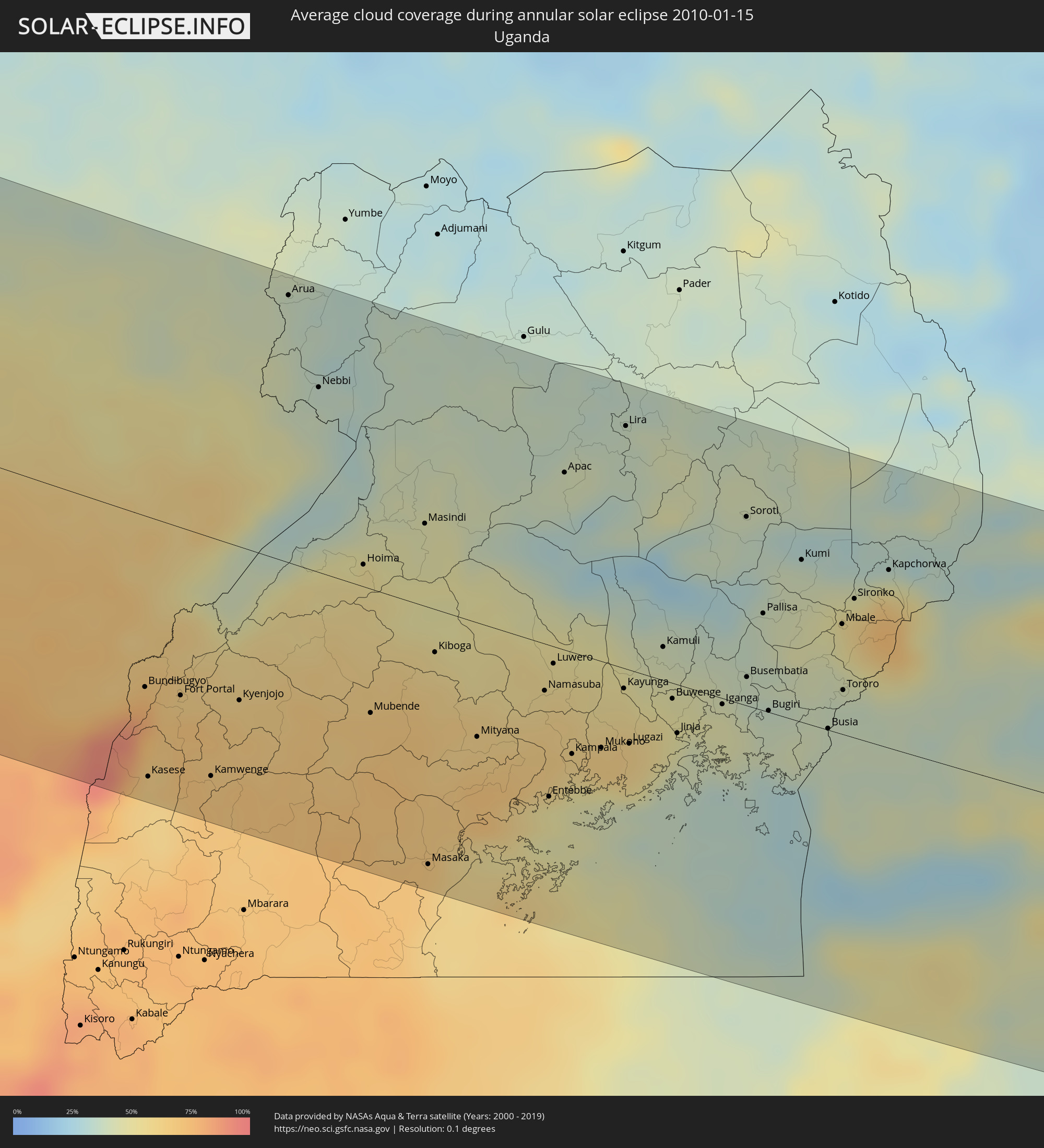 Uganda
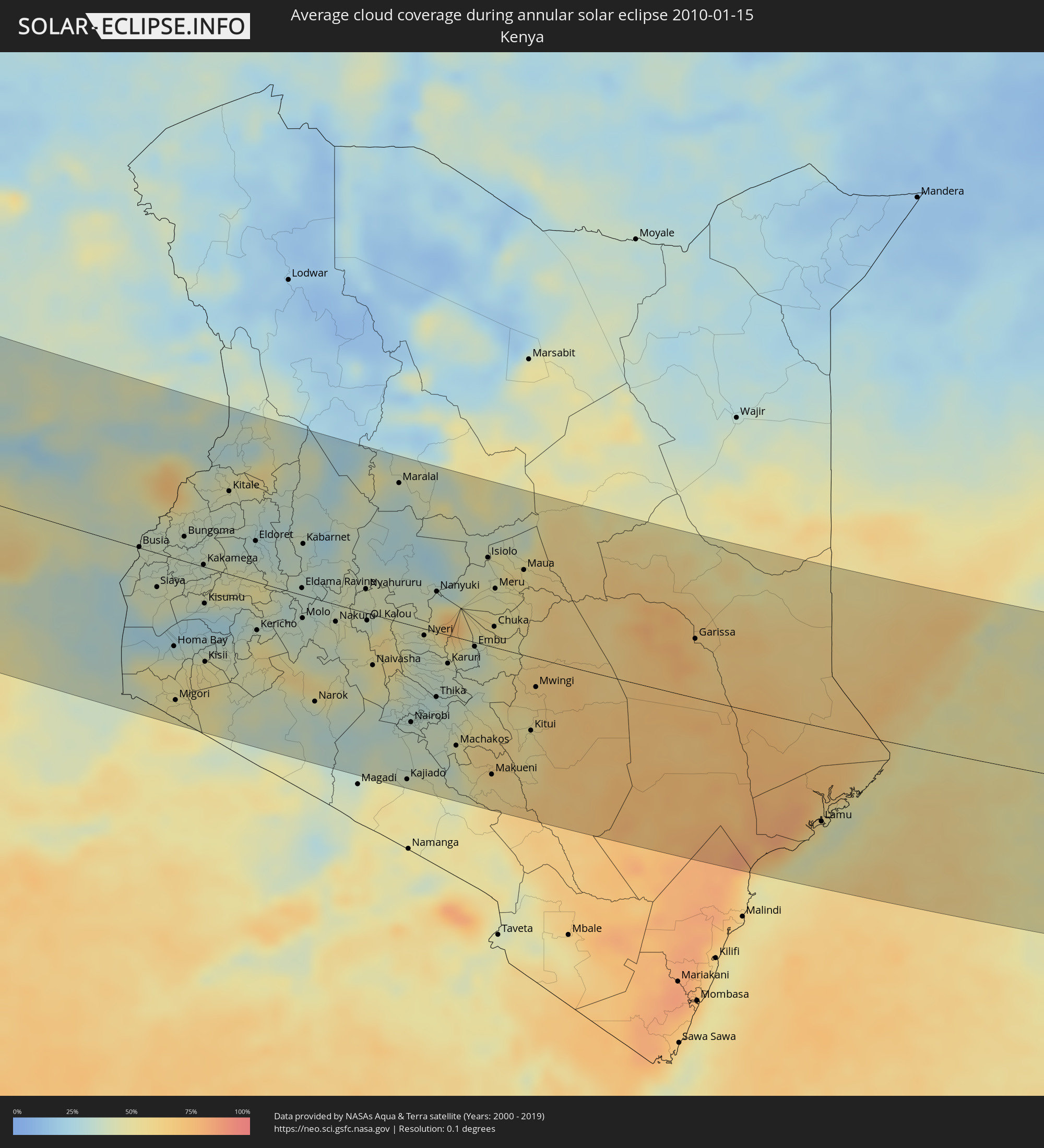 Kenya
Kenya
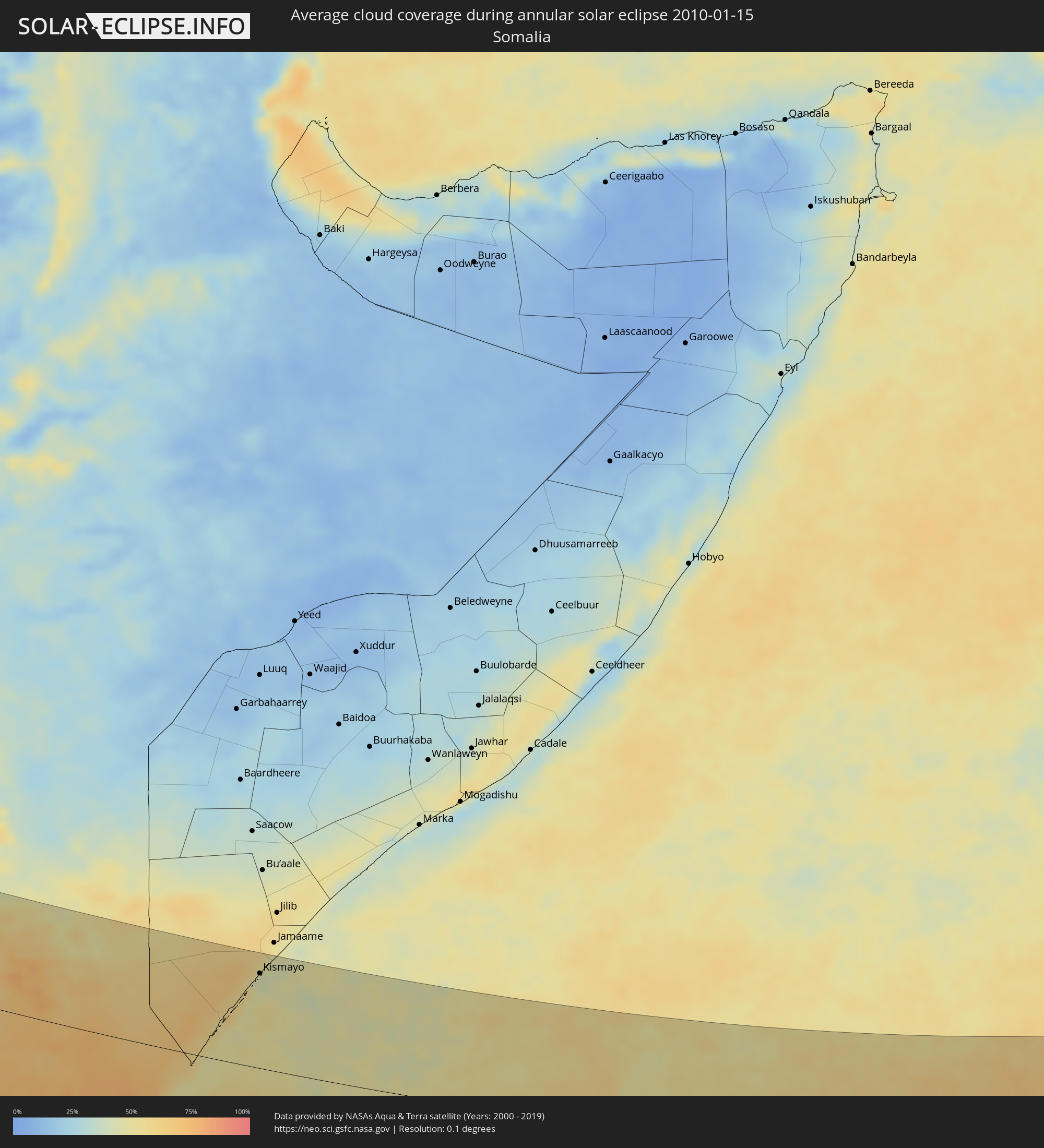 Somalia
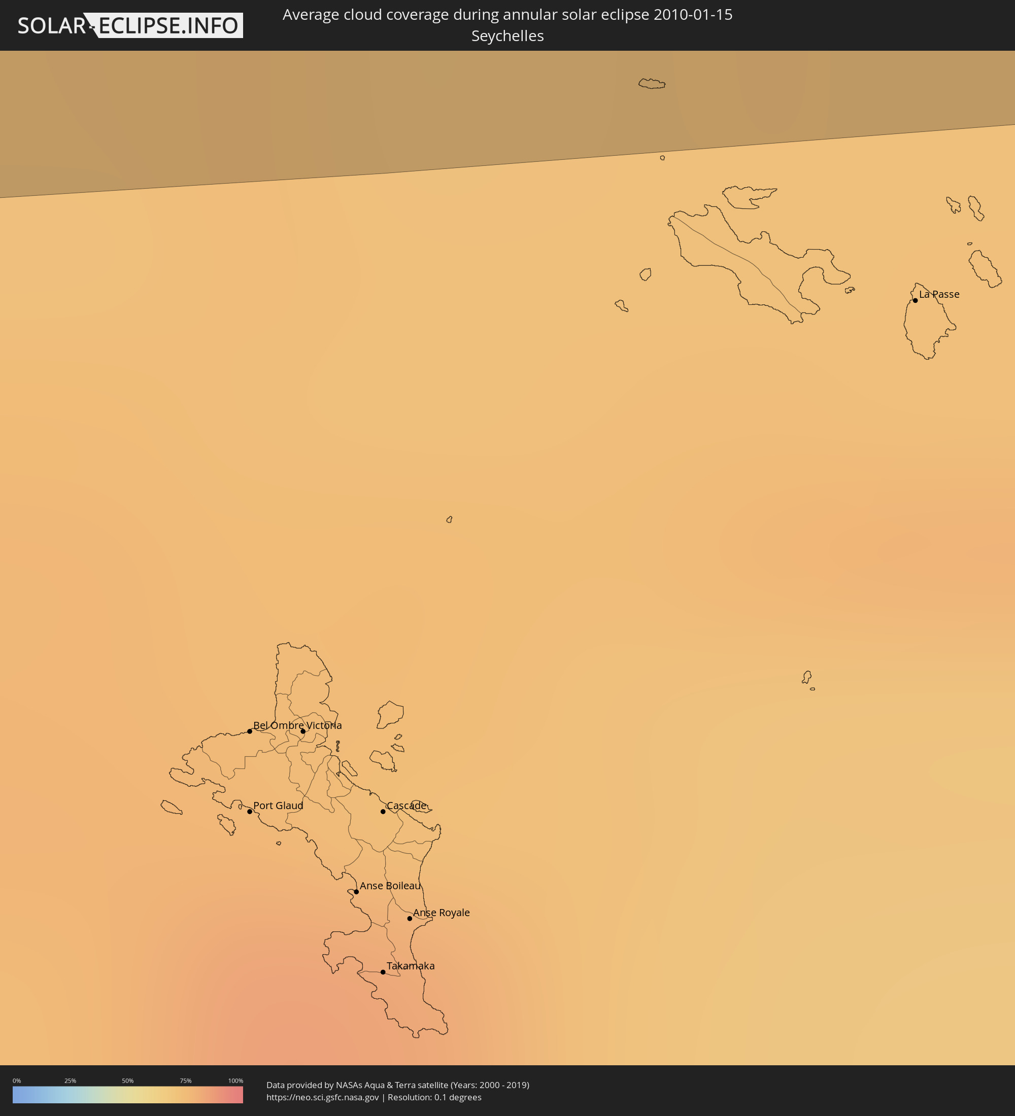 Seychelles
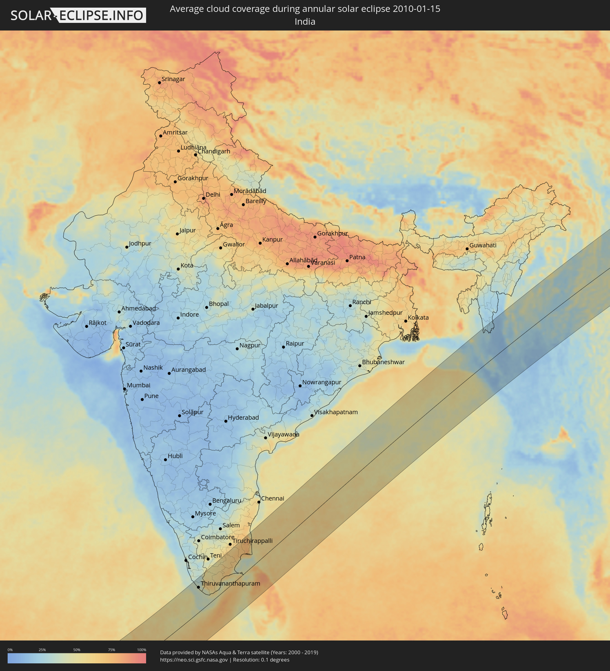 India
India
 Maldives
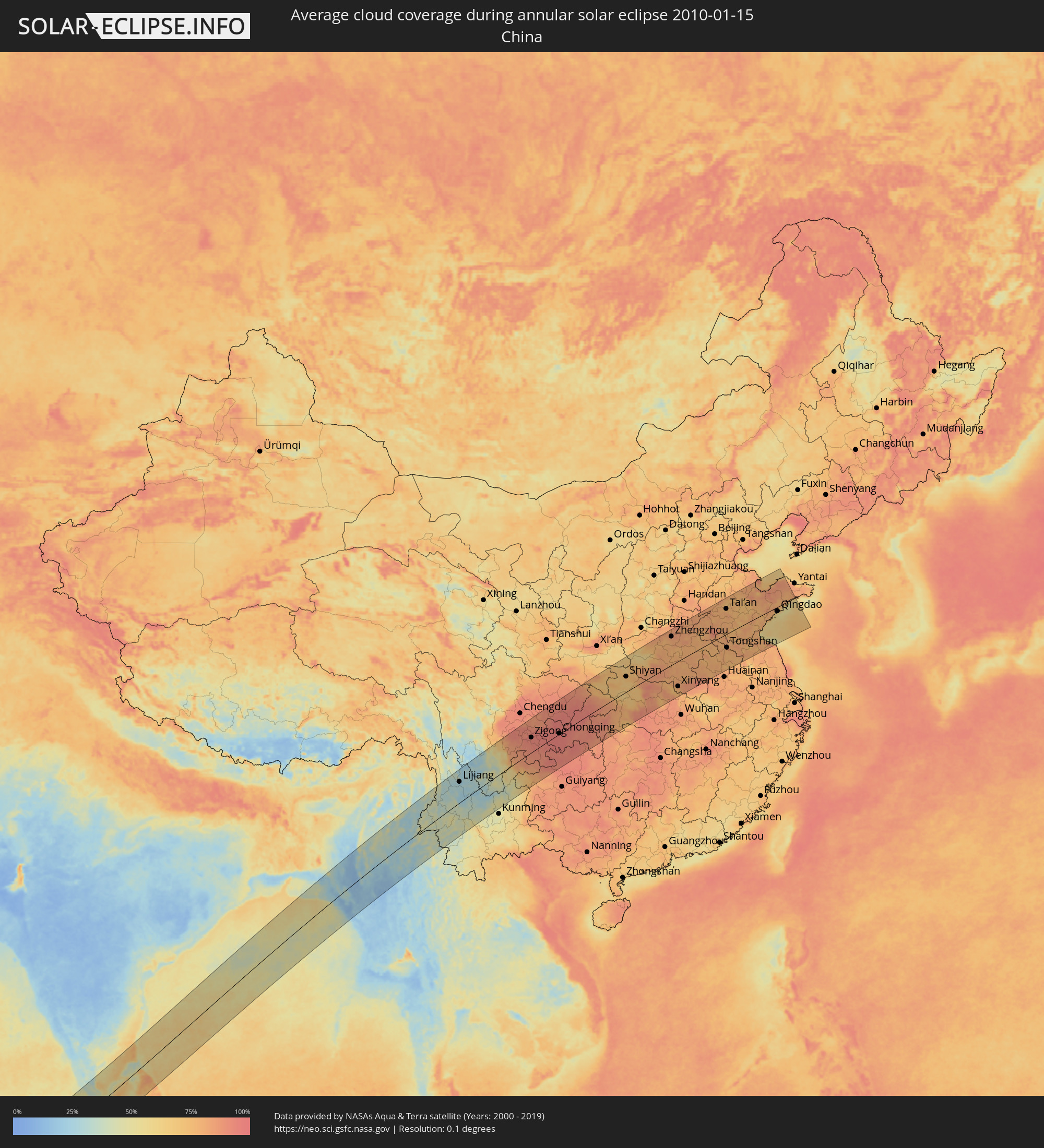 China
China
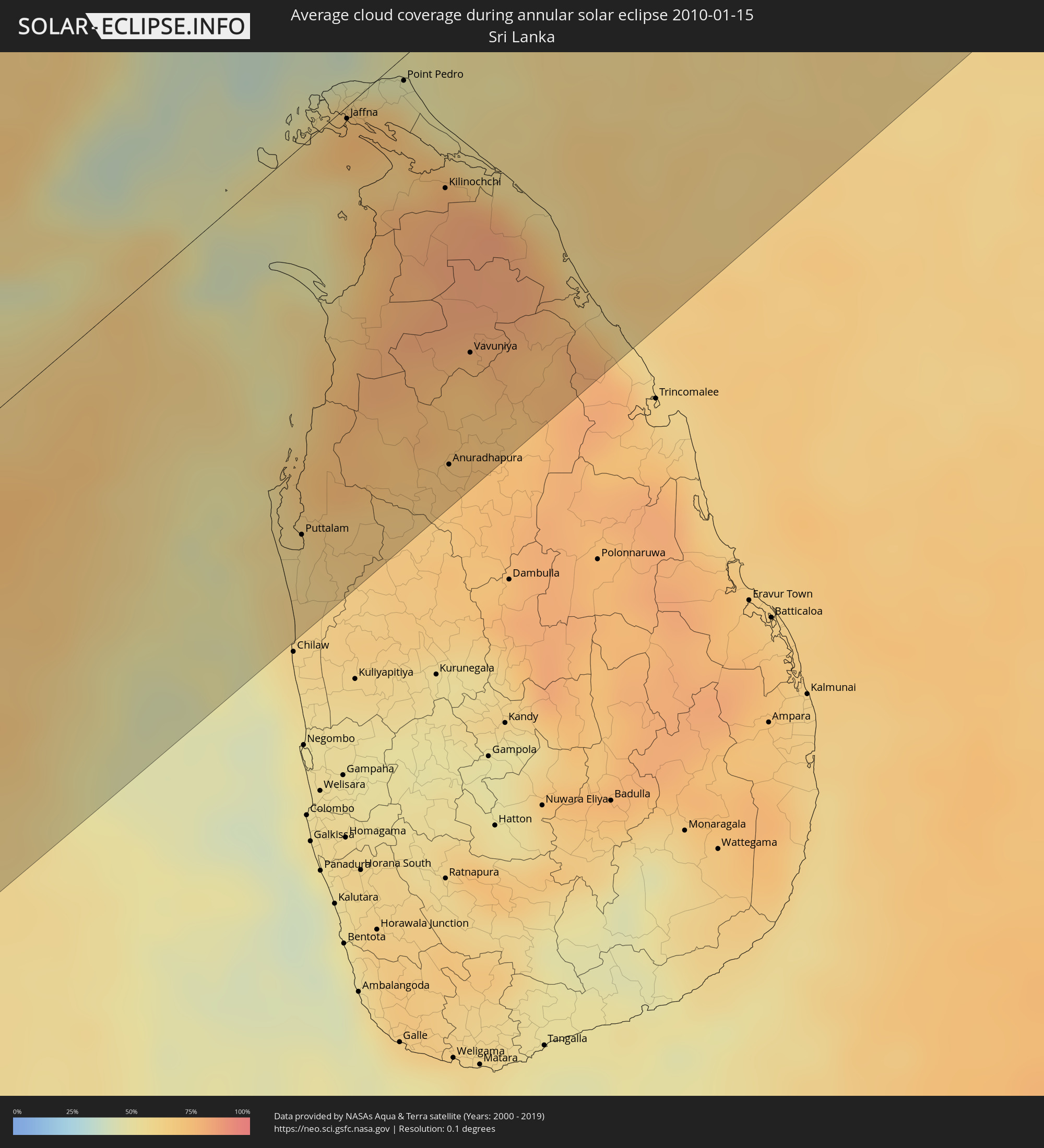 Sri Lanka
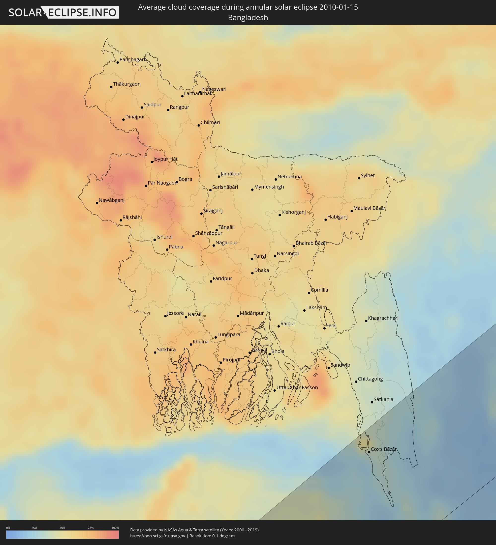 Bangladesh
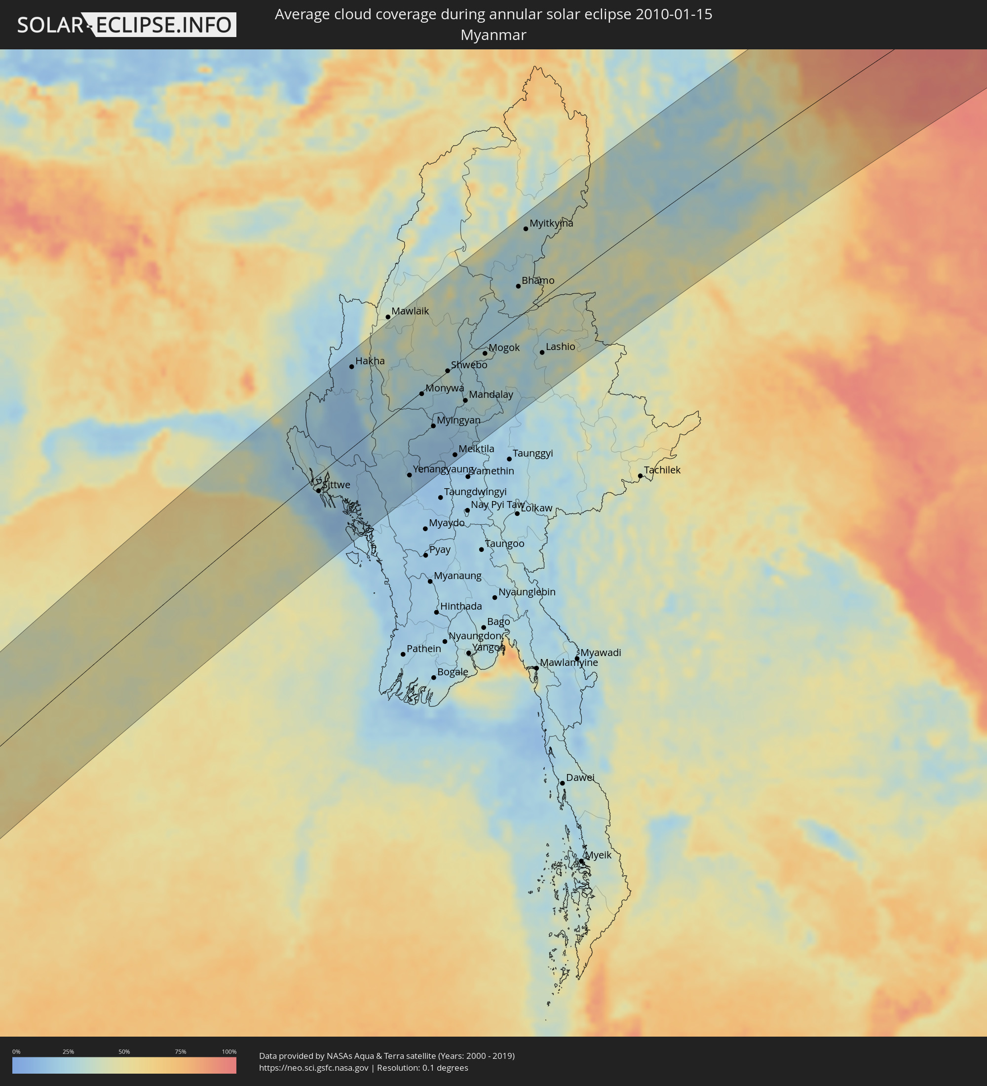 Myanmar
Cities inside the path of the eclipse
The following table shows all locations with a population of more than 5,000 inside the eclipse path. Cities which have more than 100,000 inhabitants are marked bold. A click at the locations opens a detailed map.
| City | Type | Eclipse duration | Local time of max. eclipse | Distance to central line | Ø Cloud coverage |
|
Bouar, Nana-Mambéré
|
annular | - | 06:17:06 UTC+01:00 | 110 km | 17% |
|
Moundou, Logone Occidental
|
annular | - | 06:18:26 UTC+01:00 | 183 km | 11% |
|
Bozoum, Ouham-Pendé
|
annular | - | 06:17:24 UTC+01:00 | 39 km | 20% |
|
Paoua, Ouham-Pendé
|
annular | - | 06:17:51 UTC+01:00 | 59 km | 15% |
|
Béboto, Logone Oriental
|
annular | - | 06:18:28 UTC+01:00 | 186 km | 13% |
|
Bossangoa, Ouham
|
annular | - | 06:17:44 UTC+01:00 | 22 km | 19% |
|
Batangafo, Ouham
|
annular | - | 06:18:21 UTC+01:00 | 139 km | 17% |
|
Bimbo, Ombella-M'Poko
|
annular | - | 06:17:04 UTC+01:00 | 172 km | 41% |
|
Bangui, Bangui
|
annular | - | 06:17:09 UTC+01:00 | 155 km | 38% |
|
Damara, Ombella-M'Poko
|
annular | - | 06:17:26 UTC+01:00 | 87 km | 32% |
|
Sibut, Kémo
|
annular | - | 06:17:52 UTC+01:00 | 6 km | 28% |
|
Kaga Bandoro, Nana-Grébizi
|
annular | - | 06:18:29 UTC+01:00 | 143 km | 21% |
|
Bosobolo, Équateur
|
annular | - | 06:17:31 UTC+01:00 | 121 km | 42% |
|
Bambari, Ouaka
|
annular | - | 06:18:28 UTC+01:00 | 75 km | 30% |
|
Businga, Équateur
|
annular | - | 06:17:35 UTC+01:00 | 170 km | 47% |
|
Gbadolite, Équateur
|
annular | - | 06:17:59 UTC+01:00 | 68 km | 40% |
|
Mobaye, Basse-Kotto
|
annular | - | 06:18:04 UTC+01:00 | 57 km | 36% |
|
Alindao, Basse-Kotto
|
annular | - | 06:18:22 UTC+01:00 | 18 km | 35% |
|
Ippy, Ouaka
|
annular | - | 06:18:56 UTC+01:00 | 148 km | 26% |
|
Bangassou, Mbomou
|
annular | - | 06:19:00 UTC+01:00 | 51 km | 34% |
|
Bondo, Orientale
|
annular | - | 07:19:05 UTC+02:00 | 13 km | 42% |
|
Aketi, Orientale
|
annular | - | 07:18:44 UTC+02:00 | 122 km | 53% |
|
Buta, Orientale
|
annular | - | 07:19:18 UTC+02:00 | 81 km | 59% |
|
Zemio, Haut-Mbomou
|
annular | - | 06:20:28 UTC+01:00 | 169 km | 32% |
|
Isiro, Orientale
|
annular | - | 07:21:16 UTC+02:00 | 24 km | 56% |
|
Wamba, Orientale
|
annular | - | 07:21:20 UTC+02:00 | 28 km | 66% |
|
Beni, Nord Kivu
|
annular | - | 07:22:00 UTC+02:00 | 151 km | 78% |
|
Watsa, Orientale
|
annular | - | 07:22:59 UTC+02:00 | 121 km | 47% |
|
Kasese, Western Region
|
annular | - | 08:22:27 UTC+03:00 | 162 km | 64% |
|
Bunia, Orientale
|
annular | - | 07:23:04 UTC+02:00 | 11 km | 58% |
|
Fort Portal, Western Region
|
annular | - | 08:22:46 UTC+03:00 | 105 km | 64% |
|
Arua, Northern Region
|
annular | - | 08:24:17 UTC+03:00 | 167 km | 39% |
|
Hoima, Western Region
|
annular | - | 08:24:05 UTC+03:00 | 14 km | 53% |
|
Masaka, Central Region
|
annular | - | 08:23:52 UTC+03:00 | 161 km | 67% |
|
Mityana, Central Region
|
annular | - | 08:24:25 UTC+03:00 | 72 km | 63% |
|
Entebbe, Central Region
|
annular | - | 08:24:45 UTC+03:00 | 95 km | 52% |
|
Kampala, Central Region
|
annular | - | 08:24:58 UTC+03:00 | 64 km | 57% |
|
Mukono, Central Region
|
annular | - | 08:25:11 UTC+03:00 | 54 km | 63% |
|
Lira, Northern Region
|
annular | - | 08:26:05 UTC+03:00 | 152 km | 37% |
|
Jinja, Eastern Region
|
annular | - | 08:25:42 UTC+03:00 | 31 km | 46% |
|
Iganga, Eastern Region
|
annular | - | 08:26:04 UTC+03:00 | 4 km | 45% |
|
Soroti, Eastern Region
|
annular | - | 08:26:40 UTC+03:00 | 119 km | 37% |
|
Busia, Eastern Region
|
annular | - | 08:26:45 UTC+03:00 | 1 km | 38% |
|
Busia, Busia
|
annular | - | 08:26:46 UTC+03:00 | 1 km | 38% |
|
Mbale, Eastern Region
|
annular | - | 08:27:05 UTC+03:00 | 69 km | 54% |
|
Tororo, Eastern Region
|
annular | - | 08:26:57 UTC+03:00 | 28 km | 38% |
|
Lugulu, Busia
|
annular | - | 08:26:59 UTC+03:00 | 1 km | 39% |
|
Sirari, Mara
|
annular | - | 08:26:38 UTC+03:00 | 171 km | 56% |
|
Mumias, Kakamega
|
annular | - | 08:27:11 UTC+03:00 | 1 km | 37% |
|
Bungoma, Bungoma
|
annular | - | 08:27:22 UTC+03:00 | 26 km | 37% |
|
Kakamega, Kakamega
|
annular | - | 08:27:29 UTC+03:00 | 2 km | 38% |
|
Kisumu, Kisumu
|
annular | - | 08:27:22 UTC+03:00 | 39 km | 27% |
|
Kitale, Trans Nzoia
|
annular | - | 08:28:06 UTC+03:00 | 88 km | 43% |
|
Kapenguria, West Pokot
|
annular | - | 08:28:20 UTC+03:00 | 115 km | 47% |
|
Eldoret, Uasin Gishu
|
annular | - | 08:28:14 UTC+03:00 | 43 km | 31% |
|
Nakuru, Nakuru
|
annular | - | 08:28:59 UTC+03:00 | 18 km | 43% |
|
Ol Kalou, Nyandarua
|
annular | - | 08:29:25 UTC+03:00 | 8 km | 46% |
|
Nairobi, Nairobi Area
|
annular | - | 08:29:39 UTC+03:00 | 104 km | 38% |
|
Nyeri, Nyeri
|
annular | - | 08:30:09 UTC+03:00 | 7 km | 38% |
|
Thika, Nairobi Area
|
annular | - | 08:30:06 UTC+03:00 | 70 km | 35% |
|
Meru, Meru
|
annular | - | 08:31:22 UTC+03:00 | 63 km | 48% |
|
Garissa, Garissa
|
annular | - | 08:34:16 UTC+03:00 | 64 km | 74% |
|
Kismayo, Lower Juba
|
annular | - | 08:39:31 UTC+03:00 | 144 km | 49% |
|
Kudahuvadhoo, Dhaalu Atholhu
|
annular | - | 12:20:52 UTC+05:00 | 119 km | 68% |
|
Ugoofaaru, Raa Atoll
|
annular | - | 12:27:01 UTC+05:00 | 142 km | 58% |
|
Eydhafushi, Baa Atholhu
|
annular | - | 12:26:05 UTC+05:00 | 89 km | 59% |
|
Naifaru, Lhaviyani Atholhu
|
annular | - | 12:27:42 UTC+05:00 | 100 km | 62% |
|
Manadhoo, Noonu Atoll
|
annular | - | 12:28:28 UTC+05:00 | 125 km | 65% |
|
Male, Kaafu Atoll
|
annular | - | 12:25:45 UTC+05:00 | 23 km | 62% |
|
Felidhoo, Vaavu Atholhu
|
annular | - | 12:24:32 UTC+05:00 | 88 km | 54% |
|
Muli, Meemu Atholhu
|
annular | - | 12:23:32 UTC+05:00 | 140 km | 64% |
|
Thiruvananthapuram, Kerala
|
annular | - | 13:14:16 UTC+05:30 | 116 km | 39% |
|
Neyyāttinkara, Kerala
|
annular | - | 13:14:31 UTC+05:30 | 99 km | 41% |
|
Nāgercoil, Tamil Nadu
|
annular | - | 13:15:07 UTC+05:30 | 55 km | 40% |
|
Rajapalaiyam, Tamil Nadu
|
annular | - | 13:17:40 UTC+05:30 | 155 km | 49% |
|
Tirunelveli, Tamil Nadu
|
annular | - | 13:16:47 UTC+05:30 | 84 km | 65% |
|
Kovilpatti, Tamil Nadu
|
annular | - | 13:18:04 UTC+05:30 | 108 km | 57% |
|
Aruppukkottai, Tamil Nadu
|
annular | - | 13:19:16 UTC+05:30 | 120 km | 57% |
|
Madurai, Tamil Nadu
|
annular | - | 13:20:01 UTC+05:30 | 153 km | 54% |
|
Paramagudi, Tamil Nadu
|
annular | - | 13:20:41 UTC+05:30 | 88 km | 69% |
|
Kāraikkudi, Tamil Nadu
|
annular | - | 13:22:02 UTC+05:30 | 119 km | 64% |
|
Pudukkottai, Tamil Nadu
|
annular | - | 13:22:41 UTC+05:30 | 141 km | 64% |
|
Thanjāvūr, Tamil Nadu
|
annular | - | 13:24:11 UTC+05:30 | 152 km | 67% |
|
Kumbakonam, Tamil Nadu
|
annular | - | 13:25:08 UTC+05:30 | 149 km | 73% |
|
Mayiladuthurai, Tamil Nadu
|
annular | - | 13:26:03 UTC+05:30 | 141 km | 75% |
|
Puttalam, North Western
|
annular | - | 13:21:26 UTC+05:30 | 128 km | 58% |
|
Kāraikāl, Pondicherry
|
annular | - | 13:26:12 UTC+05:30 | 113 km | 62% |
|
Nāgappattinam, Tamil Nadu
|
annular | - | 13:26:00 UTC+05:30 | 99 km | 62% |
|
Jaffna, Northern Province
|
annular | - | 13:24:38 UTC+05:30 | 4 km | 74% |
|
Valvedditturai, Northern Province
|
annular | - | 13:25:18 UTC+05:30 | 3 km | 64% |
|
Point Pedro, Northern Province
|
annular | - | 13:25:28 UTC+05:30 | 8 km | 64% |
|
Kilinochchi, Northern Province
|
annular | - | 13:25:12 UTC+05:30 | 55 km | 80% |
|
Anuradhapura, North Central
|
annular | - | 13:23:25 UTC+05:30 | 147 km | 71% |
|
Vavuniya, Northern Province
|
annular | - | 13:24:23 UTC+05:30 | 116 km | 76% |
|
Cox’s Bāzār, Chittagong
|
annular | - | 14:32:32 UTC+06:00 | 140 km | 25% |
|
Teknāf, Chittagong
|
annular | - | 14:32:33 UTC+06:00 | 71 km | 24% |
|
Sittwe, Rakhine
|
annular | - | 15:02:54 UTC+06:30 | 30 km | 16% |
|
Chauk, Magway
|
annular | - | 15:06:07 UTC+06:30 | 90 km | 19% |
|
Yenangyaung, Magway
|
annular | - | 15:05:53 UTC+06:30 | 131 km | 20% |
|
Minbu, Magway
|
annular | - | 15:05:42 UTC+06:30 | 156 km | 18% |
|
Magway, Magway
|
annular | - | 15:05:45 UTC+06:30 | 163 km | 17% |
|
Pakokku, Magway
|
annular | - | 15:06:45 UTC+06:30 | 69 km | 20% |
|
Monywa, Sagain
|
annular | - | 15:07:18 UTC+06:30 | 5 km | 24% |
|
Myingyan, Mandalay
|
annular | - | 15:07:14 UTC+06:30 | 77 km | 19% |
|
Shwebo, Sagain
|
annular | - | 15:08:17 UTC+06:30 | 0 km | 32% |
|
Meiktila, Mandalay
|
annular | - | 15:07:28 UTC+06:30 | 159 km | 15% |
|
Sagaing, Sagain
|
annular | - | 15:08:15 UTC+06:30 | 78 km | 25% |
|
Mandalay, Mandalay
|
annular | - | 15:08:26 UTC+06:30 | 77 km | 27% |
|
Pyin Oo Lwin, Mandalay
|
annular | - | 15:08:56 UTC+06:30 | 95 km | 33% |
|
Mogok, Mandalay
|
annular | - | 15:09:29 UTC+06:30 | 20 km | 30% |
|
Myitkyina, Kachin
|
annular | - | 15:11:37 UTC+06:30 | 143 km | 38% |
|
Lashio, Shan
|
annular | - | 15:10:58 UTC+06:30 | 96 km | 35% |
|
Lijiang, Yunnan
|
annular | - | 16:45:03 UTC+08:00 | 107 km | 25% |
|
Nanchong, Sichuan
|
annular | - | 16:50:19 UTC+08:00 | 142 km | 92% |
|
Chongqing, Chongqing
|
annular | - | 16:50:40 UTC+08:00 | 2 km | 97% |
|
Shiyan, Hubei
|
annular | - | 16:52:58 UTC+08:00 | 78 km | 72% |
|
Pingdingshan, Henan
|
annular | - | 16:53:55 UTC+08:00 | 62 km | 80% |
|
Zhengzhou, Henan
|
annular | - | 16:53:46 UTC+08:00 | 144 km | 83% |
|
Nangandao, Henan
|
annular | - | 16:53:42 UTC+08:00 | 179 km | 83% |
|
Xinyang, Henan
|
annular | - | 16:54:37 UTC+08:00 | 130 km | 80% |
|
Kaifeng, Henan
|
annular | - | 16:54:02 UTC+08:00 | 118 km | 82% |
|
Huaibei, Anhui
|
annular | - | 16:55:11 UTC+08:00 | 74 km | 81% |
|
Jinan, Shandong
|
annular | - | 16:54:17 UTC+08:00 | 180 km | 77% |
|
Tai’an, Shandong
|
annular | - | 16:54:31 UTC+08:00 | 127 km | 77% |
|
Tongshan, Jiangsu
|
annular | - | 16:55:15 UTC+08:00 | 70 km | 81% |
|
Zibo, Shandong
|
annular | - | 16:54:32 UTC+08:00 | 146 km | 77% |
|
Zhu Cheng City, Shandong
|
annular | - | 16:55:14 UTC+08:00 | 11 km | 79% |
|
Qingdao, Shandong
|
annular | - | 16:55:26 UTC+08:00 | 22 km | 62% |