Total solar eclipse of 09/10/2295
| Day of week: | Tuesday |
| Maximum duration of eclipse: | 03m01s |
| Maximum width of eclipse path: | 104 km |
| Saros cycle: | 149 |
| Coverage: | 100% |
| Magnitude: | 1.0307 |
| Gamma: | 0.0963 |
Wo kann man die Sonnenfinsternis vom 09/10/2295 sehen?

Die Sonnenfinsternis am 09/10/2295 kann man in 61 Ländern als partielle Sonnenfinsternis beobachten.
Der Finsternispfad verläuft durch 15 Länder. Nur in diesen Ländern ist sie als total Sonnenfinsternis zu sehen.
In den folgenden Ländern ist die Sonnenfinsternis total zu sehen
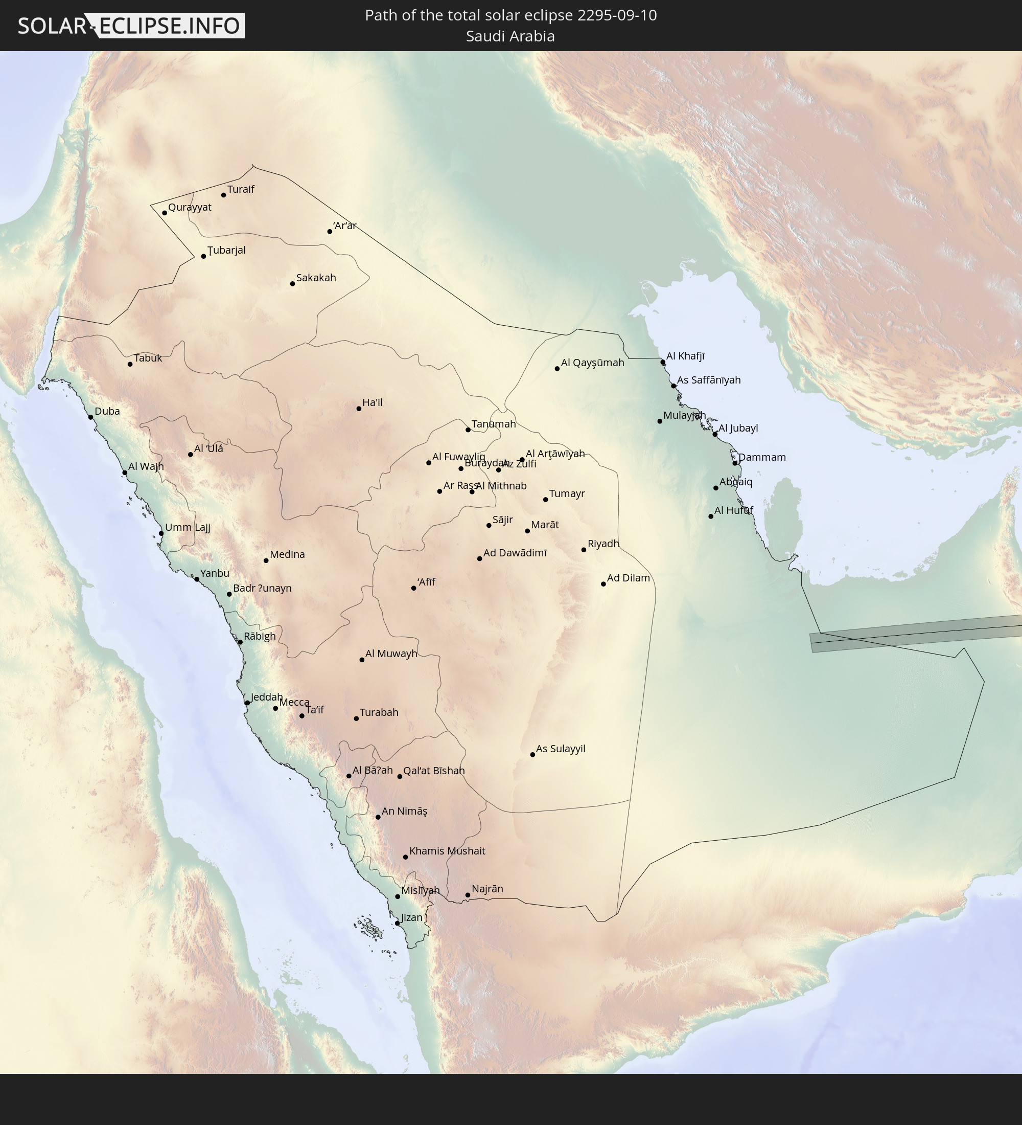 Saudi Arabia
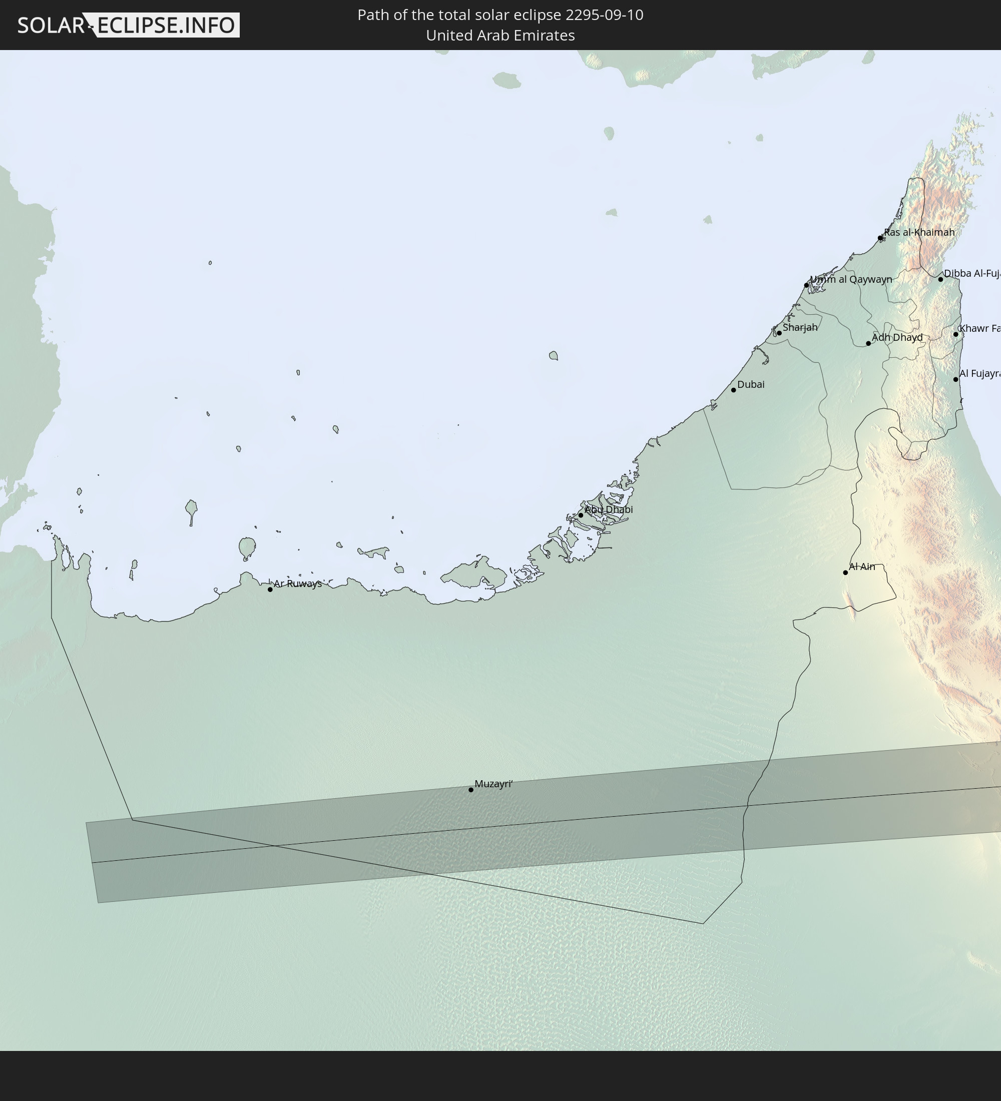 United Arab Emirates
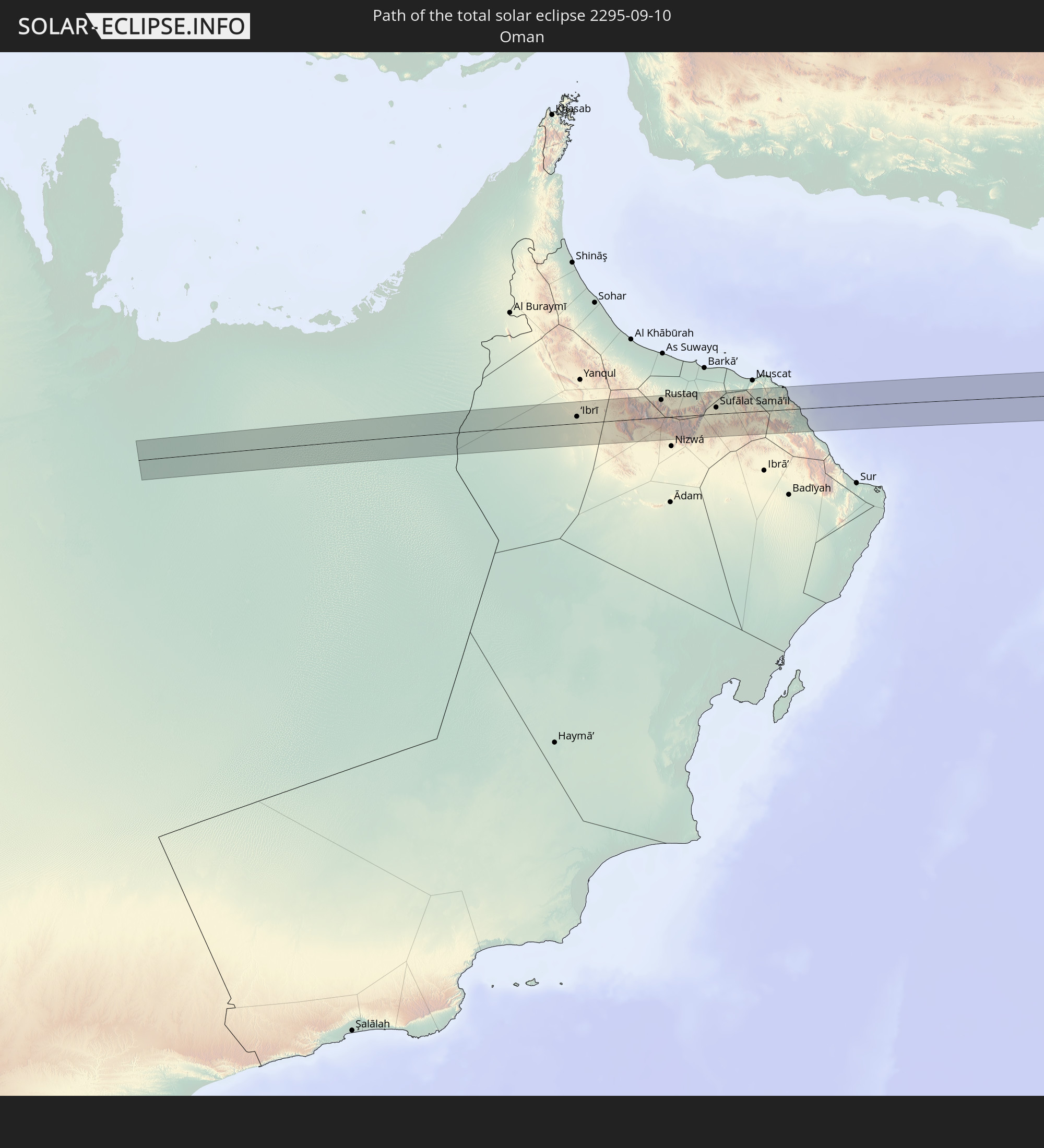 Oman
Oman
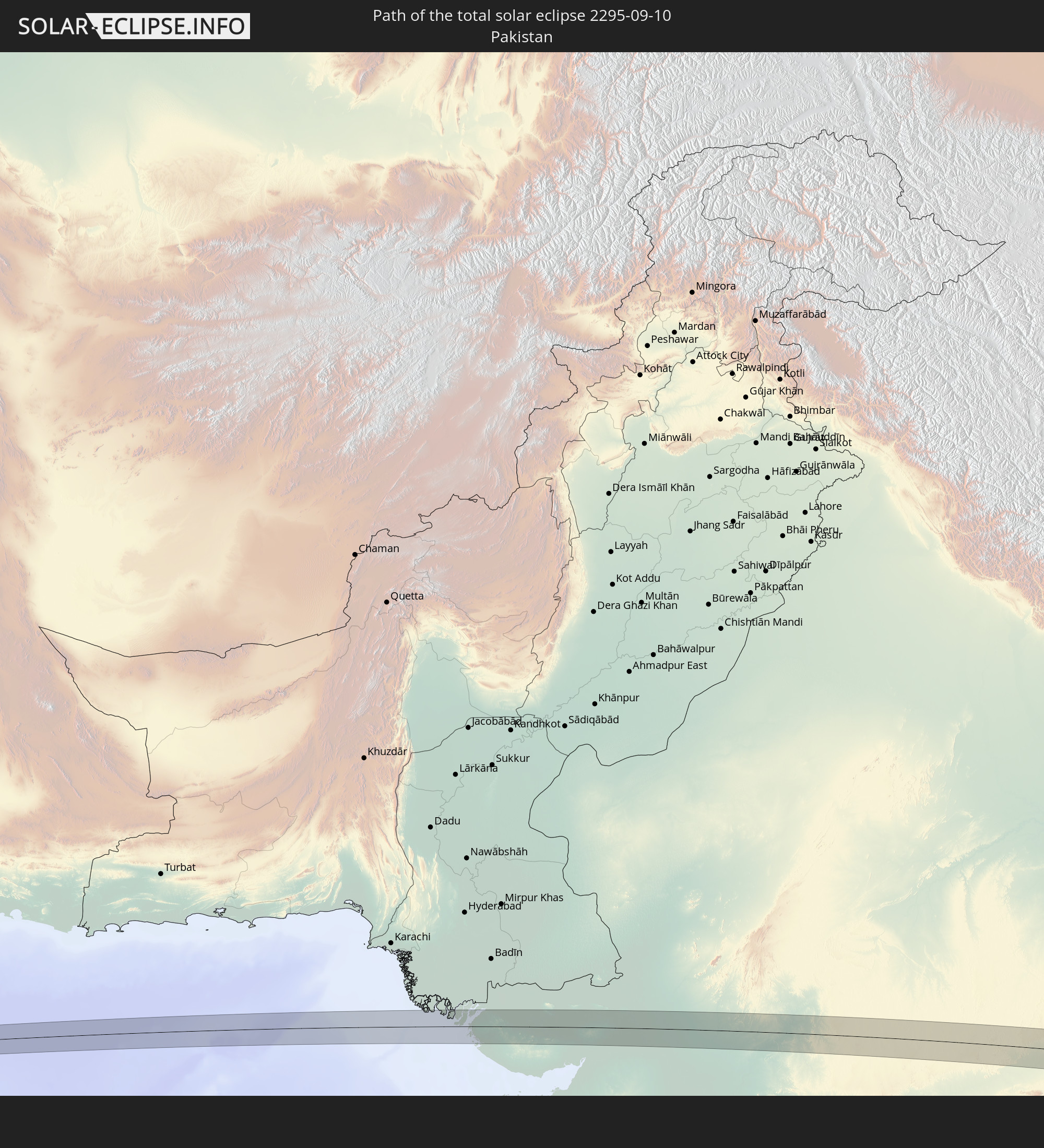 Pakistan
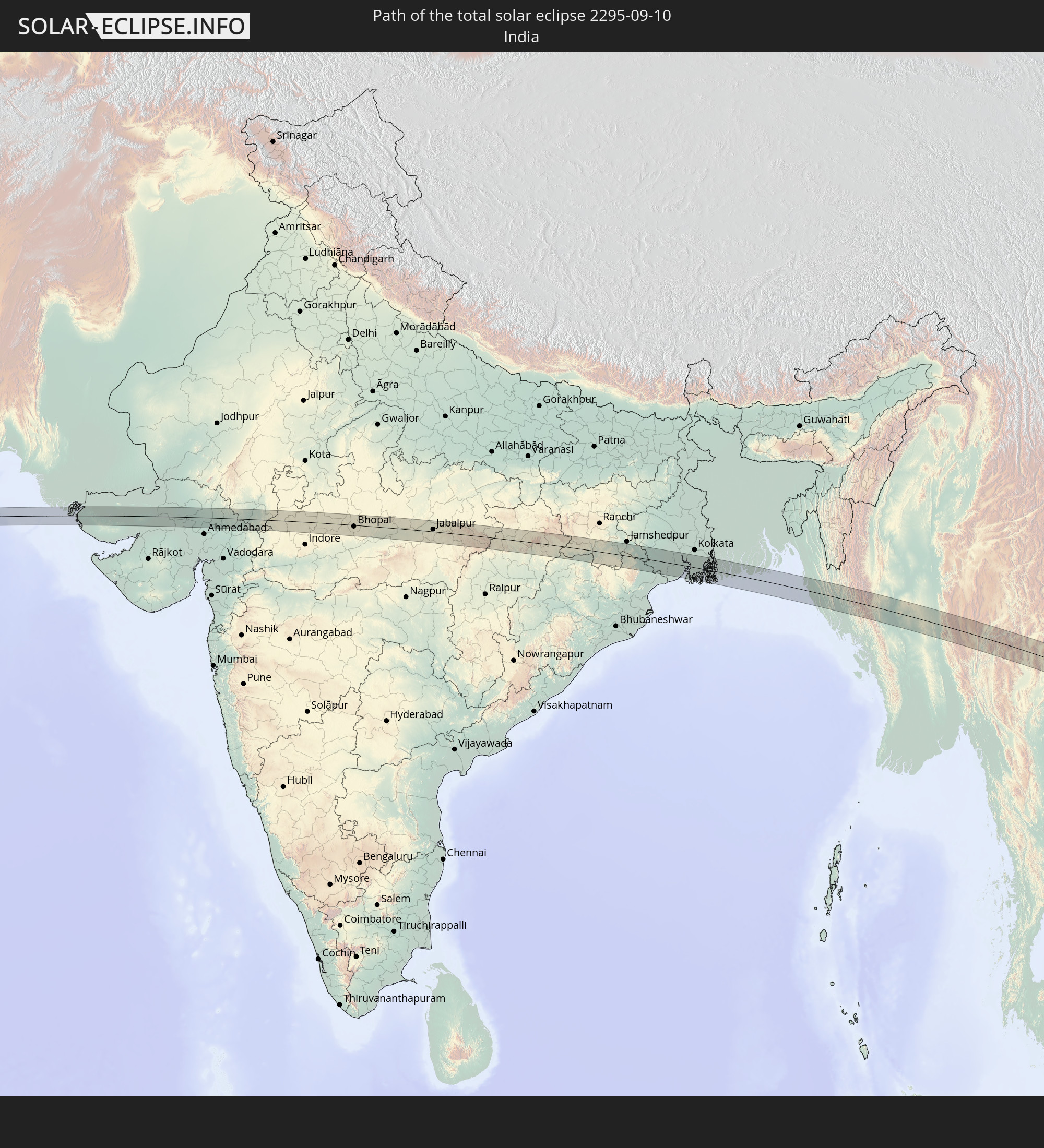 India
India
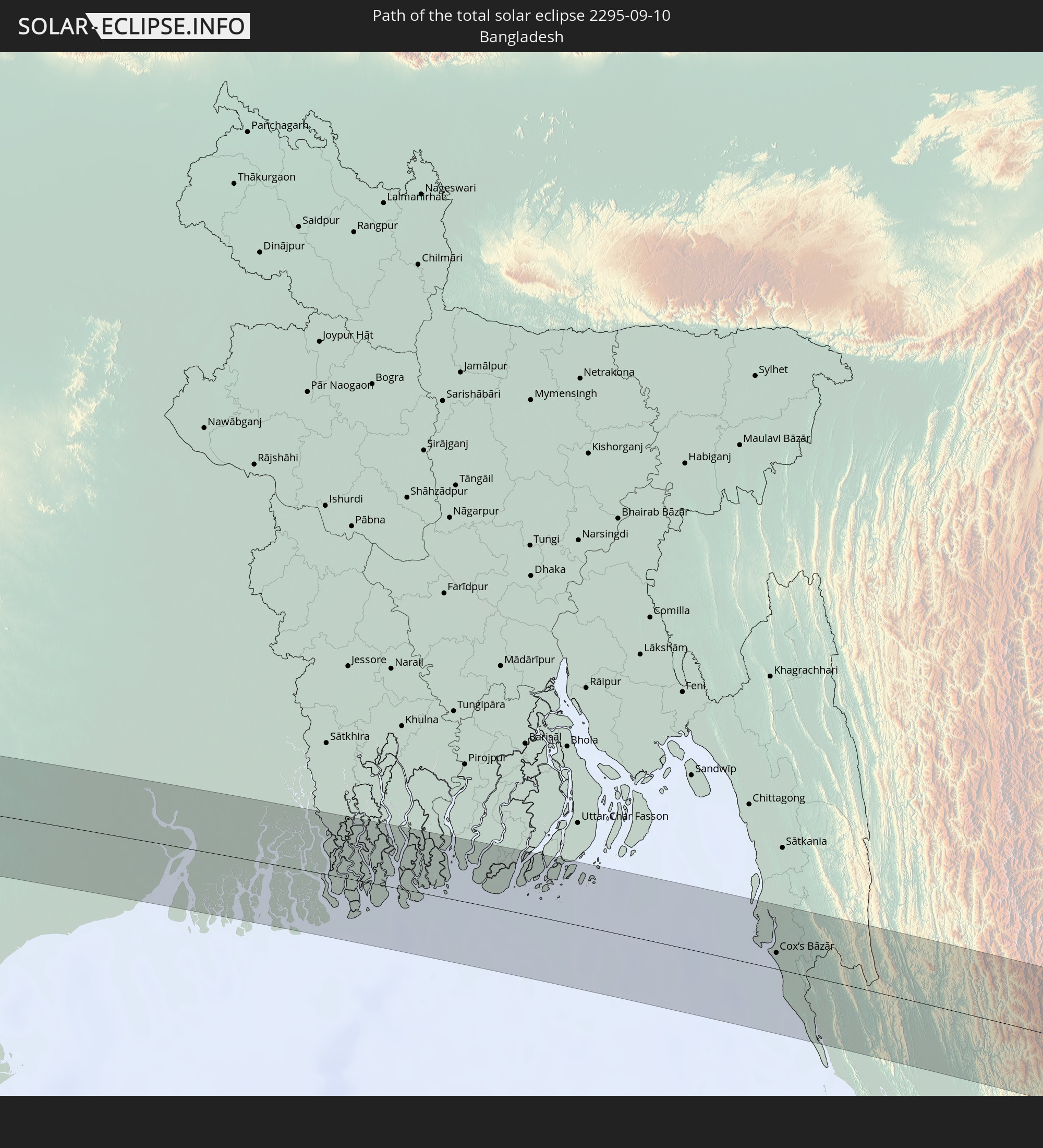 Bangladesh
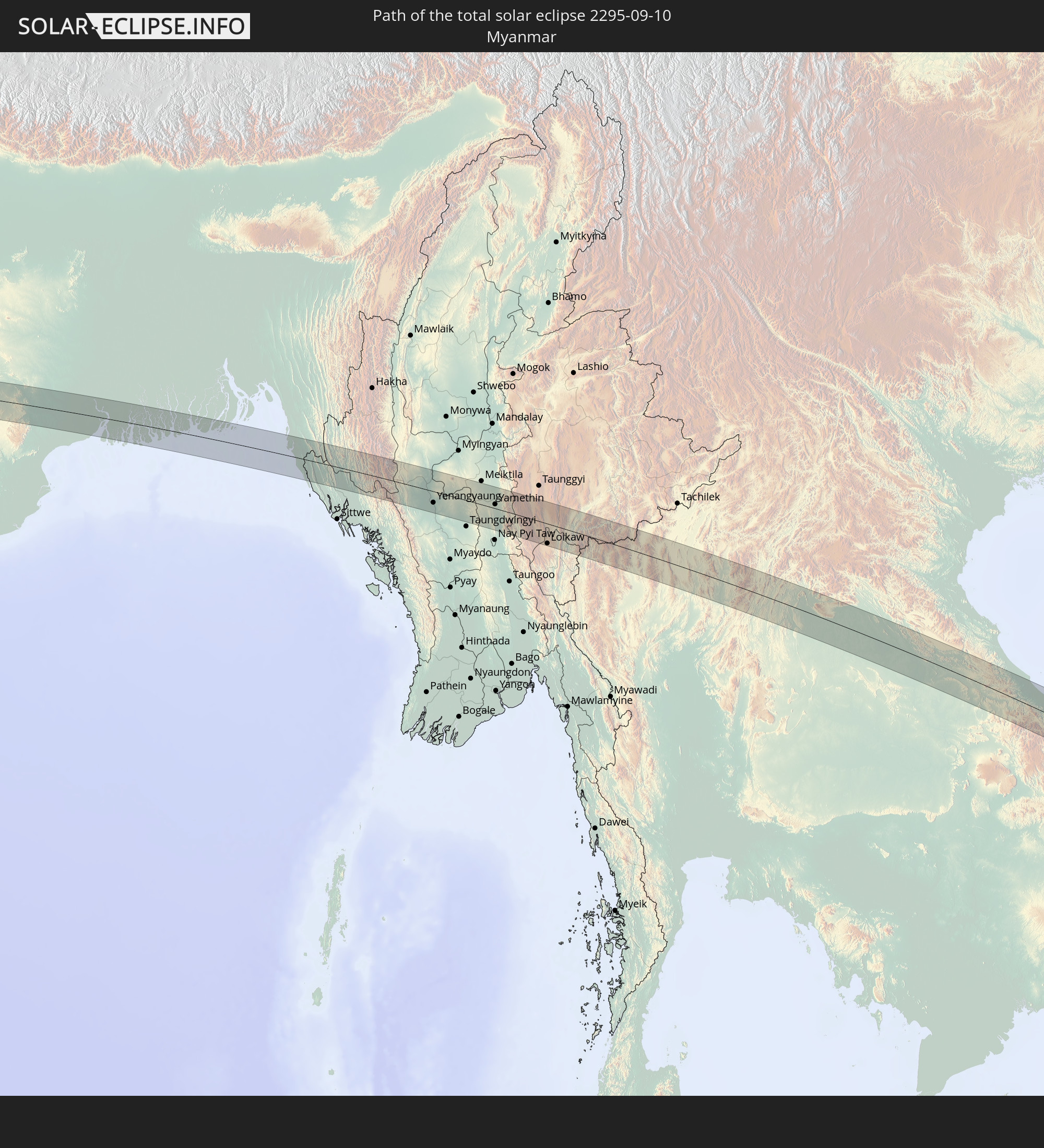 Myanmar
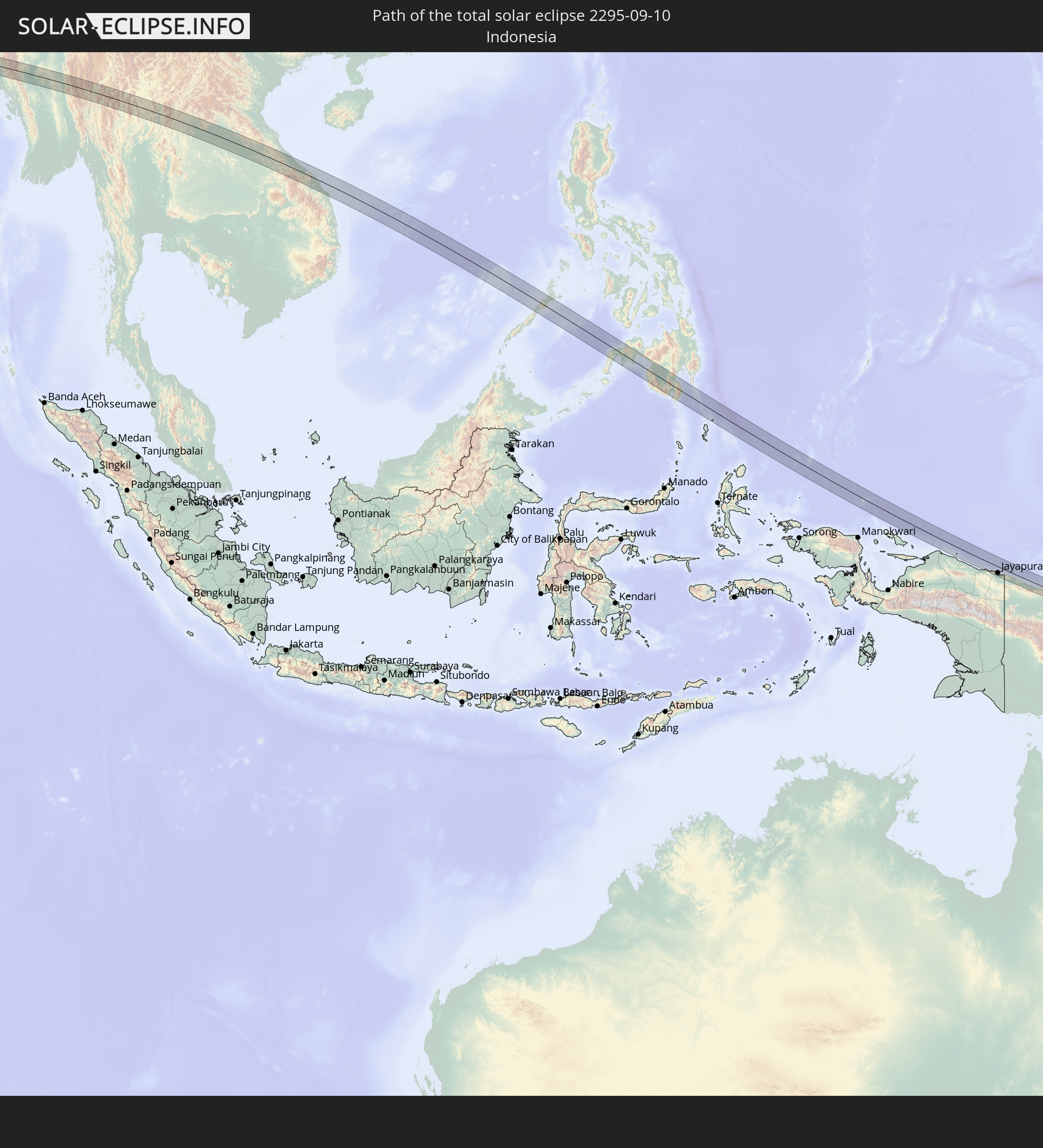 Indonesia
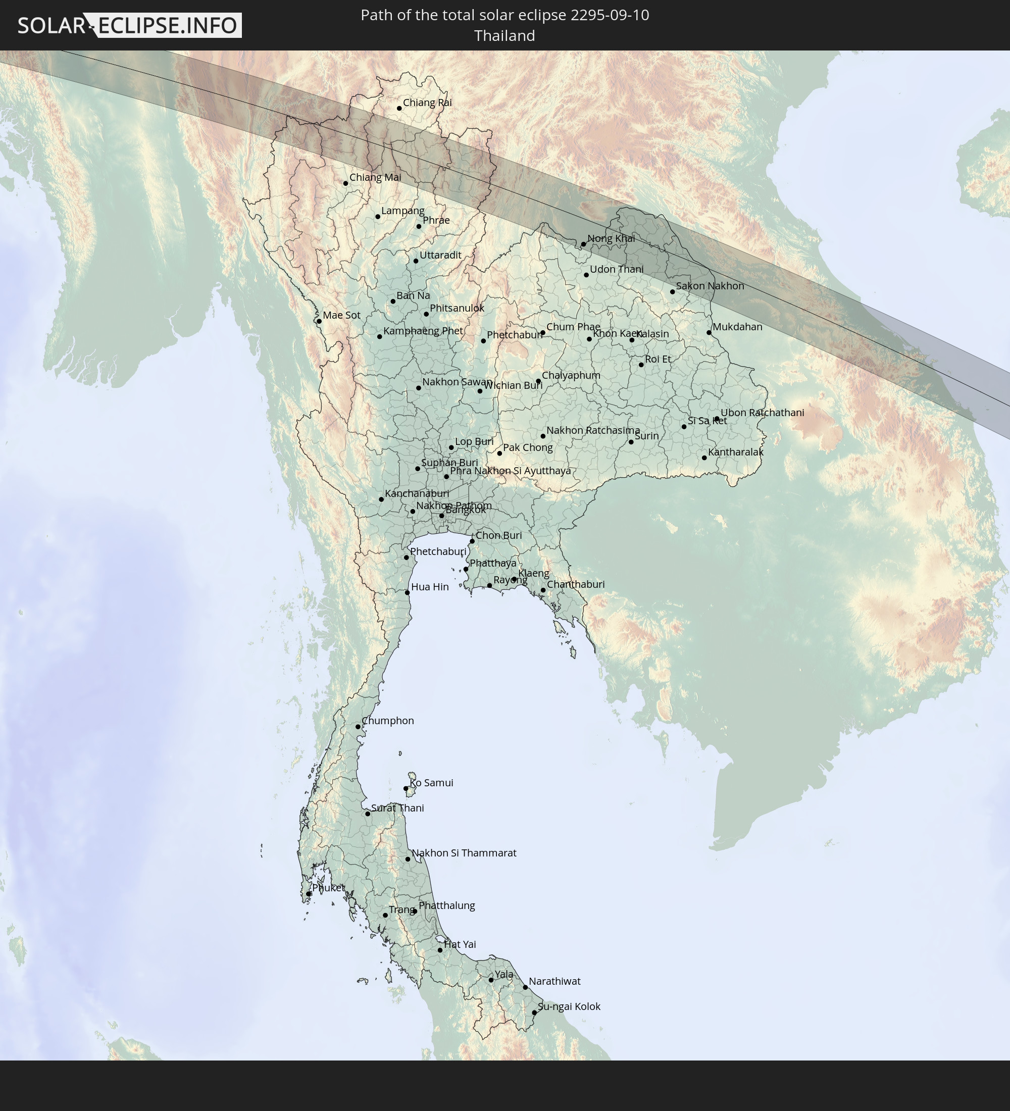 Thailand
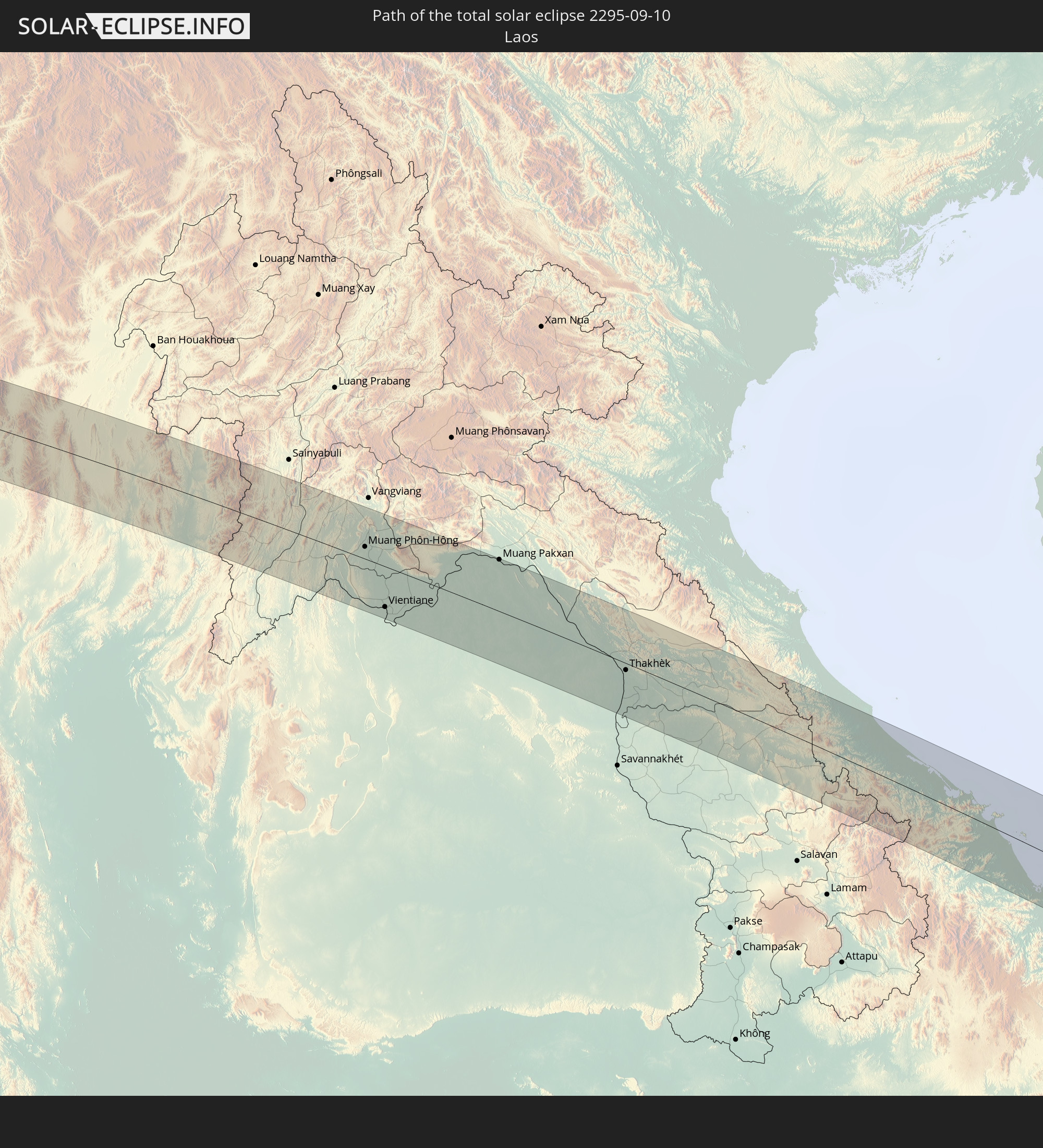 Laos
Laos
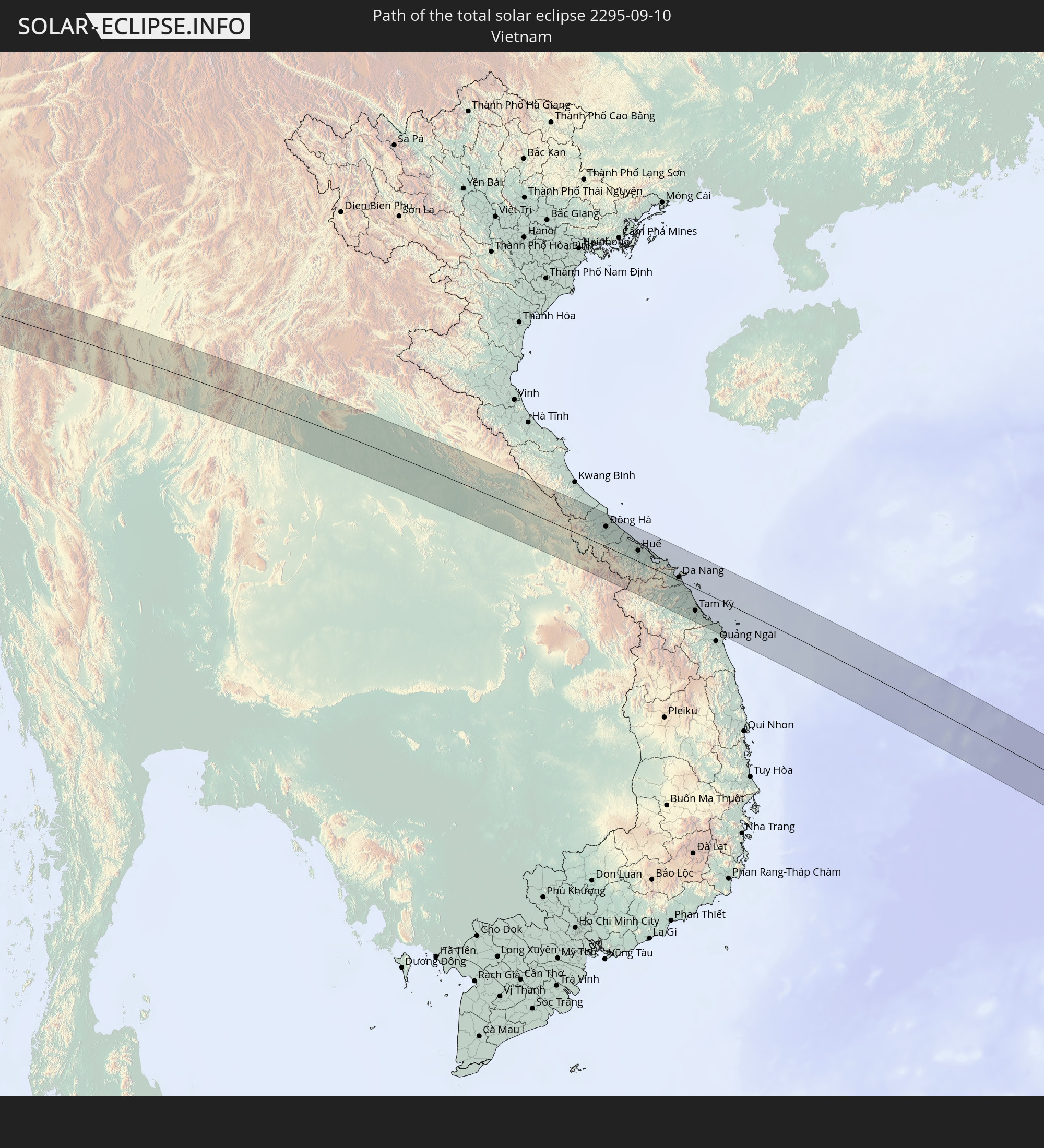 Vietnam
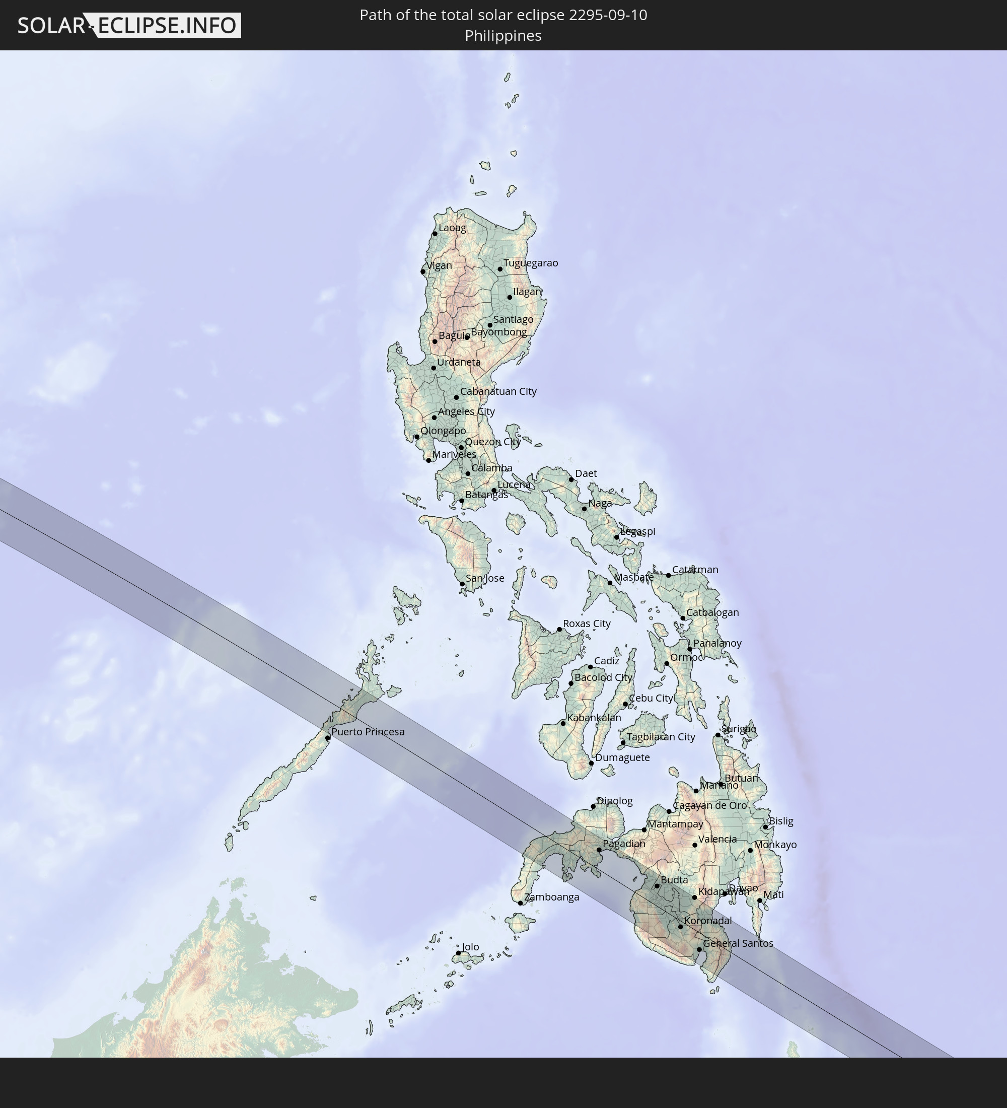 Philippines
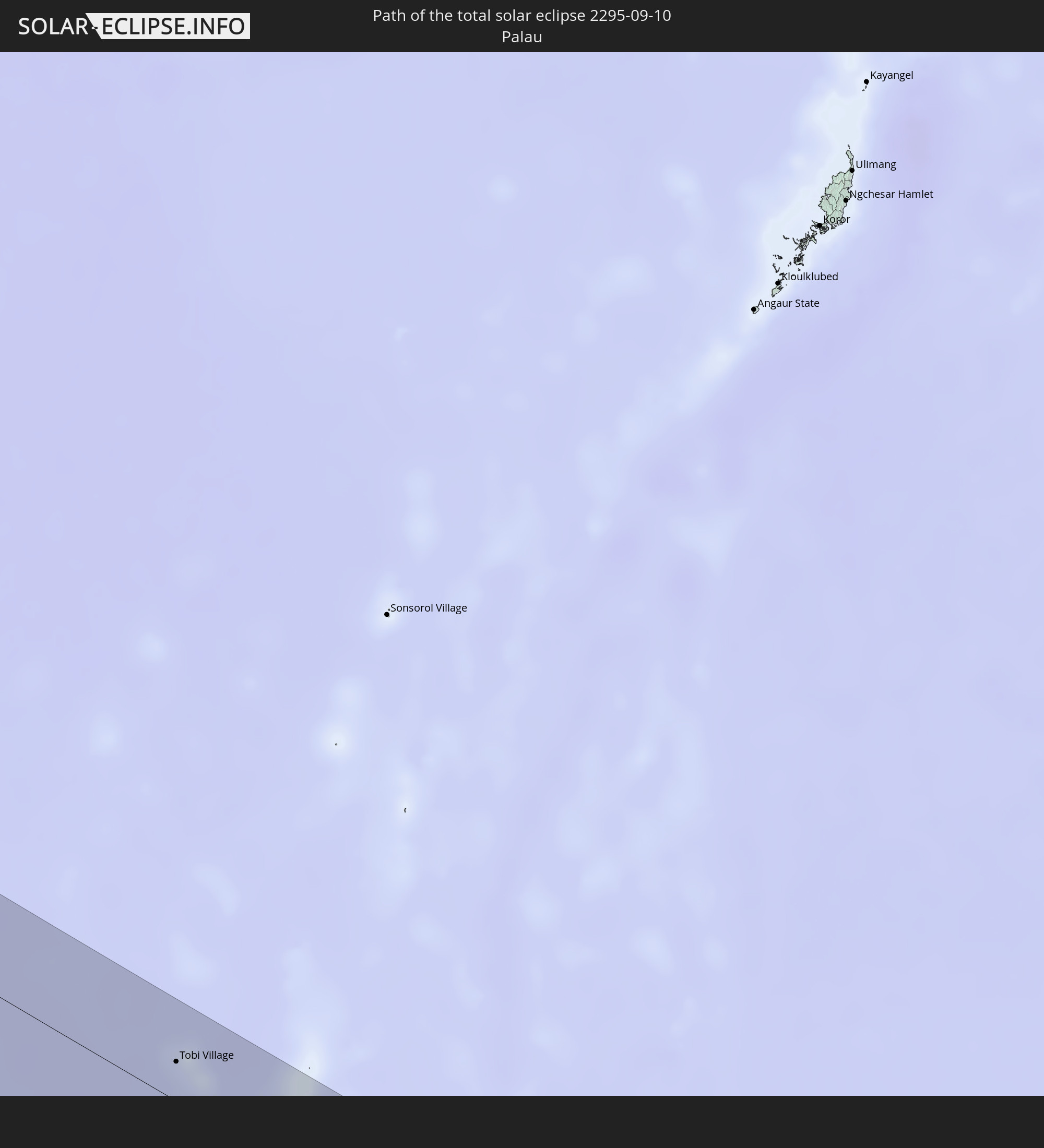 Palau
Palau
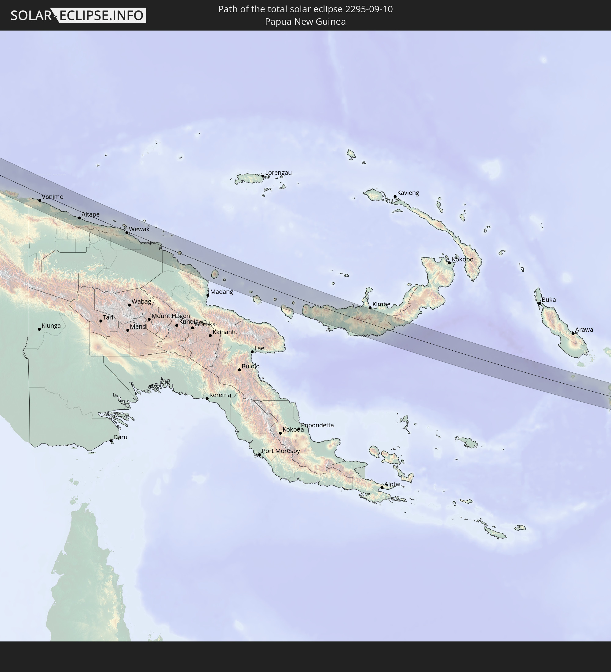 Papua New Guinea
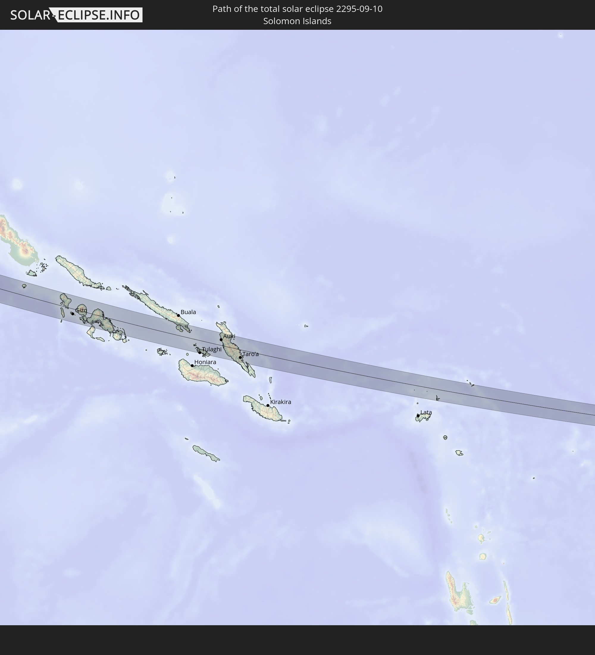 Solomon Islands
In den folgenden Ländern ist die Sonnenfinsternis partiell zu sehen
 Fiji
Fiji
 Russia
 New Zealand
 United States Minor Outlying Islands
 Kiribati
 Saudi Arabia
 Yemen
Yemen
 Iran
Iran
 Azerbaijan
 Seychelles
 Kazakhstan
 Qatar
Qatar
 United Arab Emirates
 Oman
Oman
 Turkmenistan
 Uzbekistan
 Afghanistan
 Pakistan
 Tajikistan
 India
India
 Kyrgyzstan
 British Indian Ocean Territory
 Maldives
 China
China
 Sri Lanka
 Nepal
Nepal
 Mongolia
 Bangladesh
 Bhutan
 Myanmar
 Indonesia
 Cocos Islands
 Thailand
 Malaysia
 Laos
Laos
 Vietnam
 Cambodia
 Singapore
 Christmas Island
 Australia
 Macau
Macau
 Hong Kong
 Brunei
 Taiwan
 Philippines
 Japan
Japan
 East Timor
 North Korea
 South Korea
 Palau
Palau
 Federated States of Micronesia
 Papua New Guinea
 Guam
Guam
 Northern Mariana Islands
 Solomon Islands
 New Caledonia
 Marshall Islands
 Vanuatu
 Nauru
Nauru
 Norfolk Island
 Tuvalu
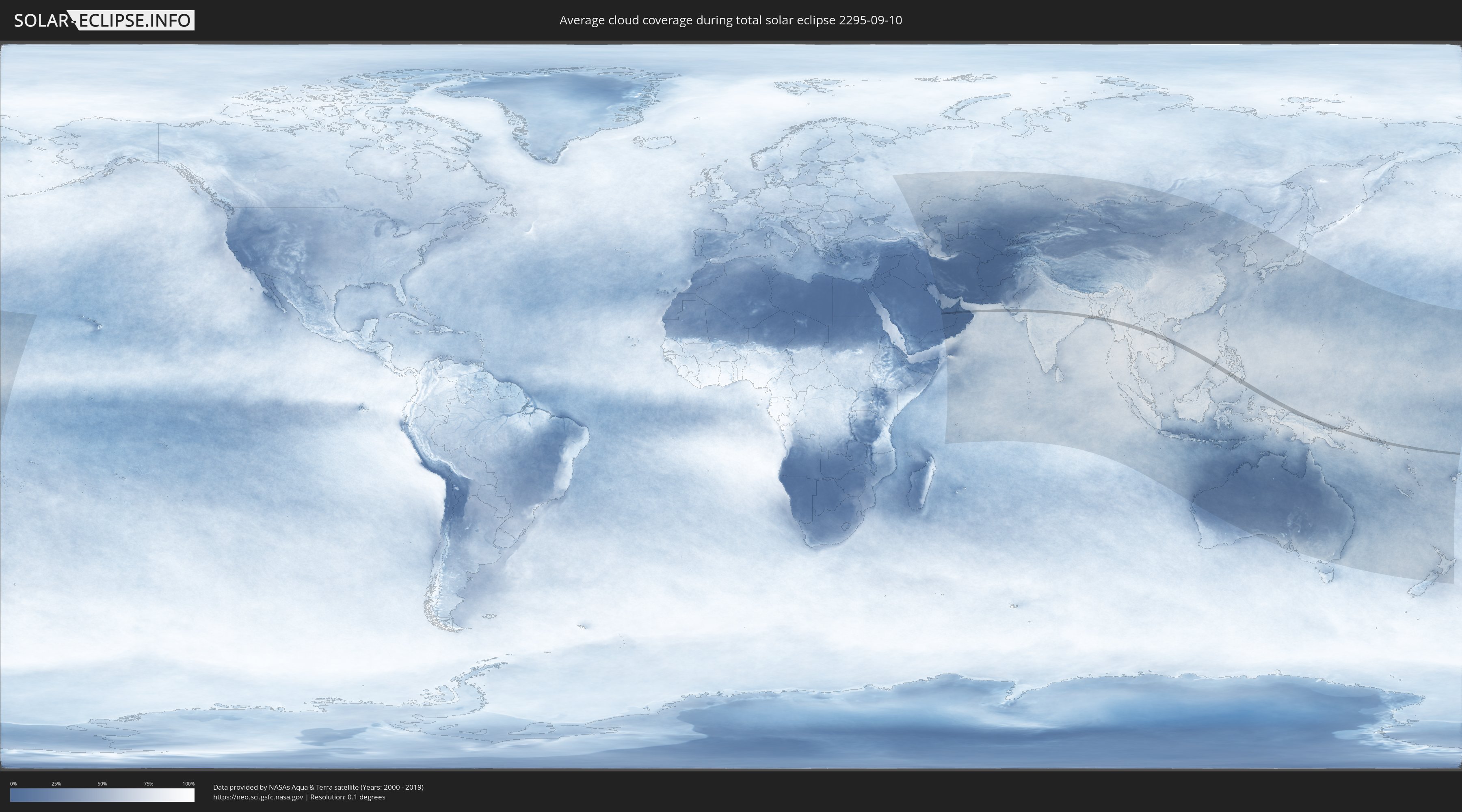
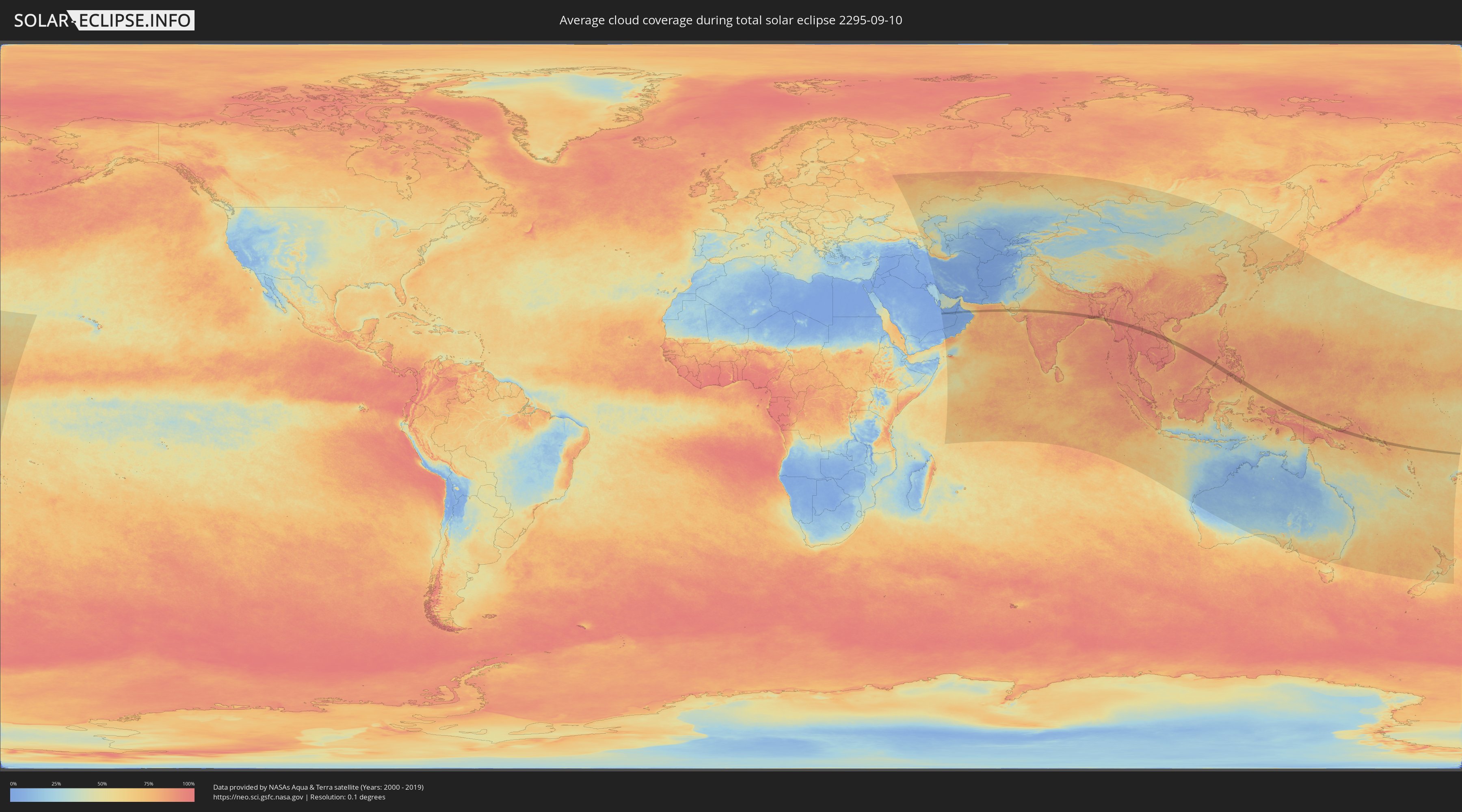
How will be the weather during the total solar eclipse on 09/10/2295?
Where is the best place to see the total solar eclipse of 09/10/2295?
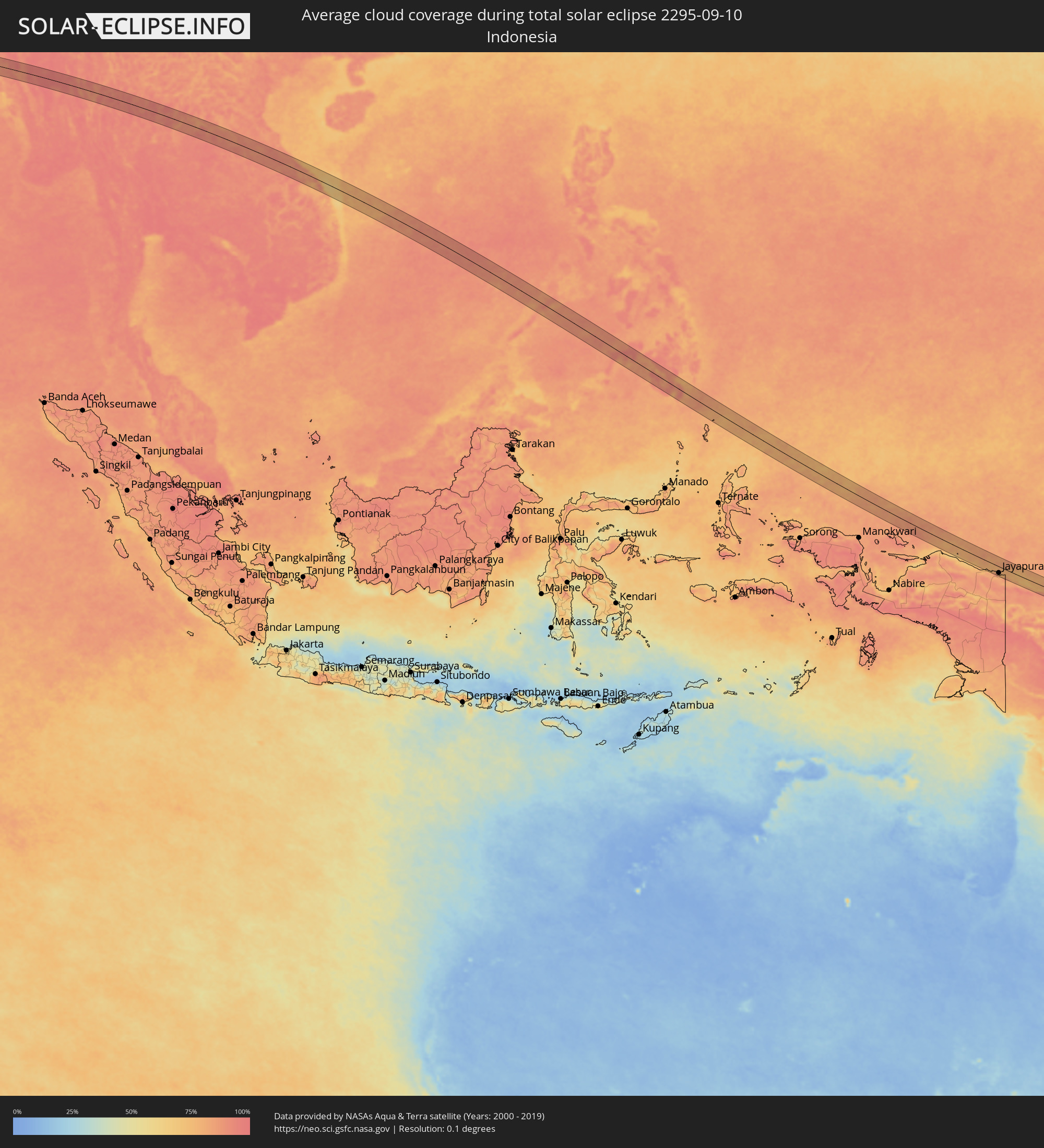
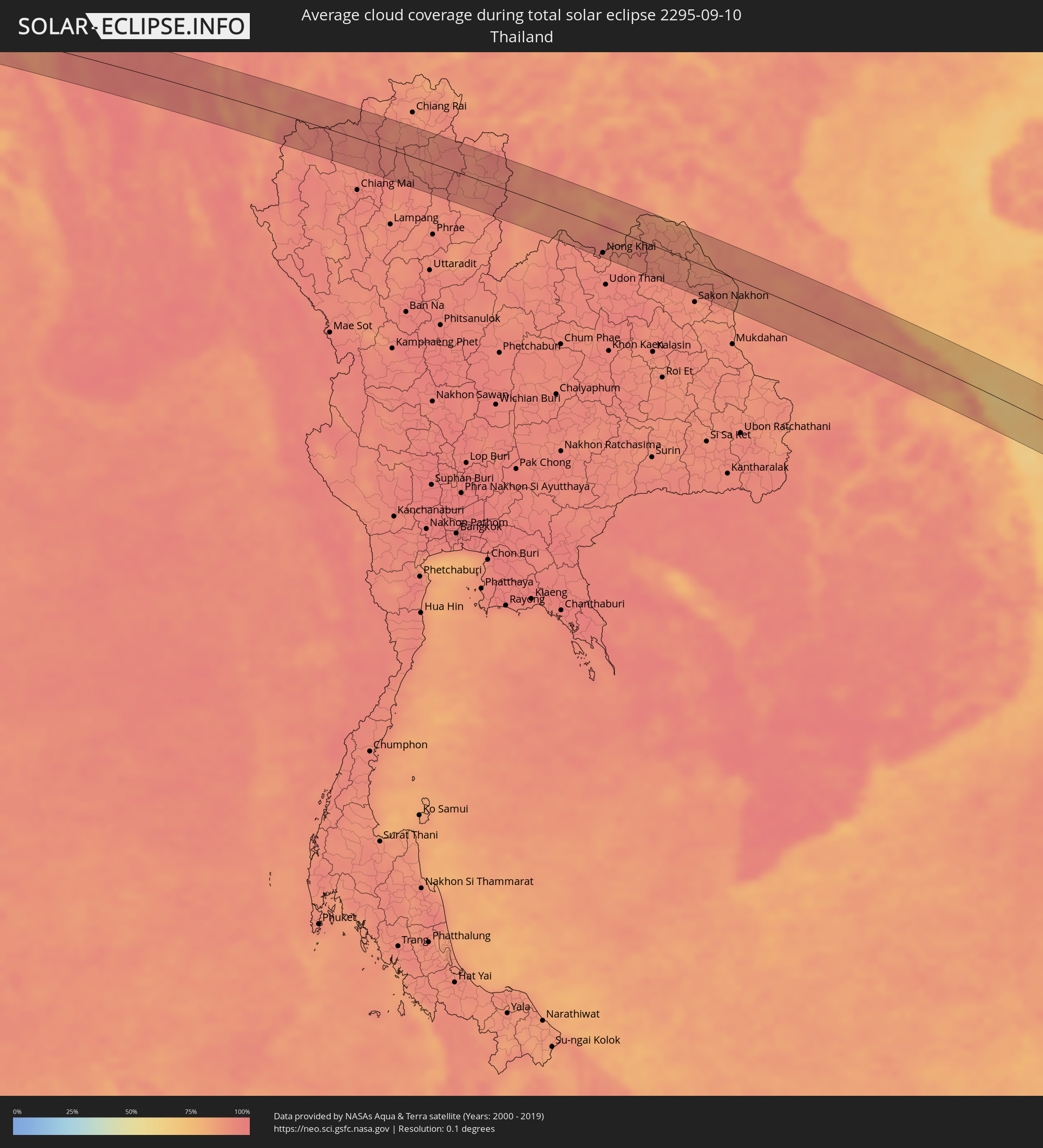
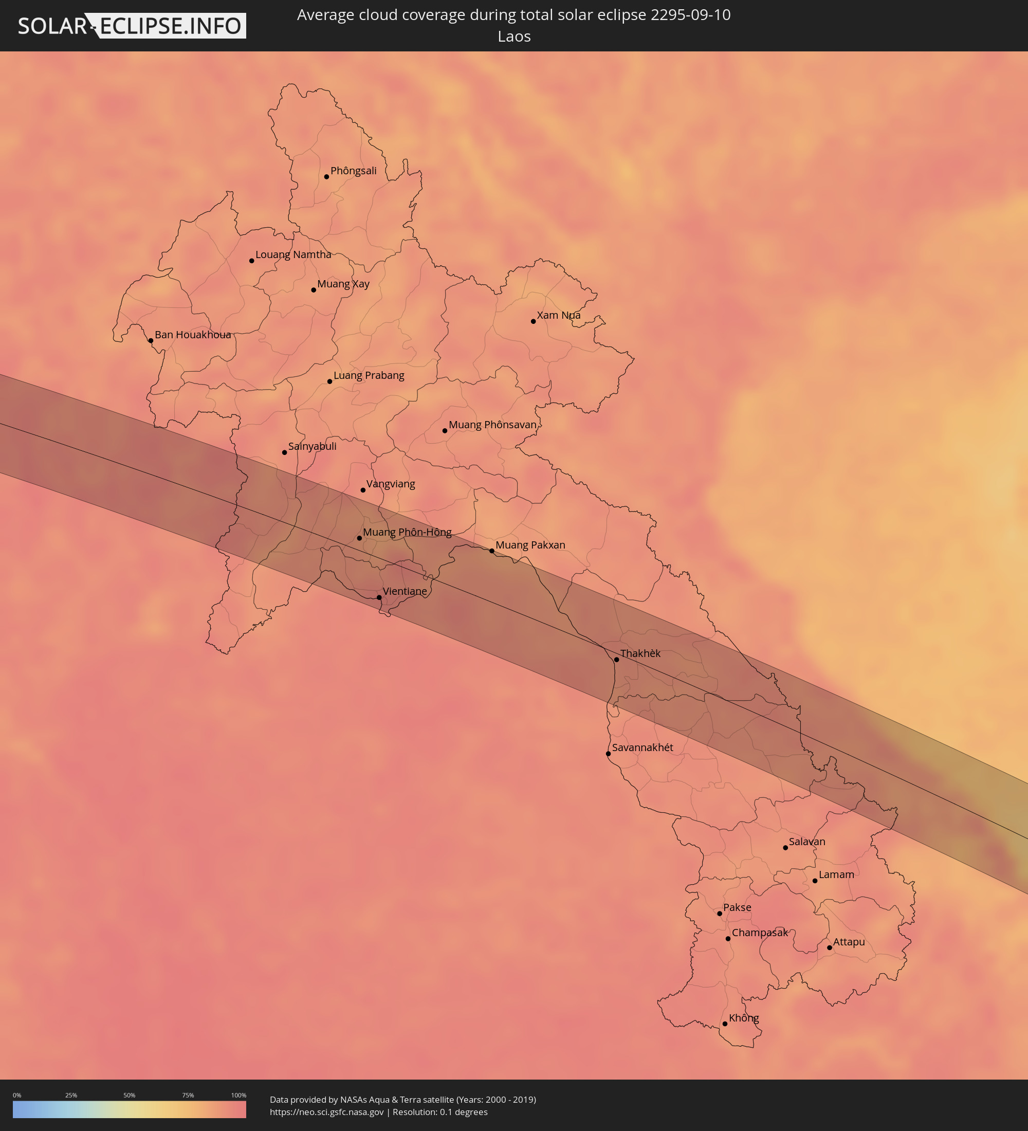
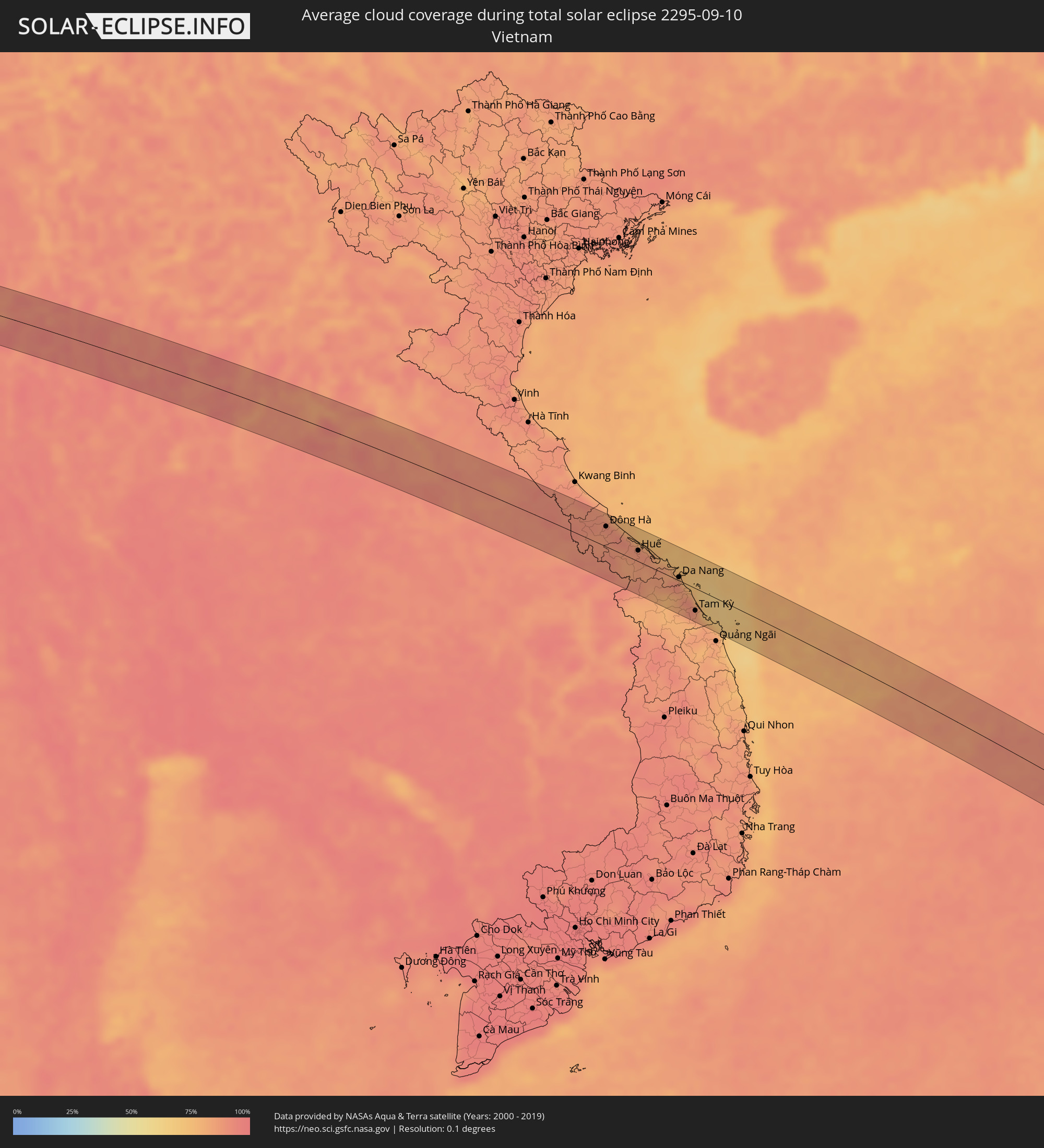
The following maps show the average cloud coverage for the day of the total solar eclipse.
With the help of these maps, it is possible to find the place along the eclipse path, which has the best
chance of a cloudless sky.
Nevertheless, you should consider local circumstances and inform about the weather of your chosen
observation site.
The data is provided by NASAs satellites
AQUA and TERRA.
The cloud maps are averaged over a period of 19 years (2000 - 2019).
Detailed country maps
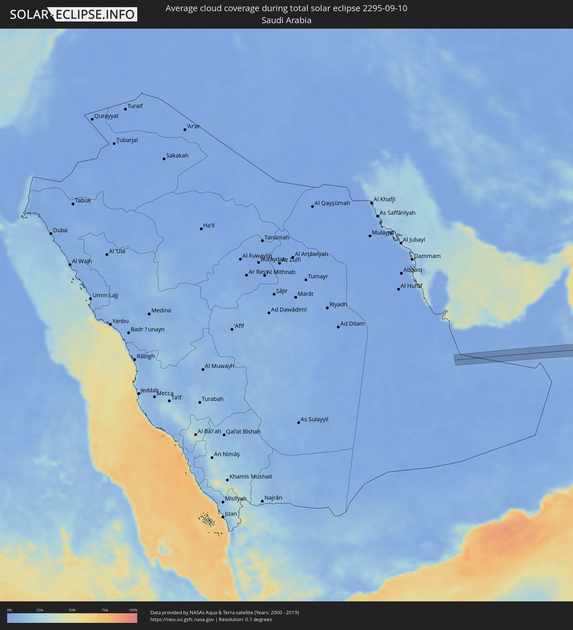 Saudi Arabia
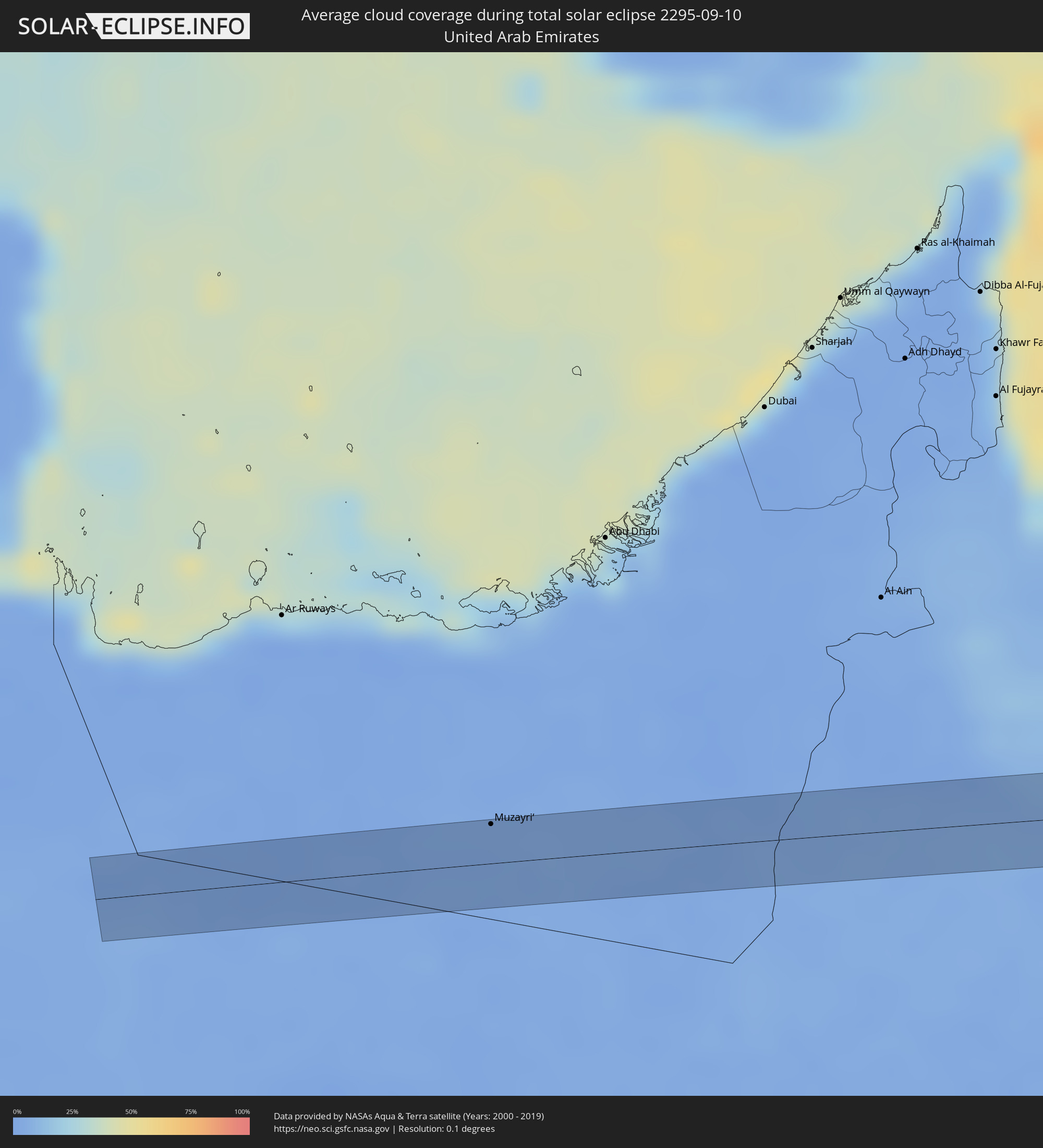 United Arab Emirates
 Oman
Oman
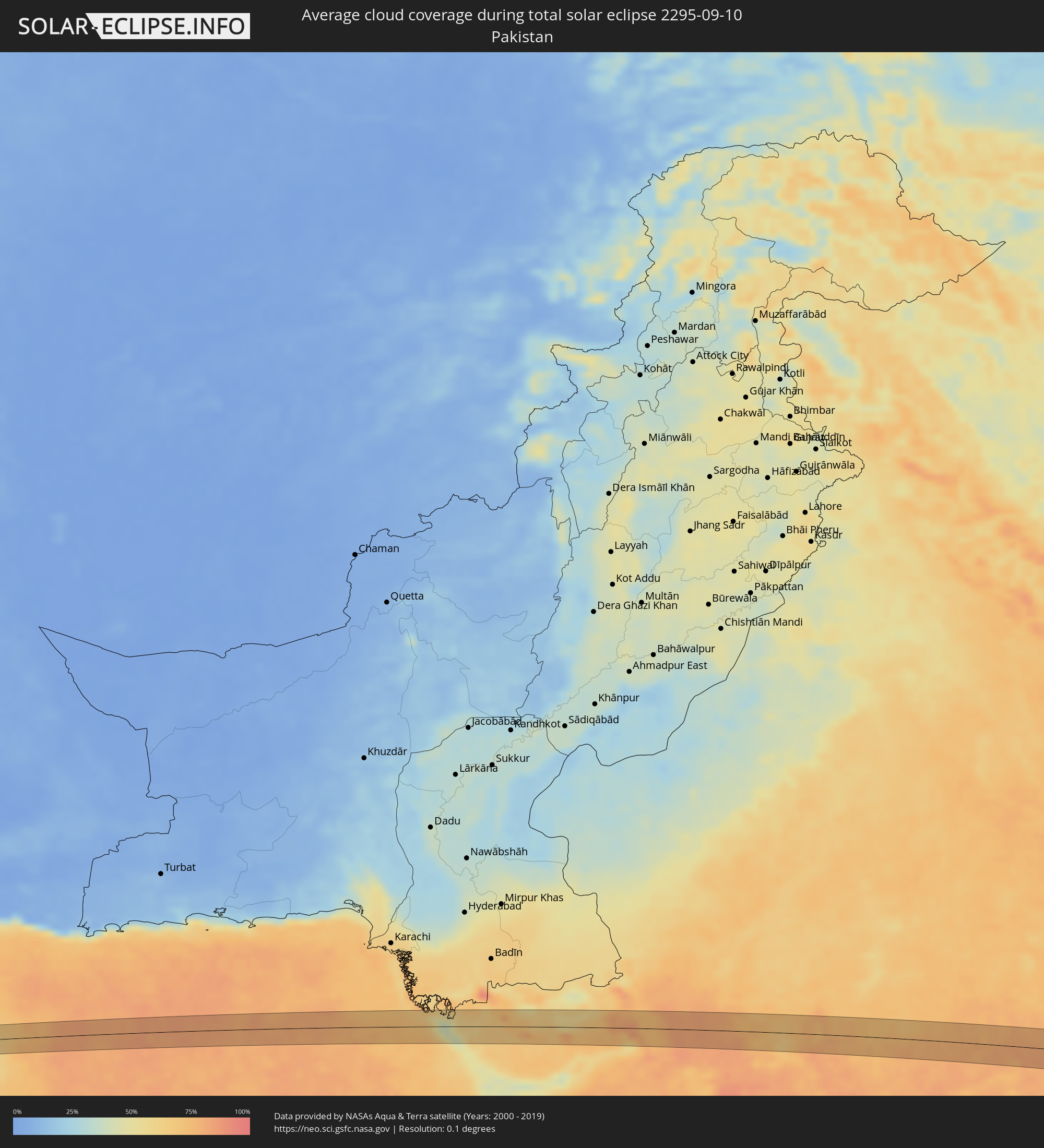 Pakistan
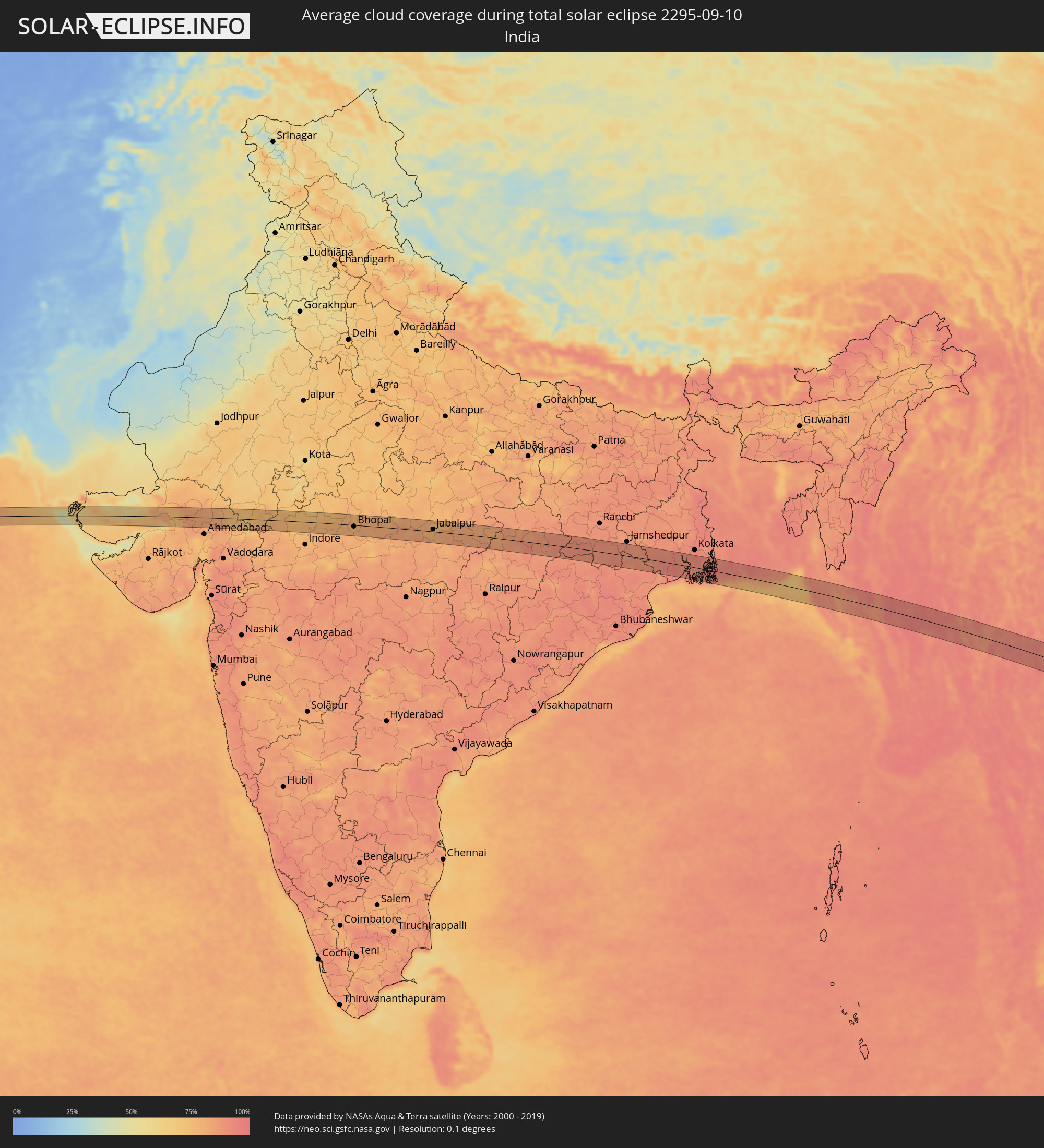 India
India
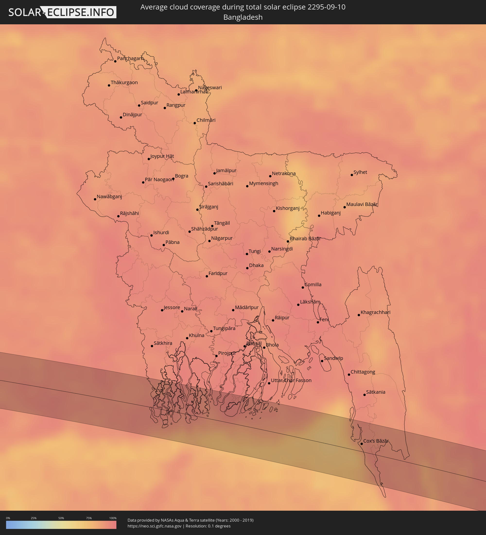 Bangladesh
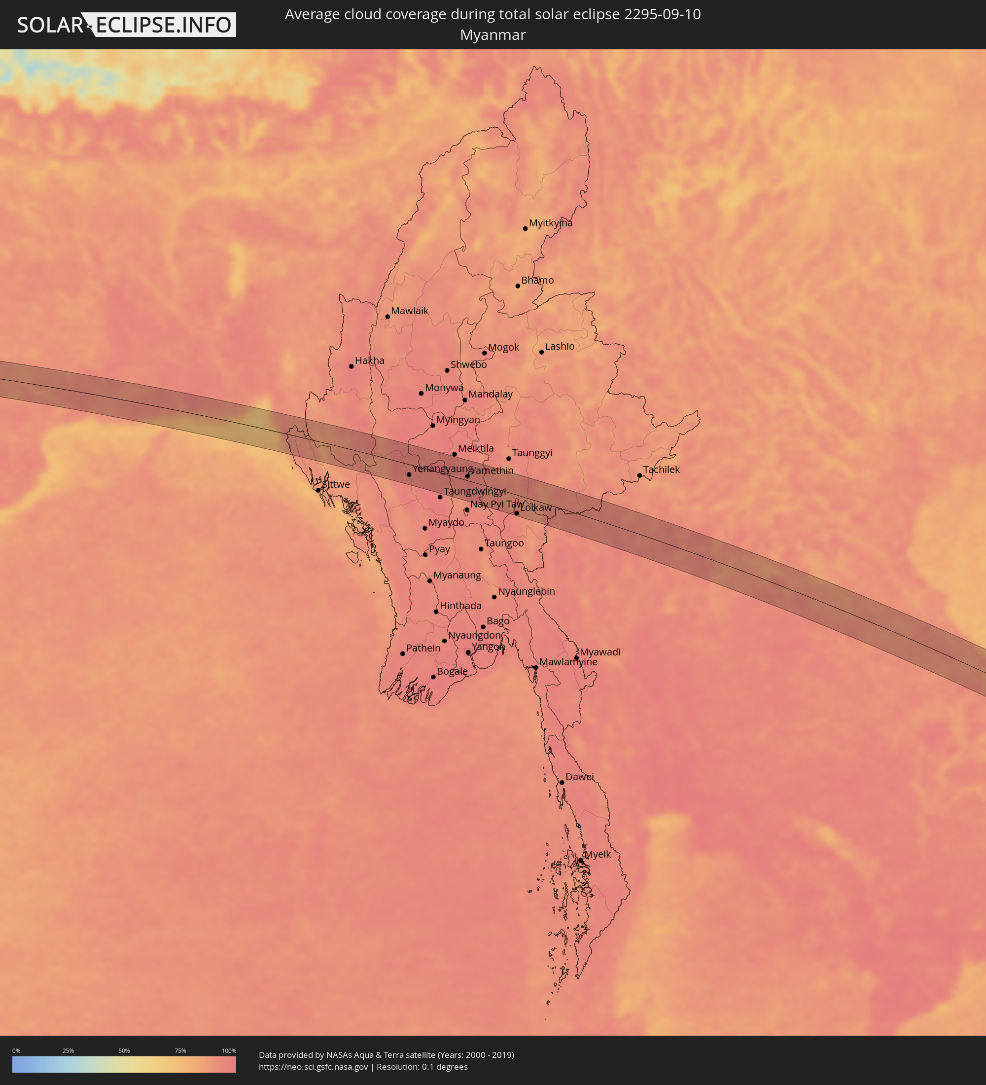 Myanmar
 Indonesia
 Thailand
 Laos
Laos
 Vietnam
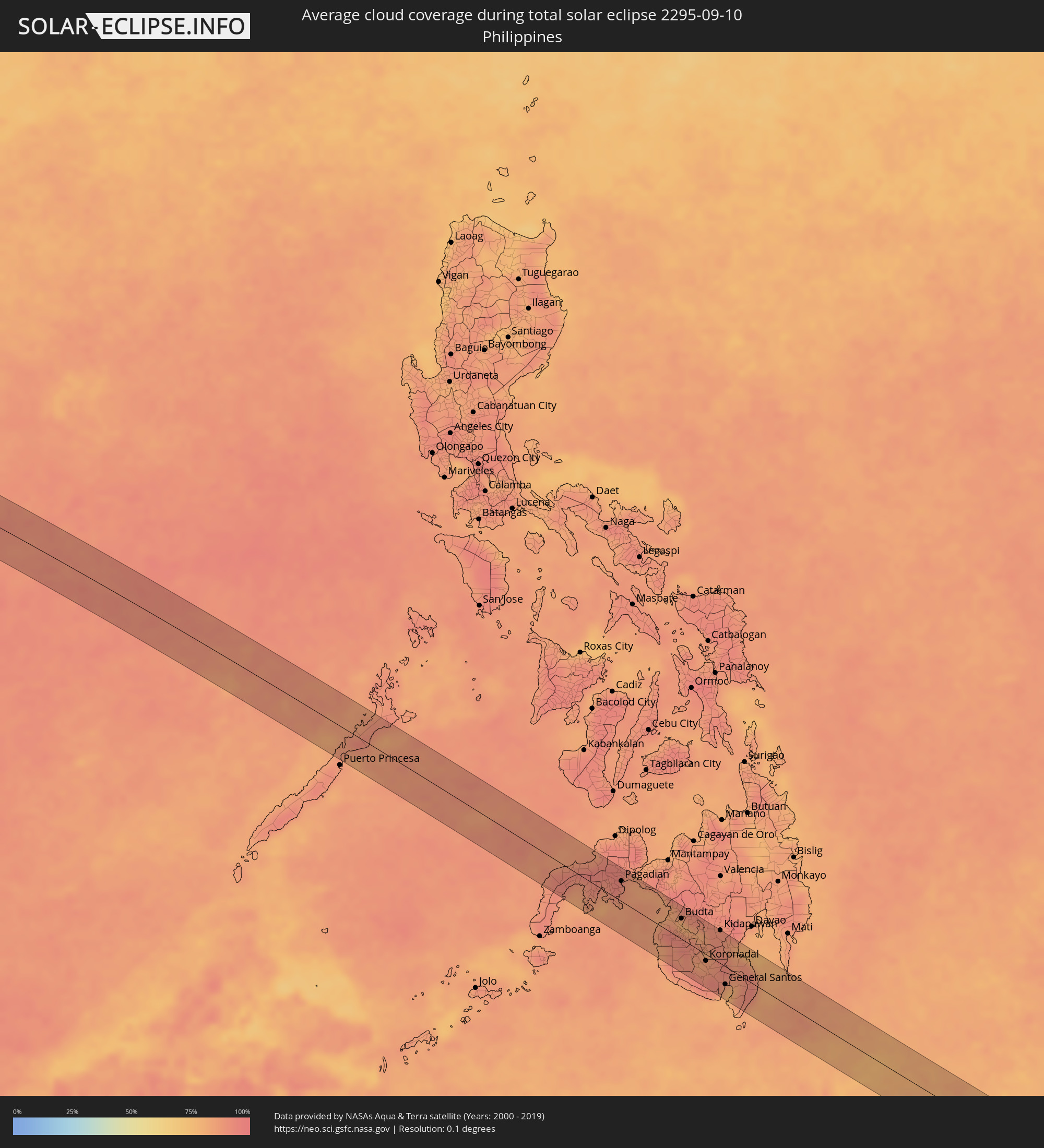 Philippines
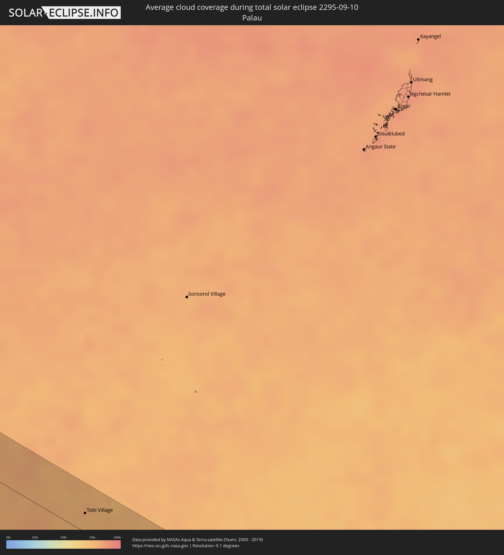 Palau
Palau
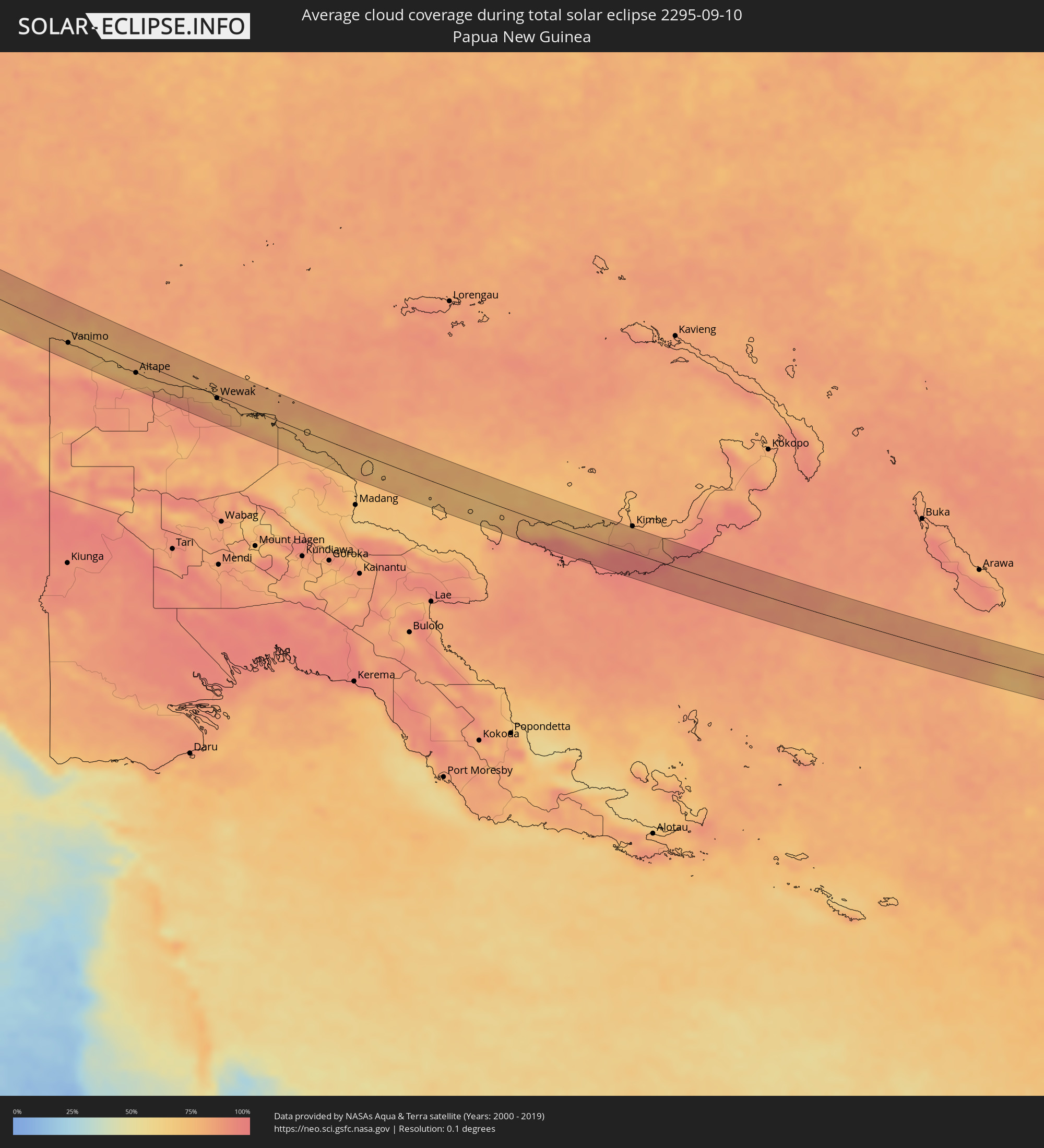 Papua New Guinea
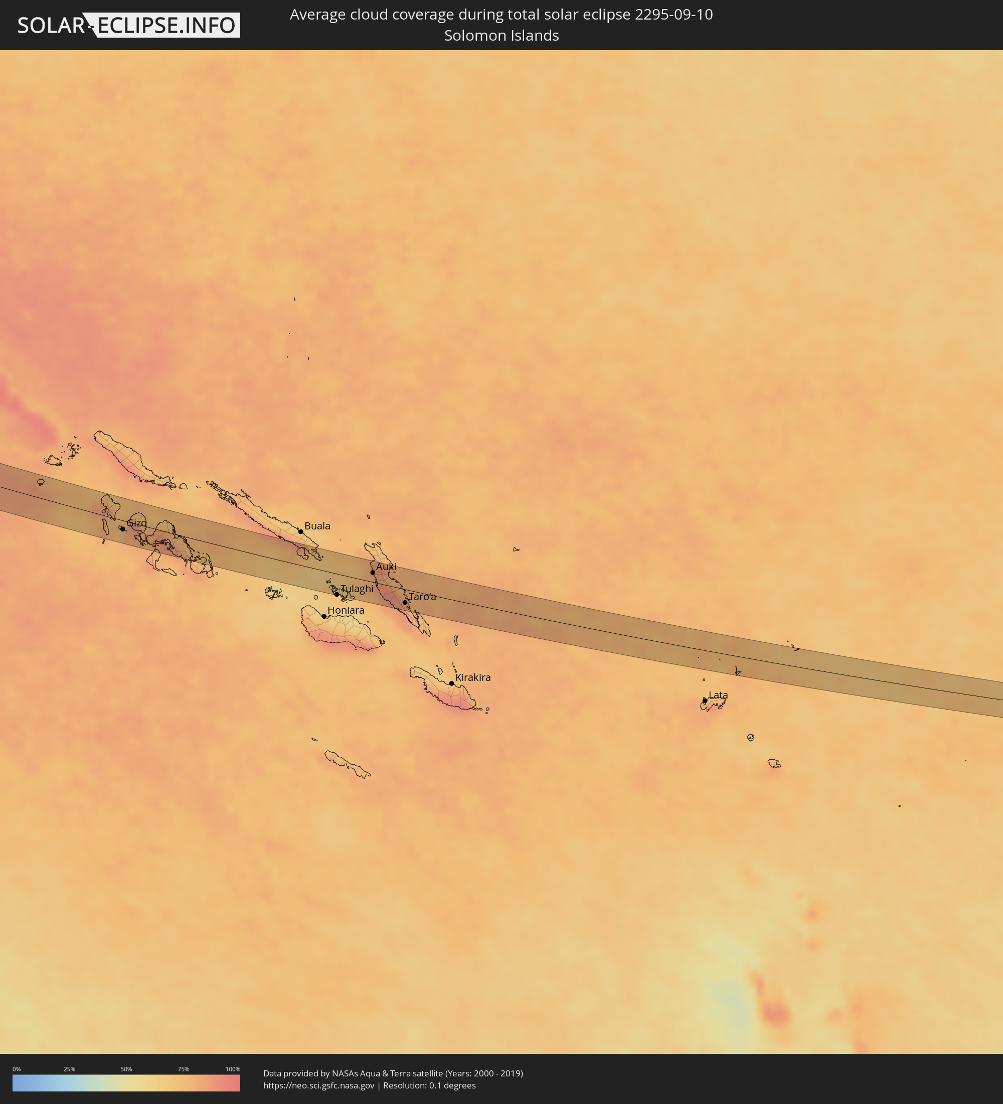 Solomon Islands
Cities inside the path of the eclipse
The following table shows all locations with a population of more than 5,000 inside the eclipse path. Cities which have more than 100,000 inhabitants are marked bold. A click at the locations opens a detailed map.
| City | Type | Eclipse duration | Local time of max. eclipse | Distance to central line | Ø Cloud coverage |
|
Muzayri‘, Abu Dhabi
|
total | - | 06:22:02 UTC+04:00 | 20 km | 2% |
|
‘Ibrī, Az̧ Z̧āhirah
|
total | - | 06:22:16 UTC+04:00 | 7 km | 5% |
|
Rustaq, Al Batinah South Governorate
|
total | - | 06:22:26 UTC+04:00 | 19 km | 11% |
|
Bayt al ‘Awābī, Al Batinah South Governorate
|
total | - | 06:22:26 UTC+04:00 | 9 km | 14% |
|
Sufālat Samā’il, Muḩāfaz̧at ad Dākhilīyah
|
total | - | 06:22:31 UTC+04:00 | 7 km | 9% |
|
Bidbid, Muḩāfaz̧at ad Dākhilīyah
|
total | - | 06:22:33 UTC+04:00 | 16 km | 7% |
|
Visnagar, Gujarat
|
total | - | 07:58:54 UTC+05:30 | 20 km | 82% |
|
Bānswāra, Rajasthan
|
total | - | 08:00:19 UTC+05:30 | 10 km | 77% |
|
Ratlām, Madhya Pradesh
|
total | - | 08:00:47 UTC+05:30 | 11 km | 77% |
|
Nagda, Madhya Pradesh
|
total | - | 08:01:07 UTC+05:30 | 5 km | 74% |
|
Ujjain, Madhya Pradesh
|
total | - | 08:01:24 UTC+05:30 | 23 km | 76% |
|
Sehore, Madhya Pradesh
|
total | - | 08:02:35 UTC+05:30 | 13 km | 79% |
|
Bhopal, Madhya Pradesh
|
total | - | 08:02:53 UTC+05:30 | 5 km | 76% |
|
Vidisha, Madhya Pradesh
|
total | - | 08:03:17 UTC+05:30 | 29 km | 78% |
|
Jabalpur, Madhya Pradesh
|
total | - | 08:05:26 UTC+05:30 | 7 km | 80% |
|
Shahdol, Madhya Pradesh
|
total | - | 08:06:59 UTC+05:30 | 36 km | 81% |
|
Kharagpur, West Bengal
|
total | - | 08:14:44 UTC+05:30 | 14 km | 93% |
|
Contai, West Bengal
|
total | - | 08:15:28 UTC+05:30 | 40 km | 93% |
|
Haldia, West Bengal
|
total | - | 08:15:57 UTC+05:30 | 2 km | 92% |
|
Kultali, West Bengal
|
total | - | 08:16:25 UTC+05:30 | 15 km | 89% |
|
Bārāsat, West Bengal
|
total | - | 08:16:26 UTC+05:30 | 22 km | 91% |
|
Gosāba, West Bengal
|
total | - | 08:16:58 UTC+05:30 | 22 km | 90% |
|
Cox’s Bāzār, Chittagong
|
total | - | 08:52:22 UTC+06:00 | 11 km | 78% |
|
Chauk, Magway
|
total | - | 09:27:36 UTC+06:30 | 22 km | 95% |
|
Yenangyaung, Magway
|
total | - | 09:27:54 UTC+06:30 | 23 km | 93% |
|
Yamethin, Mandalay
|
total | - | 09:30:21 UTC+06:30 | 8 km | 96% |
|
Loikaw, Kayah
|
total | - | 09:32:54 UTC+06:30 | 41 km | 92% |
|
Mae Chai, Phayao
|
total | - | 10:08:33 UTC+07:00 | 7 km | 90% |
|
Phayao, Phayao
|
total | - | 10:08:48 UTC+07:00 | 7 km | 90% |
|
Pa Daet, Chiang Rai
|
total | - | 10:08:49 UTC+07:00 | 30 km | 92% |
|
Dok Kham Tai, Phayao
|
total | - | 10:09:04 UTC+07:00 | 6 km | 91% |
|
Pong, Phayao
|
total | - | 10:09:41 UTC+07:00 | 2 km | 94% |
|
Chiang Kham, Phayao
|
total | - | 10:09:28 UTC+07:00 | 43 km | 94% |
|
Nan, Nan
|
total | - | 10:11:05 UTC+07:00 | 18 km | 92% |
|
Chiang Klang, Nan
|
total | - | 10:10:51 UTC+07:00 | 38 km | 94% |
|
Muang Phôn-Hông, Vientiane Province
|
total | - | 10:14:59 UTC+07:00 | 11 km | 88% |
|
Si Chiang Mai, Nong Khai
|
total | - | 10:15:51 UTC+07:00 | 39 km | 94% |
|
Vientiane, Vientiane
|
total | - | 10:15:53 UTC+07:00 | 37 km | 94% |
|
Nong Khai, Nong Khai
|
total | - | 10:16:17 UTC+07:00 | 41 km | 92% |
|
Phon Charoen, Nong Khai
|
total | - | 10:17:08 UTC+07:00 | 8 km | 92% |
|
Ban Dung, Changwat Udon Thani
|
total | - | 10:17:40 UTC+07:00 | 39 km | 94% |
|
Bueng Kan, Changwat Bueng Kan
|
total | - | 10:17:57 UTC+07:00 | 45 km | 84% |
|
Muang Pakxan, Bolikhamsai Province
|
total | - | 10:17:57 UTC+07:00 | 47 km | 84% |
|
Seka, Changwat Bueng Kan
|
total | - | 10:19:05 UTC+07:00 | 12 km | 88% |
|
Na Wa, Nakhon Phanom
|
total | - | 10:19:51 UTC+07:00 | 28 km | 92% |
|
Nakhon Phanom, Nakhon Phanom
|
total | - | 10:21:33 UTC+07:00 | 8 km | 88% |
|
Thakhèk, Khammouan
|
total | - | 10:21:40 UTC+07:00 | 6 km | 88% |
|
Ðông Hà, Quảng Trị
|
total | - | 10:27:52 UTC+07:00 | 30 km | 87% |
|
Huế, Thừa Thiên-Huế
|
total | - | 10:29:31 UTC+07:00 | 16 km | 88% |
|
Da Nang, Đà Nẵng
|
total | - | 10:31:34 UTC+07:00 | 5 km | 88% |
|
Hội An, Quảng Nam
|
total | - | 10:32:05 UTC+07:00 | 9 km | 85% |
|
Tam Kỳ, Quảng Nam
|
total | - | 10:32:49 UTC+07:00 | 33 km | 84% |
|
Pagadian, Zamboanga Peninsula
|
total | - | 12:25:06 UTC+08:00 | 32 km | 92% |
|
Cotabato, Autonomous Region in Muslim Mindanao
|
total | - | 12:28:16 UTC+08:00 | 23 km | 86% |
|
Parang, Autonomous Region in Muslim Mindanao
|
total | - | 12:28:04 UTC+08:00 | 38 km | 84% |
|
Budta, Autonomous Region in Muslim Mindanao
|
total | - | 12:28:48 UTC+08:00 | 32 km | 78% |
|
Tacurong, Soccsksargen
|
total | - | 12:30:18 UTC+08:00 | 2 km | 87% |
|
Sebu, Soccsksargen
|
total | - | 12:31:09 UTC+08:00 | 46 km | 94% |
|
Surallah, Soccsksargen
|
total | - | 12:31:01 UTC+08:00 | 28 km | 87% |
|
Kabacan, Soccsksargen
|
total | - | 12:29:59 UTC+08:00 | 46 km | 88% |
|
Koronadal, Soccsksargen
|
total | - | 12:31:04 UTC+08:00 | 10 km | 85% |
|
Polomolok, Davao
|
total | - | 12:32:06 UTC+08:00 | 24 km | 89% |
|
Kidapawan, Soccsksargen
|
total | - | 12:30:49 UTC+08:00 | 52 km | 90% |
|
General Santos, Soccsksargen
|
total | - | 12:32:34 UTC+08:00 | 28 km | 79% |
|
Bansalan, Davao
|
total | - | 12:31:31 UTC+08:00 | 38 km | 87% |
|
Maluñgun, Soccsksargen
|
total | - | 12:32:34 UTC+08:00 | 6 km | 88% |
|
Digos, Davao
|
total | - | 12:31:57 UTC+08:00 | 43 km | 78% |
|
Malita, Davao
|
total | - | 12:33:11 UTC+08:00 | 27 km | 86% |
|
Tobi Village, Hatohobei
|
total | - | 13:52:20 UTC+09:00 | 20 km | 77% |
|
Abepura, Papua
|
total | - | 14:19:33 UTC+09:00 | 41 km | 78% |
|
Jayapura, Papua
|
total | - | 14:19:37 UTC+09:00 | 31 km | 82% |
|
Vanimo, Sandaun
|
total | - | 15:20:43 UTC+10:00 | 19 km | 79% |
|
Vanimo, Sandaun
|
total | - | 15:20:48 UTC+10:00 | 19 km | 79% |
|
Aitape, Sandaun
|
total | - | 15:23:07 UTC+10:00 | 19 km | 77% |
|
Wewak, East Sepik
|
total | - | 15:25:35 UTC+10:00 | 4 km | 79% |
|
Gizo, Western Province
|
total | - | 16:45:13 UTC+11:00 | 15 km | 76% |
|
Tulaghi, Central Province
|
total | - | 16:48:19 UTC+11:00 | 35 km | 69% |
|
Auki, Malaita
|
total | - | 16:48:31 UTC+11:00 | 15 km | 79% |
|
Taro’a, Choiseul
|
total | - | 16:49:05 UTC+11:00 | 23 km | 85% |