Total solar eclipse of 05/12/2469
| Day of week: | Sunday |
| Maximum duration of eclipse: | 03m36s |
| Maximum width of eclipse path: | 172 km |
| Saros cycle: | 155 |
| Coverage: | 100% |
| Magnitude: | 1.0466 |
| Gamma: | 0.4417 |
Wo kann man die Sonnenfinsternis vom 05/12/2469 sehen?
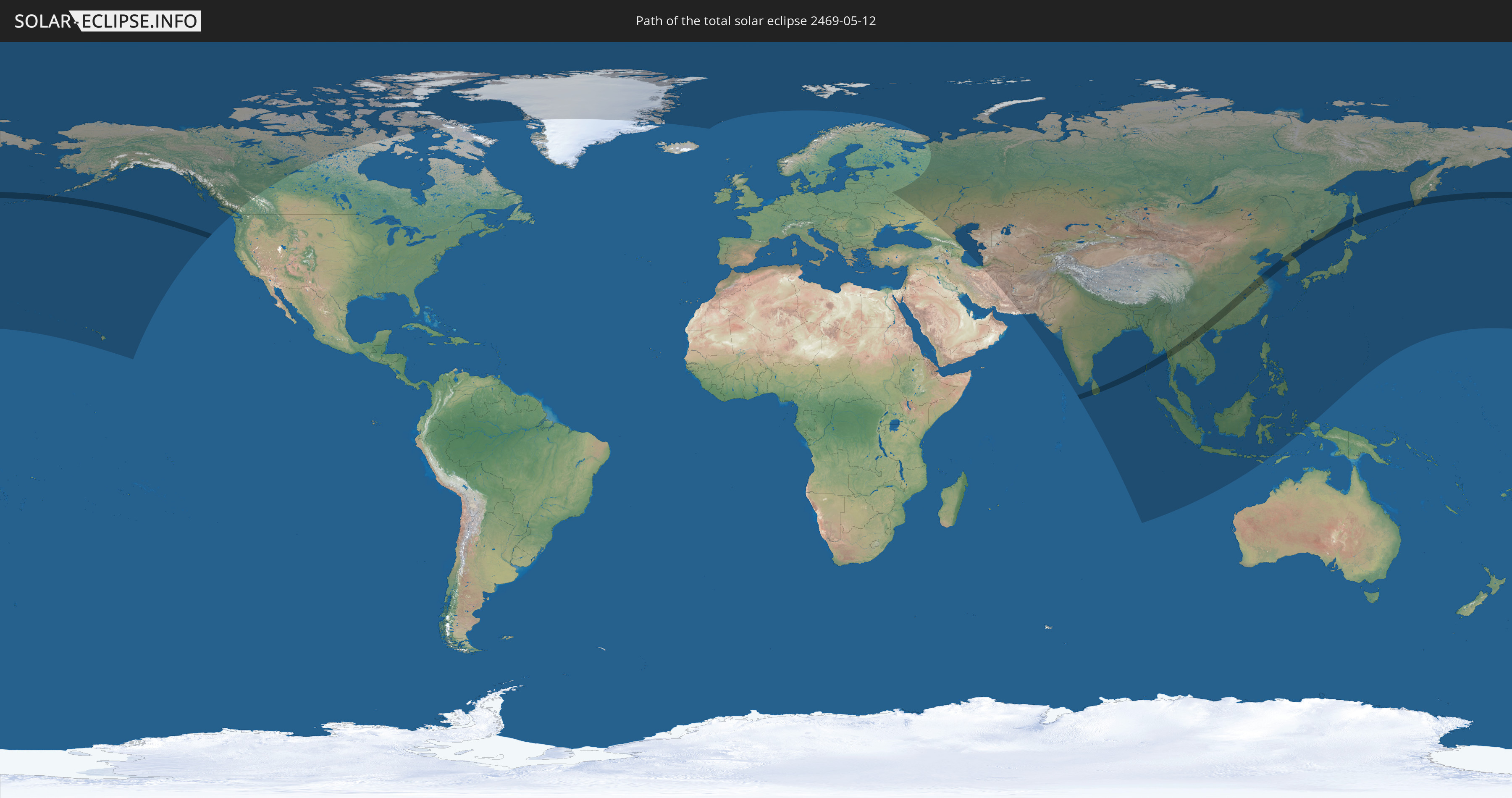
Die Sonnenfinsternis am 05/12/2469 kann man in 45 Ländern als partielle Sonnenfinsternis beobachten.
Der Finsternispfad verläuft durch 11 Länder. Nur in diesen Ländern ist sie als total Sonnenfinsternis zu sehen.
In den folgenden Ländern ist die Sonnenfinsternis total zu sehen
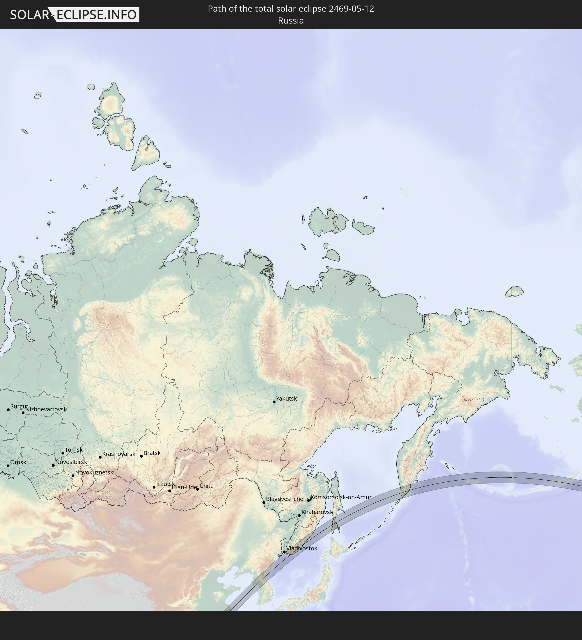 Russia
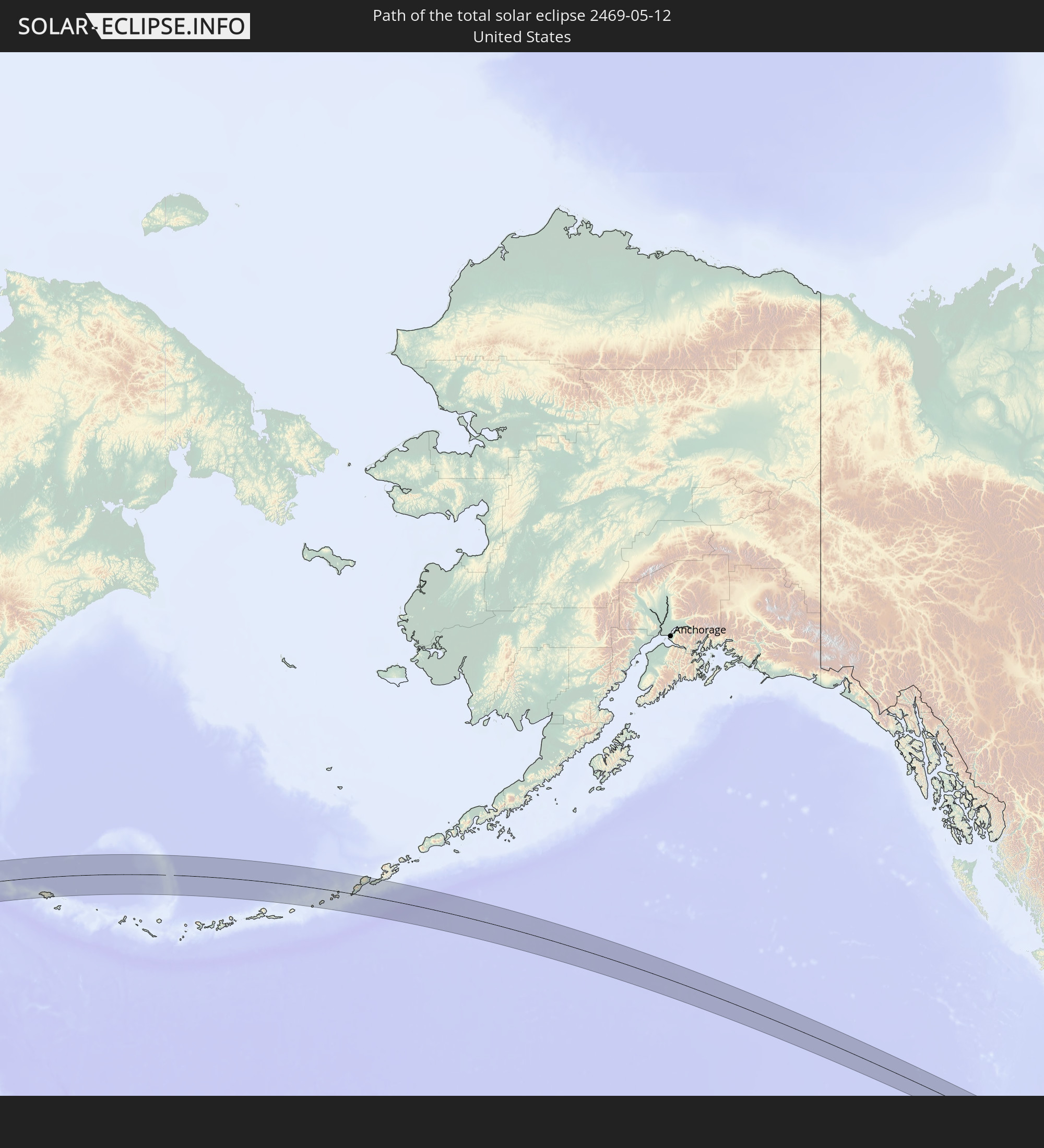 United States
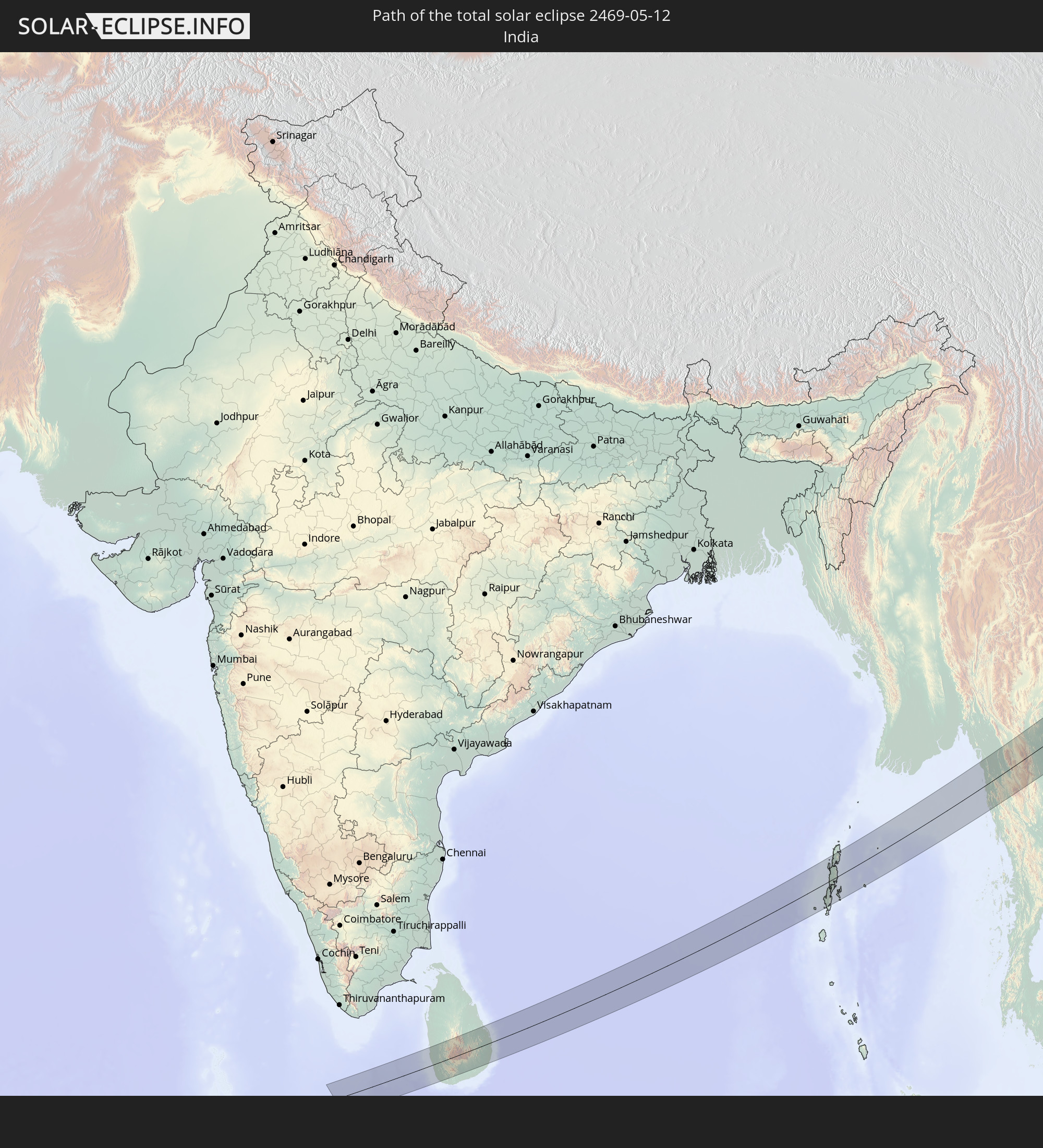 India
India
 China
China
 Sri Lanka
 Myanmar
 Thailand
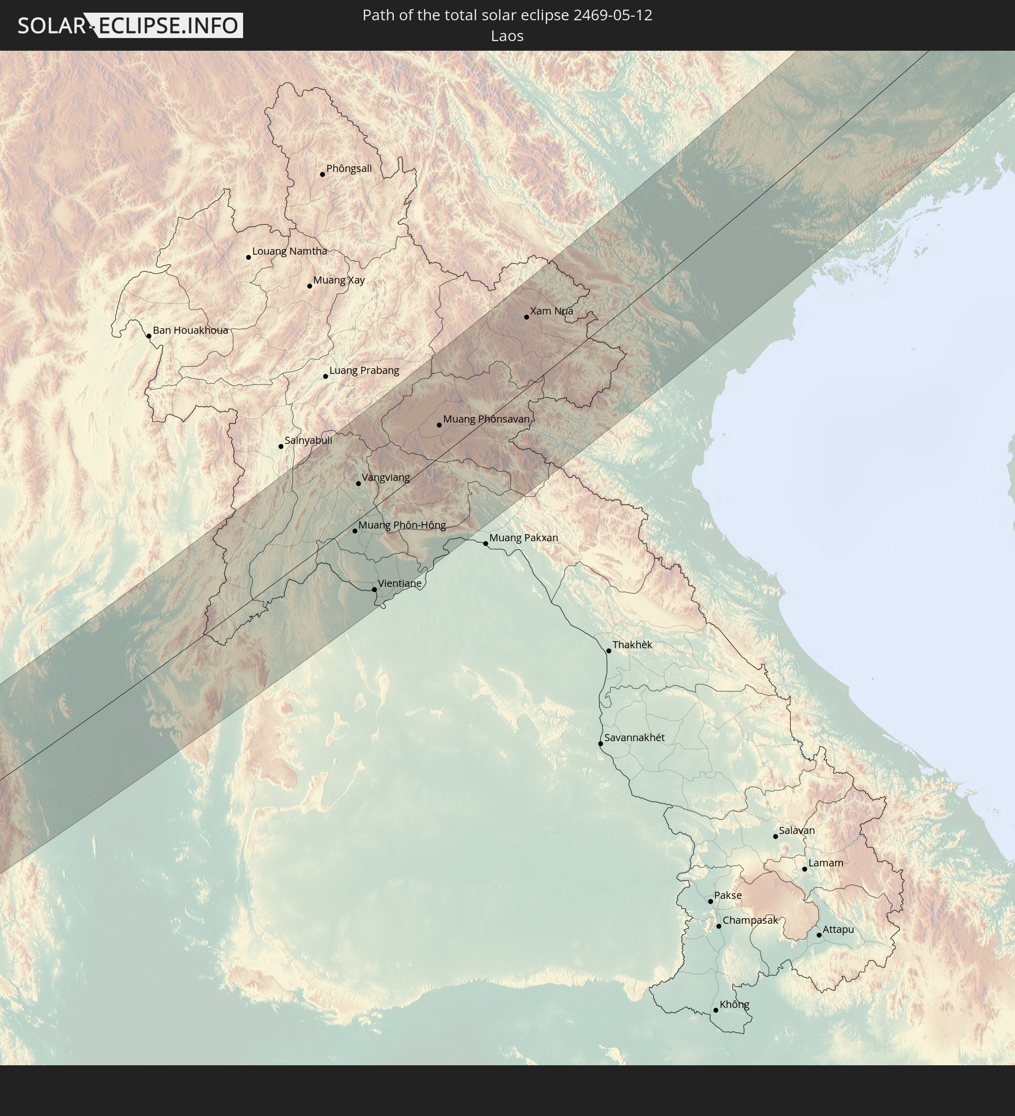 Laos
Laos
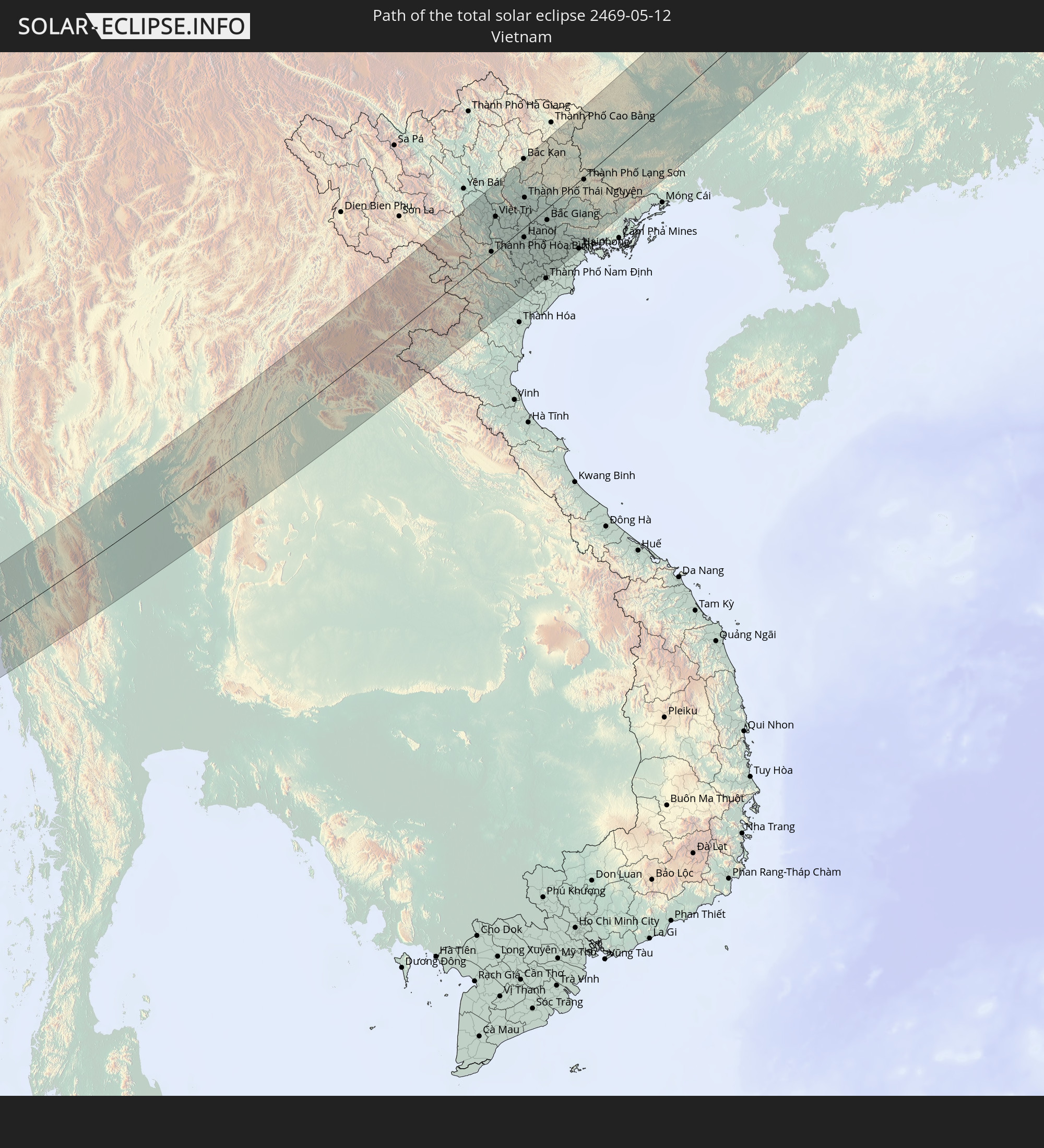 Vietnam
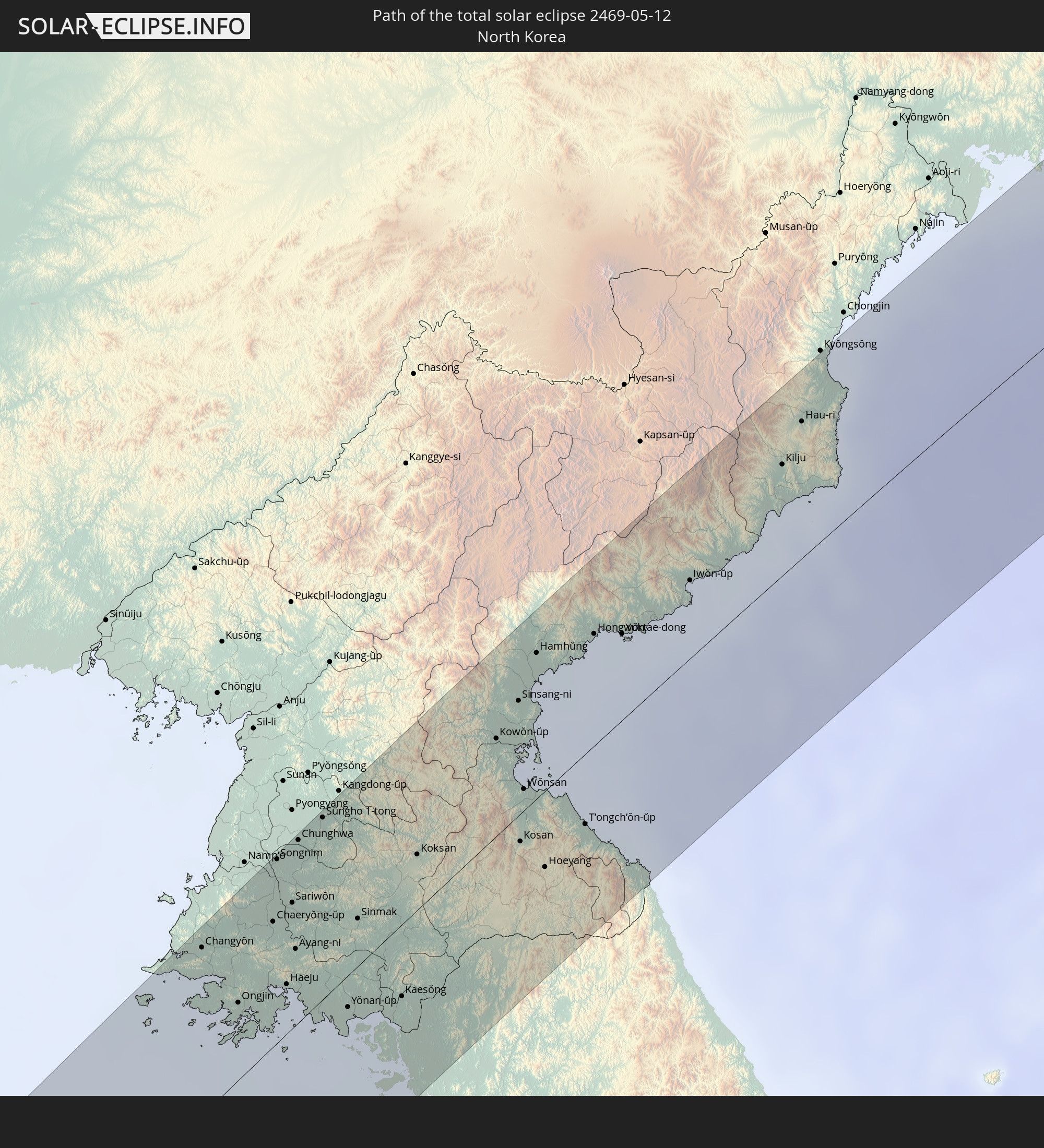 North Korea
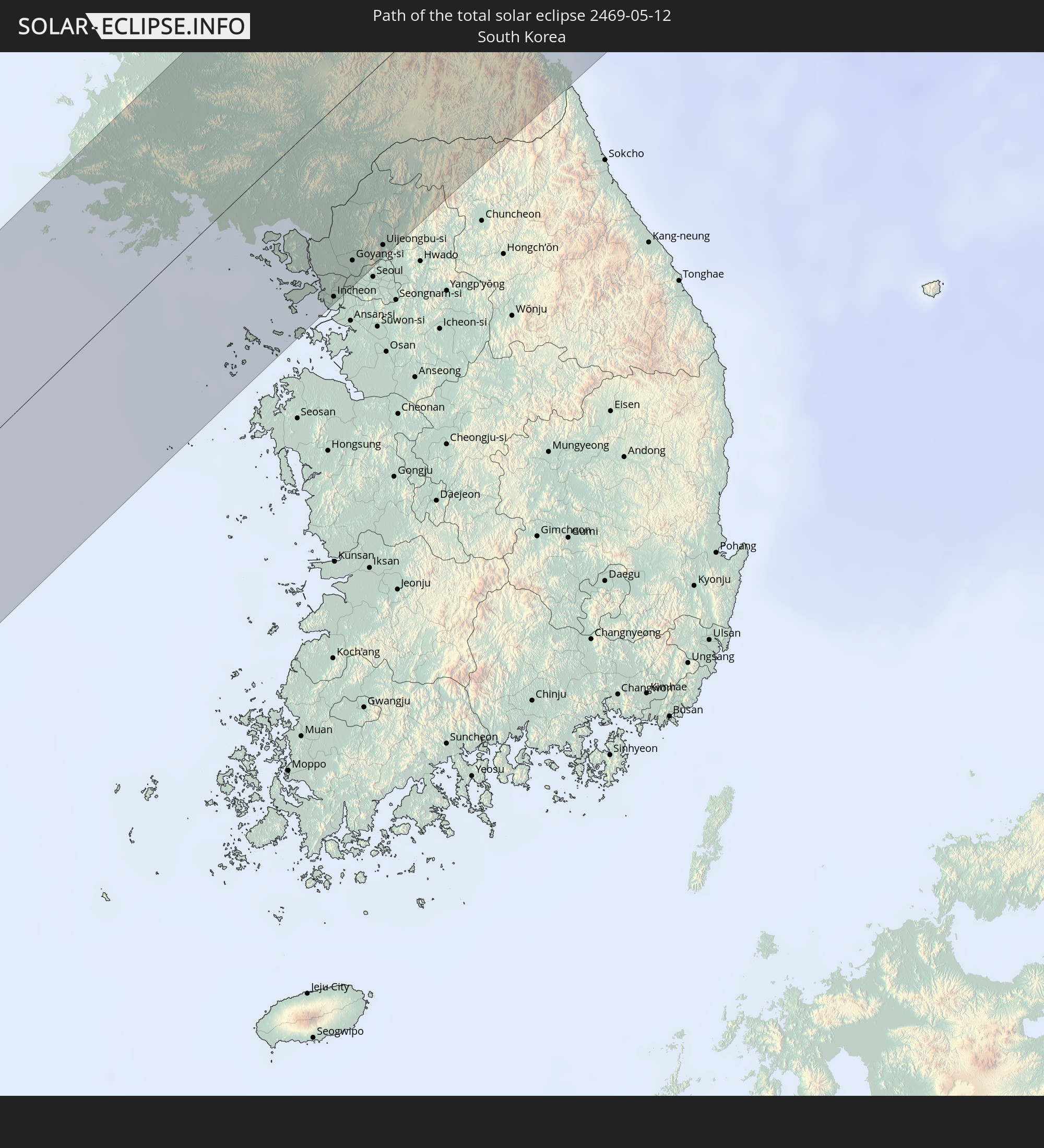 South Korea
In den folgenden Ländern ist die Sonnenfinsternis partiell zu sehen
 Russia
 United States
 United States Minor Outlying Islands
 Canada
 Greenland
 Svalbard and Jan Mayen
 Ukraine
 Iran
Iran
 Azerbaijan
 Kazakhstan
 Turkmenistan
 Uzbekistan
 Afghanistan
 Pakistan
 Tajikistan
 India
India
 Kyrgyzstan
 China
China
 Sri Lanka
 Nepal
Nepal
 Mongolia
 Bangladesh
 Bhutan
 Myanmar
 Indonesia
 Cocos Islands
 Thailand
 Malaysia
 Laos
Laos
 Vietnam
 Cambodia
 Singapore
 Christmas Island
 Macau
Macau
 Hong Kong
 Brunei
 Taiwan
 Philippines
 Japan
Japan
 North Korea
 South Korea
 Palau
Palau
 Federated States of Micronesia
 Guam
Guam
 Northern Mariana Islands
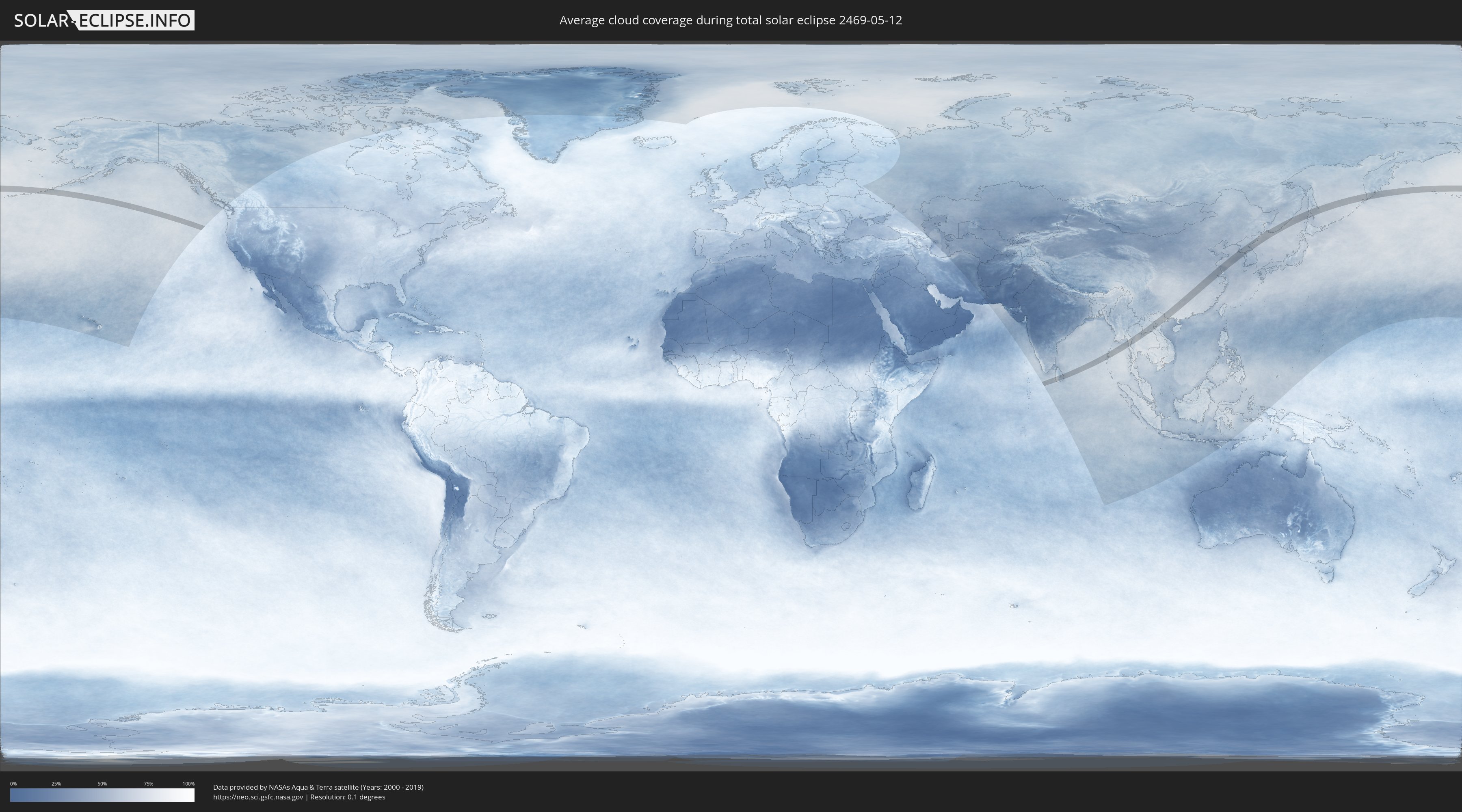
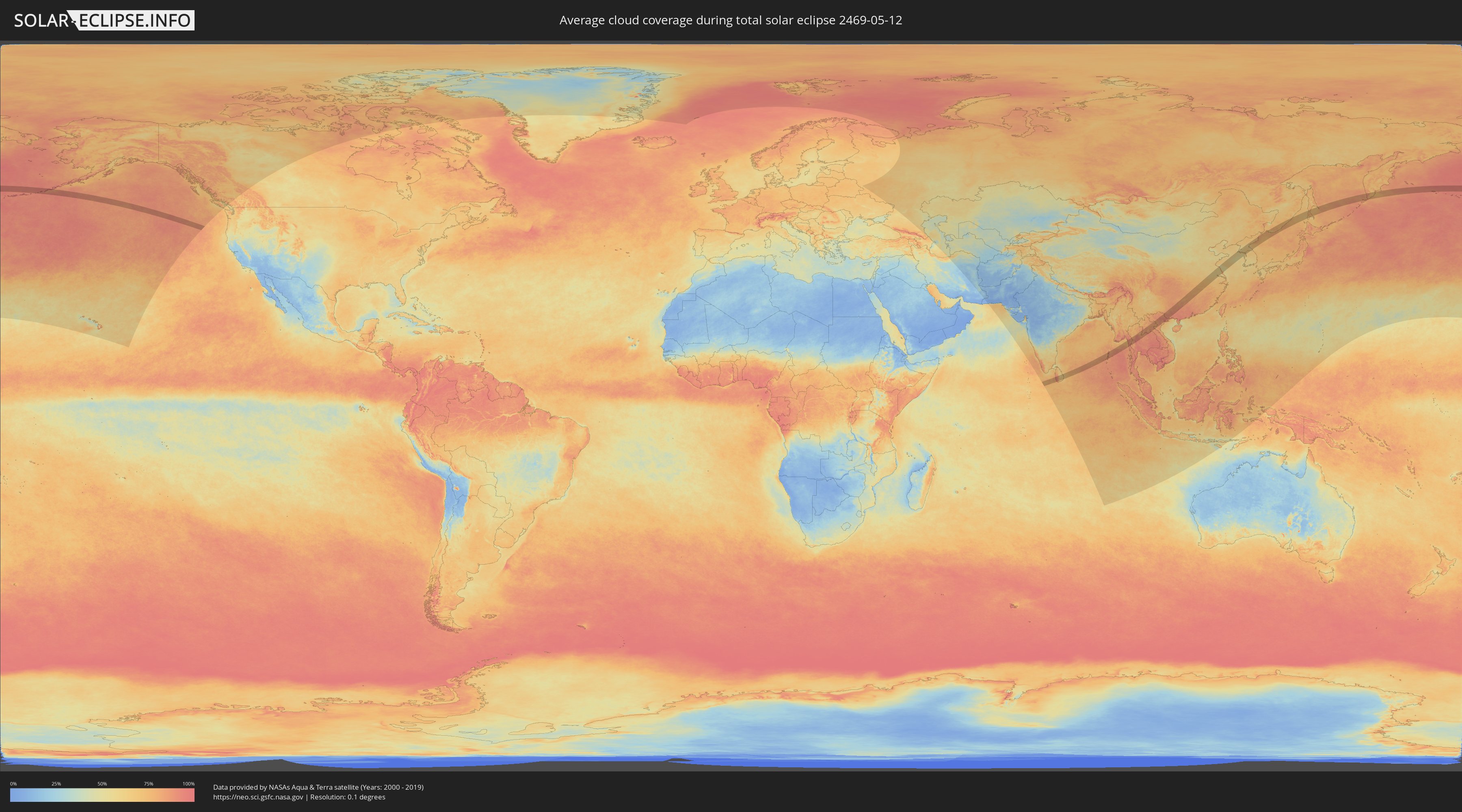
How will be the weather during the total solar eclipse on 05/12/2469?
Where is the best place to see the total solar eclipse of 05/12/2469?
The following maps show the average cloud coverage for the day of the total solar eclipse.
With the help of these maps, it is possible to find the place along the eclipse path, which has the best
chance of a cloudless sky.
Nevertheless, you should consider local circumstances and inform about the weather of your chosen
observation site.
The data is provided by NASAs satellites
AQUA and TERRA.
The cloud maps are averaged over a period of 19 years (2000 - 2019).
Detailed country maps
 Russia
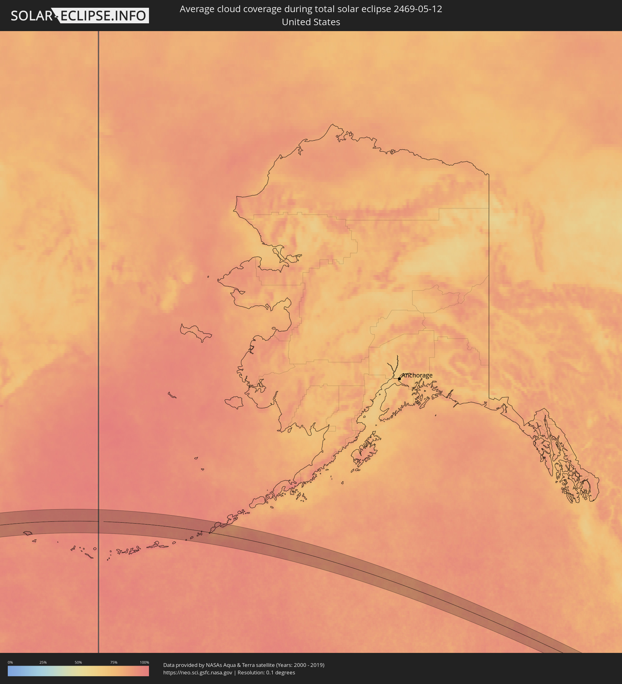 United States
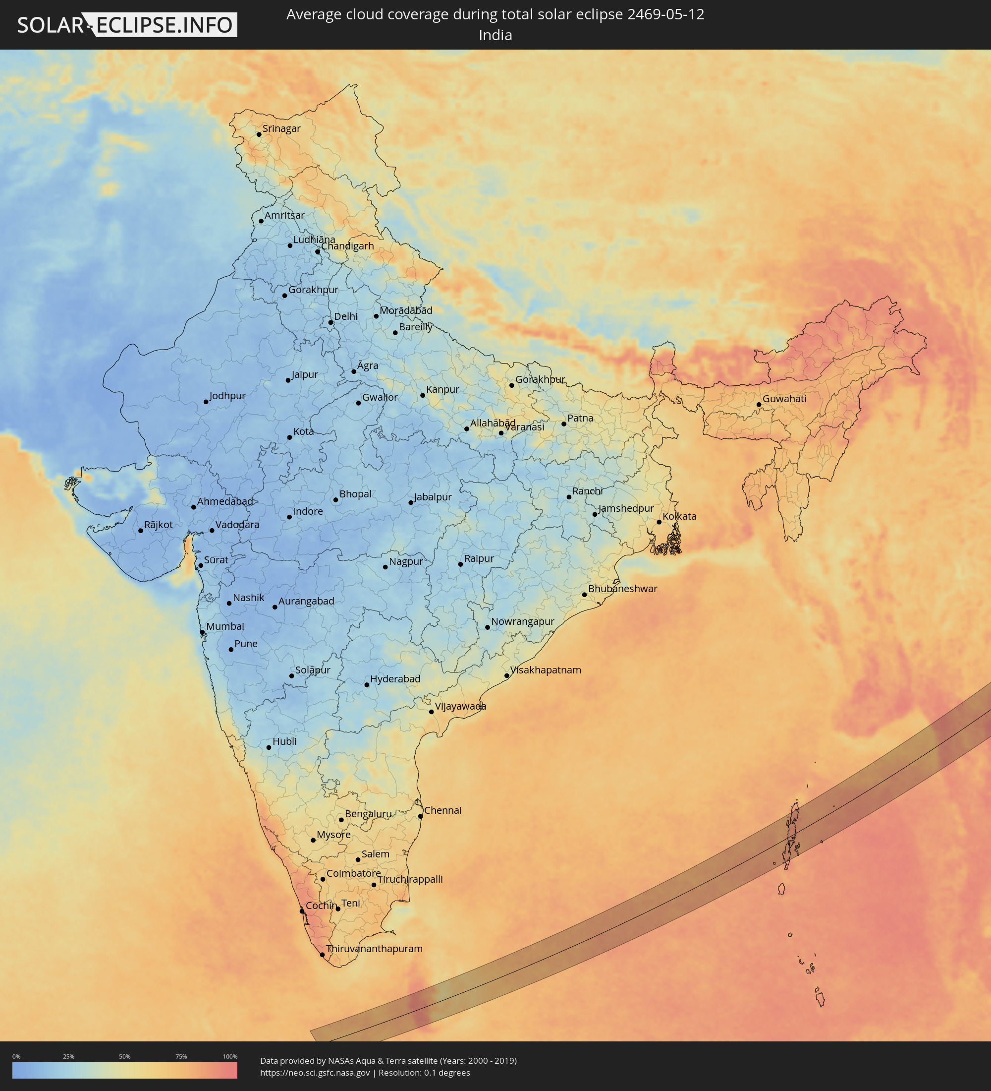 India
India
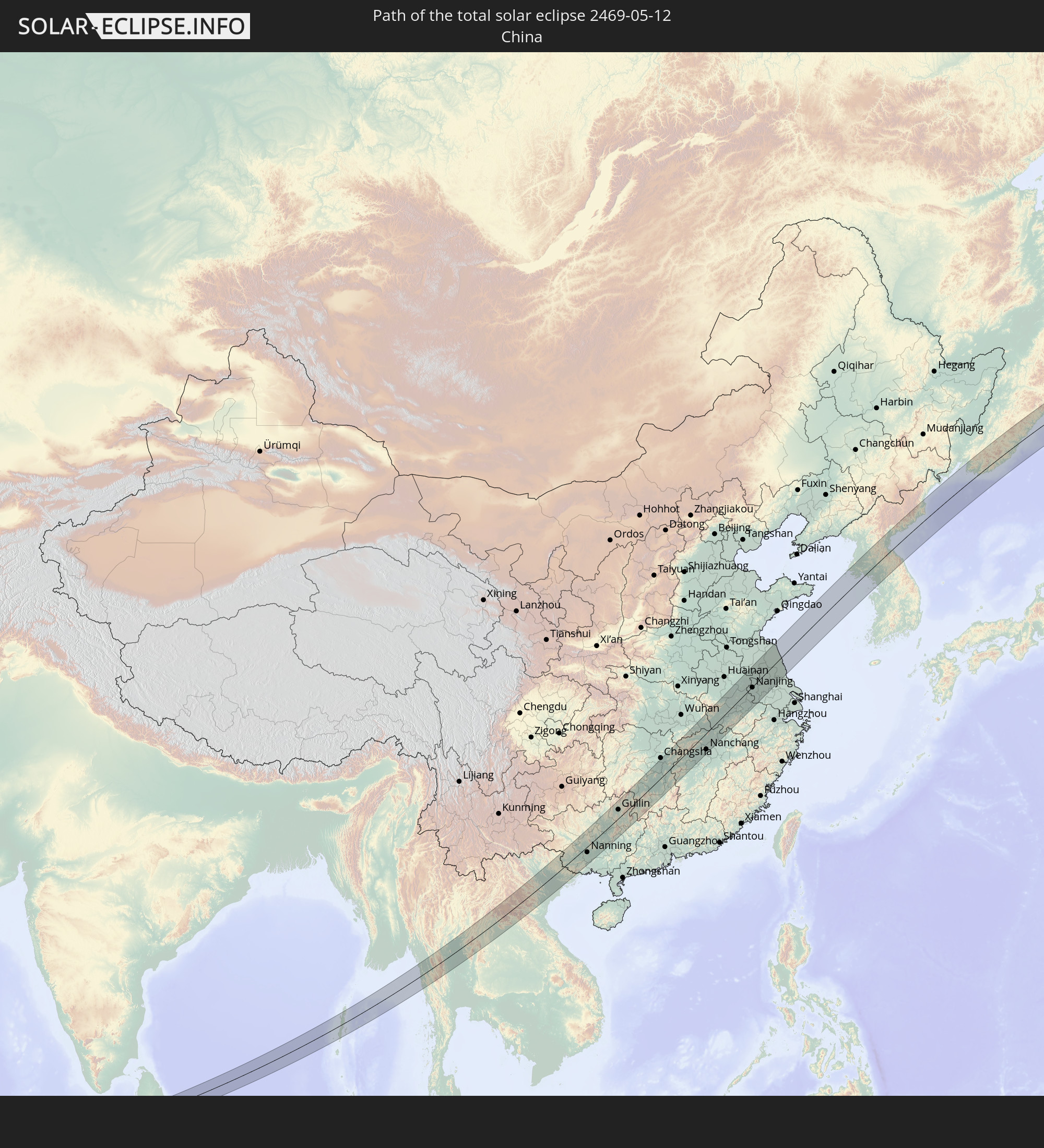
 China
China
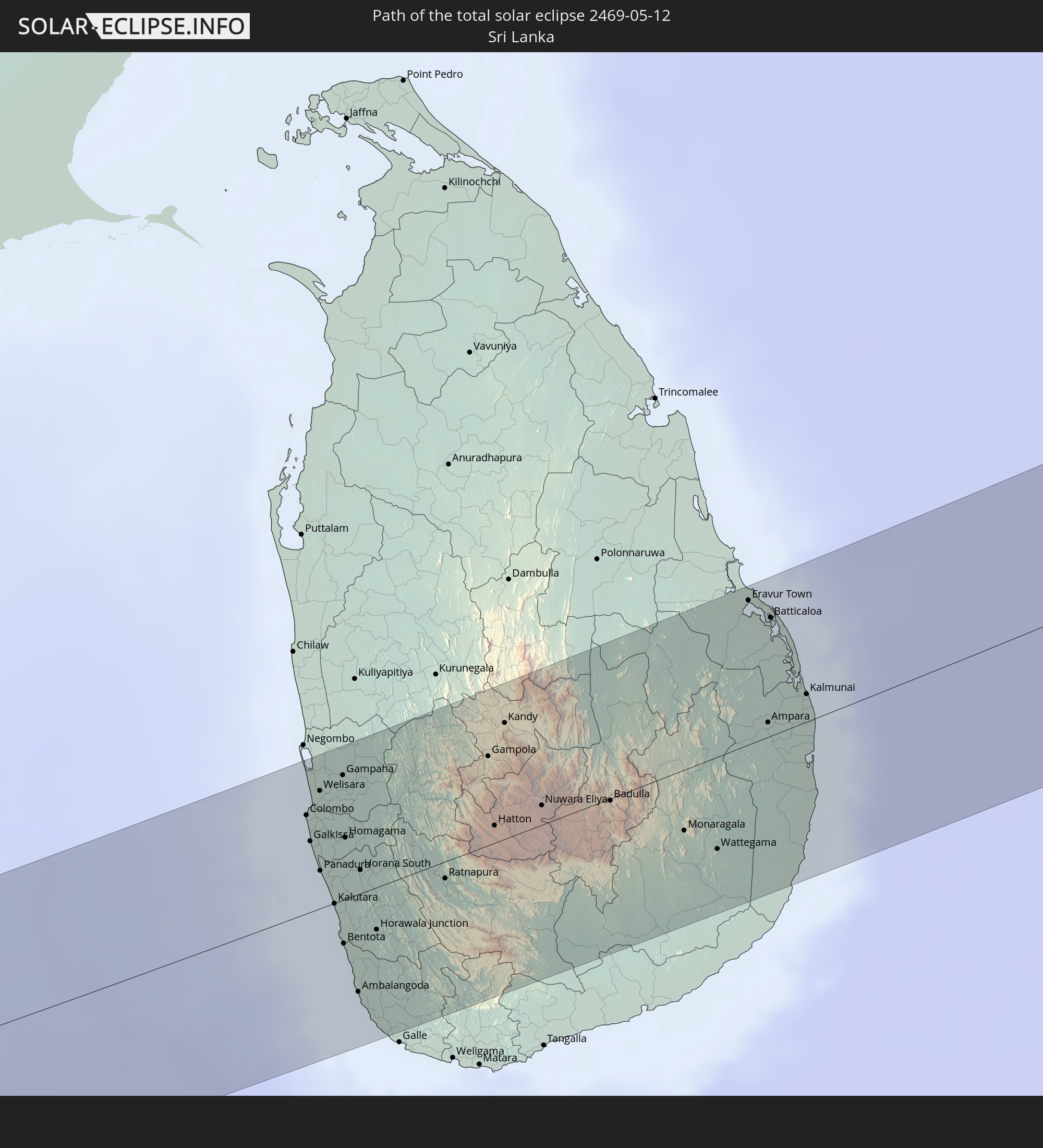
 Sri Lanka
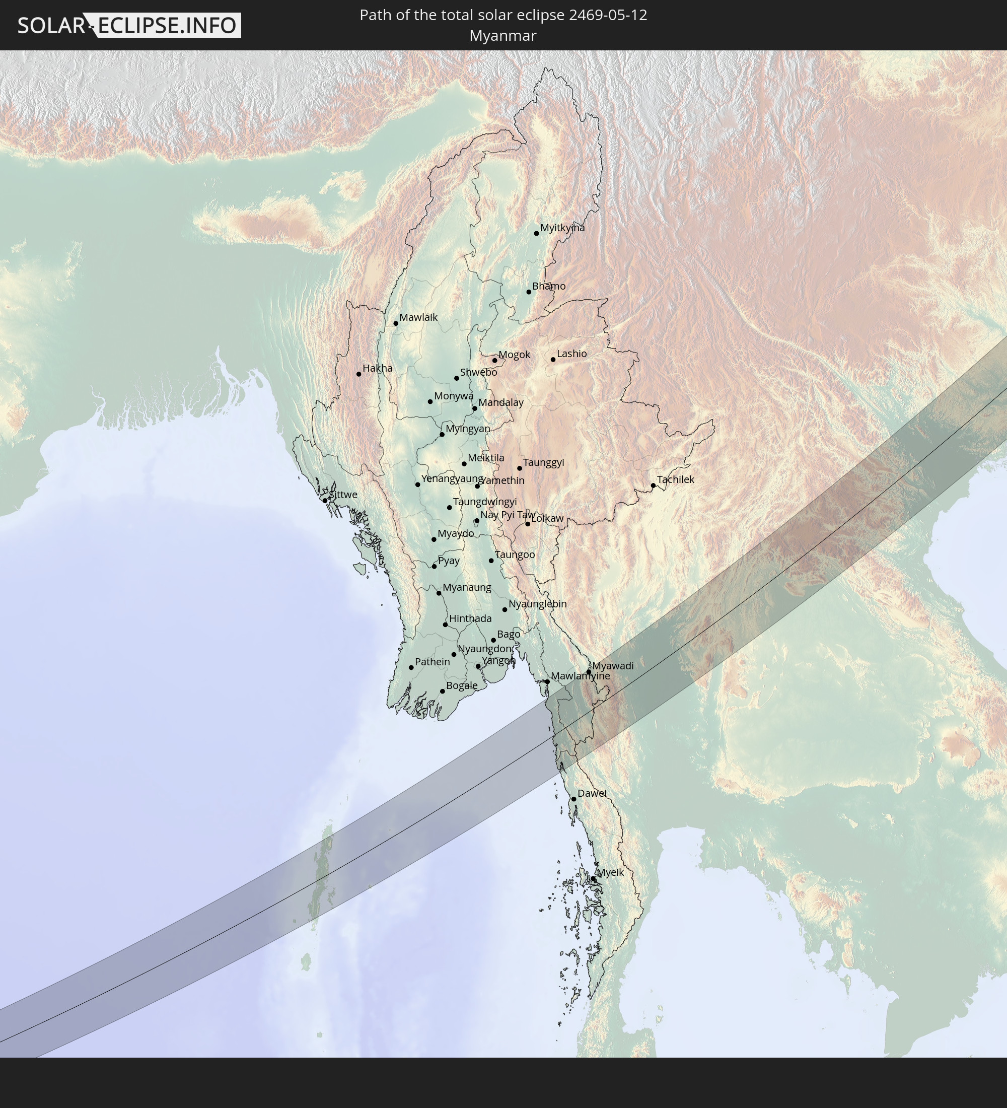
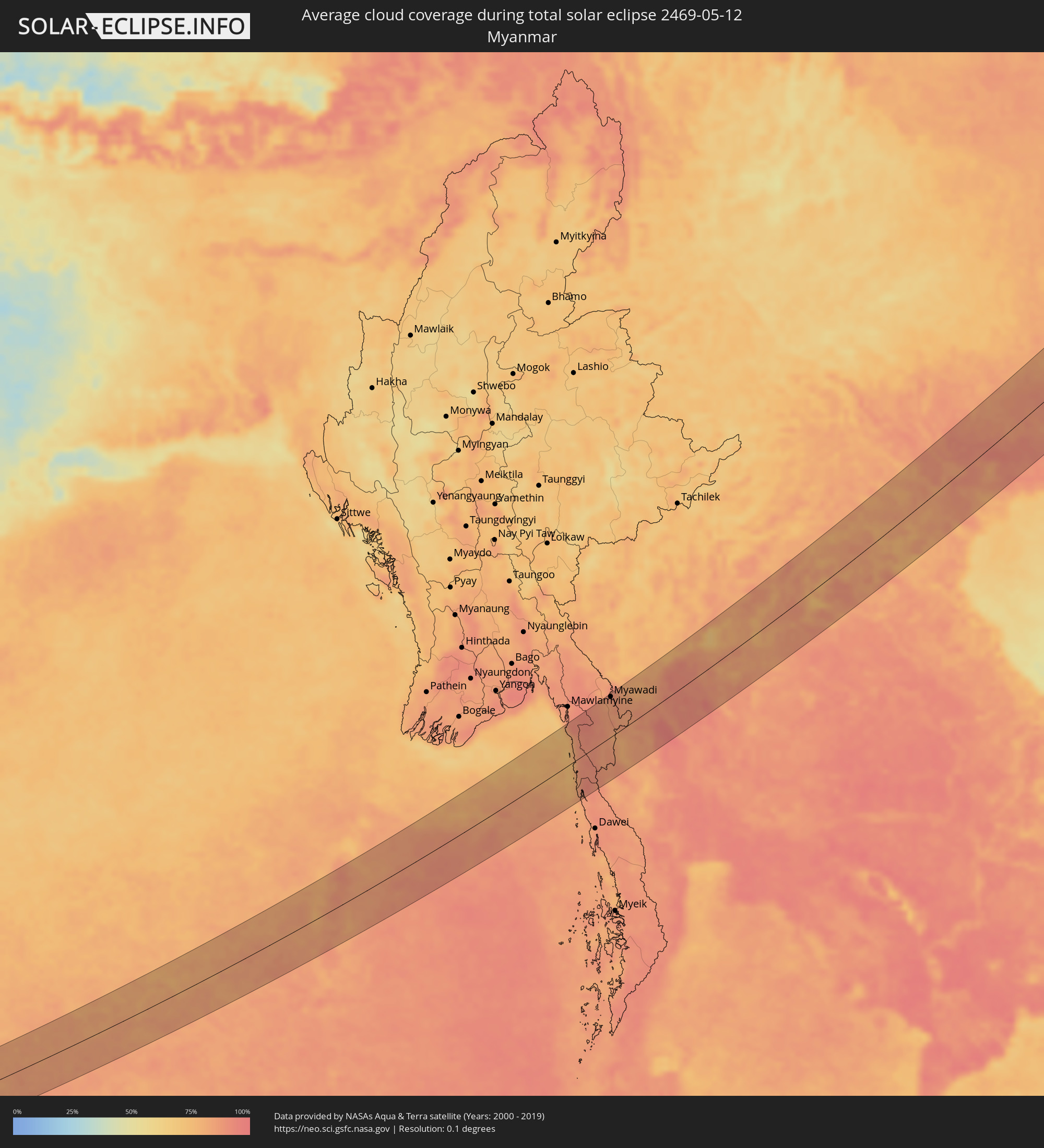 Myanmar
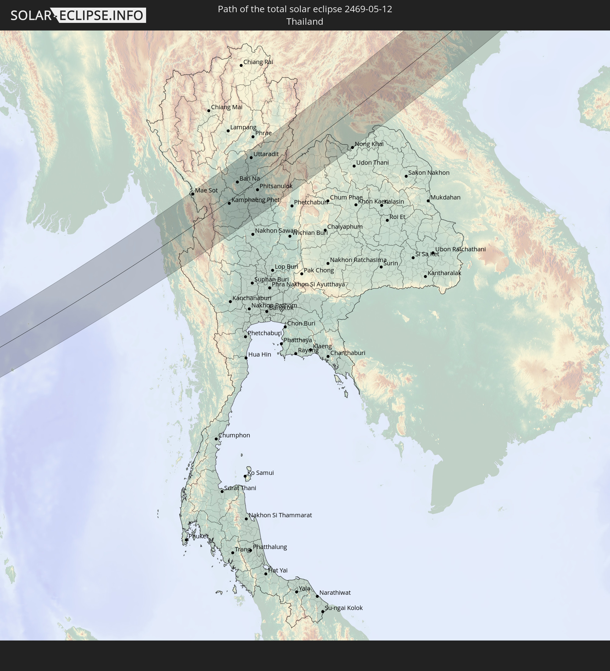
 Thailand
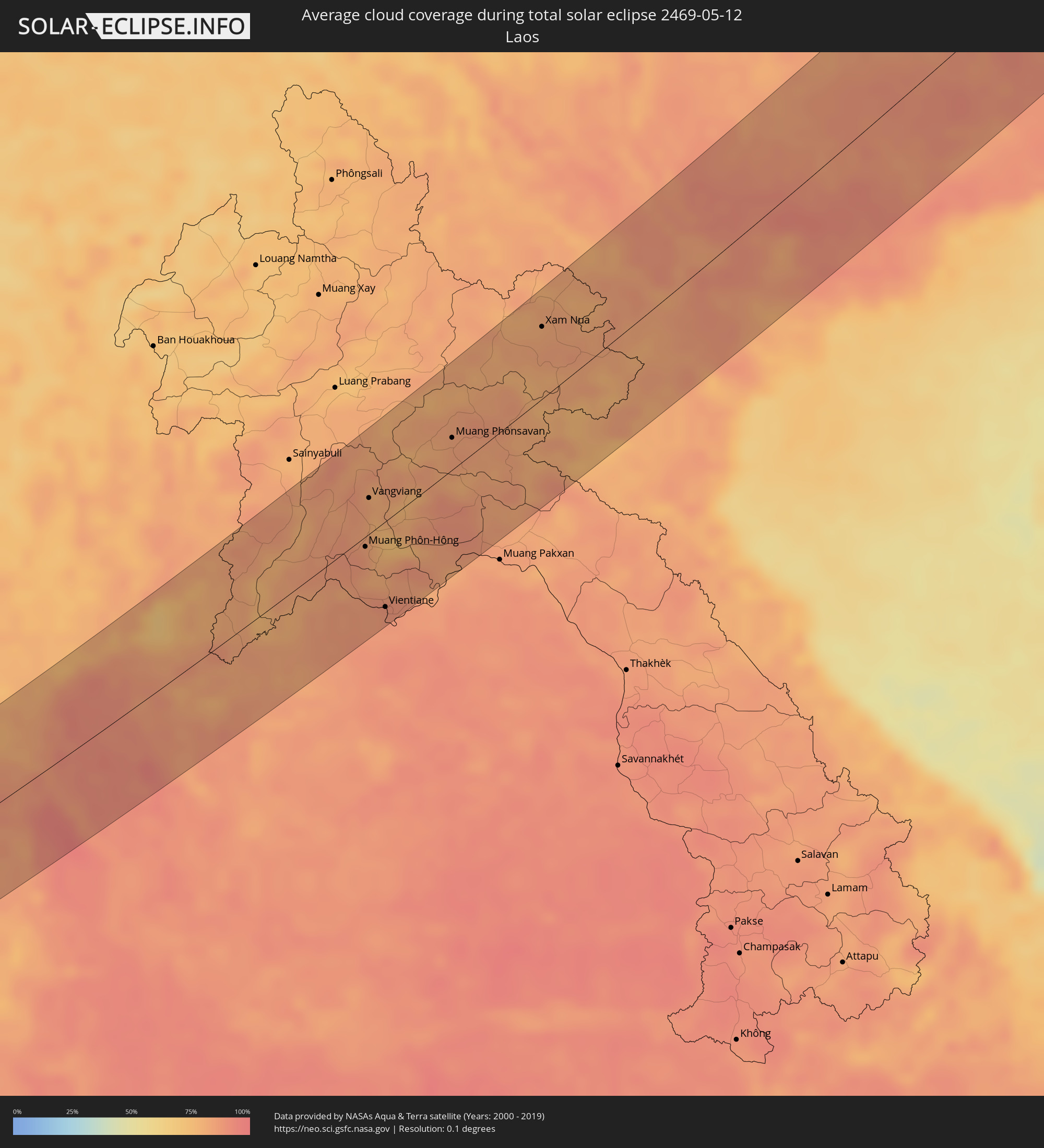 Laos
Laos
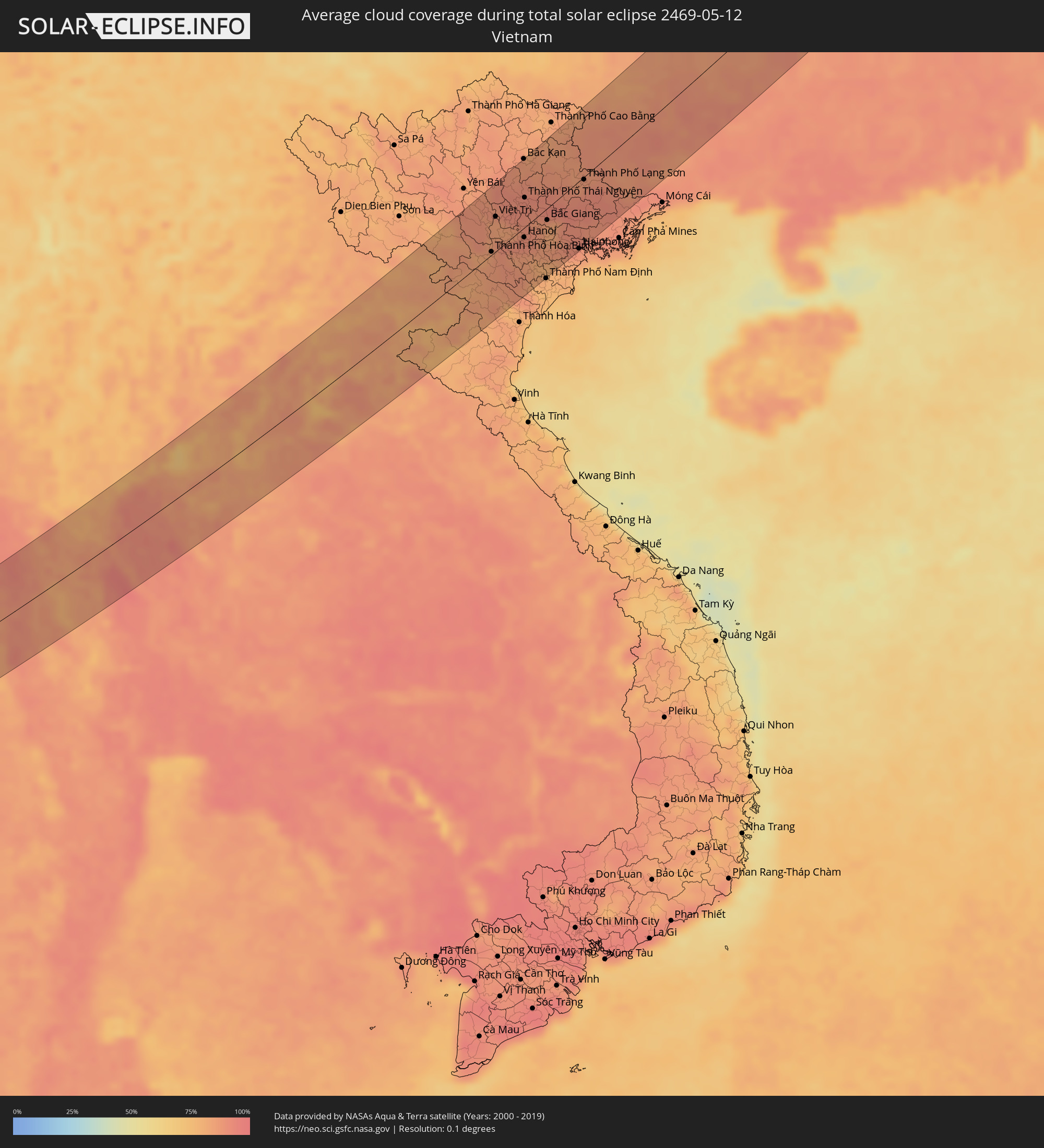 Vietnam
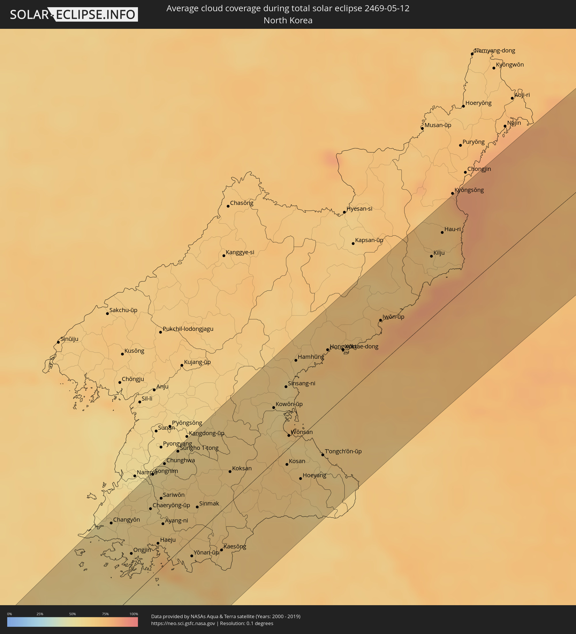 North Korea
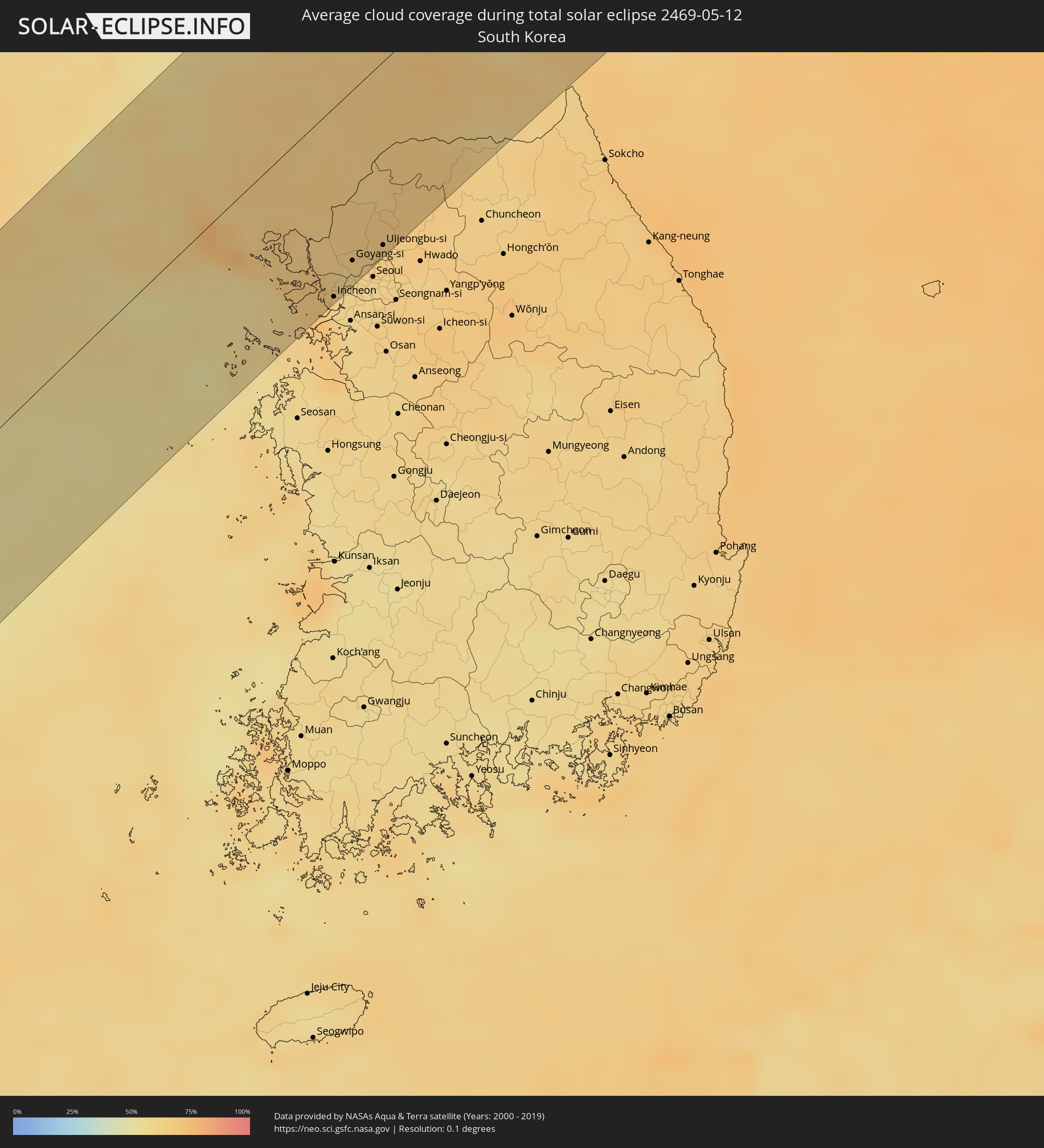 South Korea
Cities inside the path of the eclipse
The following table shows all locations with a population of more than 5,000 inside the eclipse path. Cities which have more than 100,000 inhabitants are marked bold. A click at the locations opens a detailed map.
| City | Type | Eclipse duration | Local time of max. eclipse | Distance to central line | Ø Cloud coverage |
|
Colombo, Western
|
total | - | 06:13:07 UTC+05:30 | 40 km | 82% |
|
Moratuwa, Western
|
total | - | 06:12:57 UTC+05:30 | 23 km | 84% |
|
Peliyagoda, Western
|
total | - | 06:13:08 UTC+05:30 | 43 km | 90% |
|
Wattala, Western
|
total | - | 06:13:09 UTC+05:30 | 44 km | 90% |
|
Ja Ela, Western
|
total | - | 06:13:14 UTC+05:30 | 54 km | 86% |
|
Kandana, Western
|
total | - | 06:13:13 UTC+05:30 | 51 km | 90% |
|
Kelaniya, Western
|
total | - | 06:13:07 UTC+05:30 | 40 km | 90% |
|
Kalutara, Western
|
total | - | 06:12:45 UTC+05:30 | 0 km | 85% |
|
Bentota, Southern
|
total | - | 06:12:36 UTC+05:30 | 18 km | 77% |
|
Homagama, Western
|
total | - | 06:13:00 UTC+05:30 | 25 km | 91% |
|
Ambalangoda, Southern
|
total | - | 06:12:24 UTC+05:30 | 40 km | 78% |
|
Hanwella Ihala, Western
|
total | - | 06:13:02 UTC+05:30 | 28 km | 93% |
|
Ratnapura, Sabaragamuwa
|
total | - | 06:12:45 UTC+05:30 | 7 km | 87% |
|
Gampola, Central
|
total | - | 06:13:11 UTC+05:30 | 37 km | 81% |
|
Kandy, Central
|
total | - | 06:13:18 UTC+05:30 | 48 km | 78% |
|
Nuwara Eliya, Central
|
total | - | 06:12:57 UTC+05:30 | 8 km | 72% |
|
Badulla, Uva
|
total | - | 06:12:55 UTC+05:30 | 1 km | 71% |
|
Eravur Town, Eastern Province
|
total | - | 06:13:36 UTC+05:30 | 59 km | 64% |
|
Batticaloa, Eastern Province
|
total | - | 06:13:31 UTC+05:30 | 48 km | 68% |
|
Kalmunai, Eastern Province
|
total | - | 06:13:12 UTC+05:30 | 11 km | 68% |
|
Bamboo Flat, Andaman and Nicobar Islands
|
total | - | 06:17:46 UTC+05:30 | 69 km | 89% |
|
Kyaikkami, Mon
|
total | - | 07:24:47 UTC+06:30 | 73 km | 83% |
|
Myawadi, Kayin
|
total | - | 07:26:00 UTC+06:30 | 73 km | 87% |
|
Mae Sot, Tak
|
total | - | 07:56:04 UTC+07:00 | 72 km | 87% |
|
Ban Tak, Tak
|
total | - | 07:56:44 UTC+07:00 | 70 km | 78% |
|
Tak, Tak
|
total | - | 07:56:30 UTC+07:00 | 52 km | 78% |
|
Kamphaeng Phet, Kamphaeng Phet
|
total | - | 07:56:04 UTC+07:00 | 8 km | 87% |
|
Ban Na, Sukhothai
|
total | - | 07:56:57 UTC+07:00 | 28 km | 93% |
|
Si Satchanalai, Sukhothai
|
total | - | 07:57:43 UTC+07:00 | 72 km | 89% |
|
Khiri Mat, Sukhothai
|
total | - | 07:56:42 UTC+07:00 | 7 km | 91% |
|
Sawankhalok, Sukhothai
|
total | - | 07:57:26 UTC+07:00 | 49 km | 91% |
|
Khanu Woralaksaburi, Kamphaeng Phet
|
total | - | 07:55:35 UTC+07:00 | 67 km | 89% |
|
Uttaradit, Uttaradit
|
total | - | 07:58:01 UTC+07:00 | 61 km | 87% |
|
Bang Rakam, Phitsanulok
|
total | - | 07:56:43 UTC+07:00 | 19 km | 91% |
|
Phitsanulok, Phitsanulok
|
total | - | 07:56:53 UTC+07:00 | 22 km | 90% |
|
Bang Krathum, Phitsanulok
|
total | - | 07:56:31 UTC+07:00 | 47 km | 91% |
|
Phichit, Phichit
|
total | - | 07:56:20 UTC+07:00 | 62 km | 92% |
|
Nakhon Thai, Phitsanulok
|
total | - | 07:57:32 UTC+07:00 | 33 km | 85% |
|
Loei, Loei
|
total | - | 07:58:32 UTC+07:00 | 54 km | 82% |
|
Wang Saphung, Loei
|
total | - | 07:58:15 UTC+07:00 | 73 km | 85% |
|
Nam Som, Changwat Udon Thani
|
total | - | 07:59:11 UTC+07:00 | 58 km | 86% |
|
Muang Phôn-Hông, Vientiane Province
|
total | - | 08:00:25 UTC+07:00 | 8 km | 86% |
|
Vangviang, Vientiane Province
|
total | - | 08:01:07 UTC+07:00 | 28 km | 84% |
|
Tha Bo, Nong Khai
|
total | - | 07:59:30 UTC+07:00 | 76 km | 87% |
|
Si Chiang Mai, Nong Khai
|
total | - | 07:59:40 UTC+07:00 | 67 km | 88% |
|
Vientiane, Vientiane
|
total | - | 07:59:41 UTC+07:00 | 67 km | 88% |
|
Muang Phônsavan, Xiangkhoang
|
total | - | 08:02:21 UTC+07:00 | 25 km | 84% |
|
Xam Nua, Houaphan
|
total | - | 08:04:23 UTC+07:00 | 54 km | 82% |
|
Thành Phố Hòa Bình, Hòa Bình
|
total | - | 08:05:49 UTC+07:00 | 4 km | 84% |
|
Việt Trì, Phú Thọ
|
total | - | 08:06:43 UTC+07:00 | 43 km | 84% |
|
Sơn Tây, Ha Nội
|
total | - | 08:06:28 UTC+07:00 | 20 km | 88% |
|
Vĩnh Yên, Vĩnh Phúc
|
total | - | 08:06:49 UTC+07:00 | 28 km | 88% |
|
Hà Đông, Ha Nội
|
total | - | 08:06:21 UTC+07:00 | 12 km | 89% |
|
Bắc Kạn, Bắc Kạn
|
total | - | 08:08:23 UTC+07:00 | 84 km | 85% |
|
Hanoi, Ha Nội
|
total | - | 08:06:29 UTC+07:00 | 12 km | 89% |
|
Thành Phố Thái Nguyên, Thái Nguyên
|
total | - | 08:07:27 UTC+07:00 | 36 km | 91% |
|
Thành Phố Phủ Lý, Hà Nam
|
total | - | 08:05:44 UTC+07:00 | 58 km | 83% |
|
Hưng Yên, Hưng Yên
|
total | - | 08:05:59 UTC+07:00 | 58 km | 80% |
|
Bắc Ninh, Bắc Ninh
|
total | - | 08:06:55 UTC+07:00 | 14 km | 86% |
|
Bắc Giang, Bắc Giang
|
total | - | 08:07:08 UTC+07:00 | 14 km | 85% |
|
Thành Phố Hải Dương, Hải Dương
|
total | - | 08:06:40 UTC+07:00 | 52 km | 87% |
|
Haiphong, Hải Phòng
|
total | - | 08:06:46 UTC+07:00 | 82 km | 87% |
|
Thành Phố Lạng Sơn, Lạng Sơn
|
total | - | 08:08:30 UTC+07:00 | 3 km | 87% |
|
Thành Phố Uông Bí, Quảng Ninh
|
total | - | 08:07:07 UTC+07:00 | 73 km | 87% |
|
Nanning, Guangxi Zhuang Autonomous Region
|
total | - | 09:11:16 UTC+08:00 | 27 km | 91% |
|
Guilin, Guangxi Zhuang Autonomous Region
|
total | - | 09:17:13 UTC+08:00 | 41 km | 81% |
|
Yangshuo, Guangxi Zhuang Autonomous Region
|
total | - | 09:16:28 UTC+08:00 | 14 km | 83% |
|
Hengyang, Hunan
|
total | - | 09:22:13 UTC+08:00 | 9 km | 80% |
|
Xiangtan, Hunan
|
total | - | 09:24:16 UTC+08:00 | 67 km | 80% |
|
Zhuzhou, Hunan
|
total | - | 09:24:29 UTC+08:00 | 48 km | 78% |
|
Guankou, Hunan
|
total | - | 09:25:33 UTC+08:00 | 41 km | 78% |
|
Pingxiang, Jiangxi
|
total | - | 09:24:45 UTC+08:00 | 18 km | 79% |
|
Nanchang, Jiangxi
|
total | - | 09:28:48 UTC+08:00 | 71 km | 78% |
|
Jiujiang, Jiangxi
|
total | - | 09:30:54 UTC+08:00 | 0 km | 75% |
|
Anqing, Anhui
|
total | - | 09:33:35 UTC+08:00 | 8 km | 71% |
|
Hefei, Anhui
|
total | - | 09:36:26 UTC+08:00 | 81 km | 66% |
|
Wusong, Anhui
|
total | - | 09:35:15 UTC+08:00 | 24 km | 70% |
|
Chuzhou, Anhui
|
total | - | 09:38:28 UTC+08:00 | 49 km | 61% |
|
Wuhu, Anhui
|
total | - | 09:36:40 UTC+08:00 | 34 km | 68% |
|
Nanjing, Jiangsu
|
total | - | 09:38:32 UTC+08:00 | 4 km | 62% |
|
Yangzhou, Jiangsu
|
total | - | 09:39:58 UTC+08:00 | 22 km | 60% |
|
Zhenjiang, Jiangsu
|
total | - | 09:39:38 UTC+08:00 | 38 km | 63% |
|
Taizhou, Jiangsu
|
total | - | 09:40:43 UTC+08:00 | 46 km | 62% |
|
Yancheng, Jiangsu
|
total | - | 09:42:40 UTC+08:00 | 6 km | 61% |
|
Changyŏn, Hwanghae-namdo
|
total | - | 10:58:16 UTC+09:00 | 77 km | 58% |
|
Ongjin, Hwanghae-namdo
|
total | - | 10:58:04 UTC+09:00 | 36 km | 61% |
|
Chaeryŏng-ŭp, Hwanghae-namdo
|
total | - | 10:59:15 UTC+09:00 | 58 km | 58% |
|
Songnim, Hwanghae-bukto
|
total | - | 10:59:56 UTC+09:00 | 85 km | 55% |
|
Haeju, Hwanghae-namdo
|
total | - | 10:58:45 UTC+09:00 | 23 km | 68% |
|
Sariwŏn, Hwanghae-bukto
|
total | - | 10:59:38 UTC+09:00 | 58 km | 61% |
|
Hŭkkyo-ri, Hwanghae-bukto
|
total | - | 11:00:13 UTC+09:00 | 79 km | 58% |
|
Sŭngho 1-tong, Pyongyang
|
total | - | 11:00:49 UTC+09:00 | 84 km | 59% |
|
Yŏnan-ŭp, Hwanghae-namdo
|
total | - | 10:59:08 UTC+09:00 | 15 km | 65% |
|
Ganghwa-gun, Incheon
|
total | - | 10:59:18 UTC+09:00 | 47 km | 67% |
|
Kaesŏng, Hwanghae-namdo
|
total | - | 10:59:48 UTC+09:00 | 33 km | 64% |
|
Incheon, Incheon
|
total | - | 10:59:05 UTC+09:00 | 84 km | 60% |
|
Bucheon-si, Gyeonggi-do
|
total | - | 10:59:16 UTC+09:00 | 85 km | 60% |
|
Munsan, Gyeonggi-do
|
total | - | 10:59:56 UTC+09:00 | 56 km | 65% |
|
Goyang-si, Gyeonggi-do
|
total | - | 10:59:38 UTC+09:00 | 76 km | 62% |
|
Uijeongbu-si, Gyeonggi-do
|
total | - | 11:00:06 UTC+09:00 | 82 km | 64% |
|
Yangju, Gyeonggi-do
|
total | - | 11:00:17 UTC+09:00 | 75 km | 66% |
|
Kowŏn-ŭp, Hamgyŏng-namdo
|
total | - | 11:03:23 UTC+09:00 | 45 km | 61% |
|
Kosan, Kangwŏn-do
|
total | - | 11:02:37 UTC+09:00 | 13 km | 68% |
|
Wŏnsan, Kangwŏn-do
|
total | - | 11:03:10 UTC+09:00 | 10 km | 60% |
|
Yŏnggwang-ŭp, Hamgyŏng-namdo
|
total | - | 11:04:42 UTC+09:00 | 80 km | 65% |
|
Hamhŭng, Hamgyŏng-namdo
|
total | - | 11:04:39 UTC+09:00 | 67 km | 63% |
|
Hoeyang, Kangwŏn-do
|
total | - | 11:02:37 UTC+09:00 | 35 km | 65% |
|
Hongwŏn, Hamgyŏng-namdo
|
total | - | 11:05:26 UTC+09:00 | 52 km | 74% |
|
Yuktae-dong, Hamgyŏng-namdo
|
total | - | 11:05:43 UTC+09:00 | 40 km | 71% |
|
Iwŏn-ŭp, Hamgyŏng-namdo
|
total | - | 11:06:57 UTC+09:00 | 36 km | 76% |
|
Kilju, Hamgyŏng-bukto
|
total | - | 11:09:01 UTC+09:00 | 51 km | 67% |
|
Dunay, Primorskiy
|
total | - | 12:16:33 UTC+10:00 | 50 km | 76% |
|
Bol’shoy Kamen’, Primorskiy
|
total | - | 12:16:56 UTC+10:00 | 69 km | 66% |
|
Fokino, Primorskiy
|
total | - | 12:16:48 UTC+10:00 | 55 km | 69% |
|
Smolyaninovo, Primorskiy
|
total | - | 12:17:21 UTC+10:00 | 79 km | 67% |
|
Livadiya, Primorskiy
|
total | - | 12:17:03 UTC+10:00 | 32 km | 75% |
|
Nakhodka, Primorskiy
|
total | - | 12:17:16 UTC+10:00 | 17 km | 74% |
|
Vrangel’, Primorskiy
|
total | - | 12:17:27 UTC+10:00 | 1 km | 75% |
|
Partizansk, Primorskiy
|
total | - | 12:18:07 UTC+10:00 | 31 km | 70% |
|
Uglekamensk, Primorskiy
|
total | - | 12:18:25 UTC+10:00 | 34 km | 68% |
|
Chuguyevka, Primorskiy
|
total | - | 12:20:46 UTC+10:00 | 84 km | 74% |
|
Preobrazheniye, Primorskiy
|
total | - | 12:18:58 UTC+10:00 | 28 km | 79% |
|
Kavalerovo, Primorskiy
|
total | - | 12:22:43 UTC+10:00 | 35 km | 72% |
|
Dal'negorsk, Primorskiy
|
total | - | 12:23:55 UTC+10:00 | 36 km | 72% |
|
Plastun, Primorskiy
|
total | - | 12:25:17 UTC+10:00 | 20 km | 76% |
|
Gornozavodsk, Sakhalin
|
total | - | 13:36:07 UTC+11:00 | 57 km | 67% |
|
Nevel’sk, Sakhalin
|
total | - | 13:36:15 UTC+11:00 | 46 km | 68% |
|
Kholmsk, Sakhalin
|
total | - | 13:36:57 UTC+11:00 | 19 km | 75% |
|
Aniva, Sakhalin
|
total | - | 13:37:21 UTC+11:00 | 70 km | 71% |
|
Yuzhno-Sakhalinsk, Sakhalin
|
total | - | 13:37:55 UTC+11:00 | 55 km | 72% |
|
Dolinsk, Sakhalin
|
total | - | 13:38:23 UTC+11:00 | 21 km | 75% |