Total solar eclipse of 10/07/2507
| Day of week: | Friday |
| Maximum duration of eclipse: | 03m07s |
| Maximum width of eclipse path: | 374 km |
| Saros cycle: | 142 |
| Coverage: | 100% |
| Magnitude: | 1.0464 |
| Gamma: | 0.9141 |
Wo kann man die Sonnenfinsternis vom 10/07/2507 sehen?
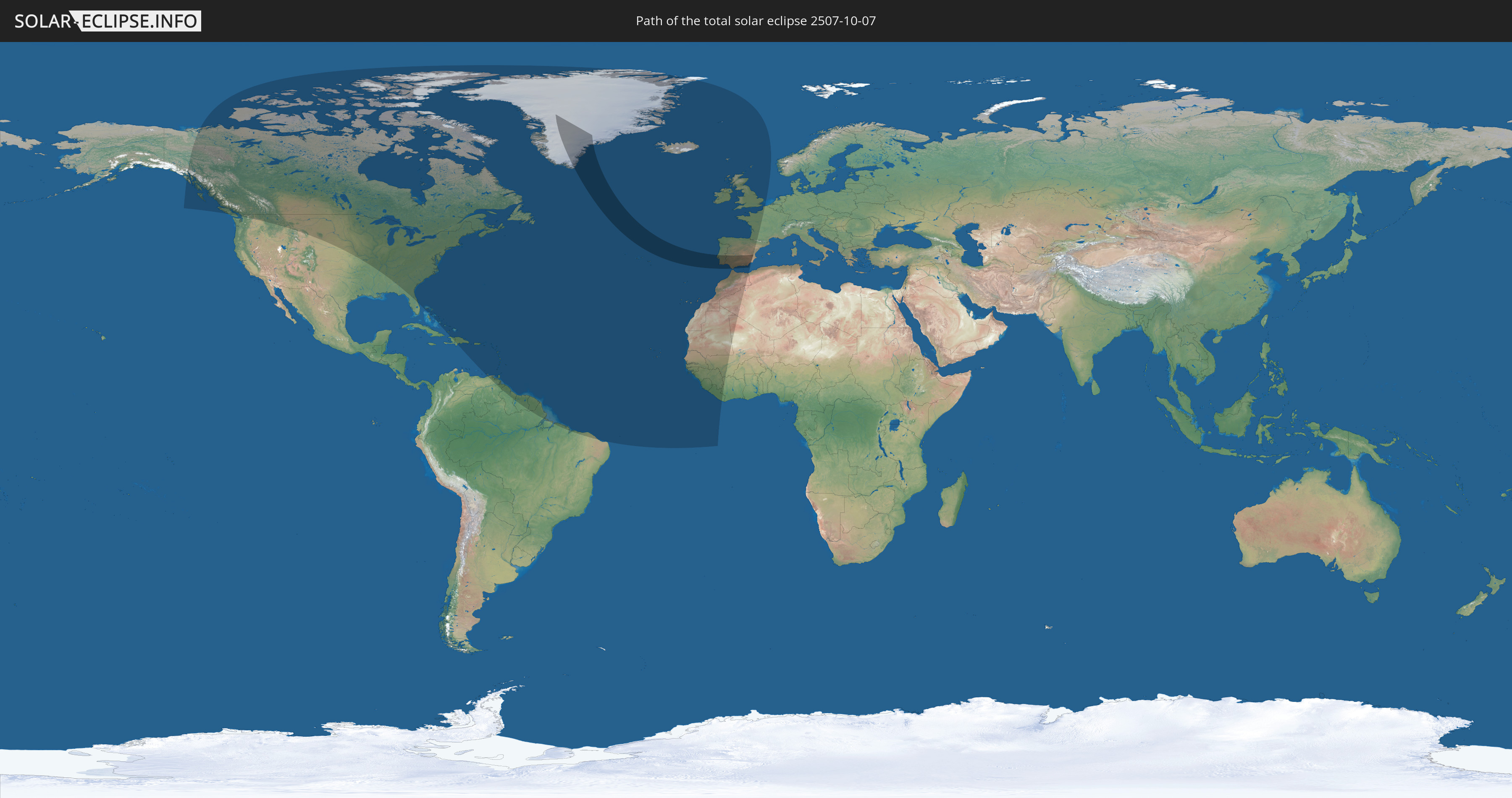
Die Sonnenfinsternis am 10/07/2507 kann man in 55 Ländern als partielle Sonnenfinsternis beobachten.
Der Finsternispfad verläuft durch 4 Länder. Nur in diesen Ländern ist sie als total Sonnenfinsternis zu sehen.
In den folgenden Ländern ist die Sonnenfinsternis total zu sehen
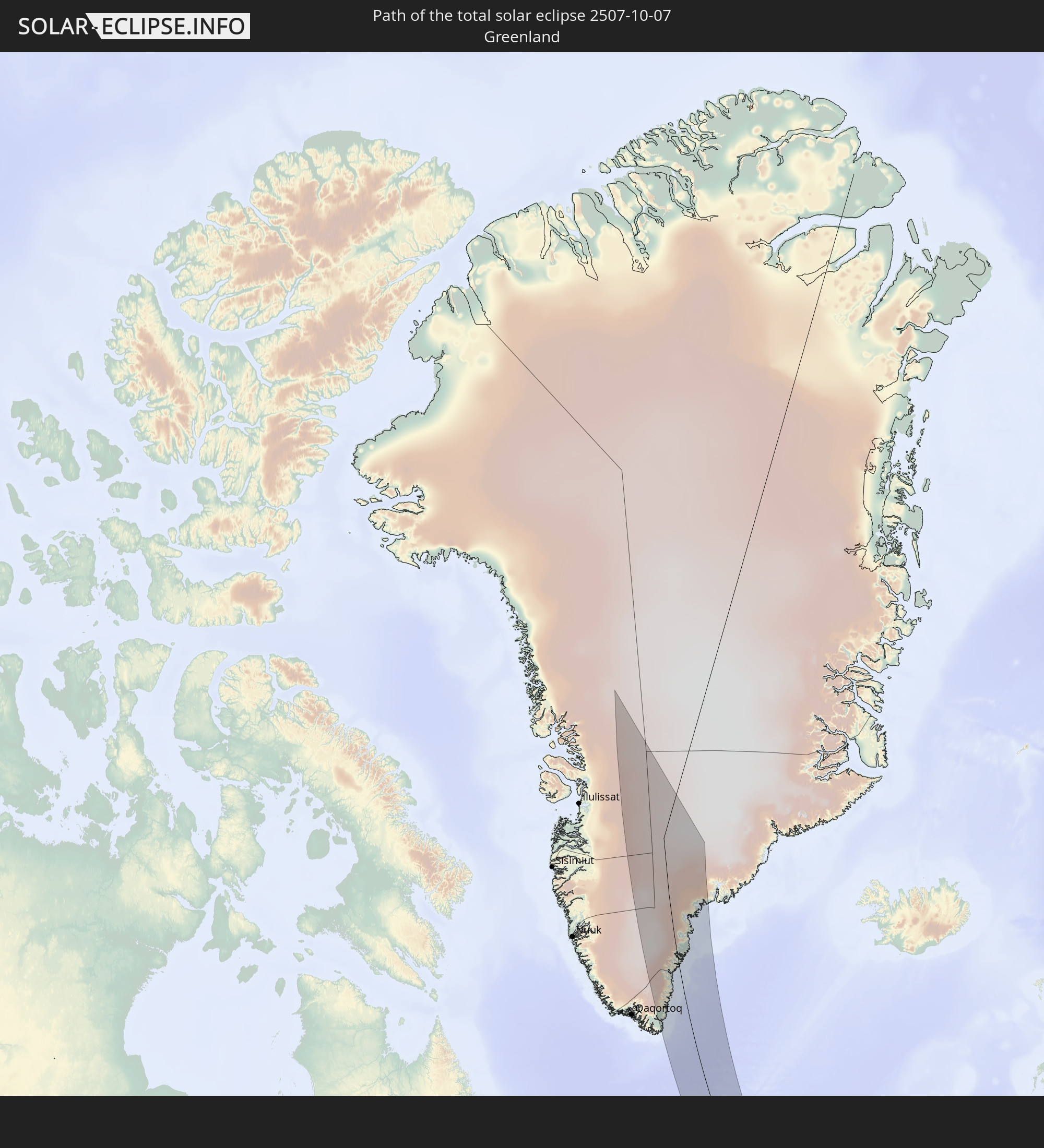 Greenland
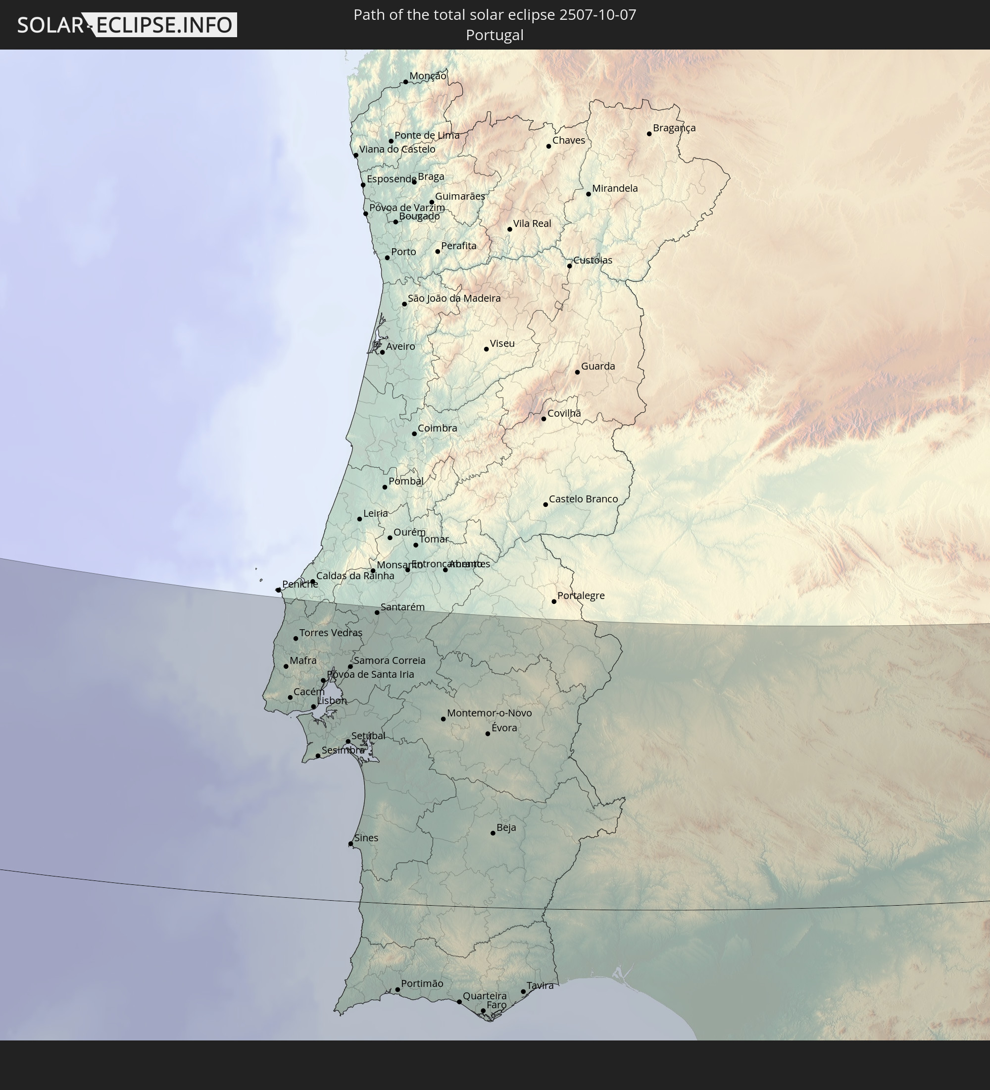 Portugal
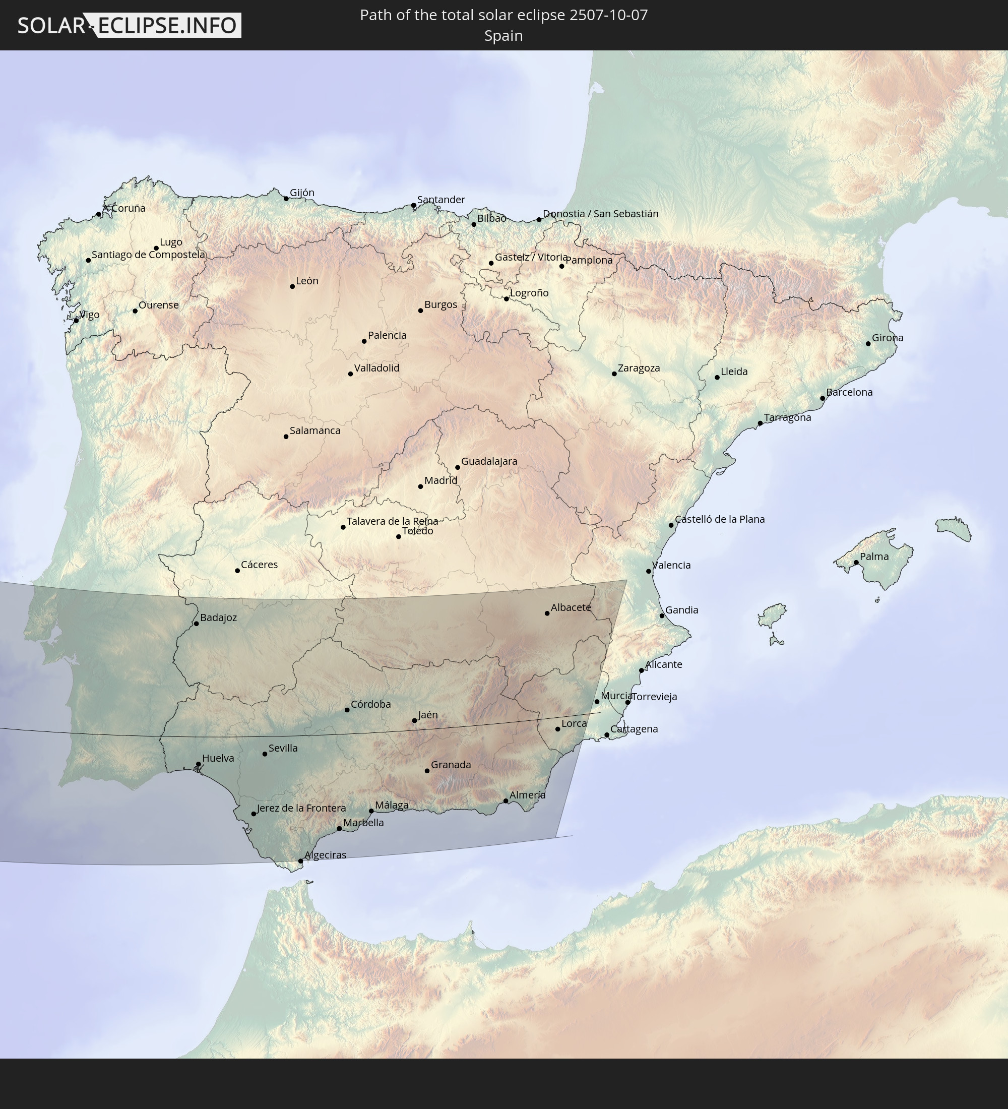 Spain
Spain
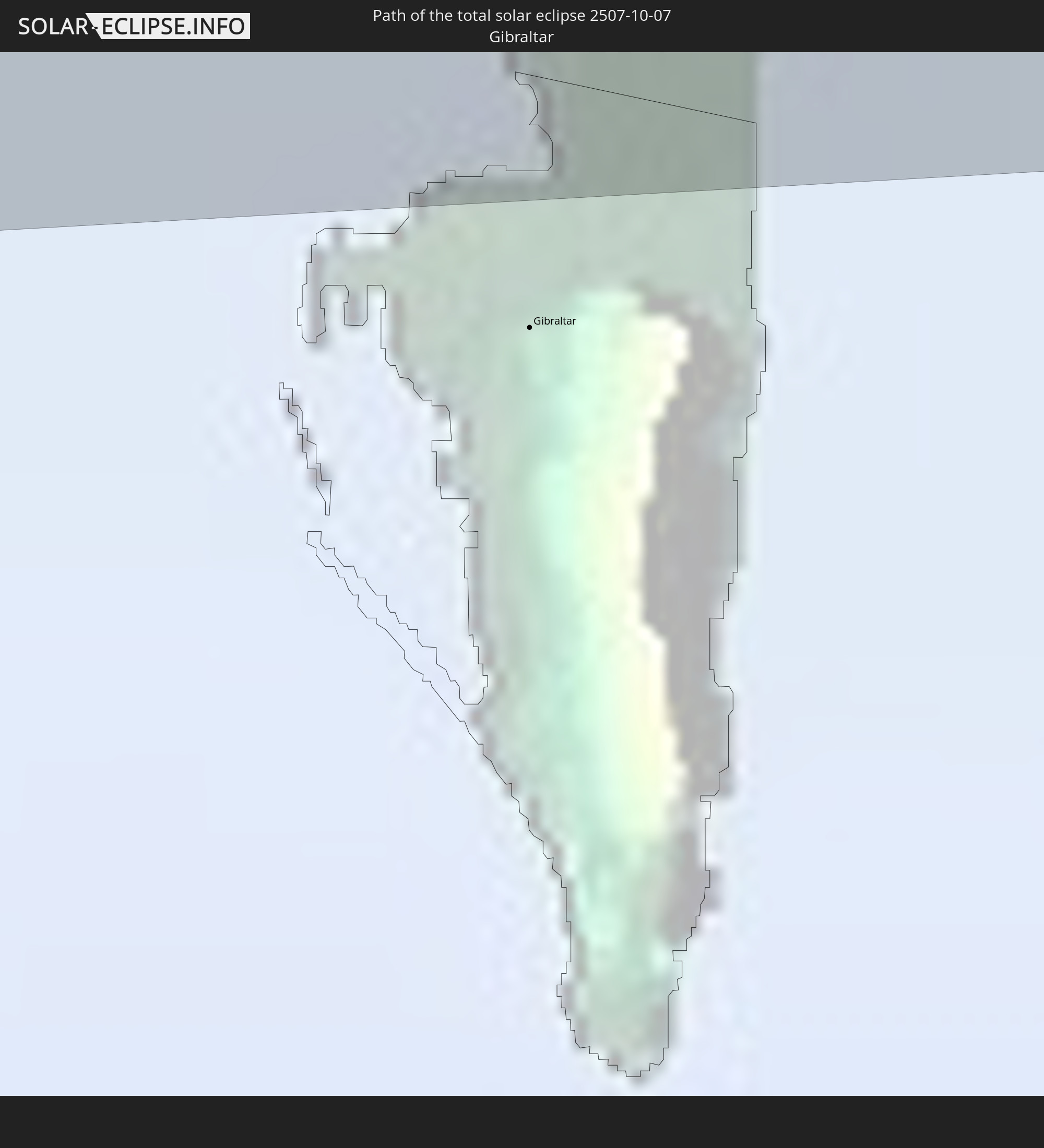 Gibraltar
In den folgenden Ländern ist die Sonnenfinsternis partiell zu sehen
 United States
 Canada
 Greenland
 The Bahamas
 Haiti
Haiti
 Brazil
 Venezuela
 Turks and Caicos Islands
 Dominican Republic
 Puerto Rico
 United States Virgin Islands
 Bermuda
 British Virgin Islands
 Anguilla
 Collectivity of Saint Martin
 Saint Barthélemy
 Saint Kitts and Nevis
 Antigua and Barbuda
 Montserrat
 Trinidad and Tobago
 Guadeloupe
 Grenada
 Dominica
 Saint Vincent and the Grenadines
 Guyana
 Martinique
 Saint Lucia
 Barbados
 Suriname
 Saint Pierre and Miquelon
 French Guiana
 Portugal
 Cabo Verde
 Iceland
 Spain
Spain
 Senegal
 Mauritania
 The Gambia
 Guinea-Bissau
 Guinea
 Sierra Leone
 Morocco
 Mali
Mali
 Liberia
 Republic of Ireland
 Svalbard and Jan Mayen
 Algeria
 United Kingdom
 Ivory Coast
 Faroe Islands
 Gibraltar
 France
 Isle of Man
 Guernsey
 Jersey
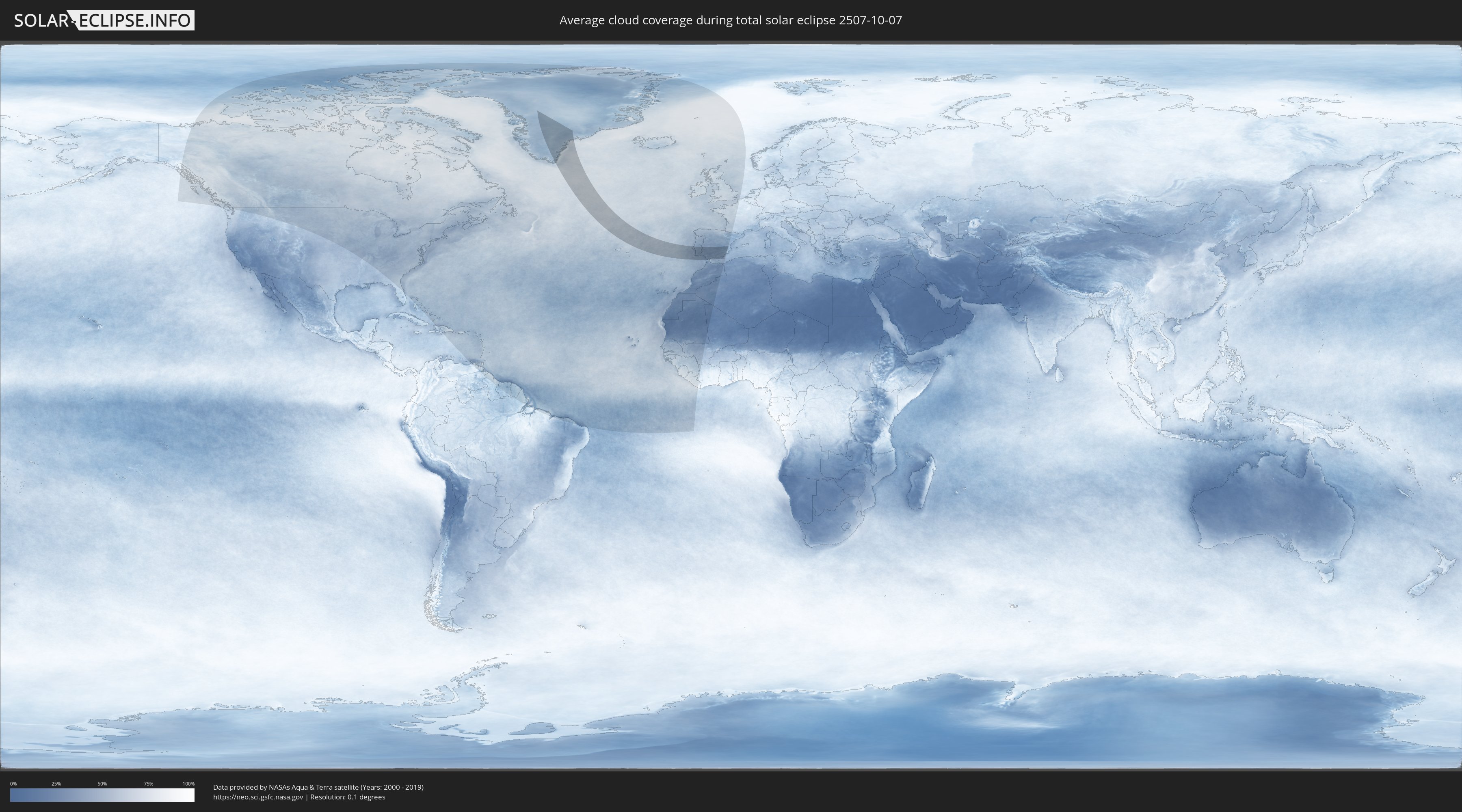
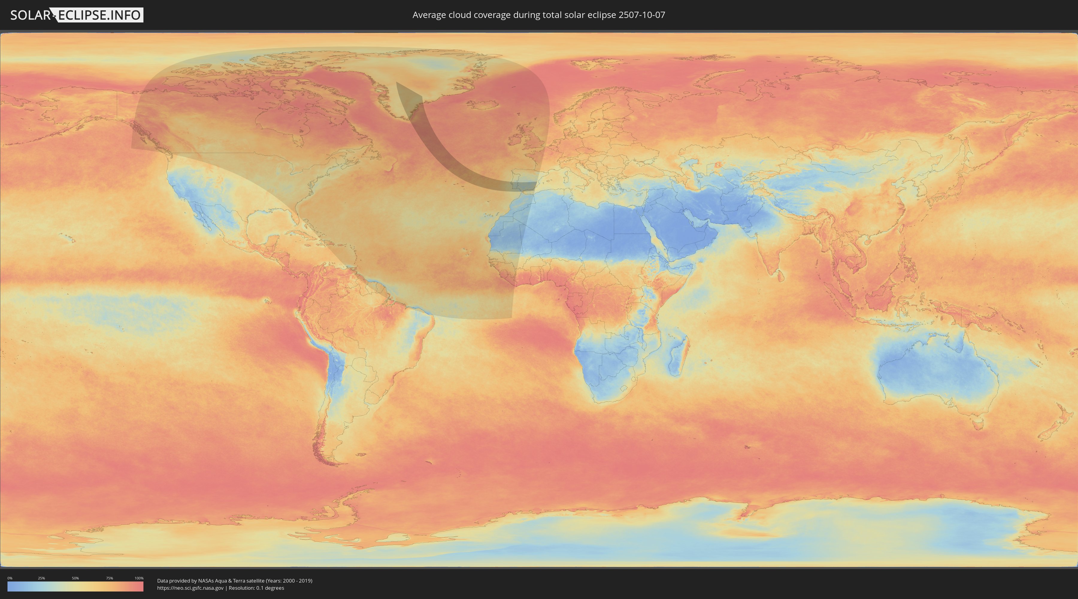
How will be the weather during the total solar eclipse on 10/07/2507?
Where is the best place to see the total solar eclipse of 10/07/2507?
The following maps show the average cloud coverage for the day of the total solar eclipse.
With the help of these maps, it is possible to find the place along the eclipse path, which has the best
chance of a cloudless sky.
Nevertheless, you should consider local circumstances and inform about the weather of your chosen
observation site.
The data is provided by NASAs satellites
AQUA and TERRA.
The cloud maps are averaged over a period of 19 years (2000 - 2019).
Detailed country maps
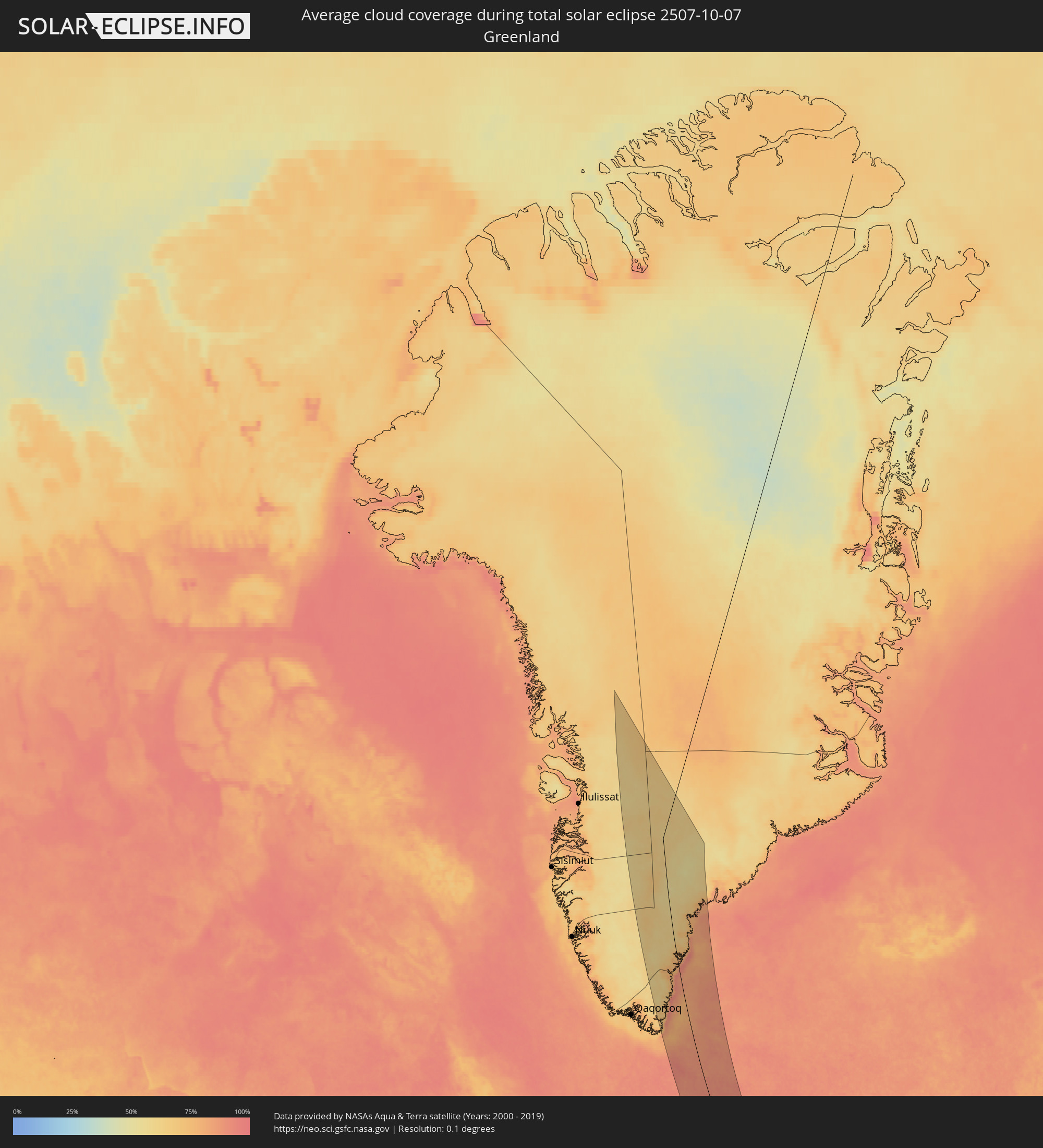 Greenland
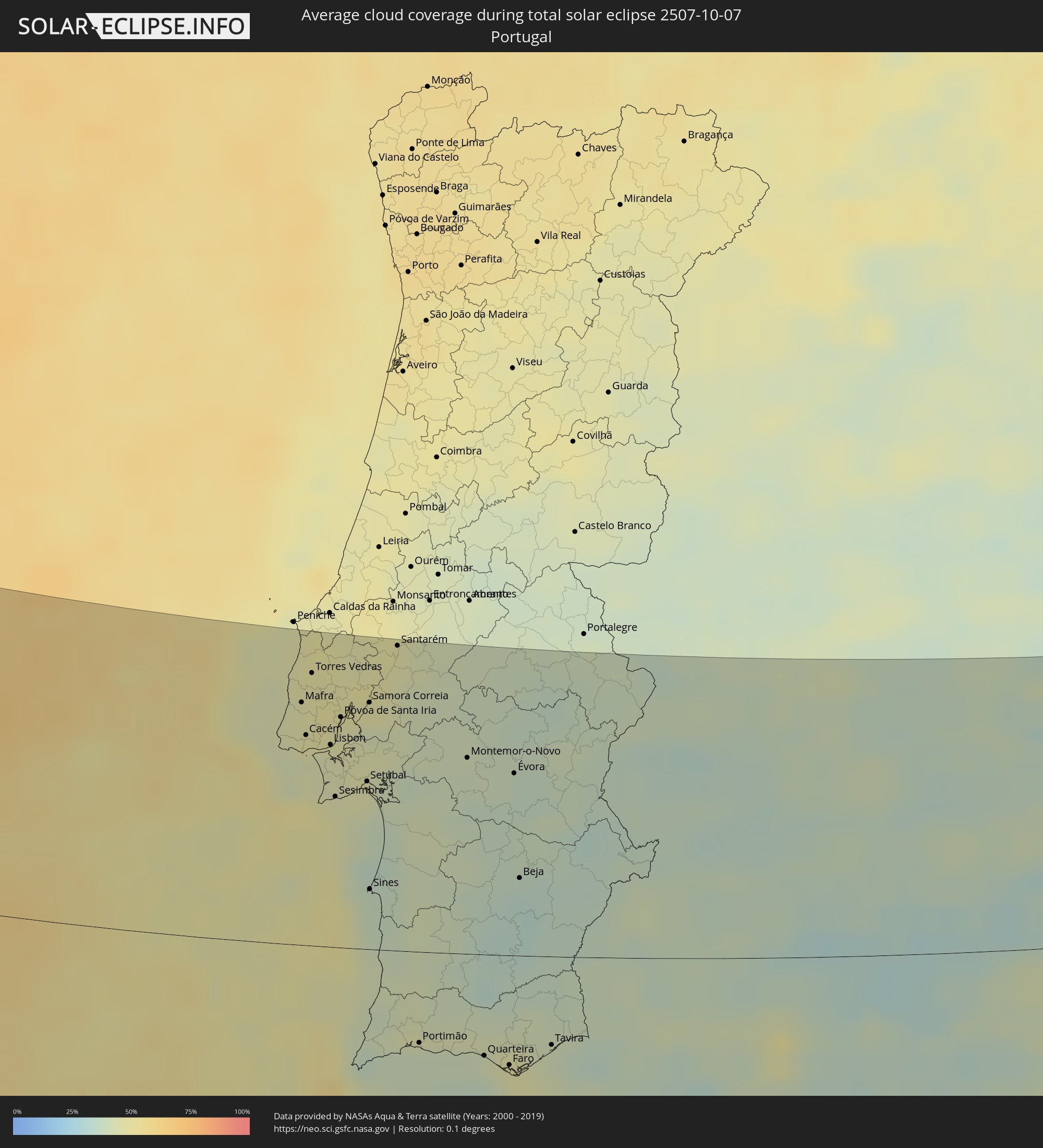 Portugal
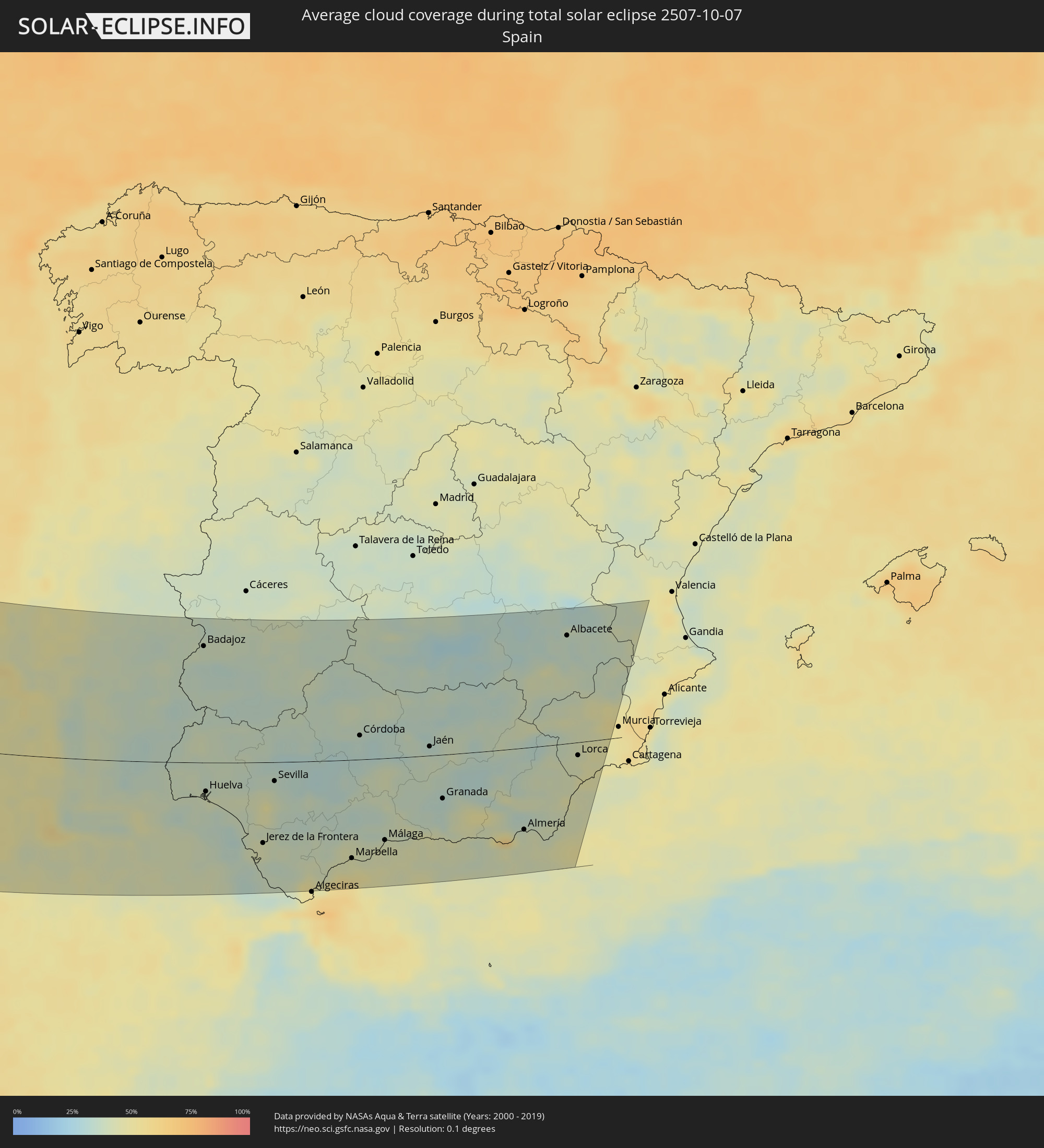 Spain
Spain
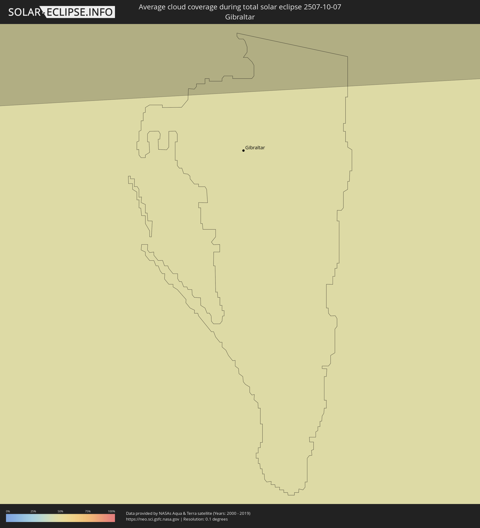 Gibraltar
Cities inside the path of the eclipse
The following table shows all locations with a population of more than 5,000 inside the eclipse path. Cities which have more than 100,000 inhabitants are marked bold. A click at the locations opens a detailed map.
| City | Type | Eclipse duration | Local time of max. eclipse | Distance to central line | Ø Cloud coverage |
|
Colares, Lisbon
|
total | - | 17:31:15 UTC+00:00 | 126 km | 45% |
|
Ericeira, Lisbon
|
total | - | 17:30:59 UTC+00:00 | 144 km | 45% |
|
São João das Lampas, Lisbon
|
total | - | 17:31:08 UTC+00:00 | 134 km | 45% |
|
Silveira, Lisbon
|
total | - | 17:30:44 UTC+00:00 | 161 km | 46% |
|
Parede, Lisbon
|
total | - | 17:31:29 UTC+00:00 | 115 km | 43% |
|
Mafra, Lisbon
|
total | - | 17:31:03 UTC+00:00 | 142 km | 47% |
|
Carcavelos, Lisbon
|
total | - | 17:31:30 UTC+00:00 | 115 km | 44% |
|
Lourinhã, Lisbon
|
total | - | 17:30:32 UTC+00:00 | 175 km | 48% |
|
Porto Salvo, Lisbon
|
total | - | 17:31:28 UTC+00:00 | 118 km | 44% |
|
Cacém, Lisbon
|
total | - | 17:31:22 UTC+00:00 | 123 km | 48% |
|
A dos Cunhados, Lisbon
|
total | - | 17:30:41 UTC+00:00 | 166 km | 48% |
|
Barcarena, Lisbon
|
total | - | 17:31:26 UTC+00:00 | 119 km | 44% |
|
Almargem, Lisbon
|
total | - | 17:31:15 UTC+00:00 | 132 km | 48% |
|
Quejas, Lisbon
|
total | - | 17:31:28 UTC+00:00 | 118 km | 44% |
|
Belas, Lisbon
|
total | - | 17:31:22 UTC+00:00 | 124 km | 48% |
|
Torres Vedras, Lisbon
|
total | - | 17:30:48 UTC+00:00 | 159 km | 47% |
|
Linda-a-Velha, Lisbon
|
total | - | 17:31:29 UTC+00:00 | 118 km | 44% |
|
Costa de Caparica, Setúbal
|
total | - | 17:31:37 UTC+00:00 | 110 km | 44% |
|
Algés, Lisbon
|
total | - | 17:31:31 UTC+00:00 | 116 km | 44% |
|
Caneças, Lisbon
|
total | - | 17:31:19 UTC+00:00 | 129 km | 46% |
|
Famões, Lisbon
|
total | - | 17:31:22 UTC+00:00 | 126 km | 46% |
|
Caparica, Setúbal
|
total | - | 17:31:35 UTC+00:00 | 113 km | 44% |
|
Milharado, Lisbon
|
total | - | 17:31:05 UTC+00:00 | 144 km | 47% |
|
Ramada, Lisbon
|
total | - | 17:31:21 UTC+00:00 | 128 km | 46% |
|
Sobreda, Setúbal
|
total | - | 17:31:37 UTC+00:00 | 111 km | 44% |
|
Pragal, Setúbal
|
total | - | 17:31:35 UTC+00:00 | 114 km | 44% |
|
Póvoa de Santo Adrião, Lisbon
|
total | - | 17:31:22 UTC+00:00 | 128 km | 46% |
|
Olival do Basto, Lisbon
|
total | - | 17:31:23 UTC+00:00 | 127 km | 46% |
|
Bombarral, Leiria
|
total | - | 17:30:32 UTC+00:00 | 180 km | 49% |
|
Piedade, Setúbal
|
total | - | 17:31:36 UTC+00:00 | 113 km | 44% |
|
Cacilhas, Setúbal
|
total | - | 17:31:34 UTC+00:00 | 115 km | 44% |
|
Lisbon, Lisbon
|
total | - | 17:31:32 UTC+00:00 | 119 km | 44% |
|
Apelação, Lisbon
|
total | - | 17:31:21 UTC+00:00 | 129 km | 46% |
|
Camarate, Lisbon
|
total | - | 17:31:22 UTC+00:00 | 128 km | 46% |
|
Unhos, Lisbon
|
total | - | 17:31:20 UTC+00:00 | 131 km | 46% |
|
Sacavém, Lisbon
|
total | - | 17:31:24 UTC+00:00 | 127 km | 46% |
|
Moscavide, Lisbon
|
total | - | 17:31:26 UTC+00:00 | 126 km | 46% |
|
Sesimbra, Setúbal
|
total | - | 17:32:01 UTC+00:00 | 88 km | 46% |
|
Bobadela, Lisbon
|
total | - | 17:31:23 UTC+00:00 | 129 km | 46% |
|
São João da Talha, Lisbon
|
total | - | 17:31:21 UTC+00:00 | 130 km | 46% |
|
Santa Iria da Azóia, Lisbon
|
total | - | 17:31:19 UTC+00:00 | 133 km | 46% |
|
Aldeia de Paio Pires, Setúbal
|
total | - | 17:31:43 UTC+00:00 | 108 km | 43% |
|
Arruda dos Vinhos, Lisbon
|
total | - | 17:31:04 UTC+00:00 | 149 km | 48% |
|
Vialonga, Lisbon
|
total | - | 17:31:16 UTC+00:00 | 136 km | 47% |
|
Póvoa de Santa Iria, Lisbon
|
total | - | 17:31:18 UTC+00:00 | 135 km | 47% |
|
Santo António da Charneca, Setúbal
|
total | - | 17:31:44 UTC+00:00 | 109 km | 45% |
|
Alhos Vedros, Setúbal
|
total | - | 17:31:41 UTC+00:00 | 112 km | 45% |
|
Alenquer, Lisbon
|
total | - | 17:30:58 UTC+00:00 | 157 km | 48% |
|
Alhandra, Lisbon
|
total | - | 17:31:12 UTC+00:00 | 143 km | 45% |
|
Moita, Setúbal
|
total | - | 17:31:42 UTC+00:00 | 112 km | 45% |
|
Vila Franca de Xira, Lisbon
|
total | - | 17:31:09 UTC+00:00 | 146 km | 47% |
|
Carregado, Lisbon
|
total | - | 17:31:02 UTC+00:00 | 154 km | 47% |
|
Castanheira do Ribatejo, Lisbon
|
total | - | 17:31:06 UTC+00:00 | 150 km | 47% |
|
Alcochete, Setúbal
|
total | - | 17:31:31 UTC+00:00 | 124 km | 45% |
|
Quinta do Anjo, Setúbal
|
total | - | 17:31:52 UTC+00:00 | 103 km | 46% |
|
Palmela, Setúbal
|
total | - | 17:31:53 UTC+00:00 | 103 km | 46% |
|
Setúbal, Setúbal
|
total | - | 17:31:58 UTC+00:00 | 99 km | 45% |
|
Samora Correia, Santarém
|
total | - | 17:31:14 UTC+00:00 | 144 km | 42% |
|
Sines, Setúbal
|
total | - | 17:32:59 UTC+00:00 | 35 km | 38% |
|
Azambuja, Lisbon
|
total | - | 17:31:00 UTC+00:00 | 159 km | 49% |
|
Benavente, Santarém
|
total | - | 17:31:11 UTC+00:00 | 149 km | 47% |
|
Cartaxo, Santarém
|
total | - | 17:30:52 UTC+00:00 | 170 km | 47% |
|
Santo André, Setúbal
|
total | - | 17:32:51 UTC+00:00 | 47 km | 35% |
|
Santiago do Cacém, Setúbal
|
total | - | 17:32:56 UTC+00:00 | 43 km | 37% |
|
Santarém, Santarém
|
total | - | 17:30:46 UTC+00:00 | 178 km | 46% |
|
Lagos, Faro
|
total | - | 17:34:33 UTC+00:00 | 59 km | 38% |
|
Almeirim, Santarém
|
total | - | 17:30:51 UTC+00:00 | 176 km | 45% |
|
Alpiarça, Santarém
|
total | - | 17:30:46 UTC+00:00 | 181 km | 44% |
|
Fazendas de Almeirim, Santarém
|
total | - | 17:30:55 UTC+00:00 | 172 km | 45% |
|
Grândola, Setúbal
|
total | - | 17:32:42 UTC+00:00 | 61 km | 40% |
|
Portimão, Faro
|
total | - | 17:34:32 UTC+00:00 | 54 km | 39% |
|
Coruche, Santarém
|
total | - | 17:31:19 UTC+00:00 | 149 km | 41% |
|
Alcácer do Sal, Setúbal
|
total | - | 17:32:22 UTC+00:00 | 83 km | 42% |
|
Estômbar, Faro
|
total | - | 17:34:33 UTC+00:00 | 53 km | 39% |
|
Vendas Novas, Évora
|
total | - | 17:31:51 UTC+00:00 | 118 km | 42% |
|
Lagoa, Faro
|
total | - | 17:34:34 UTC+00:00 | 54 km | 39% |
|
Silves, Faro
|
total | - | 17:34:29 UTC+00:00 | 48 km | 43% |
|
São Bartolomeu de Messines, Faro
|
total | - | 17:34:25 UTC+00:00 | 39 km | 42% |
|
Albufeira, Faro
|
total | - | 17:34:44 UTC+00:00 | 58 km | 39% |
|
Santo André, Portalegre
|
total | - | 17:31:15 UTC+00:00 | 160 km | 39% |
|
Montemor-o-Novo, Évora
|
total | - | 17:31:59 UTC+00:00 | 115 km | 39% |
|
Quarteira, Faro
|
total | - | 17:34:49 UTC+00:00 | 60 km | 41% |
|
Almancil, Faro
|
total | - | 17:34:48 UTC+00:00 | 58 km | 44% |
|
Loulé, Faro
|
total | - | 17:34:43 UTC+00:00 | 52 km | 44% |
|
Faro, Faro
|
total | - | 17:34:57 UTC+00:00 | 65 km | 46% |
|
Évora, Évora
|
total | - | 17:32:15 UTC+00:00 | 107 km | 37% |
|
São Brás de Alportel, Faro
|
total | - | 17:34:44 UTC+00:00 | 50 km | 42% |
|
Beja, Beja
|
total | - | 17:33:14 UTC+00:00 | 46 km | 34% |
|
Laranjeiro, Faro
|
total | - | 17:34:55 UTC+00:00 | 59 km | 44% |
|
Moncarapacho, Faro
|
total | - | 17:34:53 UTC+00:00 | 57 km | 44% |
|
Vale da Amoreira, Portalegre
|
total | - | 17:31:25 UTC+00:00 | 164 km | 36% |
|
Tavira, Faro
|
total | - | 17:34:52 UTC+00:00 | 52 km | 39% |
|
Serpa, Beja
|
total | - | 17:33:27 UTC+00:00 | 39 km | 35% |
|
Estremoz, Évora
|
total | - | 17:31:52 UTC+00:00 | 139 km | 41% |
|
Redondo, Évora
|
total | - | 17:32:13 UTC+00:00 | 117 km | 38% |
|
Reguengos de Monsaraz, Évora
|
total | - | 17:32:37 UTC+00:00 | 92 km | 38% |
|
Moura, Beja
|
total | - | 17:33:09 UTC+00:00 | 61 km | 35% |
|
Vila Real de Santo António, Faro
|
total | - | 17:34:49 UTC+00:00 | 44 km | 37% |
|
Ayamonte, Andalusia
|
total | - | 18:34:47 UTC+01:00 | 42 km | 37% |
|
Lepe, Andalusia
|
total | - | 18:34:47 UTC+01:00 | 38 km | 39% |
|
Elvas, Portalegre
|
total | - | 17:31:56 UTC+00:00 | 144 km | 39% |
|
Campo Maior, Portalegre
|
total | - | 17:31:44 UTC+00:00 | 159 km | 39% |
|
Badajoz, Extremadura
|
total | - | 18:32:01 UTC+01:00 | 143 km | 39% |
|
Huelva, Andalusia
|
total | - | 18:34:51 UTC+01:00 | 36 km | 42% |
|
Valverde del Camino, Andalusia
|
total | - | 18:34:22 UTC+01:00 | 2 km | 38% |
|
Montijo, Extremadura
|
total | - | 18:32:04 UTC+01:00 | 147 km | 38% |
|
Almonte, Andalusia
|
total | - | 18:34:59 UTC+01:00 | 36 km | 42% |
|
Zafra, Extremadura
|
total | - | 18:33:00 UTC+01:00 | 92 km | 34% |
|
Almendralejo, Extremadura
|
total | - | 18:32:32 UTC+01:00 | 122 km | 35% |
|
Sanlúcar de Barrameda, Andalusia
|
total | - | 18:35:52 UTC+01:00 | 90 km | 38% |
|
Mérida, Extremadura
|
total | - | 18:32:08 UTC+01:00 | 148 km | 36% |
|
Pilas, Andalusia
|
total | - | 18:34:59 UTC+01:00 | 32 km | 42% |
|
Cadiz, Andalusia
|
total | - | 18:36:19 UTC+01:00 | 118 km | 35% |
|
Chiclana de la Frontera, Andalusia
|
total | - | 18:36:33 UTC+01:00 | 131 km | 39% |
|
Jerez de la Frontera, Andalusia
|
total | - | 18:36:06 UTC+01:00 | 101 km | 42% |
|
Conil de la Frontera, Andalusia
|
total | - | 18:36:49 UTC+01:00 | 146 km | 38% |
|
Lebrija, Andalusia
|
total | - | 18:35:42 UTC+01:00 | 75 km | 40% |
|
La Puebla del Río, Andalusia
|
total | - | 18:35:07 UTC+01:00 | 36 km | 45% |
|
Sevilla, Andalusia
|
total | - | 18:34:56 UTC+01:00 | 24 km | 40% |
|
Medina Sidonia, Andalusia
|
total | - | 18:36:33 UTC+01:00 | 127 km | 36% |
|
Barbate de Franco, Andalusia
|
total | - | 18:37:00 UTC+01:00 | 156 km | 36% |
|
Brenes, Andalusia
|
total | - | 18:34:41 UTC+01:00 | 5 km | 35% |
|
Don Benito, Extremadura
|
total | - | 18:32:13 UTC+01:00 | 151 km | 39% |
|
Arcos de la Frontera, Andalusia
|
total | - | 18:36:04 UTC+01:00 | 94 km | 38% |
|
Utrera, Andalusia
|
total | - | 18:35:20 UTC+01:00 | 46 km | 38% |
|
Carmona, Andalusia
|
total | - | 18:34:52 UTC+01:00 | 14 km | 32% |
|
Villamartín, Andalusia
|
total | - | 18:35:56 UTC+01:00 | 82 km | 36% |
|
Lora del Río, Andalusia
|
total | - | 18:34:35 UTC+01:00 | 6 km | 32% |
|
Morón de la Frontera, Andalusia
|
total | - | 18:35:32 UTC+01:00 | 54 km | 35% |
|
Ubrique, Andalusia
|
total | - | 18:36:18 UTC+01:00 | 103 km | 39% |
|
Marchena, Andalusia
|
total | - | 18:35:11 UTC+01:00 | 31 km | 37% |
|
La Línea de la Concepción, Andalusia
|
total | - | 18:37:12 UTC+01:00 | 160 km | 61% |
|
La Puebla de Cazalla, Andalusia
|
total | - | 18:35:24 UTC+01:00 | 43 km | 36% |
|
Palma del Río, Andalusia
|
total | - | 18:34:35 UTC+01:00 | 10 km | 32% |
|
Peñarroya-Pueblonuevo, Andalusia
|
total | - | 18:33:32 UTC+01:00 | 77 km | 37% |
|
Ronda, Andalusia
|
total | - | 18:36:16 UTC+01:00 | 97 km | 38% |
|
Estepona, Andalusia
|
total | - | 18:36:48 UTC+01:00 | 132 km | 51% |
|
Osuna, Andalusia
|
total | - | 18:35:26 UTC+01:00 | 42 km | 37% |
|
Écija, Andalusia
|
total | - | 18:34:54 UTC+01:00 | 8 km | 32% |
|
La Carlota, Andalusia
|
total | - | 18:34:43 UTC+01:00 | 6 km | 32% |
|
Marbella, Andalusia
|
total | - | 18:36:43 UTC+01:00 | 123 km | 46% |
|
Pozoblanco, Andalusia
|
total | - | 18:33:31 UTC+01:00 | 84 km | 36% |
|
Córdoba, Andalusia
|
total | - | 18:34:23 UTC+01:00 | 30 km | 34% |
|
Puente-Genil, Andalusia
|
total | - | 18:35:15 UTC+01:00 | 26 km | 38% |
|
Alora, Andalusia
|
total | - | 18:36:14 UTC+01:00 | 89 km | 40% |
|
Montilla, Andalusia
|
total | - | 18:34:57 UTC+01:00 | 5 km | 38% |
|
Mijas, Andalusia
|
total | - | 18:36:39 UTC+01:00 | 115 km | 43% |
|
Antequera, Andalusia
|
total | - | 18:35:56 UTC+01:00 | 68 km | 38% |
|
Lucena, Andalusia
|
total | - | 18:35:17 UTC+01:00 | 25 km | 39% |
|
Málaga, Andalusia
|
total | - | 18:36:29 UTC+01:00 | 102 km | 43% |
|
Baena, Andalusia
|
total | - | 18:34:58 UTC+01:00 | 3 km | 41% |
|
Priego de Córdoba, Andalusia
|
total | - | 18:35:19 UTC+01:00 | 23 km | 38% |
|
Loja, Andalusia
|
total | - | 18:35:47 UTC+01:00 | 53 km | 37% |
|
Puertollano, Castille-La Mancha
|
total | - | 18:33:10 UTC+01:00 | 115 km | 36% |
|
Vélez-Málaga, Andalusia
|
total | - | 18:36:27 UTC+01:00 | 97 km | 42% |
|
Alcaudete, Andalusia
|
total | - | 18:35:04 UTC+01:00 | 7 km | 37% |
|
Andújar, Andalusia
|
total | - | 18:34:19 UTC+01:00 | 43 km | 39% |
|
Martos, Andalusia
|
total | - | 18:34:53 UTC+01:00 | 7 km | 36% |
|
Ciudad Real, Castille-La Mancha
|
total | - | 18:32:42 UTC+01:00 | 147 km | 31% |
|
Alcalá la Real, Andalusia
|
total | - | 18:35:20 UTC+01:00 | 22 km | 37% |
|
Nerja, Andalusia
|
total | - | 18:36:33 UTC+01:00 | 101 km | 43% |
|
Jaén, Andalusia
|
total | - | 18:34:50 UTC+01:00 | 11 km | 37% |
|
Almuñécar, Andalusia
|
total | - | 18:36:38 UTC+01:00 | 104 km | 44% |
|
Bolaños de Calatrava, Castille-La Mancha
|
total | - | 18:32:54 UTC+01:00 | 137 km | 29% |
|
Linares, Andalusia
|
total | - | 18:34:19 UTC+01:00 | 47 km | 35% |
|
La Carolina, Andalusia
|
total | - | 18:34:00 UTC+01:00 | 66 km | 35% |
|
Daimiel, Castille-La Mancha
|
total | - | 18:32:38 UTC+01:00 | 155 km | 33% |
|
Granada, Andalusia
|
total | - | 18:35:52 UTC+01:00 | 54 km | 33% |
|
Motril, Andalusia
|
total | - | 18:36:38 UTC+01:00 | 104 km | 45% |
|
Valdepeñas, Castille-La Mancha
|
total | - | 18:33:13 UTC+01:00 | 119 km | 30% |
|
Úbeda, Andalusia
|
total | - | 18:34:31 UTC+01:00 | 36 km | 38% |
|
Manzanares, Castille-La Mancha
|
total | - | 18:32:48 UTC+01:00 | 145 km | 28% |
|
Jódar, Andalusia
|
total | - | 18:34:49 UTC+01:00 | 16 km | 39% |
|
Guadix, Andalusia
|
total | - | 18:35:47 UTC+01:00 | 45 km | 34% |
|
Tomelloso, Castille-La Mancha
|
total | - | 18:32:37 UTC+01:00 | 160 km | 32% |
|
Adra, Andalusia
|
total | - | 18:36:45 UTC+01:00 | 107 km | 40% |
|
Campiña, Andalusia
|
total | - | 18:34:15 UTC+01:00 | 56 km | 37% |
|
El Ejido, Andalusia
|
total | - | 18:36:45 UTC+01:00 | 106 km | 59% |
|
Baza, Andalusia
|
total | - | 18:35:32 UTC+01:00 | 27 km | 39% |
|
Roquetas de Mar, Andalusia
|
total | - | 18:36:48 UTC+01:00 | 108 km | 48% |
|
Almería, Andalusia
|
total | - | 18:36:42 UTC+01:00 | 101 km | 41% |
|
Níjar, Andalusia
|
total | - | 18:36:32 UTC+01:00 | 89 km | 41% |
|
La Roda, Castille-La Mancha
|
total | - | 18:32:43 UTC+01:00 | 158 km | 33% |
|
Albox, Andalusia
|
total | - | 18:35:50 UTC+01:00 | 43 km | 41% |
|
Huércal-Overa, Andalusia
|
total | - | 18:35:52 UTC+01:00 | 45 km | 42% |
|
Caravaca, Murcia
|
total | - | 18:34:40 UTC+01:00 | 34 km | 42% |
|
Vera, Andalusia
|
total | - | 18:36:08 UTC+01:00 | 62 km | 44% |
|
Albacete, Castille-La Mancha
|
total | - | 18:33:08 UTC+01:00 | 132 km | 36% |
|
Puerto Lumbreras, Murcia
|
total | - | 18:35:36 UTC+01:00 | 27 km | 42% |
|
Lorca, Murcia
|
total | - | 18:35:26 UTC+01:00 | 16 km | 44% |
|
Hellín, Castille-La Mancha
|
total | - | 18:34:00 UTC+01:00 | 77 km | 41% |
|
Bullas, Murcia
|
total | - | 18:34:48 UTC+01:00 | 25 km | 42% |
|
Águilas, Murcia
|
total | - | 18:35:54 UTC+01:00 | 46 km | 43% |
|
Totana, Murcia
|
total | - | 18:35:18 UTC+01:00 | 7 km | 47% |
|
Mula, Murcia
|
total | - | 18:34:51 UTC+01:00 | 23 km | 43% |
|
Cieza, Murcia
|
total | - | 18:34:31 UTC+01:00 | 44 km | 46% |
|
Jumilla, Murcia
|
total | - | 18:34:07 UTC+01:00 | 70 km | 38% |
|
Molina de Segura, Murcia
|
total | - | 18:34:52 UTC+01:00 | 21 km | 51% |
|
Yecla, Murcia
|
total | - | 18:33:56 UTC+01:00 | 83 km | 38% |
|
Almansa, Castille-La Mancha
|
total | - | 18:33:30 UTC+01:00 | 111 km | 39% |