Total solar eclipse of 10/10/2656
| Day of week: | Friday |
| Maximum duration of eclipse: | 04m28s |
| Maximum width of eclipse path: | 197 km |
| Saros cycle: | 154 |
| Coverage: | 100% |
| Magnitude: | 1.0539 |
| Gamma: | 0.4468 |
Wo kann man die Sonnenfinsternis vom 10/10/2656 sehen?
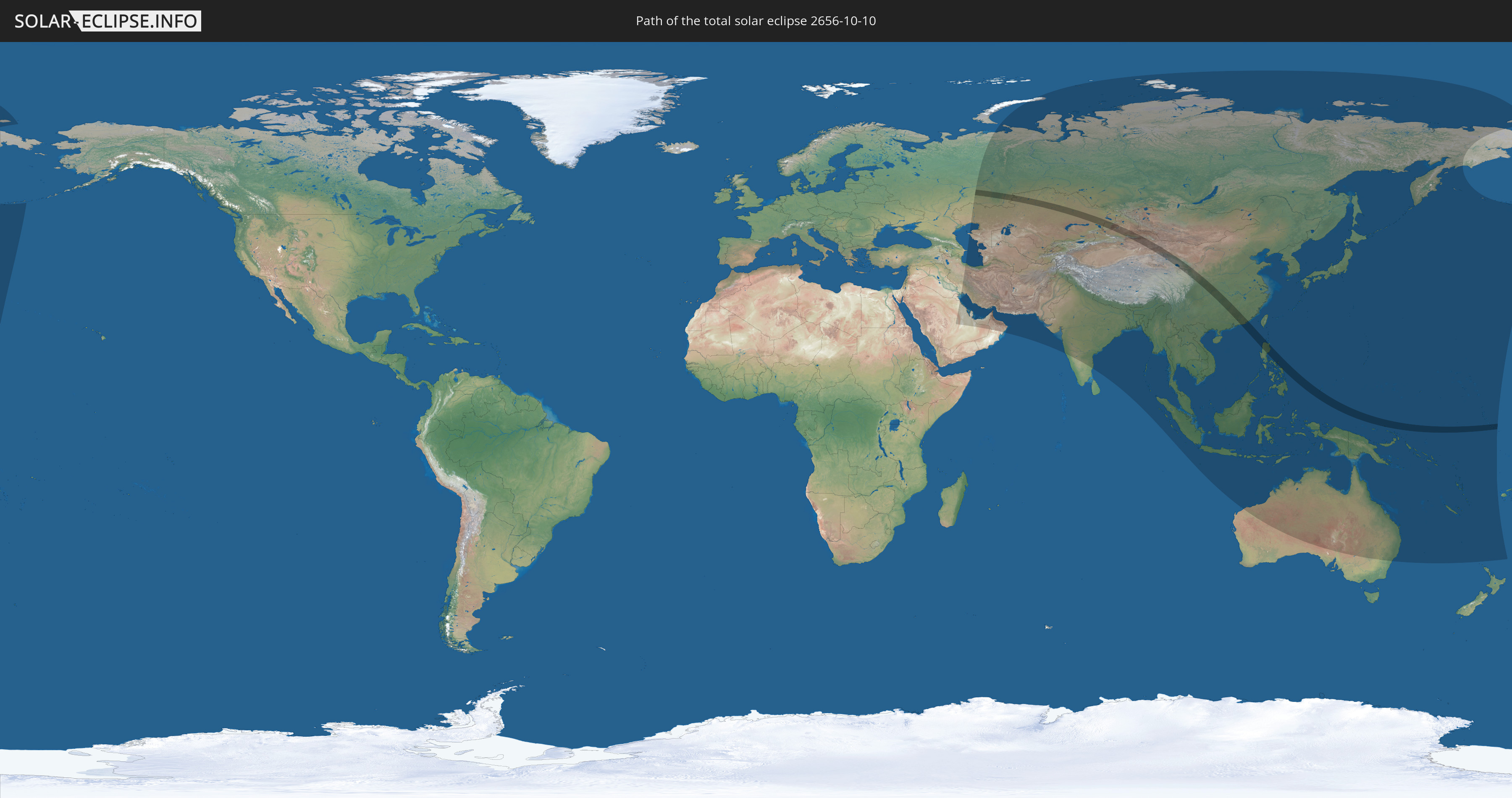
Die Sonnenfinsternis am 10/10/2656 kann man in 56 Ländern als partielle Sonnenfinsternis beobachten.
Der Finsternispfad verläuft durch 7 Länder. Nur in diesen Ländern ist sie als total Sonnenfinsternis zu sehen.
In den folgenden Ländern ist die Sonnenfinsternis total zu sehen
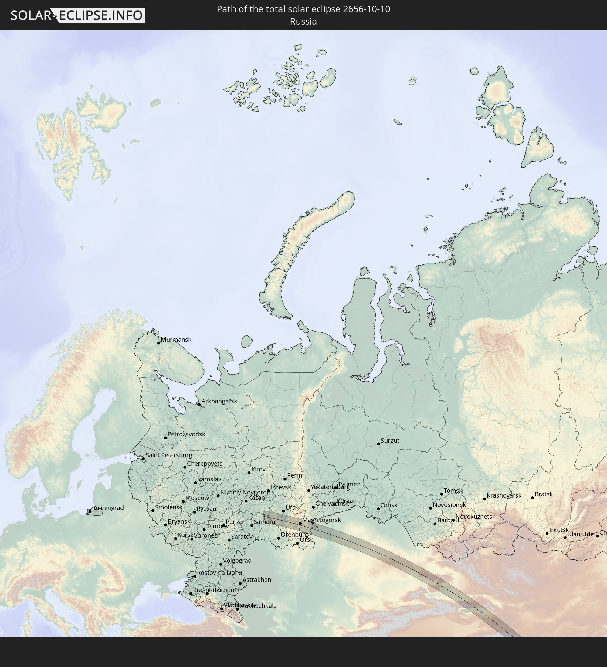 Russia
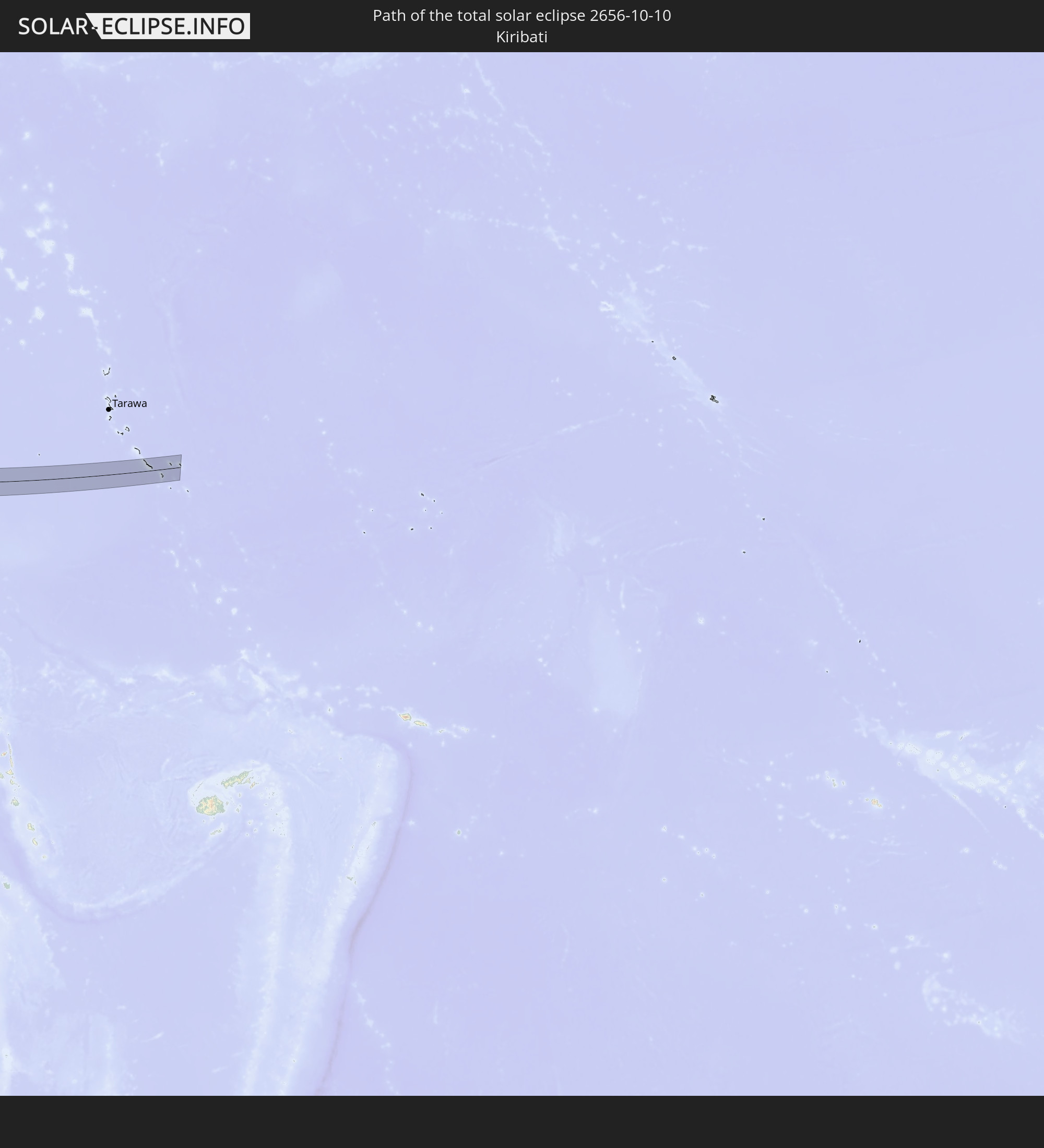 Kiribati
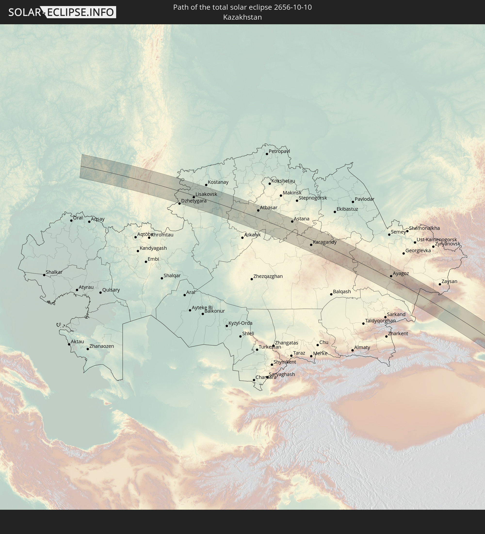 Kazakhstan
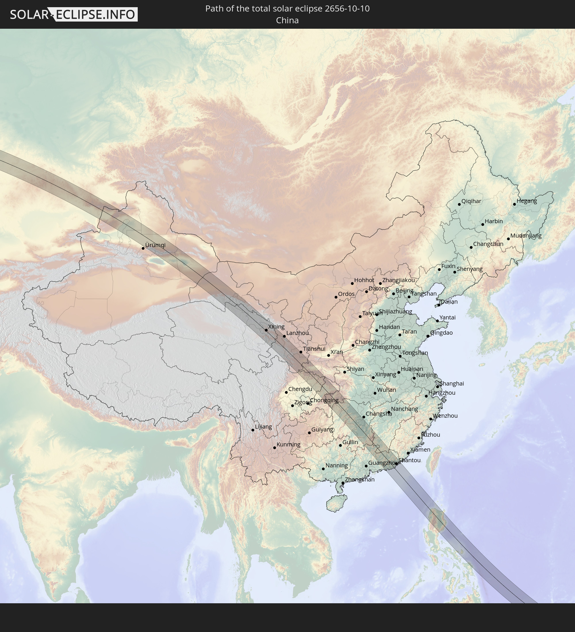 China
China
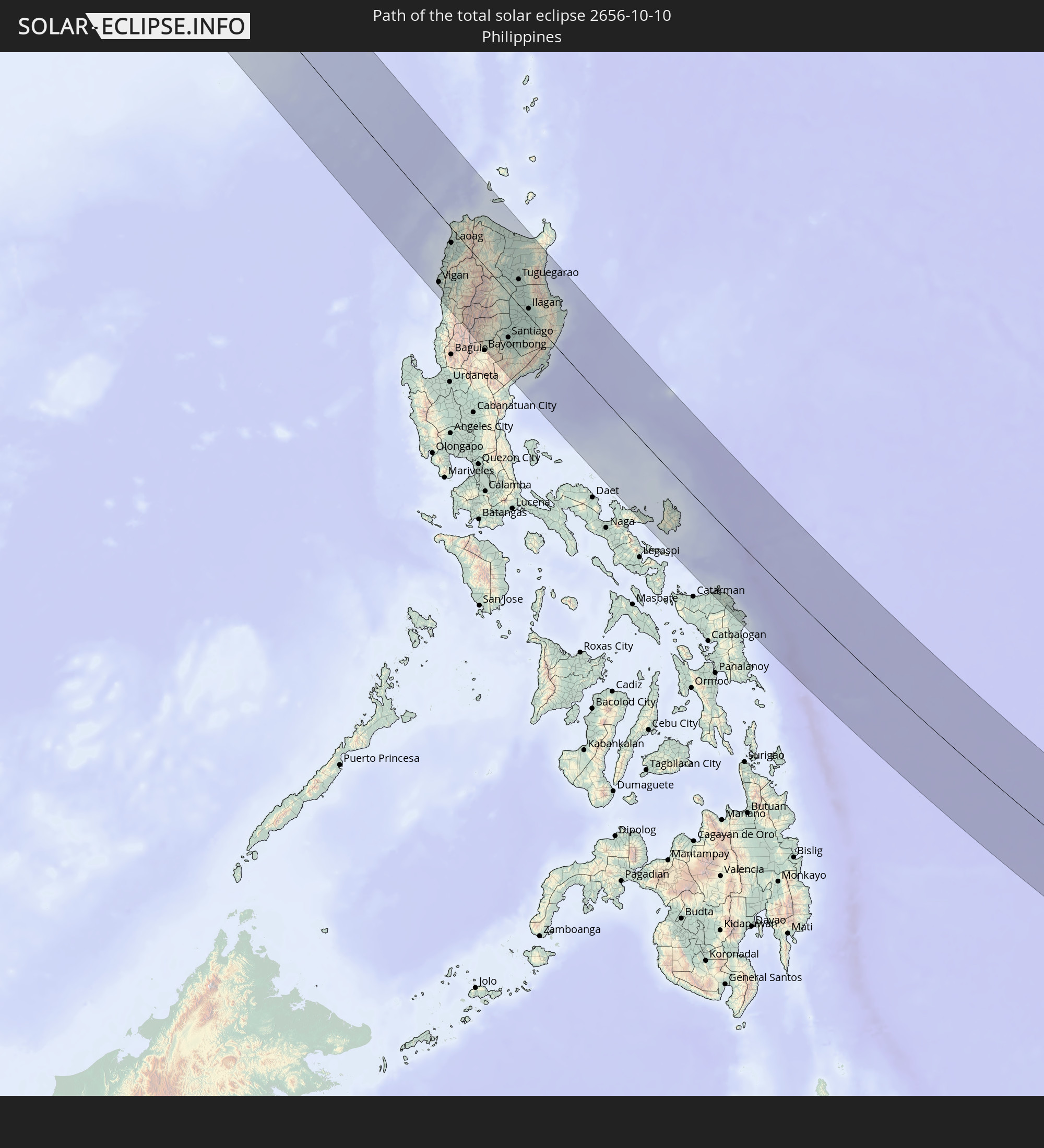 Philippines
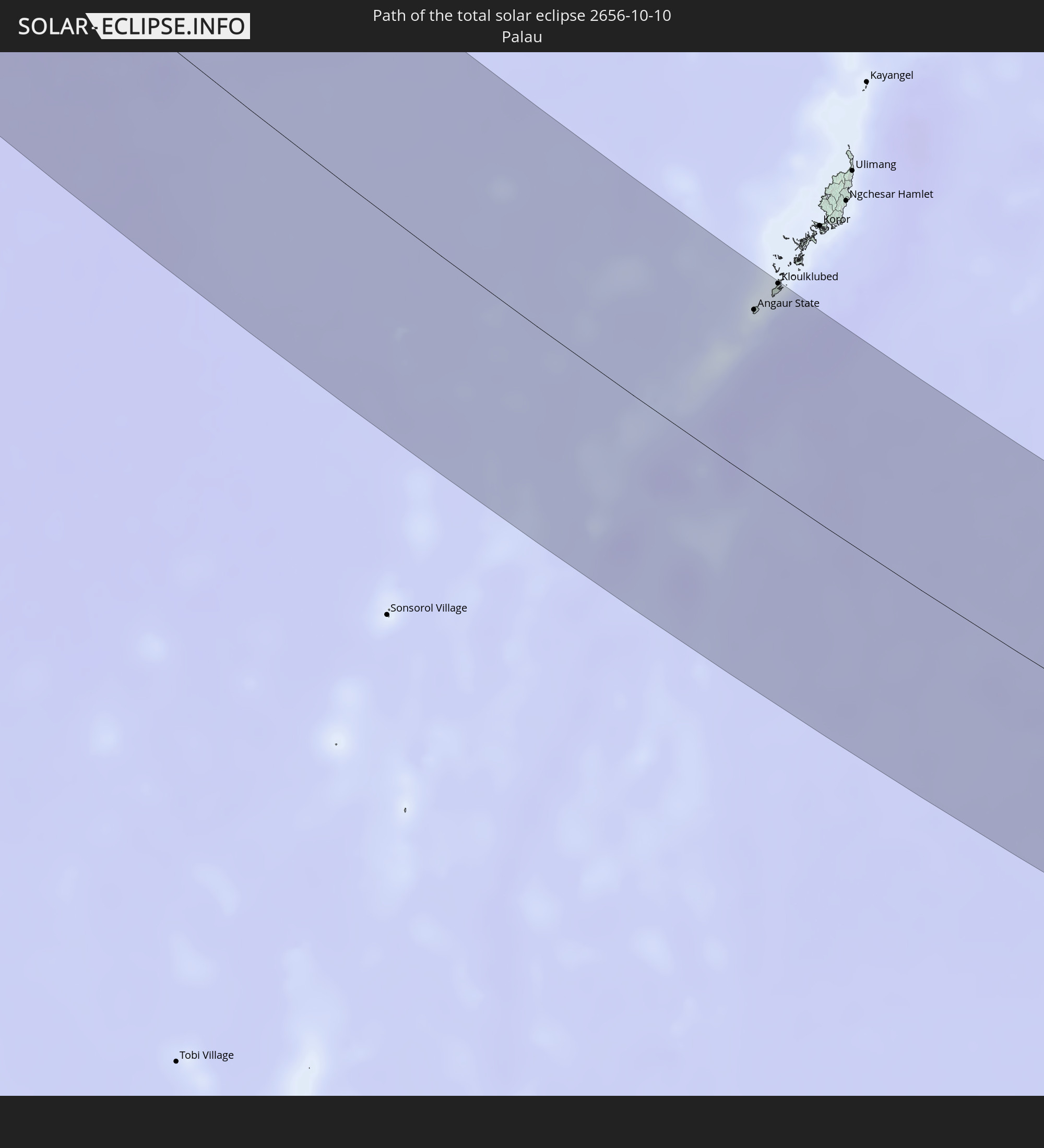 Palau
Palau
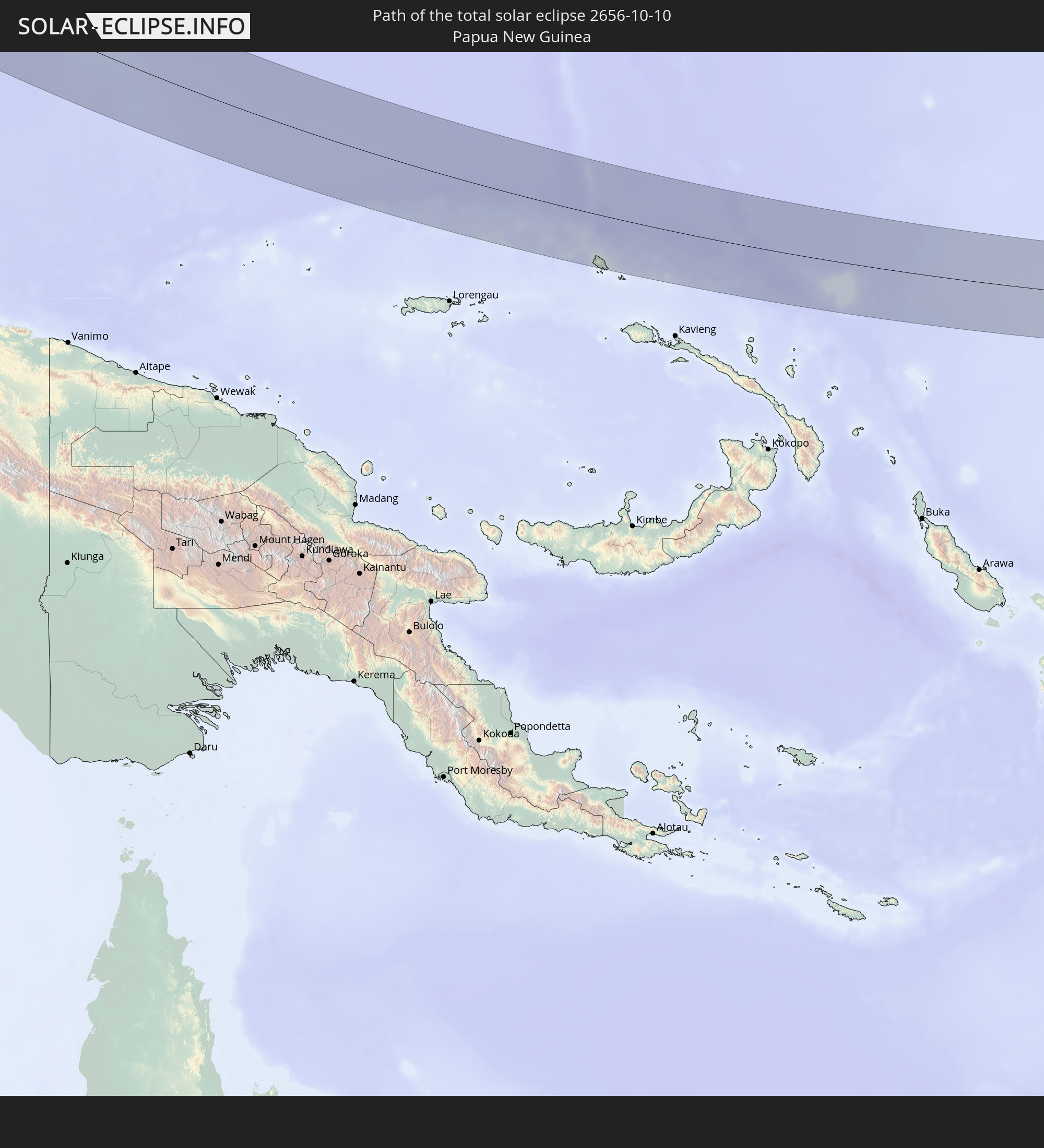 Papua New Guinea
In den folgenden Ländern ist die Sonnenfinsternis partiell zu sehen
 Russia
 United States
 United States Minor Outlying Islands
 Kiribati
 Saudi Arabia
 Iran
Iran
 Azerbaijan
 Kazakhstan
 Kuwait
 Bahrain
 Qatar
Qatar
 United Arab Emirates
 Oman
Oman
 Turkmenistan
 Uzbekistan
 Afghanistan
 Pakistan
 Tajikistan
 India
India
 Kyrgyzstan
 China
China
 Nepal
Nepal
 Mongolia
 Bangladesh
 Bhutan
 Myanmar
 Indonesia
 Thailand
 Malaysia
 Laos
Laos
 Vietnam
 Cambodia
 Singapore
 Christmas Island
 Australia
 Macau
Macau
 Hong Kong
 Brunei
 Taiwan
 Philippines
 Japan
Japan
 East Timor
 North Korea
 South Korea
 Palau
Palau
 Federated States of Micronesia
 Papua New Guinea
 Guam
Guam
 Northern Mariana Islands
 Solomon Islands
 New Caledonia
 Marshall Islands
 Vanuatu
 Nauru
Nauru
 Norfolk Island
 Tuvalu
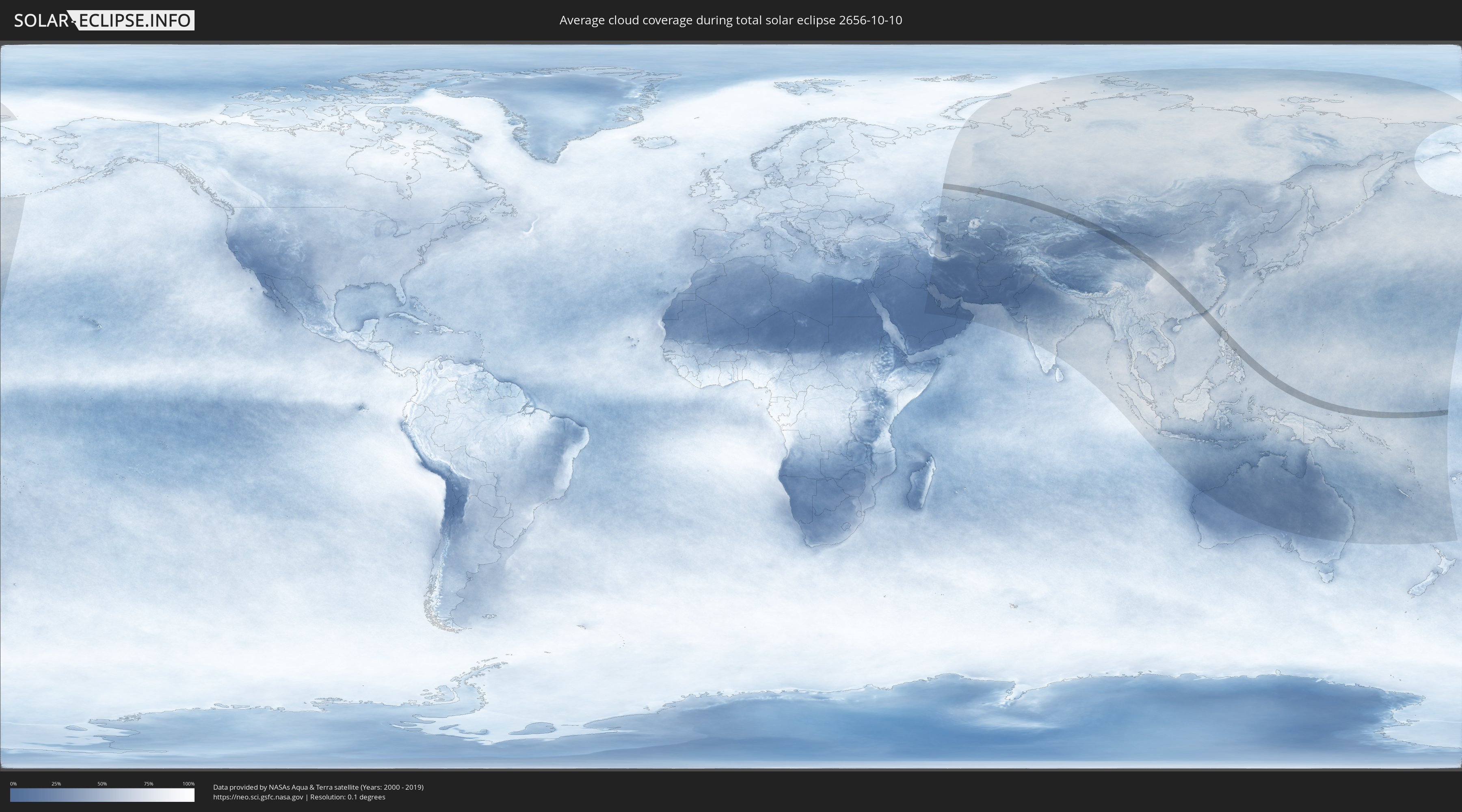
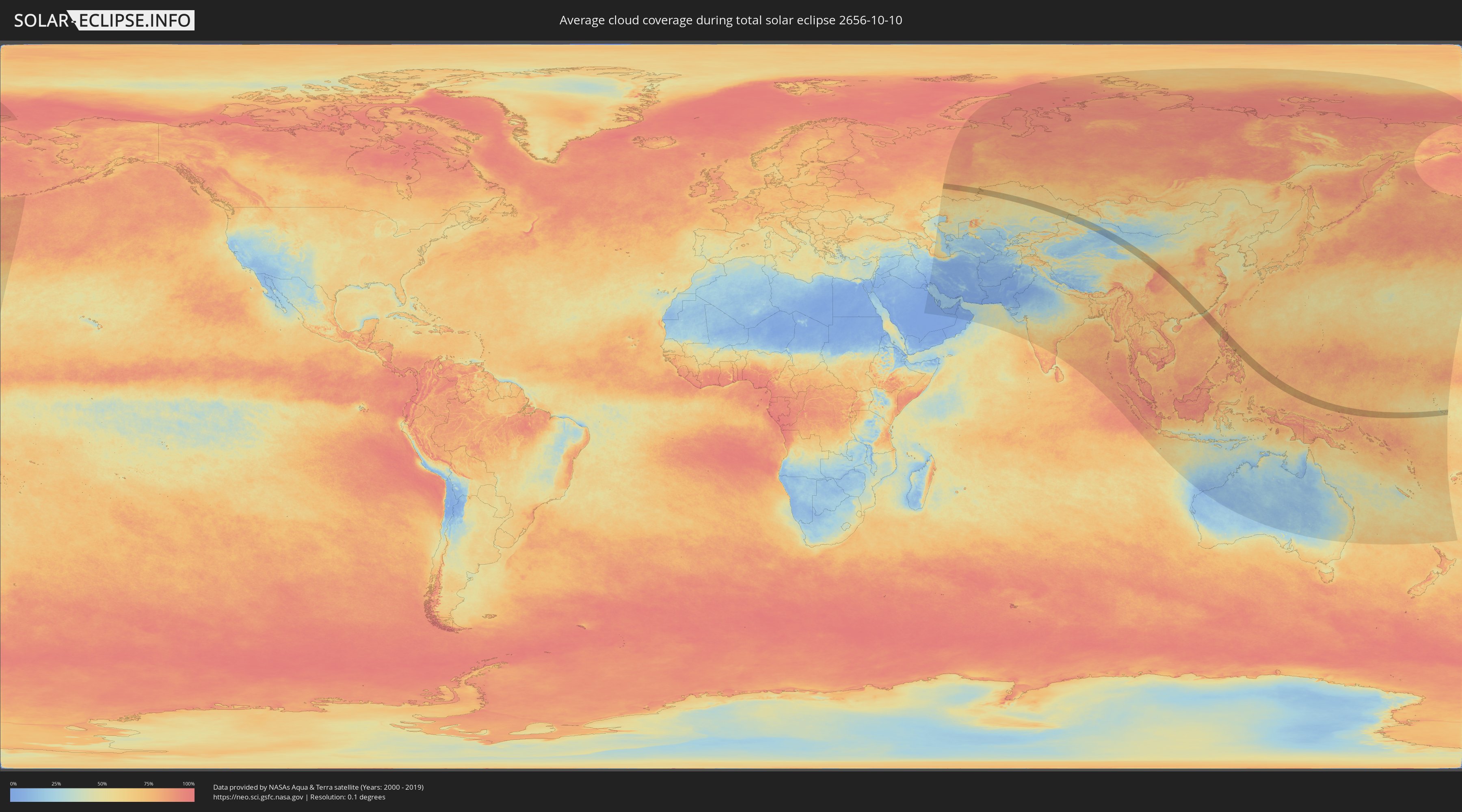
How will be the weather during the total solar eclipse on 10/10/2656?
Where is the best place to see the total solar eclipse of 10/10/2656?
The following maps show the average cloud coverage for the day of the total solar eclipse.
With the help of these maps, it is possible to find the place along the eclipse path, which has the best
chance of a cloudless sky.
Nevertheless, you should consider local circumstances and inform about the weather of your chosen
observation site.
The data is provided by NASAs satellites
AQUA and TERRA.
The cloud maps are averaged over a period of 19 years (2000 - 2019).
Detailed country maps
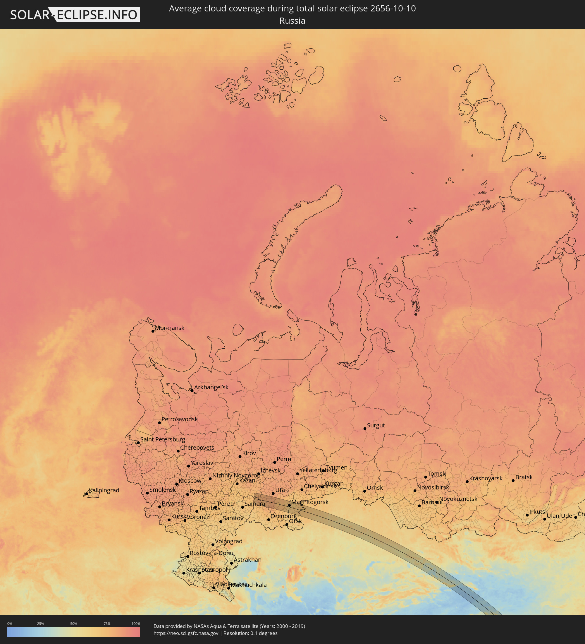 Russia
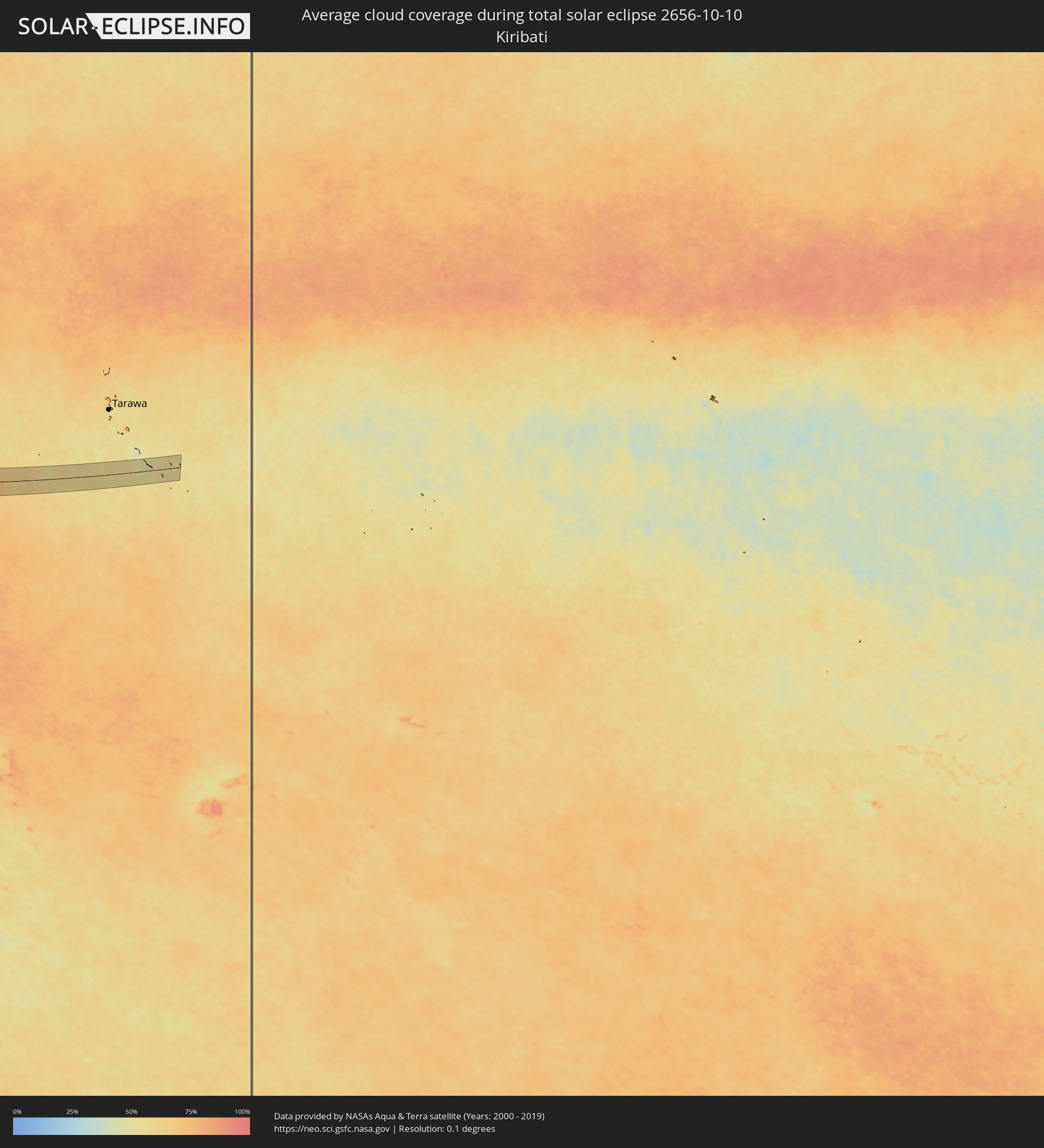 Kiribati
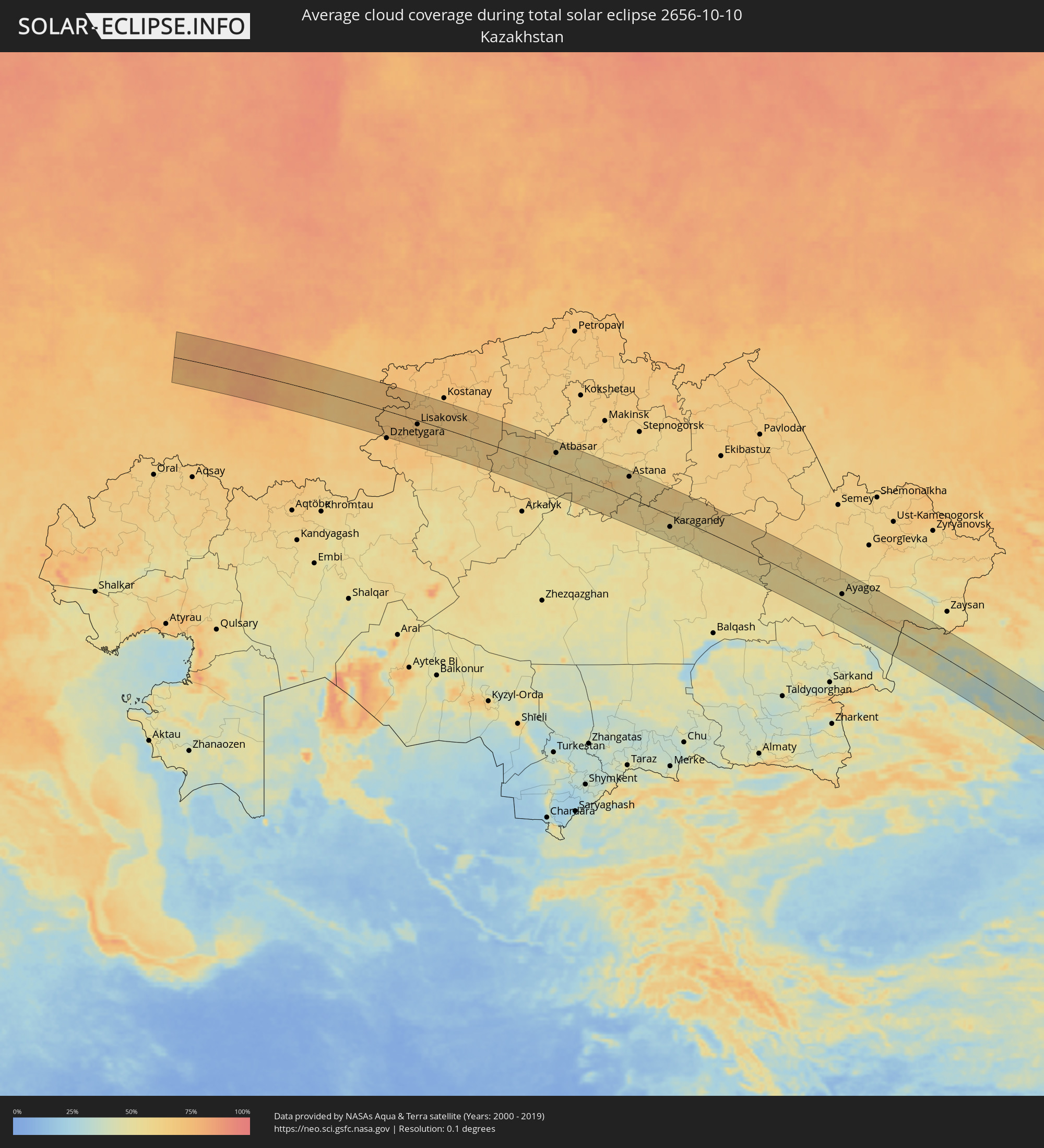 Kazakhstan
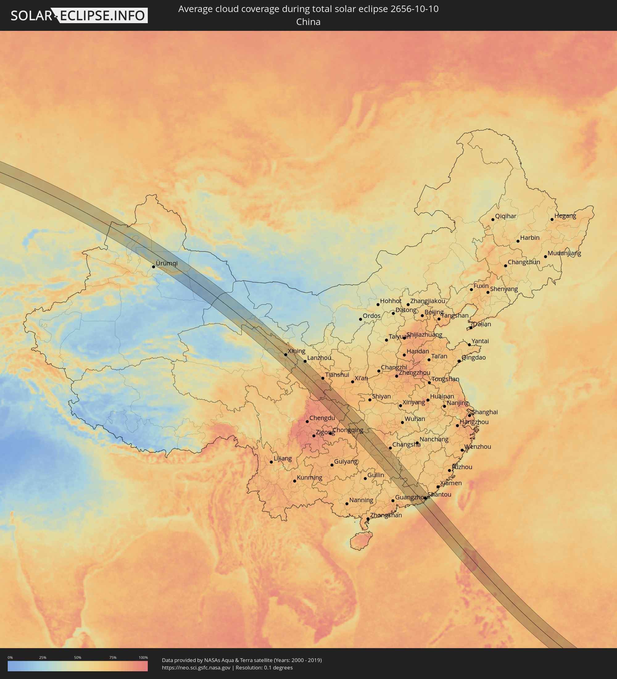 China
China
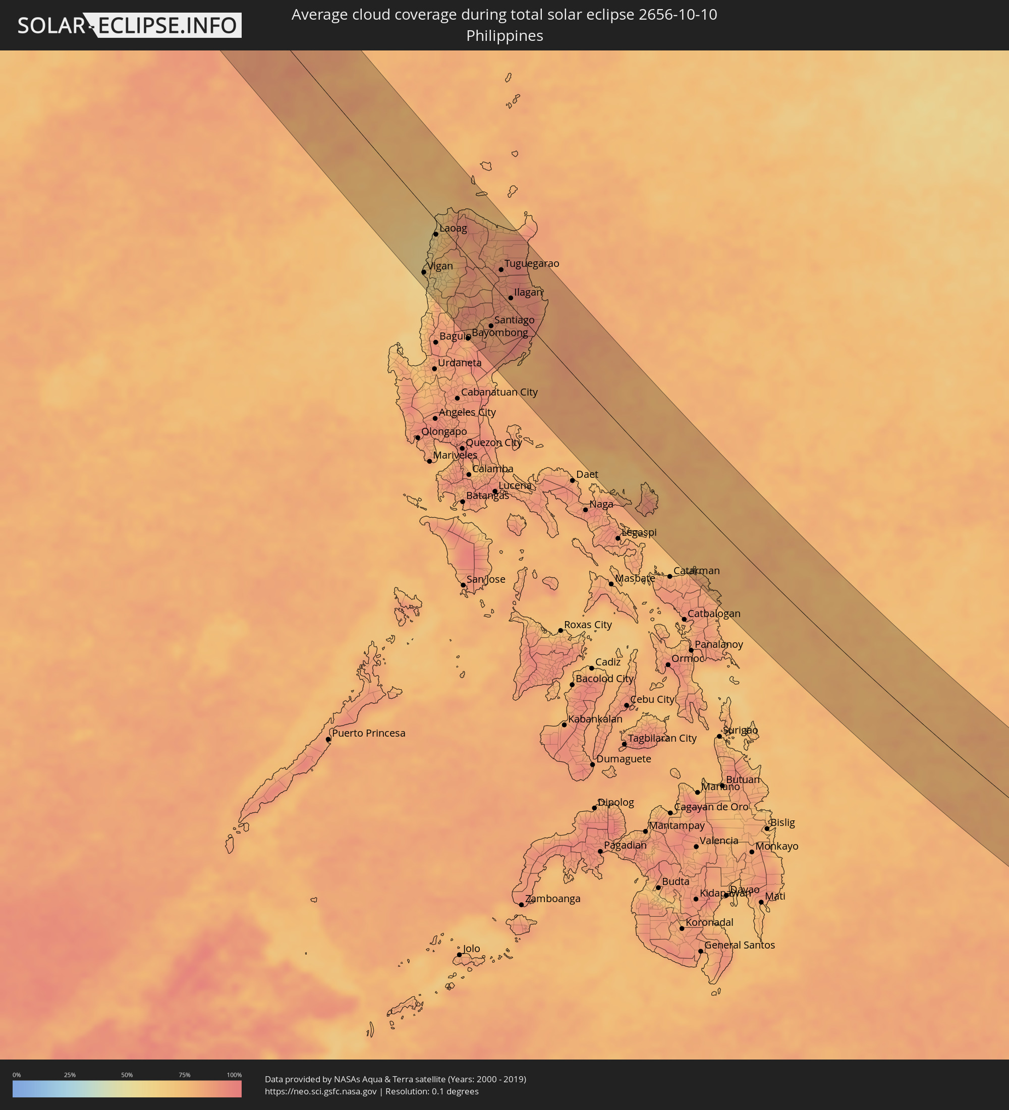 Philippines
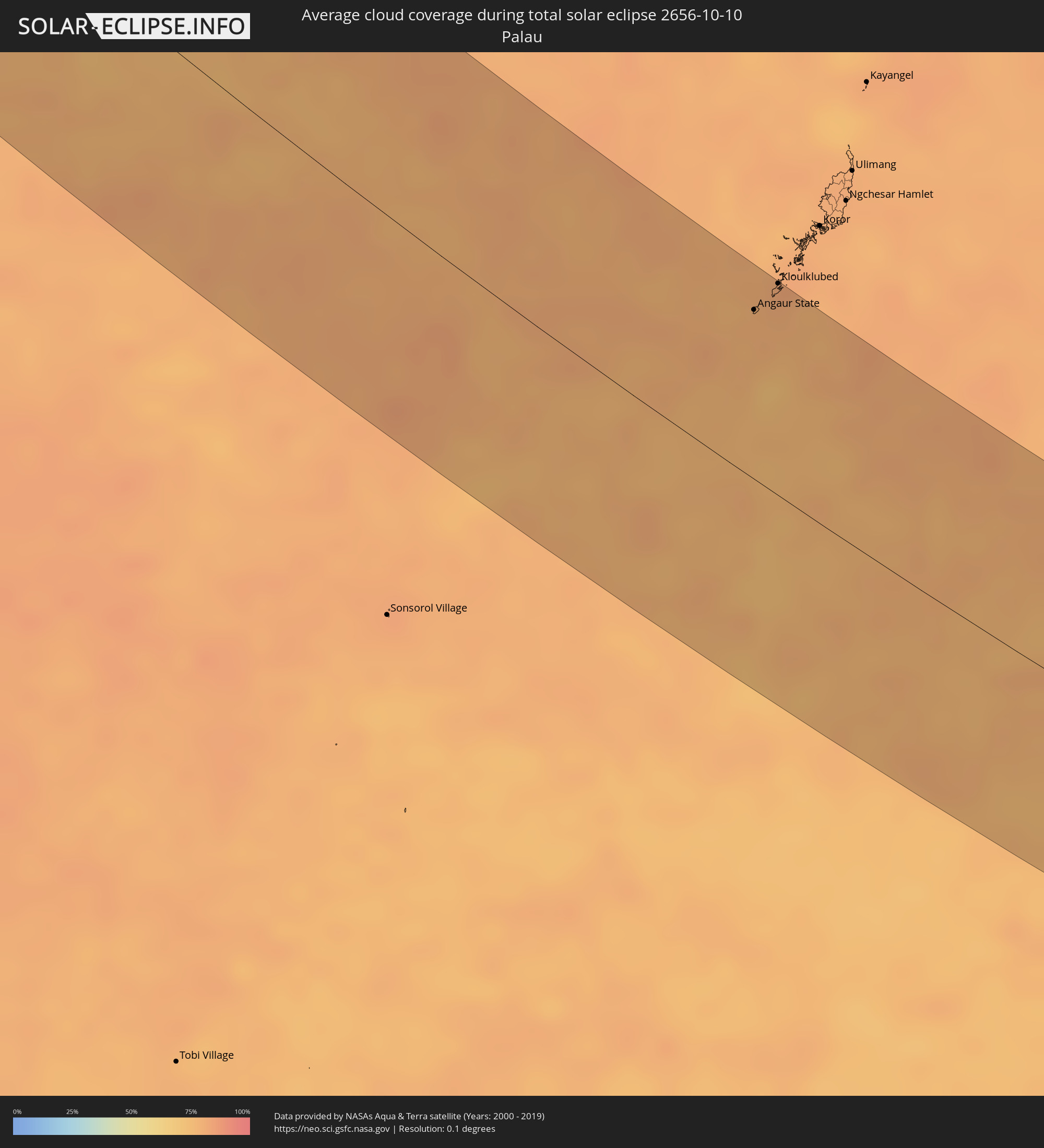 Palau
Palau
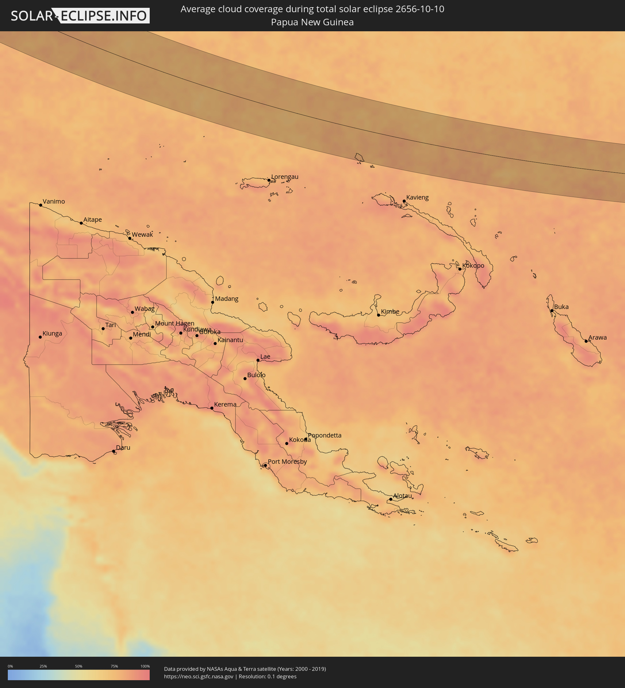 Papua New Guinea
Cities inside the path of the eclipse
The following table shows all locations with a population of more than 5,000 inside the eclipse path. Cities which have more than 100,000 inhabitants are marked bold. A click at the locations opens a detailed map.
| City | Type | Eclipse duration | Local time of max. eclipse | Distance to central line | Ø Cloud coverage |
|
Pokhvistnevo, Samara
|
total | - | 06:56:01 UTC+04:00 | 65 km | 72% |
|
Buguruslan, Orenburg
|
total | - | 07:56:03 UTC+05:00 | 61 km | 74% |
|
Leninogorsk, Tatarstan
|
total | - | 05:56:44 UTC+03:00 | 43 km | 77% |
|
Karabash, Tatarstan
|
total | - | 05:56:49 UTC+03:00 | 54 km | 77% |
|
Asekeyevo, Orenburg
|
total | - | 07:56:01 UTC+05:00 | 65 km | 76% |
|
Bugul’ma, Tatarstan
|
total | - | 05:56:43 UTC+03:00 | 40 km | 78% |
|
Bavly, Tatarstan
|
total | - | 05:56:40 UTC+03:00 | 31 km | 79% |
|
Urussu, Tatarstan
|
total | - | 05:56:50 UTC+03:00 | 56 km | 81% |
|
Oktyabr’skiy, Bashkortostan
|
total | - | 07:56:45 UTC+05:00 | 43 km | 80% |
|
Abdulino, Orenburg
|
total | - | 07:56:12 UTC+05:00 | 39 km | 76% |
|
Tuymazy, Bashkortostan
|
total | - | 07:56:52 UTC+05:00 | 60 km | 80% |
|
Serafimovskiy, Bashkortostan
|
total | - | 07:56:45 UTC+05:00 | 41 km | 79% |
|
Subkhankulovo, Bashkortostan
|
total | - | 07:56:51 UTC+05:00 | 56 km | 78% |
|
Priyutovo, Bashkortostan
|
total | - | 07:56:23 UTC+05:00 | 14 km | 79% |
|
Kandry, Bashkortostan
|
total | - | 07:56:53 UTC+05:00 | 61 km | 78% |
|
Belebey, Bashkortostan
|
total | - | 07:56:33 UTC+05:00 | 13 km | 77% |
|
Bizhbulyak, Bashkortostan
|
total | - | 07:56:16 UTC+05:00 | 31 km | 76% |
|
Buzdyak, Bashkortostan
|
total | - | 07:56:57 UTC+05:00 | 70 km | 80% |
|
Kirgiz-Miyaki, Bashkortostan
|
total | - | 07:56:18 UTC+05:00 | 30 km | 80% |
|
Rayevskiy, Bashkortostan
|
total | - | 07:56:38 UTC+05:00 | 19 km | 81% |
|
Davlekanovo, Bashkortostan
|
total | - | 07:56:45 UTC+05:00 | 37 km | 81% |
|
Sterlibashevo, Bashkortostan
|
total | - | 07:56:13 UTC+05:00 | 44 km | 83% |
|
Tolbazy, Bashkortostan
|
total | - | 07:56:44 UTC+05:00 | 29 km | 82% |
|
Salavat, Bashkortostan
|
total | - | 07:56:17 UTC+05:00 | 40 km | 80% |
|
Sterlitamak, Bashkortostan
|
total | - | 07:56:27 UTC+05:00 | 13 km | 80% |
|
Ishimbay, Bashkortostan
|
total | - | 07:56:21 UTC+05:00 | 30 km | 82% |
|
Beloretsk, Bashkortostan
|
total | - | 07:57:07 UTC+05:00 | 64 km | 73% |
|
Sibay, Bashkortostan
|
total | - | 07:56:19 UTC+05:00 | 66 km | 66% |
|
Magnitogorsk, Chelyabinsk
|
total | - | 07:56:52 UTC+05:00 | 16 km | 68% |
|
Agapovka, Chelyabinsk
|
total | - | 07:56:48 UTC+05:00 | 5 km | 66% |
|
Verkhneural’sk, Chelyabinsk
|
total | - | 07:57:13 UTC+05:00 | 68 km | 68% |
|
Bredy, Chelyabinsk
|
total | - | 07:56:29 UTC+05:00 | 67 km | 69% |
|
Lokomotivnyy, Chelyabinsk
|
total | - | 07:56:56 UTC+05:00 | 1 km | 70% |
|
Kartaly, Chelyabinsk
|
total | - | 07:56:59 UTC+05:00 | 7 km | 69% |
|
Varna, Chelyabinsk
|
total | - | 07:57:16 UTC+05:00 | 48 km | 71% |
|
Lisakovsk, Qostanay
|
total | - | 07:57:07 UTC+05:00 | 11 km | 69% |
|
Tobol, Qostanay
|
total | - | 07:57:14 UTC+05:00 | 7 km | 68% |
|
Rudnyy, Qostanay
|
total | - | 07:57:33 UTC+05:00 | 47 km | 70% |
|
Qusmuryn, Qostanay
|
total | - | 07:57:41 UTC+05:00 | 23 km | 67% |
|
Esil, Aqmola
|
total | - | 07:57:58 UTC+05:00 | 12 km | 57% |
|
Zhaqsy, Aqmola
|
total | - | 07:58:16 UTC+05:00 | 28 km | 62% |
|
Atbasar, Aqmola
|
total | - | 07:58:36 UTC+05:00 | 43 km | 52% |
|
Astrakhan, Aqmola
|
total | - | 07:59:01 UTC+05:00 | 50 km | 55% |
|
Astana, Astana Qalasy
|
total | - | 07:59:33 UTC+05:00 | 58 km | 61% |
|
Kīevka, Qaraghandy
|
total | - | 07:59:10 UTC+05:00 | 34 km | 57% |
|
Osakarovka, Qaraghandy
|
total | - | 07:59:46 UTC+05:00 | 25 km | 60% |
|
Shakhan, Qaraghandy
|
total | - | 07:59:29 UTC+05:00 | 48 km | 51% |
|
Novodolīnskīy, Qaraghandy
|
total | - | 07:59:28 UTC+05:00 | 58 km | 53% |
|
Sorang, Qaraghandy
|
total | - | 07:59:34 UTC+05:00 | 46 km | 51% |
|
Abay, Qaraghandy
|
total | - | 07:59:31 UTC+05:00 | 61 km | 53% |
|
Aqtas, Qaraghandy
|
total | - | 07:59:37 UTC+05:00 | 43 km | 54% |
|
Temirtau, Qaraghandy
|
total | - | 07:59:44 UTC+05:00 | 15 km | 58% |
|
Aqtaū, Qaraghandy
|
total | - | 07:59:52 UTC+05:00 | 6 km | 57% |
|
Karagandy, Qaraghandy
|
total | - | 07:59:45 UTC+05:00 | 32 km | 55% |
|
Qarqaraly, Qaraghandy
|
total | - | 08:00:46 UTC+05:00 | 6 km | 58% |
|
Qaraūyl, East Kazakhstan
|
total | - | 08:02:49 UTC+05:00 | 70 km | 59% |
|
Ayagoz, East Kazakhstan
|
total | - | 08:03:19 UTC+05:00 | 15 km | 52% |
|
Urzhar, East Kazakhstan
|
total | - | 08:03:57 UTC+05:00 | 27 km | 48% |
|
Baijiantan, Xinjiang Uyghur Autonomous Region
|
total | - | 11:06:24 UTC+08:00 | 28 km | 44% |
|
Laojunmiao, Gansu
|
total | - | 11:19:57 UTC+08:00 | 42 km | 32% |
|
Jiayuguan, Gansu
|
total | - | 11:20:36 UTC+08:00 | 71 km | 34% |
|
Xining, Qinghai
|
total | - | 11:26:55 UTC+08:00 | 5 km | 55% |
|
Linxia Chengguanzhen, Gansu
|
total | - | 11:29:40 UTC+08:00 | 11 km | 63% |
|
Lanzhou, Gansu
|
total | - | 11:30:08 UTC+08:00 | 87 km | 57% |
|
Guangyuan, Sichuan
|
total | - | 11:36:23 UTC+08:00 | 71 km | 83% |
|
Hanzhong, Shaanxi
|
total | - | 11:37:29 UTC+08:00 | 59 km | 83% |
|
Dazhou, Sichuan
|
total | - | 11:40:16 UTC+08:00 | 52 km | 81% |
|
Wanxian, Chongqing
|
total | - | 11:42:04 UTC+08:00 | 22 km | 76% |
|
Enshi, Hubei
|
total | - | 11:44:26 UTC+08:00 | 17 km | 70% |
|
Zhangjiajie, Hunan
|
total | - | 11:47:32 UTC+08:00 | 0 km | 71% |
|
Shangmei, Hunan
|
total | - | 11:50:46 UTC+08:00 | 44 km | 73% |
|
Lengshuijiang, Hunan
|
total | - | 11:51:04 UTC+08:00 | 38 km | 72% |
|
Changde, Hunan
|
total | - | 11:49:34 UTC+08:00 | 81 km | 78% |
|
Loudi, Hunan
|
total | - | 11:51:55 UTC+08:00 | 7 km | 71% |
|
Xiangxiang, Hunan
|
total | - | 11:52:49 UTC+08:00 | 47 km | 72% |
|
Hengyang, Hunan
|
total | - | 11:54:12 UTC+08:00 | 8 km | 73% |
|
Leiyang, Hunan
|
total | - | 11:55:19 UTC+08:00 | 26 km | 72% |
|
Xiangtan, Hunan
|
total | - | 11:53:15 UTC+08:00 | 83 km | 70% |
|
Chenzhou, Hunan
|
total | - | 11:56:32 UTC+08:00 | 57 km | 70% |
|
Lecheng, Guangdong
|
total | - | 11:58:07 UTC+08:00 | 82 km | 64% |
|
Shaoguan, Guangdong
|
total | - | 11:59:02 UTC+08:00 | 88 km | 63% |
|
Shixing, Guangdong
|
total | - | 11:59:38 UTC+08:00 | 41 km | 63% |
|
Xiongzhou, Guangdong
|
total | - | 11:59:46 UTC+08:00 | 11 km | 61% |
|
Heyuan, Guangdong
|
total | - | 12:02:40 UTC+08:00 | 82 km | 66% |
|
Donghai, Guangdong
|
total | - | 12:05:41 UTC+08:00 | 64 km | 61% |
|
Hepo, Guangdong
|
total | - | 12:05:12 UTC+08:00 | 15 km | 69% |
|
Jieshi, Guangdong
|
total | - | 12:06:15 UTC+08:00 | 59 km | 50% |
|
Jiazi, Guangdong
|
total | - | 12:06:33 UTC+08:00 | 36 km | 57% |
|
Meizhou, Guangdong
|
total | - | 12:04:15 UTC+08:00 | 69 km | 67% |
|
Puning, Guangdong
|
total | - | 12:06:00 UTC+08:00 | 3 km | 74% |
|
Huicheng, Guangdong
|
total | - | 12:06:40 UTC+08:00 | 7 km | 59% |
|
Jieyang, Guangdong
|
total | - | 12:05:58 UTC+08:00 | 35 km | 70% |
|
Haimen, Guangdong
|
total | - | 12:06:59 UTC+08:00 | 29 km | 58% |
|
Chaozhou, Guangdong
|
total | - | 12:06:14 UTC+08:00 | 63 km | 71% |
|
Anbu, Guangdong
|
total | - | 12:06:41 UTC+08:00 | 53 km | 64% |
|
Shantou, Guangdong
|
total | - | 12:06:52 UTC+08:00 | 50 km | 64% |
|
Chenghua, Guangdong
|
total | - | 12:06:49 UTC+08:00 | 61 km | 62% |
|
Huanggang, Guangdong
|
total | - | 12:06:52 UTC+08:00 | 94 km | 67% |
|
Vigan, Ilocos
|
total | - | 12:24:03 UTC+08:00 | 79 km | 65% |
|
Cabugao, Ilocos
|
total | - | 12:23:47 UTC+08:00 | 58 km | 75% |
|
Batac City, Ilocos
|
total | - | 12:23:29 UTC+08:00 | 30 km | 64% |
|
Laoag, Ilocos
|
total | - | 12:23:16 UTC+08:00 | 17 km | 66% |
|
Dingras, Ilocos
|
total | - | 12:23:38 UTC+08:00 | 16 km | 73% |
|
Bontoc, Cordillera
|
total | - | 12:26:06 UTC+08:00 | 68 km | 80% |
|
Claveria, Cagayan Valley
|
total | - | 12:23:25 UTC+08:00 | 52 km | 82% |
|
Lagawe, Cordillera
|
total | - | 12:26:55 UTC+08:00 | 78 km | 84% |
|
Pasil, Cordillera
|
total | - | 12:25:49 UTC+08:00 | 34 km | 84% |
|
Solano, Cagayan Valley
|
total | - | 12:27:34 UTC+08:00 | 94 km | 84% |
|
Diadi, Cagayan Valley
|
total | - | 12:27:31 UTC+08:00 | 65 km | 83% |
|
Tabuk, Cordillera
|
total | - | 12:26:17 UTC+08:00 | 1 km | 82% |
|
Cabaritan East, Cagayan Valley
|
total | - | 12:24:32 UTC+08:00 | 70 km | 76% |
|
Cabarroguis, Cagayan Valley
|
total | - | 12:28:14 UTC+08:00 | 68 km | 83% |
|
Santiago, Cagayan Valley
|
total | - | 12:27:56 UTC+08:00 | 52 km | 84% |
|
Saguday, Cagayan Valley
|
total | - | 12:28:15 UTC+08:00 | 62 km | 84% |
|
San Mateo, Cagayan Valley
|
total | - | 12:27:38 UTC+08:00 | 35 km | 88% |
|
Batal, Cagayan Valley
|
total | - | 12:28:02 UTC+08:00 | 48 km | 84% |
|
Quezon, Cagayan Valley
|
total | - | 12:26:51 UTC+08:00 | 2 km | 84% |
|
Salinungan Proper, Cagayan Valley
|
total | - | 12:27:43 UTC+08:00 | 34 km | 88% |
|
Roxas, Cagayan Valley
|
total | - | 12:27:15 UTC+08:00 | 15 km | 86% |
|
Aparri, Cagayan Valley
|
total | - | 12:24:56 UTC+08:00 | 78 km | 73% |
|
Echague, Cagayan Valley
|
total | - | 12:28:09 UTC+08:00 | 41 km | 84% |
|
Magapit, Aguiguican, Cagayan Valley
|
total | - | 12:25:28 UTC+08:00 | 63 km | 83% |
|
Bauan, Cagayan Valley
|
total | - | 12:26:13 UTC+08:00 | 35 km | 87% |
|
Maddela, Cagayan Valley
|
total | - | 12:28:52 UTC+08:00 | 67 km | 85% |
|
Alicia, Cagayan Valley
|
total | - | 12:28:03 UTC+08:00 | 34 km | 83% |
|
Burgos, Cagayan Valley
|
total | - | 12:27:28 UTC+08:00 | 10 km | 88% |
|
Tuguegarao, Cagayan Valley
|
total | - | 12:26:30 UTC+08:00 | 30 km | 85% |
|
Minante Segundo, Cagayan Valley
|
total | - | 12:27:56 UTC+08:00 | 19 km | 83% |
|
Cabagan, Cagayan Valley
|
total | - | 12:26:56 UTC+08:00 | 20 km | 87% |
|
Naguilian, Cagayan Valley
|
total | - | 12:27:51 UTC+08:00 | 5 km | 84% |
|
Ilagan, Cagayan Valley
|
total | - | 12:27:42 UTC+08:00 | 9 km | 84% |
|
San Mariano, Cagayan Valley
|
total | - | 12:28:15 UTC+08:00 | 7 km | 88% |
|
Calatagan, Bicol
|
total | - | 12:39:02 UTC+08:00 | 77 km | 80% |
|
Virac, Bicol
|
total | - | 12:39:06 UTC+08:00 | 74 km | 80% |
|
Laoang, Eastern Visayas
|
total | - | 12:42:35 UTC+08:00 | 93 km | 76% |
|
Palapag, Eastern Visayas
|
total | - | 12:42:50 UTC+08:00 | 87 km | 83% |
|
Gamay, Eastern Visayas
|
total | - | 12:43:29 UTC+08:00 | 86 km | 77% |
|
Dolores, Eastern Visayas
|
total | - | 12:44:32 UTC+08:00 | 99 km | 75% |
|
Angaur State, Angaur
|
total | - | 14:10:31 UTC+09:00 | 80 km | 78% |
|
Kloulklubed, Peleliu
|
total | - | 14:10:29 UTC+09:00 | 101 km | 80% |