Annular solar eclipse of 03/16/2667
| Day of week: | Saturday |
| Maximum duration of eclipse: | 05m36s |
| Maximum width of eclipse path: | 203 km |
| Saros cycle: | 150 |
| Coverage: | 95.1% |
| Magnitude: | 0.9506 |
| Gamma: | 0.4613 |
Wo kann man die Sonnenfinsternis vom 03/16/2667 sehen?
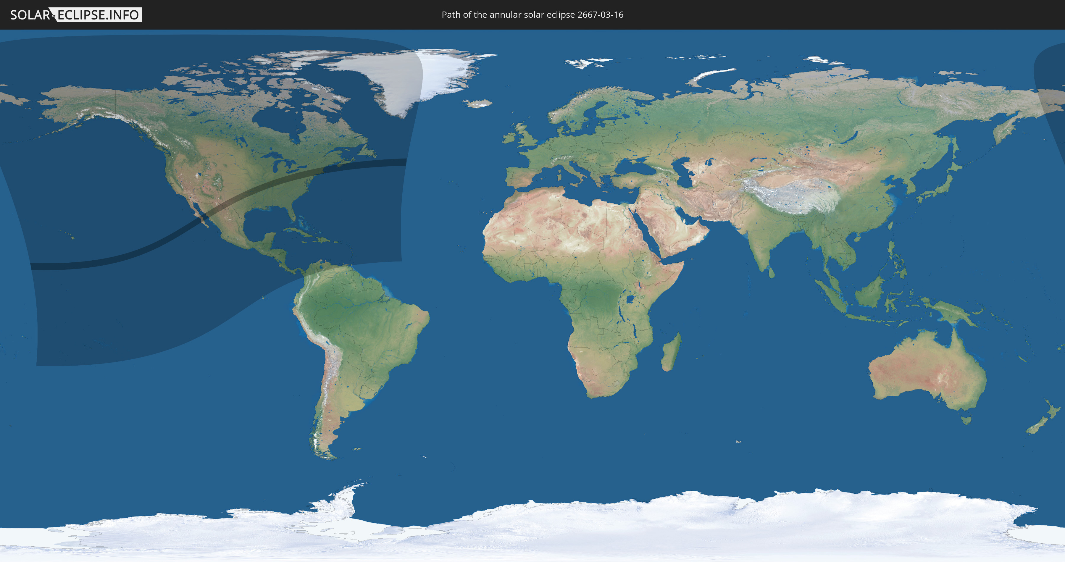
Die Sonnenfinsternis am 03/16/2667 kann man in 46 Ländern als partielle Sonnenfinsternis beobachten.
Der Finsternispfad verläuft durch 3 Länder. Nur in diesen Ländern ist sie als annular Sonnenfinsternis zu sehen.
In den folgenden Ländern ist die Sonnenfinsternis annular zu sehen
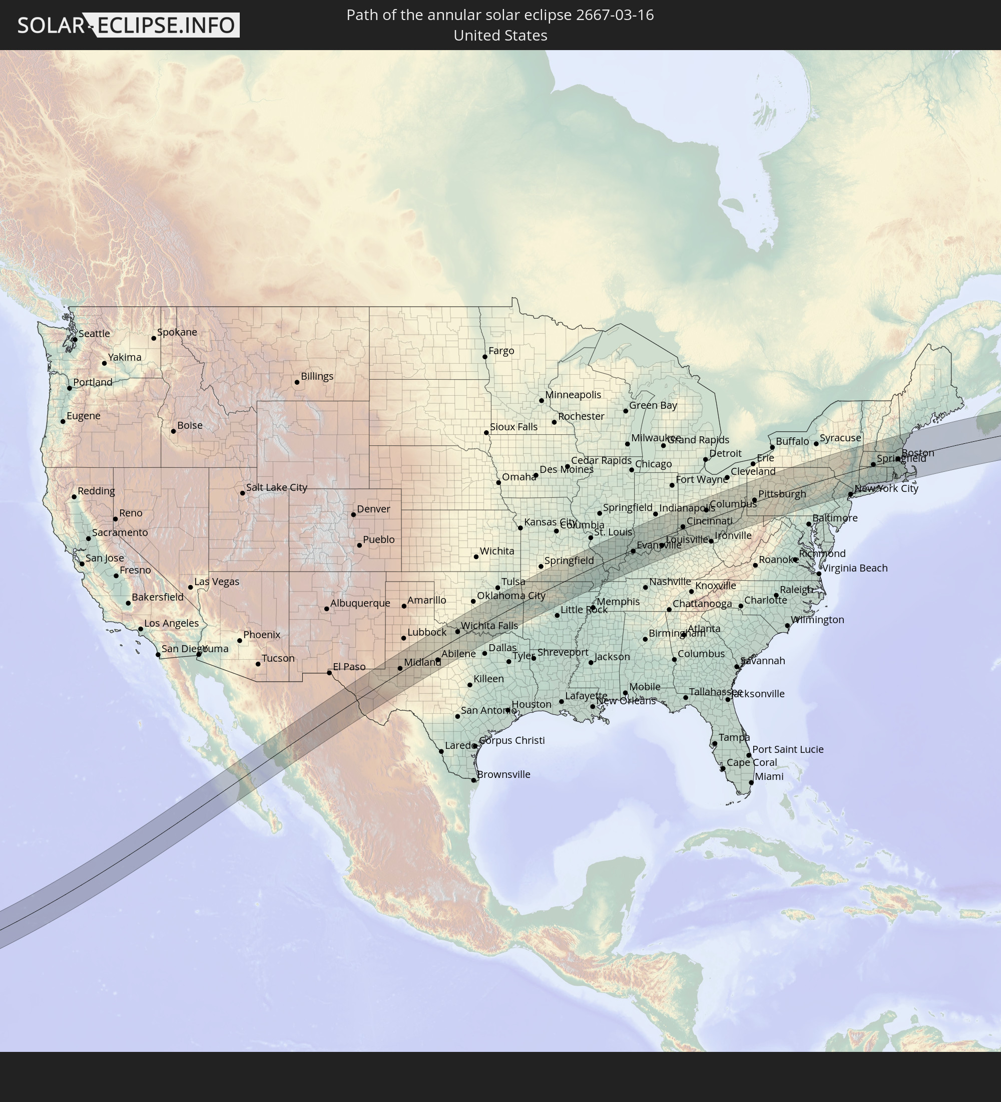 United States
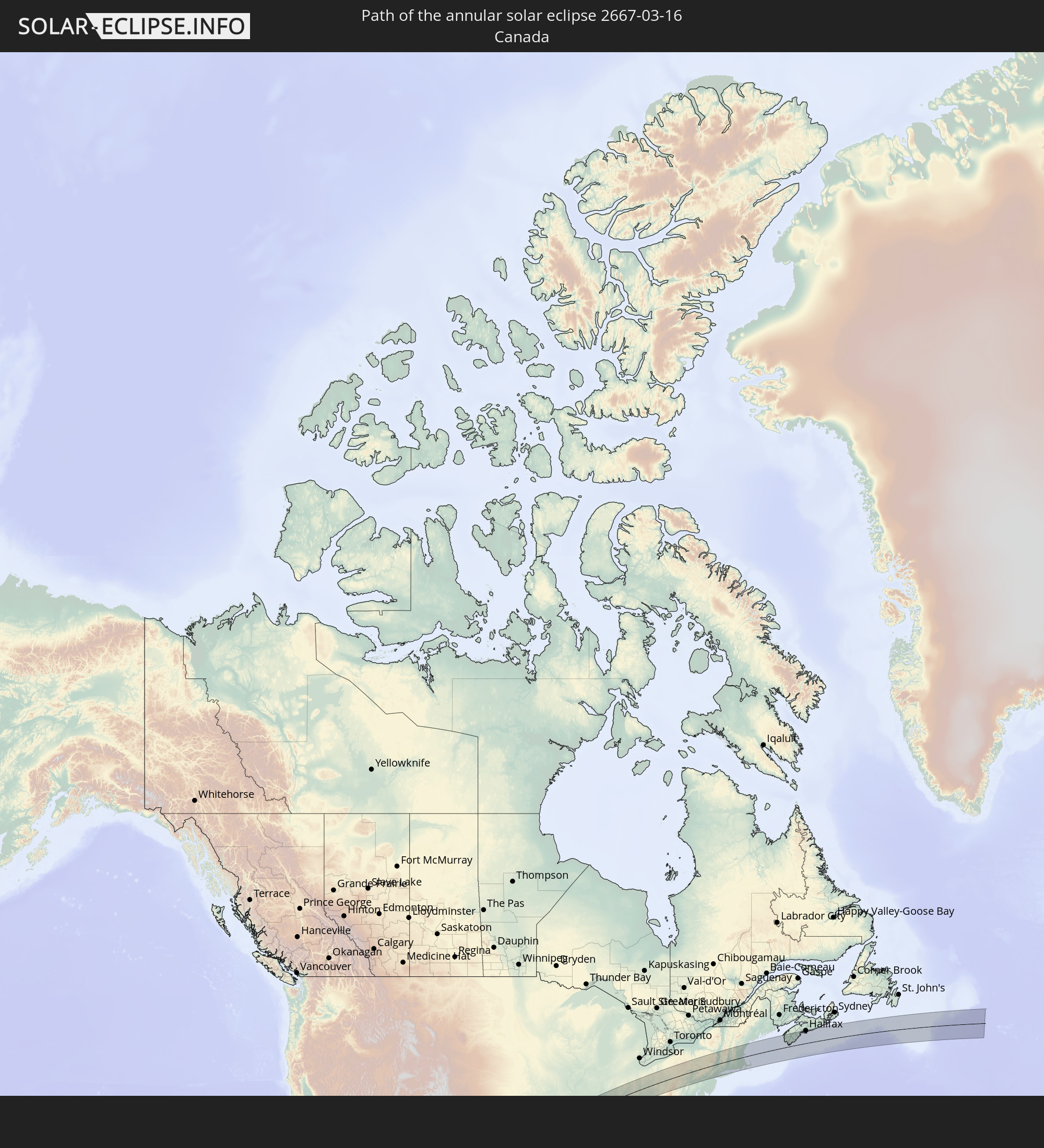 Canada
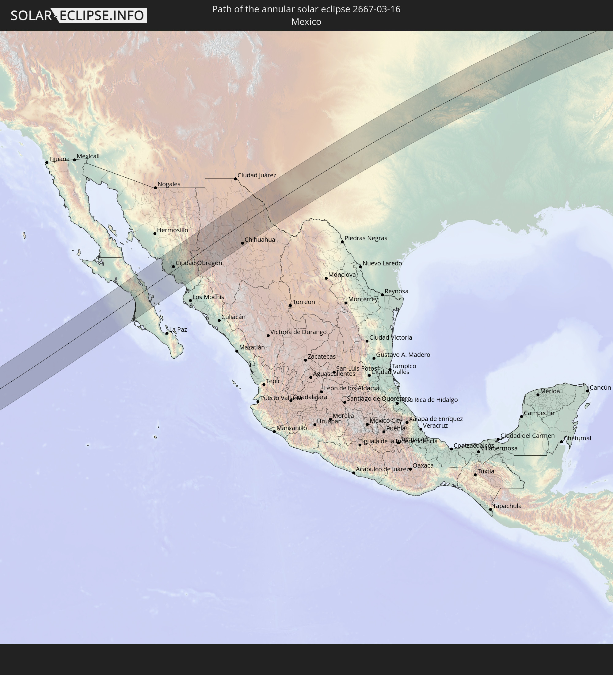 Mexico
In den folgenden Ländern ist die Sonnenfinsternis partiell zu sehen
 Russia
 United States
 United States Minor Outlying Islands
 Kiribati
 Cook Islands
 French Polynesia
 Canada
 Mexico
 Greenland
 Guatemala
 Ecuador
 El Salvador
 Honduras
 Belize
 Nicaragua
 Costa Rica
 Cuba
Cuba
 Panama
 Colombia
 Cayman Islands
 The Bahamas
 Jamaica
 Haiti
Haiti
 Venezuela
 Turks and Caicos Islands
 Dominican Republic
 Aruba
Aruba
 Puerto Rico
 United States Virgin Islands
 Bermuda
 British Virgin Islands
 Anguilla
 Collectivity of Saint Martin
 Saint Barthélemy
 Saint Kitts and Nevis
 Antigua and Barbuda
 Montserrat
 Trinidad and Tobago
 Guadeloupe
 Grenada
 Dominica
 Saint Vincent and the Grenadines
 Martinique
 Saint Lucia
 Barbados
 Saint Pierre and Miquelon
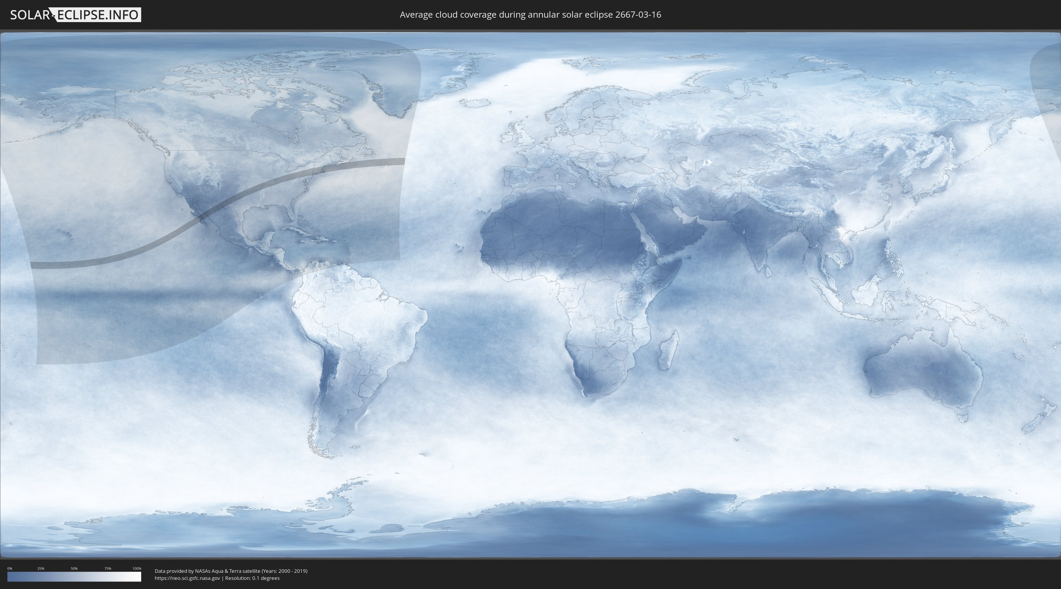
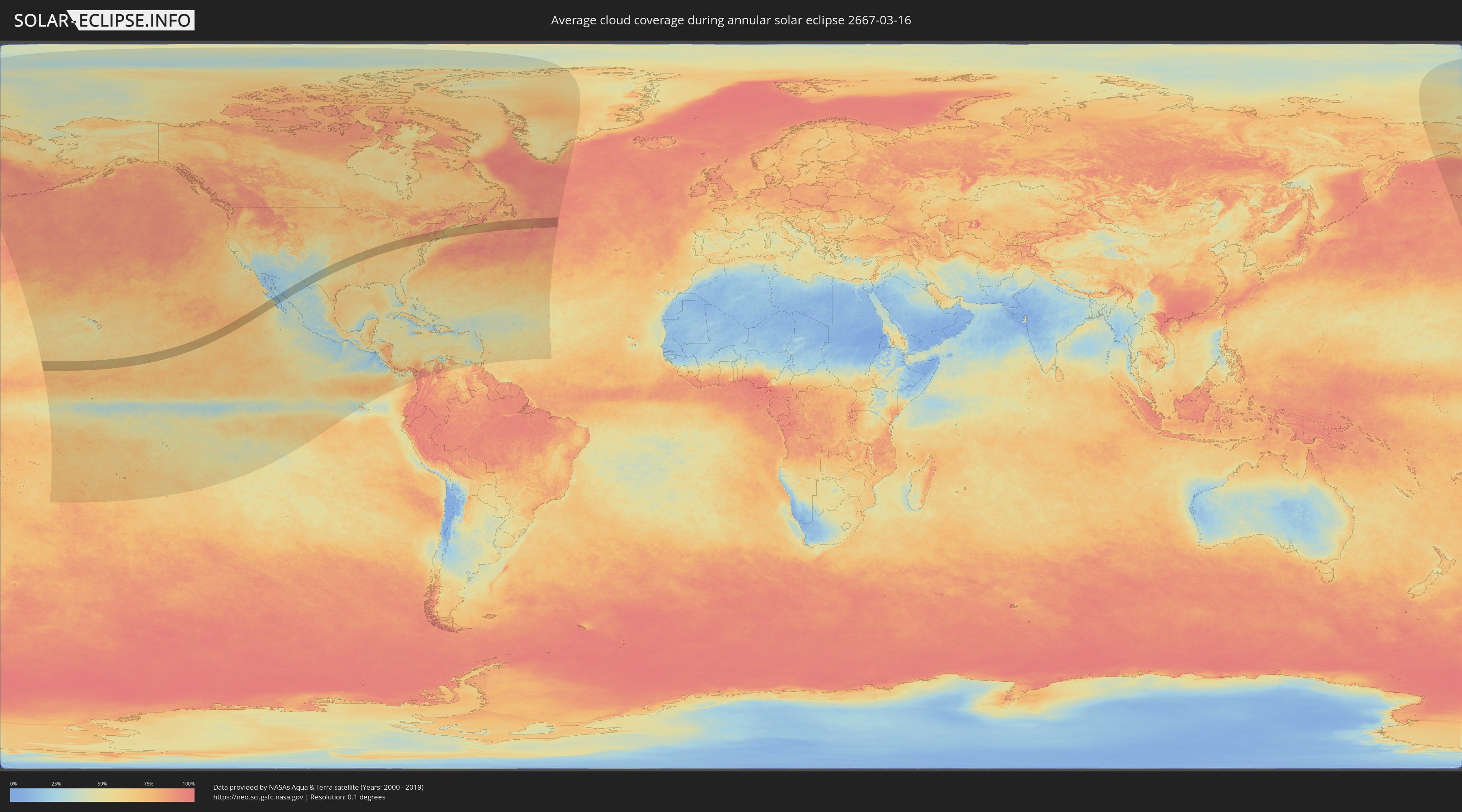
How will be the weather during the annular solar eclipse on 03/16/2667?
Where is the best place to see the annular solar eclipse of 03/16/2667?
The following maps show the average cloud coverage for the day of the annular solar eclipse.
With the help of these maps, it is possible to find the place along the eclipse path, which has the best
chance of a cloudless sky.
Nevertheless, you should consider local circumstances and inform about the weather of your chosen
observation site.
The data is provided by NASAs satellites
AQUA and TERRA.
The cloud maps are averaged over a period of 19 years (2000 - 2019).
Detailed country maps
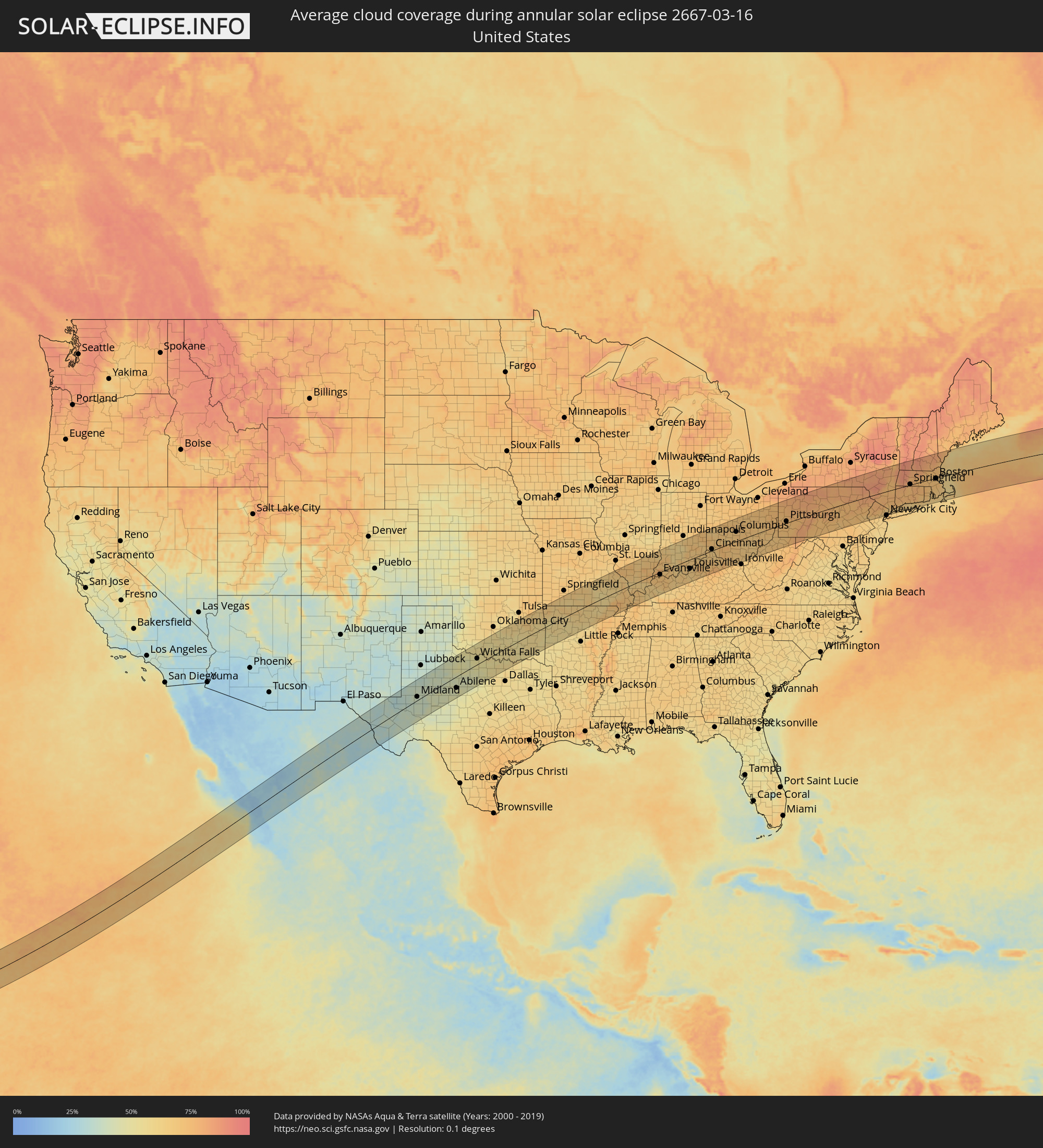 United States
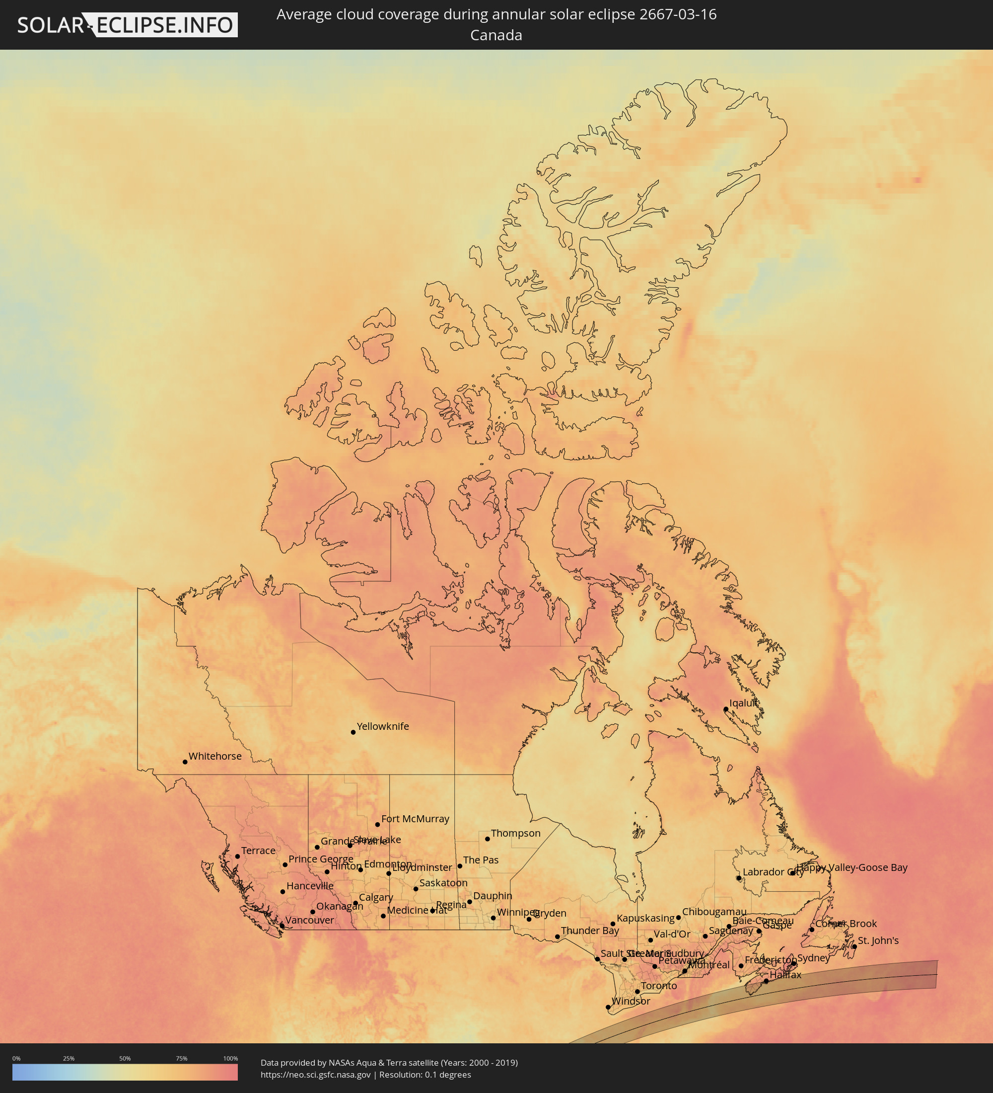 Canada
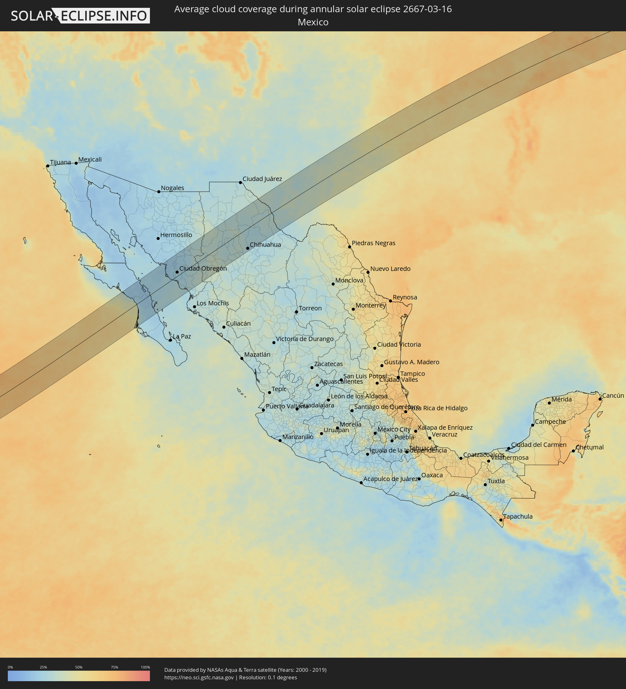 Mexico
Cities inside the path of the eclipse
The following table shows all locations with a population of more than 5,000 inside the eclipse path. Cities which have more than 100,000 inhabitants are marked bold. A click at the locations opens a detailed map.
| City | Type | Eclipse duration | Local time of max. eclipse | Distance to central line | Ø Cloud coverage |
|
Ciudad Insurgentes, Baja California Sur
|
annular | - | 12:17:34 UTC-07:00 | 84 km | 25% |
|
Loreto, Baja California Sur
|
annular | - | 12:19:57 UTC-07:00 | 39 km | 25% |
|
Potam, Sonora
|
annular | - | 12:24:58 UTC-07:00 | 56 km | 20% |
|
Vicam, Sonora
|
annular | - | 12:25:18 UTC-07:00 | 51 km | 21% |
|
San Ignacio Río Muerto, Sonora
|
annular | - | 12:25:05 UTC-07:00 | 27 km | 22% |
|
Campo Sesenta, Sonora
|
annular | - | 12:25:31 UTC-07:00 | 22 km | 24% |
|
Pueblo Yaqui, Sonora
|
annular | - | 12:25:32 UTC-07:00 | 10 km | 24% |
|
Cocorit, Sonora
|
annular | - | 12:26:04 UTC-07:00 | 26 km | 26% |
|
Ciudad Obregón, Sonora
|
annular | - | 12:25:59 UTC-07:00 | 16 km | 26% |
|
El Tobarito, Sonora
|
annular | - | 12:25:56 UTC-07:00 | 3 km | 26% |
|
Marte R. Gómez (Tobarito), Sonora
|
annular | - | 12:25:57 UTC-07:00 | 2 km | 26% |
|
Villa Juarez, Sonora
|
annular | - | 12:25:42 UTC-07:00 | 22 km | 24% |
|
Bacobampo, Sonora
|
annular | - | 12:25:58 UTC-07:00 | 46 km | 26% |
|
Huatabampo, Sonora
|
annular | - | 12:25:45 UTC-07:00 | 61 km | 28% |
|
Etchojoa, Sonora
|
annular | - | 12:25:55 UTC-07:00 | 54 km | 28% |
|
La Unión, Sonora
|
annular | - | 12:25:49 UTC-07:00 | 63 km | 28% |
|
Navojoa, Sonora
|
annular | - | 12:26:38 UTC-07:00 | 50 km | 28% |
|
Alamos, Sonora
|
annular | - | 12:27:54 UTC-07:00 | 82 km | 32% |
|
San Pedro Madera, Chihuahua
|
annular | - | 12:33:04 UTC-07:00 | 74 km | 32% |
|
Creel, Chihuahua
|
annular | - | 12:32:21 UTC-07:00 | 87 km | 34% |
|
Buenaventura, Chihuahua
|
annular | - | 12:35:40 UTC-07:00 | 96 km | 31% |
|
Adolfo López Mateos, Chihuahua
|
annular | - | 12:34:13 UTC-07:00 | 40 km | 28% |
|
Ejido Benito Juárez, Chihuahua
|
annular | - | 12:37:30 UTC-07:00 | 93 km | 31% |
|
Cuauhtémoc, Chihuahua
|
annular | - | 12:35:15 UTC-07:00 | 69 km | 29% |
|
Anáhuac, Chihuahua
|
annular | - | 12:35:39 UTC-07:00 | 68 km | 32% |
|
Chihuahua, Chihuahua
|
annular | - | 12:37:31 UTC-07:00 | 90 km | 28% |
|
Ojinaga, Chihuahua
|
annular | - | 12:42:34 UTC-07:00 | 85 km | 28% |
|
Manuel Ojinaga, Chihuahua
|
annular | - | 12:42:53 UTC-07:00 | 92 km | 28% |
|
Odessa, Texas
|
annular | - | 13:50:19 UTC-06:00 | 17 km | 36% |
|
Midland, Texas
|
annular | - | 13:51:09 UTC-06:00 | 17 km | 37% |
|
Abilene, Texas
|
annular | - | 13:56:55 UTC-06:00 | 54 km | 46% |
|
Wichita Falls, Texas
|
annular | - | 14:00:46 UTC-06:00 | 28 km | 51% |
|
Lawton, Oklahoma
|
annular | - | 14:01:28 UTC-06:00 | 91 km | 53% |
|
Denton, Texas
|
annular | - | 14:03:12 UTC-06:00 | 101 km | 55% |
|
Fort Smith, Arkansas
|
annular | - | 14:10:03 UTC-06:00 | 8 km | 56% |
|
Fayetteville, Arkansas
|
annular | - | 14:10:48 UTC-06:00 | 49 km | 62% |
|
Rogers, Arkansas
|
annular | - | 14:10:59 UTC-06:00 | 74 km | 66% |
|
Evansville, Indiana
|
annular | - | 14:22:55 UTC-06:00 | 11 km | 69% |
|
Owensboro, Kentucky
|
annular | - | 14:23:38 UTC-06:00 | 47 km | 69% |
|
Bloomington, Indiana
|
annular | - | 15:24:32 UTC-05:00 | 75 km | 59% |
|
Greenwood, Indiana
|
annular | - | 15:25:08 UTC-05:00 | 108 km | 67% |
|
Columbus, Indiana
|
annular | - | 15:25:27 UTC-05:00 | 59 km | 67% |
|
Louisville, Kentucky
|
annular | - | 15:25:46 UTC-05:00 | 44 km | 64% |
|
Hamilton, Ohio
|
annular | - | 15:27:27 UTC-05:00 | 35 km | 69% |
|
Lexington-Fayette, Kentucky
|
annular | - | 15:27:45 UTC-05:00 | 108 km | 72% |
|
Cincinnati, Ohio
|
annular | - | 15:27:38 UTC-05:00 | 7 km | 64% |
|
Middletown, Ohio
|
annular | - | 15:27:41 UTC-05:00 | 42 km | 72% |
|
Dayton, Ohio
|
annular | - | 15:27:56 UTC-05:00 | 61 km | 66% |
|
Springfield, Ohio
|
annular | - | 15:28:27 UTC-05:00 | 66 km | 69% |
|
Columbus, Ohio
|
annular | - | 15:29:35 UTC-05:00 | 45 km | 68% |
|
Newark, Ohio
|
annular | - | 15:30:23 UTC-05:00 | 37 km | 69% |
|
Canton, Ohio
|
annular | - | 15:31:33 UTC-05:00 | 85 km | 71% |
|
Youngstown, Ohio
|
annular | - | 15:32:23 UTC-05:00 | 96 km | 73% |
|
Pittsburgh, Pennsylvania
|
annular | - | 15:33:25 UTC-05:00 | 8 km | 72% |
|
Altoona, Pennsylvania
|
annular | - | 15:35:22 UTC-05:00 | 27 km | 76% |
|
Harrisburg, Pennsylvania
|
annular | - | 15:37:14 UTC-05:00 | 92 km | 69% |
|
Reading, Pennsylvania
|
annular | - | 15:38:17 UTC-05:00 | 110 km | 68% |
|
Binghamton, New York
|
annular | - | 15:37:29 UTC-05:00 | 78 km | 81% |
|
Scranton, Pennsylvania
|
annular | - | 15:38:05 UTC-05:00 | 2 km | 78% |
|
Allentown, Pennsylvania
|
annular | - | 15:38:39 UTC-05:00 | 91 km | 70% |
|
Bridgewater, New Jersey
|
annular | - | 15:39:33 UTC-05:00 | 112 km | 63% |
|
Parsippany, New Jersey
|
annular | - | 15:39:40 UTC-05:00 | 90 km | 69% |
|
Newark, New Jersey
|
annular | - | 15:39:59 UTC-05:00 | 109 km | 65% |
|
Paterson, New Jersey
|
annular | - | 15:39:54 UTC-05:00 | 89 km | 68% |
|
Manhattan, New York
|
annular | - | 15:40:11 UTC-05:00 | 108 km | 72% |
|
Schenectady, New York
|
annular | - | 15:39:08 UTC-05:00 | 108 km | 81% |
|
Yonkers, New York
|
annular | - | 15:40:11 UTC-05:00 | 94 km | 70% |
|
White Plains, New York
|
annular | - | 15:40:16 UTC-05:00 | 86 km | 65% |
|
Albany, New York
|
annular | - | 15:39:24 UTC-05:00 | 87 km | 80% |
|
Stamford, Connecticut
|
annular | - | 15:40:29 UTC-05:00 | 89 km | 65% |
|
Danbury, Connecticut
|
annular | - | 15:40:23 UTC-05:00 | 55 km | 76% |
|
Pittsfield, Massachusetts
|
annular | - | 15:40:01 UTC-05:00 | 54 km | 85% |
|
Bridgeport, Connecticut
|
annular | - | 15:40:45 UTC-05:00 | 85 km | 64% |
|
Waterbury, Connecticut
|
annular | - | 15:40:42 UTC-05:00 | 46 km | 76% |
|
Bristol, Connecticut
|
annular | - | 15:40:44 UTC-05:00 | 36 km | 74% |
|
New Haven, Connecticut
|
annular | - | 15:40:57 UTC-05:00 | 76 km | 65% |
|
Meriden, Connecticut
|
annular | - | 15:40:57 UTC-05:00 | 54 km | 75% |
|
Hartford, Connecticut
|
annular | - | 15:40:57 UTC-05:00 | 32 km | 73% |
|
Springfield, Massachusetts
|
annular | - | 15:40:51 UTC-05:00 | 2 km | 75% |
|
Worcester, Massachusetts
|
annular | - | 15:41:29 UTC-05:00 | 3 km | 74% |
|
Nashua, New Hampshire
|
annular | - | 15:41:29 UTC-05:00 | 50 km | 76% |
|
Manchester, New Hampshire
|
annular | - | 15:41:21 UTC-05:00 | 75 km | 78% |
|
Framingham, Massachusetts
|
annular | - | 15:41:50 UTC-05:00 | 3 km | 72% |
|
Providence, Rhode Island
|
annular | - | 15:42:06 UTC-05:00 | 53 km | 66% |
|
Lowell, Massachusetts
|
annular | - | 15:41:42 UTC-05:00 | 33 km | 72% |
|
Attleboro, Massachusetts
|
annular | - | 15:42:09 UTC-05:00 | 42 km | 69% |
|
Fall River, Massachusetts
|
annular | - | 15:42:24 UTC-05:00 | 71 km | 65% |
|
Taunton, Massachusetts
|
annular | - | 15:42:21 UTC-05:00 | 51 km | 69% |
|
Haverhill, Massachusetts
|
annular | - | 15:41:50 UTC-05:00 | 43 km | 74% |
|
Boston, Massachusetts
|
annular | - | 15:42:06 UTC-05:00 | 2 km | 71% |
|
Brockton, Massachusetts
|
annular | - | 15:42:18 UTC-05:00 | 33 km | 71% |
|
Lynn, Massachusetts
|
annular | - | 15:42:08 UTC-05:00 | 7 km | 65% |
|
Weymouth, Massachusetts
|
annular | - | 15:42:18 UTC-05:00 | 20 km | 73% |
|
New Bedford, Massachusetts
|
annular | - | 15:42:39 UTC-05:00 | 83 km | 64% |
|
Barnstable, Massachusetts
|
annular | - | 15:43:10 UTC-05:00 | 89 km | 66% |
|
Yarmouth, Nova Scotia
|
annular | - | 16:45:02 UTC-04:00 | 66 km | 73% |
|
Bridgewater, Nova Scotia
|
annular | - | 16:45:41 UTC-04:00 | 100 km | 79% |
|
Dartmouth, Nova Scotia
|
annular | - | 16:46:02 UTC-04:00 | 117 km | 80% |
|
Halifax, Nova Scotia
|
annular | - | 16:46:04 UTC-04:00 | 114 km | 79% |
|
Cole Harbour, Nova Scotia
|
annular | - | 16:46:06 UTC-04:00 | 116 km | 81% |