Total solar eclipse of 08/28/2975
| Day of week: | Monday |
| Maximum duration of eclipse: | 05m53s |
| Maximum width of eclipse path: | 231 km |
| Saros cycle: | 170 |
| Coverage: | 100% |
| Magnitude: | 1.0709 |
| Gamma: | -0.0279 |
Wo kann man die Sonnenfinsternis vom 08/28/2975 sehen?

Die Sonnenfinsternis am 08/28/2975 kann man in 96 Ländern als partielle Sonnenfinsternis beobachten.
Der Finsternispfad verläuft durch 12 Länder. Nur in diesen Ländern ist sie als total Sonnenfinsternis zu sehen.
In den folgenden Ländern ist die Sonnenfinsternis total zu sehen
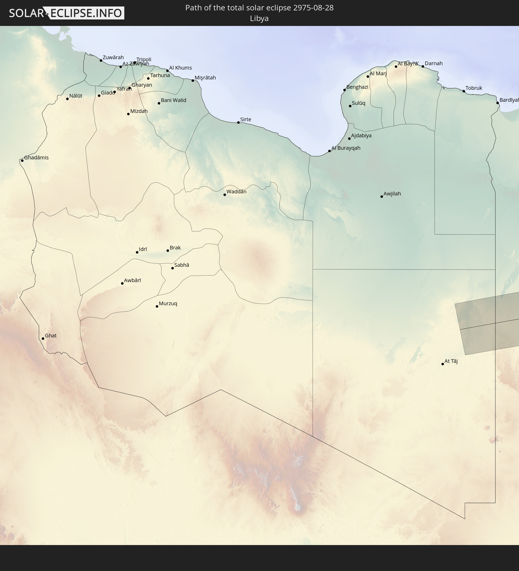 Libya
Libya
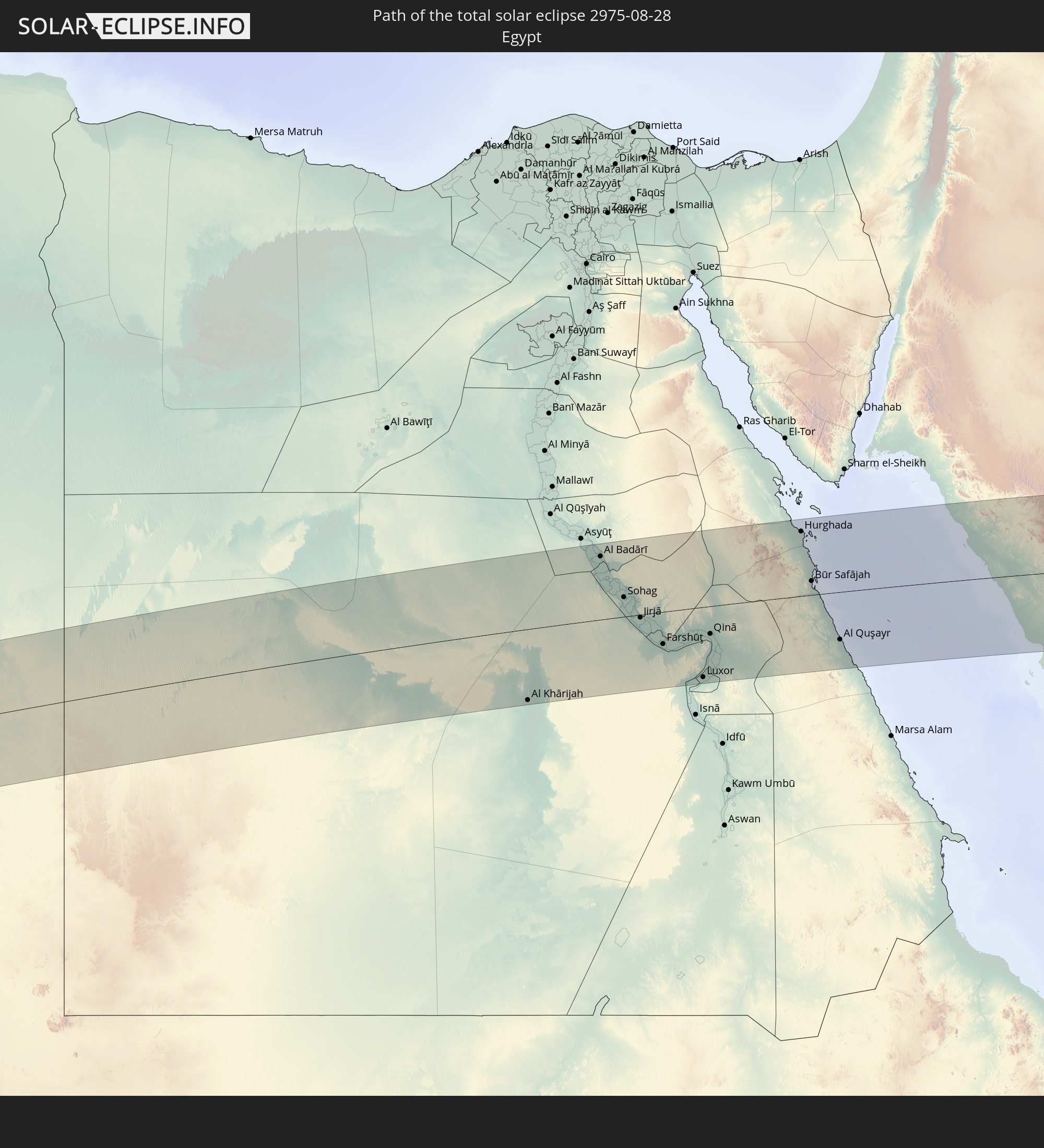 Egypt
Egypt
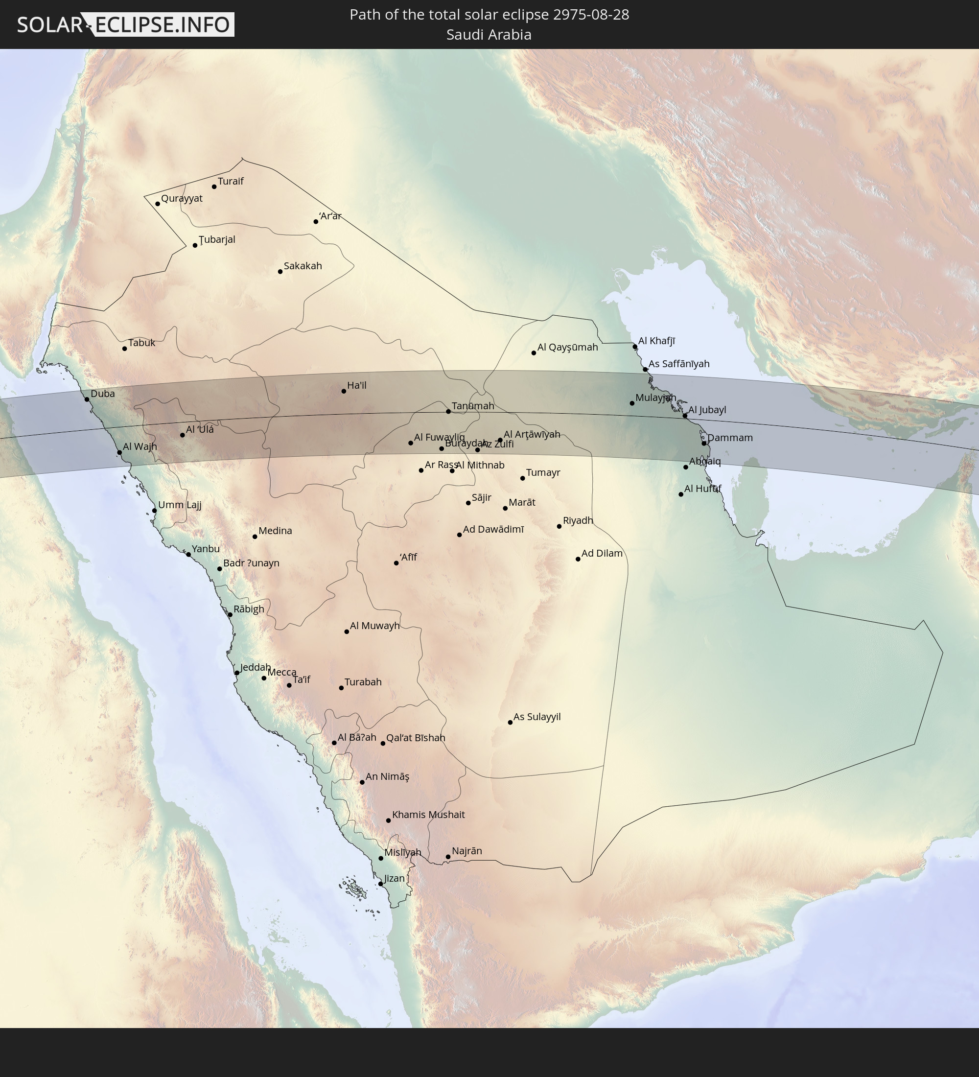 Saudi Arabia
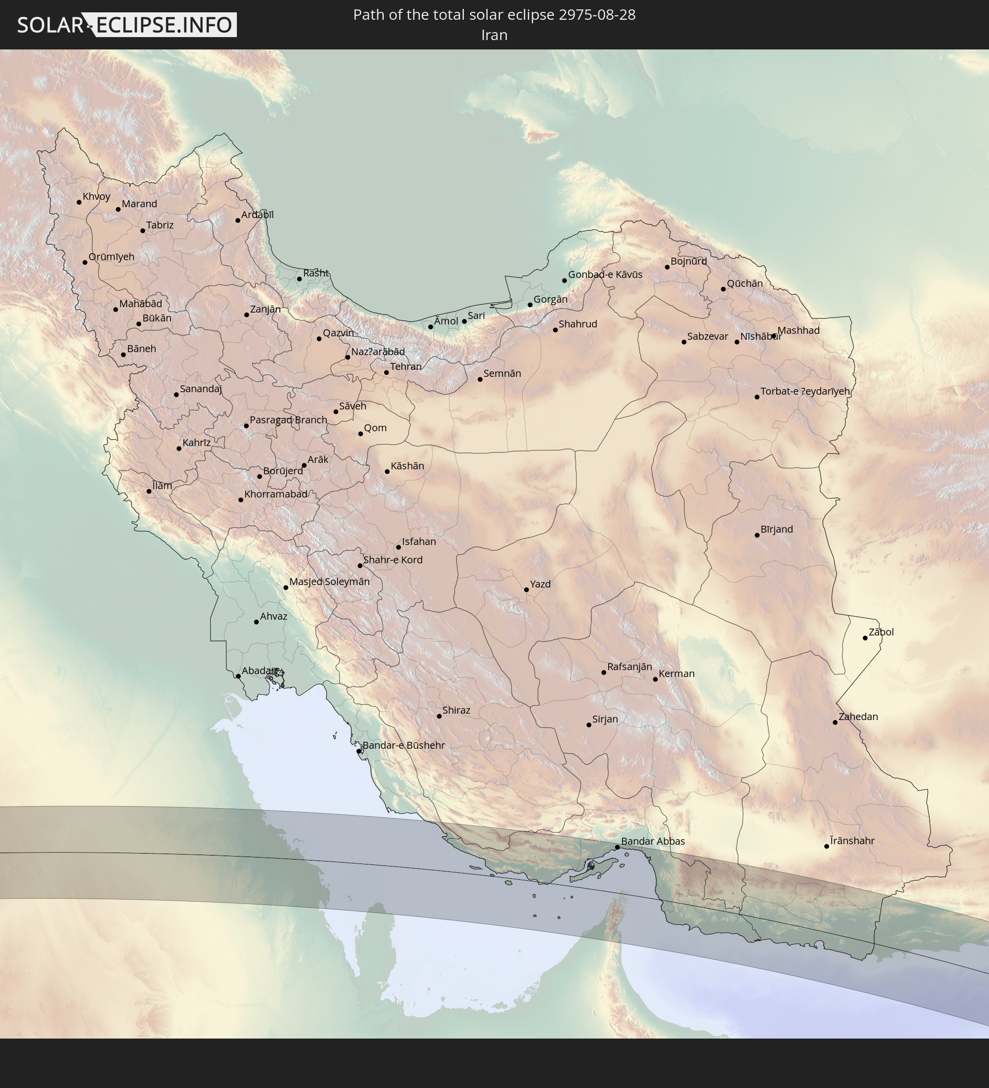 Iran
Iran
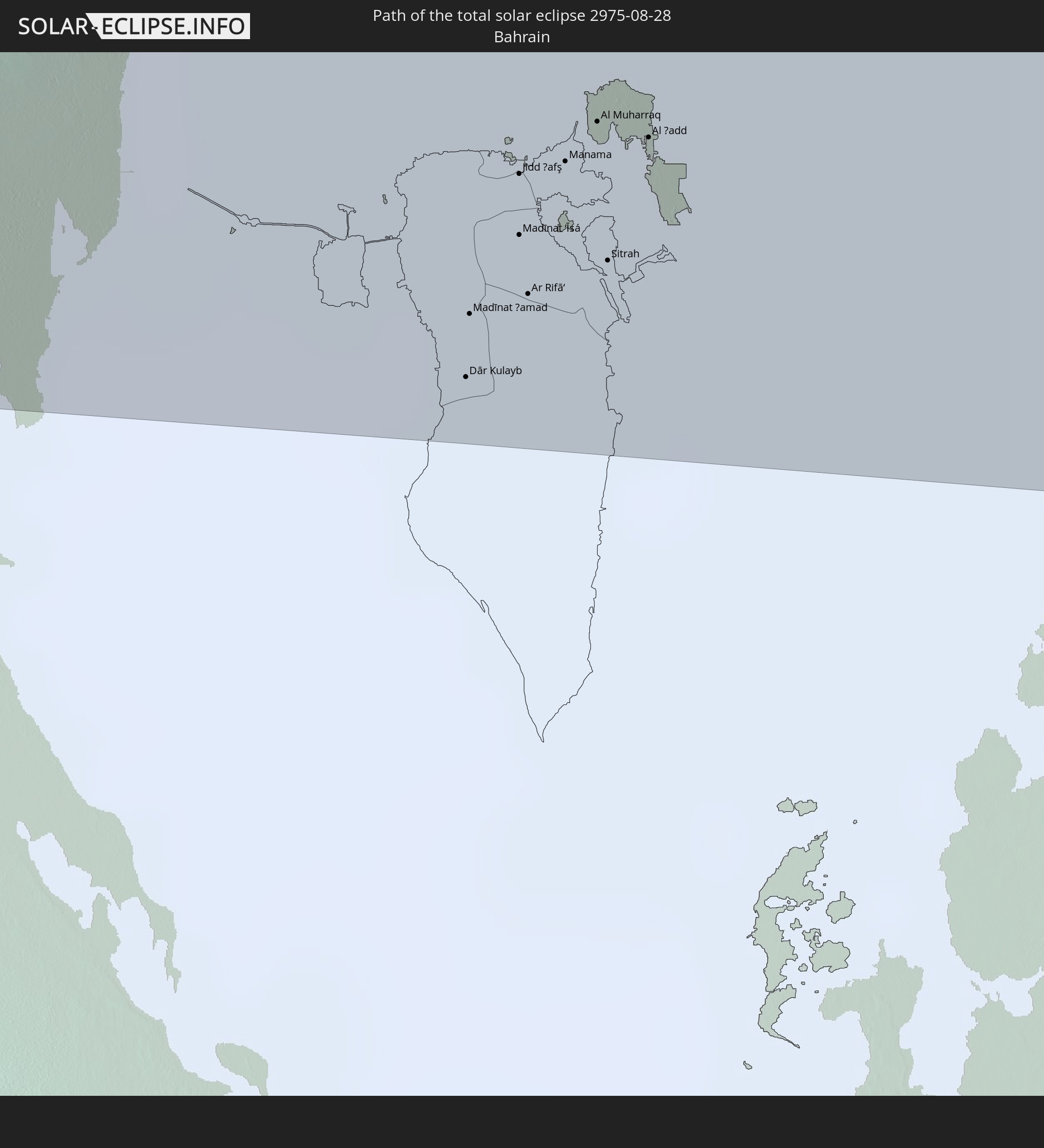 Bahrain
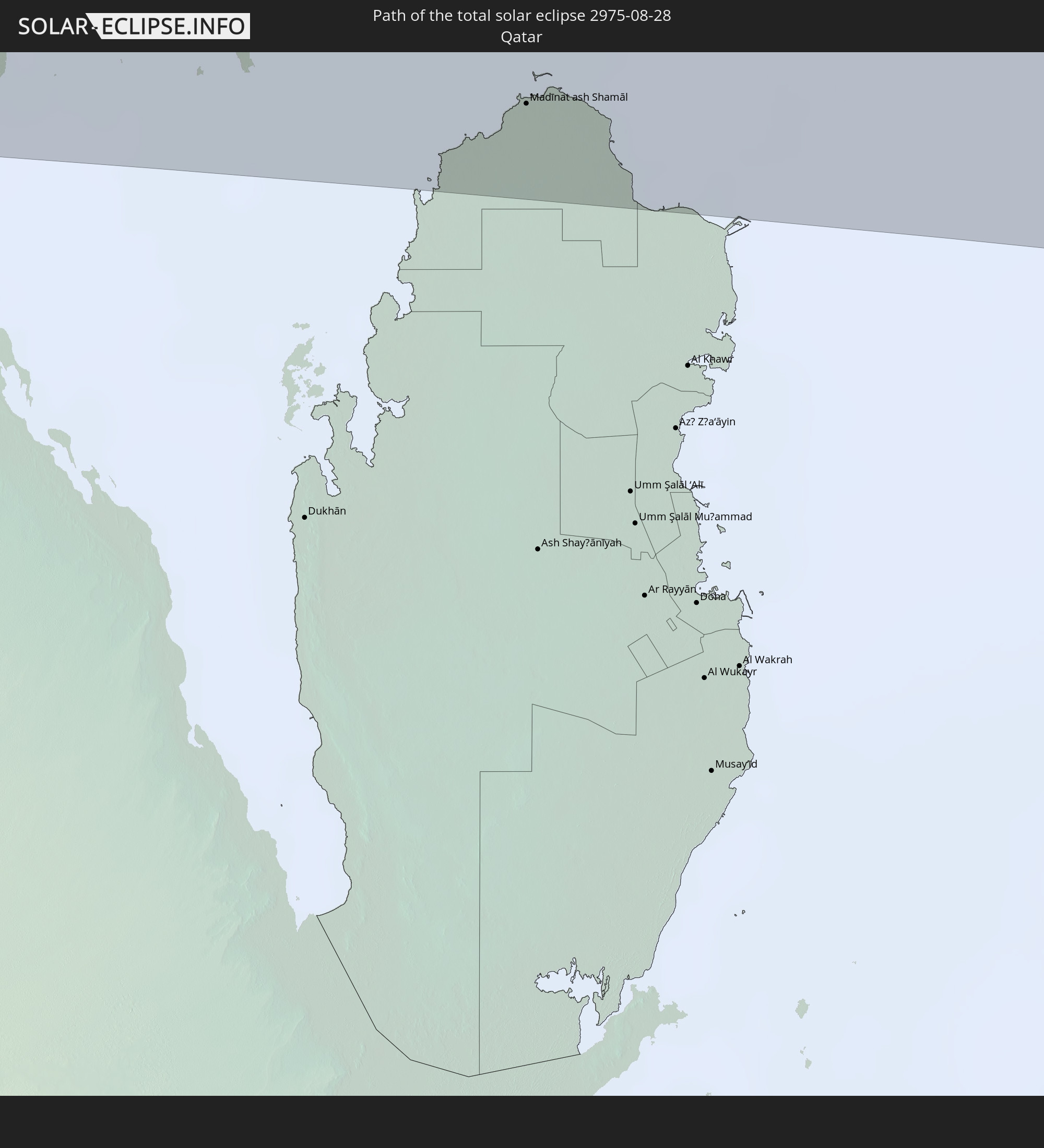 Qatar
Qatar
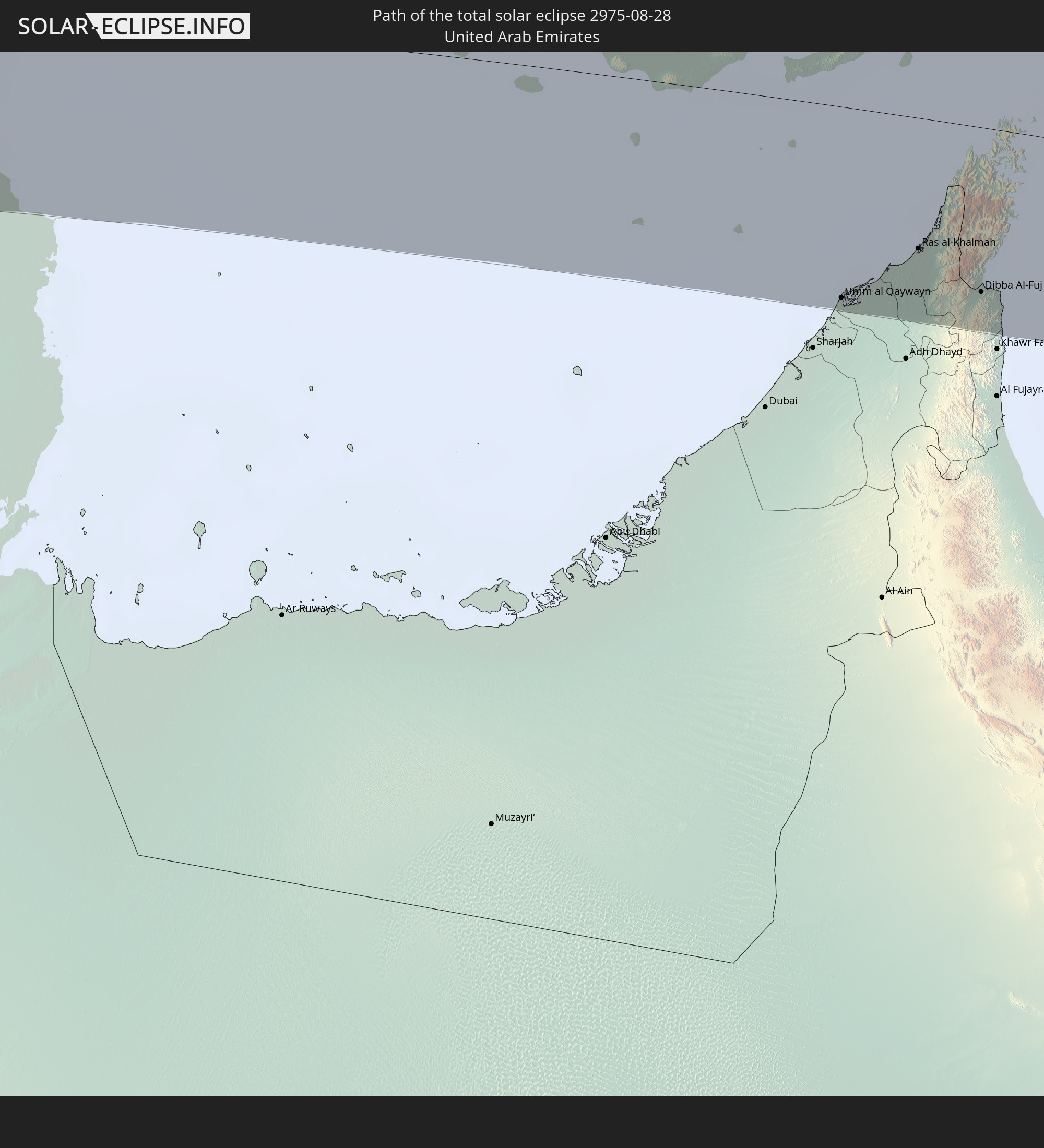 United Arab Emirates
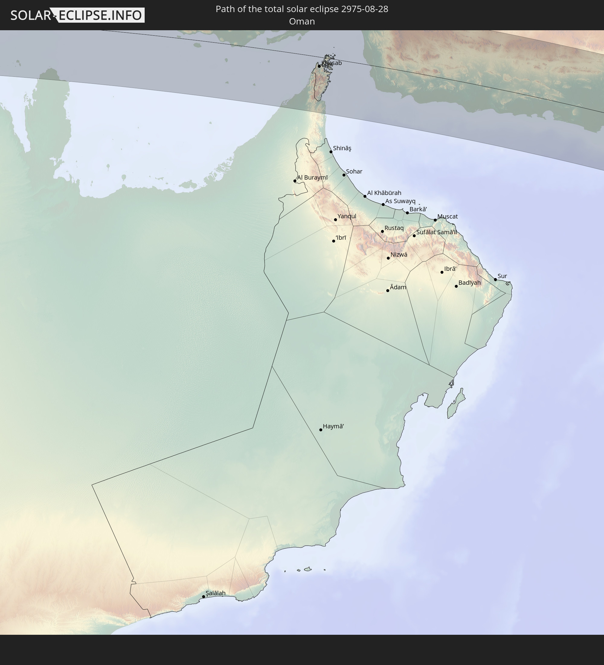 Oman
Oman
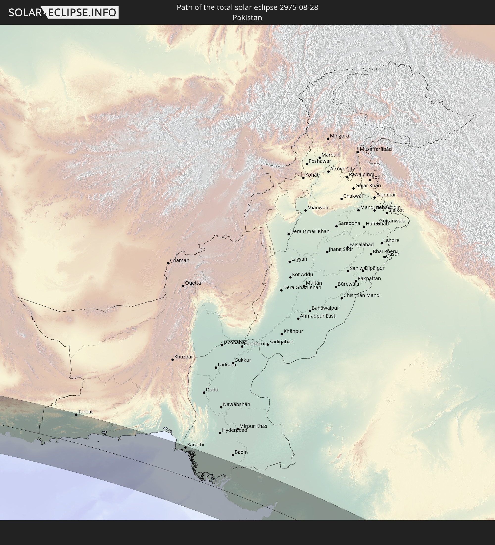 Pakistan
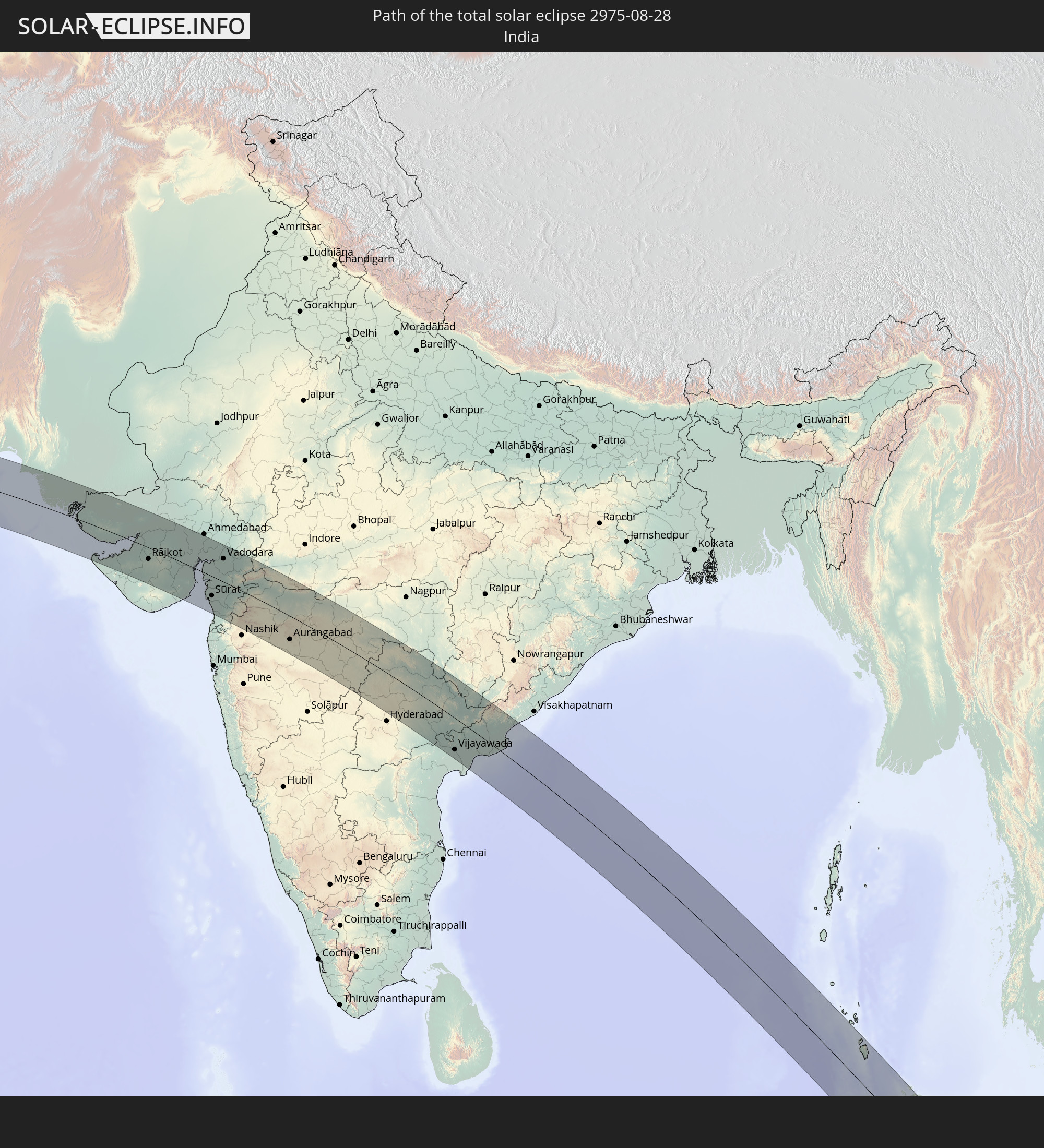 India
India
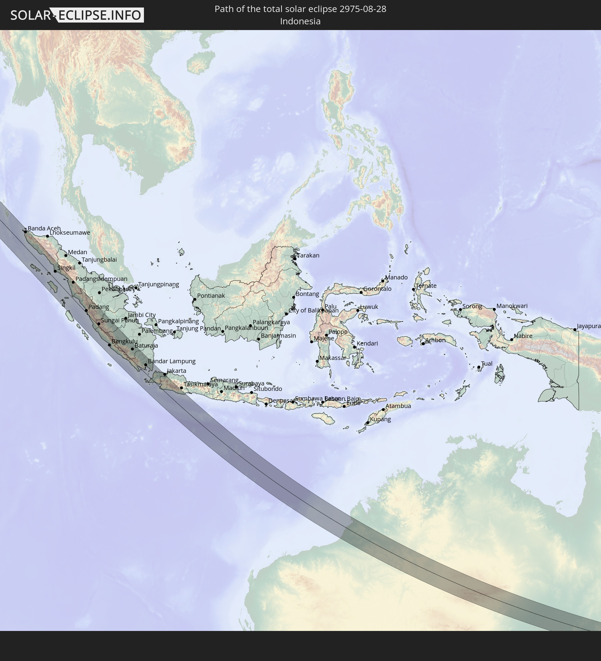 Indonesia
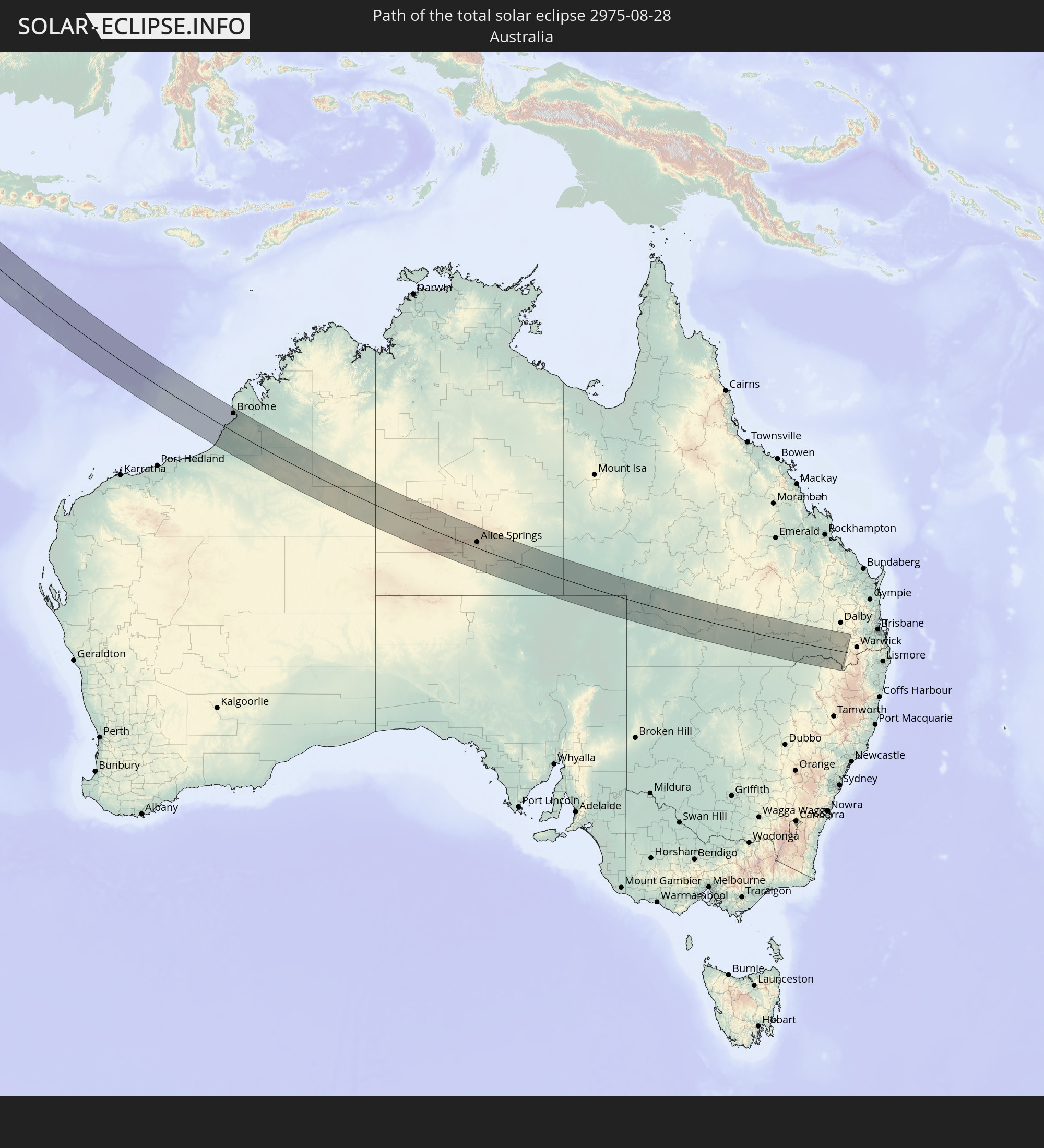 Australia
In den folgenden Ländern ist die Sonnenfinsternis partiell zu sehen
 Russia
 Germany
 Denmark
 Libya
Libya
 Austria
 Sweden
 Czechia
 Democratic Republic of the Congo
 Slovenia
 Croatia
 Poland
 Central African Republic
 Bosnia and Herzegovina
 Hungary
 Slovakia
 Montenegro
 Serbia
 Albania
 Greece
 Romania
 Republic of Macedonia
 Lithuania
 Latvia
 Estonia
 Sudan
Sudan
 Ukraine
 Bulgaria
 Belarus
 Egypt
Egypt
 Turkey
 Moldova
 Rwanda
 Burundi
 Tanzania
 Uganda
 Cyprus
 Ethiopia
 Kenya
Kenya
 State of Palestine
 Israel
 Saudi Arabia
 Jordan
 Lebanon
 Syria
Syria
 Eritrea
 Iraq
Iraq
 Georgia
 Somalia
 Djibouti
 Yemen
Yemen
 Armenia
 Iran
Iran
 Azerbaijan
 Seychelles
 Kazakhstan
 Kuwait
 Bahrain
 Qatar
Qatar
 United Arab Emirates
 Oman
Oman
 Turkmenistan
 Uzbekistan
 Afghanistan
 Pakistan
 Tajikistan
 India
India
 Kyrgyzstan
 British Indian Ocean Territory
 Maldives
 China
China
 Sri Lanka
 Nepal
Nepal
 Mongolia
 Bangladesh
 Bhutan
 Myanmar
 Indonesia
 Cocos Islands
 Thailand
 Malaysia
 Laos
Laos
 Vietnam
 Cambodia
 Singapore
 Christmas Island
 Australia
 Macau
Macau
 Hong Kong
 Brunei
 Taiwan
 Philippines
 East Timor
 Palau
Palau
 Federated States of Micronesia
 Papua New Guinea
 Solomon Islands
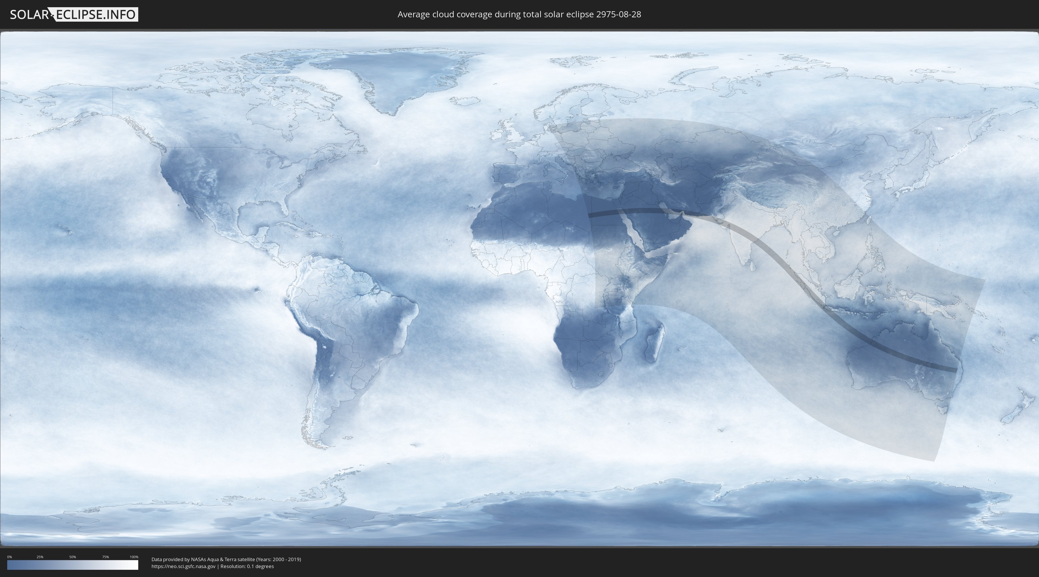
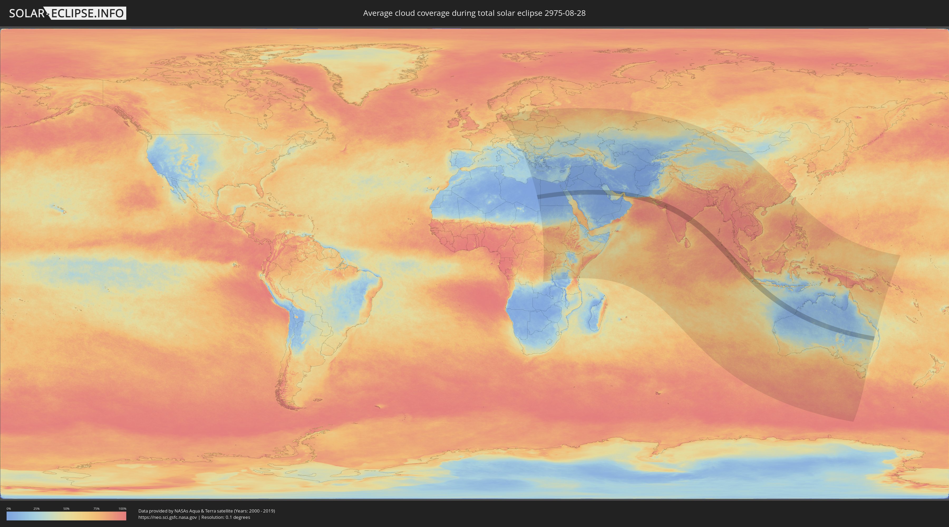
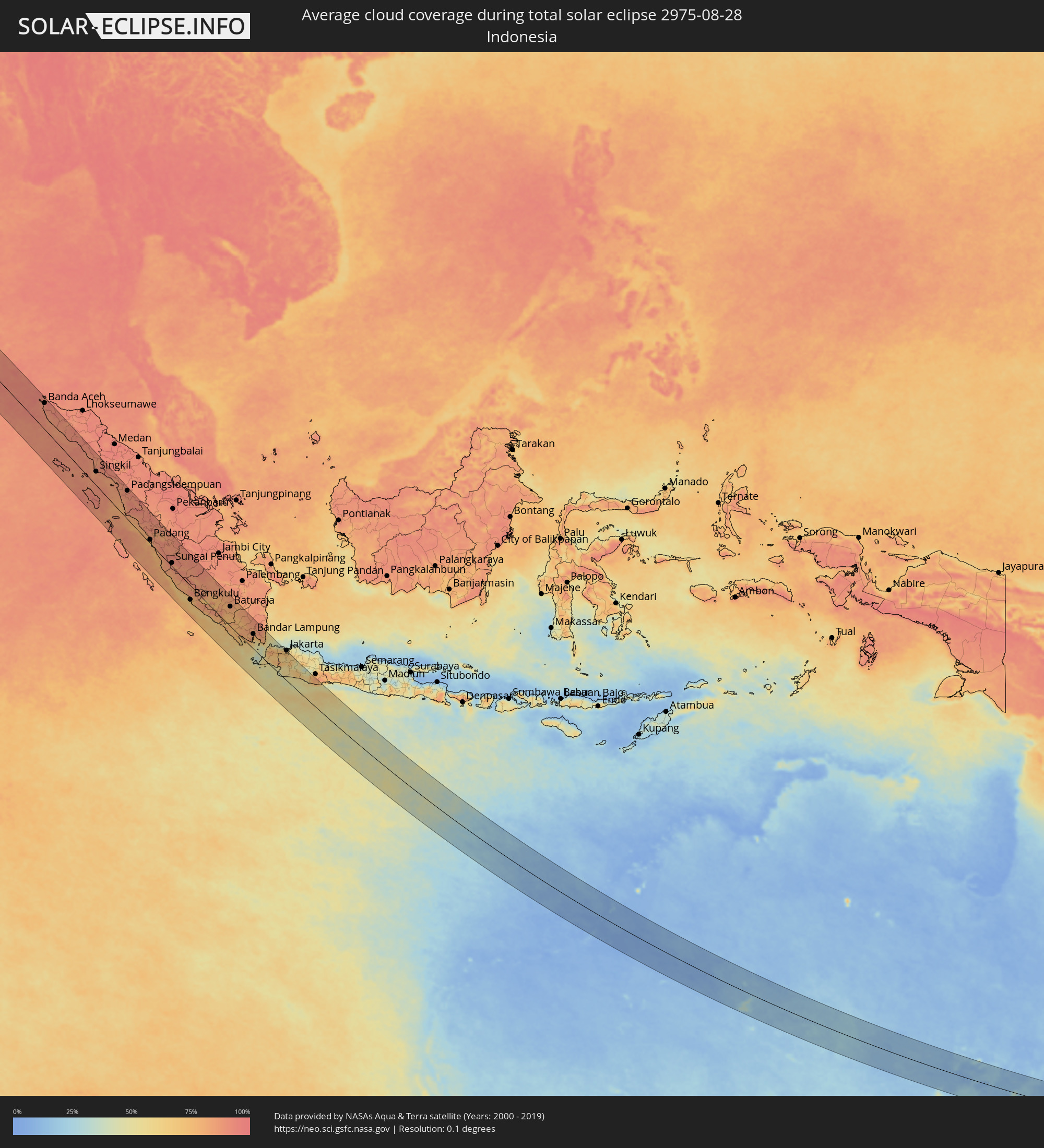
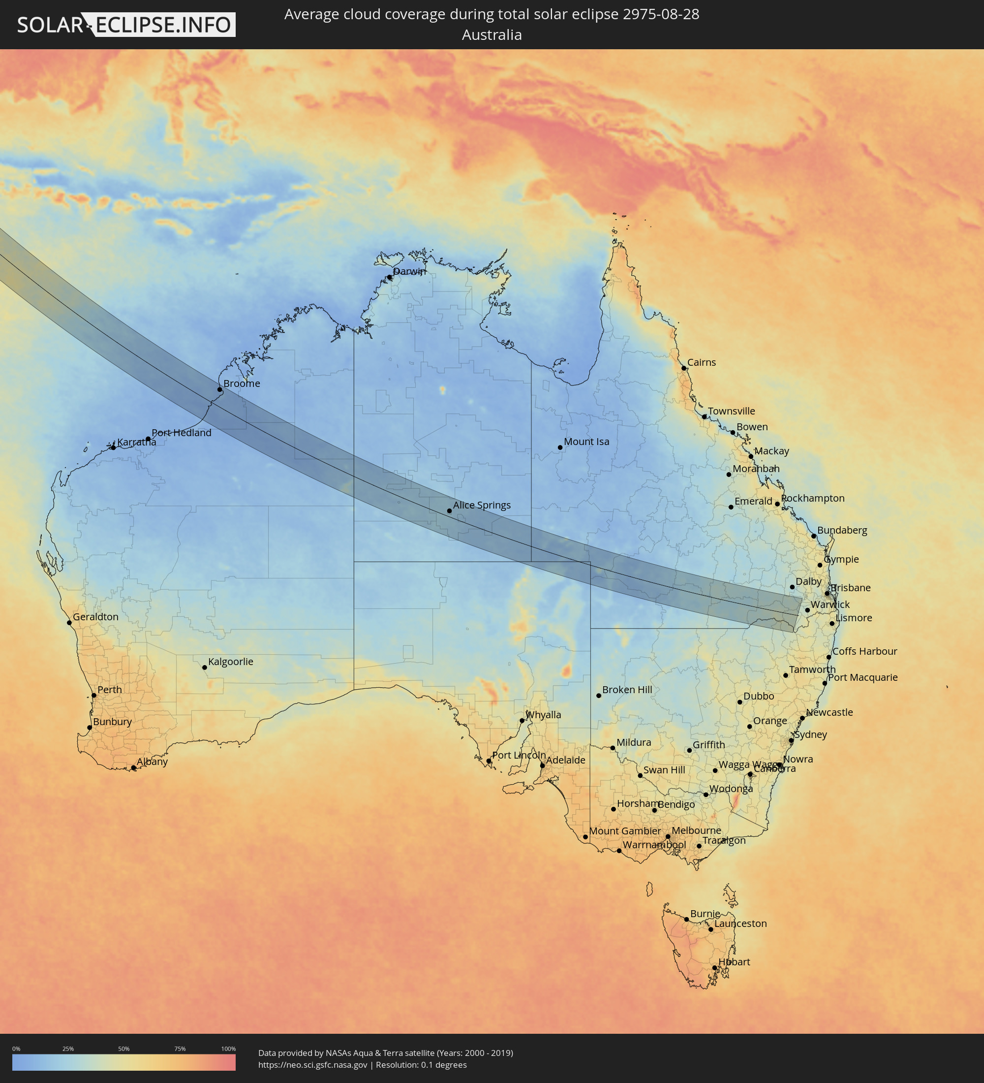
How will be the weather during the total solar eclipse on 08/28/2975?
Where is the best place to see the total solar eclipse of 08/28/2975?
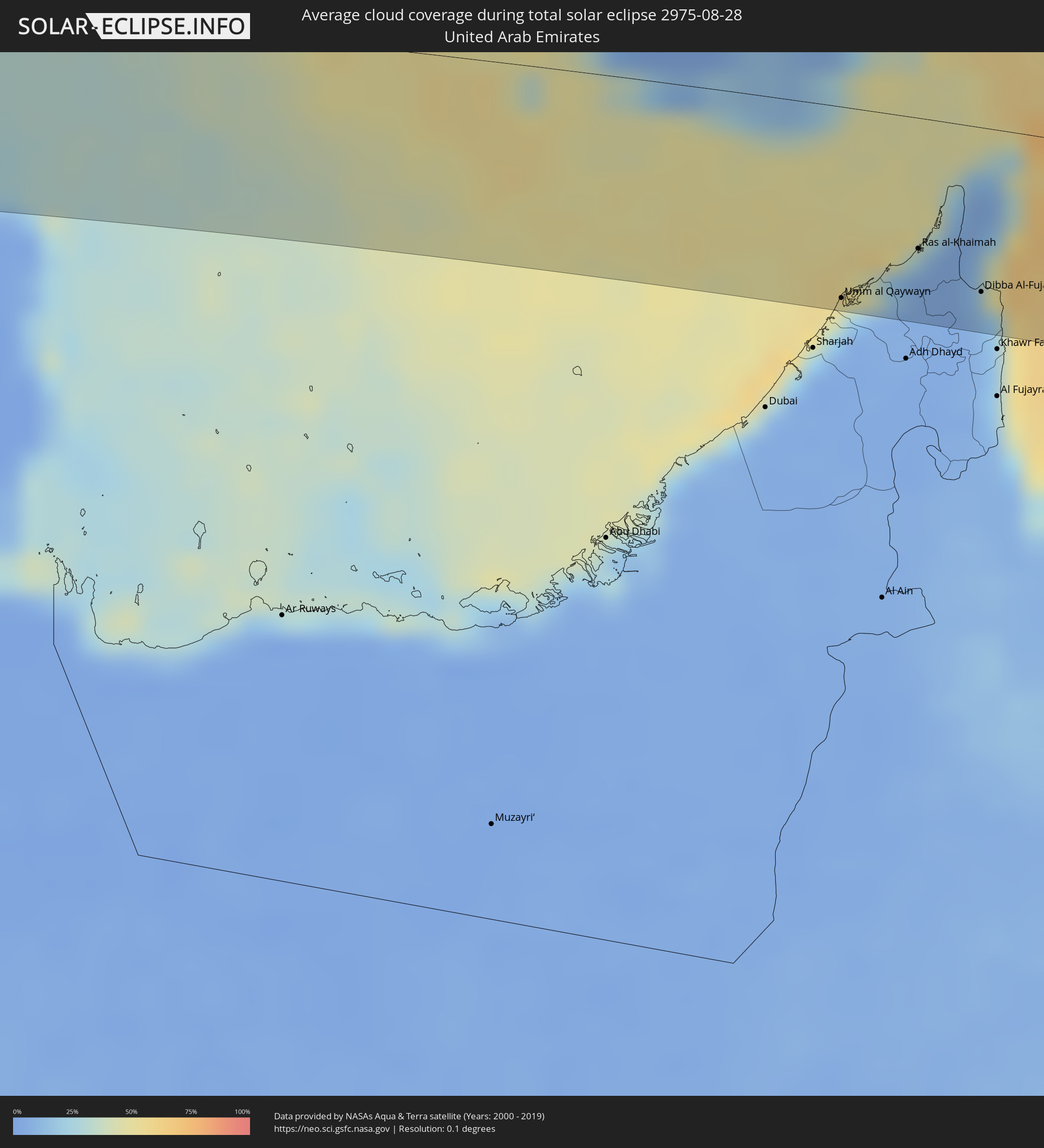
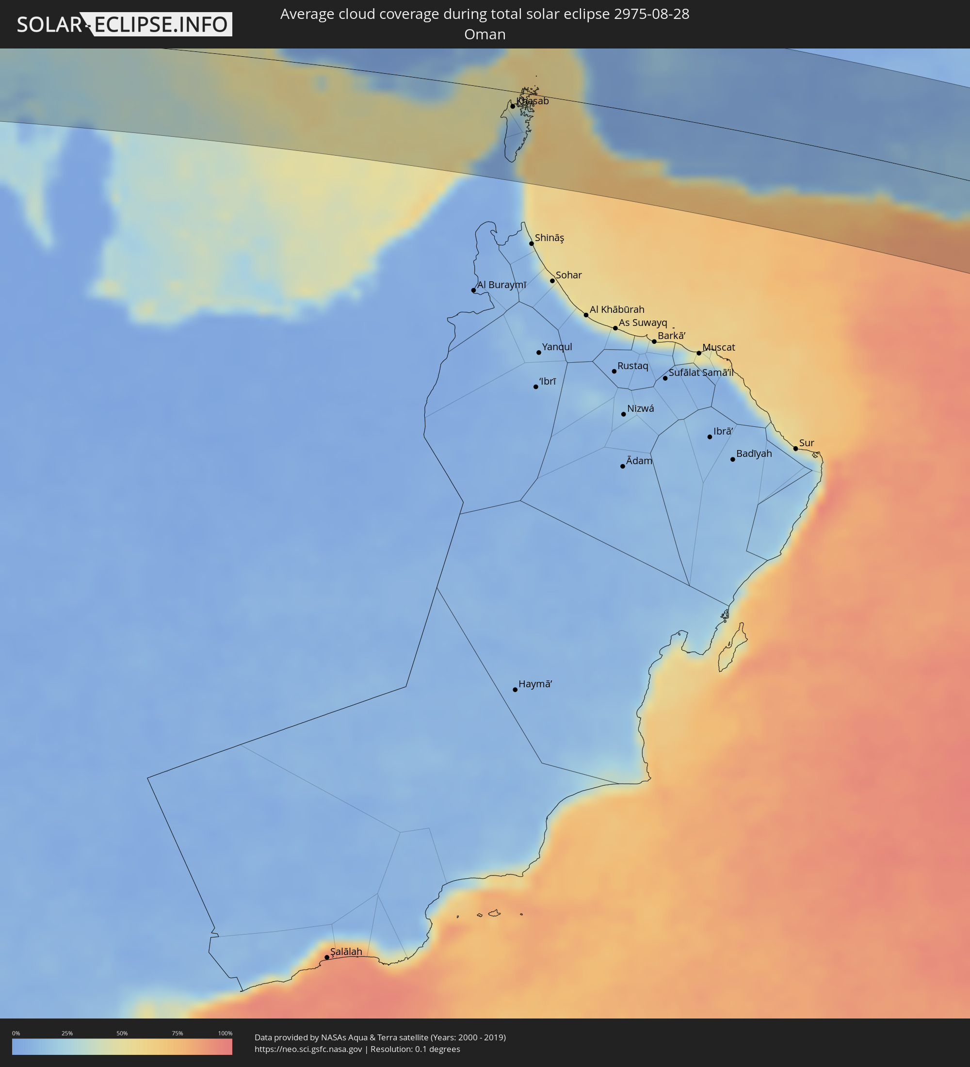
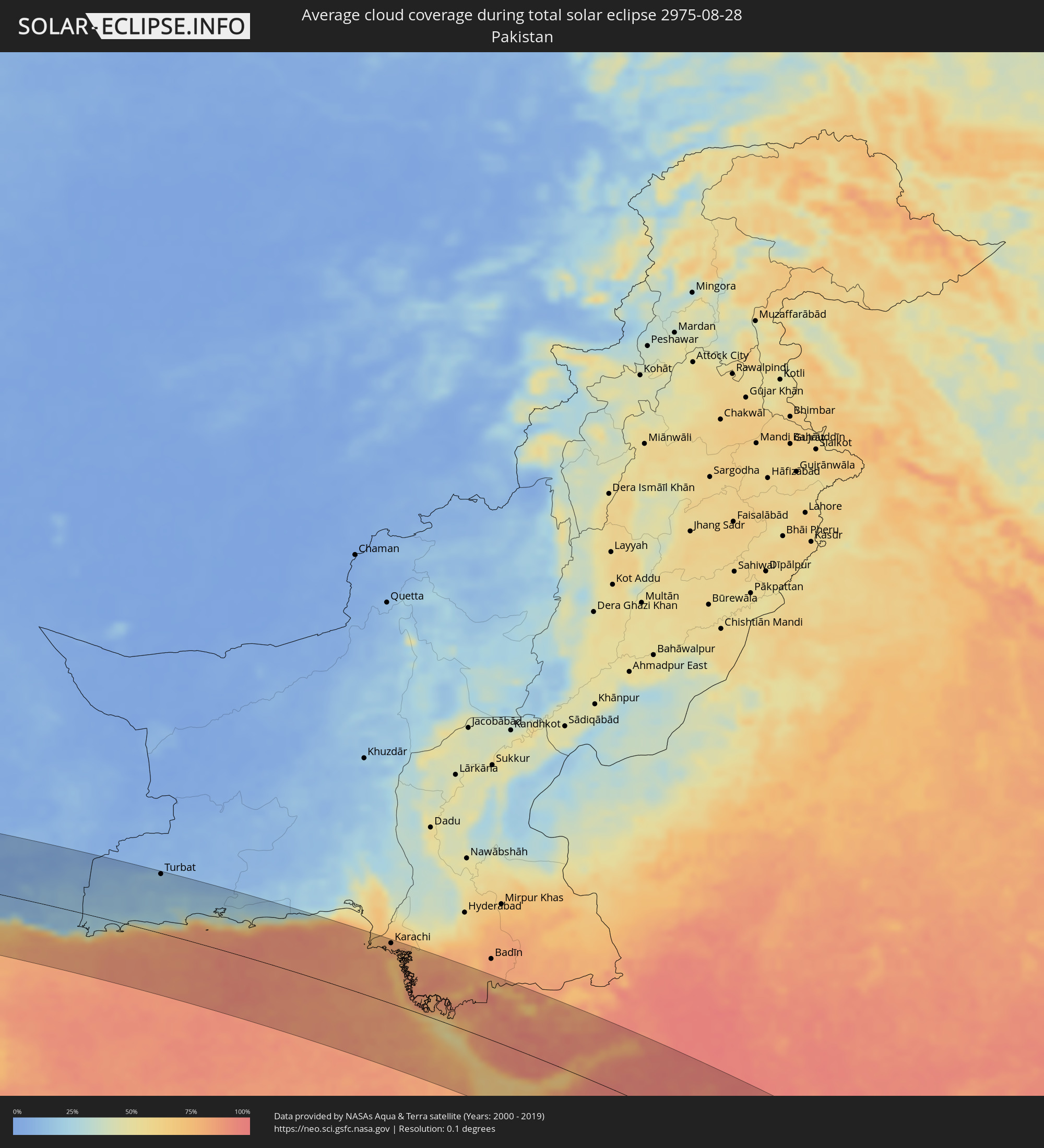
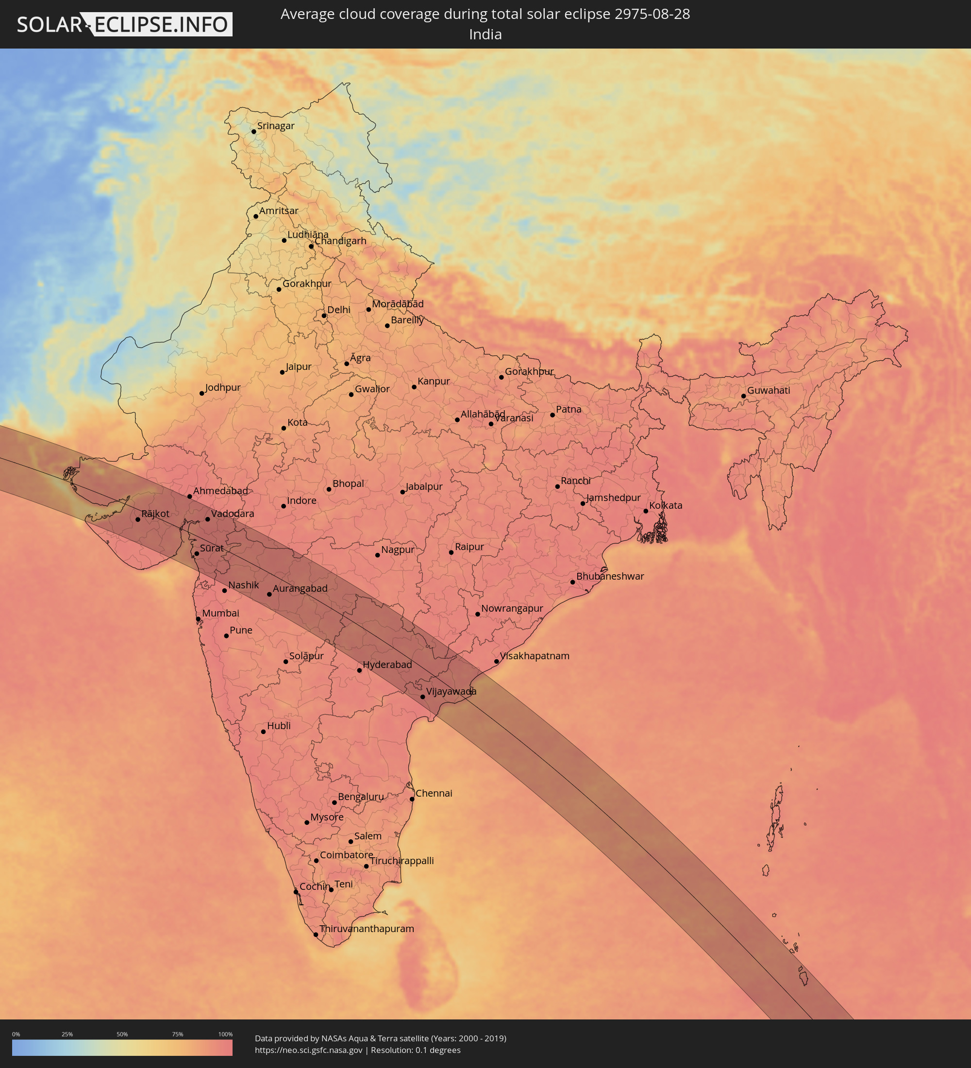
The following maps show the average cloud coverage for the day of the total solar eclipse.
With the help of these maps, it is possible to find the place along the eclipse path, which has the best
chance of a cloudless sky.
Nevertheless, you should consider local circumstances and inform about the weather of your chosen
observation site.
The data is provided by NASAs satellites
AQUA and TERRA.
The cloud maps are averaged over a period of 19 years (2000 - 2019).
Detailed country maps
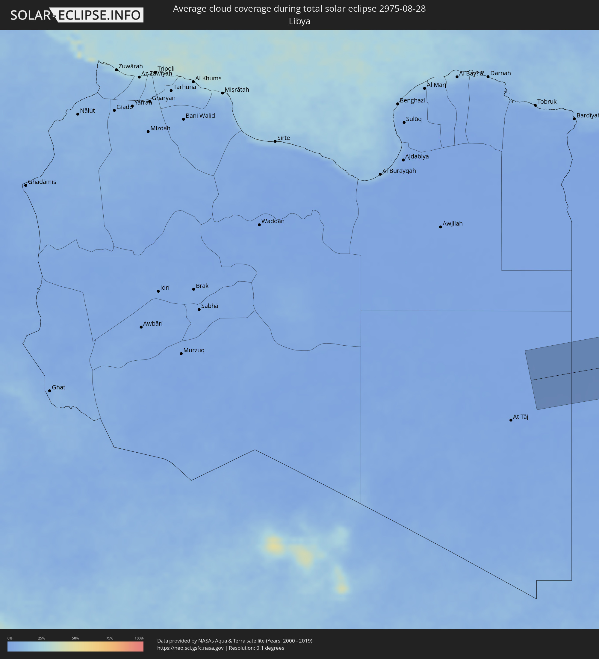 Libya
Libya
 Egypt
Egypt
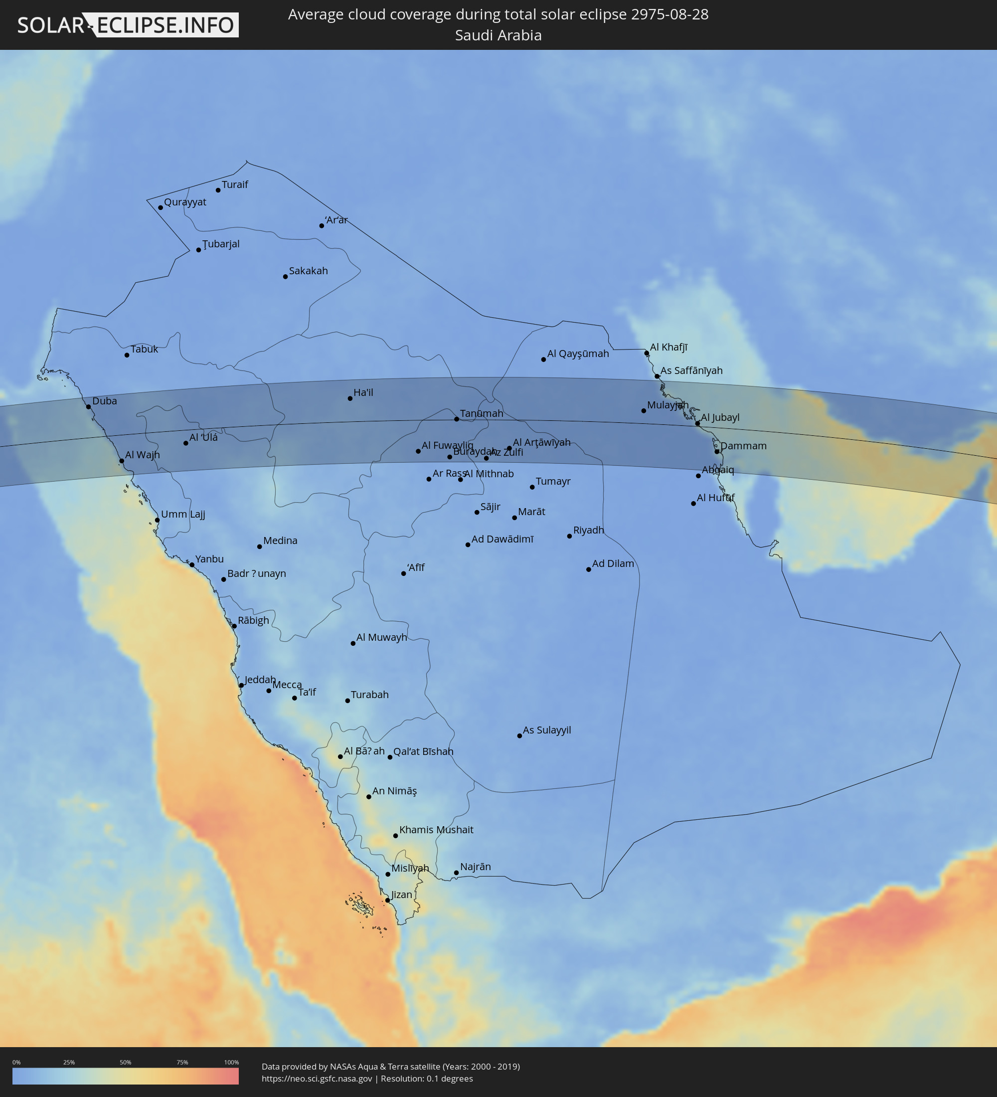 Saudi Arabia
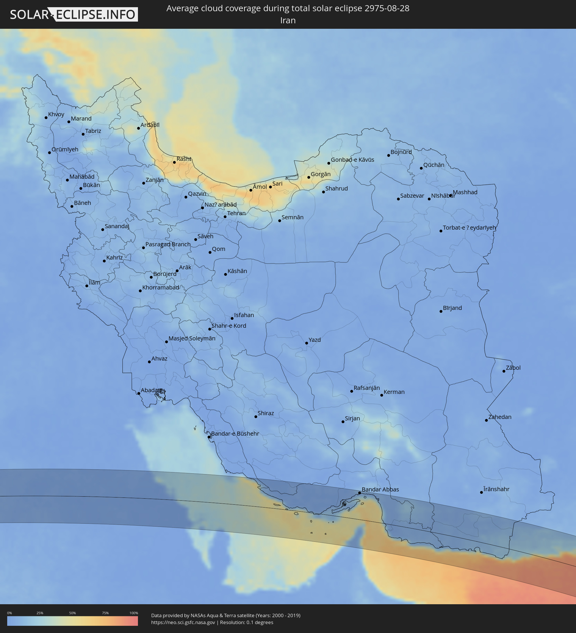 Iran
Iran
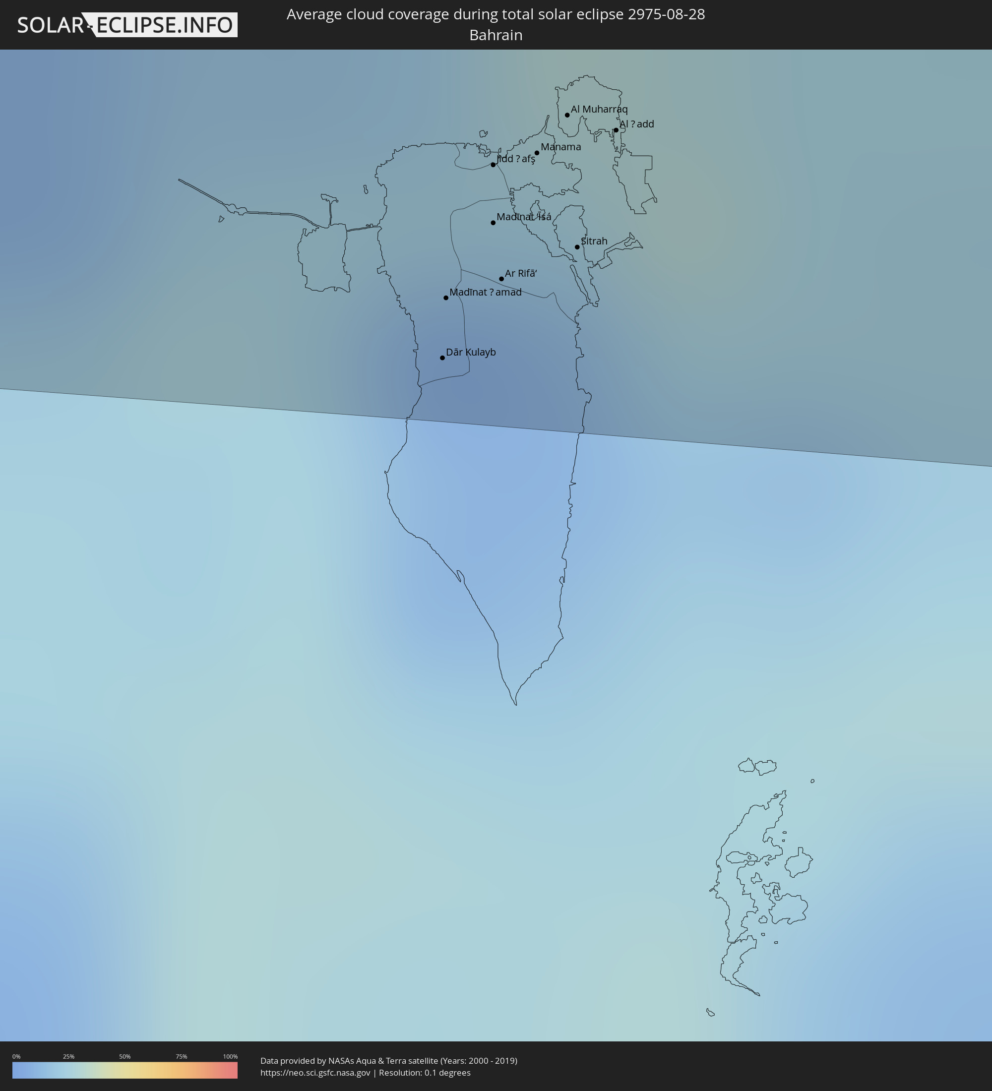 Bahrain
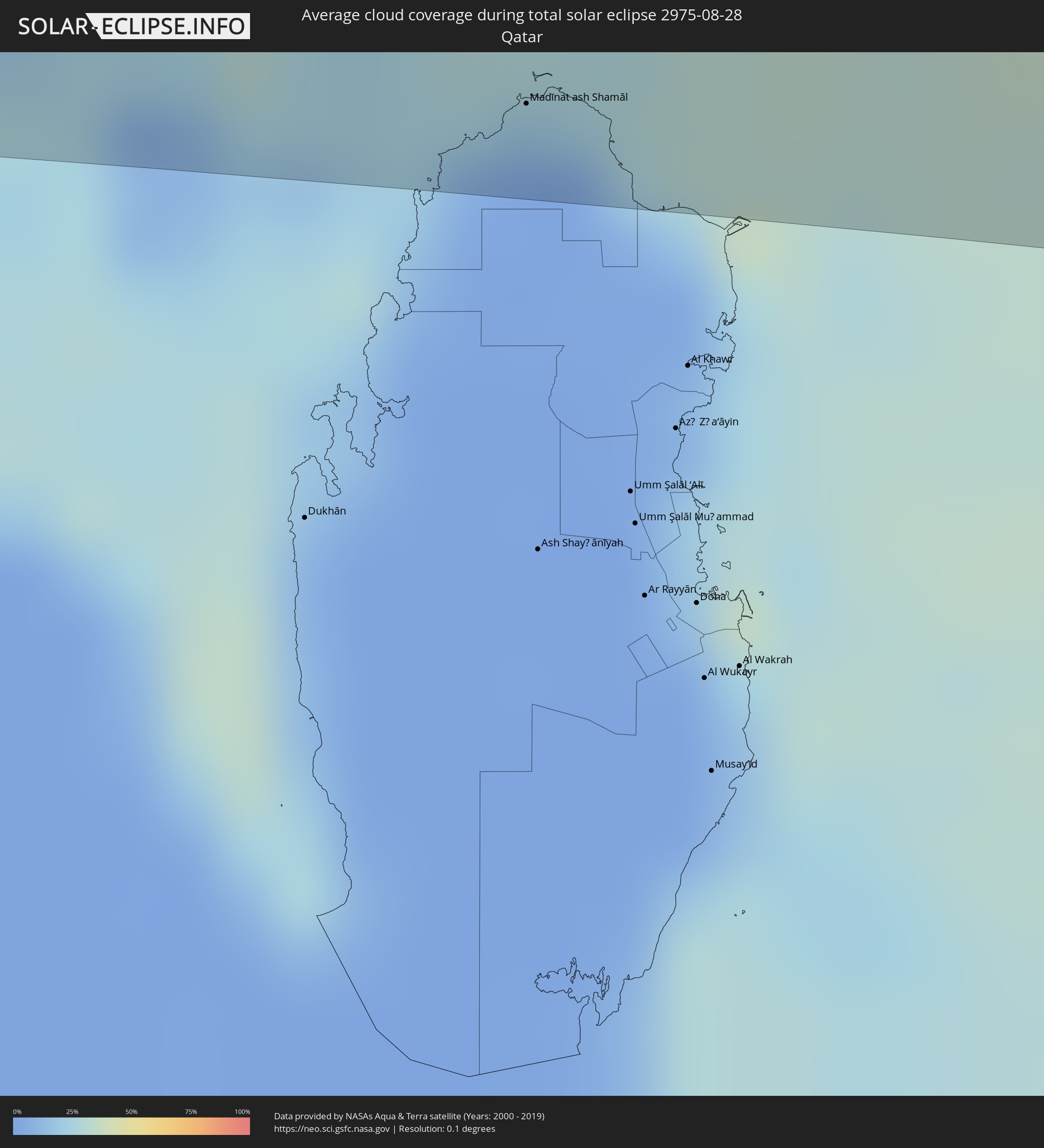 Qatar
Qatar
 United Arab Emirates
 Oman
Oman
 Pakistan
 India
India
 Indonesia
 Australia
Cities inside the path of the eclipse
The following table shows all locations with a population of more than 5,000 inside the eclipse path. Cities which have more than 100,000 inhabitants are marked bold. A click at the locations opens a detailed map.
| City | Type | Eclipse duration | Local time of max. eclipse | Distance to central line | Ø Cloud coverage |
|
Al Khārijah, New Valley
|
total | - | 06:10:08 UTC+02:00 | 84 km | 0% |
|
Abū Tīj, Asyut
|
total | - | 06:10:24 UTC+02:00 | 82 km | 0% |
|
Al Badārī, Asyut
|
total | - | 06:10:25 UTC+02:00 | 75 km | 1% |
|
Juhaynah, Sohag
|
total | - | 06:10:24 UTC+02:00 | 38 km | 0% |
|
Ţahţā, Sohag
|
total | - | 06:10:25 UTC+02:00 | 49 km | 1% |
|
Sohag, Sohag
|
total | - | 06:10:26 UTC+02:00 | 23 km | 1% |
|
Akhmīm, Sohag
|
total | - | 06:10:27 UTC+02:00 | 23 km | 1% |
|
Al Manshāh, Sohag
|
total | - | 06:10:27 UTC+02:00 | 13 km | 1% |
|
Jirjā, Sohag
|
total | - | 06:10:28 UTC+02:00 | 4 km | 1% |
|
Al Balyanā, Sohag
|
total | - | 06:10:29 UTC+02:00 | 16 km | 1% |
|
Farshūţ, Qena
|
total | - | 06:10:30 UTC+02:00 | 38 km | 1% |
|
Naj‘ Ḩammādī, Qena
|
total | - | 06:10:31 UTC+02:00 | 40 km | 0% |
|
Dishnā, Qena
|
total | - | 06:10:35 UTC+02:00 | 34 km | 0% |
|
Luxor, Luxor
|
total | - | 06:10:36 UTC+02:00 | 83 km | 0% |
|
Qinā, Qena
|
total | - | 06:10:38 UTC+02:00 | 33 km | 1% |
|
Kousa, Qena
|
total | - | 06:10:38 UTC+02:00 | 61 km | 0% |
|
Hurghada, Red Sea
|
total | - | 06:11:00 UTC+02:00 | 76 km | 9% |
|
Būr Safājah, Red Sea
|
total | - | 06:11:00 UTC+02:00 | 16 km | 6% |
|
Al Quşayr, Red Sea
|
total | - | 06:11:03 UTC+02:00 | 56 km | 11% |
|
Duba, Tabuk
|
total | - | 07:11:34 UTC+03:00 | 68 km | 12% |
|
Al Wajh, Tabuk
|
total | - | 07:11:47 UTC+03:00 | 61 km | 20% |
|
Al ‘Ulá, Al Madīnah al Munawwarah
|
total | - | 07:12:22 UTC+03:00 | 32 km | 5% |
|
Ha'il, Ḩāʼil
|
total | - | 07:14:10 UTC+03:00 | 51 km | 8% |
|
Buraydah, Al-Qassim
|
total | - | 07:15:31 UTC+03:00 | 86 km | 4% |
|
Tanūmah, Al-Qassim
|
total | - | 07:15:35 UTC+03:00 | 0 km | 2% |
|
Az Zulfi, Ar Riyāḑ
|
total | - | 07:16:04 UTC+03:00 | 89 km | 5% |
|
Al Arţāwīyah, Ar Riyāḑ
|
total | - | 07:16:24 UTC+03:00 | 66 km | 3% |
|
Al Jubayl, Eastern Province
|
total | - | 07:19:36 UTC+03:00 | 5 km | 13% |
|
Umm as Sāhik, Eastern Province
|
total | - | 07:19:52 UTC+03:00 | 33 km | 1% |
|
Al Awjām, Eastern Province
|
total | - | 07:19:55 UTC+03:00 | 43 km | 1% |
|
Şafwá, Eastern Province
|
total | - | 07:19:54 UTC+03:00 | 33 km | 6% |
|
Al Qaţīf, Eastern Province
|
total | - | 07:19:59 UTC+03:00 | 47 km | 2% |
|
Tārūt, Eastern Province
|
total | - | 07:19:59 UTC+03:00 | 41 km | 6% |
|
Sayhāt, Eastern Province
|
total | - | 07:20:00 UTC+03:00 | 51 km | 2% |
|
Raḩīmah, Eastern Province
|
total | - | 07:19:59 UTC+03:00 | 26 km | 25% |
|
Dammam, Eastern Province
|
total | - | 07:20:04 UTC+03:00 | 56 km | 1% |
|
Dhahran, Eastern Province
|
total | - | 07:20:06 UTC+03:00 | 72 km | 2% |
|
Khobar, Eastern Province
|
total | - | 07:20:11 UTC+03:00 | 73 km | 11% |
|
Dār Kulayb, Southern Governorate
|
total | - | 07:20:29 UTC+03:00 | 94 km | 11% |
|
Madīnat Ḩamad, Central Governorate
|
total | - | 07:20:29 UTC+03:00 | 89 km | 11% |
|
Madīnat ‘Īsá, Southern Governorate
|
total | - | 07:20:30 UTC+03:00 | 82 km | 8% |
|
Jidd Ḩafş, Manama
|
total | - | 07:20:30 UTC+03:00 | 77 km | 8% |
|
Ar Rifā‘, Southern Governorate
|
total | - | 07:20:31 UTC+03:00 | 87 km | 10% |
|
Manama, Manama
|
total | - | 07:20:32 UTC+03:00 | 76 km | 12% |
|
Al Muharraq, Muharraq
|
total | - | 07:20:33 UTC+03:00 | 72 km | 23% |
|
Sitrah, Manama
|
total | - | 07:20:34 UTC+03:00 | 84 km | 12% |
|
Al Ḩadd, Muharraq
|
total | - | 07:20:35 UTC+03:00 | 73 km | 23% |
|
Madīnat ash Shamāl, Madīnat ash Shamāl
|
total | - | 07:21:06 UTC+03:00 | 82 km | 3% |
|
Kīsh, Hormozgan
|
total | - | 07:53:41 UTC+03:30 | 6 km | 37% |
|
Bandar-e Lengeh, Hormozgan
|
total | - | 07:54:33 UTC+03:30 | 5 km | 18% |
|
Umm al Qaywayn, Umm al Qaywayn
|
total | - | 08:25:35 UTC+04:00 | 96 km | 21% |
|
Ras al-Khaimah, Raʼs al Khaymah
|
total | - | 08:25:56 UTC+04:00 | 65 km | 29% |
|
Khasab, Musandam
|
total | - | 08:26:07 UTC+04:00 | 18 km | 17% |
|
Dibba Al-Fujairah, Al Fujayrah
|
total | - | 08:26:21 UTC+04:00 | 82 km | 22% |
|
Qeshm, Hormozgan
|
total | - | 07:55:54 UTC+03:30 | 67 km | 50% |
|
Dibba Al-Hisn, Al Fujayrah
|
total | - | 08:26:21 UTC+04:00 | 79 km | 22% |
|
Bandar Abbas, Hormozgan
|
total | - | 07:55:50 UTC+03:30 | 94 km | 26% |
|
Mīnāb, Hormozgan
|
total | - | 07:56:44 UTC+03:30 | 100 km | 7% |
|
Chabahar, Sistan and Baluchestan
|
total | - | 08:01:42 UTC+03:30 | 33 km | 67% |
|
Qaşr-e Qand, Sistan and Baluchestan
|
total | - | 08:01:22 UTC+03:30 | 73 km | 8% |
|
Jīwani, Balochistān
|
total | - | 09:33:16 UTC+05:00 | 34 km | 80% |
|
Gwadar, Balochistān
|
total | - | 09:33:59 UTC+05:00 | 12 km | 80% |
|
Turbat, Balochistān
|
total | - | 09:34:28 UTC+05:00 | 101 km | 16% |
|
Pasni, Balochistān
|
total | - | 09:35:27 UTC+05:00 | 32 km | 60% |
|
Ormāra, Balochistān
|
total | - | 09:37:06 UTC+05:00 | 59 km | 75% |
|
Karachi, Sindh
|
total | - | 09:40:52 UTC+05:00 | 101 km | 82% |
|
Ghāro, Sindh
|
total | - | 09:41:44 UTC+05:00 | 101 km | 83% |
|
Mīrpur Sakro, Sindh
|
total | - | 09:41:57 UTC+05:00 | 82 km | 86% |
|
Chuhar Jamāli, Sindh
|
total | - | 09:42:38 UTC+05:00 | 78 km | 89% |
|
Jāti, Sindh
|
total | - | 09:43:05 UTC+05:00 | 83 km | 85% |
|
Jāmnagar, Gujarat
|
total | - | 10:17:37 UTC+05:30 | 45 km | 93% |
|
Rājkot, Gujarat
|
total | - | 10:19:00 UTC+05:30 | 34 km | 93% |
|
Bhāvnagar, Gujarat
|
total | - | 10:21:51 UTC+05:30 | 30 km | 92% |
|
Sūrat, Gujarat
|
total | - | 10:23:39 UTC+05:30 | 58 km | 92% |
|
Bilimora, Gujarat
|
total | - | 10:24:22 UTC+05:30 | 95 km | 95% |
|
Vadodara, Gujarat
|
total | - | 10:23:06 UTC+05:30 | 69 km | 96% |
|
Mālegaon, Maharashtra
|
total | - | 10:27:27 UTC+05:30 | 43 km | 92% |
|
Dhūlia, Maharashtra
|
total | - | 10:27:28 UTC+05:30 | 4 km | 92% |
|
Aurangabad, Maharashtra
|
total | - | 10:29:46 UTC+05:30 | 69 km | 95% |
|
Jalgaon, Maharashtra
|
total | - | 10:28:46 UTC+05:30 | 52 km | 95% |
|
Parbhani, Maharashtra
|
total | - | 10:33:13 UTC+05:30 | 54 km | 93% |
|
Akola, Maharashtra
|
total | - | 10:31:44 UTC+05:30 | 97 km | 93% |
|
Nanded, Maharashtra
|
total | - | 10:34:24 UTC+05:30 | 35 km | 93% |
|
Nizāmābād, Telangana
|
total | - | 10:36:34 UTC+05:30 | 38 km | 93% |
|
Rāmgundam, Telangana
|
total | - | 10:38:58 UTC+05:30 | 51 km | 92% |
|
Warangal, Telangana
|
total | - | 10:40:24 UTC+05:30 | 16 km | 93% |
|
Vijayawada, Andhra Pradesh
|
total | - | 10:44:48 UTC+05:30 | 88 km | 96% |
|
Rājahmundry, Andhra Pradesh
|
total | - | 10:46:14 UTC+05:30 | 27 km | 93% |
|
Kākināda, Andhra Pradesh
|
total | - | 10:47:12 UTC+05:30 | 52 km | 91% |
|
Banda Aceh, Aceh
|
total | - | 13:04:47 UTC+07:00 | 95 km | 90% |
|
Padang, West Sumatra
|
total | - | 13:26:49 UTC+07:00 | 14 km | 83% |
|
Payakumbuh, West Sumatra
|
total | - | 13:25:53 UTC+07:00 | 93 km | 88% |
|
Bengkulu, Bengkulu
|
total | - | 13:35:22 UTC+07:00 | 51 km | 74% |
|
Lubuklinggau, South Sumatra
|
total | - | 13:35:25 UTC+07:00 | 35 km | 84% |
|
Baturaja, South Sumatra
|
total | - | 13:39:01 UTC+07:00 | 74 km | 82% |
|
Bandar Lampung, Lampung
|
total | - | 13:43:01 UTC+07:00 | 56 km | 77% |
|
Metro, Lampung
|
total | - | 13:42:32 UTC+07:00 | 85 km | 85% |
|
Serang, Banten
|
total | - | 13:45:32 UTC+07:00 | 70 km | 77% |
|
Rangkasbitung, Banten
|
total | - | 13:46:06 UTC+07:00 | 58 km | 69% |
|
Tangerang, Banten
|
total | - | 13:46:22 UTC+07:00 | 102 km | 72% |
|
South Tangerang, Banten
|
total | - | 13:46:41 UTC+07:00 | 99 km | 72% |
|
Bogor, West Java
|
total | - | 13:47:17 UTC+07:00 | 80 km | 60% |
|
Depok, West Java
|
total | - | 13:47:01 UTC+07:00 | 98 km | 65% |
|
Sukabumi, West Java
|
total | - | 13:48:02 UTC+07:00 | 64 km | 59% |
|
Cileungsir, West Java
|
total | - | 13:47:13 UTC+07:00 | 109 km | 64% |
|
Padalarang, West Java
|
total | - | 13:48:42 UTC+07:00 | 112 km | 54% |
|
Banjaran, West Java
|
total | - | 13:49:12 UTC+07:00 | 104 km | 37% |
|
Paseh, West Java
|
total | - | 13:49:33 UTC+07:00 | 112 km | 49% |
|
Broome, Western Australia
|
total | - | 15:19:54 UTC+08:00 | 80 km | 8% |
|
Alice Springs, Northern Territory
|
total | - | 17:01:14 UTC+09:30 | 26 km | 23% |
|
Goondiwindi, Queensland
|
total | - | 17:36:07 UTC+10:00 | 36 km | 36% |