Total solar eclipse of 05/26/2989
| Day of week: | Tuesday |
| Maximum duration of eclipse: | 05m00s |
| Maximum width of eclipse path: | 179 km |
| Saros cycle: | 163 |
| Coverage: | 100% |
| Magnitude: | 1.0525 |
| Gamma: | -0.2555 |
Wo kann man die Sonnenfinsternis vom 05/26/2989 sehen?
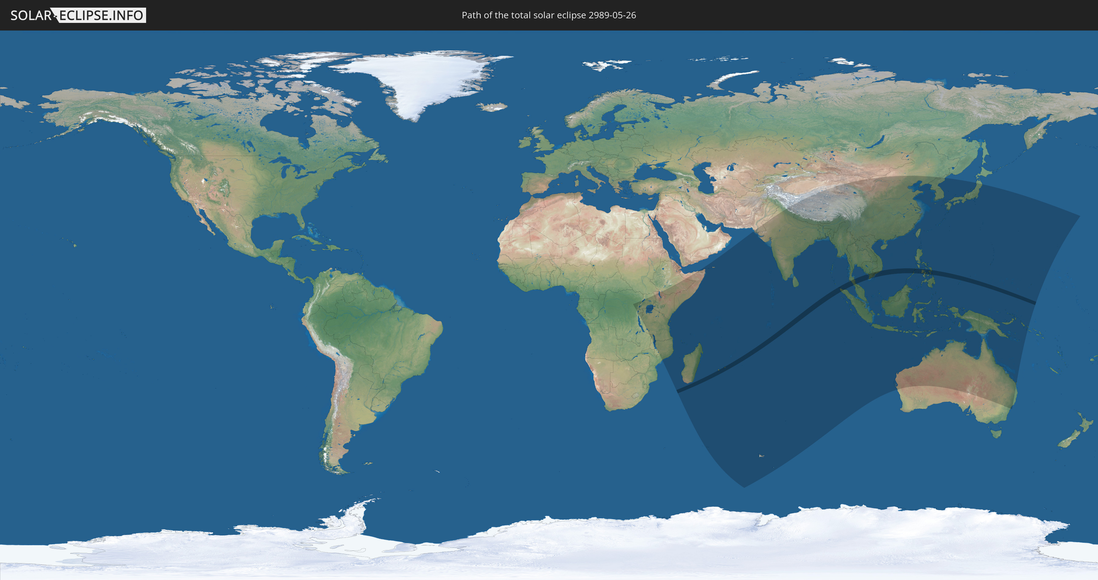
Die Sonnenfinsternis am 05/26/2989 kann man in 57 Ländern als partielle Sonnenfinsternis beobachten.
Der Finsternispfad verläuft durch 6 Länder. Nur in diesen Ländern ist sie als total Sonnenfinsternis zu sehen.
In den folgenden Ländern ist die Sonnenfinsternis total zu sehen
 Réunion
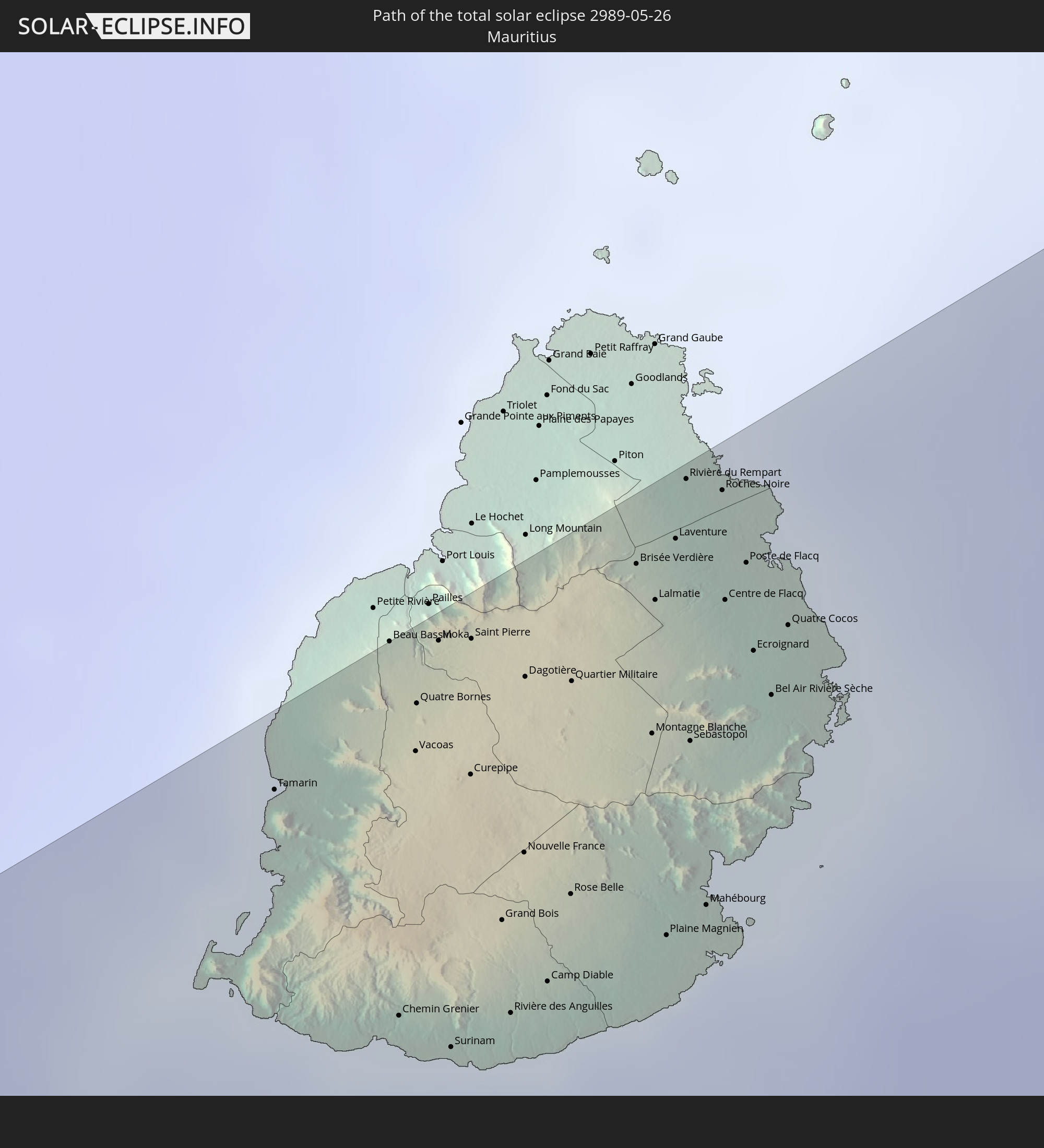 Mauritius
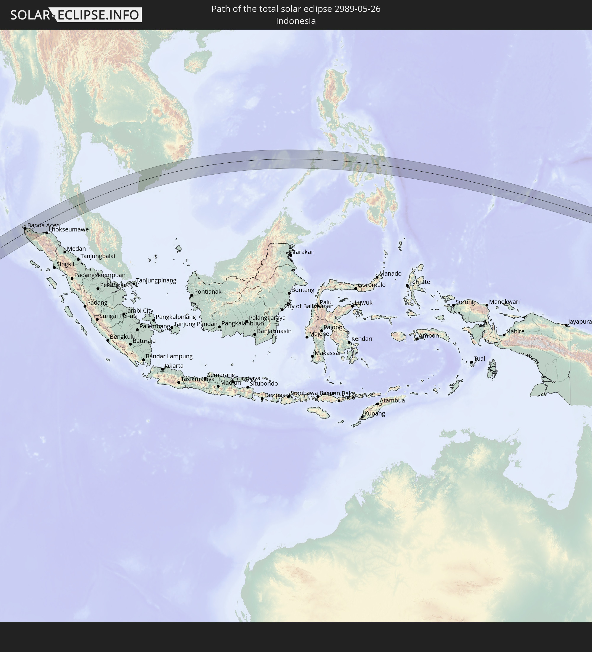 Indonesia
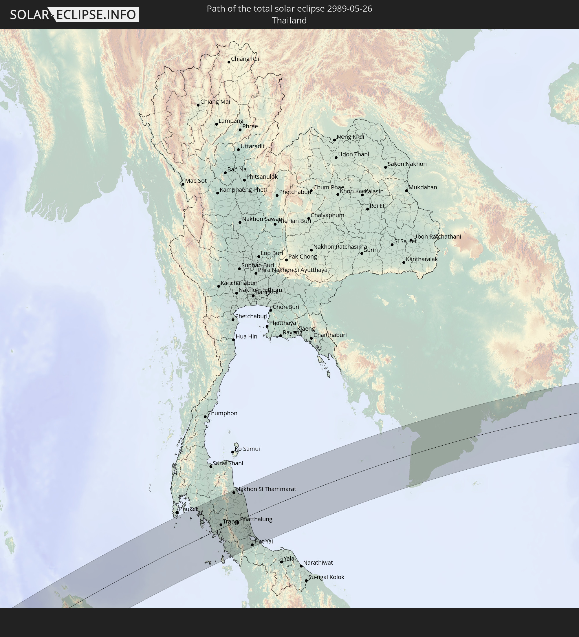 Thailand
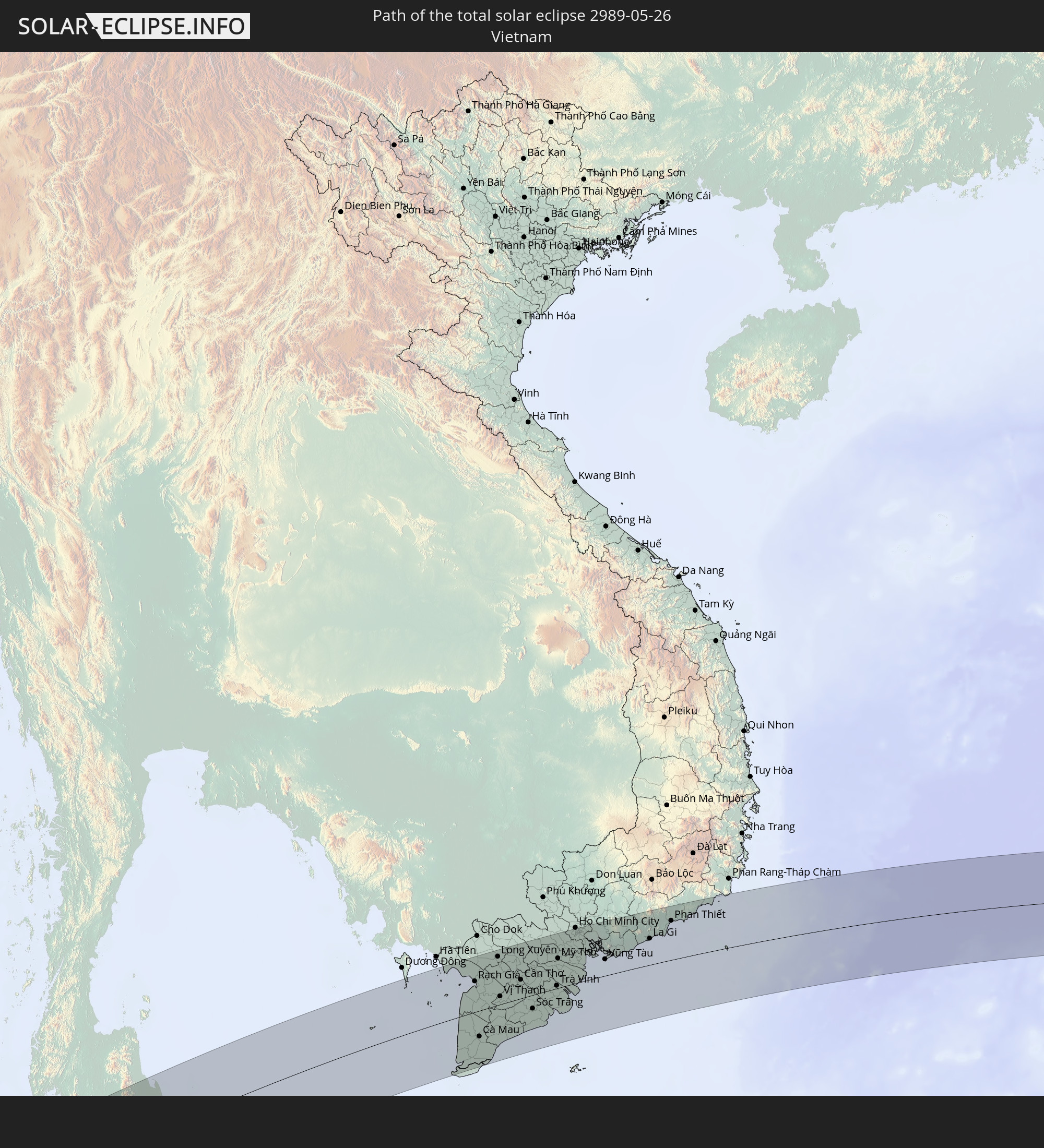 Vietnam
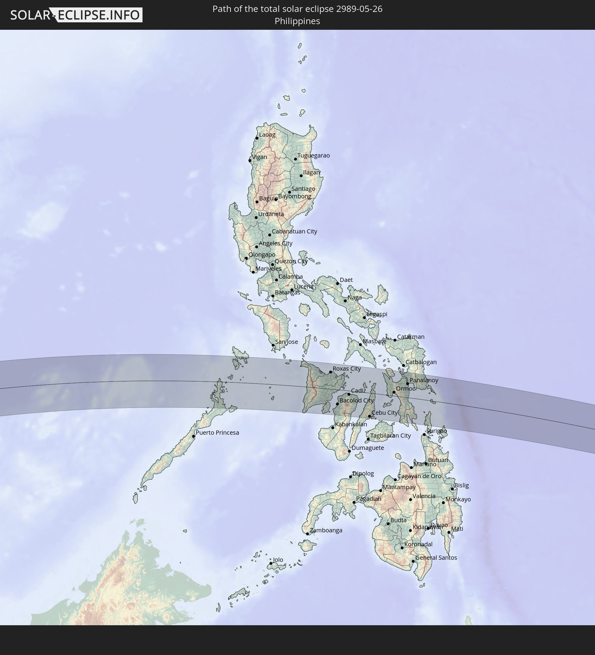 Philippines
In den folgenden Ländern ist die Sonnenfinsternis partiell zu sehen
 United States Minor Outlying Islands
 Democratic Republic of the Congo
 Zambia
 Rwanda
 Burundi
 Tanzania
 Uganda
 Mozambique
 Malawi
 Ethiopia
 Kenya
Kenya
 French Southern and Antarctic Lands
 Somalia
 Yemen
Yemen
 Madagascar
 Comoros
 Mayotte
 Seychelles
 Réunion
 Mauritius
 Pakistan
 India
India
 British Indian Ocean Territory
 Heard Island and McDonald Islands
 Maldives
 China
China
 Sri Lanka
 Nepal
Nepal
 Bangladesh
 Bhutan
 Myanmar
 Indonesia
 Cocos Islands
 Thailand
 Malaysia
 Laos
Laos
 Vietnam
 Cambodia
 Singapore
 Christmas Island
 Australia
 Macau
Macau
 Hong Kong
 Brunei
 Taiwan
 Philippines
 Japan
Japan
 East Timor
 North Korea
 South Korea
 Palau
Palau
 Federated States of Micronesia
 Papua New Guinea
 Guam
Guam
 Northern Mariana Islands
 Solomon Islands
 Marshall Islands
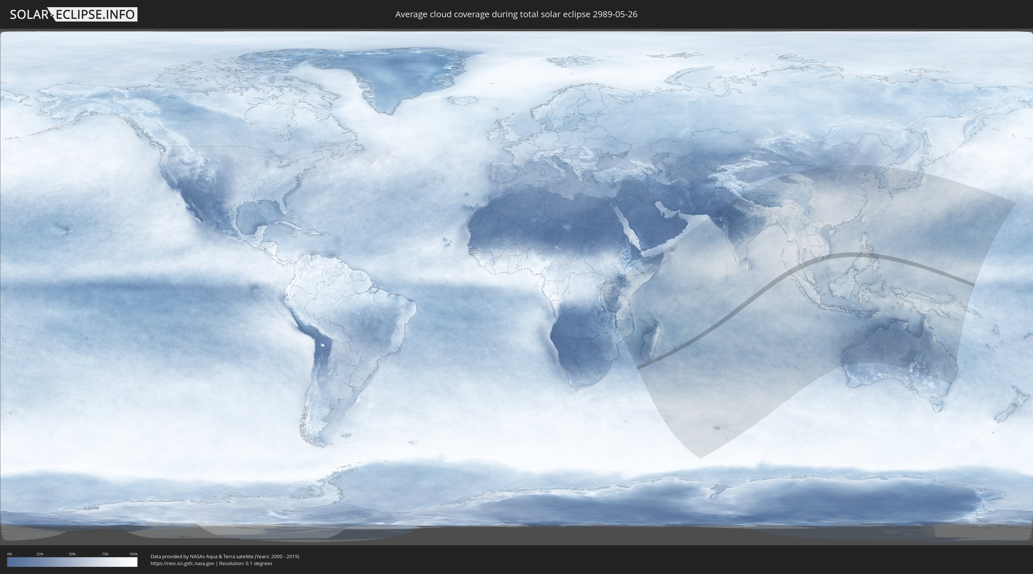
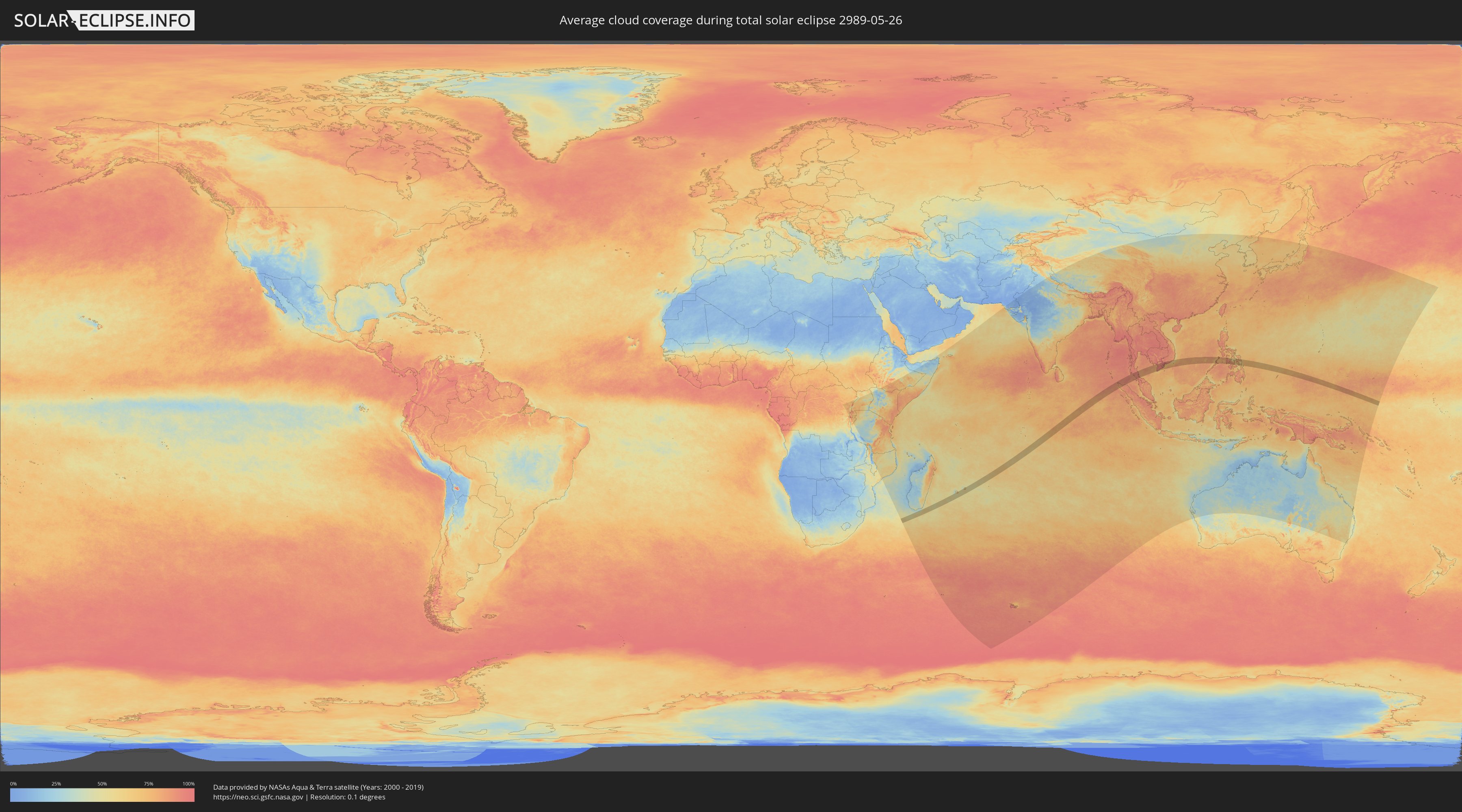
How will be the weather during the total solar eclipse on 05/26/2989?
Where is the best place to see the total solar eclipse of 05/26/2989?
The following maps show the average cloud coverage for the day of the total solar eclipse.
With the help of these maps, it is possible to find the place along the eclipse path, which has the best
chance of a cloudless sky.
Nevertheless, you should consider local circumstances and inform about the weather of your chosen
observation site.
The data is provided by NASAs satellites
AQUA and TERRA.
The cloud maps are averaged over a period of 19 years (2000 - 2019).
Detailed country maps
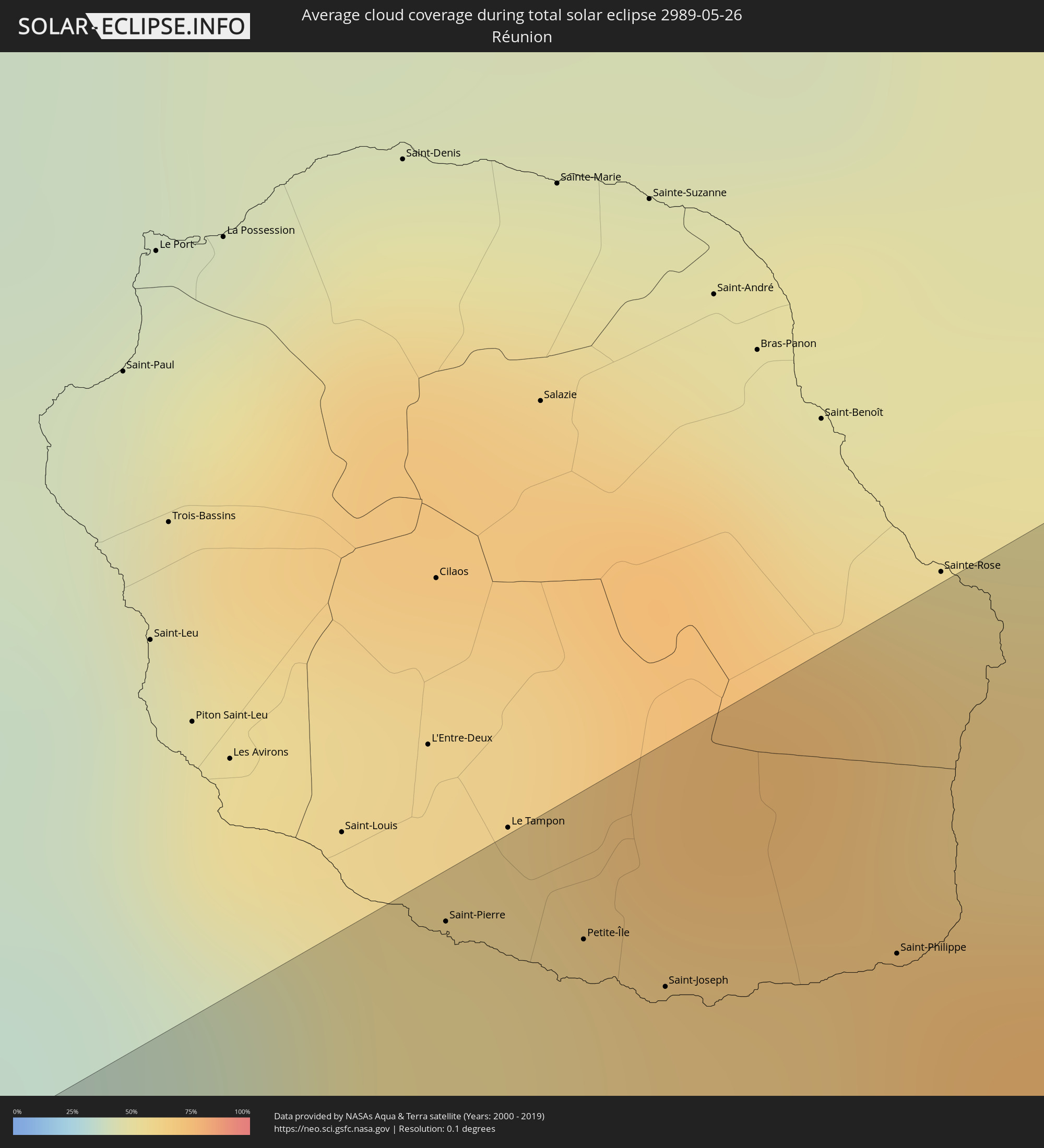 Réunion
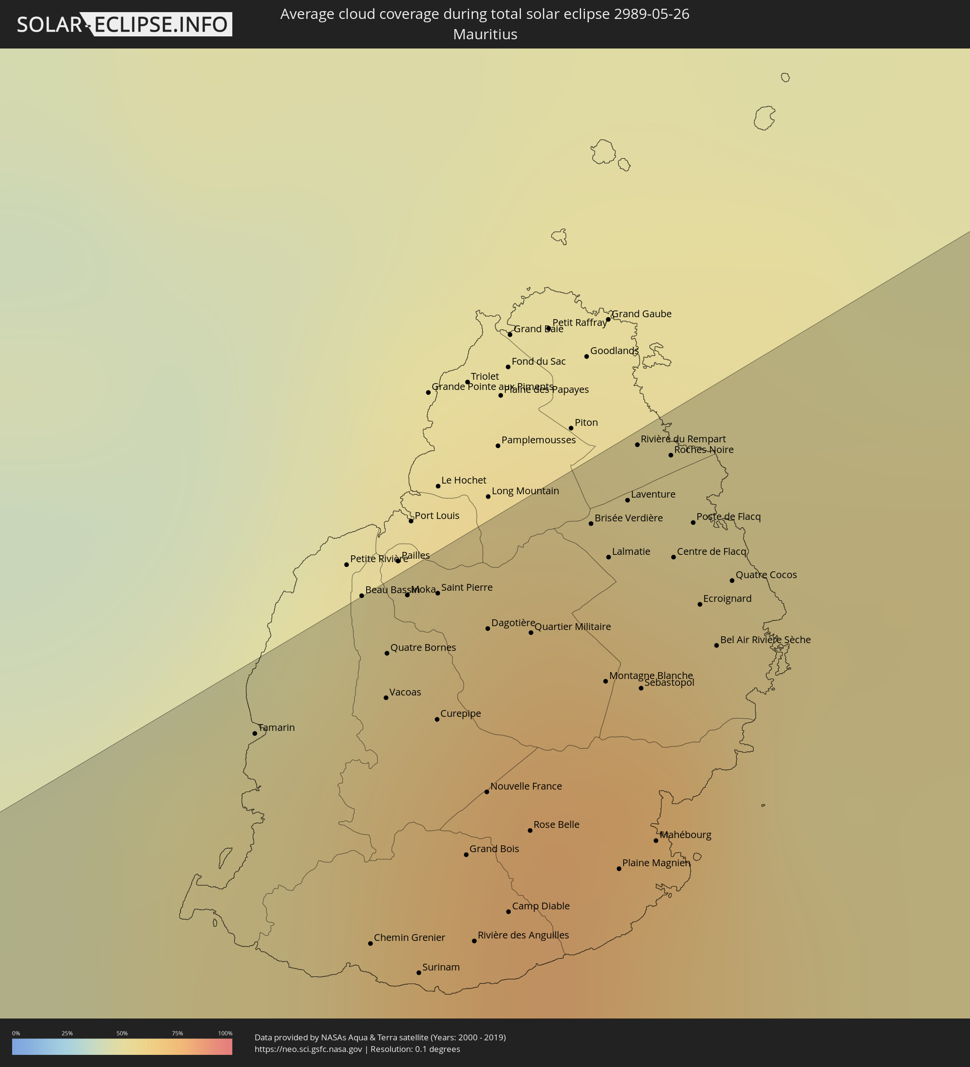 Mauritius
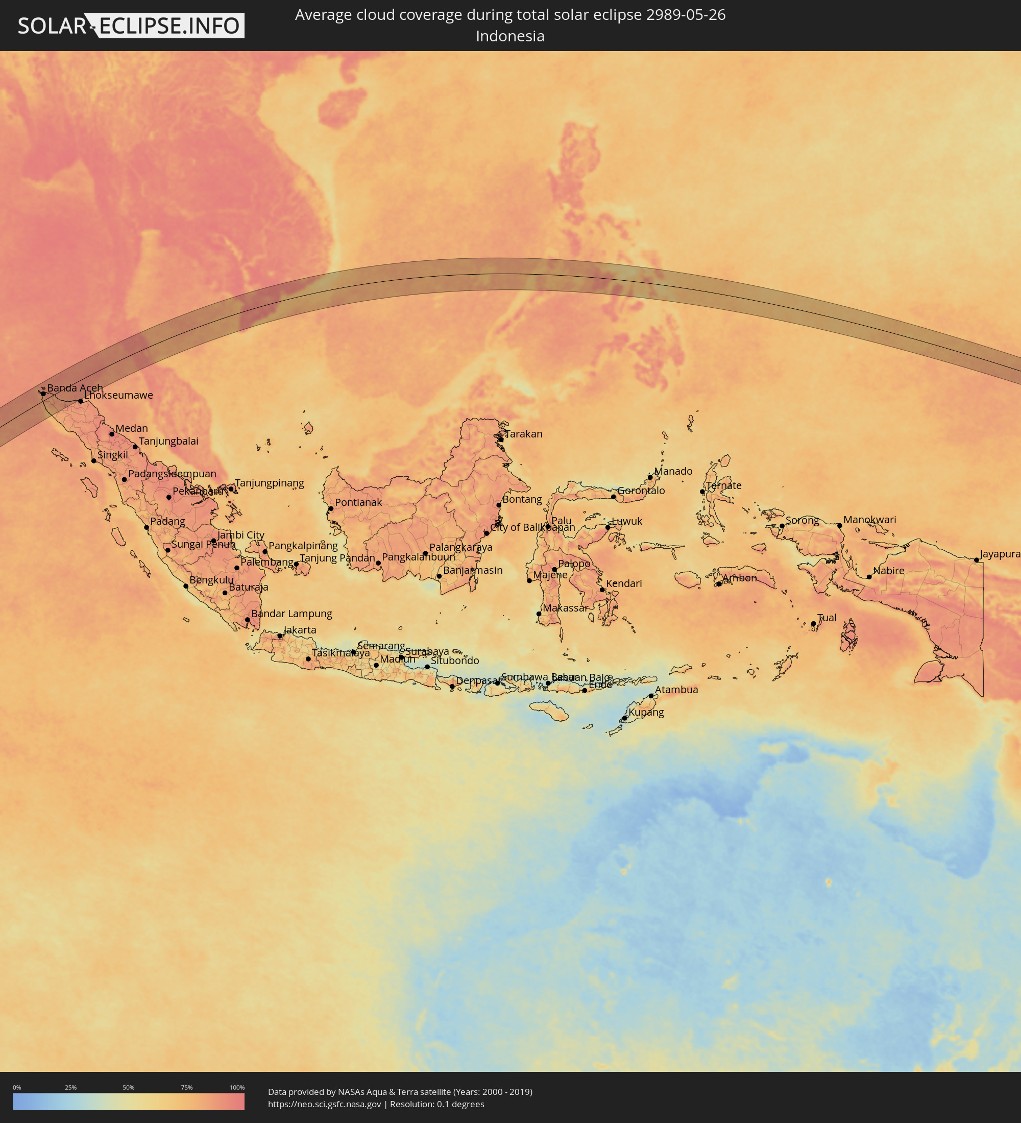 Indonesia
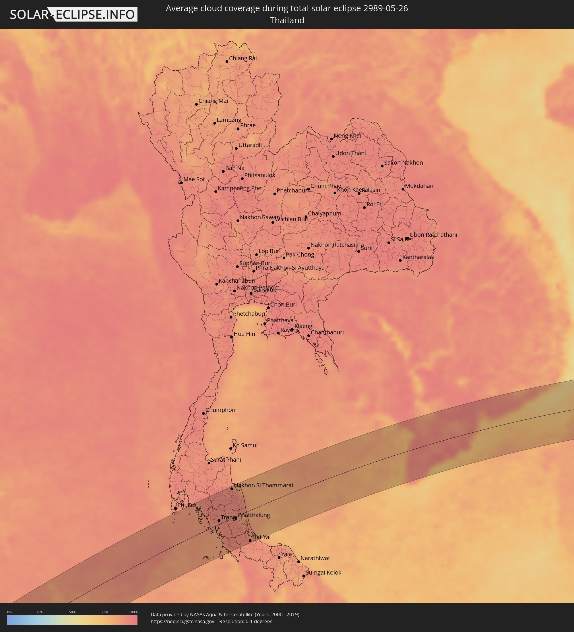 Thailand
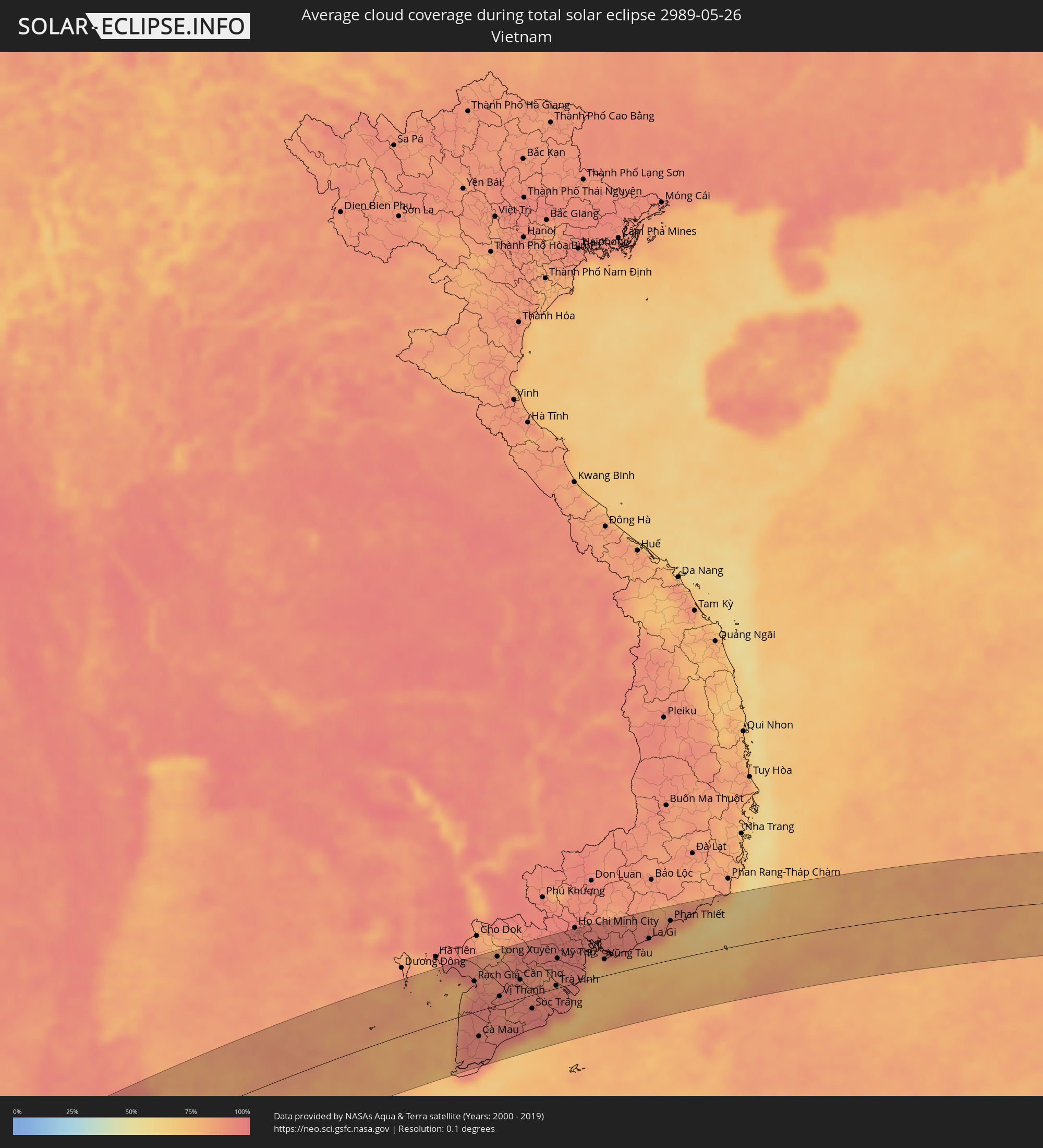 Vietnam
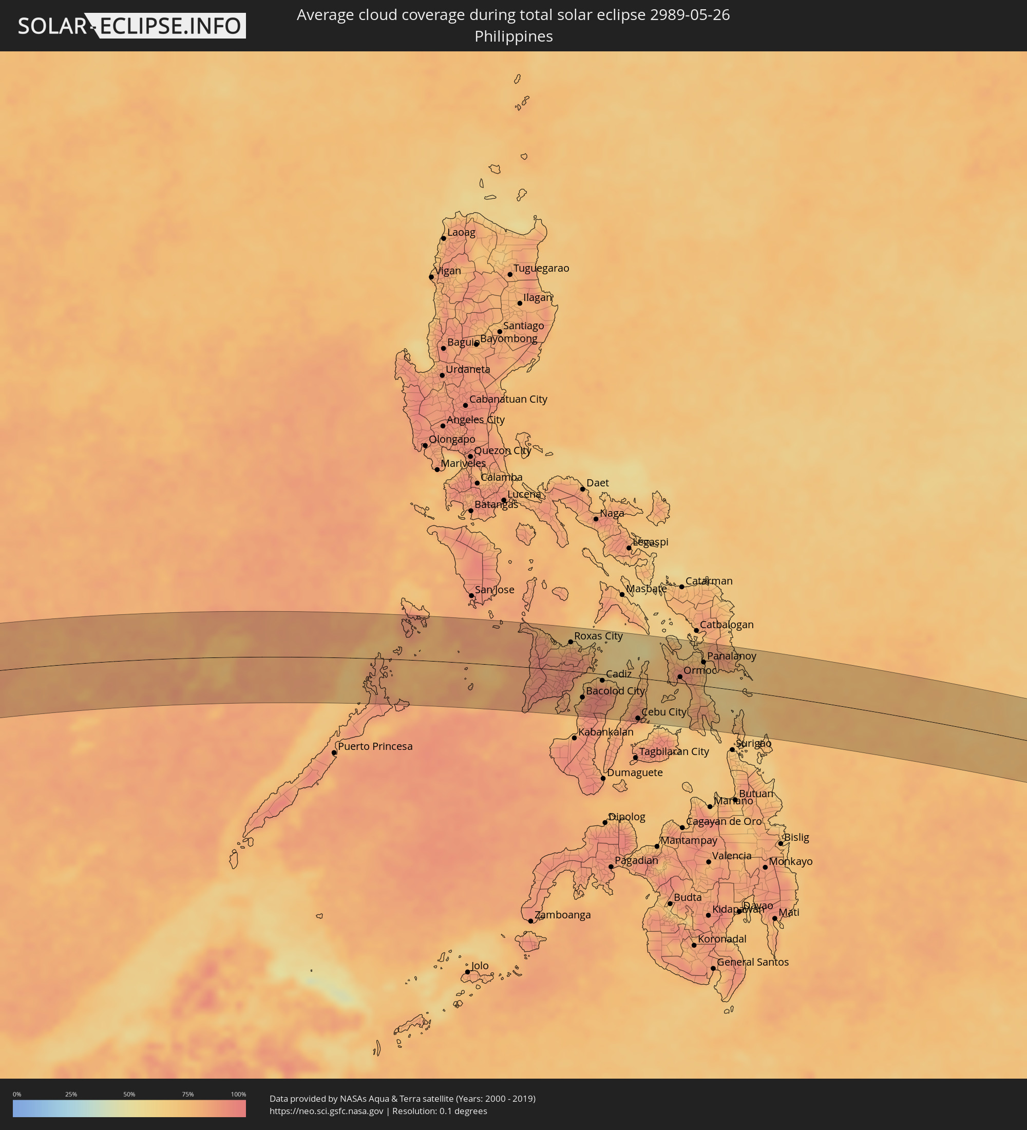 Philippines
Cities inside the path of the eclipse
The following table shows all locations with a population of more than 5,000 inside the eclipse path. Cities which have more than 100,000 inhabitants are marked bold. A click at the locations opens a detailed map.
| City | Type | Eclipse duration | Local time of max. eclipse | Distance to central line | Ø Cloud coverage |
|
Saint-Pierre, Réunion
|
total | - | 08:02:33 UTC+04:00 | 64 km | 50% |
|
Petite-Île, Réunion
|
total | - | 08:02:35 UTC+04:00 | 59 km | 57% |
|
Saint-Joseph, Réunion
|
total | - | 08:02:36 UTC+04:00 | 53 km | 57% |
|
Saint-Philippe, Réunion
|
total | - | 08:02:41 UTC+04:00 | 48 km | 61% |
|
Tamarin, Black River
|
total | - | 08:03:44 UTC+04:00 | 63 km | 57% |
|
Beau Bassin, Plaines Wilhems
|
total | - | 08:03:49 UTC+04:00 | 68 km | 67% |
|
Chemin Grenier, Savanne
|
total | - | 08:03:45 UTC+04:00 | 42 km | 55% |
|
Vacoas, Plaines Wilhems
|
total | - | 08:03:48 UTC+04:00 | 60 km | 70% |
|
Quatre Bornes, Plaines Wilhems
|
total | - | 08:03:49 UTC+04:00 | 63 km | 70% |
|
Moka, Moka
|
total | - | 08:03:50 UTC+04:00 | 67 km | 67% |
|
Surinam, Savanne
|
total | - | 08:03:46 UTC+04:00 | 38 km | 55% |
|
Souillac, Savanne
|
total | - | 08:03:46 UTC+04:00 | 37 km | 55% |
|
Curepipe, Plaines Wilhems
|
total | - | 08:03:49 UTC+04:00 | 56 km | 70% |
|
Saint Pierre, Moka
|
total | - | 08:03:51 UTC+04:00 | 65 km | 67% |
|
Grand Bois, Savanne
|
total | - | 08:03:49 UTC+04:00 | 45 km | 69% |
|
Rivière des Anguilles, Savanne
|
total | - | 08:03:48 UTC+04:00 | 38 km | 55% |
|
Nouvelle France, Grand Port
|
total | - | 08:03:50 UTC+04:00 | 49 km | 70% |
|
Dagotière, Moka
|
total | - | 08:03:52 UTC+04:00 | 61 km | 75% |
|
Camp Diable, Savanne
|
total | - | 08:03:49 UTC+04:00 | 39 km | 55% |
|
Rose Belle, Grand Port
|
total | - | 08:03:51 UTC+04:00 | 44 km | 70% |
|
Quartier Militaire, Moka
|
total | - | 08:03:53 UTC+04:00 | 58 km | 75% |
|
New Grove, Grand Port
|
total | - | 08:03:51 UTC+04:00 | 42 km | 70% |
|
Brisée Verdière, Flacq
|
total | - | 08:03:56 UTC+04:00 | 64 km | 75% |
|
Bon Accueil, Flacq
|
total | - | 08:03:56 UTC+04:00 | 63 km | 73% |
|
Montagne Blanche
|
total | - | 08:03:54 UTC+04:00 | 52 km | 68% |
|
Lalmatie, Flacq
|
total | - | 08:03:56 UTC+04:00 | 61 km | 73% |
|
Plaine Magnien, Grand Port
|
total | - | 08:03:53 UTC+04:00 | 37 km | 58% |
|
Laventure, Flacq
|
total | - | 08:03:57 UTC+04:00 | 64 km | 62% |
|
Rivière du Rempart, Rivière du Rempart
|
total | - | 08:03:58 UTC+04:00 | 68 km | 62% |
|
Sebastopol, Flacq
|
total | - | 08:03:55 UTC+04:00 | 49 km | 68% |
|
Beau Vallon, Grand Port
|
total | - | 08:03:54 UTC+04:00 | 37 km | 58% |
|
Mahébourg, Grand Port
|
total | - | 08:03:54 UTC+04:00 | 38 km | 58% |
|
Roches Noire, Rivière du Rempart
|
total | - | 08:03:59 UTC+04:00 | 65 km | 62% |
|
Centre de Flacq, Flacq
|
total | - | 08:03:58 UTC+04:00 | 58 km | 73% |
|
Poste de Flacq, Flacq
|
total | - | 08:03:59 UTC+04:00 | 59 km | 73% |
|
Ecroignard, Flacq
|
total | - | 08:03:58 UTC+04:00 | 53 km | 73% |
|
Bel Air Rivière Sèche, Flacq
|
total | - | 08:03:58 UTC+04:00 | 49 km | 68% |
|
Quatre Cocos, Flacq
|
total | - | 08:03:59 UTC+04:00 | 53 km | 55% |
|
Sabang, Aceh
|
total | - | 12:29:43 UTC+07:00 | 63 km | 86% |
|
Banda Aceh, Aceh
|
total | - | 12:29:16 UTC+07:00 | 29 km | 85% |
|
Sigli, Aceh
|
total | - | 12:30:46 UTC+07:00 | 21 km | 83% |
|
Reuleuet, Aceh
|
total | - | 12:31:26 UTC+07:00 | 55 km | 87% |
|
Bireun, Aceh
|
total | - | 12:32:36 UTC+07:00 | 79 km | 88% |
|
Nuea Khlong, Krabi
|
total | - | 12:43:06 UTC+07:00 | 90 km | 91% |
|
Saladan, Krabi
|
total | - | 12:42:36 UTC+07:00 | 42 km | 87% |
|
Ko Lanta, Krabi
|
total | - | 12:42:38 UTC+07:00 | 32 km | 87% |
|
Kantang, Trang
|
total | - | 12:43:42 UTC+07:00 | 2 km | 87% |
|
Trang, Trang
|
total | - | 12:44:11 UTC+07:00 | 9 km | 94% |
|
Huai Yot, Trang
|
total | - | 12:44:34 UTC+07:00 | 32 km | 93% |
|
Thung Song, Nakhon Si Thammarat
|
total | - | 12:45:11 UTC+07:00 | 68 km | 95% |
|
Ron Phibun, Nakhon Si Thammarat
|
total | - | 12:45:42 UTC+07:00 | 61 km | 93% |
|
Nakhon Si Thammarat, Nakhon Si Thammarat
|
total | - | 12:46:21 UTC+07:00 | 82 km | 95% |
|
Phatthalung, Phatthalung
|
total | - | 12:45:37 UTC+07:00 | 6 km | 92% |
|
Pak Phanang, Nakhon Si Thammarat
|
total | - | 12:46:56 UTC+07:00 | 63 km | 89% |
|
Ranot, Songkhla
|
total | - | 12:46:32 UTC+07:00 | 1 km | 89% |
|
Hat Yai, Songkhla
|
total | - | 12:45:59 UTC+07:00 | 86 km | 91% |
|
Ban Mai, Songkhla
|
total | - | 12:46:27 UTC+07:00 | 69 km | 86% |
|
Songkhla, Songkhla
|
total | - | 12:46:35 UTC+07:00 | 72 km | 87% |
|
Rạch Giá, Kiến Giang
|
total | - | 13:03:02 UTC+07:00 | 50 km | 91% |
|
Cà Mau, Cà Mau
|
total | - | 13:02:21 UTC+07:00 | 42 km | 95% |
|
Long Xuyên, An Giang
|
total | - | 13:04:26 UTC+07:00 | 78 km | 88% |
|
Vị Thanh, Hau Giang
|
total | - | 13:03:55 UTC+07:00 | 13 km | 92% |
|
Cao Lãnh, Đồng Tháp
|
total | - | 13:05:05 UTC+07:00 | 80 km | 89% |
|
Thành phố Bạc Liêu, Bạc Liêu
|
total | - | 13:04:09 UTC+07:00 | 47 km | 93% |
|
Sadek, Đồng Tháp
|
total | - | 13:05:16 UTC+07:00 | 58 km | 93% |
|
Cần Thơ, Cần Thơ
|
total | - | 13:05:06 UTC+07:00 | 30 km | 93% |
|
Sóc Trăng, Sóc Trăng
|
total | - | 13:05:11 UTC+07:00 | 22 km | 97% |
|
Vĩnh Long, Vĩnh Long
|
total | - | 13:05:51 UTC+07:00 | 48 km | 88% |
|
Ấp Tân Ngãi, Bến Tre
|
total | - | 13:06:43 UTC+07:00 | 37 km | 89% |
|
Trà Vinh, Trà Vinh
|
total | - | 13:06:36 UTC+07:00 | 4 km | 94% |
|
Mỹ Tho, Tiền Giang
|
total | - | 13:07:04 UTC+07:00 | 48 km | 92% |
|
Bến Tre, Bến Tre
|
total | - | 13:06:59 UTC+07:00 | 35 km | 89% |
|
Tân An, Long An
|
total | - | 13:07:23 UTC+07:00 | 66 km | 95% |
|
Cần Giuộc, Long An
|
total | - | 13:08:12 UTC+07:00 | 66 km | 94% |
|
Cần Giờ, Ho Chi Minh City
|
total | - | 13:08:49 UTC+07:00 | 37 km | 73% |
|
Vũng Tàu, Bà Rịa-Vũng Tàu
|
total | - | 13:09:07 UTC+07:00 | 27 km | 73% |
|
Thành Phố Bà Rịa, Bà Rịa-Vũng Tàu
|
total | - | 13:09:30 UTC+07:00 | 41 km | 88% |
|
La Gi, Bình Thuận
|
total | - | 13:11:22 UTC+07:00 | 43 km | 82% |
|
Phan Thiết, Bình Thuận
|
total | - | 13:12:32 UTC+07:00 | 64 km | 79% |
|
Pandan, Western Visayas
|
total | - | 14:47:37 UTC+08:00 | 64 km | 85% |
|
Kalibo (poblacion), Western Visayas
|
total | - | 14:48:09 UTC+08:00 | 63 km | 76% |
|
Tigbauan, Western Visayas
|
total | - | 14:47:55 UTC+08:00 | 52 km | 80% |
|
Janiuay, Western Visayas
|
total | - | 14:48:15 UTC+08:00 | 20 km | 91% |
|
Iloilo, Western Visayas
|
total | - | 14:48:19 UTC+08:00 | 47 km | 83% |
|
Passi, Western Visayas
|
total | - | 14:48:34 UTC+08:00 | 1 km | 94% |
|
Barotac Nuevo, Western Visayas
|
total | - | 14:48:39 UTC+08:00 | 24 km | 84% |
|
Roxas City, Western Visayas
|
total | - | 14:48:54 UTC+08:00 | 53 km | 82% |
|
Bago City, Western Visayas
|
total | - | 14:48:49 UTC+08:00 | 63 km | 76% |
|
La Carlota, Western Visayas
|
total | - | 14:48:58 UTC+08:00 | 74 km | 83% |
|
Bacolod City, Western Visayas
|
total | - | 14:49:05 UTC+08:00 | 47 km | 90% |
|
Victorias, Western Visayas
|
total | - | 14:49:23 UTC+08:00 | 20 km | 87% |
|
Estancia, Western Visayas
|
total | - | 14:49:40 UTC+08:00 | 43 km | 71% |
|
Canlaon, Central Visayas
|
total | - | 14:49:34 UTC+08:00 | 75 km | 87% |
|
Cadiz, Western Visayas
|
total | - | 14:49:49 UTC+08:00 | 12 km | 90% |
|
Ualog, Western Visayas
|
total | - | 14:49:57 UTC+08:00 | 52 km | 80% |
|
Escalante, Western Visayas
|
total | - | 14:50:13 UTC+08:00 | 22 km | 77% |
|
Toledo, Central Visayas
|
total | - | 14:50:23 UTC+08:00 | 71 km | 78% |
|
Balamban, Central Visayas
|
total | - | 14:50:34 UTC+08:00 | 56 km | 82% |
|
Bantayan, Central Visayas
|
total | - | 14:50:43 UTC+08:00 | 17 km | 69% |
|
Cebu City, Central Visayas
|
total | - | 14:50:52 UTC+08:00 | 75 km | 78% |
|
Bogo, Central Visayas
|
total | - | 14:51:15 UTC+08:00 | 8 km | 76% |
|
Daanbantayan, Central Visayas
|
total | - | 14:51:18 UTC+08:00 | 30 km | 73% |
|
Danao, Central Visayas
|
total | - | 14:51:11 UTC+08:00 | 51 km | 73% |
|
Palompon, Eastern Visayas
|
total | - | 14:51:58 UTC+08:00 | 13 km | 77% |
|
Naval, Eastern Visayas
|
total | - | 14:52:05 UTC+08:00 | 69 km | 72% |
|
Ormoc, Eastern Visayas
|
total | - | 14:52:23 UTC+08:00 | 11 km | 73% |
|
Carigara, Eastern Visayas
|
total | - | 14:52:34 UTC+08:00 | 44 km | 84% |
|
Baybay, Eastern Visayas
|
total | - | 14:52:41 UTC+08:00 | 23 km | 73% |
|
Burauen, Eastern Visayas
|
total | - | 14:52:55 UTC+08:00 | 11 km | 75% |
|
Panalanoy, Eastern Visayas
|
total | - | 14:53:10 UTC+08:00 | 43 km | 71% |
|
Abuyog, Eastern Visayas
|
total | - | 14:53:05 UTC+08:00 | 13 km | 77% |
|
Tanauan, Eastern Visayas
|
total | - | 14:53:10 UTC+08:00 | 28 km | 70% |
|
Guiuan, Eastern Visayas
|
total | - | 14:54:26 UTC+08:00 | 29 km | 65% |