Totale Sonnenfinsternis vom 15.04.-0135
| Wochentag: | Donnerstag |
| Maximale Dauer der Verfinsterung: | 03m39s |
| Maximale Breite des Finsternispfades: | 244 km |
| Saroszyklus: | 75 |
| Bedeckungsgrad: | 100% |
| Magnitude: | 1.0526 |
| Gamma: | 0.7119 |
Wo kann man die Sonnenfinsternis vom 15.04.-0135 sehen?
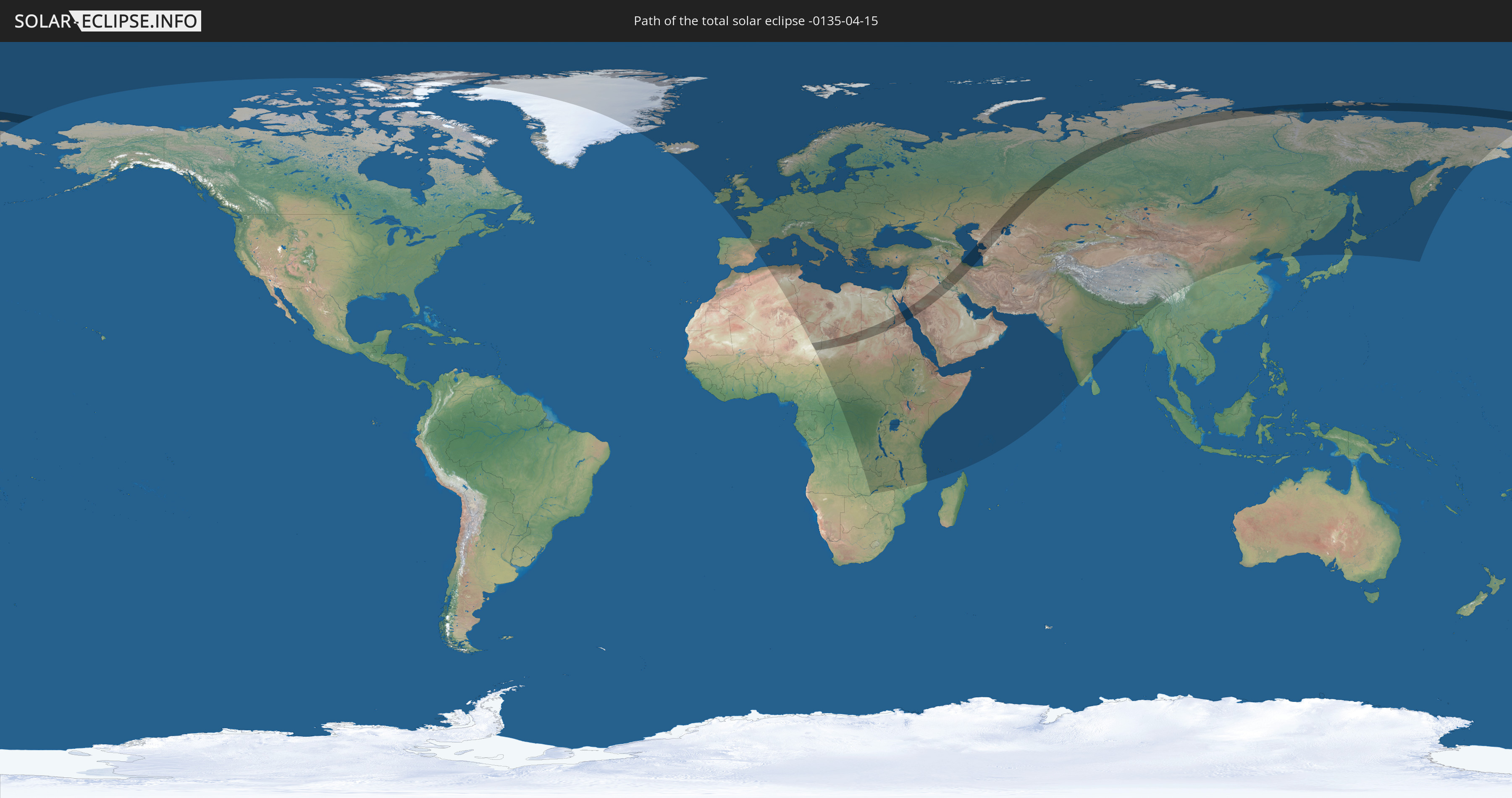
Die Sonnenfinsternis am 15.04.-0135 kann man in 112 Ländern als partielle Sonnenfinsternis beobachten.
Der Finsternispfad verläuft durch 12 Länder. Nur in diesen Ländern ist sie als totale Sonnenfinsternis zu sehen.
In den folgenden Ländern ist die Sonnenfinsternis total zu sehen
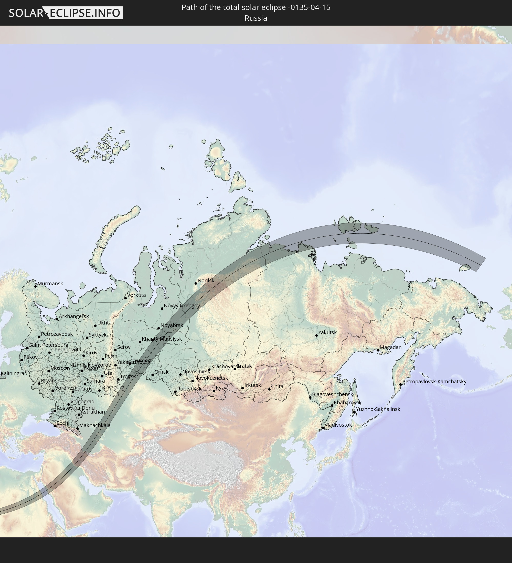 Russland
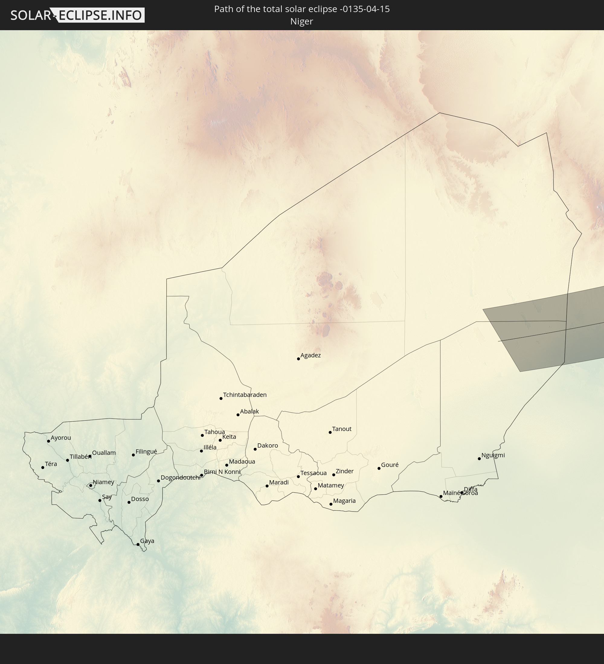 Niger
Niger
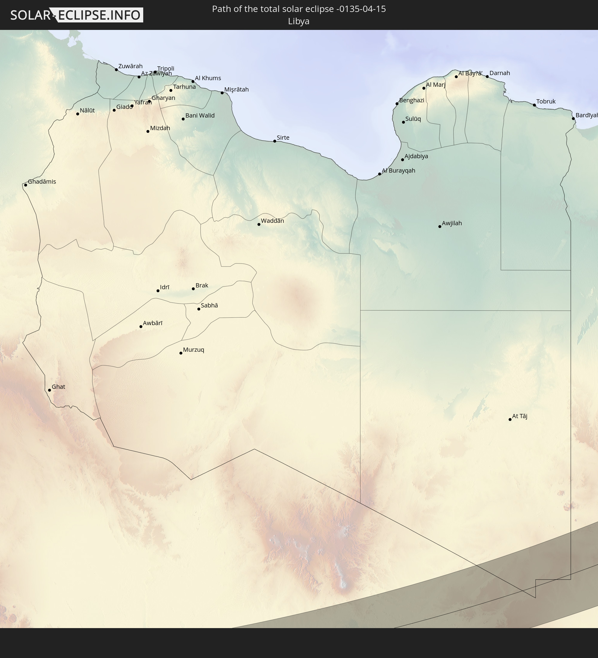 Libyen
 Tschad
 Sudan
Sudan
 Ägypten
 Saudi-Arabien
 Irak
Irak
 Iran
Iran
 Kasachstan
 Turkmenistan
 Usbekistan
In den folgenden Ländern ist die Sonnenfinsternis partiell zu sehen
 Russland
 Kanada
 Grönland
 Island
 Spanien
 Irland
 Spitzbergen
 Algerien
 Vereinigtes Königreich
 Färöer
 Frankreich
 Isle of Man
 Guernsey
 Jersey
 Niger
Niger
 Andorra
 Belgien
 Niederlande
 Norwegen
 Luxemburg
 Deutschland
 Schweiz
 Italien
 Monaco
 Tunesien
 Dänemark
 Libyen
 Liechtenstein
 Österreich
 Schweden
 Tschechien
 Demokratische Republik Kongo
 San Marino
 Vatikanstadt
 Slowenien
 Tschad
 Kroatien
 Polen
Polen
 Malta
Malta
 Zentralafrikanische Republik
 Bosnien und Herzegowina
 Ungarn
 Slowakei
 Montenegro
 Serbien
 Albanien
 Åland Islands
 Griechenland
 Rumänien
 Mazedonien
 Finnland
 Litauen
 Lettland
 Estland
 Sudan
Sudan
 Sambia
 Ukraine
 Bulgarien
 Weißrussland
 Ägypten
 Simbabwe
 Türkei
 Moldawien
 Ruanda
 Burundi
 Tansania
 Uganda
 Mosambik
 Republik Zypern
 Malawi
 Äthiopien
 Kenia
Kenia
 Staat Palästina
 Israel
 Saudi-Arabien
 Jordanien
 Libanon
 Syrien
 Eritrea
 Irak
Irak
 Georgien
 Französische Süd- und Antarktisgebiete
 Somalia
 Dschibuti
 Jemen
Jemen
 Komoren
 Armenien
 Iran
Iran
 Aserbaidschan
 Mayotte
 Seychellen
 Kasachstan
 Kuwait
 Bahrain
 Katar
Katar
 Vereinigte Arabische Emirate
 Oman
Oman
 Turkmenistan
 Usbekistan
 Afghanistan
 Pakistan
 Tadschikistan
 Indien
 Kirgisistan
 Malediven
 Volksrepublik China
 Nepal
Nepal
 Mongolei
 Bangladesch
 Bhutan
 Japan
Japan
 Nordkorea
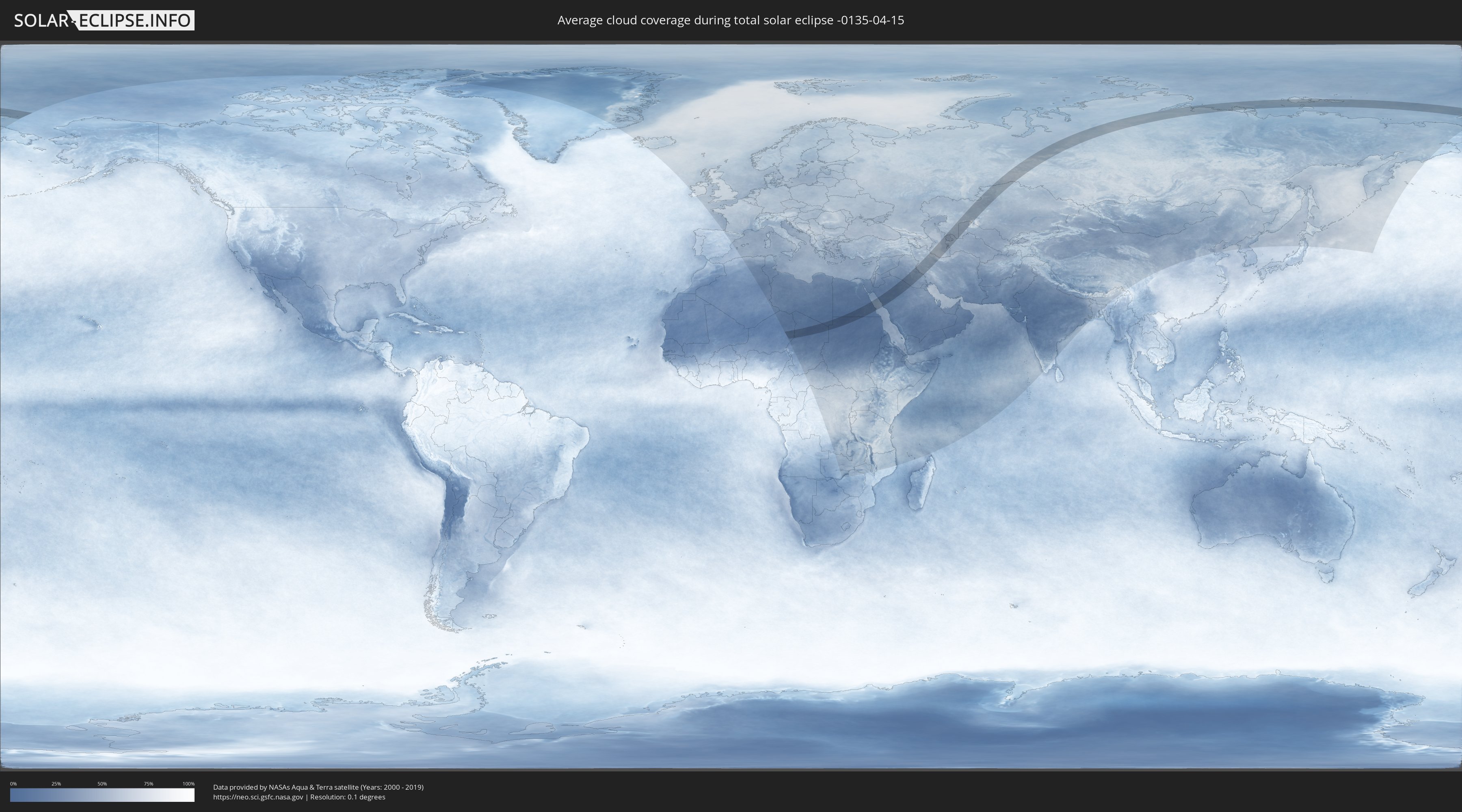
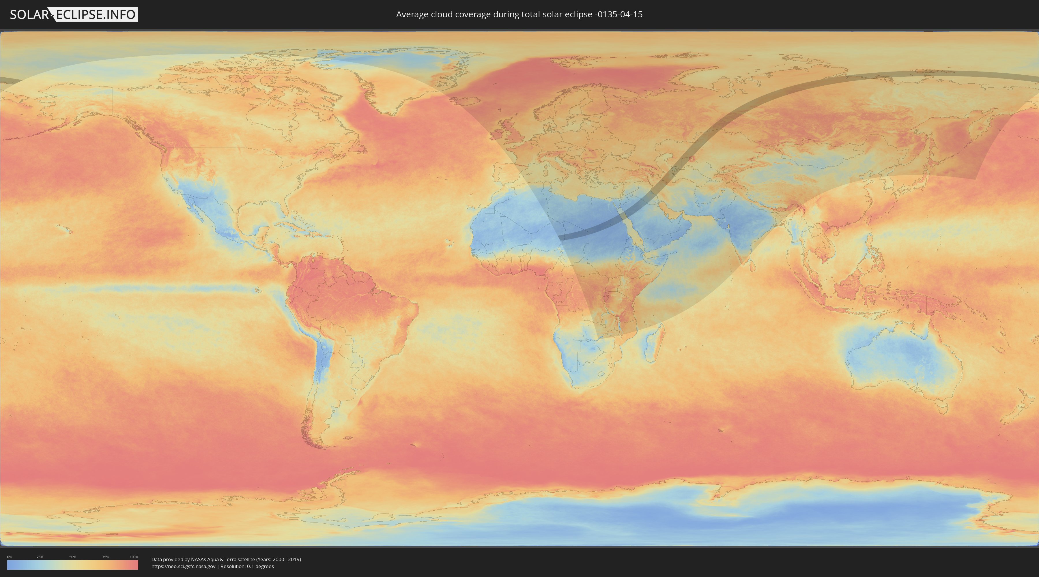
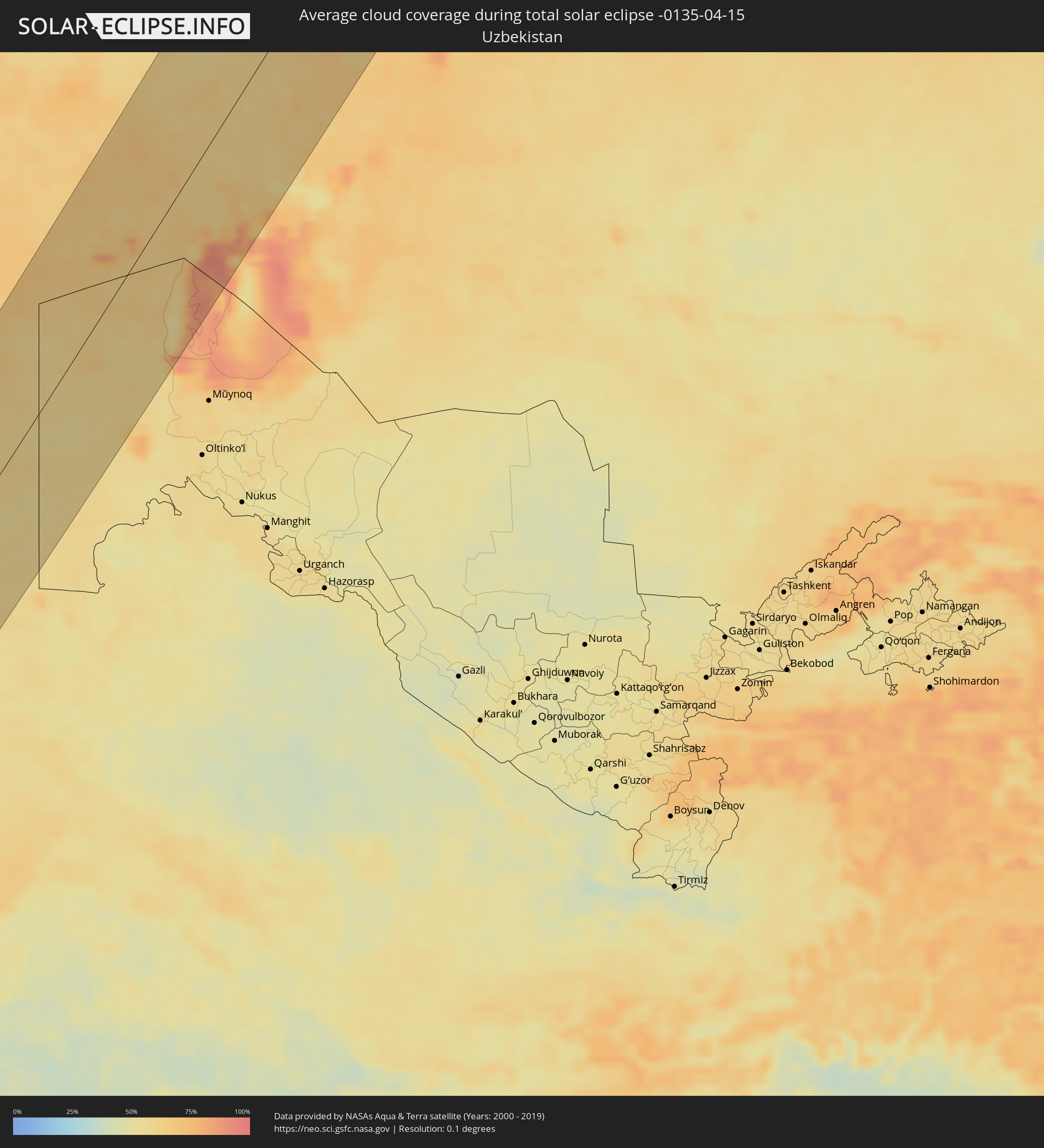
Wie wird das Wetter während der totalen Sonnenfinsternis am 15.04.-0135?
Wo ist der beste Ort, um die totale Sonnenfinsternis vom 15.04.-0135 zu beobachten?
Die folgenden Karten zeigen die durchschnittliche Bewölkung für den Tag, an dem die totale Sonnenfinsternis
stattfindet. Mit Hilfe der Karten lässt sich der Ort entlang des Finsternispfades eingrenzen,
der die besten Aussichen auf einen klaren wolkenfreien Himmel bietet.
Trotzdem muss man immer lokale Gegenenheiten beachten und sollte sich genau über das Wetter an seinem
gewählten Beobachtungsort informieren.
Die Daten stammen von den beiden NASA-Satelliten
AQUA und TERRA
und wurden über einen Zeitraum von 19 Jahren (2000 - 2019) gemittelt.
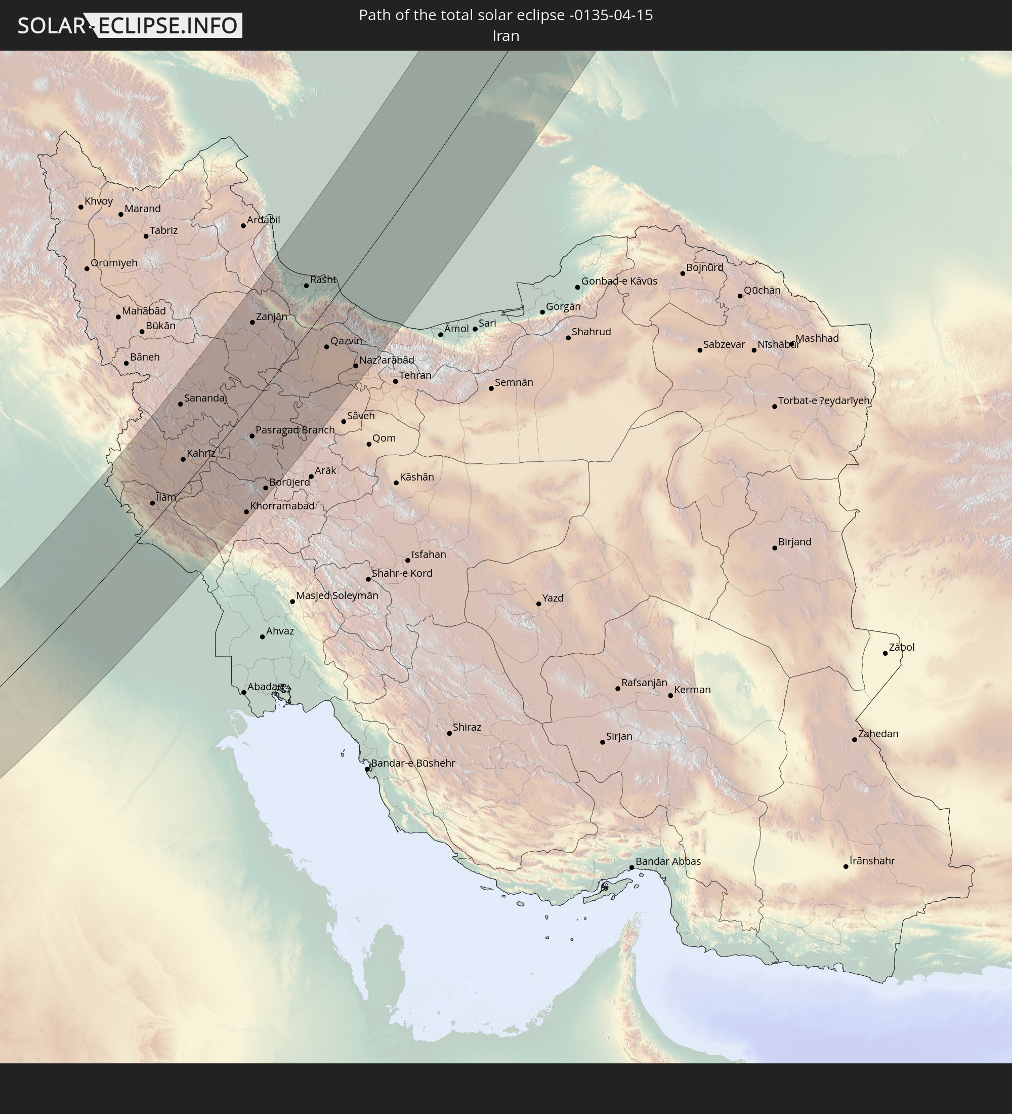
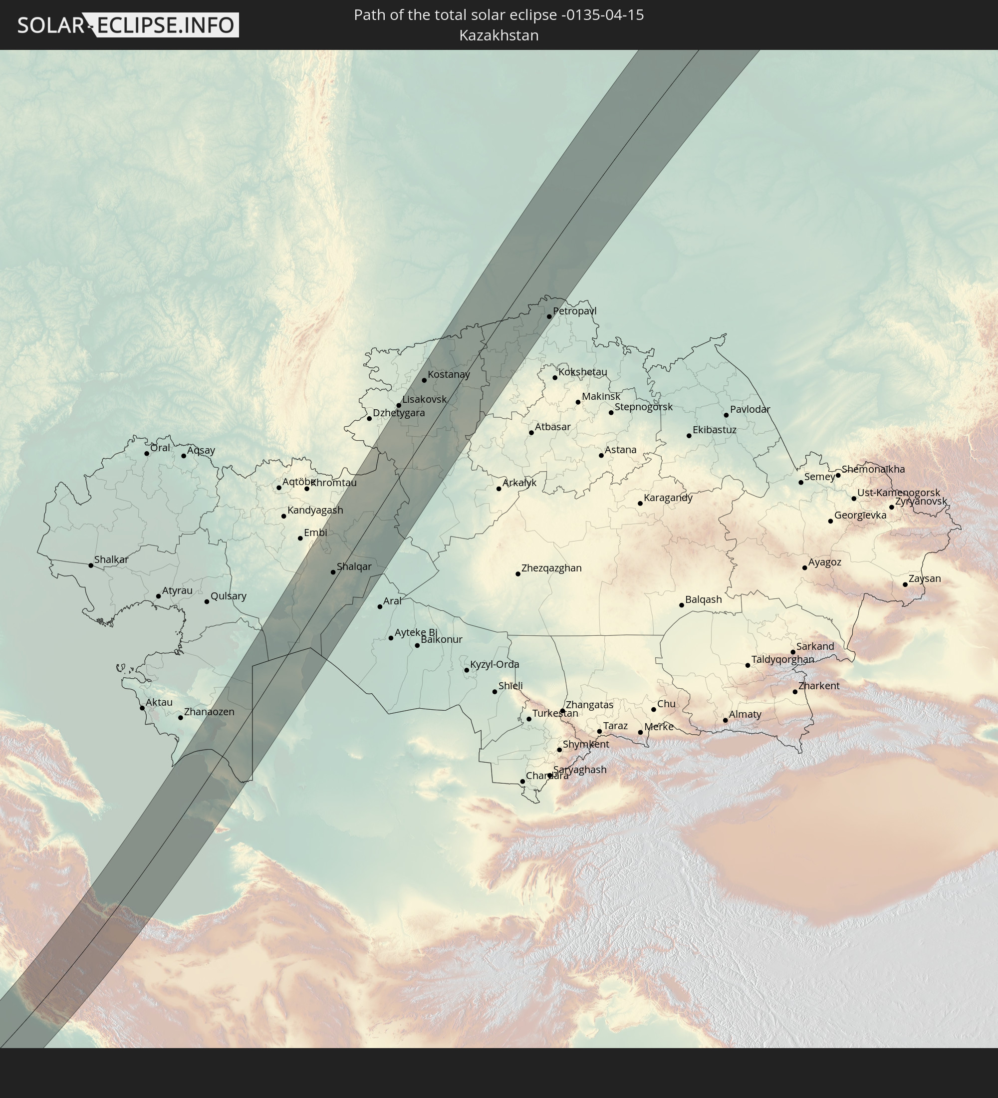
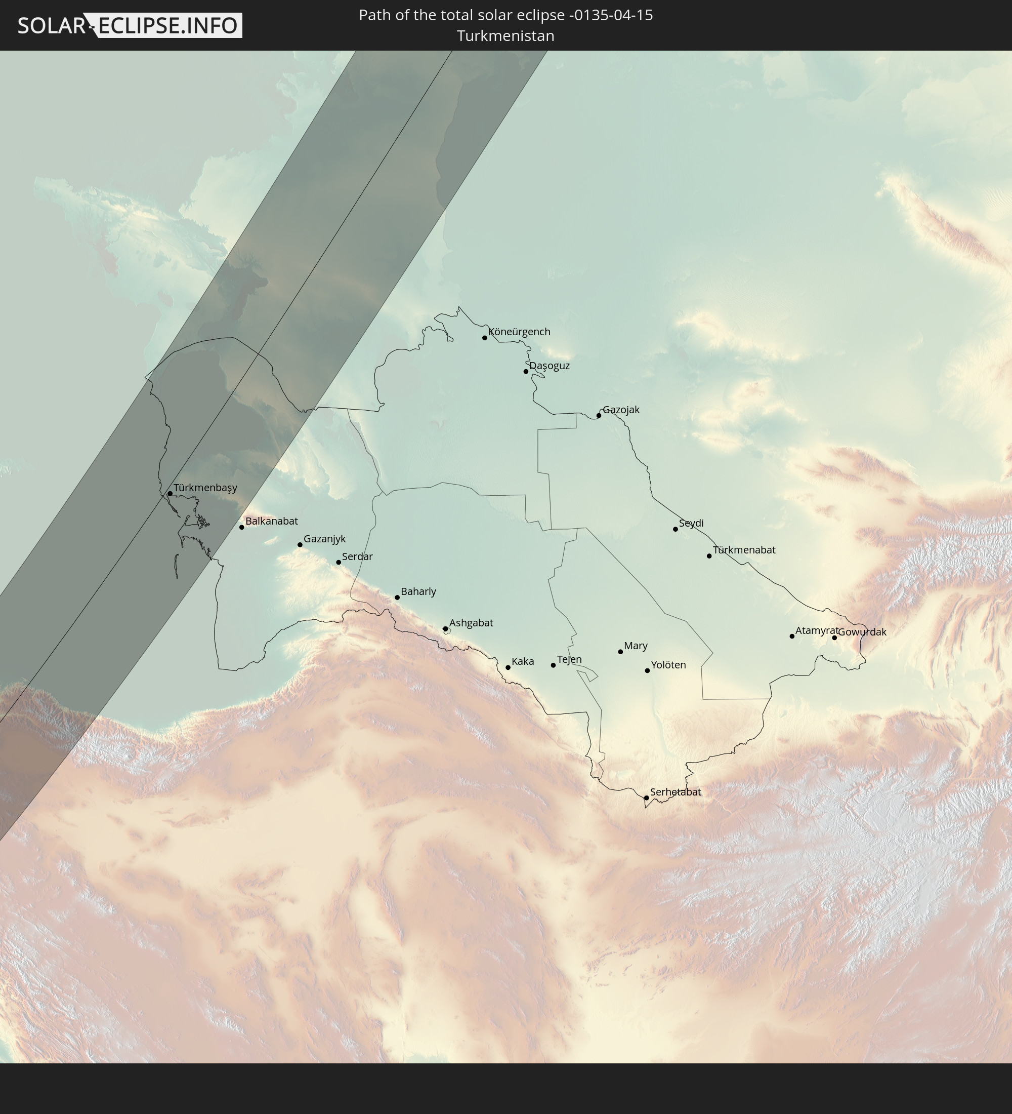
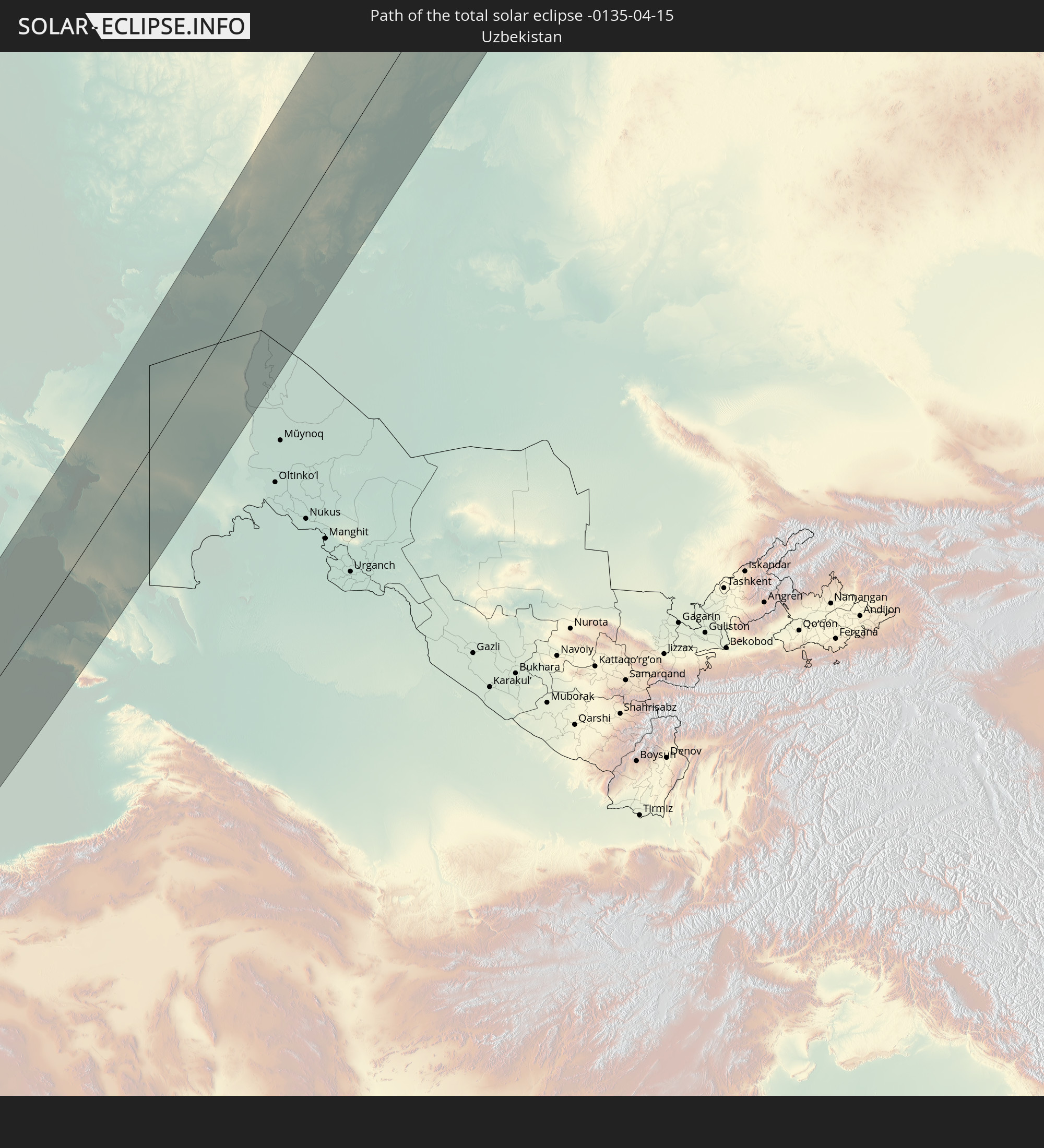
Detaillierte Länderkarten
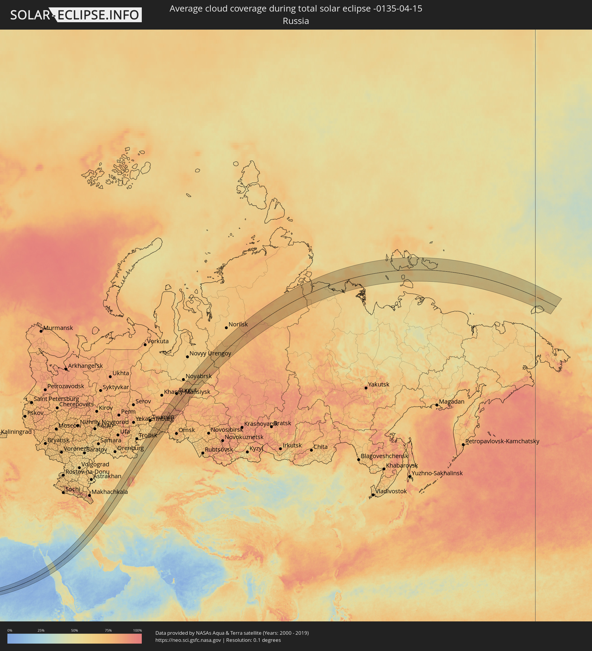 Russland
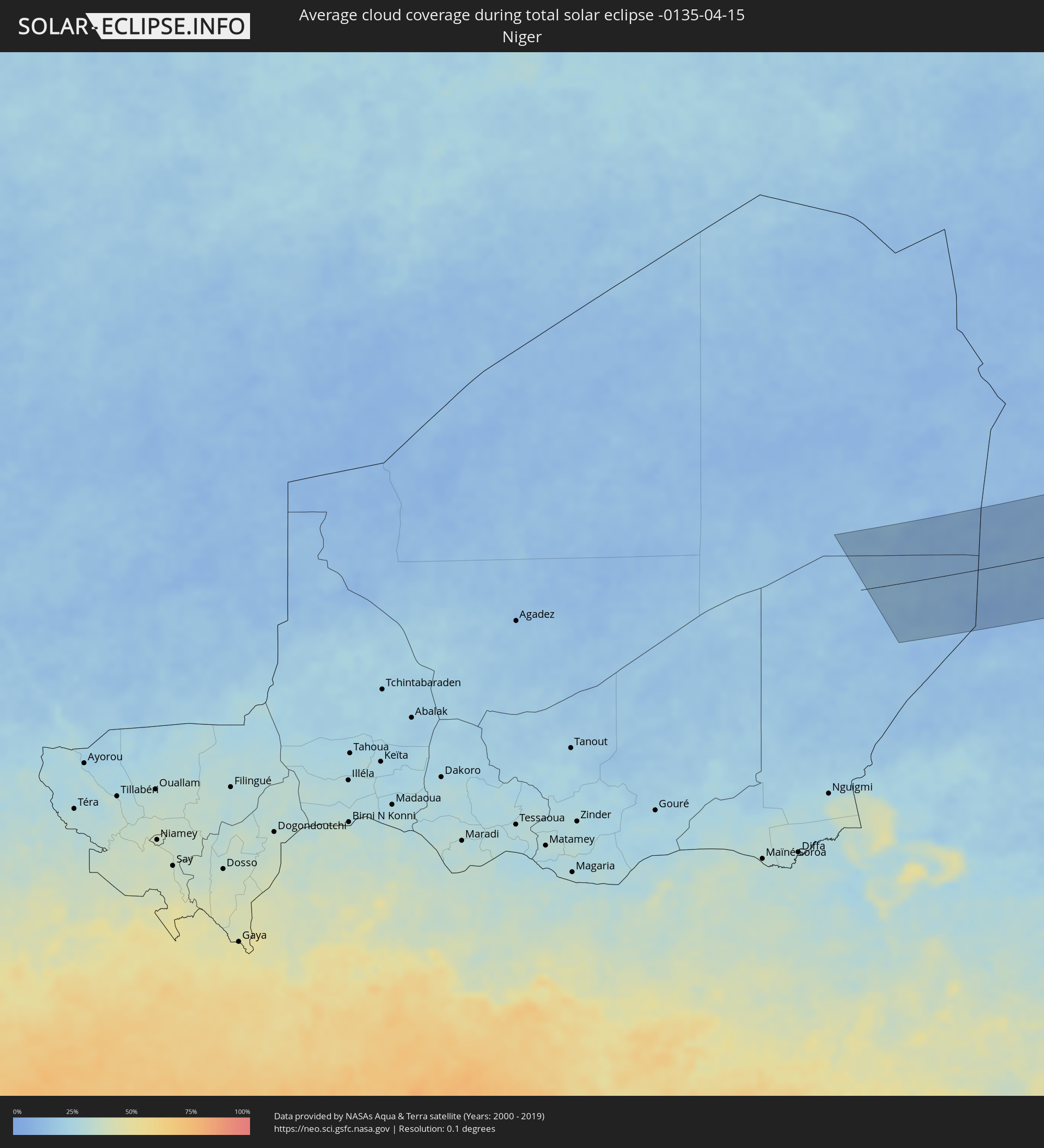 Niger
Niger
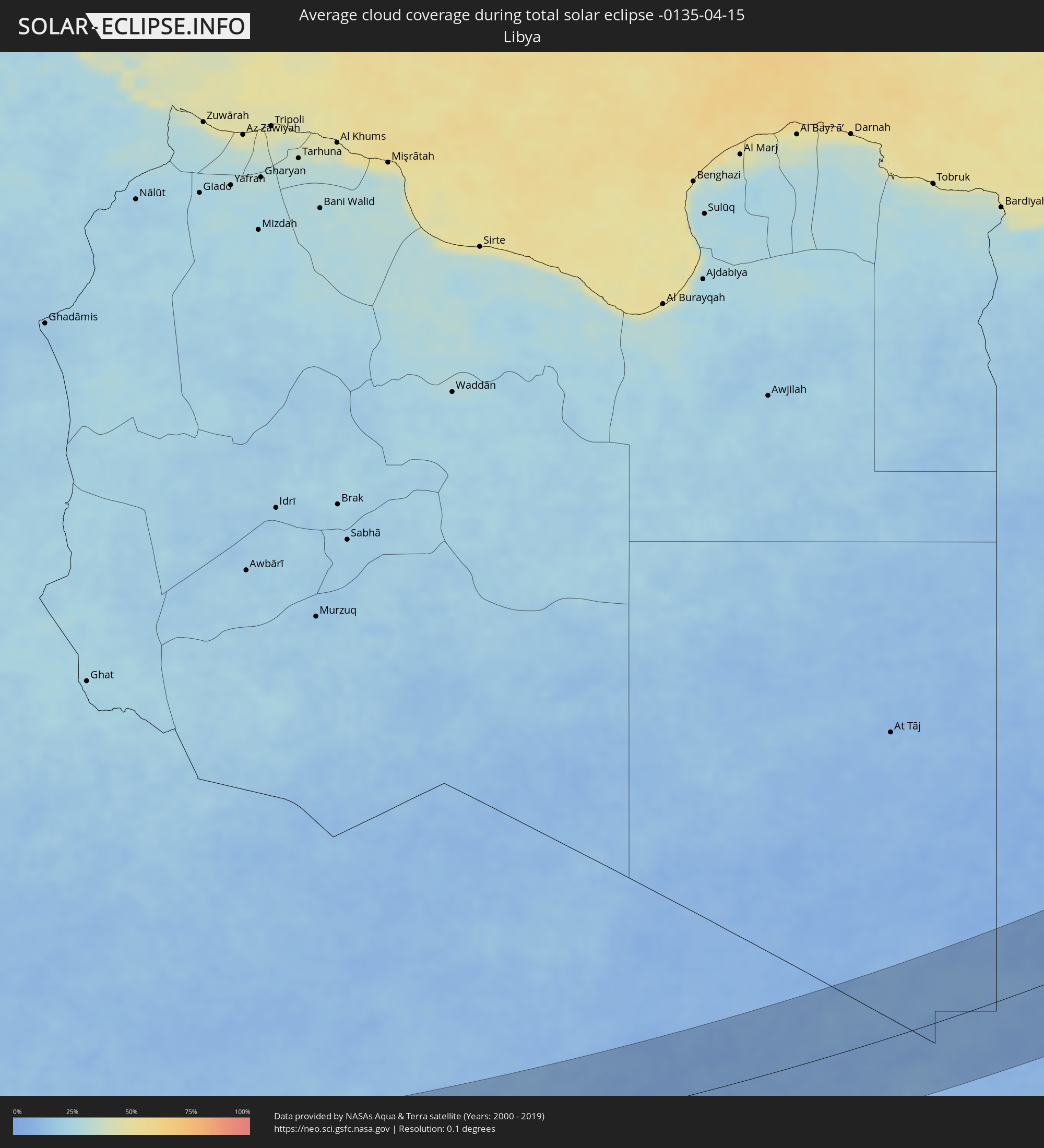 Libyen
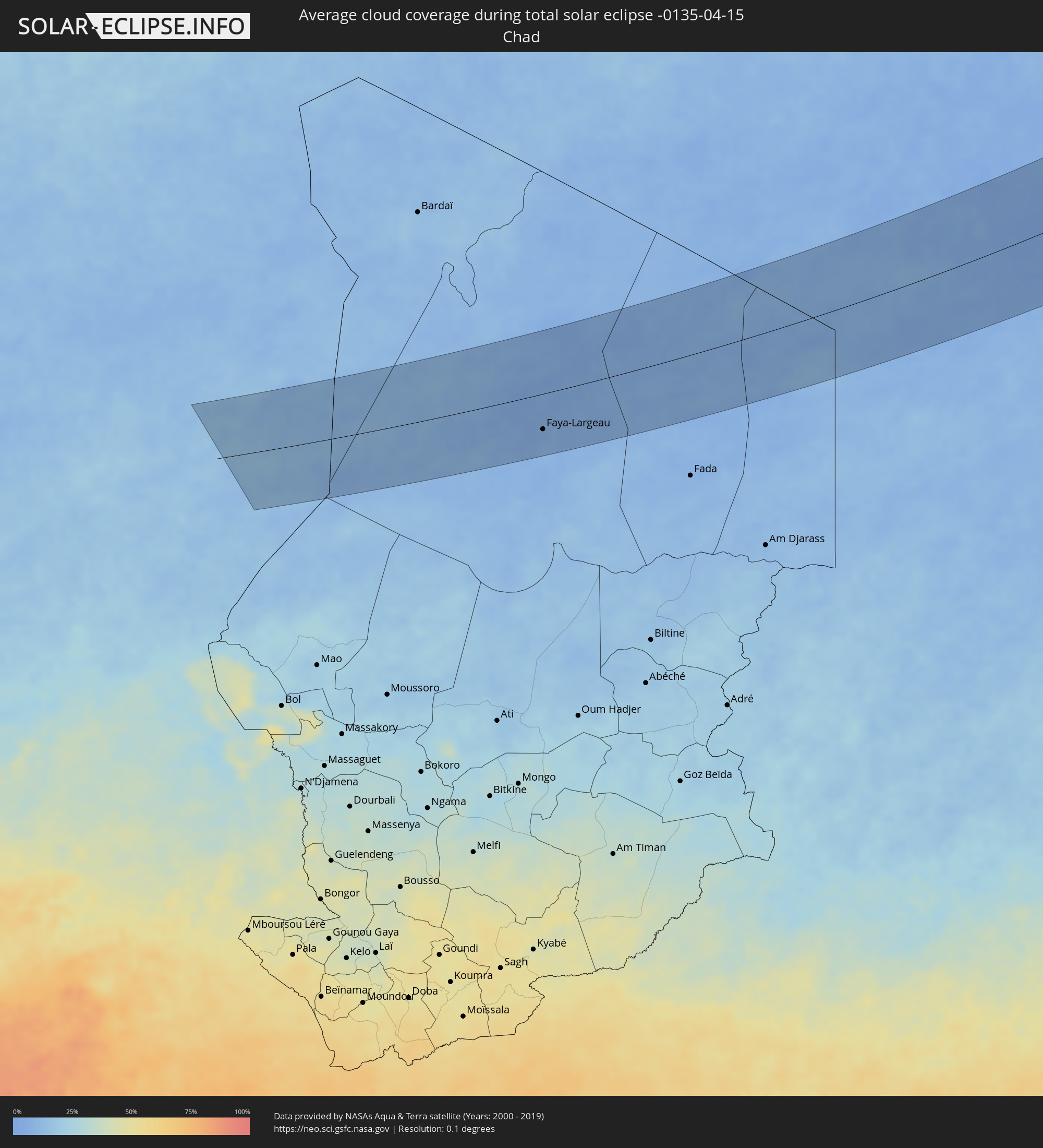 Tschad
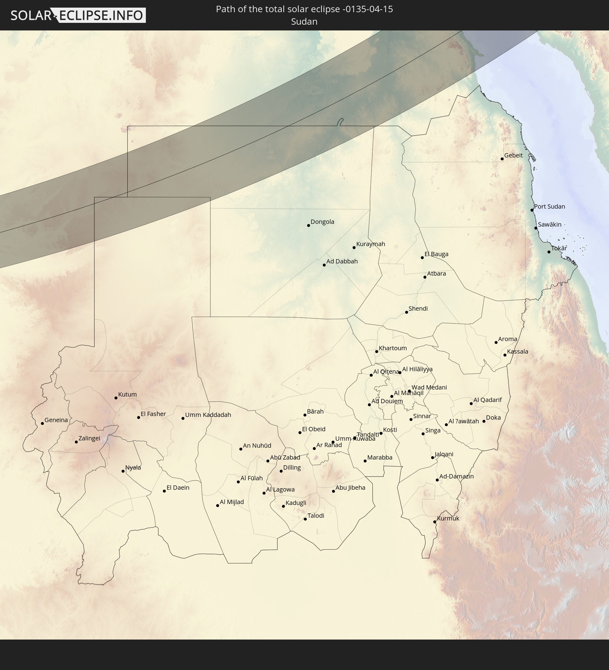
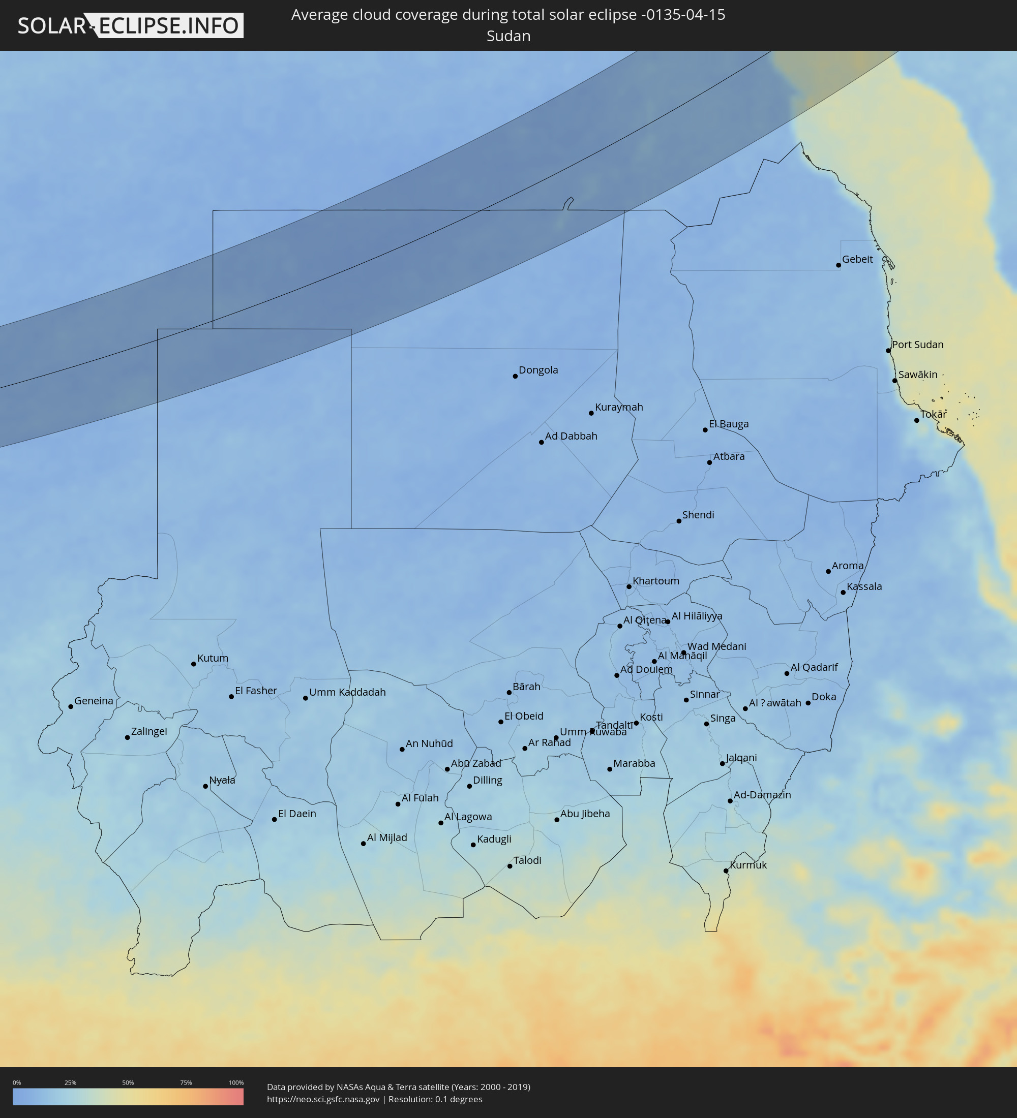 Sudan
Sudan
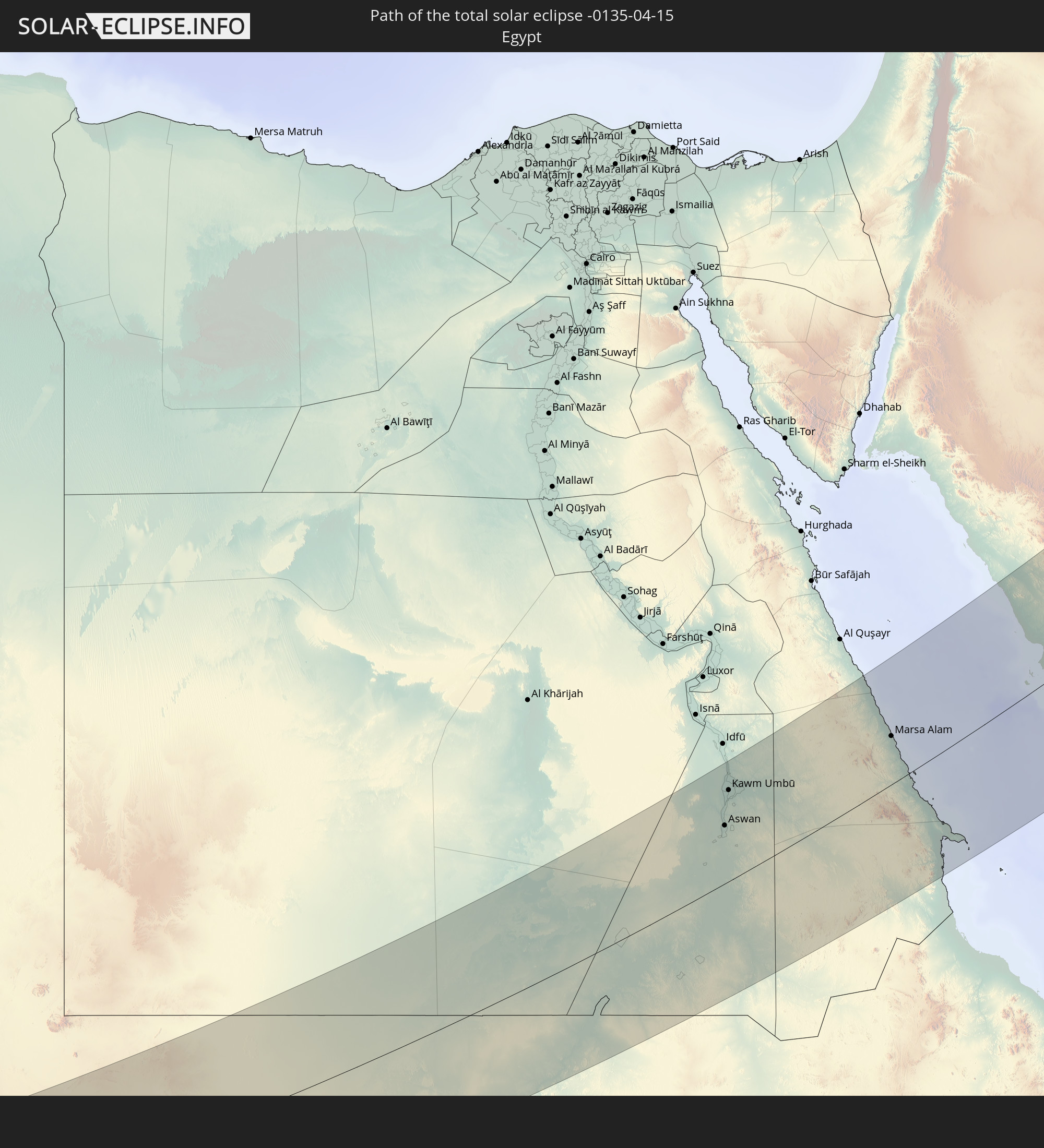
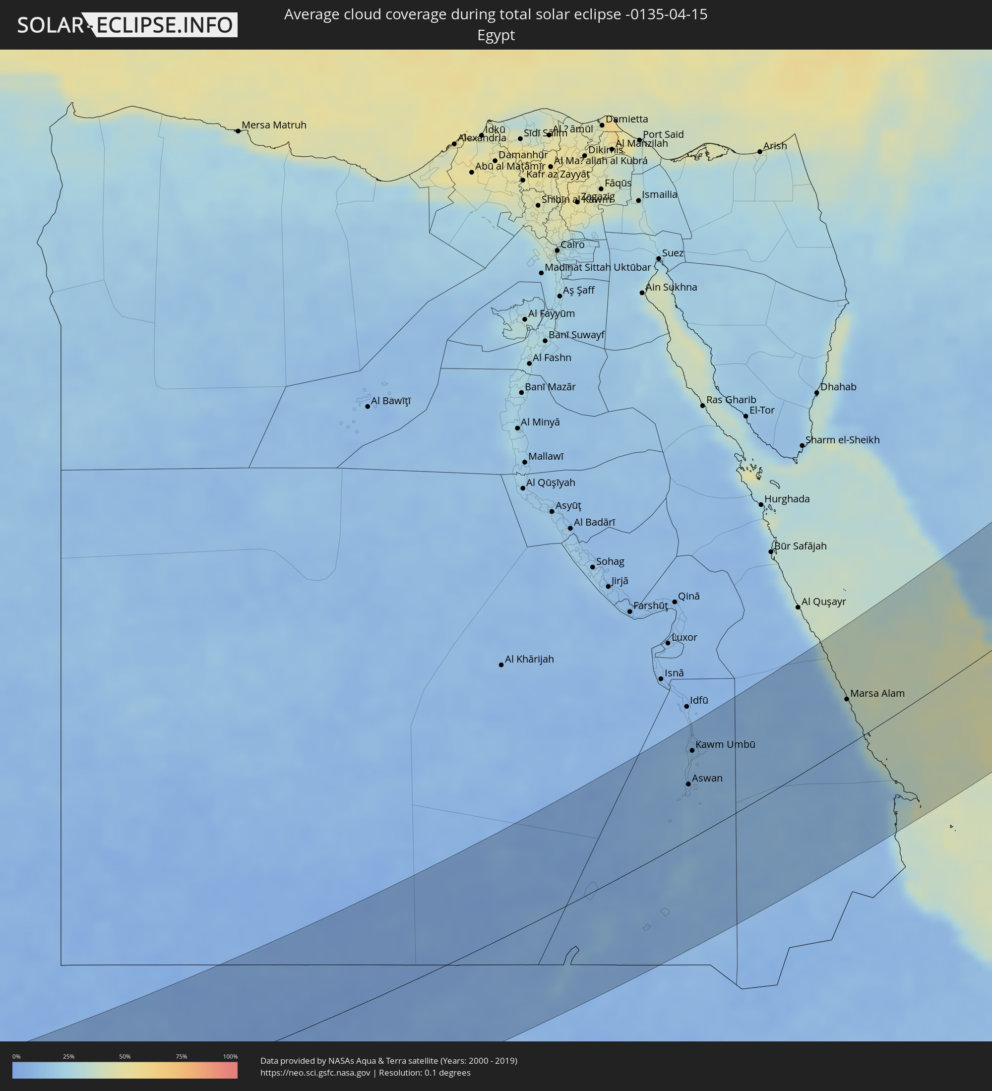 Ägypten
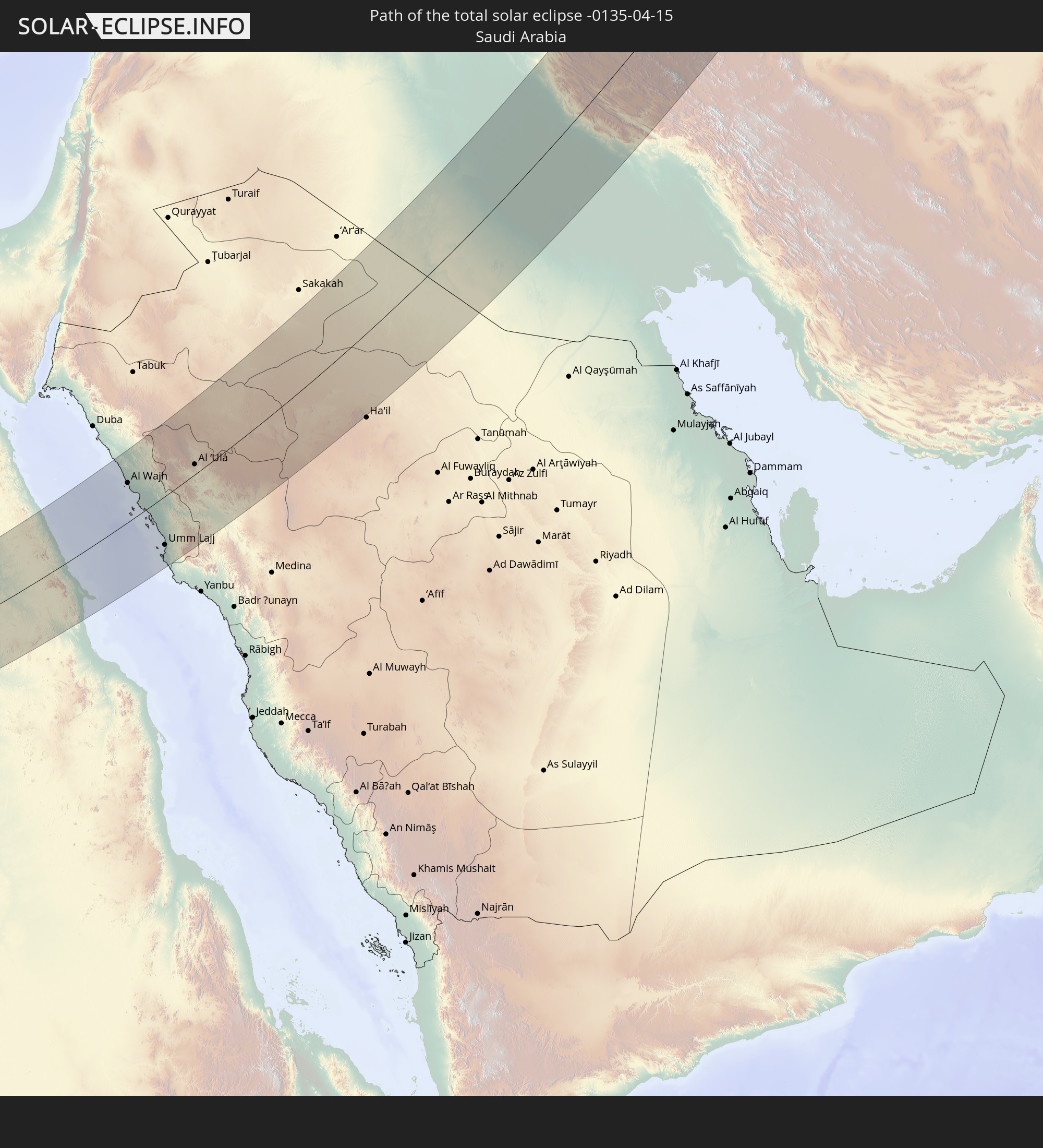
 Saudi-Arabien
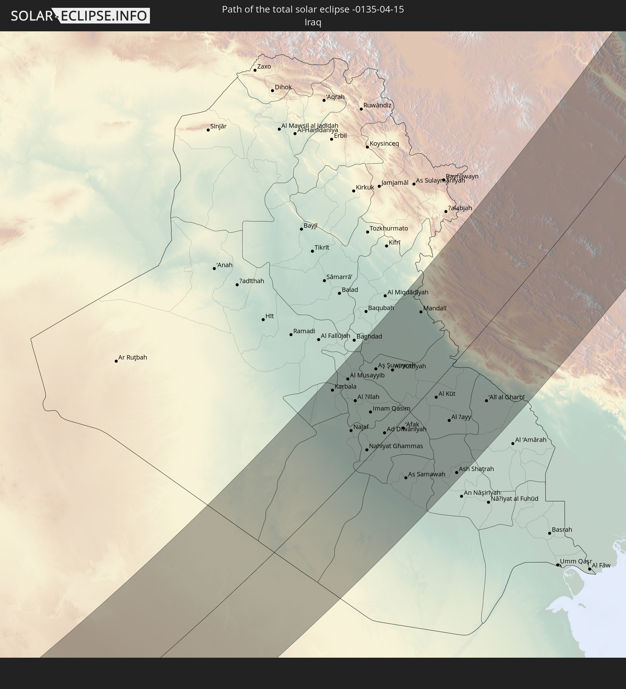
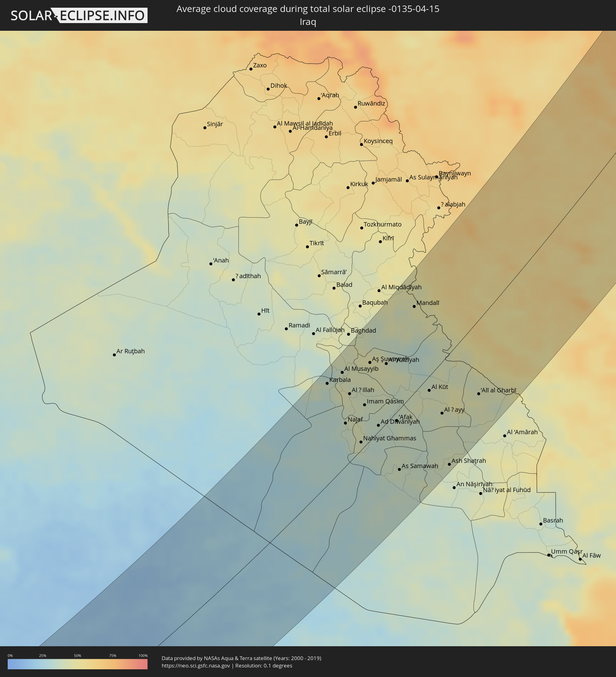 Irak
Irak
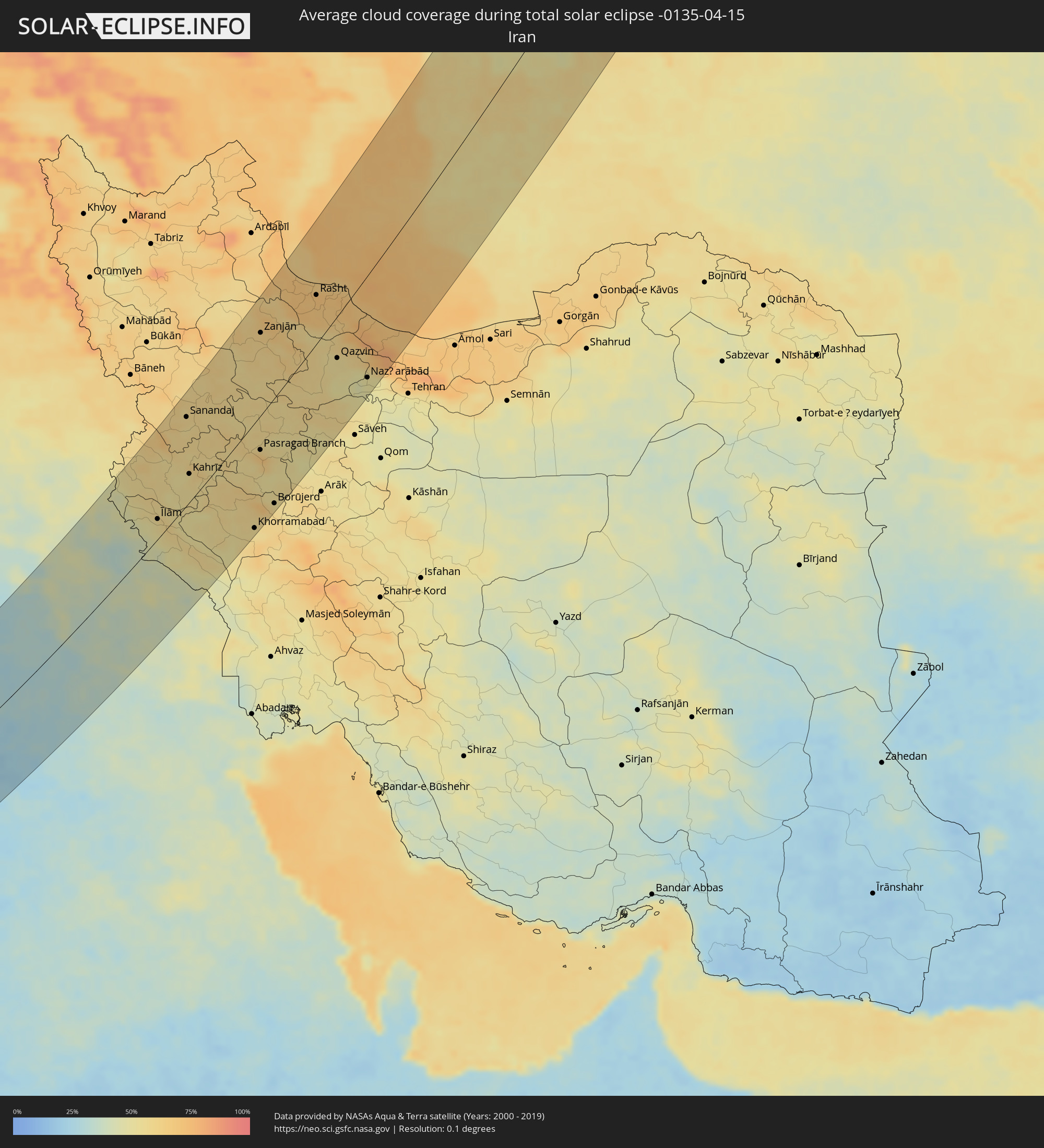 Iran
Iran
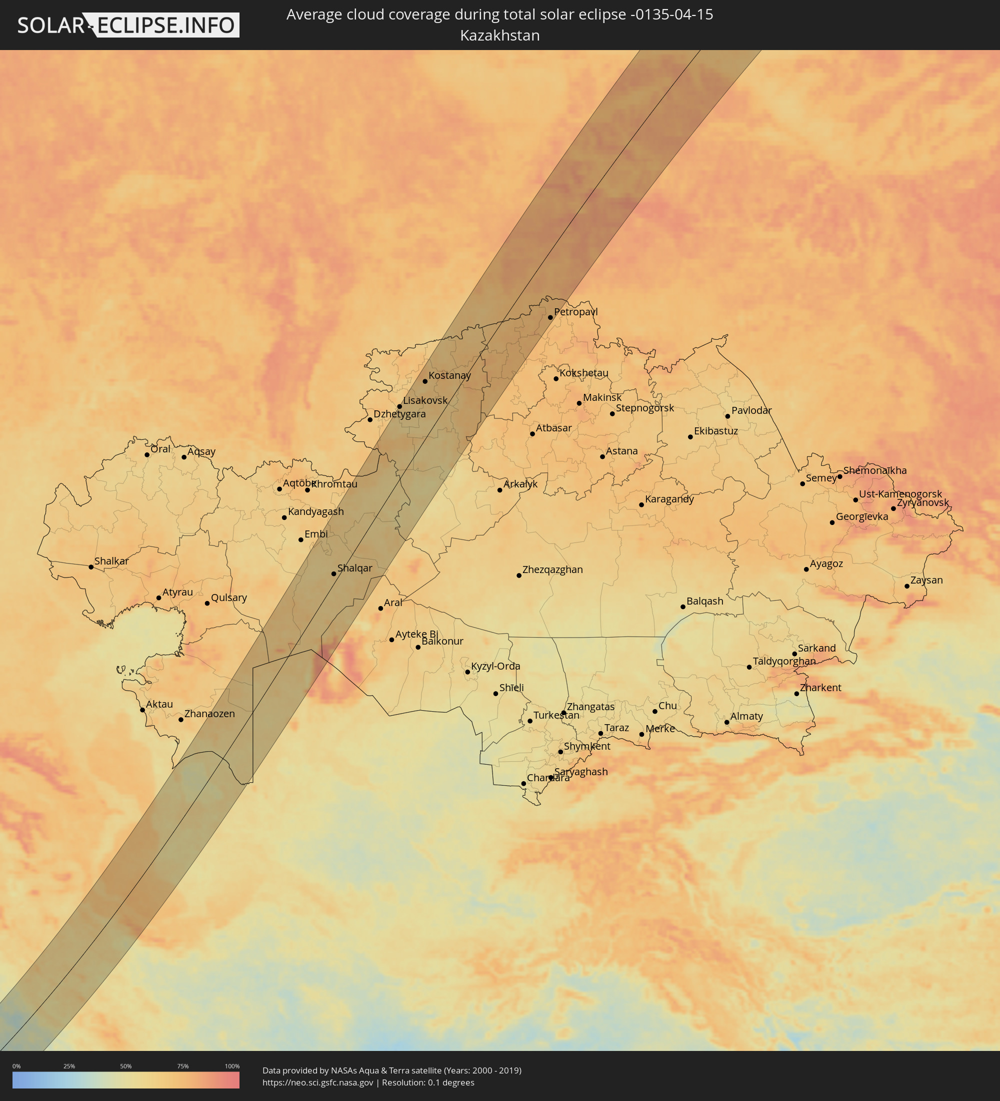 Kasachstan
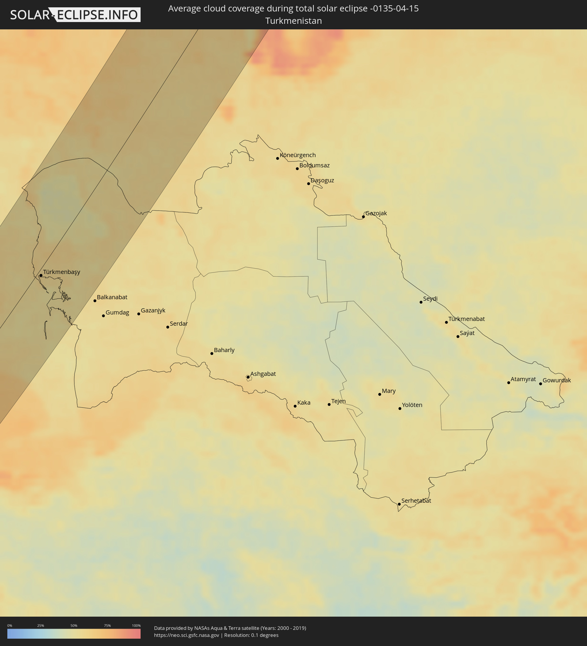 Turkmenistan
 Usbekistan
Orte im Finsternispfad
Die nachfolgene Tabelle zeigt Städte und Orte mit mehr als 5.000 Einwohnern, die sich im Finsternispfad befinden. Städte mit mehr als 100.000 Einwohnern sind dick gekennzeichnet. Mit einem Klick auf den Ort öffnet sich eine Detailkarte die die Lage des jeweiligen Ortes zusammen mit dem Verlauf der zentralen Finsternis präsentiert.
| Ort | Typ | Dauer der Verfinsterung | Ortszeit bei maximaler Verfinsterung | Entfernung zur Zentrallinie | Ø Bewölkung |
|
Faya-Largeau, Borkou
|
total | - | 05:54:19 UTC+01:00 | 61 km | 8% |
|
Aswan, Aswan
|
total | - | 07:05:27 UTC+02:00 | 61 km | 12% |
|
Kawm Umbū, Aswan
|
total | - | 07:06:07 UTC+02:00 | 96 km | 14% |
|
Marsa Alam, Red Sea
|
total | - | 07:07:52 UTC+02:00 | 49 km | 23% |
|
Al Wajh, Tabuk
|
total | - | 08:17:30 UTC+03:06 | 71 km | 28% |
|
Umm Lajj, Tabuk
|
total | - | 08:15:43 UTC+03:06 | 87 km | 26% |
|
Al ‘Ulá, Al Madīnah al Munawwarah
|
total | - | 08:18:52 UTC+03:06 | 18 km | 14% |
|
Karbala, Karbalāʼ
|
total | - | 08:24:37 UTC+02:57 | 116 km | 34% |
|
Al Hindīyah, Karbalāʼ
|
total | - | 08:24:38 UTC+02:57 | 97 km | 38% |
|
Nāḩīyat Saddat al Hindīyah, Bābil
|
total | - | 08:25:00 UTC+02:57 | 106 km | 42% |
|
Al Musayyib, Bābil
|
total | - | 08:25:08 UTC+02:57 | 110 km | 41% |
|
Najaf, An Najaf
|
total | - | 08:23:43 UTC+02:57 | 49 km | 37% |
|
Al Ḩillah, Bābil
|
total | - | 08:24:37 UTC+02:57 | 77 km | 41% |
|
Kufa, An Najaf
|
total | - | 08:23:50 UTC+02:57 | 45 km | 40% |
|
Al Mishkhāb, An Najaf
|
total | - | 08:23:24 UTC+02:57 | 23 km | 42% |
|
Ash Shāmīyah, Al Qādisīyah
|
total | - | 08:23:47 UTC+02:57 | 27 km | 41% |
|
Nahiyat Ghammas, Al Qādisīyah
|
total | - | 08:23:22 UTC+02:57 | 9 km | 37% |
|
Nāḩiyat ash Shināfīyah, Al Qādisīyah
|
total | - | 08:23:05 UTC+02:57 | 5 km | 33% |
|
Imam Qasim, Bābil
|
total | - | 08:24:29 UTC+02:57 | 47 km | 37% |
|
Aş Şuwayrah, Wāsiţ
|
total | - | 08:25:46 UTC+02:57 | 87 km | 42% |
|
Ad Dīwānīyah, Al Qādisīyah
|
total | - | 08:24:05 UTC+02:57 | 7 km | 35% |
|
Al ‘Azīzīyah, Wāsiţ
|
total | - | 08:25:57 UTC+02:57 | 66 km | 44% |
|
Ar Rumaythah, Al Muthanná
|
total | - | 08:23:23 UTC+02:57 | 48 km | 38% |
|
‘Afak, Al Qādisīyah
|
total | - | 08:24:27 UTC+02:57 | 10 km | 38% |
|
As Samawah, Al Muthanná
|
total | - | 08:23:05 UTC+02:57 | 69 km | 36% |
|
Mandalī, Diyālá
|
total | - | 08:27:57 UTC+02:57 | 93 km | 45% |
|
Al Kūt, Wāsiţ
|
total | - | 08:25:46 UTC+02:57 | 16 km | 41% |
|
Al Ḩayy, Wāsiţ
|
total | - | 08:25:16 UTC+02:57 | 57 km | 41% |
|
Ash Shaţrah, Dhi Qar
|
total | - | 08:23:53 UTC+02:57 | 124 km | 41% |
|
Īlām, Īlām
|
total | - | 08:56:33 UTC+03:25 | 25 km | 54% |
|
‘Alī al Gharbī, Maysan
|
total | - | 08:26:20 UTC+02:57 | 80 km | 45% |
|
Kāmyārān, Kordestān
|
total | - | 08:59:13 UTC+03:25 | 71 km | 56% |
|
Sanandaj, Kordestān
|
total | - | 09:00:17 UTC+03:25 | 103 km | 58% |
|
Kahrīz, Kermānshāh
|
total | - | 08:58:31 UTC+03:25 | 34 km | 59% |
|
Harsīn, Kermānshāh
|
total | - | 08:58:43 UTC+03:25 | 12 km | 59% |
|
Kūhdasht, Lorestān
|
total | - | 08:57:18 UTC+03:25 | 67 km | 55% |
|
Qorveh, Kordestān
|
total | - | 09:00:39 UTC+03:25 | 36 km | 57% |
|
Nūrābād, Lorestān
|
total | - | 08:58:39 UTC+03:25 | 53 km | 60% |
|
Asadābād, Hamadān
|
total | - | 09:00:10 UTC+03:25 | 14 km | 60% |
|
Khorramabad, Lorestān
|
total | - | 08:57:49 UTC+03:25 | 123 km | 56% |
|
Nahāvand, Hamadān
|
total | - | 08:59:13 UTC+03:25 | 73 km | 54% |
|
Pasragad Branch, Hamadān
|
total | - | 09:00:27 UTC+03:25 | 39 km | 62% |
|
Zanjān, Zanjan
|
total | - | 09:04:10 UTC+03:25 | 91 km | 63% |
|
Borūjerd, Lorestān
|
total | - | 08:58:57 UTC+03:25 | 121 km | 56% |
|
Malāyer, Hamadān
|
total | - | 08:59:48 UTC+03:25 | 98 km | 55% |
|
Alvand, Zanjan
|
total | - | 09:04:04 UTC+03:25 | 18 km | 60% |
|
Abhar, Zanjan
|
total | - | 09:03:46 UTC+03:25 | 3 km | 61% |
|
Bandar-e Anzalī, Gīlān
|
total | - | 09:06:35 UTC+03:25 | 75 km | 66% |
|
Rasht, Gīlān
|
total | - | 09:06:18 UTC+03:25 | 52 km | 71% |
|
Tākestān, Qazvīn
|
total | - | 09:04:02 UTC+03:25 | 37 km | 56% |
|
Qazvin, Qazvīn
|
total | - | 09:04:42 UTC+03:25 | 45 km | 54% |
|
Langarūd, Gīlān
|
total | - | 09:06:39 UTC+03:25 | 7 km | 70% |
|
Ābyek, Markazi
|
total | - | 09:04:47 UTC+03:25 | 98 km | 52% |
|
Naz̧arābād, Alborz
|
total | - | 09:04:37 UTC+03:25 | 109 km | 51% |
|
Chālūs, Māzandarān
|
total | - | 09:06:44 UTC+03:25 | 120 km | 68% |
|
Türkmenbaşy, Balkan
|
total | - | 09:42:32 UTC+03:53 | 9 km | 57% |
|
Shalqar, Aqtöbe
|
total | - | 09:35:28 UTC+03:25 | 15 km | 63% |
|
Svetlyy, Orenburg
|
total | - | 10:18:53 UTC+04:02 | 112 km | 66% |
|
Lisakovsk, Qostanay
|
total | - | 10:42:34 UTC+04:21 | 115 km | 63% |
|
Rudnyy, Qostanay
|
total | - | 10:43:50 UTC+04:21 | 105 km | 64% |
|
Torghay, Qostanay
|
total | - | 10:38:59 UTC+04:21 | 118 km | 60% |
|
Kostanay, Qostanay
|
total | - | 10:44:41 UTC+04:21 | 90 km | 63% |
|
Borovskoy, Qostanay
|
total | - | 10:46:06 UTC+04:21 | 93 km | 67% |
|
Qusmuryn, Qostanay
|
total | - | 10:44:33 UTC+04:21 | 12 km | 64% |
|
Vargashi, Kurgan
|
total | - | 10:30:37 UTC+04:02 | 97 km | 69% |
|
Lebyazh’ye, Kurgan
|
total | - | 10:31:08 UTC+04:02 | 57 km | 67% |
|
Novoishimskiy, Soltüstik Qazaqstan
|
total | - | 10:47:50 UTC+04:21 | 86 km | 72% |
|
Makushino, Kurgan
|
total | - | 10:31:47 UTC+04:02 | 14 km | 74% |
|
Sergeyevka, Soltüstik Qazaqstan
|
total | - | 10:49:27 UTC+04:21 | 78 km | 75% |
|
Omutinskiy, Tyumenskaya
|
total | - | 10:33:51 UTC+04:02 | 70 km | 77% |
|
Petukhovo, Kurgan
|
total | - | 10:32:14 UTC+04:02 | 30 km | 73% |
|
Golyshmanovo, Tyumenskaya
|
total | - | 10:34:26 UTC+04:02 | 30 km | 78% |
|
Bishkul, Soltüstik Qazaqstan
|
total | - | 10:52:22 UTC+04:21 | 111 km | 73% |
|
Petropavl, Soltüstik Qazaqstan
|
total | - | 10:52:32 UTC+04:21 | 108 km | 72% |
|
Kazanskoye, Tyumenskaya
|
total | - | 10:34:19 UTC+04:02 | 62 km | 74% |
|
Ishim, Tyumenskaya
|
total | - | 10:35:10 UTC+04:02 | 45 km | 77% |
|
Abatskoye, Tyumenskaya
|
total | - | 10:36:20 UTC+04:02 | 83 km | 80% |
|
Vikulovo, Tyumenskaya
|
total | - | 10:37:07 UTC+04:02 | 56 km | 84% |
|
Tevriz, Omsk
|
total | - | 11:30:37 UTC+04:53 | 97 km | 84% |
|
Pyt-Yakh, Khanty-Mansiyskiy Avtonomnyy Okrug
|
total | - | 10:43:29 UTC+04:02 | 98 km | 81% |
|
Barsovo, Khanty-Mansiyskiy Avtonomnyy Okrug
|
total | - | 10:44:09 UTC+04:02 | 113 km | 71% |
|
Poykovskiy, Khanty-Mansiyskiy Avtonomnyy Okrug
|
total | - | 10:44:22 UTC+04:02 | 110 km | 71% |
|
Surgut, Khanty-Mansiyskiy Avtonomnyy Okrug
|
total | - | 10:44:27 UTC+04:02 | 107 km | 76% |
|
Langepas, Khanty-Mansiyskiy Avtonomnyy Okrug
|
total | - | 10:46:01 UTC+04:02 | 32 km | 71% |
|
Pokachi, Khanty-Mansiyskiy Avtonomnyy Okrug
|
total | - | 10:46:34 UTC+04:02 | 57 km | 73% |
|
Megion, Khanty-Mansiyskiy Avtonomnyy Okrug
|
total | - | 10:46:37 UTC+04:02 | 22 km | 69% |
|
Nizhnevartovsk, Khanty-Mansiyskiy Avtonomnyy Okrug
|
total | - | 10:46:56 UTC+04:02 | 47 km | 69% |
|
Novoagansk, Khanty-Mansiyskiy Avtonomnyy Okrug
|
total | - | 10:47:52 UTC+04:02 | 20 km | 67% |
|
Izluchinsk, Khanty-Mansiyskiy Avtonomnyy Okrug
|
total | - | 10:47:18 UTC+04:02 | 59 km | 69% |
|
Raduzhny, Khanty-Mansiyskiy Avtonomnyy Okrug
|
total | - | 10:48:41 UTC+04:02 | 2 km | 67% |
|
Strezhevoy, Tomsk
|
total | - | 12:56:34 UTC+06:11 | 105 km | 69% |
|
Igarka, Krasnoyarskiy
|
total | - | 13:07:33 UTC+06:11 | 85 km | 67% |