Totale Sonnenfinsternis vom 24.03.-0171
| Wochentag: | Sonntag |
| Maximale Dauer der Verfinsterung: | 02m45s |
| Maximale Breite des Finsternispfades: | 235 km |
| Saroszyklus: | 75 |
| Bedeckungsgrad: | 100% |
| Magnitude: | 1.0394 |
| Gamma: | 0.8357 |
Wo kann man die Sonnenfinsternis vom 24.03.-0171 sehen?
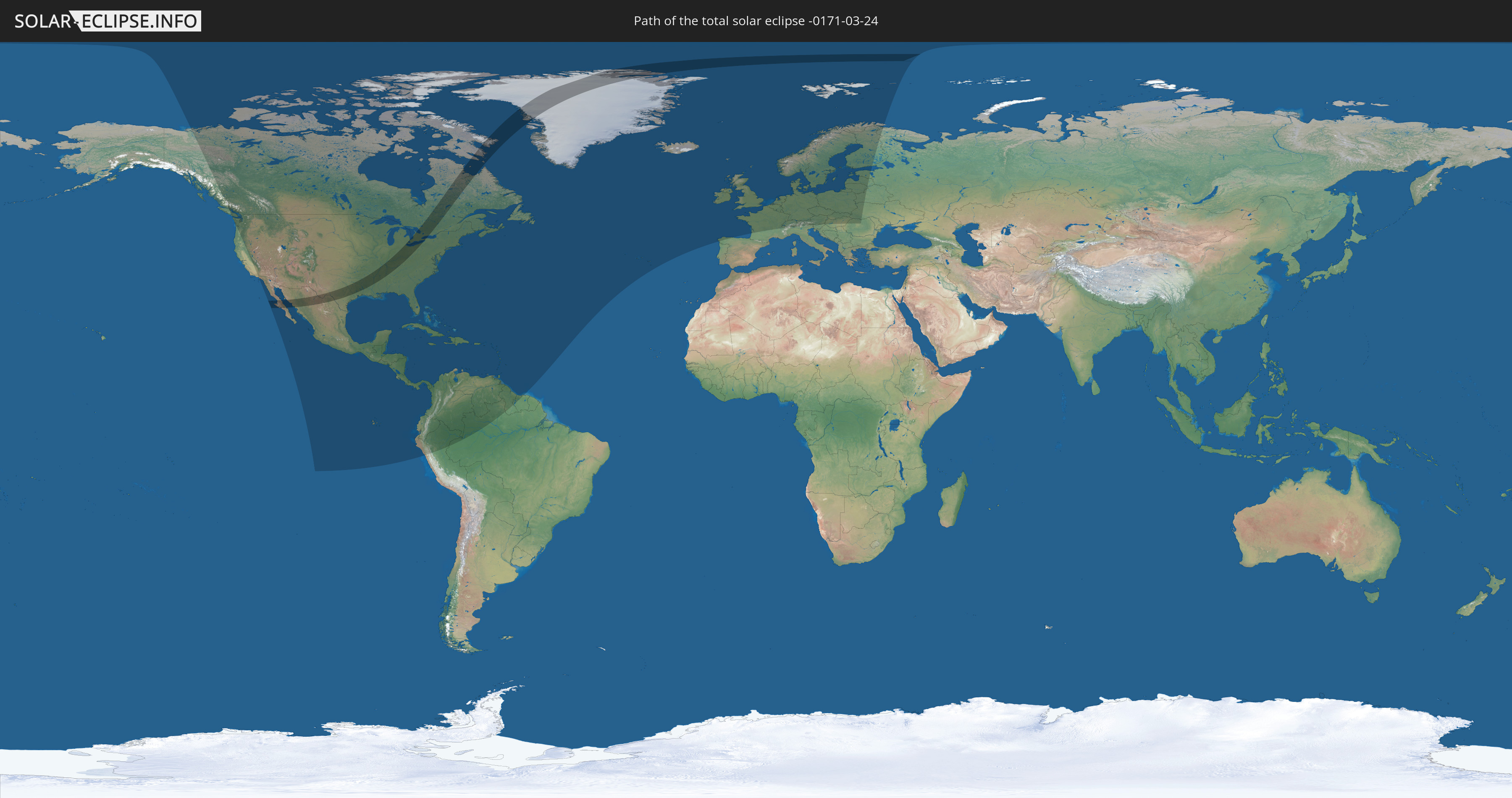
Die Sonnenfinsternis am 24.03.-0171 kann man in 82 Ländern als partielle Sonnenfinsternis beobachten.
Der Finsternispfad verläuft durch 4 Länder. Nur in diesen Ländern ist sie als totale Sonnenfinsternis zu sehen.
In den folgenden Ländern ist die Sonnenfinsternis total zu sehen
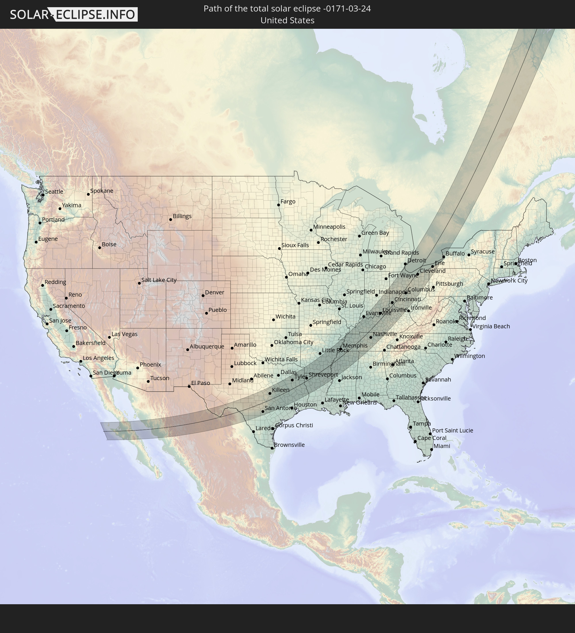 Vereinigte Staaten
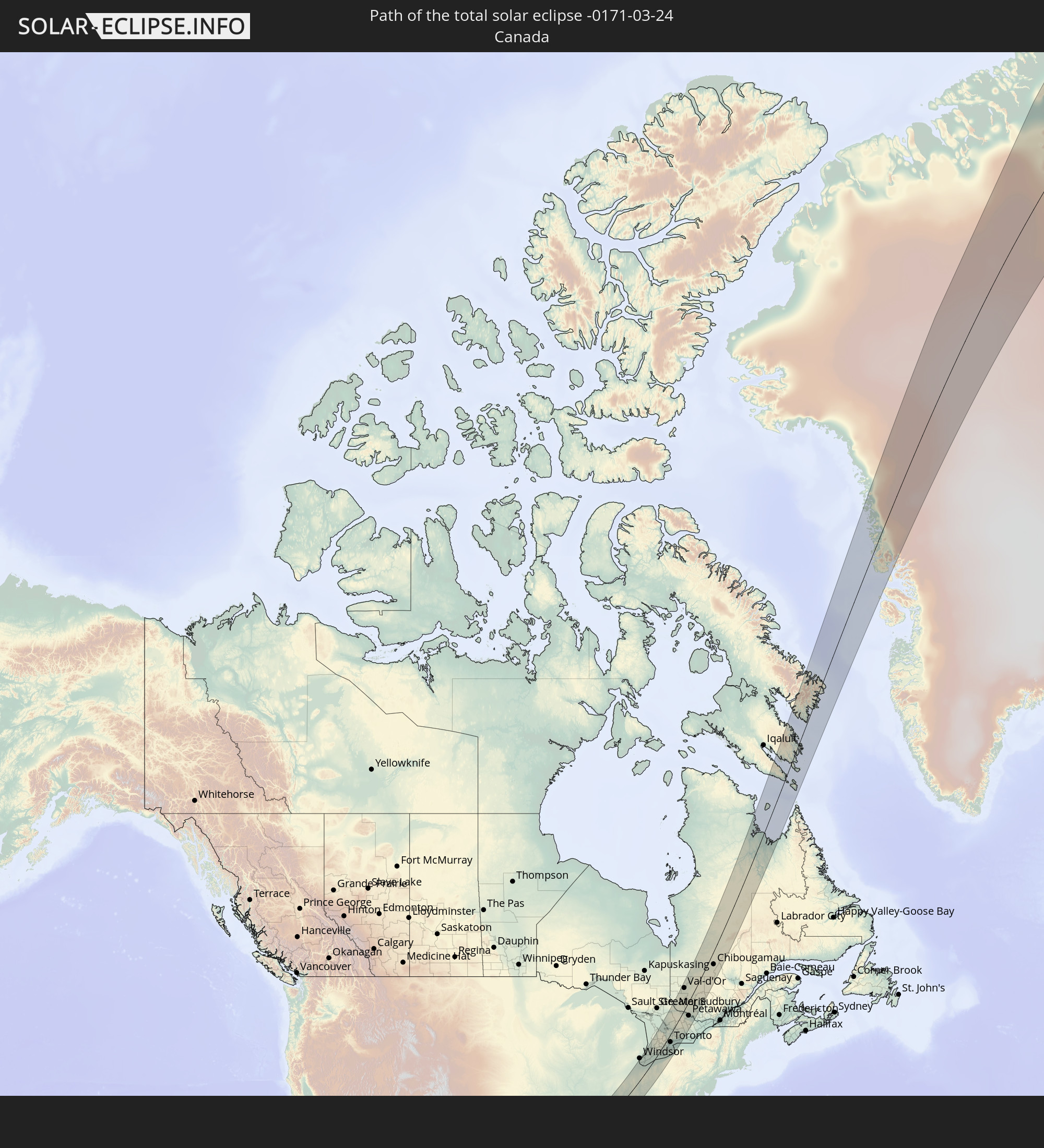 Kanada
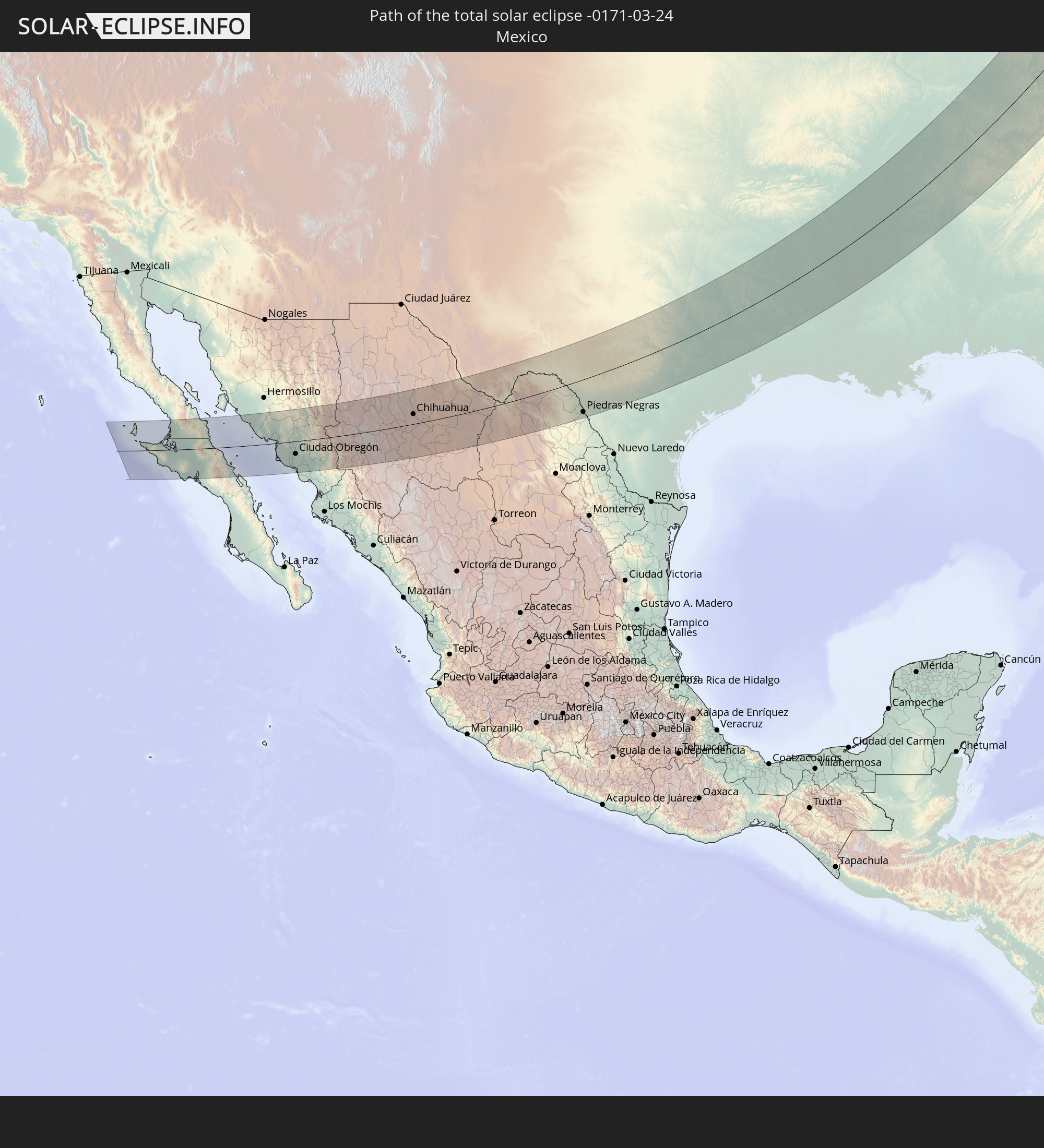 Mexiko
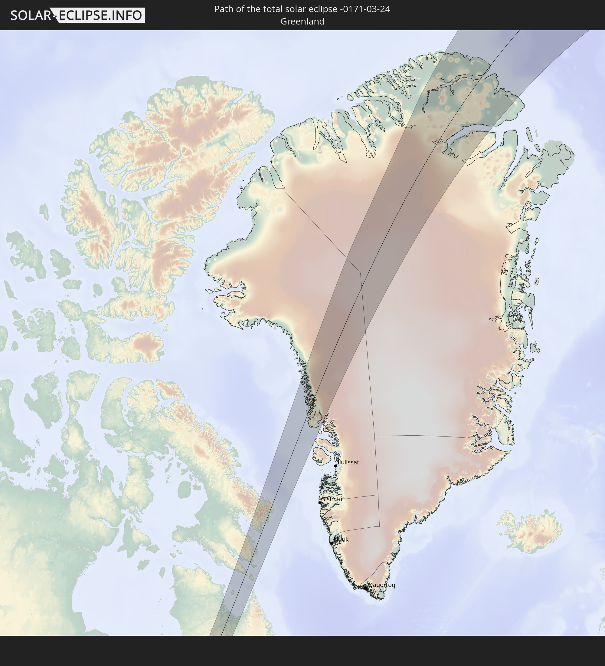 Grönland
In den folgenden Ländern ist die Sonnenfinsternis partiell zu sehen
 Russland
 Vereinigte Staaten
 United States Minor Outlying Islands
 Kanada
 Mexiko
 Grönland
 Guatemala
 Ecuador
 El Salvador
 Honduras
 Belize
 Nicaragua
 Costa Rica
 Kuba
Kuba
 Panama
 Kolumbien
 Kaimaninseln
 Peru
Peru
 Bahamas
 Jamaika
 Haiti
Haiti
 Brasilien
 Venezuela
 Turks- und Caicosinseln
 Dominikanische Republik
 Aruba
Aruba
 Puerto Rico
 Amerikanische Jungferninseln
 Bermuda
 Britische Jungferninseln
 Anguilla
 Saint-Martin
 Saint-Barthélemy
 St. Kitts und Nevis
 Antigua und Barbuda
 Montserrat
 Trinidad und Tobago
 Guadeloupe
 Grenada
 Dominica
 St. Vincent und die Grenadinen
 Guyana
 Martinique
 St. Lucia
 Barbados
 Suriname
 Saint-Pierre und Miquelon
 Portugal
 Island
 Spanien
 Irland
 Spitzbergen
 Vereinigtes Königreich
 Färöer
 Frankreich
 Isle of Man
 Guernsey
 Jersey
 Belgien
 Niederlande
 Norwegen
 Luxemburg
 Deutschland
 Schweiz
 Italien
 Dänemark
 Liechtenstein
 Österreich
 Schweden
 Tschechien
 Slowenien
 Polen
Polen
 Ungarn
 Slowakei
 Åland Islands
 Rumänien
 Finnland
 Litauen
 Lettland
 Estland
 Ukraine
 Weißrussland
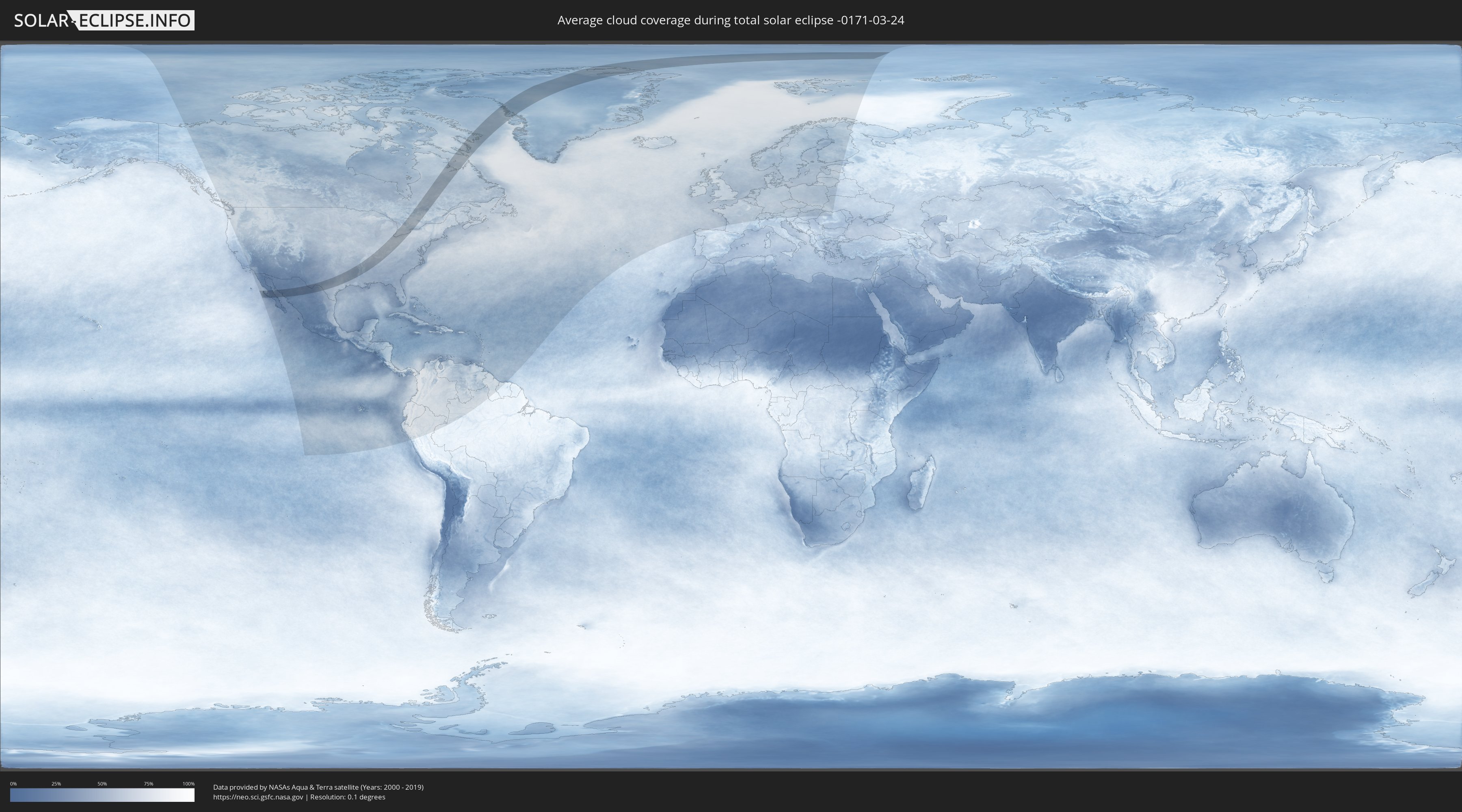
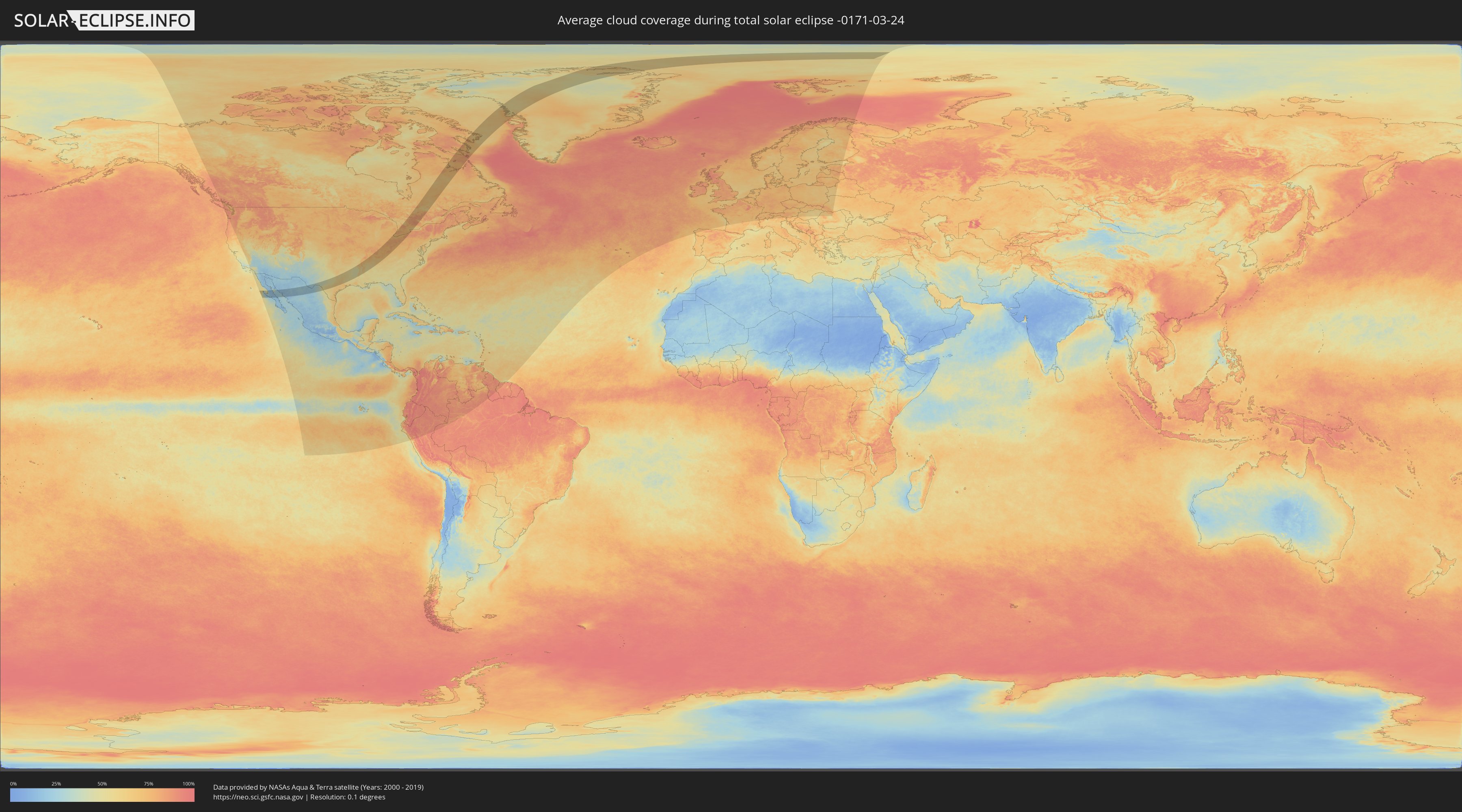
Wie wird das Wetter während der totalen Sonnenfinsternis am 24.03.-0171?
Wo ist der beste Ort, um die totale Sonnenfinsternis vom 24.03.-0171 zu beobachten?
Die folgenden Karten zeigen die durchschnittliche Bewölkung für den Tag, an dem die totale Sonnenfinsternis
stattfindet. Mit Hilfe der Karten lässt sich der Ort entlang des Finsternispfades eingrenzen,
der die besten Aussichen auf einen klaren wolkenfreien Himmel bietet.
Trotzdem muss man immer lokale Gegenenheiten beachten und sollte sich genau über das Wetter an seinem
gewählten Beobachtungsort informieren.
Die Daten stammen von den beiden NASA-Satelliten
AQUA und TERRA
und wurden über einen Zeitraum von 19 Jahren (2000 - 2019) gemittelt.
Detaillierte Länderkarten
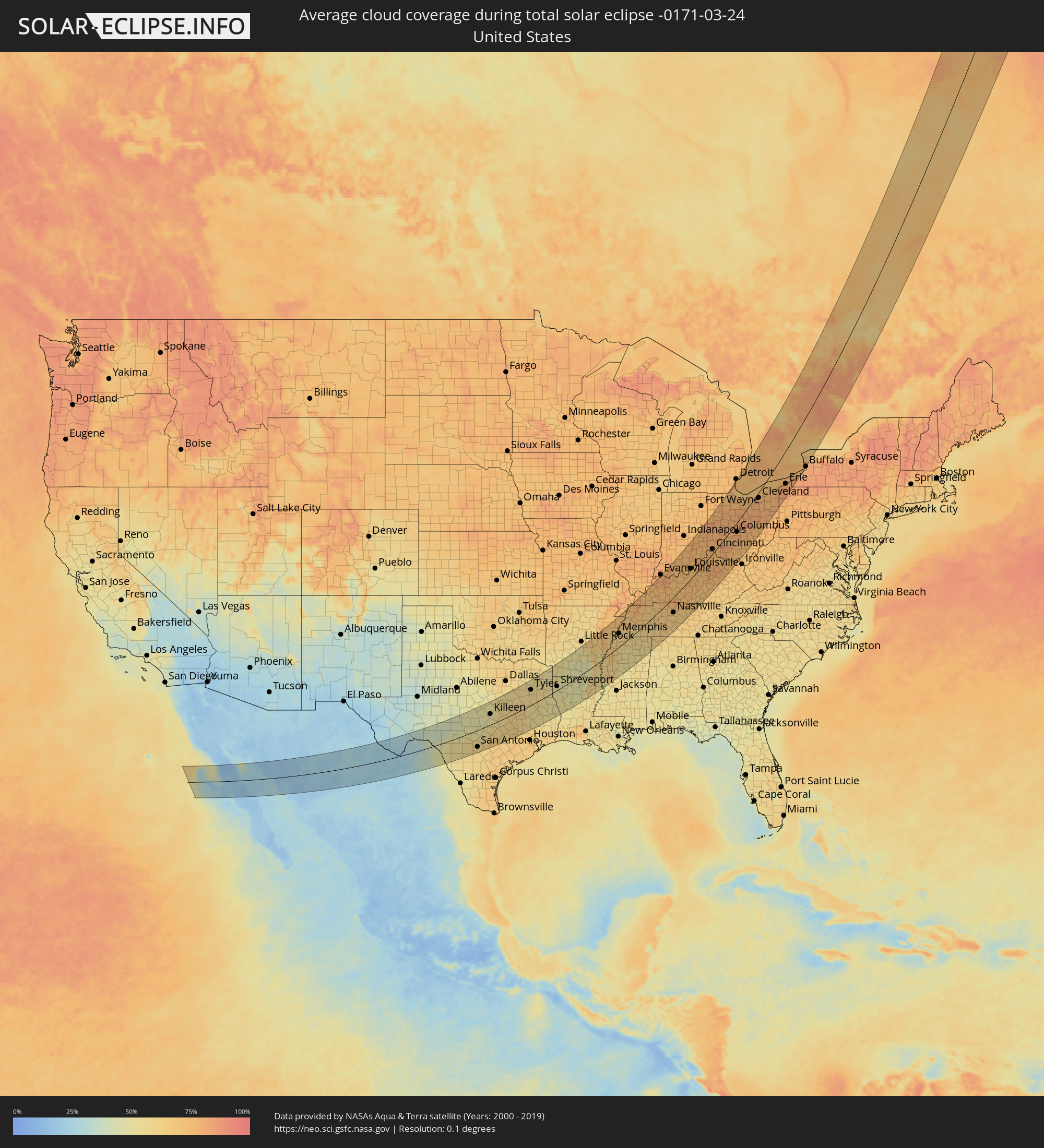 Vereinigte Staaten
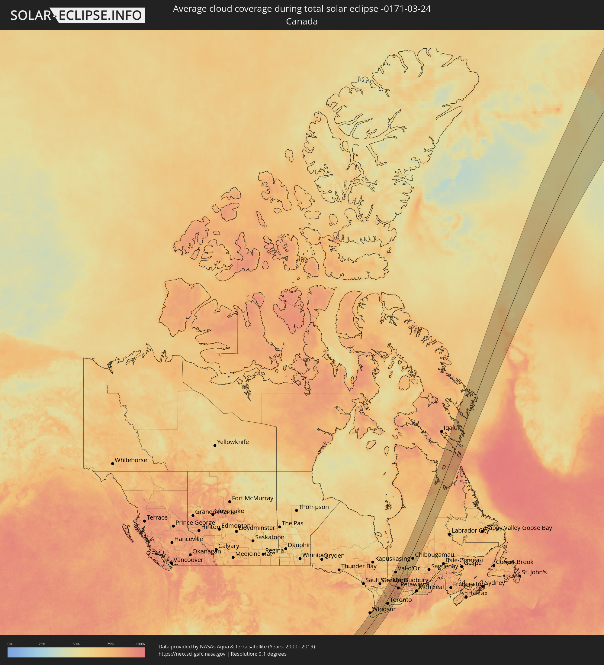 Kanada
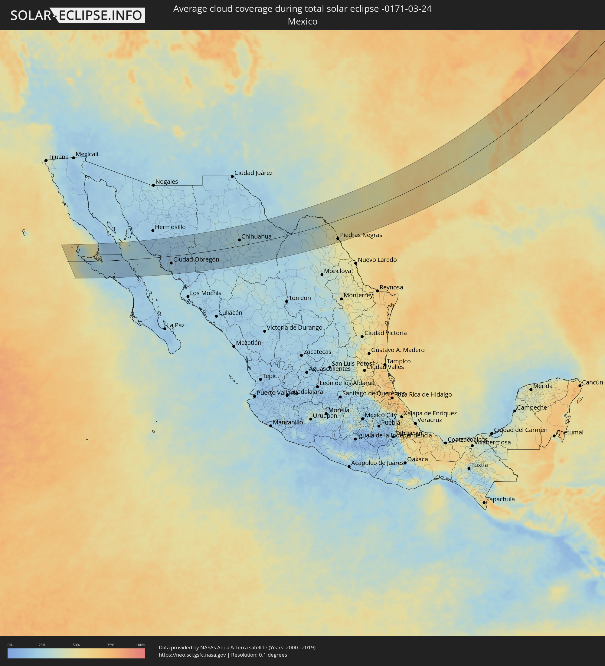 Mexiko
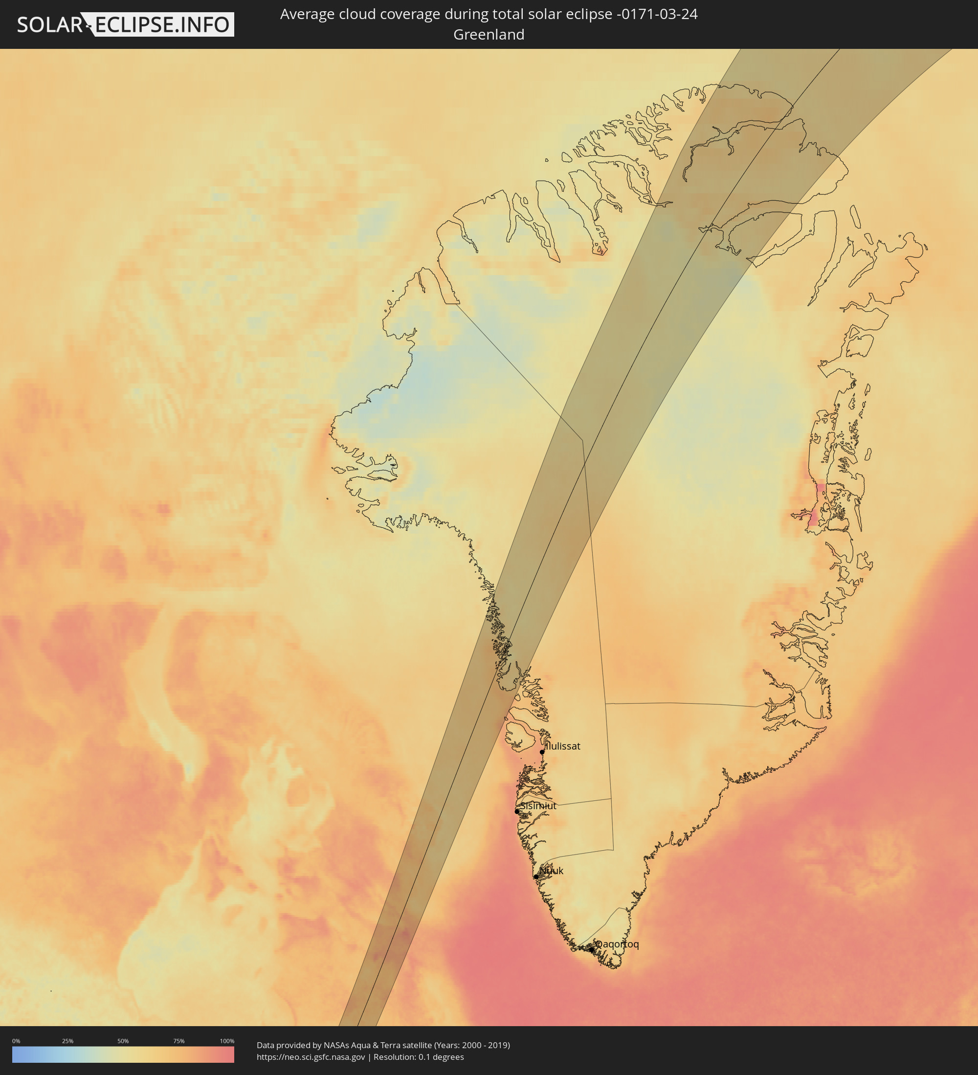 Grönland
Orte im Finsternispfad
Die nachfolgene Tabelle zeigt Städte und Orte mit mehr als 5.000 Einwohnern, die sich im Finsternispfad befinden. Städte mit mehr als 100.000 Einwohnern sind dick gekennzeichnet. Mit einem Klick auf den Ort öffnet sich eine Detailkarte die die Lage des jeweiligen Ortes zusammen mit dem Verlauf der zentralen Finsternis präsentiert.
| Ort | Typ | Dauer der Verfinsterung | Ortszeit bei maximaler Verfinsterung | Entfernung zur Zentrallinie | Ø Bewölkung |
|
San Luis, Baja California
|
total | - | 06:04:06 UTC-07:48 | 91 km | 13% |
|
Villa Alberto Andrés Alvarado Arámburo, Baja California Sur
|
total | - | 06:45:17 UTC-07:05 | 2 km | 20% |
|
Santa Rosalia, Baja California Sur
|
total | - | 06:44:53 UTC-07:05 | 38 km | 17% |
|
Heroica Guaymas, Sonora
|
total | - | 06:27:45 UTC-07:23 | 17 km | 25% |
|
Empalme, Sonora
|
total | - | 06:27:50 UTC-07:23 | 21 km | 23% |
|
Potam, Sonora
|
total | - | 06:27:21 UTC-07:23 | 20 km | 18% |
|
Vicam, Sonora
|
total | - | 06:27:23 UTC-07:23 | 20 km | 20% |
|
San Ignacio Río Muerto, Sonora
|
total | - | 06:27:02 UTC-07:23 | 45 km | 20% |
|
Campo Sesenta, Sonora
|
total | - | 06:27:06 UTC-07:23 | 43 km | 23% |
|
Pueblo Yaqui, Sonora
|
total | - | 06:26:58 UTC-07:23 | 54 km | 22% |
|
Cocorit, Sonora
|
total | - | 06:27:20 UTC-07:23 | 30 km | 21% |
|
Ciudad Obregón, Sonora
|
total | - | 06:27:11 UTC-07:23 | 40 km | 23% |
|
El Tobarito, Sonora
|
total | - | 06:27:00 UTC-07:23 | 54 km | 23% |
|
Marte R. Gómez (Tobarito), Sonora
|
total | - | 06:27:00 UTC-07:23 | 54 km | 23% |
|
Villa Juarez, Sonora
|
total | - | 06:26:38 UTC-07:23 | 81 km | 20% |
|
Bacobampo, Sonora
|
total | - | 06:26:25 UTC-07:23 | 99 km | 19% |
|
Navojoa, Sonora
|
total | - | 06:26:36 UTC-07:23 | 92 km | 18% |
|
Creel, Chihuahua
|
total | - | 06:46:14 UTC-07:05 | 40 km | 19% |
|
Adolfo López Mateos, Chihuahua
|
total | - | 06:47:29 UTC-07:05 | 33 km | 22% |
|
Cuauhtémoc, Chihuahua
|
total | - | 06:47:29 UTC-07:05 | 20 km | 24% |
|
Anáhuac, Chihuahua
|
total | - | 06:47:39 UTC-07:05 | 26 km | 26% |
|
Valentín Gómez Farías, Chihuahua
|
total | - | 06:47:14 UTC-07:05 | 6 km | 24% |
|
Chihuahua, Chihuahua
|
total | - | 06:48:04 UTC-07:05 | 31 km | 25% |
|
Ampliación Colonia Lázaro Cárdenas, Chihuahua
|
total | - | 06:47:46 UTC-07:05 | 6 km | 24% |
|
Rosales, Chihuahua
|
total | - | 06:47:27 UTC-07:05 | 28 km | 25% |
|
Naica, Chihuahua
|
total | - | 06:46:55 UTC-07:05 | 65 km | 24% |
|
Pedro Meoqui, Chihuahua
|
total | - | 06:47:38 UTC-07:05 | 19 km | 23% |
|
Ciudad Delicias, Chihuahua
|
total | - | 06:47:29 UTC-07:05 | 29 km | 25% |
|
Jiménez, Chihuahua
|
total | - | 06:47:45 UTC-07:05 | 15 km | 24% |
|
Saucillo, Chihuahua
|
total | - | 06:47:16 UTC-07:05 | 50 km | 23% |
|
Ciudad Camargo, Chihuahua
|
total | - | 06:46:43 UTC-07:05 | 91 km | 22% |
|
Ojinaga, Chihuahua
|
total | - | 06:50:06 UTC-07:05 | 101 km | 25% |
|
Manuel Ojinaga, Chihuahua
|
total | - | 06:50:08 UTC-07:05 | 98 km | 24% |
|
Ciudad Acuña, Coahuila
|
total | - | 07:20:03 UTC-06:36 | 19 km | 45% |
|
Zaragoza, Coahuila
|
total | - | 07:18:37 UTC-06:36 | 108 km | 46% |
|
Del Rio, Texas
|
total | - | 07:56:45 UTC-06:00 | 17 km | 46% |
|
Piedras Negras, Coahuila
|
total | - | 07:19:09 UTC-06:36 | 98 km | 49% |
|
San Antonio, Texas
|
total | - | 07:57:56 UTC-06:00 | 89 km | 57% |
|
New Braunfels, Texas
|
total | - | 07:58:37 UTC-06:00 | 74 km | 60% |
|
San Marcos, Texas
|
total | - | 07:59:02 UTC-06:00 | 62 km | 60% |
|
Austin, Texas
|
total | - | 07:59:50 UTC-06:00 | 30 km | 60% |
|
Killeen, Texas
|
total | - | 08:01:23 UTC-06:00 | 56 km | 52% |
|
Round Rock, Texas
|
total | - | 08:00:18 UTC-06:00 | 8 km | 57% |
|
Temple, Texas
|
total | - | 08:01:33 UTC-06:00 | 39 km | 55% |
|
Waco, Texas
|
total | - | 08:02:29 UTC-06:00 | 76 km | 57% |
|
College Station, Texas
|
total | - | 08:01:15 UTC-06:00 | 50 km | 65% |
|
Huntsville, Texas
|
total | - | 08:01:52 UTC-06:00 | 73 km | 61% |
|
Conroe, Texas
|
total | - | 08:01:10 UTC-06:00 | 118 km | 63% |
|
Tyler, Texas
|
total | - | 08:05:02 UTC-06:00 | 76 km | 57% |
|
Longview, Texas
|
total | - | 08:05:39 UTC-06:00 | 64 km | 55% |
|
Lufkin, Texas
|
total | - | 08:03:29 UTC-06:00 | 49 km | 56% |
|
Texarkana, Texas
|
total | - | 08:07:49 UTC-06:00 | 119 km | 53% |
|
Shreveport, Louisiana
|
total | - | 08:06:19 UTC-06:00 | 19 km | 53% |
|
Monroe, Louisiana
|
total | - | 08:07:23 UTC-06:00 | 64 km | 50% |
|
Pine Bluff, Arkansas
|
total | - | 08:10:44 UTC-06:00 | 86 km | 54% |
|
Memphis, Tennessee
|
total | - | 08:13:56 UTC-06:00 | 57 km | 62% |
|
Southaven, Mississippi
|
total | - | 08:13:39 UTC-06:00 | 41 km | 63% |
|
Bartlett, Tennessee
|
total | - | 08:14:10 UTC-06:00 | 51 km | 60% |
|
Collierville, Tennessee
|
total | - | 08:14:01 UTC-06:00 | 25 km | 60% |
|
Jackson, Tennessee
|
total | - | 08:15:47 UTC-06:00 | 23 km | 64% |
|
Florence, Alabama
|
total | - | 08:15:08 UTC-06:00 | 114 km | 62% |
|
Clarksville, Tennessee
|
total | - | 08:18:45 UTC-06:00 | 7 km | 69% |
|
Owensboro, Kentucky
|
total | - | 08:21:22 UTC-06:00 | 88 km | 78% |
|
Columbia, Tennessee
|
total | - | 08:17:15 UTC-06:00 | 86 km | 67% |
|
Franklin, Tennessee
|
total | - | 08:17:59 UTC-06:00 | 72 km | 66% |
|
Nashville, Tennessee
|
total | - | 08:18:31 UTC-06:00 | 58 km | 65% |
|
Hendersonville, Tennessee
|
total | - | 08:18:56 UTC-06:00 | 57 km | 65% |
|
Smyrna, Tennessee
|
total | - | 08:18:24 UTC-06:00 | 89 km | 66% |
|
Bowling Green, Kentucky
|
total | - | 08:20:25 UTC-06:00 | 15 km | 76% |
|
Murfreesboro, Tennessee
|
total | - | 08:18:14 UTC-06:00 | 108 km | 65% |
|
Columbus, Indiana
|
total | - | 09:25:10 UTC-05:00 | 115 km | 76% |
|
Louisville, Kentucky
|
total | - | 09:23:28 UTC-05:00 | 36 km | 73% |
|
Richmond, Indiana
|
total | - | 09:27:17 UTC-05:00 | 91 km | 77% |
|
Hamilton, Ohio
|
total | - | 09:26:45 UTC-05:00 | 39 km | 75% |
|
Lexington-Fayette, Kentucky
|
total | - | 09:24:14 UTC-05:00 | 65 km | 79% |
|
Cincinnati, Ohio
|
total | - | 09:26:23 UTC-05:00 | 15 km | 71% |
|
Middletown, Ohio
|
total | - | 09:27:07 UTC-05:00 | 36 km | 75% |
|
Dayton, Ohio
|
total | - | 09:27:47 UTC-05:00 | 39 km | 74% |
|
Lima, Ohio
|
total | - | 09:29:46 UTC-05:00 | 99 km | 78% |
|
Springfield, Ohio
|
total | - | 09:28:27 UTC-05:00 | 24 km | 78% |
|
Findlay, Ohio
|
total | - | 09:30:45 UTC-05:00 | 88 km | 77% |
|
Toledo, Ohio
|
total | - | 09:32:02 UTC-05:00 | 122 km | 75% |
|
Marion, Ohio
|
total | - | 09:30:22 UTC-05:00 | 23 km | 80% |
|
Dublin, Ohio
|
total | - | 09:29:26 UTC-05:00 | 11 km | 76% |
|
Delaware, Ohio
|
total | - | 09:29:52 UTC-05:00 | 1 km | 78% |
|
Amherstburg, Ontario
|
total | - | 09:33:22 UTC-05:00 | 116 km | 72% |
|
Windsor, Ontario
|
total | - | 09:33:45 UTC-05:00 | 125 km | 74% |
|
Columbus, Ohio
|
total | - | 09:29:16 UTC-05:00 | 28 km | 75% |
|
Westerville, Ohio
|
total | - | 09:29:39 UTC-05:00 | 22 km | 74% |
|
Reynoldsburg, Ohio
|
total | - | 09:29:26 UTC-05:00 | 41 km | 76% |
|
Lancaster, Ohio
|
total | - | 09:29:10 UTC-05:00 | 72 km | 75% |
|
Mansfield, Ohio
|
total | - | 09:31:16 UTC-05:00 | 8 km | 79% |
|
Sarnia, Ontario
|
total | - | 09:35:36 UTC-05:00 | 124 km | 74% |
|
Newark, Ohio
|
total | - | 09:30:01 UTC-05:00 | 62 km | 78% |
|
Lorain, Ohio
|
total | - | 09:32:55 UTC-05:00 | 14 km | 74% |
|
Camlachie, Ontario
|
total | - | 09:35:57 UTC-05:00 | 111 km | 76% |
|
Lambton Shores, Ontario
|
total | - | 09:36:24 UTC-05:00 | 103 km | 81% |
|
Strongsville, Ohio
|
total | - | 09:32:58 UTC-05:00 | 18 km | 79% |
|
Goderich, Ontario
|
total | - | 09:37:42 UTC-05:00 | 122 km | 75% |
|
Cleveland, Ohio
|
total | - | 09:33:28 UTC-05:00 | 16 km | 76% |
|
Euclid, Ohio
|
total | - | 09:33:48 UTC-05:00 | 22 km | 75% |
|
Akron, Ohio
|
total | - | 09:32:50 UTC-05:00 | 55 km | 78% |
|
South Huron, Ontario
|
total | - | 09:37:05 UTC-05:00 | 83 km | 78% |
|
Canton, Ohio
|
total | - | 09:32:25 UTC-05:00 | 83 km | 78% |
|
Mentor, Ohio
|
total | - | 09:34:07 UTC-05:00 | 30 km | 74% |
|
Huron East, Ontario
|
total | - | 09:37:51 UTC-05:00 | 86 km | 74% |
|
London, Ontario
|
total | - | 09:36:43 UTC-05:00 | 44 km | 78% |
|
St. Thomas, Ontario
|
total | - | 09:36:23 UTC-05:00 | 28 km | 78% |
|
Dorchester, Ontario
|
total | - | 09:36:53 UTC-05:00 | 32 km | 78% |
|
Aylmer, Ontario
|
total | - | 09:36:33 UTC-05:00 | 14 km | 77% |
|
North Perth, Ontario
|
total | - | 09:38:23 UTC-05:00 | 69 km | 75% |
|
Stratford, Ontario
|
total | - | 09:37:43 UTC-05:00 | 47 km | 74% |
|
Owen Sound, Ontario
|
total | - | 09:39:59 UTC-05:00 | 116 km | 80% |
|
Ingersoll, Ontario
|
total | - | 09:37:09 UTC-05:00 | 23 km | 77% |
|
Warren, Ohio
|
total | - | 09:33:48 UTC-05:00 | 93 km | 77% |
|
Woodstock, Ontario
|
total | - | 09:37:28 UTC-05:00 | 20 km | 75% |
|
Youngstown, Ohio
|
total | - | 09:33:42 UTC-05:00 | 113 km | 77% |
|
Waterloo, Ontario
|
total | - | 09:38:20 UTC-05:00 | 23 km | 76% |
|
Kitchener, Ontario
|
total | - | 09:38:15 UTC-05:00 | 21 km | 76% |
|
Paris, Ontario
|
total | - | 09:37:57 UTC-05:00 | 2 km | 73% |
|
Norfolk County, Ontario
|
total | - | 09:37:16 UTC-05:00 | 24 km | 76% |
|
Brant, Ontario
|
total | - | 09:37:52 UTC-05:00 | 8 km | 74% |
|
Cambridge, Ontario
|
total | - | 09:38:19 UTC-05:00 | 3 km | 73% |
|
Brantford, Ontario
|
total | - | 09:37:56 UTC-05:00 | 14 km | 74% |
|
Guelph, Ontario
|
total | - | 09:38:44 UTC-05:00 | 10 km | 74% |
|
Collingwood, Ontario
|
total | - | 09:40:31 UTC-05:00 | 61 km | 78% |
|
Orangeville, Ontario
|
total | - | 09:39:34 UTC-05:00 | 21 km | 77% |
|
Erie, Pennsylvania
|
total | - | 09:36:13 UTC-05:00 | 87 km | 81% |
|
Wasaga Beach, Ontario
|
total | - | 09:40:46 UTC-05:00 | 50 km | 75% |
|
Ancaster, Ontario
|
total | - | 09:38:22 UTC-05:00 | 28 km | 75% |
|
Midland, Ontario
|
total | - | 09:41:20 UTC-05:00 | 54 km | 79% |
|
Angus, Ontario
|
total | - | 09:40:32 UTC-05:00 | 29 km | 75% |
|
Milton, Ontario
|
total | - | 09:39:02 UTC-05:00 | 17 km | 73% |
|
Hamilton, Ontario
|
total | - | 09:38:34 UTC-05:00 | 35 km | 73% |
|
Burlington, Ontario
|
total | - | 09:38:50 UTC-05:00 | 28 km | 72% |
|
Oakville, Ontario
|
total | - | 09:39:06 UTC-05:00 | 35 km | 71% |
|
Barrie, Ontario
|
total | - | 09:40:54 UTC-05:00 | 19 km | 80% |
|
Mississauga, Ontario
|
total | - | 09:39:22 UTC-05:00 | 29 km | 72% |
|
Innisfil, Ontario
|
total | - | 09:40:44 UTC-05:00 | 12 km | 74% |
|
Vaughan, Ontario
|
total | - | 09:40:01 UTC-05:00 | 25 km | 69% |
|
Concord, Ontario
|
total | - | 09:39:58 UTC-05:00 | 28 km | 69% |
|
North Bay, Ontario
|
total | - | 09:44:37 UTC-05:00 | 110 km | 64% |
|
Keswick, Ontario
|
total | - | 09:40:49 UTC-05:00 | 3 km | 73% |
|
Newmarket, Ontario
|
total | - | 09:40:26 UTC-05:00 | 15 km | 72% |
|
Richmond Hill, Ontario
|
total | - | 09:40:08 UTC-05:00 | 27 km | 71% |
|
Orillia, Ontario
|
total | - | 09:41:31 UTC-05:00 | 14 km | 74% |
|
Toronto, Ontario
|
total | - | 09:39:50 UTC-05:00 | 38 km | 69% |
|
Willowdale, Ontario
|
total | - | 09:39:59 UTC-05:00 | 36 km | 69% |
|
East York, Ontario
|
total | - | 09:39:54 UTC-05:00 | 45 km | 69% |
|
Bracebridge, Ontario
|
total | - | 09:42:25 UTC-05:00 | 31 km | 79% |
|
Scarborough, Ontario
|
total | - | 09:40:08 UTC-05:00 | 45 km | 69% |
|
Welland, Ontario
|
total | - | 09:38:40 UTC-05:00 | 92 km | 75% |
|
St. Catharines, Ontario
|
total | - | 09:39:01 UTC-05:00 | 81 km | 73% |
|
Port Colborne, Ontario
|
total | - | 09:38:31 UTC-05:00 | 98 km | 73% |
|
Huntsville, Ontario
|
total | - | 09:43:04 UTC-05:00 | 40 km | 82% |
|
Thorold, Ontario
|
total | - | 09:38:58 UTC-05:00 | 88 km | 75% |
|
Pickering, Ontario
|
total | - | 09:40:29 UTC-05:00 | 46 km | 68% |
|
Uxbridge, Ontario
|
total | - | 09:40:53 UTC-05:00 | 36 km | 75% |
|
Niagara Falls, Ontario
|
total | - | 09:39:04 UTC-05:00 | 98 km | 75% |
|
Niagara Falls, New York
|
total | - | 09:39:04 UTC-05:00 | 99 km | 75% |
|
Ajax, Ontario
|
total | - | 09:40:30 UTC-05:00 | 56 km | 67% |
|
Fort Erie, Ontario
|
total | - | 09:38:49 UTC-05:00 | 119 km | 76% |
|
Tonawanda, New York
|
total | - | 09:39:02 UTC-05:00 | 118 km | 77% |
|
Oshawa, Ontario
|
total | - | 09:40:46 UTC-05:00 | 66 km | 64% |
|
Peterborough, Ontario
|
total | - | 09:42:03 UTC-05:00 | 79 km | 72% |
|
Cobourg, Ontario
|
total | - | 09:41:34 UTC-05:00 | 109 km | 61% |
|
Val-d'Or, Quebec
|
total | - | 09:49:26 UTC-05:00 | 89 km | 68% |
|
Petawawa, Ontario
|
total | - | 09:46:00 UTC-05:00 | 60 km | 72% |
|
Pembroke, Ontario
|
total | - | 09:46:01 UTC-05:00 | 76 km | 67% |
|
Chibougamau, Quebec
|
total | - | 09:55:55 UTC-05:00 | 47 km | 64% |