Total solar eclipse of 03/24/-0171
| Day of week: | Sunday |
| Maximum duration of eclipse: | 02m45s |
| Maximum width of eclipse path: | 235 km |
| Saros cycle: | 75 |
| Coverage: | 100% |
| Magnitude: | 1.0394 |
| Gamma: | 0.8357 |
Wo kann man die Sonnenfinsternis vom 03/24/-0171 sehen?
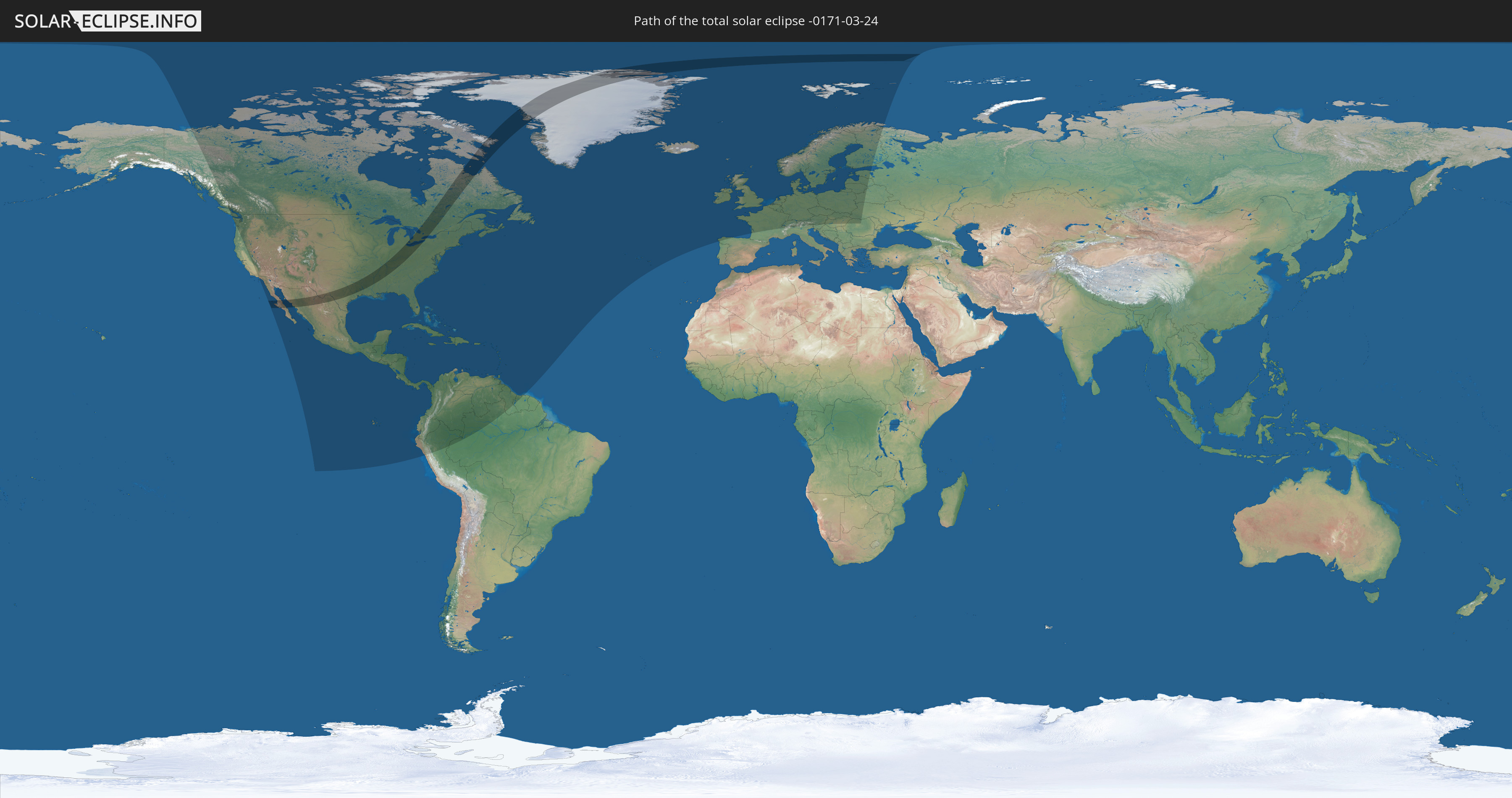
Die Sonnenfinsternis am 03/24/-0171 kann man in 82 Ländern als partielle Sonnenfinsternis beobachten.
Der Finsternispfad verläuft durch 4 Länder. Nur in diesen Ländern ist sie als total Sonnenfinsternis zu sehen.
In den folgenden Ländern ist die Sonnenfinsternis total zu sehen
 United States
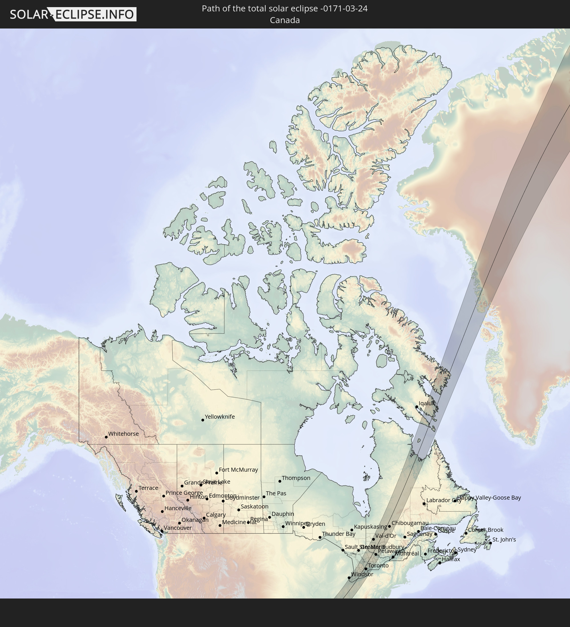 Canada
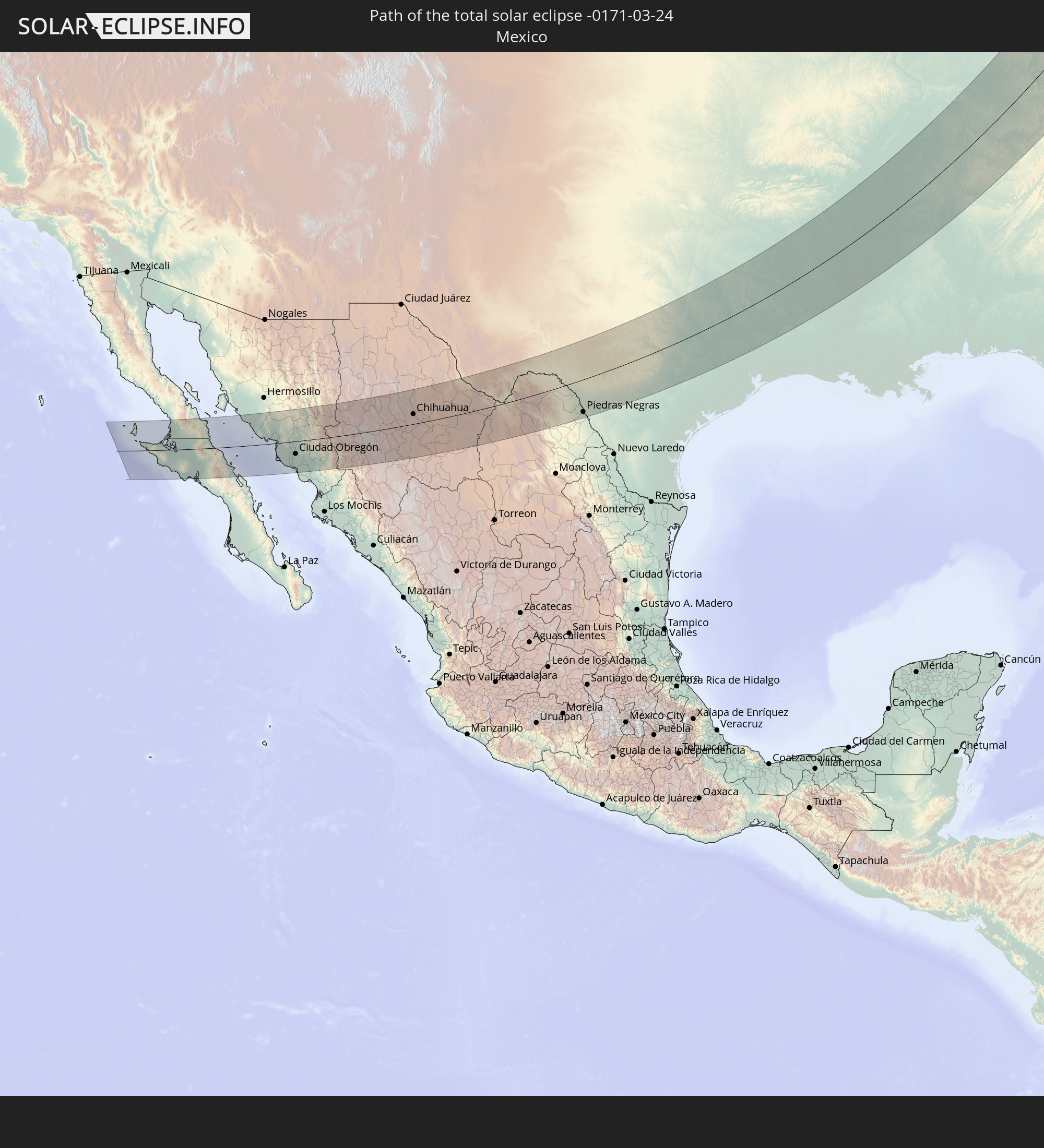 Mexico
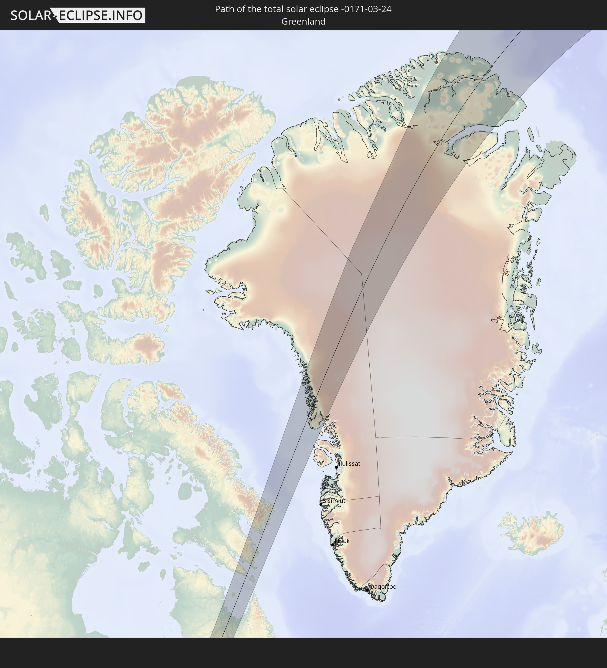 Greenland
In den folgenden Ländern ist die Sonnenfinsternis partiell zu sehen
 Russia
 United States
 United States Minor Outlying Islands
 Canada
 Mexico
 Greenland
 Guatemala
 Ecuador
 El Salvador
 Honduras
 Belize
 Nicaragua
 Costa Rica
 Cuba
Cuba
 Panama
 Colombia
 Cayman Islands
 Peru
Peru
 The Bahamas
 Jamaica
 Haiti
Haiti
 Brazil
 Venezuela
 Turks and Caicos Islands
 Dominican Republic
 Aruba
Aruba
 Puerto Rico
 United States Virgin Islands
 Bermuda
 British Virgin Islands
 Anguilla
 Collectivity of Saint Martin
 Saint Barthélemy
 Saint Kitts and Nevis
 Antigua and Barbuda
 Montserrat
 Trinidad and Tobago
 Guadeloupe
 Grenada
 Dominica
 Saint Vincent and the Grenadines
 Guyana
 Martinique
 Saint Lucia
 Barbados
 Suriname
 Saint Pierre and Miquelon
 Portugal
 Iceland
 Spain
Spain
 Republic of Ireland
 Svalbard and Jan Mayen
 United Kingdom
 Faroe Islands
 France
 Isle of Man
 Guernsey
 Jersey
 Belgium
 Netherlands
 Norway
 Luxembourg
 Germany
 Switzerland
 Italy
Italy
 Denmark
 Liechtenstein
 Austria
 Sweden
 Czechia
 Slovenia
 Poland
 Hungary
 Slovakia
 Åland Islands
 Romania
 Finland
 Lithuania
 Latvia
 Estonia
 Ukraine
 Belarus
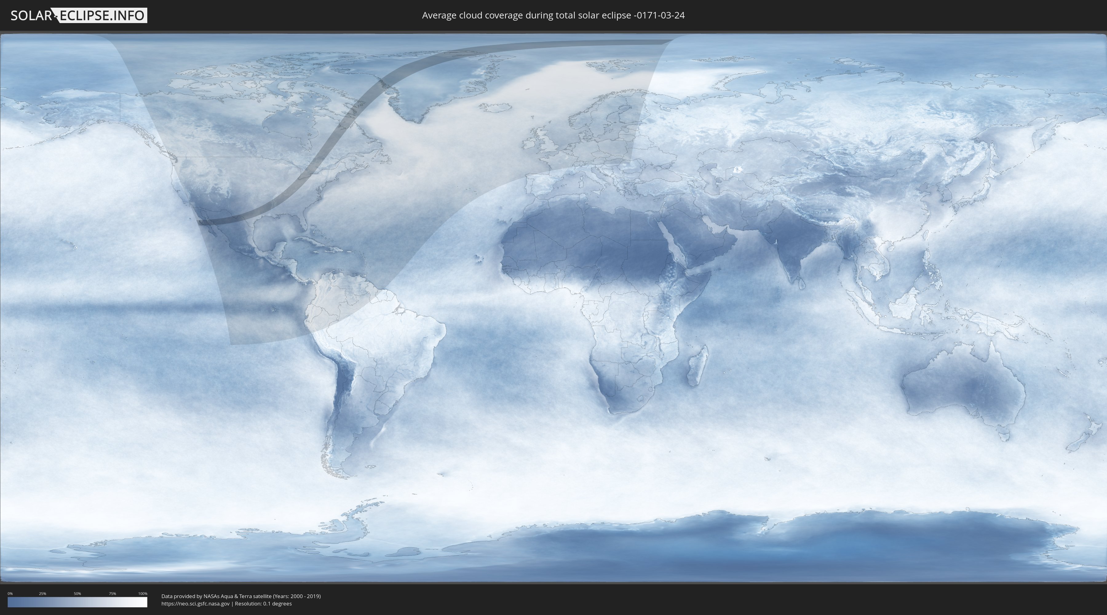
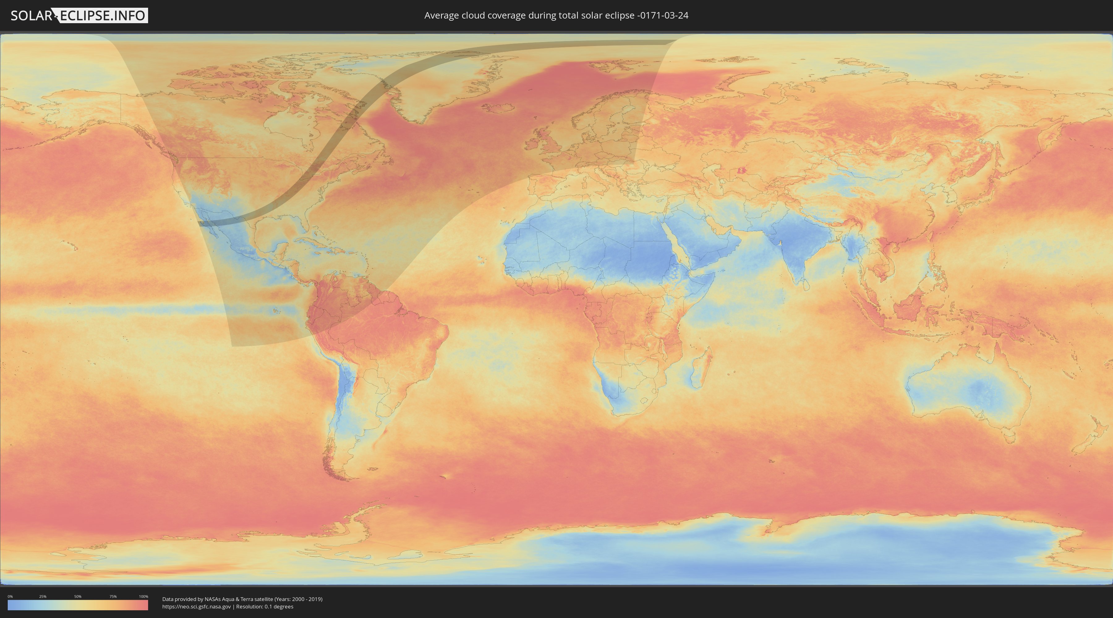
How will be the weather during the total solar eclipse on 03/24/-0171?
Where is the best place to see the total solar eclipse of 03/24/-0171?
The following maps show the average cloud coverage for the day of the total solar eclipse.
With the help of these maps, it is possible to find the place along the eclipse path, which has the best
chance of a cloudless sky.
Nevertheless, you should consider local circumstances and inform about the weather of your chosen
observation site.
The data is provided by NASAs satellites
AQUA and TERRA.
The cloud maps are averaged over a period of 19 years (2000 - 2019).
Detailed country maps
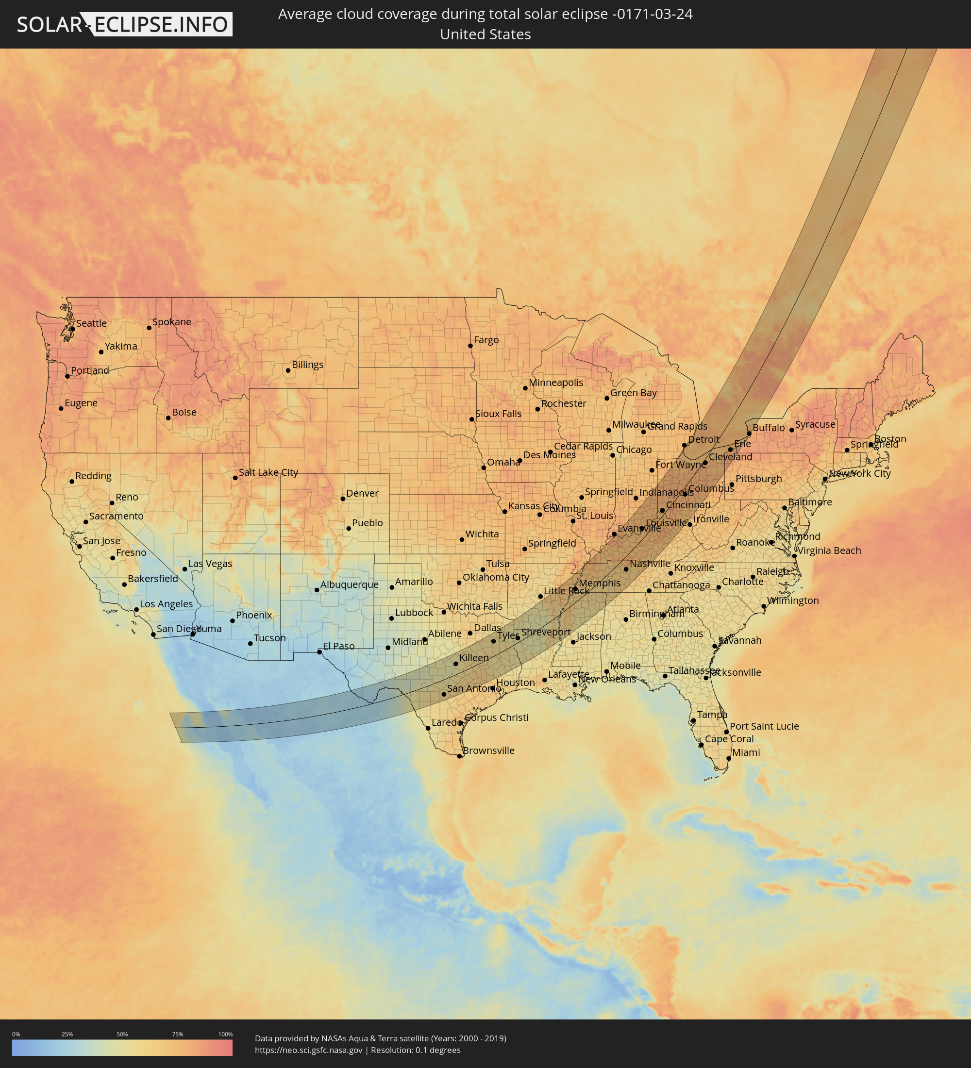 United States
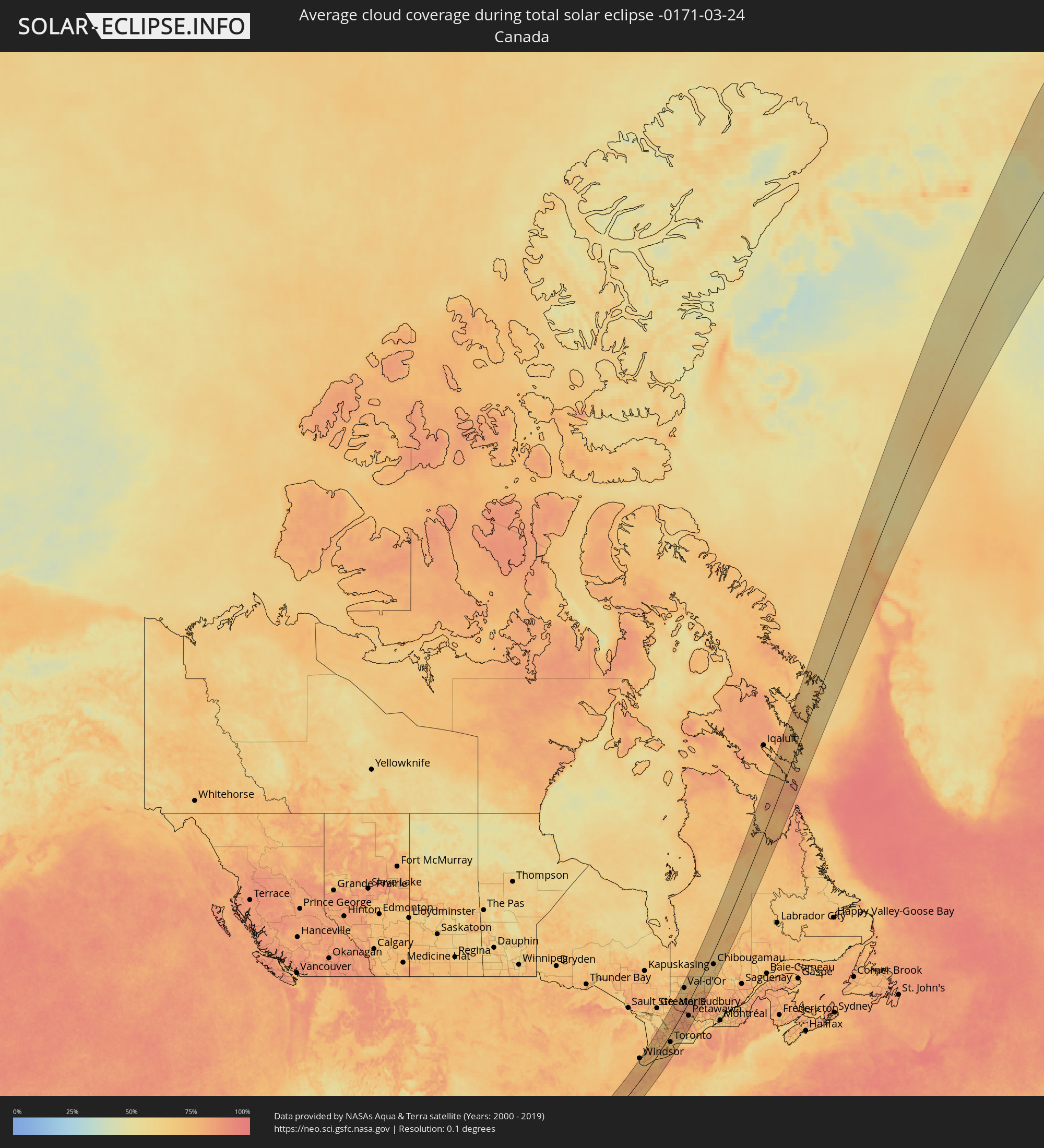 Canada
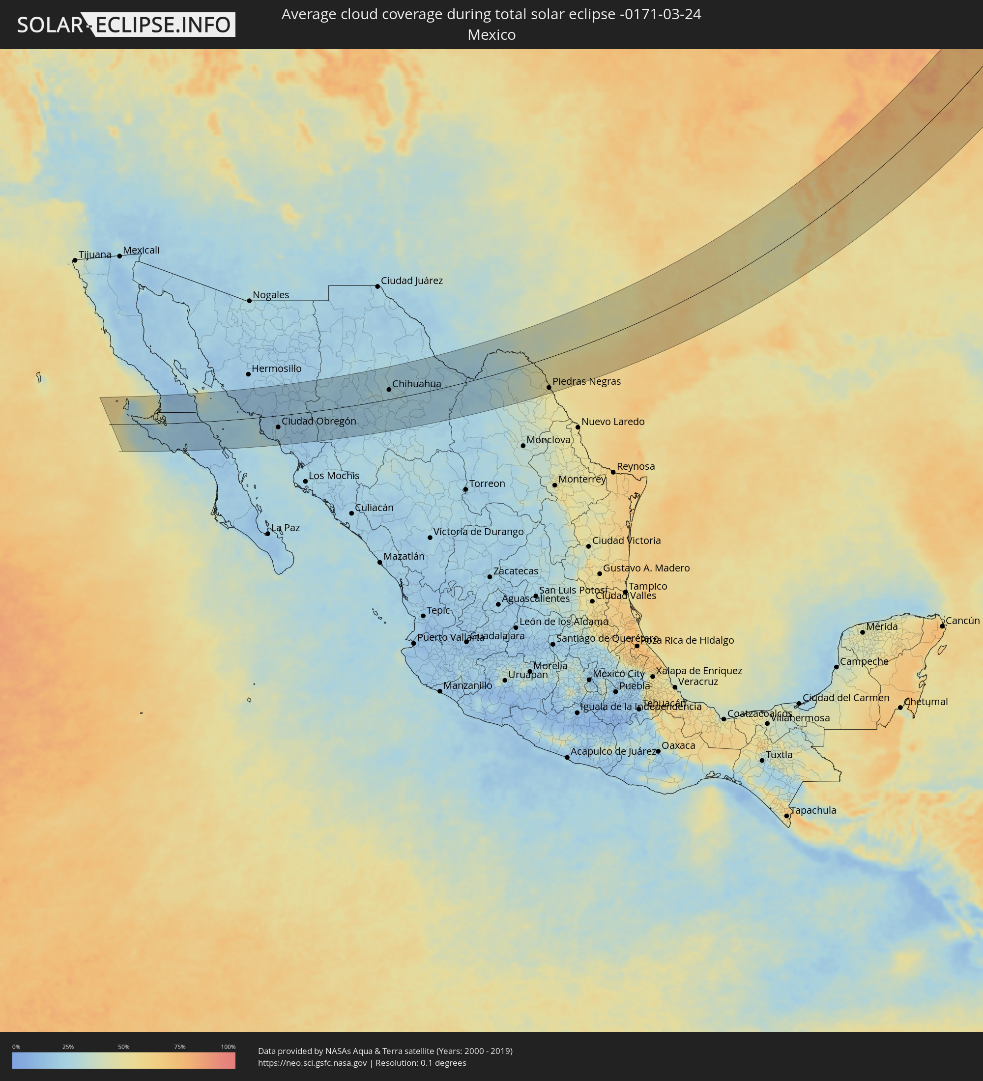 Mexico
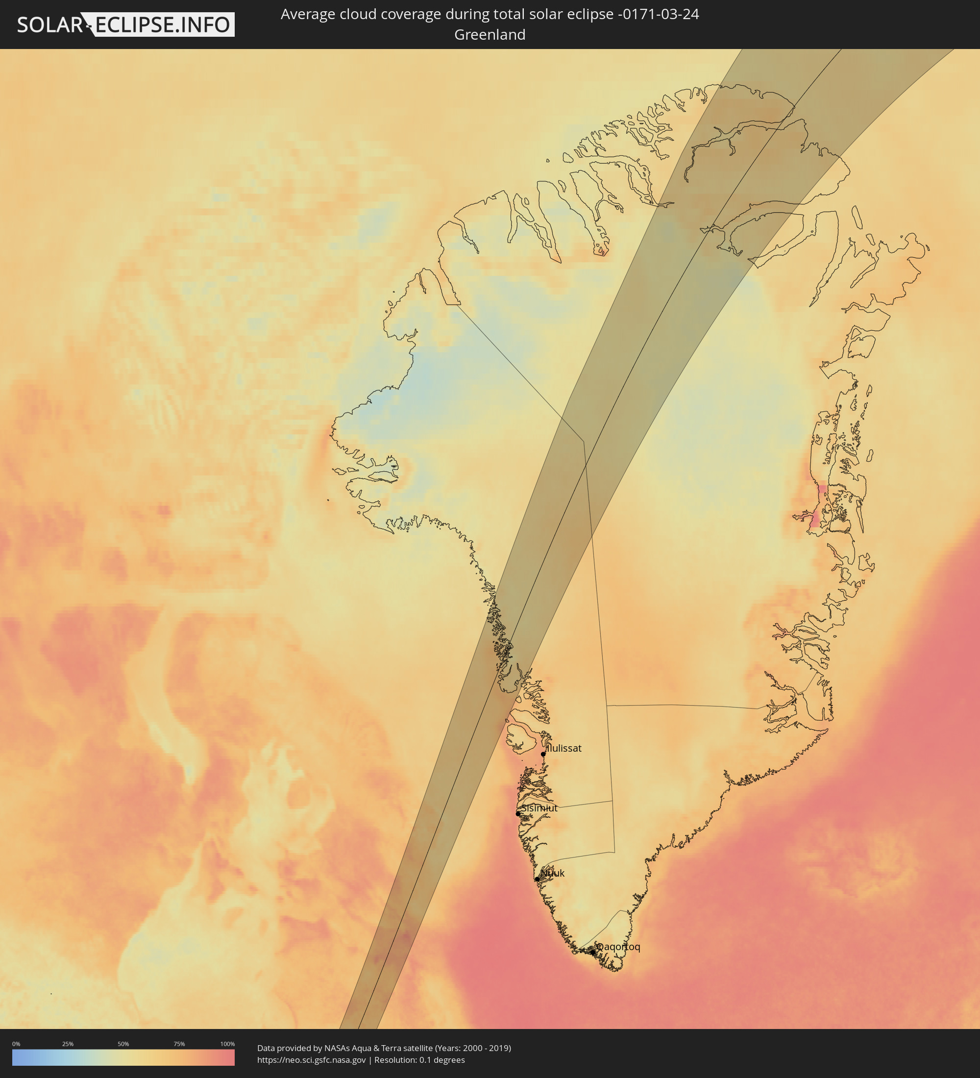 Greenland
Cities inside the path of the eclipse
The following table shows all locations with a population of more than 5,000 inside the eclipse path. Cities which have more than 100,000 inhabitants are marked bold. A click at the locations opens a detailed map.
| City | Type | Eclipse duration | Local time of max. eclipse | Distance to central line | Ø Cloud coverage |
|
San Luis, Baja California
|
total | - | 06:04:06 UTC-07:48 | 91 km | 13% |
|
Villa Alberto Andrés Alvarado Arámburo, Baja California Sur
|
total | - | 06:45:17 UTC-07:05 | 2 km | 20% |
|
Santa Rosalia, Baja California Sur
|
total | - | 06:44:53 UTC-07:05 | 38 km | 17% |
|
Heroica Guaymas, Sonora
|
total | - | 06:27:45 UTC-07:23 | 17 km | 25% |
|
Empalme, Sonora
|
total | - | 06:27:50 UTC-07:23 | 21 km | 23% |
|
Potam, Sonora
|
total | - | 06:27:21 UTC-07:23 | 20 km | 18% |
|
Vicam, Sonora
|
total | - | 06:27:23 UTC-07:23 | 20 km | 20% |
|
San Ignacio Río Muerto, Sonora
|
total | - | 06:27:02 UTC-07:23 | 45 km | 20% |
|
Campo Sesenta, Sonora
|
total | - | 06:27:06 UTC-07:23 | 43 km | 23% |
|
Pueblo Yaqui, Sonora
|
total | - | 06:26:58 UTC-07:23 | 54 km | 22% |
|
Cocorit, Sonora
|
total | - | 06:27:20 UTC-07:23 | 30 km | 21% |
|
Ciudad Obregón, Sonora
|
total | - | 06:27:11 UTC-07:23 | 40 km | 23% |
|
El Tobarito, Sonora
|
total | - | 06:27:00 UTC-07:23 | 54 km | 23% |
|
Marte R. Gómez (Tobarito), Sonora
|
total | - | 06:27:00 UTC-07:23 | 54 km | 23% |
|
Villa Juarez, Sonora
|
total | - | 06:26:38 UTC-07:23 | 81 km | 20% |
|
Bacobampo, Sonora
|
total | - | 06:26:25 UTC-07:23 | 99 km | 19% |
|
Navojoa, Sonora
|
total | - | 06:26:36 UTC-07:23 | 92 km | 18% |
|
Creel, Chihuahua
|
total | - | 06:46:14 UTC-07:05 | 40 km | 19% |
|
Adolfo López Mateos, Chihuahua
|
total | - | 06:47:29 UTC-07:05 | 33 km | 22% |
|
Cuauhtémoc, Chihuahua
|
total | - | 06:47:29 UTC-07:05 | 20 km | 24% |
|
Anáhuac, Chihuahua
|
total | - | 06:47:39 UTC-07:05 | 26 km | 26% |
|
Valentín Gómez Farías, Chihuahua
|
total | - | 06:47:14 UTC-07:05 | 6 km | 24% |
|
Chihuahua, Chihuahua
|
total | - | 06:48:04 UTC-07:05 | 31 km | 25% |
|
Ampliación Colonia Lázaro Cárdenas, Chihuahua
|
total | - | 06:47:46 UTC-07:05 | 6 km | 24% |
|
Rosales, Chihuahua
|
total | - | 06:47:27 UTC-07:05 | 28 km | 25% |
|
Naica, Chihuahua
|
total | - | 06:46:55 UTC-07:05 | 65 km | 24% |
|
Pedro Meoqui, Chihuahua
|
total | - | 06:47:38 UTC-07:05 | 19 km | 23% |
|
Ciudad Delicias, Chihuahua
|
total | - | 06:47:29 UTC-07:05 | 29 km | 25% |
|
Jiménez, Chihuahua
|
total | - | 06:47:45 UTC-07:05 | 15 km | 24% |
|
Saucillo, Chihuahua
|
total | - | 06:47:16 UTC-07:05 | 50 km | 23% |
|
Ciudad Camargo, Chihuahua
|
total | - | 06:46:43 UTC-07:05 | 91 km | 22% |
|
Ojinaga, Chihuahua
|
total | - | 06:50:06 UTC-07:05 | 101 km | 25% |
|
Manuel Ojinaga, Chihuahua
|
total | - | 06:50:08 UTC-07:05 | 98 km | 24% |
|
Ciudad Acuña, Coahuila
|
total | - | 07:20:03 UTC-06:36 | 19 km | 45% |
|
Zaragoza, Coahuila
|
total | - | 07:18:37 UTC-06:36 | 108 km | 46% |
|
Del Rio, Texas
|
total | - | 07:56:45 UTC-06:00 | 17 km | 46% |
|
Piedras Negras, Coahuila
|
total | - | 07:19:09 UTC-06:36 | 98 km | 49% |
|
San Antonio, Texas
|
total | - | 07:57:56 UTC-06:00 | 89 km | 57% |
|
New Braunfels, Texas
|
total | - | 07:58:37 UTC-06:00 | 74 km | 60% |
|
San Marcos, Texas
|
total | - | 07:59:02 UTC-06:00 | 62 km | 60% |
|
Austin, Texas
|
total | - | 07:59:50 UTC-06:00 | 30 km | 60% |
|
Killeen, Texas
|
total | - | 08:01:23 UTC-06:00 | 56 km | 52% |
|
Round Rock, Texas
|
total | - | 08:00:18 UTC-06:00 | 8 km | 57% |
|
Temple, Texas
|
total | - | 08:01:33 UTC-06:00 | 39 km | 55% |
|
Waco, Texas
|
total | - | 08:02:29 UTC-06:00 | 76 km | 57% |
|
College Station, Texas
|
total | - | 08:01:15 UTC-06:00 | 50 km | 65% |
|
Huntsville, Texas
|
total | - | 08:01:52 UTC-06:00 | 73 km | 61% |
|
Conroe, Texas
|
total | - | 08:01:10 UTC-06:00 | 118 km | 63% |
|
Tyler, Texas
|
total | - | 08:05:02 UTC-06:00 | 76 km | 57% |
|
Longview, Texas
|
total | - | 08:05:39 UTC-06:00 | 64 km | 55% |
|
Lufkin, Texas
|
total | - | 08:03:29 UTC-06:00 | 49 km | 56% |
|
Texarkana, Texas
|
total | - | 08:07:49 UTC-06:00 | 119 km | 53% |
|
Shreveport, Louisiana
|
total | - | 08:06:19 UTC-06:00 | 19 km | 53% |
|
Monroe, Louisiana
|
total | - | 08:07:23 UTC-06:00 | 64 km | 50% |
|
Pine Bluff, Arkansas
|
total | - | 08:10:44 UTC-06:00 | 86 km | 54% |
|
Memphis, Tennessee
|
total | - | 08:13:56 UTC-06:00 | 57 km | 62% |
|
Southaven, Mississippi
|
total | - | 08:13:39 UTC-06:00 | 41 km | 63% |
|
Bartlett, Tennessee
|
total | - | 08:14:10 UTC-06:00 | 51 km | 60% |
|
Collierville, Tennessee
|
total | - | 08:14:01 UTC-06:00 | 25 km | 60% |
|
Jackson, Tennessee
|
total | - | 08:15:47 UTC-06:00 | 23 km | 64% |
|
Florence, Alabama
|
total | - | 08:15:08 UTC-06:00 | 114 km | 62% |
|
Clarksville, Tennessee
|
total | - | 08:18:45 UTC-06:00 | 7 km | 69% |
|
Owensboro, Kentucky
|
total | - | 08:21:22 UTC-06:00 | 88 km | 78% |
|
Columbia, Tennessee
|
total | - | 08:17:15 UTC-06:00 | 86 km | 67% |
|
Franklin, Tennessee
|
total | - | 08:17:59 UTC-06:00 | 72 km | 66% |
|
Nashville, Tennessee
|
total | - | 08:18:31 UTC-06:00 | 58 km | 65% |
|
Hendersonville, Tennessee
|
total | - | 08:18:56 UTC-06:00 | 57 km | 65% |
|
Smyrna, Tennessee
|
total | - | 08:18:24 UTC-06:00 | 89 km | 66% |
|
Bowling Green, Kentucky
|
total | - | 08:20:25 UTC-06:00 | 15 km | 76% |
|
Murfreesboro, Tennessee
|
total | - | 08:18:14 UTC-06:00 | 108 km | 65% |
|
Columbus, Indiana
|
total | - | 09:25:10 UTC-05:00 | 115 km | 76% |
|
Louisville, Kentucky
|
total | - | 09:23:28 UTC-05:00 | 36 km | 73% |
|
Richmond, Indiana
|
total | - | 09:27:17 UTC-05:00 | 91 km | 77% |
|
Hamilton, Ohio
|
total | - | 09:26:45 UTC-05:00 | 39 km | 75% |
|
Lexington-Fayette, Kentucky
|
total | - | 09:24:14 UTC-05:00 | 65 km | 79% |
|
Cincinnati, Ohio
|
total | - | 09:26:23 UTC-05:00 | 15 km | 71% |
|
Middletown, Ohio
|
total | - | 09:27:07 UTC-05:00 | 36 km | 75% |
|
Dayton, Ohio
|
total | - | 09:27:47 UTC-05:00 | 39 km | 74% |
|
Lima, Ohio
|
total | - | 09:29:46 UTC-05:00 | 99 km | 78% |
|
Springfield, Ohio
|
total | - | 09:28:27 UTC-05:00 | 24 km | 78% |
|
Findlay, Ohio
|
total | - | 09:30:45 UTC-05:00 | 88 km | 77% |
|
Toledo, Ohio
|
total | - | 09:32:02 UTC-05:00 | 122 km | 75% |
|
Marion, Ohio
|
total | - | 09:30:22 UTC-05:00 | 23 km | 80% |
|
Dublin, Ohio
|
total | - | 09:29:26 UTC-05:00 | 11 km | 76% |
|
Delaware, Ohio
|
total | - | 09:29:52 UTC-05:00 | 1 km | 78% |
|
Amherstburg, Ontario
|
total | - | 09:33:22 UTC-05:00 | 116 km | 72% |
|
Windsor, Ontario
|
total | - | 09:33:45 UTC-05:00 | 125 km | 74% |
|
Columbus, Ohio
|
total | - | 09:29:16 UTC-05:00 | 28 km | 75% |
|
Westerville, Ohio
|
total | - | 09:29:39 UTC-05:00 | 22 km | 74% |
|
Reynoldsburg, Ohio
|
total | - | 09:29:26 UTC-05:00 | 41 km | 76% |
|
Lancaster, Ohio
|
total | - | 09:29:10 UTC-05:00 | 72 km | 75% |
|
Mansfield, Ohio
|
total | - | 09:31:16 UTC-05:00 | 8 km | 79% |
|
Sarnia, Ontario
|
total | - | 09:35:36 UTC-05:00 | 124 km | 74% |
|
Newark, Ohio
|
total | - | 09:30:01 UTC-05:00 | 62 km | 78% |
|
Lorain, Ohio
|
total | - | 09:32:55 UTC-05:00 | 14 km | 74% |
|
Camlachie, Ontario
|
total | - | 09:35:57 UTC-05:00 | 111 km | 76% |
|
Lambton Shores, Ontario
|
total | - | 09:36:24 UTC-05:00 | 103 km | 81% |
|
Strongsville, Ohio
|
total | - | 09:32:58 UTC-05:00 | 18 km | 79% |
|
Goderich, Ontario
|
total | - | 09:37:42 UTC-05:00 | 122 km | 75% |
|
Cleveland, Ohio
|
total | - | 09:33:28 UTC-05:00 | 16 km | 76% |
|
Euclid, Ohio
|
total | - | 09:33:48 UTC-05:00 | 22 km | 75% |
|
Akron, Ohio
|
total | - | 09:32:50 UTC-05:00 | 55 km | 78% |
|
South Huron, Ontario
|
total | - | 09:37:05 UTC-05:00 | 83 km | 78% |
|
Canton, Ohio
|
total | - | 09:32:25 UTC-05:00 | 83 km | 78% |
|
Mentor, Ohio
|
total | - | 09:34:07 UTC-05:00 | 30 km | 74% |
|
Huron East, Ontario
|
total | - | 09:37:51 UTC-05:00 | 86 km | 74% |
|
London, Ontario
|
total | - | 09:36:43 UTC-05:00 | 44 km | 78% |
|
St. Thomas, Ontario
|
total | - | 09:36:23 UTC-05:00 | 28 km | 78% |
|
Dorchester, Ontario
|
total | - | 09:36:53 UTC-05:00 | 32 km | 78% |
|
Aylmer, Ontario
|
total | - | 09:36:33 UTC-05:00 | 14 km | 77% |
|
North Perth, Ontario
|
total | - | 09:38:23 UTC-05:00 | 69 km | 75% |
|
Stratford, Ontario
|
total | - | 09:37:43 UTC-05:00 | 47 km | 74% |
|
Owen Sound, Ontario
|
total | - | 09:39:59 UTC-05:00 | 116 km | 80% |
|
Ingersoll, Ontario
|
total | - | 09:37:09 UTC-05:00 | 23 km | 77% |
|
Warren, Ohio
|
total | - | 09:33:48 UTC-05:00 | 93 km | 77% |
|
Woodstock, Ontario
|
total | - | 09:37:28 UTC-05:00 | 20 km | 75% |
|
Youngstown, Ohio
|
total | - | 09:33:42 UTC-05:00 | 113 km | 77% |
|
Waterloo, Ontario
|
total | - | 09:38:20 UTC-05:00 | 23 km | 76% |
|
Kitchener, Ontario
|
total | - | 09:38:15 UTC-05:00 | 21 km | 76% |
|
Paris, Ontario
|
total | - | 09:37:57 UTC-05:00 | 2 km | 73% |
|
Norfolk County, Ontario
|
total | - | 09:37:16 UTC-05:00 | 24 km | 76% |
|
Brant, Ontario
|
total | - | 09:37:52 UTC-05:00 | 8 km | 74% |
|
Cambridge, Ontario
|
total | - | 09:38:19 UTC-05:00 | 3 km | 73% |
|
Brantford, Ontario
|
total | - | 09:37:56 UTC-05:00 | 14 km | 74% |
|
Guelph, Ontario
|
total | - | 09:38:44 UTC-05:00 | 10 km | 74% |
|
Collingwood, Ontario
|
total | - | 09:40:31 UTC-05:00 | 61 km | 78% |
|
Orangeville, Ontario
|
total | - | 09:39:34 UTC-05:00 | 21 km | 77% |
|
Erie, Pennsylvania
|
total | - | 09:36:13 UTC-05:00 | 87 km | 81% |
|
Wasaga Beach, Ontario
|
total | - | 09:40:46 UTC-05:00 | 50 km | 75% |
|
Ancaster, Ontario
|
total | - | 09:38:22 UTC-05:00 | 28 km | 75% |
|
Midland, Ontario
|
total | - | 09:41:20 UTC-05:00 | 54 km | 79% |
|
Angus, Ontario
|
total | - | 09:40:32 UTC-05:00 | 29 km | 75% |
|
Milton, Ontario
|
total | - | 09:39:02 UTC-05:00 | 17 km | 73% |
|
Hamilton, Ontario
|
total | - | 09:38:34 UTC-05:00 | 35 km | 73% |
|
Burlington, Ontario
|
total | - | 09:38:50 UTC-05:00 | 28 km | 72% |
|
Oakville, Ontario
|
total | - | 09:39:06 UTC-05:00 | 35 km | 71% |
|
Barrie, Ontario
|
total | - | 09:40:54 UTC-05:00 | 19 km | 80% |
|
Mississauga, Ontario
|
total | - | 09:39:22 UTC-05:00 | 29 km | 72% |
|
Innisfil, Ontario
|
total | - | 09:40:44 UTC-05:00 | 12 km | 74% |
|
Vaughan, Ontario
|
total | - | 09:40:01 UTC-05:00 | 25 km | 69% |
|
Concord, Ontario
|
total | - | 09:39:58 UTC-05:00 | 28 km | 69% |
|
North Bay, Ontario
|
total | - | 09:44:37 UTC-05:00 | 110 km | 64% |
|
Keswick, Ontario
|
total | - | 09:40:49 UTC-05:00 | 3 km | 73% |
|
Newmarket, Ontario
|
total | - | 09:40:26 UTC-05:00 | 15 km | 72% |
|
Richmond Hill, Ontario
|
total | - | 09:40:08 UTC-05:00 | 27 km | 71% |
|
Orillia, Ontario
|
total | - | 09:41:31 UTC-05:00 | 14 km | 74% |
|
Toronto, Ontario
|
total | - | 09:39:50 UTC-05:00 | 38 km | 69% |
|
Willowdale, Ontario
|
total | - | 09:39:59 UTC-05:00 | 36 km | 69% |
|
East York, Ontario
|
total | - | 09:39:54 UTC-05:00 | 45 km | 69% |
|
Bracebridge, Ontario
|
total | - | 09:42:25 UTC-05:00 | 31 km | 79% |
|
Scarborough, Ontario
|
total | - | 09:40:08 UTC-05:00 | 45 km | 69% |
|
Welland, Ontario
|
total | - | 09:38:40 UTC-05:00 | 92 km | 75% |
|
St. Catharines, Ontario
|
total | - | 09:39:01 UTC-05:00 | 81 km | 73% |
|
Port Colborne, Ontario
|
total | - | 09:38:31 UTC-05:00 | 98 km | 73% |
|
Huntsville, Ontario
|
total | - | 09:43:04 UTC-05:00 | 40 km | 82% |
|
Thorold, Ontario
|
total | - | 09:38:58 UTC-05:00 | 88 km | 75% |
|
Pickering, Ontario
|
total | - | 09:40:29 UTC-05:00 | 46 km | 68% |
|
Uxbridge, Ontario
|
total | - | 09:40:53 UTC-05:00 | 36 km | 75% |
|
Niagara Falls, Ontario
|
total | - | 09:39:04 UTC-05:00 | 98 km | 75% |
|
Niagara Falls, New York
|
total | - | 09:39:04 UTC-05:00 | 99 km | 75% |
|
Ajax, Ontario
|
total | - | 09:40:30 UTC-05:00 | 56 km | 67% |
|
Fort Erie, Ontario
|
total | - | 09:38:49 UTC-05:00 | 119 km | 76% |
|
Tonawanda, New York
|
total | - | 09:39:02 UTC-05:00 | 118 km | 77% |
|
Oshawa, Ontario
|
total | - | 09:40:46 UTC-05:00 | 66 km | 64% |
|
Peterborough, Ontario
|
total | - | 09:42:03 UTC-05:00 | 79 km | 72% |
|
Cobourg, Ontario
|
total | - | 09:41:34 UTC-05:00 | 109 km | 61% |
|
Val-d'Or, Quebec
|
total | - | 09:49:26 UTC-05:00 | 89 km | 68% |
|
Petawawa, Ontario
|
total | - | 09:46:00 UTC-05:00 | 60 km | 72% |
|
Pembroke, Ontario
|
total | - | 09:46:01 UTC-05:00 | 76 km | 67% |
|
Chibougamau, Quebec
|
total | - | 09:55:55 UTC-05:00 | 47 km | 64% |