Totale Sonnenfinsternis vom 27.04.-1159
| Wochentag: | Donnerstag |
| Maximale Dauer der Verfinsterung: | 04m35s |
| Maximale Breite des Finsternispfades: | 218 km |
| Saroszyklus: | 39 |
| Bedeckungsgrad: | 100% |
| Magnitude: | 1.0598 |
| Gamma: | 0.4491 |
Wo kann man die Sonnenfinsternis vom 27.04.-1159 sehen?
Die Sonnenfinsternis am 27.04.-1159 kann man in 39 Ländern als partielle Sonnenfinsternis beobachten.
Der Finsternispfad verläuft durch 6 Länder. Nur in diesen Ländern ist sie als totale Sonnenfinsternis zu sehen.
In den folgenden Ländern ist die Sonnenfinsternis total zu sehen
 Vereinigte Staaten
 Kanada
 Mexiko
 Irland
 Vereinigtes Königreich
 Isle of Man
In den folgenden Ländern ist die Sonnenfinsternis partiell zu sehen
 Russland
 Vereinigte Staaten
 United States Minor Outlying Islands
 Kiribati
 Französisch-Polynesien
 Kanada
 Pitcairninseln
 Mexiko
 Grönland
 Guatemala
 Ecuador
 El Salvador
 Honduras
 Belize
 Nicaragua
 Costa Rica
 Kuba
Kuba
 Panama
 Kolumbien
 Kaimaninseln
 Bahamas
 Jamaika
 Haiti
Haiti
 Turks- und Caicosinseln
 Dominikanische Republik
 Puerto Rico
 Amerikanische Jungferninseln
 Bermuda
 Britische Jungferninseln
 Anguilla
 Saint-Pierre und Miquelon
 Portugal
 Island
 Spanien
 Irland
 Spitzbergen
 Vereinigtes Königreich
 Färöer
 Isle of Man
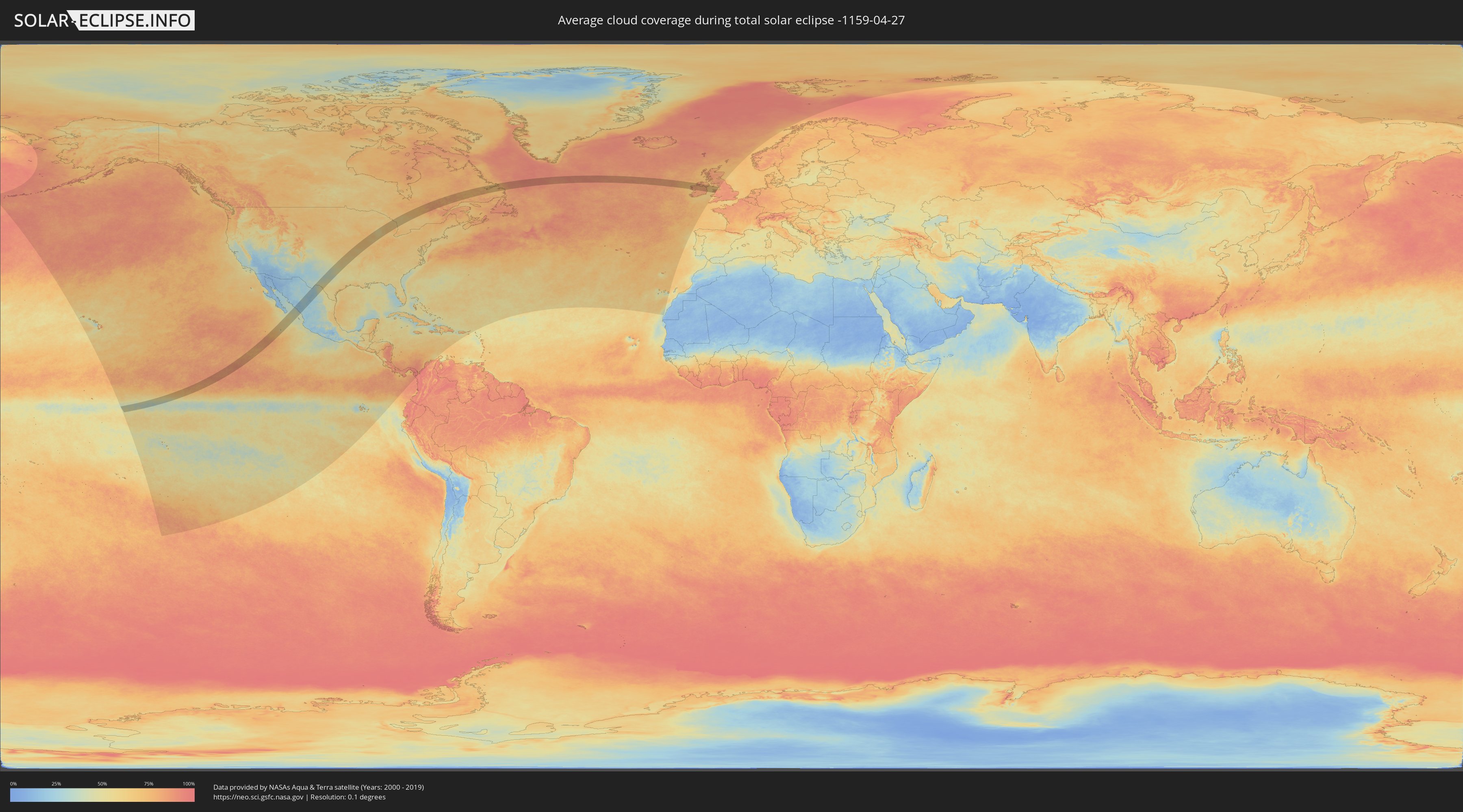
Wie wird das Wetter während der totalen Sonnenfinsternis am 27.04.-1159?
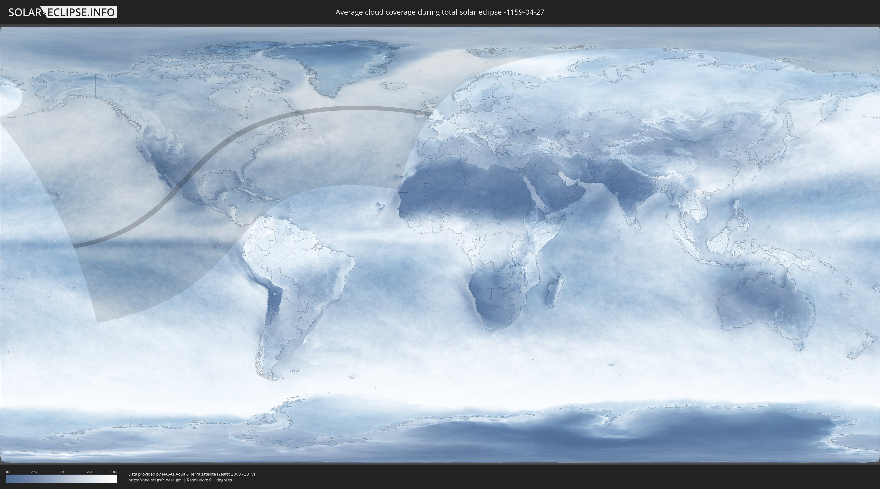
Wo ist der beste Ort, um die totale Sonnenfinsternis vom 27.04.-1159 zu beobachten?
Die folgenden Karten zeigen die durchschnittliche Bewölkung für den Tag, an dem die totale Sonnenfinsternis
stattfindet. Mit Hilfe der Karten lässt sich der Ort entlang des Finsternispfades eingrenzen,
der die besten Aussichen auf einen klaren wolkenfreien Himmel bietet.
Trotzdem muss man immer lokale Gegenenheiten beachten und sollte sich genau über das Wetter an seinem
gewählten Beobachtungsort informieren.
Die Daten stammen von den beiden NASA-Satelliten
AQUA und TERRA
und wurden über einen Zeitraum von 19 Jahren (2000 - 2019) gemittelt.
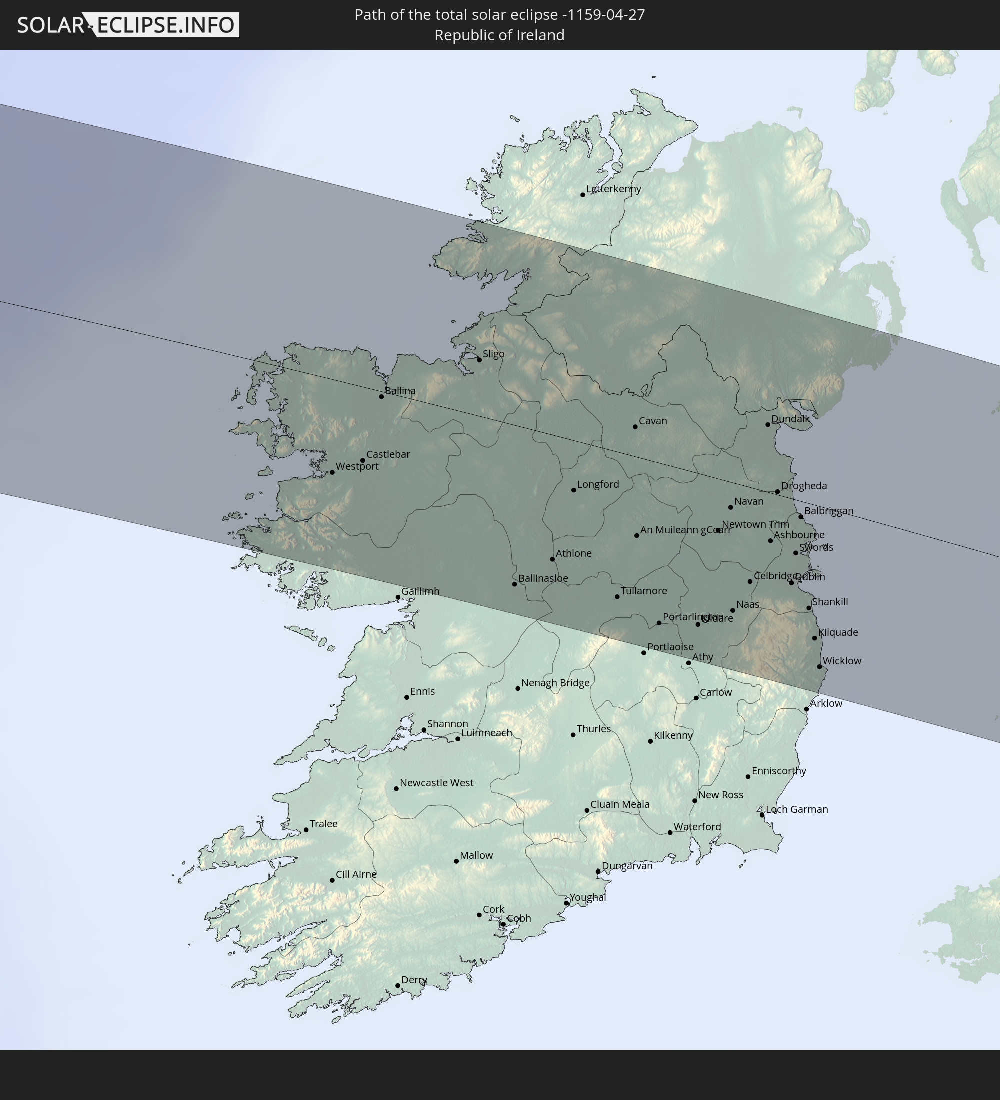
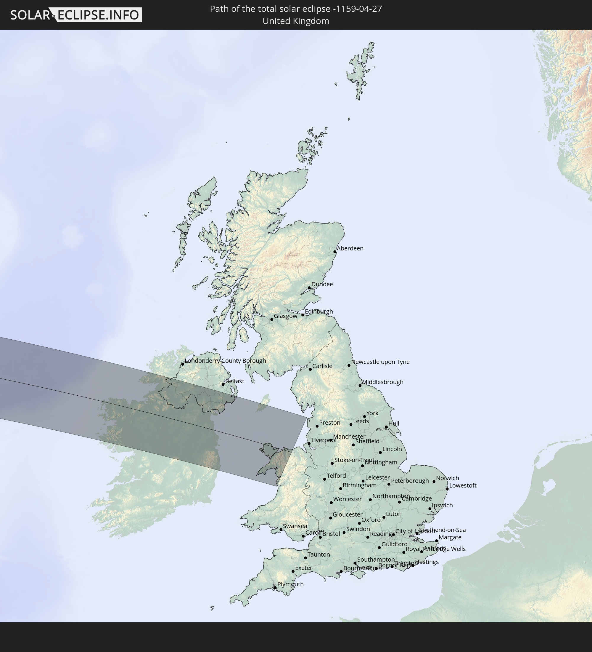
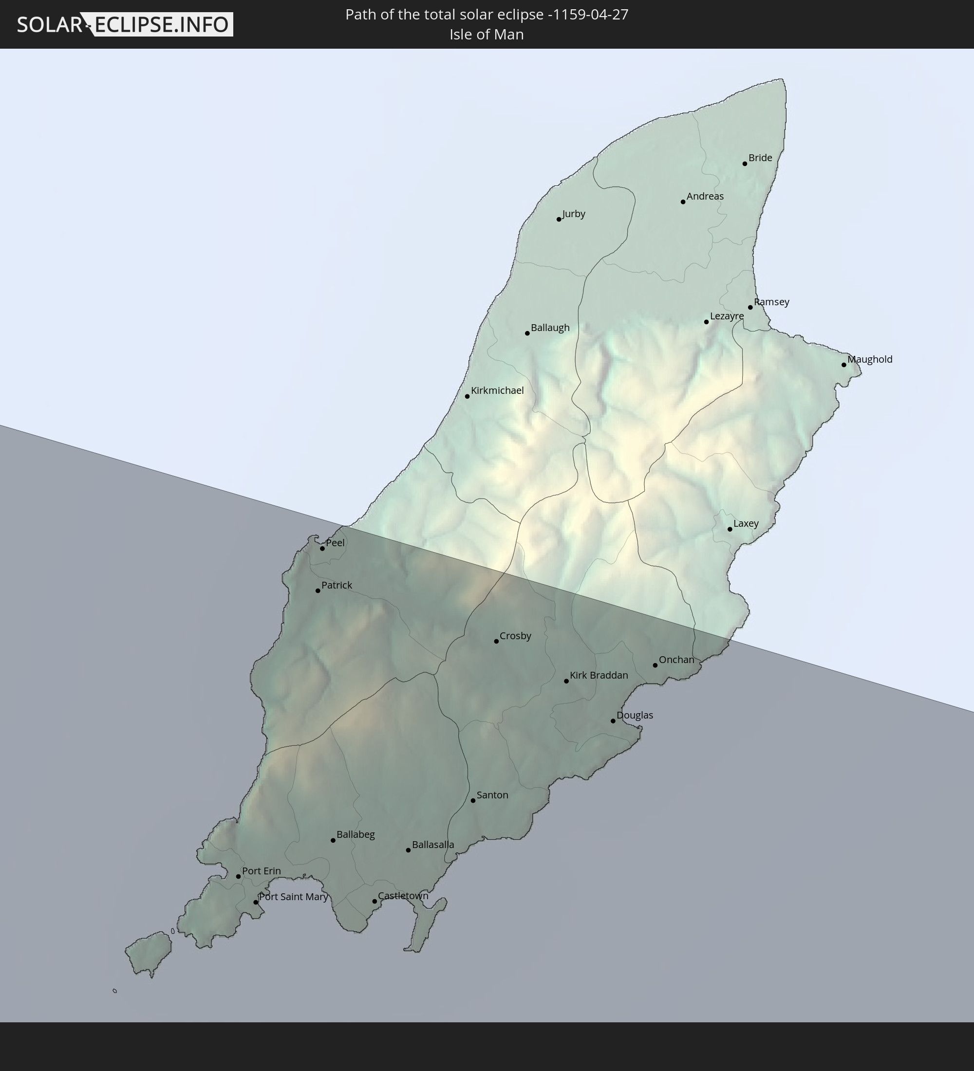
Detaillierte Länderkarten
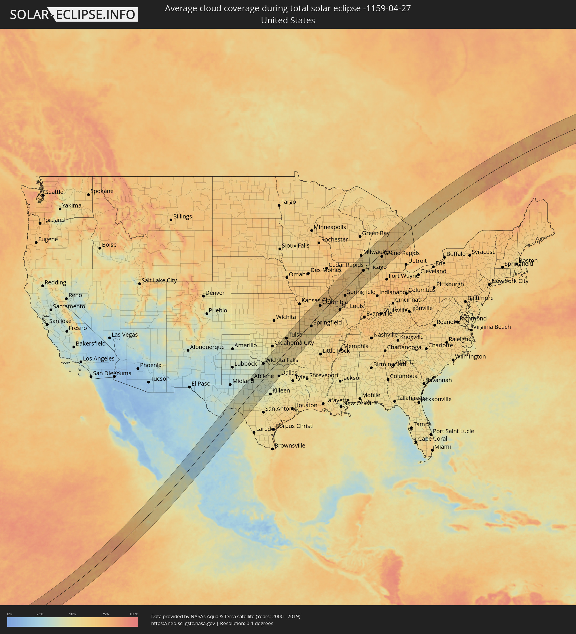 Vereinigte Staaten
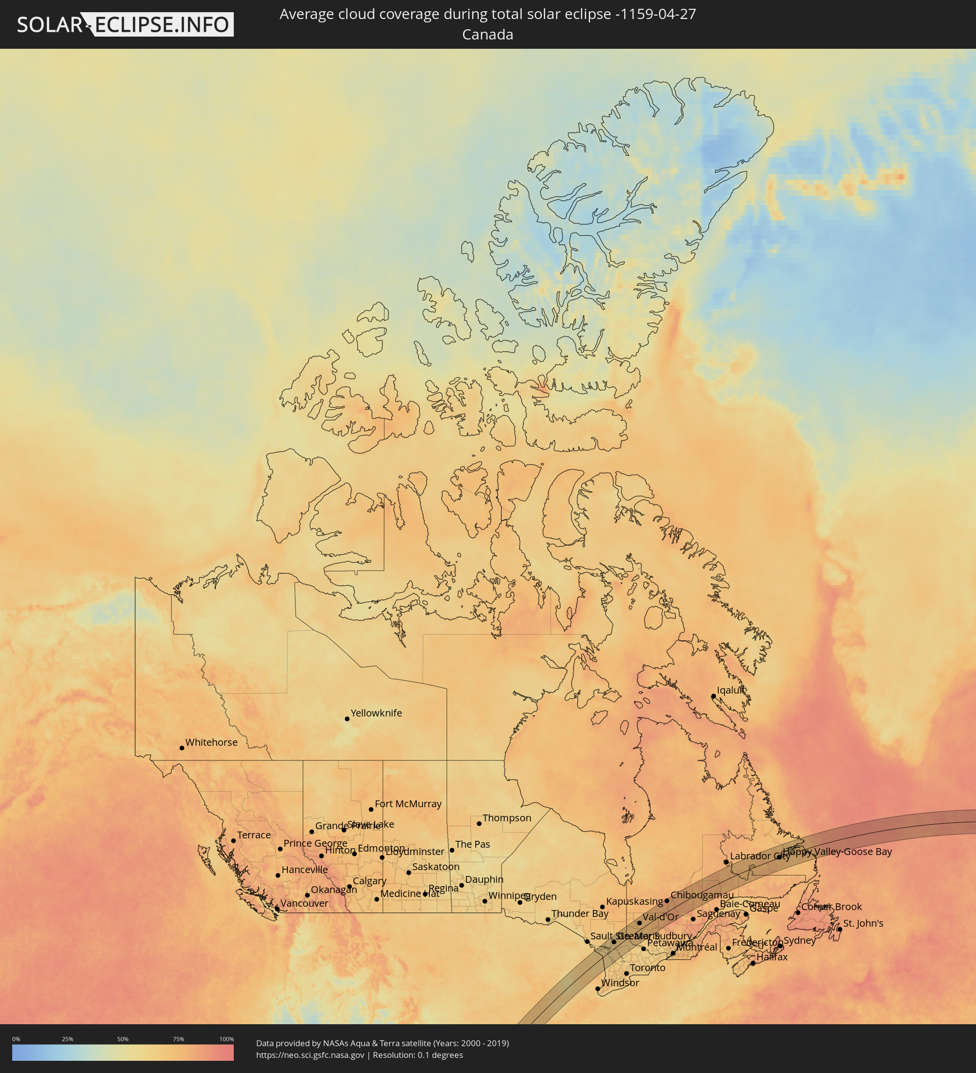 Kanada
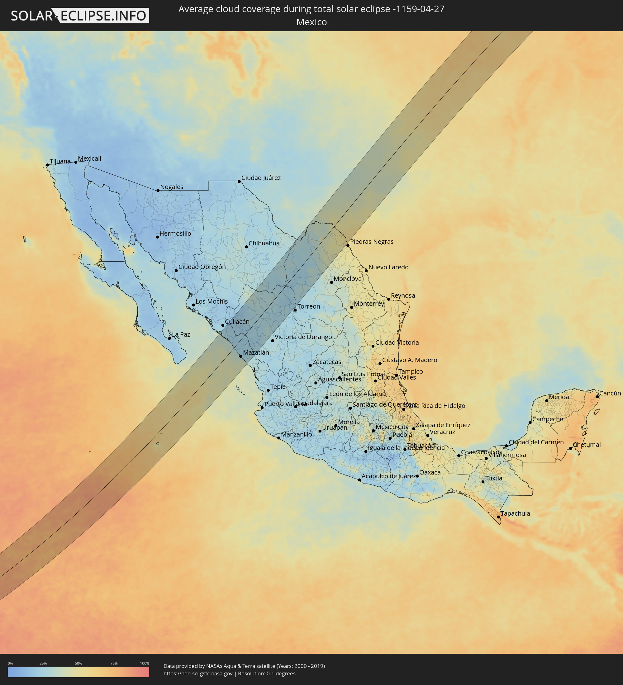 Mexiko
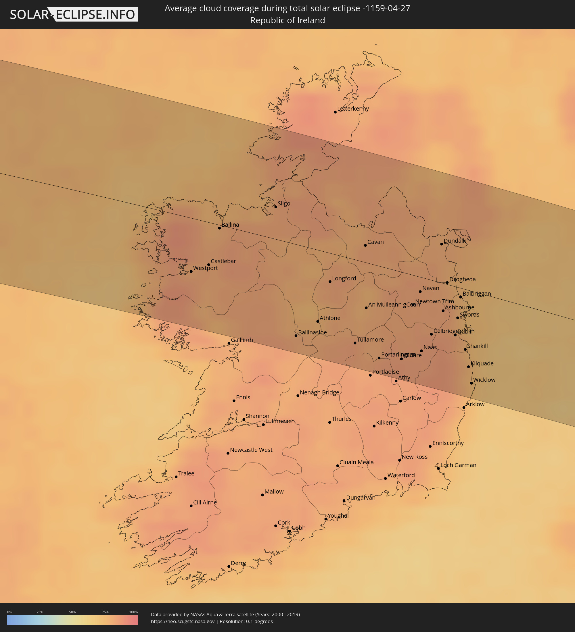 Irland
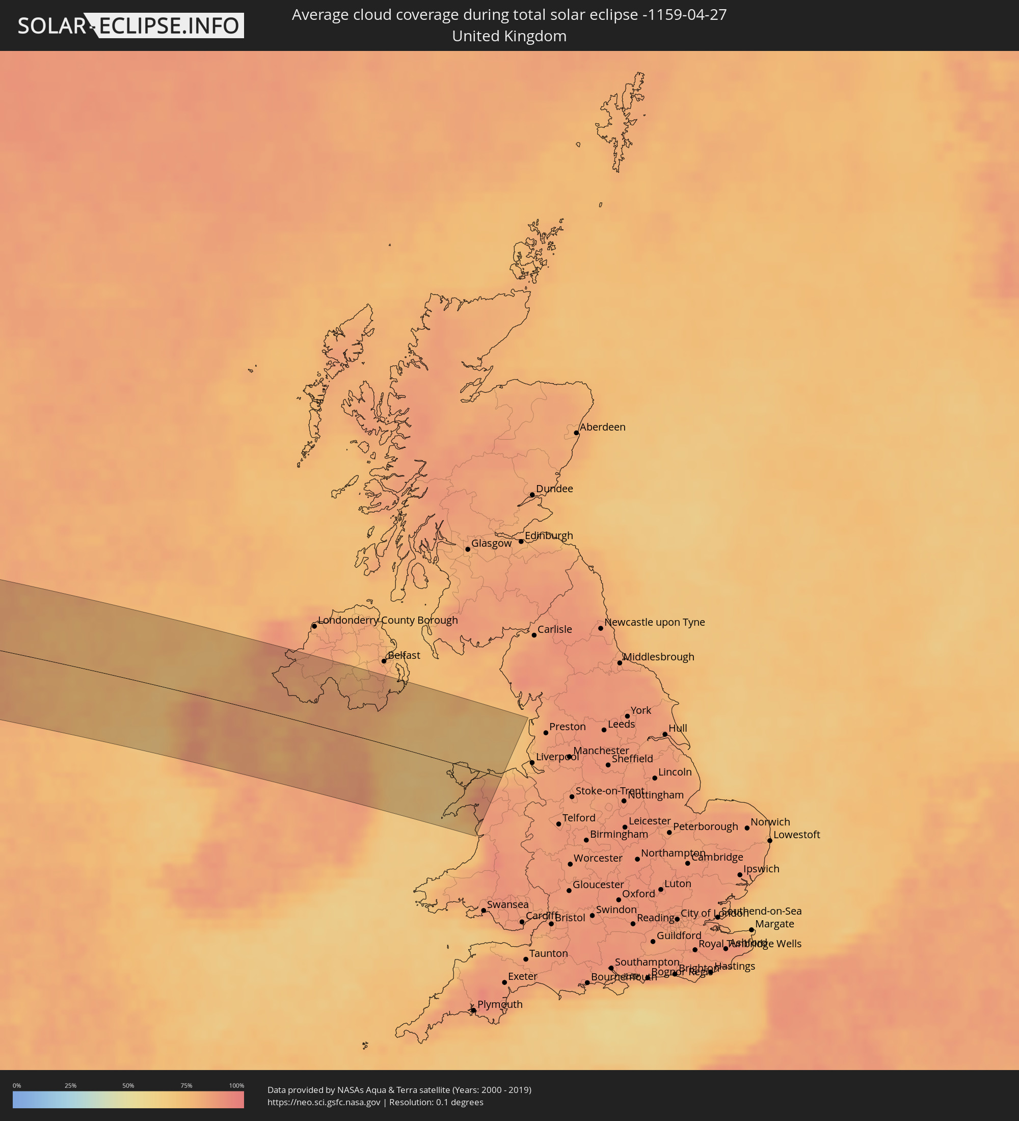 Vereinigtes Königreich
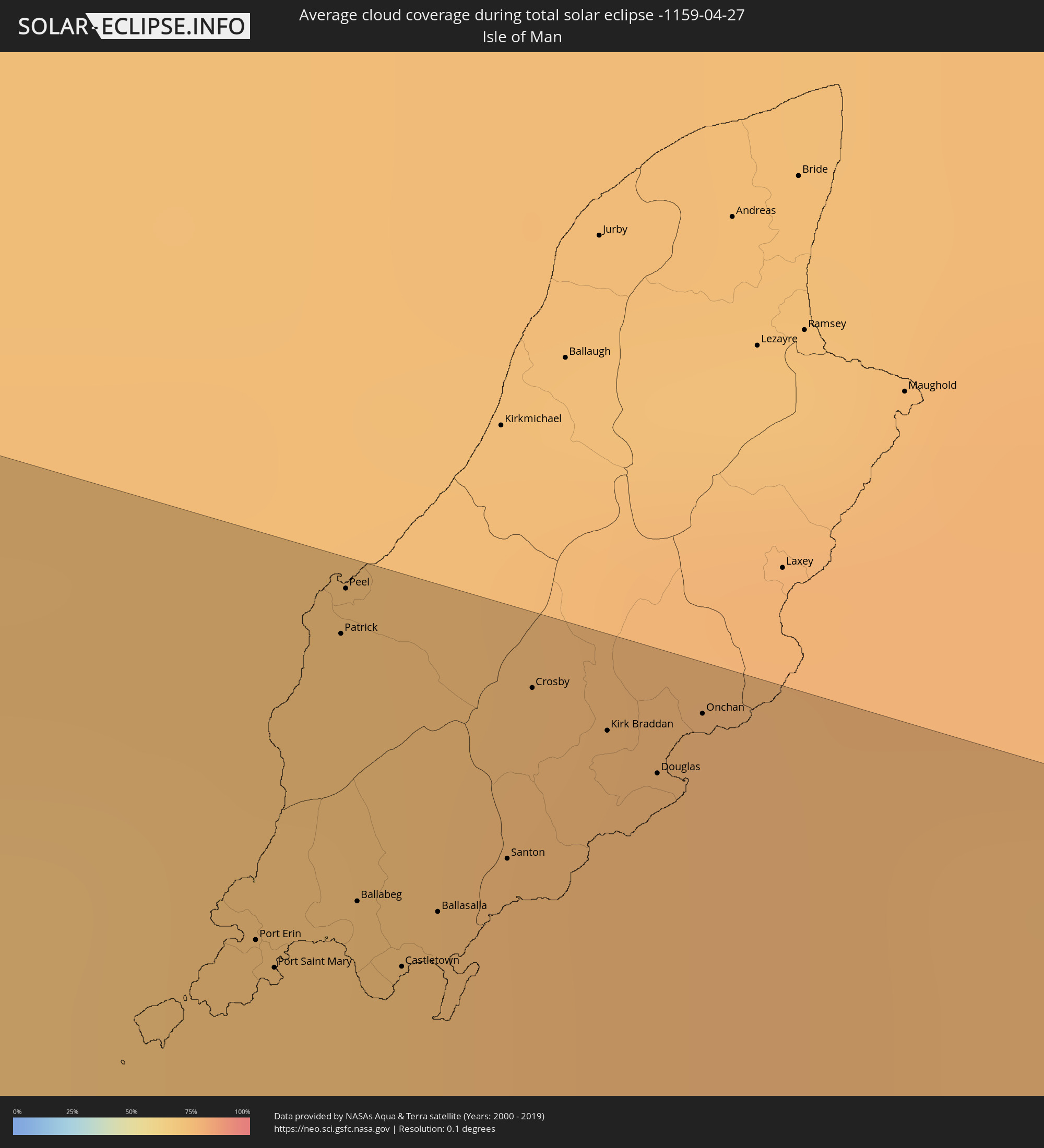 Isle of Man
Orte im Finsternispfad
Die nachfolgene Tabelle zeigt Städte und Orte mit mehr als 5.000 Einwohnern, die sich im Finsternispfad befinden. Städte mit mehr als 100.000 Einwohnern sind dick gekennzeichnet. Mit einem Klick auf den Ort öffnet sich eine Detailkarte die die Lage des jeweiligen Ortes zusammen mit dem Verlauf der zentralen Finsternis präsentiert.
| Ort | Typ | Dauer der Verfinsterung | Ortszeit bei maximaler Verfinsterung | Entfernung zur Zentrallinie | Ø Bewölkung |
|
Villa de Costa Rica, Sinaloa
|
total | - | 09:55:23 UTC-07:05 | 112 km | 25% |
|
Eldorado, Sinaloa
|
total | - | 09:54:53 UTC-07:05 | 91 km | 33% |
|
El Dorado, Sinaloa
|
total | - | 09:54:53 UTC-07:05 | 91 km | 33% |
|
Quila, Sinaloa
|
total | - | 09:55:16 UTC-07:05 | 87 km | 24% |
|
La Constancia, Sinaloa
|
total | - | 09:54:54 UTC-07:05 | 70 km | 30% |
|
El Rosario, Sinaloa
|
total | - | 09:54:59 UTC-07:05 | 72 km | 25% |
|
La Cruz, Sinaloa
|
total | - | 09:54:41 UTC-07:05 | 25 km | 29% |
|
Cosalá, Sinaloa
|
total | - | 09:55:56 UTC-07:05 | 45 km | 23% |
|
Mazatlán, Sinaloa
|
total | - | 09:53:55 UTC-07:05 | 62 km | 36% |
|
Fraccionamiento los Ángeles, Sinaloa
|
total | - | 09:53:55 UTC-07:05 | 71 km | 27% |
|
Villa Unión, Sinaloa
|
total | - | 09:54:04 UTC-07:05 | 80 km | 25% |
|
Concordia, Sinaloa
|
total | - | 09:54:28 UTC-07:05 | 85 km | 25% |
|
Tayoltita, Durango
|
total | - | 10:25:22 UTC-06:36 | 36 km | 21% |
|
Santiago Papasquiaro, Durango
|
total | - | 10:27:58 UTC-06:36 | 9 km | 28% |
|
Santa María del Oro, Durango
|
total | - | 10:29:52 UTC-06:36 | 52 km | 29% |
|
San Miguel de Papasquiaro, Durango
|
total | - | 10:27:38 UTC-06:36 | 30 km | 23% |
|
Nuevo Ideal, Durango
|
total | - | 10:28:06 UTC-06:36 | 47 km | 24% |
|
Canatlán, Durango
|
total | - | 10:27:47 UTC-06:36 | 96 km | 29% |
|
Bermejillo, Durango
|
total | - | 10:32:07 UTC-06:36 | 87 km | 22% |
|
Poanas, Durango
|
total | - | 10:31:54 UTC-06:36 | 97 km | 24% |
|
Tlahualilo de Zaragoza, Durango
|
total | - | 10:32:49 UTC-06:36 | 86 km | 24% |
|
Melchor Múzquiz, Coahuila
|
total | - | 10:39:06 UTC-06:36 | 107 km | 41% |
|
Ciudad Acuña, Coahuila
|
total | - | 10:42:48 UTC-06:36 | 47 km | 51% |
|
Zaragoza, Coahuila
|
total | - | 10:41:11 UTC-06:36 | 108 km | 48% |
|
San Angelo, Texas
|
total | - | 11:24:19 UTC-06:00 | 65 km | 36% |
|
Abilene, Texas
|
total | - | 11:27:14 UTC-06:00 | 83 km | 38% |
|
Wichita Falls, Texas
|
total | - | 11:31:47 UTC-06:00 | 97 km | 41% |
|
Fort Worth, Texas
|
total | - | 11:31:19 UTC-06:00 | 72 km | 49% |
|
Denton, Texas
|
total | - | 11:32:31 UTC-06:00 | 50 km | 50% |
|
Arlington, Texas
|
total | - | 11:31:39 UTC-06:00 | 86 km | 48% |
|
Carrollton, Texas
|
total | - | 11:32:23 UTC-06:00 | 86 km | 51% |
|
Frisco, Texas
|
total | - | 11:32:51 UTC-06:00 | 77 km | 49% |
|
Dallas, Texas
|
total | - | 11:32:12 UTC-06:00 | 104 km | 51% |
|
Plano, Texas
|
total | - | 11:32:48 UTC-06:00 | 95 km | 48% |
|
McKinney, Texas
|
total | - | 11:33:15 UTC-06:00 | 88 km | 50% |
|
Tulsa, Oklahoma
|
total | - | 11:39:30 UTC-06:00 | 83 km | 60% |
|
Broken Arrow, Oklahoma
|
total | - | 11:39:37 UTC-06:00 | 62 km | 62% |
|
Fort Smith, Arkansas
|
total | - | 11:40:33 UTC-06:00 | 81 km | 58% |
|
Springfield, Missouri
|
total | - | 11:45:20 UTC-06:00 | 18 km | 66% |
|
Columbia, Missouri
|
total | - | 11:49:35 UTC-06:00 | 51 km | 68% |
|
O'Fallon, Missouri
|
total | - | 11:51:49 UTC-06:00 | 62 km | 64% |
|
Springfield, Illinois
|
total | - | 11:54:54 UTC-06:00 | 50 km | 69% |
|
Peoria, Illinois
|
total | - | 11:56:16 UTC-06:00 | 17 km | 68% |
|
Bloomington, Illinois
|
total | - | 11:56:51 UTC-06:00 | 35 km | 68% |
|
Decatur, Illinois
|
total | - | 11:56:00 UTC-06:00 | 88 km | 66% |
|
Aurora, Illinois
|
total | - | 11:59:36 UTC-06:00 | 28 km | 69% |
|
Elgin, Illinois
|
total | - | 12:00:02 UTC-06:00 | 48 km | 67% |
|
Joliet, Illinois
|
total | - | 11:59:38 UTC-06:00 | 5 km | 66% |
|
Arlington Heights, Illinois
|
total | - | 12:00:32 UTC-06:00 | 35 km | 69% |
|
Waukegan, Illinois
|
total | - | 12:01:06 UTC-06:00 | 49 km | 62% |
|
Kenosha, Wisconsin
|
total | - | 12:01:25 UTC-06:00 | 66 km | 61% |
|
Racine, Wisconsin
|
total | - | 12:01:39 UTC-06:00 | 75 km | 61% |
|
Evanston, Illinois
|
total | - | 12:00:54 UTC-06:00 | 14 km | 65% |
|
Chicago, Illinois
|
total | - | 12:00:43 UTC-06:00 | 3 km | 65% |
|
Hammond, Indiana
|
total | - | 12:00:35 UTC-06:00 | 33 km | 65% |
|
South Bend, Indiana
|
total | - | 13:02:34 UTC-05:00 | 96 km | 63% |
|
Grand Rapids, Michigan
|
total | - | 13:05:01 UTC-05:00 | 22 km | 64% |
|
Lansing, Michigan
|
total | - | 13:06:22 UTC-05:00 | 101 km | 65% |
|
Rayside-Balfour, Ontario
|
total | - | 13:15:05 UTC-05:00 | 65 km | 61% |
|
Greater Sudbury, Ontario
|
total | - | 13:15:16 UTC-05:00 | 45 km | 61% |
|
Parry Sound, Ontario
|
total | - | 13:15:35 UTC-05:00 | 101 km | 62% |
|
Temiskaming Shores, Ontario
|
total | - | 13:17:49 UTC-05:00 | 76 km | 72% |
|
North Bay, Ontario
|
total | - | 13:17:12 UTC-05:00 | 41 km | 64% |
|
Val-d'Or, Quebec
|
total | - | 13:20:46 UTC-05:00 | 47 km | 71% |
|
Chibougamau, Quebec
|
total | - | 13:26:08 UTC-05:00 | 80 km | 82% |
|
Dolbeau-Mistassini, Quebec
|
total | - | 13:28:17 UTC-05:00 | 99 km | 73% |
|
Happy Valley-Goose Bay, Newfoundland and Labrador
|
total | - | 14:27:32 UTC-04:14 | 1 km | 76% |
|
Castlebar, Connaught
|
total | - | 18:39:10 UTC-00:25 | 33 km | 81% |
|
Ballina, Connaught
|
total | - | 18:38:56 UTC-00:25 | 3 km | 80% |
|
Sligo, Connaught
|
total | - | 18:38:45 UTC-00:25 | 25 km | 80% |
|
Ballinasloe, Connaught
|
total | - | 18:39:34 UTC-00:25 | 73 km | 81% |
|
Athlone, Leinster
|
total | - | 18:39:27 UTC-00:25 | 57 km | 80% |
|
Longford, Leinster
|
total | - | 18:39:11 UTC-00:25 | 23 km | 81% |
|
Enniskillen, Northern Ireland
|
total | - | 19:03:58 UTC+00:00 | 47 km | 79% |
|
Tullamore, Leinster
|
total | - | 18:39:33 UTC-00:25 | 66 km | 84% |
|
Dromore, Northern Ireland
|
total | - | 19:03:48 UTC+00:00 | 68 km | 82% |
|
Cavan, Ulster
|
total | - | 18:38:55 UTC-00:25 | 13 km | 82% |
|
An Muileann gCearr, Leinster
|
total | - | 18:39:19 UTC-00:25 | 36 km | 79% |
|
Omagh, Northern Ireland
|
total | - | 19:03:42 UTC+00:00 | 80 km | 83% |
|
Portarlington, Leinster
|
total | - | 18:39:38 UTC-00:25 | 73 km | 83% |
|
Cherryville, Leinster
|
total | - | 18:39:37 UTC-00:25 | 70 km | 85% |
|
Kildare, Leinster
|
total | - | 18:39:36 UTC-00:25 | 69 km | 85% |
|
Newtown Trim, Leinster
|
total | - | 18:39:14 UTC-00:25 | 24 km | 82% |
|
Dungannon, Northern Ireland
|
total | - | 19:03:45 UTC+00:00 | 78 km | 78% |
|
Coalisland, Northern Ireland
|
total | - | 19:03:42 UTC+00:00 | 84 km | 79% |
|
Clane, Leinster
|
total | - | 18:39:28 UTC-00:25 | 51 km | 83% |
|
Navan, Leinster
|
total | - | 18:39:09 UTC-00:25 | 12 km | 83% |
|
Naas, Leinster
|
total | - | 18:39:32 UTC-00:25 | 58 km | 84% |
|
Armagh, Northern Ireland
|
total | - | 19:03:52 UTC+00:00 | 64 km | 80% |
|
Celbridge, Leinster
|
total | - | 18:39:25 UTC-00:25 | 43 km | 85% |
|
Dunboyne, Leinster
|
total | - | 18:39:21 UTC-00:25 | 35 km | 85% |
|
Portadown, Northern Ireland
|
total | - | 19:03:47 UTC+00:00 | 75 km | 78% |
|
Dundalk, Leinster
|
total | - | 18:38:49 UTC-00:25 | 30 km | 80% |
|
Ashbourne, Leinster
|
total | - | 18:39:15 UTC-00:25 | 22 km | 83% |
|
Craigavon, Northern Ireland
|
total | - | 19:03:45 UTC+00:00 | 79 km | 78% |
|
Drogheda, Leinster
|
total | - | 18:39:03 UTC-00:25 | 1 km | 79% |
|
Firhouse, Leinster
|
total | - | 18:39:26 UTC-00:25 | 46 km | 84% |
|
Newry, Northern Ireland
|
total | - | 19:04:00 UTC+00:00 | 51 km | 80% |
|
Templeogue, Leinster
|
total | - | 18:39:25 UTC-00:25 | 44 km | 84% |
|
Greenhills, Leinster
|
total | - | 18:39:23 UTC-00:25 | 39 km | 84% |
|
Banbridge, Northern Ireland
|
total | - | 19:03:50 UTC+00:00 | 70 km | 80% |
|
Ballymun, Leinster
|
total | - | 18:39:20 UTC-00:25 | 32 km | 84% |
|
Warrenpoint, Northern Ireland
|
total | - | 18:38:42 UTC-00:25 | 44 km | 79% |
|
Dublin, Leinster
|
total | - | 18:39:23 UTC-00:25 | 38 km | 80% |
|
Booterstown
|
total | - | 18:39:24 UTC-00:25 | 41 km | 80% |
|
Balbriggan, Leinster
|
total | - | 18:39:08 UTC-00:25 | 7 km | 78% |
|
Lusk, Leinster
|
total | - | 18:39:12 UTC-00:25 | 16 km | 78% |
|
Donabate, Leinster
|
total | - | 18:39:14 UTC-00:25 | 20 km | 78% |
|
Sallynoggin, Leinster
|
total | - | 18:39:25 UTC-00:25 | 42 km | 77% |
|
Dalkey, Leinster
|
total | - | 18:39:25 UTC-00:25 | 42 km | 77% |
|
Bray, Leinster
|
total | - | 18:39:29 UTC-00:25 | 50 km | 78% |
|
Kilquade
|
total | - | 18:39:34 UTC-00:25 | 61 km | 77% |
|
Kilkeel, Northern Ireland
|
total | - | 19:04:04 UTC+00:00 | 44 km | 79% |
|
Ballynahinch, Northern Ireland
|
total | - | 19:03:45 UTC+00:00 | 82 km | 82% |
|
Newcastle, Northern Ireland
|
total | - | 19:03:55 UTC+00:00 | 63 km | 81% |
|
Downpatrick, Northern Ireland
|
total | - | 19:03:47 UTC+00:00 | 78 km | 79% |
|
Port Erin, Port Erin
|
total | - | 19:03:53 UTC+00:00 | 69 km | 72% |
|
Port Saint Mary, Port St Mary
|
total | - | 19:03:54 UTC+00:00 | 68 km | 74% |
|
Patrick, Patrick
|
total | - | 19:03:47 UTC+00:00 | 83 km | 74% |
|
Peel, Peel
|
total | - | 19:03:46 UTC+00:00 | 85 km | 74% |
|
Ballabeg, Arbory
|
total | - | 19:03:52 UTC+00:00 | 72 km | 74% |
|
Castletown, Castletown
|
total | - | 19:03:53 UTC+00:00 | 69 km | 74% |
|
Holyhead, Wales
|
total | - | 19:04:34 UTC+00:00 | 12 km | 69% |
|
Ballasalla, Malew
|
total | - | 19:03:52 UTC+00:00 | 72 km | 75% |
|
Santon, Santon
|
total | - | 19:03:50 UTC+00:00 | 75 km | 75% |
|
Crosby, Marown
|
total | - | 19:03:47 UTC+00:00 | 83 km | 75% |
|
Kirk Braddan, Braddan
|
total | - | 19:03:47 UTC+00:00 | 82 km | 77% |
|
Douglas, Douglas
|
total | - | 19:03:48 UTC+00:00 | 81 km | 77% |
|
Onchan, Onchan
|
total | - | 19:03:46 UTC+00:00 | 84 km | 77% |
|
Caernarfon, Wales
|
total | - | 19:04:39 UTC+00:00 | 23 km | 79% |
|
Bangor, Wales
|
total | - | 19:04:33 UTC+00:00 | 11 km | 84% |
|
Llandudno, Wales
|
total | - | 19:04:26 UTC+00:00 | 5 km | 79% |
|
Deganwy, Wales
|
total | - | 19:04:27 UTC+00:00 | 2 km | 79% |
|
Colwyn Bay, Wales
|
total | - | 19:04:26 UTC+00:00 | 3 km | 78% |
|
Abergele, Wales
|
total | - | 19:04:26 UTC+00:00 | 5 km | 78% |