Total solar eclipse of 04/27/-1159
| Day of week: | Thursday |
| Maximum duration of eclipse: | 04m35s |
| Maximum width of eclipse path: | 218 km |
| Saros cycle: | 39 |
| Coverage: | 100% |
| Magnitude: | 1.0598 |
| Gamma: | 0.4491 |
Wo kann man die Sonnenfinsternis vom 04/27/-1159 sehen?
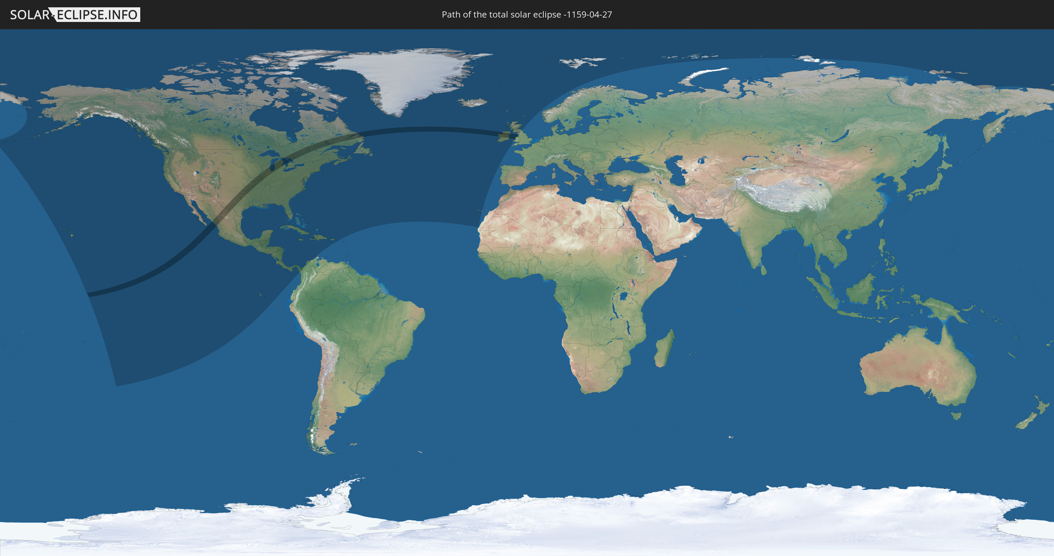
Die Sonnenfinsternis am 04/27/-1159 kann man in 39 Ländern als partielle Sonnenfinsternis beobachten.
Der Finsternispfad verläuft durch 6 Länder. Nur in diesen Ländern ist sie als total Sonnenfinsternis zu sehen.
In den folgenden Ländern ist die Sonnenfinsternis total zu sehen
 United States
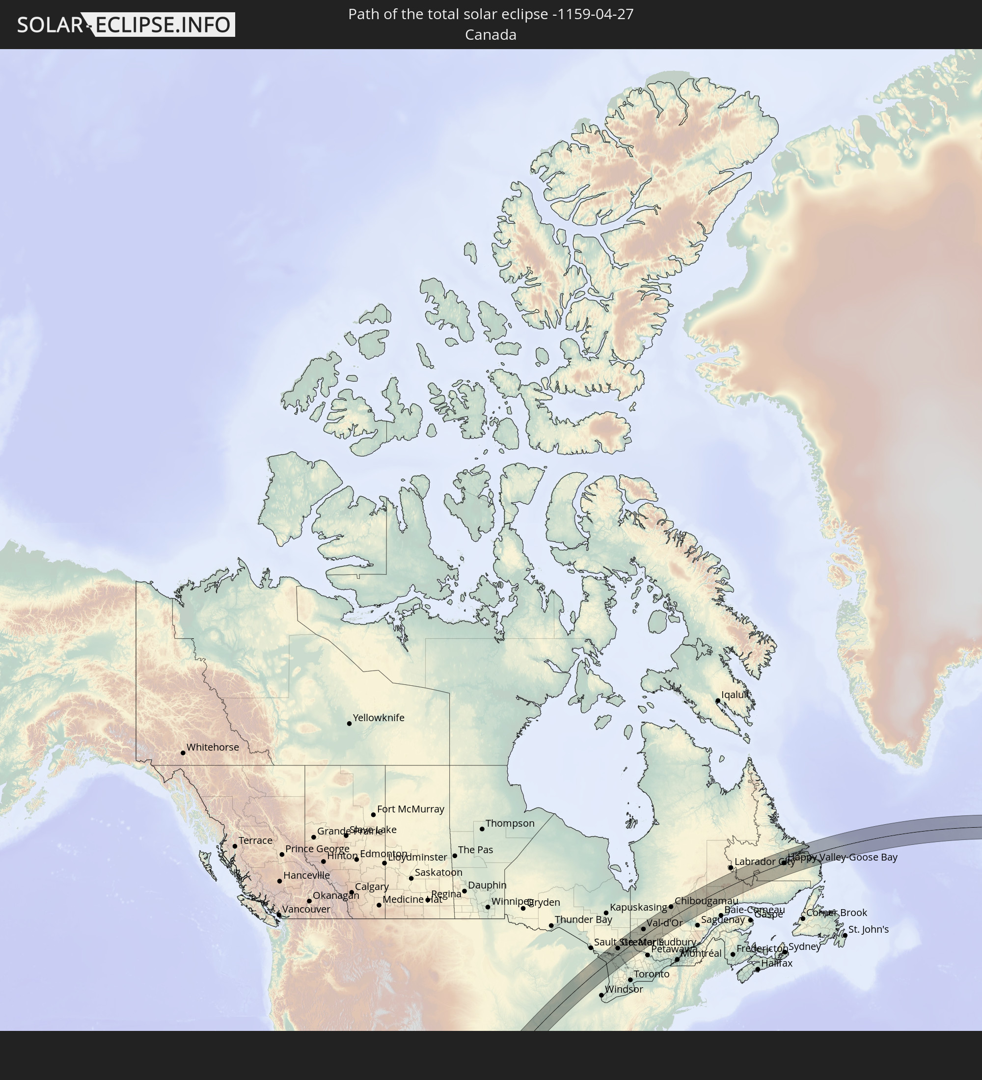 Canada
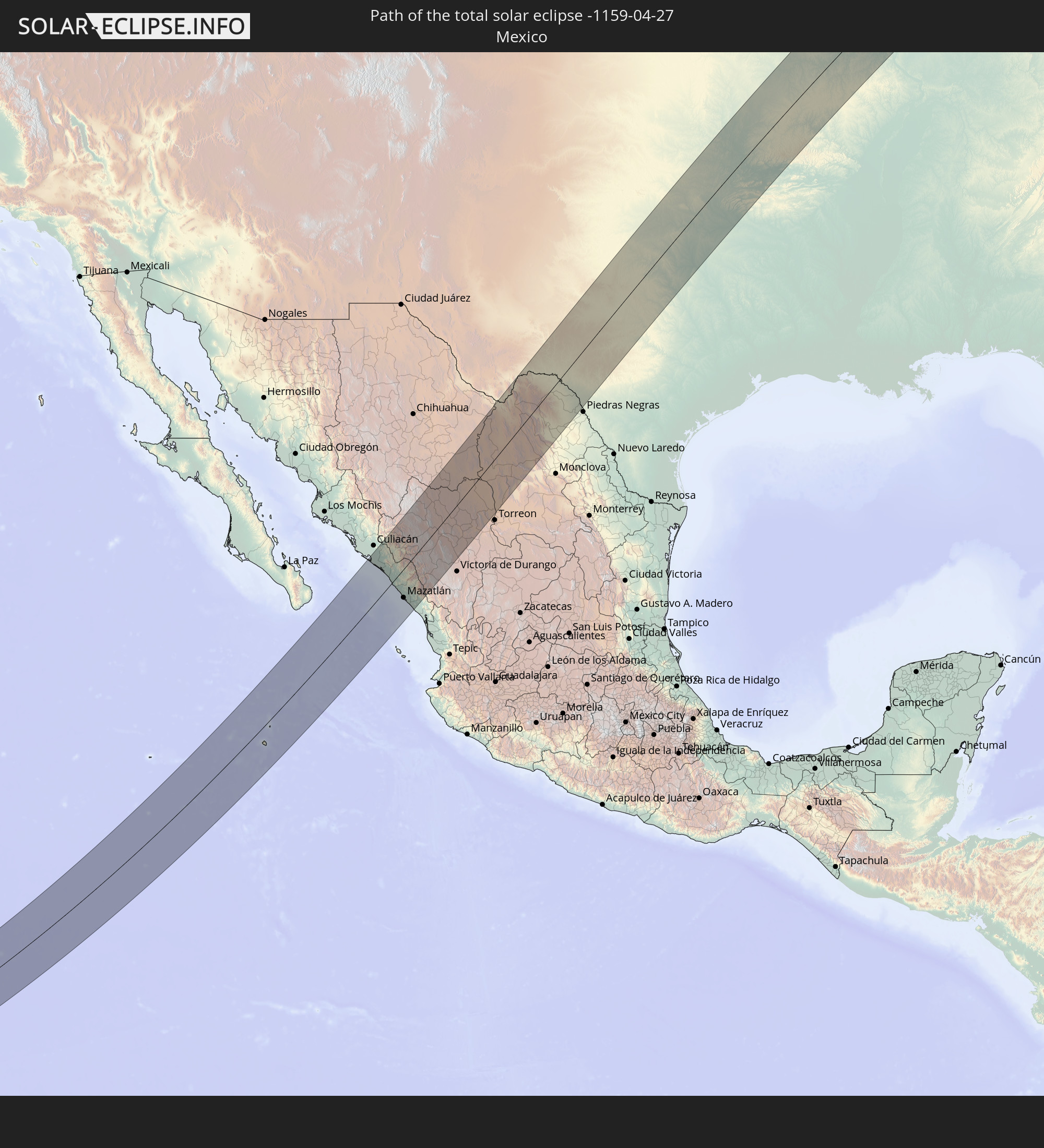 Mexico
 Republic of Ireland
 United Kingdom
 Isle of Man
In den folgenden Ländern ist die Sonnenfinsternis partiell zu sehen
 Russia
 United States
 United States Minor Outlying Islands
 Kiribati
 French Polynesia
 Canada
 Pitcairn Islands
 Mexico
 Greenland
 Guatemala
 Ecuador
 El Salvador
 Honduras
 Belize
 Nicaragua
 Costa Rica
 Cuba
Cuba
 Panama
 Colombia
 Cayman Islands
 The Bahamas
 Jamaica
 Haiti
Haiti
 Turks and Caicos Islands
 Dominican Republic
 Puerto Rico
 United States Virgin Islands
 Bermuda
 British Virgin Islands
 Anguilla
 Saint Pierre and Miquelon
 Portugal
 Iceland
 Spain
Spain
 Republic of Ireland
 Svalbard and Jan Mayen
 United Kingdom
 Faroe Islands
 Isle of Man
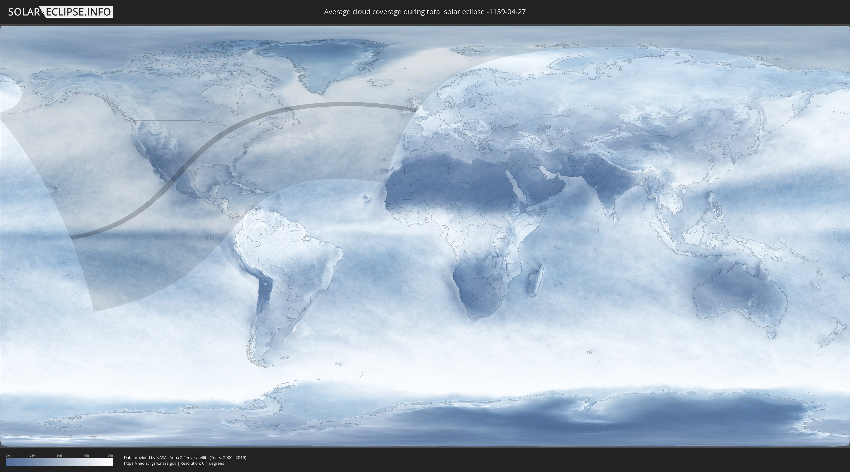
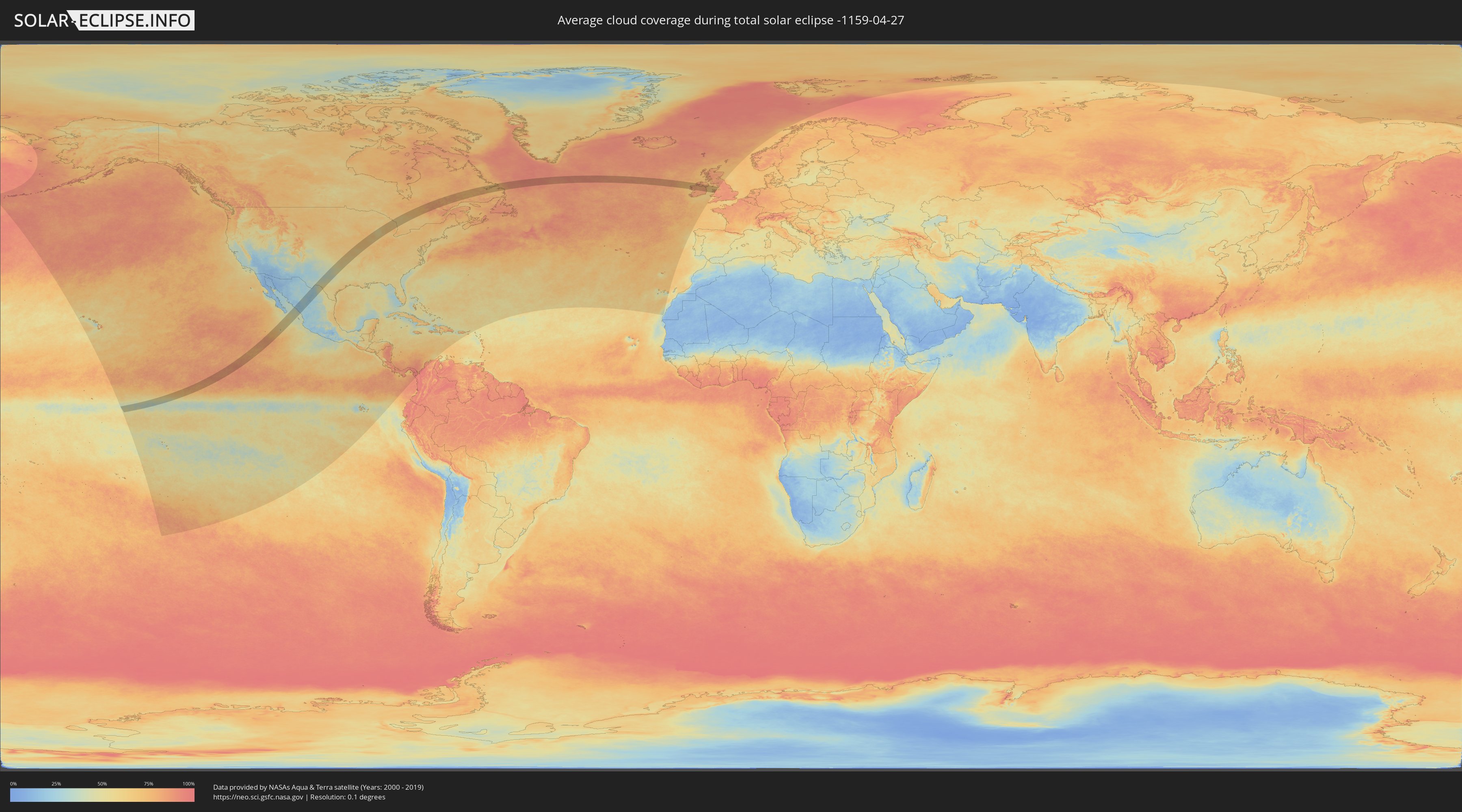
How will be the weather during the total solar eclipse on 04/27/-1159?
Where is the best place to see the total solar eclipse of 04/27/-1159?
The following maps show the average cloud coverage for the day of the total solar eclipse.
With the help of these maps, it is possible to find the place along the eclipse path, which has the best
chance of a cloudless sky.
Nevertheless, you should consider local circumstances and inform about the weather of your chosen
observation site.
The data is provided by NASAs satellites
AQUA and TERRA.
The cloud maps are averaged over a period of 19 years (2000 - 2019).
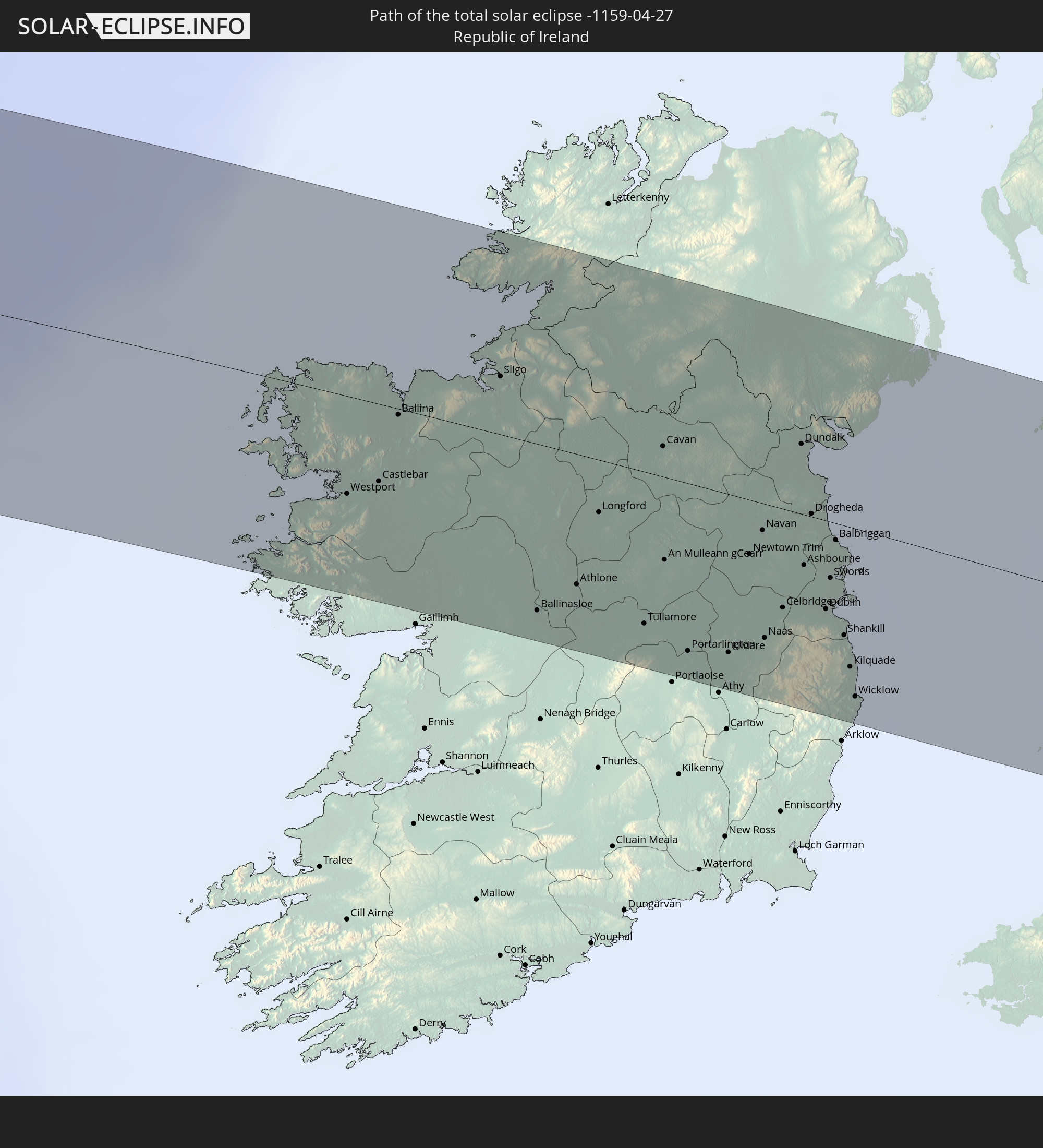
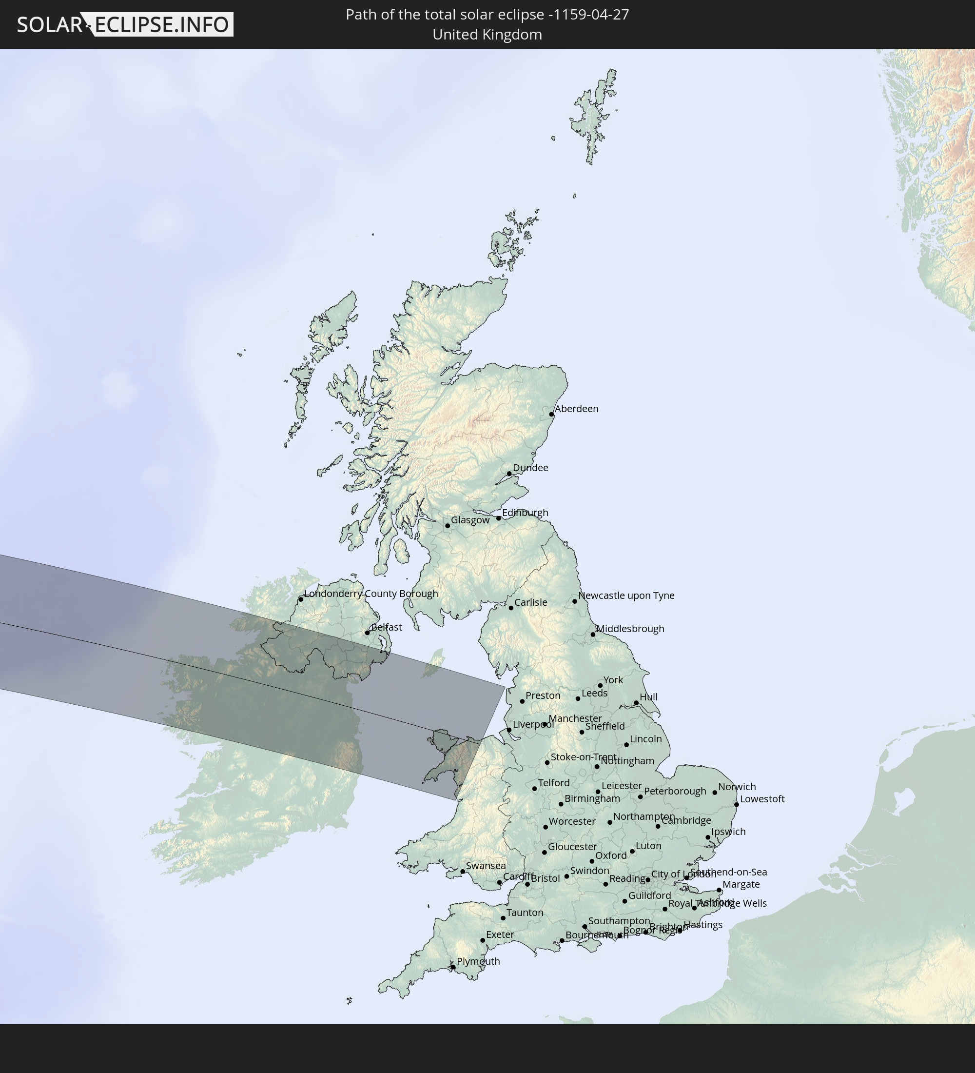
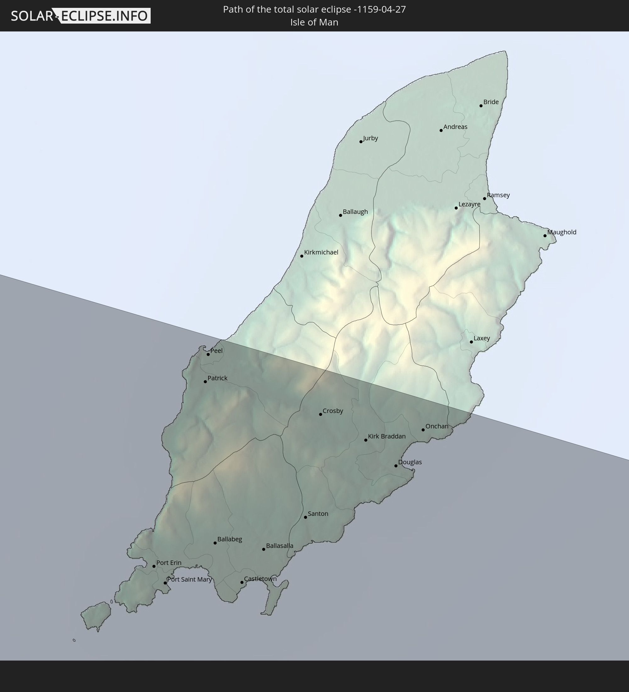
Detailed country maps
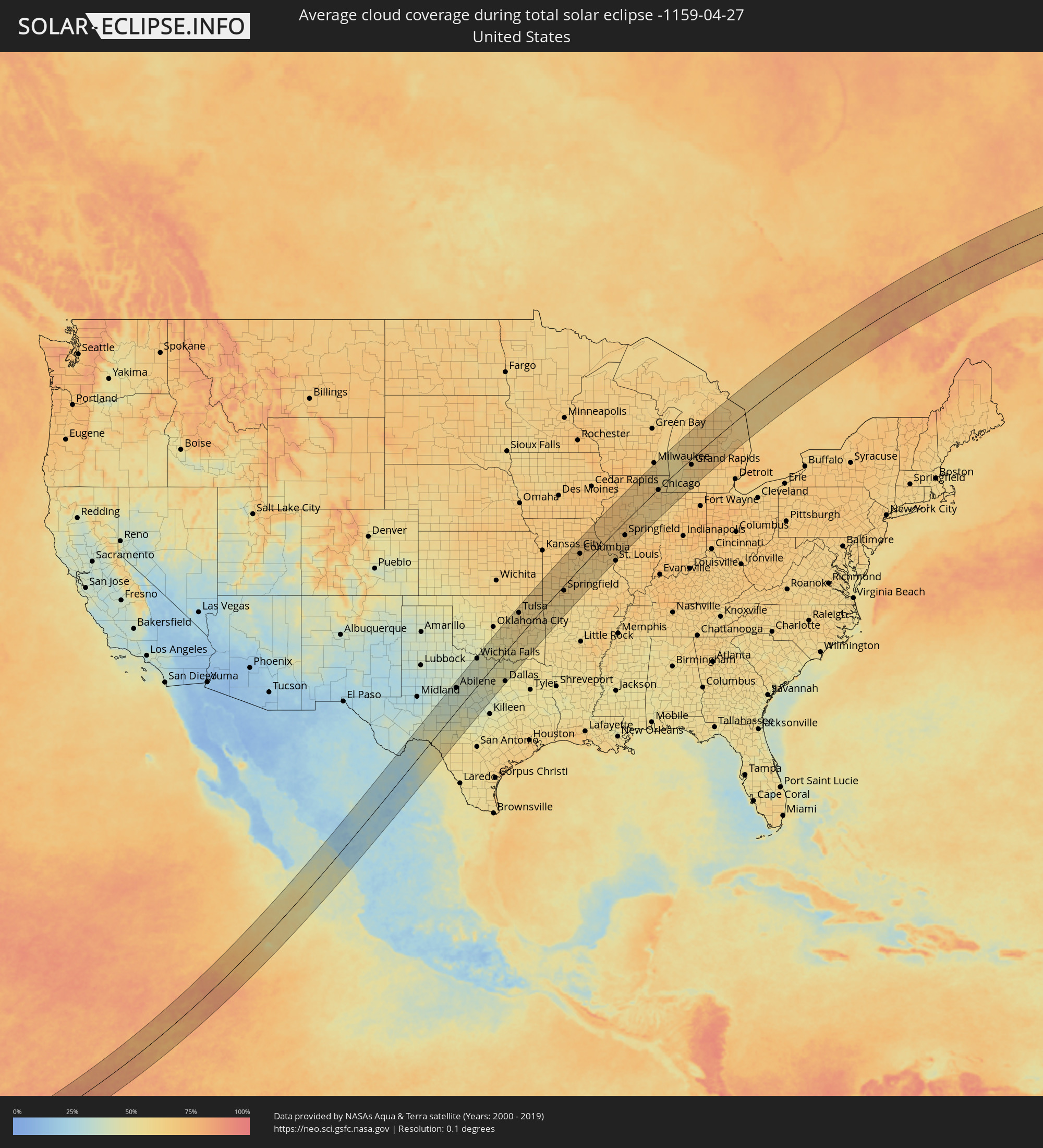 United States
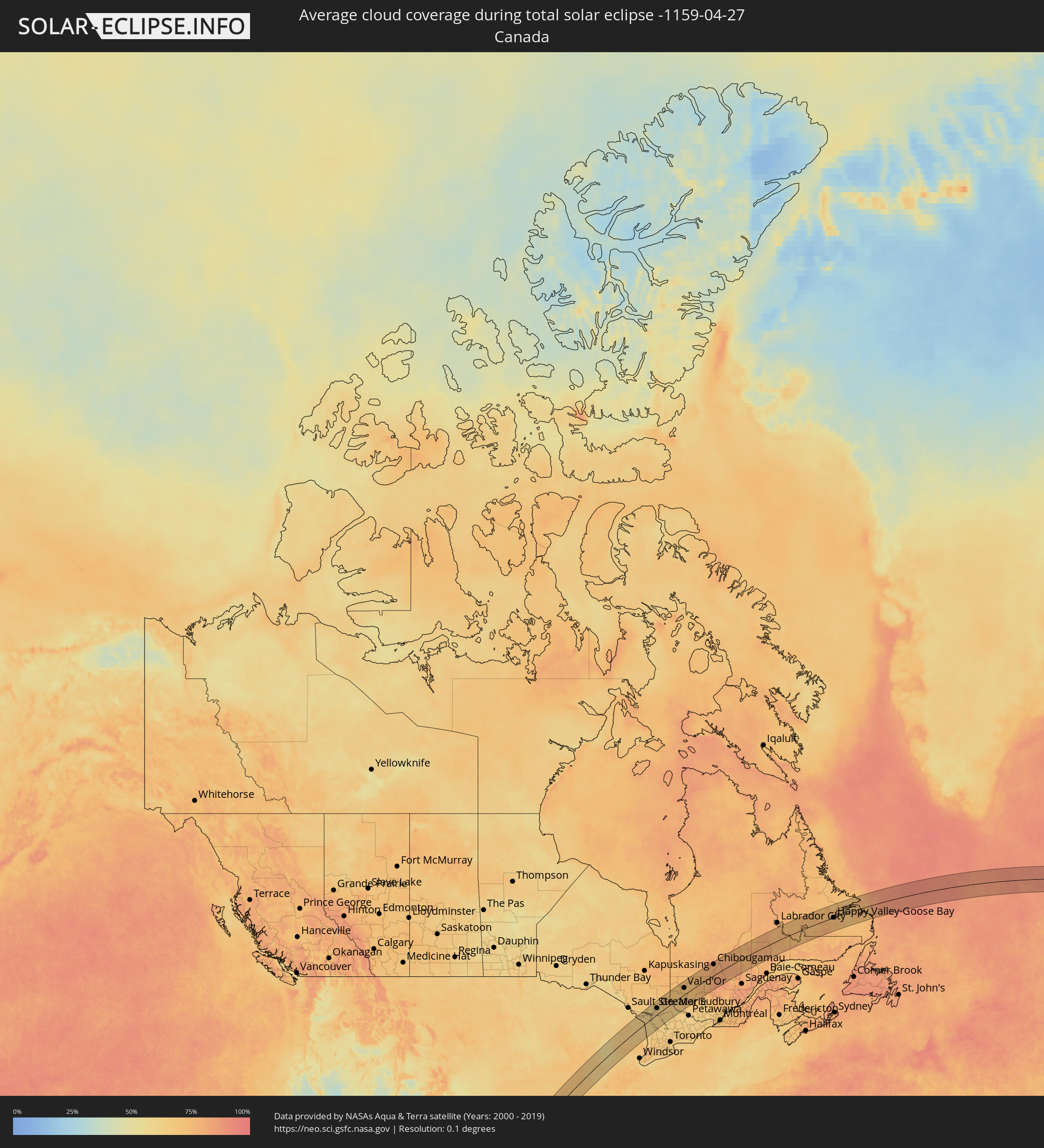 Canada
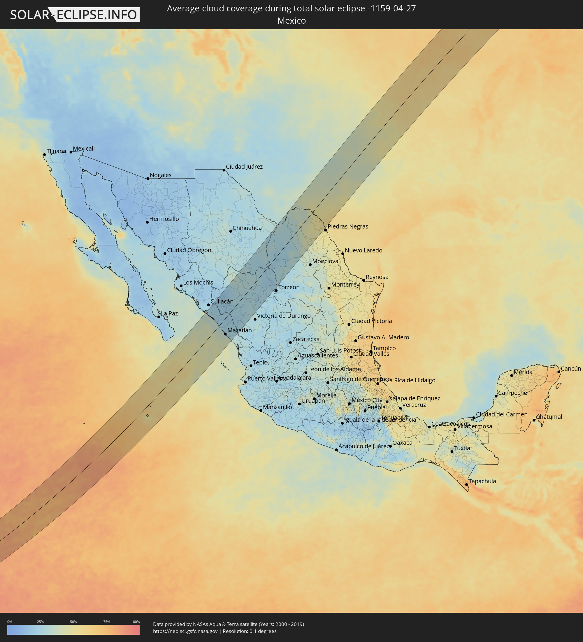 Mexico
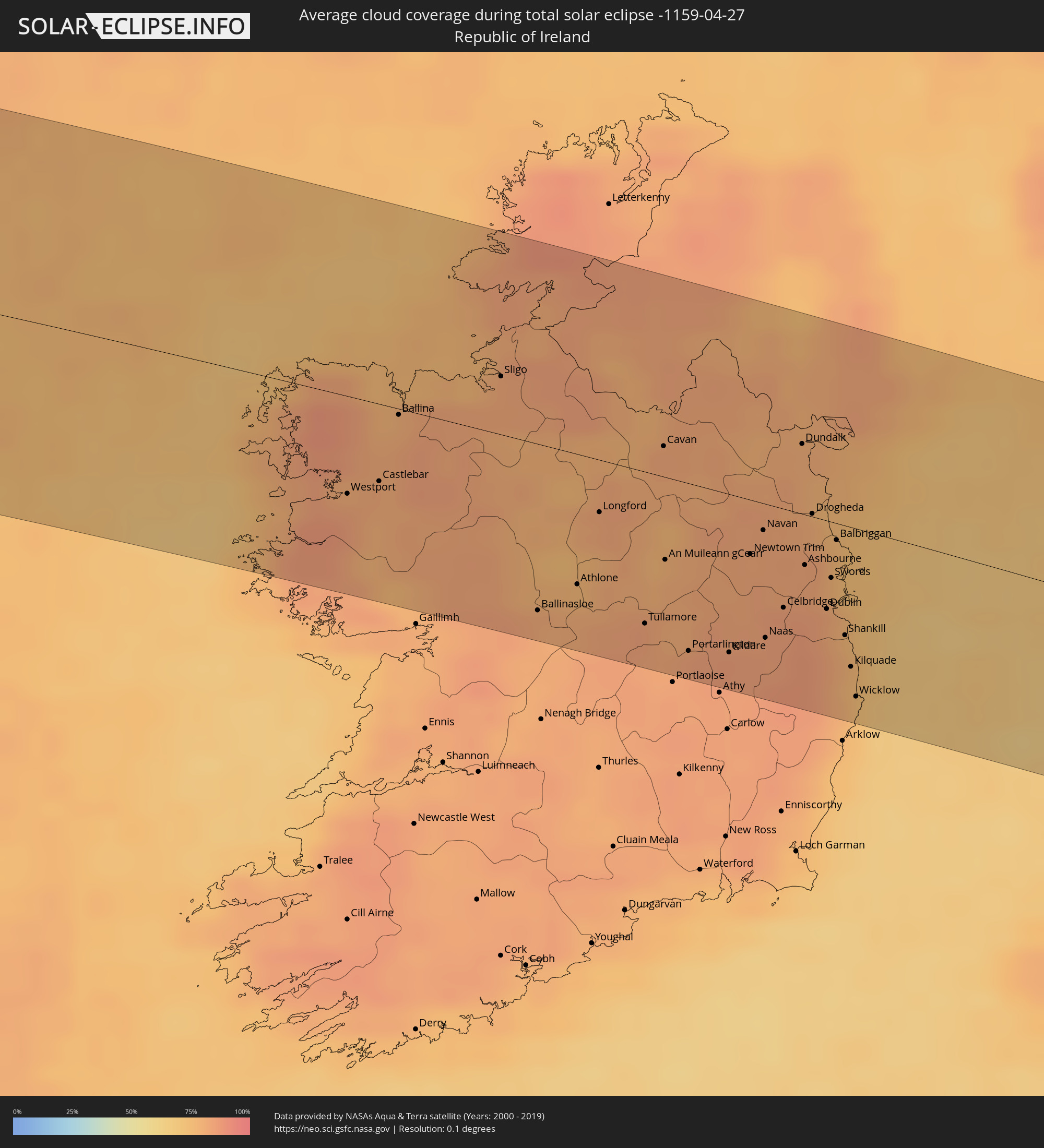 Republic of Ireland
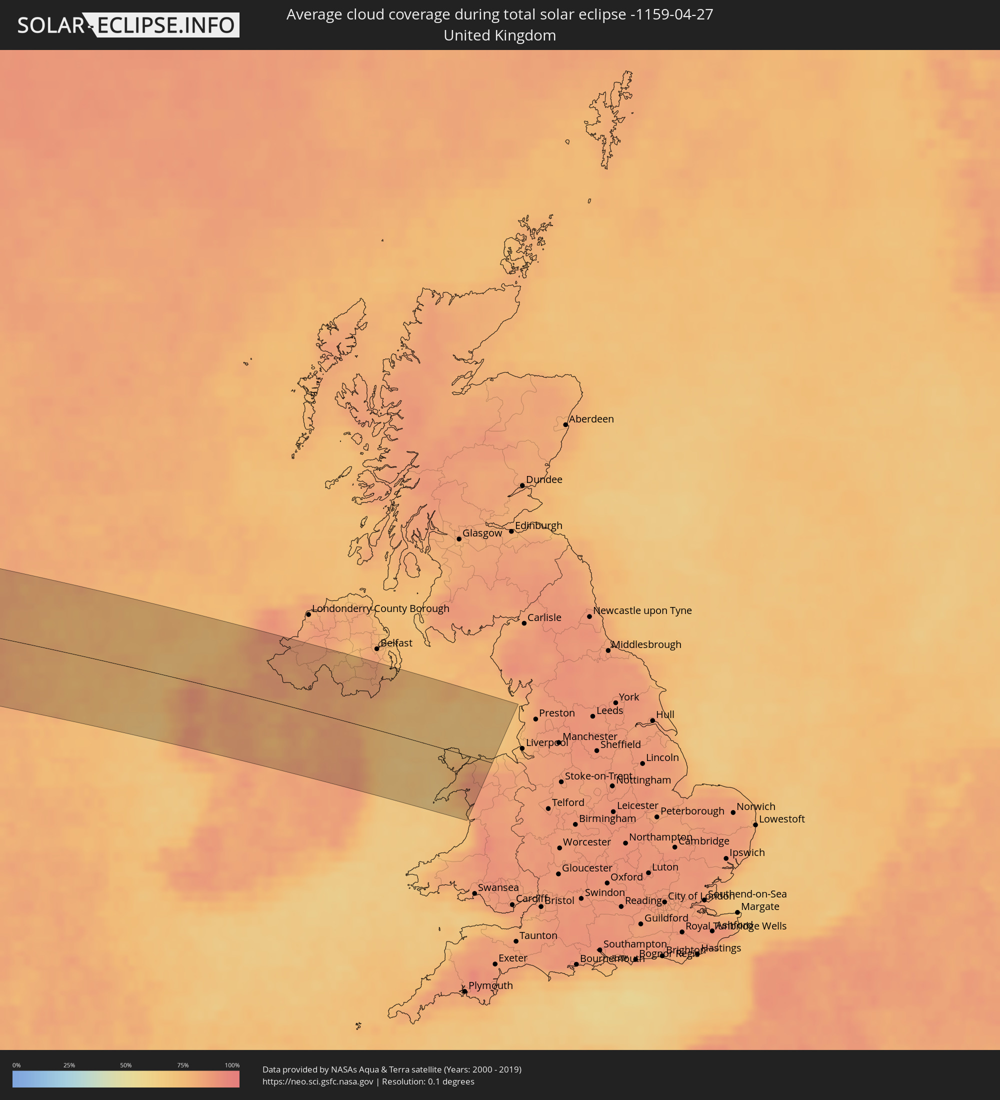 United Kingdom
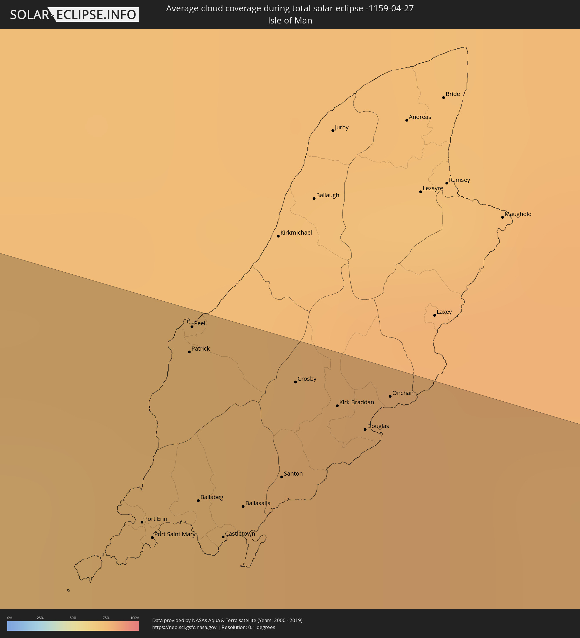 Isle of Man
Cities inside the path of the eclipse
The following table shows all locations with a population of more than 5,000 inside the eclipse path. Cities which have more than 100,000 inhabitants are marked bold. A click at the locations opens a detailed map.
| City | Type | Eclipse duration | Local time of max. eclipse | Distance to central line | Ø Cloud coverage |
|
Villa de Costa Rica, Sinaloa
|
total | - | 09:55:23 UTC-07:05 | 112 km | 25% |
|
Eldorado, Sinaloa
|
total | - | 09:54:53 UTC-07:05 | 91 km | 33% |
|
El Dorado, Sinaloa
|
total | - | 09:54:53 UTC-07:05 | 91 km | 33% |
|
Quila, Sinaloa
|
total | - | 09:55:16 UTC-07:05 | 87 km | 24% |
|
La Constancia, Sinaloa
|
total | - | 09:54:54 UTC-07:05 | 70 km | 30% |
|
El Rosario, Sinaloa
|
total | - | 09:54:59 UTC-07:05 | 72 km | 25% |
|
La Cruz, Sinaloa
|
total | - | 09:54:41 UTC-07:05 | 25 km | 29% |
|
Cosalá, Sinaloa
|
total | - | 09:55:56 UTC-07:05 | 45 km | 23% |
|
Mazatlán, Sinaloa
|
total | - | 09:53:55 UTC-07:05 | 62 km | 36% |
|
Fraccionamiento los Ángeles, Sinaloa
|
total | - | 09:53:55 UTC-07:05 | 71 km | 27% |
|
Villa Unión, Sinaloa
|
total | - | 09:54:04 UTC-07:05 | 80 km | 25% |
|
Concordia, Sinaloa
|
total | - | 09:54:28 UTC-07:05 | 85 km | 25% |
|
Tayoltita, Durango
|
total | - | 10:25:22 UTC-06:36 | 36 km | 21% |
|
Santiago Papasquiaro, Durango
|
total | - | 10:27:58 UTC-06:36 | 9 km | 28% |
|
Santa María del Oro, Durango
|
total | - | 10:29:52 UTC-06:36 | 52 km | 29% |
|
San Miguel de Papasquiaro, Durango
|
total | - | 10:27:38 UTC-06:36 | 30 km | 23% |
|
Nuevo Ideal, Durango
|
total | - | 10:28:06 UTC-06:36 | 47 km | 24% |
|
Canatlán, Durango
|
total | - | 10:27:47 UTC-06:36 | 96 km | 29% |
|
Bermejillo, Durango
|
total | - | 10:32:07 UTC-06:36 | 87 km | 22% |
|
Poanas, Durango
|
total | - | 10:31:54 UTC-06:36 | 97 km | 24% |
|
Tlahualilo de Zaragoza, Durango
|
total | - | 10:32:49 UTC-06:36 | 86 km | 24% |
|
Melchor Múzquiz, Coahuila
|
total | - | 10:39:06 UTC-06:36 | 107 km | 41% |
|
Ciudad Acuña, Coahuila
|
total | - | 10:42:48 UTC-06:36 | 47 km | 51% |
|
Zaragoza, Coahuila
|
total | - | 10:41:11 UTC-06:36 | 108 km | 48% |
|
San Angelo, Texas
|
total | - | 11:24:19 UTC-06:00 | 65 km | 36% |
|
Abilene, Texas
|
total | - | 11:27:14 UTC-06:00 | 83 km | 38% |
|
Wichita Falls, Texas
|
total | - | 11:31:47 UTC-06:00 | 97 km | 41% |
|
Fort Worth, Texas
|
total | - | 11:31:19 UTC-06:00 | 72 km | 49% |
|
Denton, Texas
|
total | - | 11:32:31 UTC-06:00 | 50 km | 50% |
|
Arlington, Texas
|
total | - | 11:31:39 UTC-06:00 | 86 km | 48% |
|
Carrollton, Texas
|
total | - | 11:32:23 UTC-06:00 | 86 km | 51% |
|
Frisco, Texas
|
total | - | 11:32:51 UTC-06:00 | 77 km | 49% |
|
Dallas, Texas
|
total | - | 11:32:12 UTC-06:00 | 104 km | 51% |
|
Plano, Texas
|
total | - | 11:32:48 UTC-06:00 | 95 km | 48% |
|
McKinney, Texas
|
total | - | 11:33:15 UTC-06:00 | 88 km | 50% |
|
Tulsa, Oklahoma
|
total | - | 11:39:30 UTC-06:00 | 83 km | 60% |
|
Broken Arrow, Oklahoma
|
total | - | 11:39:37 UTC-06:00 | 62 km | 62% |
|
Fort Smith, Arkansas
|
total | - | 11:40:33 UTC-06:00 | 81 km | 58% |
|
Springfield, Missouri
|
total | - | 11:45:20 UTC-06:00 | 18 km | 66% |
|
Columbia, Missouri
|
total | - | 11:49:35 UTC-06:00 | 51 km | 68% |
|
O'Fallon, Missouri
|
total | - | 11:51:49 UTC-06:00 | 62 km | 64% |
|
Springfield, Illinois
|
total | - | 11:54:54 UTC-06:00 | 50 km | 69% |
|
Peoria, Illinois
|
total | - | 11:56:16 UTC-06:00 | 17 km | 68% |
|
Bloomington, Illinois
|
total | - | 11:56:51 UTC-06:00 | 35 km | 68% |
|
Decatur, Illinois
|
total | - | 11:56:00 UTC-06:00 | 88 km | 66% |
|
Aurora, Illinois
|
total | - | 11:59:36 UTC-06:00 | 28 km | 69% |
|
Elgin, Illinois
|
total | - | 12:00:02 UTC-06:00 | 48 km | 67% |
|
Joliet, Illinois
|
total | - | 11:59:38 UTC-06:00 | 5 km | 66% |
|
Arlington Heights, Illinois
|
total | - | 12:00:32 UTC-06:00 | 35 km | 69% |
|
Waukegan, Illinois
|
total | - | 12:01:06 UTC-06:00 | 49 km | 62% |
|
Kenosha, Wisconsin
|
total | - | 12:01:25 UTC-06:00 | 66 km | 61% |
|
Racine, Wisconsin
|
total | - | 12:01:39 UTC-06:00 | 75 km | 61% |
|
Evanston, Illinois
|
total | - | 12:00:54 UTC-06:00 | 14 km | 65% |
|
Chicago, Illinois
|
total | - | 12:00:43 UTC-06:00 | 3 km | 65% |
|
Hammond, Indiana
|
total | - | 12:00:35 UTC-06:00 | 33 km | 65% |
|
South Bend, Indiana
|
total | - | 13:02:34 UTC-05:00 | 96 km | 63% |
|
Grand Rapids, Michigan
|
total | - | 13:05:01 UTC-05:00 | 22 km | 64% |
|
Lansing, Michigan
|
total | - | 13:06:22 UTC-05:00 | 101 km | 65% |
|
Rayside-Balfour, Ontario
|
total | - | 13:15:05 UTC-05:00 | 65 km | 61% |
|
Greater Sudbury, Ontario
|
total | - | 13:15:16 UTC-05:00 | 45 km | 61% |
|
Parry Sound, Ontario
|
total | - | 13:15:35 UTC-05:00 | 101 km | 62% |
|
Temiskaming Shores, Ontario
|
total | - | 13:17:49 UTC-05:00 | 76 km | 72% |
|
North Bay, Ontario
|
total | - | 13:17:12 UTC-05:00 | 41 km | 64% |
|
Val-d'Or, Quebec
|
total | - | 13:20:46 UTC-05:00 | 47 km | 71% |
|
Chibougamau, Quebec
|
total | - | 13:26:08 UTC-05:00 | 80 km | 82% |
|
Dolbeau-Mistassini, Quebec
|
total | - | 13:28:17 UTC-05:00 | 99 km | 73% |
|
Happy Valley-Goose Bay, Newfoundland and Labrador
|
total | - | 14:27:32 UTC-04:14 | 1 km | 76% |
|
Castlebar, Connaught
|
total | - | 18:39:10 UTC-00:25 | 33 km | 81% |
|
Ballina, Connaught
|
total | - | 18:38:56 UTC-00:25 | 3 km | 80% |
|
Sligo, Connaught
|
total | - | 18:38:45 UTC-00:25 | 25 km | 80% |
|
Ballinasloe, Connaught
|
total | - | 18:39:34 UTC-00:25 | 73 km | 81% |
|
Athlone, Leinster
|
total | - | 18:39:27 UTC-00:25 | 57 km | 80% |
|
Longford, Leinster
|
total | - | 18:39:11 UTC-00:25 | 23 km | 81% |
|
Enniskillen, Northern Ireland
|
total | - | 19:03:58 UTC+00:00 | 47 km | 79% |
|
Tullamore, Leinster
|
total | - | 18:39:33 UTC-00:25 | 66 km | 84% |
|
Dromore, Northern Ireland
|
total | - | 19:03:48 UTC+00:00 | 68 km | 82% |
|
Cavan, Ulster
|
total | - | 18:38:55 UTC-00:25 | 13 km | 82% |
|
An Muileann gCearr, Leinster
|
total | - | 18:39:19 UTC-00:25 | 36 km | 79% |
|
Omagh, Northern Ireland
|
total | - | 19:03:42 UTC+00:00 | 80 km | 83% |
|
Portarlington, Leinster
|
total | - | 18:39:38 UTC-00:25 | 73 km | 83% |
|
Cherryville, Leinster
|
total | - | 18:39:37 UTC-00:25 | 70 km | 85% |
|
Kildare, Leinster
|
total | - | 18:39:36 UTC-00:25 | 69 km | 85% |
|
Newtown Trim, Leinster
|
total | - | 18:39:14 UTC-00:25 | 24 km | 82% |
|
Dungannon, Northern Ireland
|
total | - | 19:03:45 UTC+00:00 | 78 km | 78% |
|
Coalisland, Northern Ireland
|
total | - | 19:03:42 UTC+00:00 | 84 km | 79% |
|
Clane, Leinster
|
total | - | 18:39:28 UTC-00:25 | 51 km | 83% |
|
Navan, Leinster
|
total | - | 18:39:09 UTC-00:25 | 12 km | 83% |
|
Naas, Leinster
|
total | - | 18:39:32 UTC-00:25 | 58 km | 84% |
|
Armagh, Northern Ireland
|
total | - | 19:03:52 UTC+00:00 | 64 km | 80% |
|
Celbridge, Leinster
|
total | - | 18:39:25 UTC-00:25 | 43 km | 85% |
|
Dunboyne, Leinster
|
total | - | 18:39:21 UTC-00:25 | 35 km | 85% |
|
Portadown, Northern Ireland
|
total | - | 19:03:47 UTC+00:00 | 75 km | 78% |
|
Dundalk, Leinster
|
total | - | 18:38:49 UTC-00:25 | 30 km | 80% |
|
Ashbourne, Leinster
|
total | - | 18:39:15 UTC-00:25 | 22 km | 83% |
|
Craigavon, Northern Ireland
|
total | - | 19:03:45 UTC+00:00 | 79 km | 78% |
|
Drogheda, Leinster
|
total | - | 18:39:03 UTC-00:25 | 1 km | 79% |
|
Firhouse, Leinster
|
total | - | 18:39:26 UTC-00:25 | 46 km | 84% |
|
Newry, Northern Ireland
|
total | - | 19:04:00 UTC+00:00 | 51 km | 80% |
|
Templeogue, Leinster
|
total | - | 18:39:25 UTC-00:25 | 44 km | 84% |
|
Greenhills, Leinster
|
total | - | 18:39:23 UTC-00:25 | 39 km | 84% |
|
Banbridge, Northern Ireland
|
total | - | 19:03:50 UTC+00:00 | 70 km | 80% |
|
Ballymun, Leinster
|
total | - | 18:39:20 UTC-00:25 | 32 km | 84% |
|
Warrenpoint, Northern Ireland
|
total | - | 18:38:42 UTC-00:25 | 44 km | 79% |
|
Dublin, Leinster
|
total | - | 18:39:23 UTC-00:25 | 38 km | 80% |
|
Booterstown
|
total | - | 18:39:24 UTC-00:25 | 41 km | 80% |
|
Balbriggan, Leinster
|
total | - | 18:39:08 UTC-00:25 | 7 km | 78% |
|
Lusk, Leinster
|
total | - | 18:39:12 UTC-00:25 | 16 km | 78% |
|
Donabate, Leinster
|
total | - | 18:39:14 UTC-00:25 | 20 km | 78% |
|
Sallynoggin, Leinster
|
total | - | 18:39:25 UTC-00:25 | 42 km | 77% |
|
Dalkey, Leinster
|
total | - | 18:39:25 UTC-00:25 | 42 km | 77% |
|
Bray, Leinster
|
total | - | 18:39:29 UTC-00:25 | 50 km | 78% |
|
Kilquade
|
total | - | 18:39:34 UTC-00:25 | 61 km | 77% |
|
Kilkeel, Northern Ireland
|
total | - | 19:04:04 UTC+00:00 | 44 km | 79% |
|
Ballynahinch, Northern Ireland
|
total | - | 19:03:45 UTC+00:00 | 82 km | 82% |
|
Newcastle, Northern Ireland
|
total | - | 19:03:55 UTC+00:00 | 63 km | 81% |
|
Downpatrick, Northern Ireland
|
total | - | 19:03:47 UTC+00:00 | 78 km | 79% |
|
Port Erin, Port Erin
|
total | - | 19:03:53 UTC+00:00 | 69 km | 72% |
|
Port Saint Mary, Port St Mary
|
total | - | 19:03:54 UTC+00:00 | 68 km | 74% |
|
Patrick, Patrick
|
total | - | 19:03:47 UTC+00:00 | 83 km | 74% |
|
Peel, Peel
|
total | - | 19:03:46 UTC+00:00 | 85 km | 74% |
|
Ballabeg, Arbory
|
total | - | 19:03:52 UTC+00:00 | 72 km | 74% |
|
Castletown, Castletown
|
total | - | 19:03:53 UTC+00:00 | 69 km | 74% |
|
Holyhead, Wales
|
total | - | 19:04:34 UTC+00:00 | 12 km | 69% |
|
Ballasalla, Malew
|
total | - | 19:03:52 UTC+00:00 | 72 km | 75% |
|
Santon, Santon
|
total | - | 19:03:50 UTC+00:00 | 75 km | 75% |
|
Crosby, Marown
|
total | - | 19:03:47 UTC+00:00 | 83 km | 75% |
|
Kirk Braddan, Braddan
|
total | - | 19:03:47 UTC+00:00 | 82 km | 77% |
|
Douglas, Douglas
|
total | - | 19:03:48 UTC+00:00 | 81 km | 77% |
|
Onchan, Onchan
|
total | - | 19:03:46 UTC+00:00 | 84 km | 77% |
|
Caernarfon, Wales
|
total | - | 19:04:39 UTC+00:00 | 23 km | 79% |
|
Bangor, Wales
|
total | - | 19:04:33 UTC+00:00 | 11 km | 84% |
|
Llandudno, Wales
|
total | - | 19:04:26 UTC+00:00 | 5 km | 79% |
|
Deganwy, Wales
|
total | - | 19:04:27 UTC+00:00 | 2 km | 79% |
|
Colwyn Bay, Wales
|
total | - | 19:04:26 UTC+00:00 | 3 km | 78% |
|
Abergele, Wales
|
total | - | 19:04:26 UTC+00:00 | 5 km | 78% |