Totale Sonnenfinsternis vom 01.03.-1417
| Wochentag: | Donnerstag |
| Maximale Dauer der Verfinsterung: | 04m12s |
| Maximale Breite des Finsternispfades: | 196 km |
| Saroszyklus: | 17 |
| Bedeckungsgrad: | 100% |
| Magnitude: | 1.0546 |
| Gamma: | -0.4023 |
Wo kann man die Sonnenfinsternis vom 01.03.-1417 sehen?
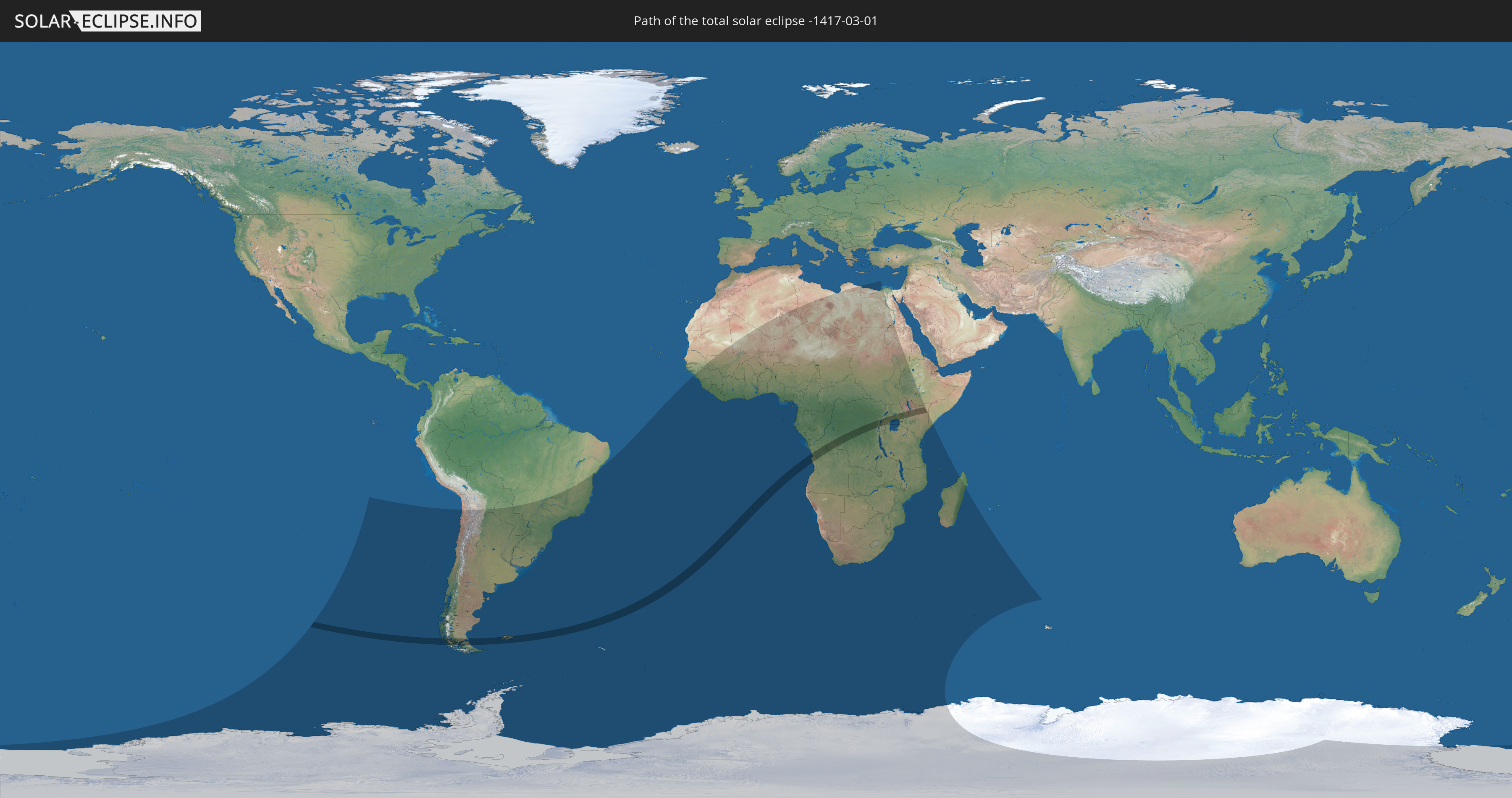
Die Sonnenfinsternis am 01.03.-1417 kann man in 58 Ländern als partielle Sonnenfinsternis beobachten.
Der Finsternispfad verläuft durch 9 Länder. Nur in diesen Ländern ist sie als totale Sonnenfinsternis zu sehen.
In den folgenden Ländern ist die Sonnenfinsternis total zu sehen
 Chile
Chile
 Argentinien
 Falklandinseln
 Angola
 Demokratische Republik Kongo
 Ruanda
 Tansania
 Uganda
 Kenia
Kenia
In den folgenden Ländern ist die Sonnenfinsternis partiell zu sehen
 Antarktika
 Chile
Chile
 Brasilien
 Argentinien
 Bolivien
 Paraguay
 Falklandinseln
 Uruguay
 Südgeorgien und die Südlichen Sandwichinseln
 Senegal
 Mauretanien
 Guinea
 St. Helena
 Sierra Leone
 Mali
Mali
 Liberia
 Algerien
 Elfenbeinküste
 Burkina Faso
 Ghana
Ghana
 Togo
Togo
 Niger
Niger
 Benin
Benin
 Nigeria
 Bouvetinsel
 Äquatorialguinea
 São Tomé und Príncipe
 Kamerun
 Gabun
Gabun
 Libyen
 Republik Kongo
 Angola
 Namibia
 Demokratische Republik Kongo
 Tschad
 Zentralafrikanische Republik
 Südafrika
 Botswana
 Sudan
Sudan
 Sambia
 Ägypten
 Simbabwe
 Lesotho
 Ruanda
 Burundi
 Tansania
 Uganda
 Mosambik
 Swasiland
 Malawi
 Äthiopien
 Kenia
Kenia
 Französische Süd- und Antarktisgebiete
 Somalia
 Madagaskar
 Komoren
 Mayotte
 Seychellen
Wie wird das Wetter während der totalen Sonnenfinsternis am 01.03.-1417?
Wo ist der beste Ort, um die totale Sonnenfinsternis vom 01.03.-1417 zu beobachten?
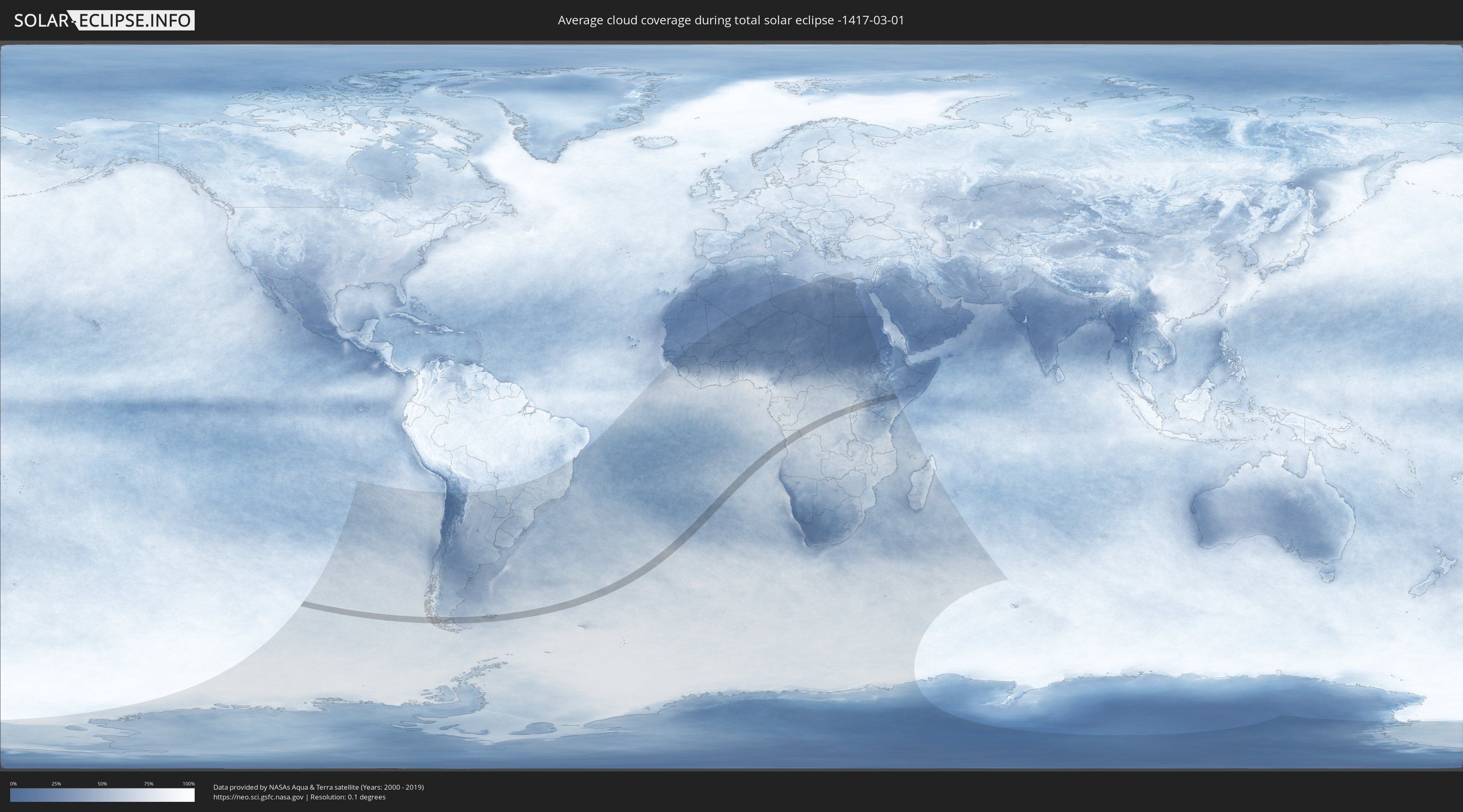
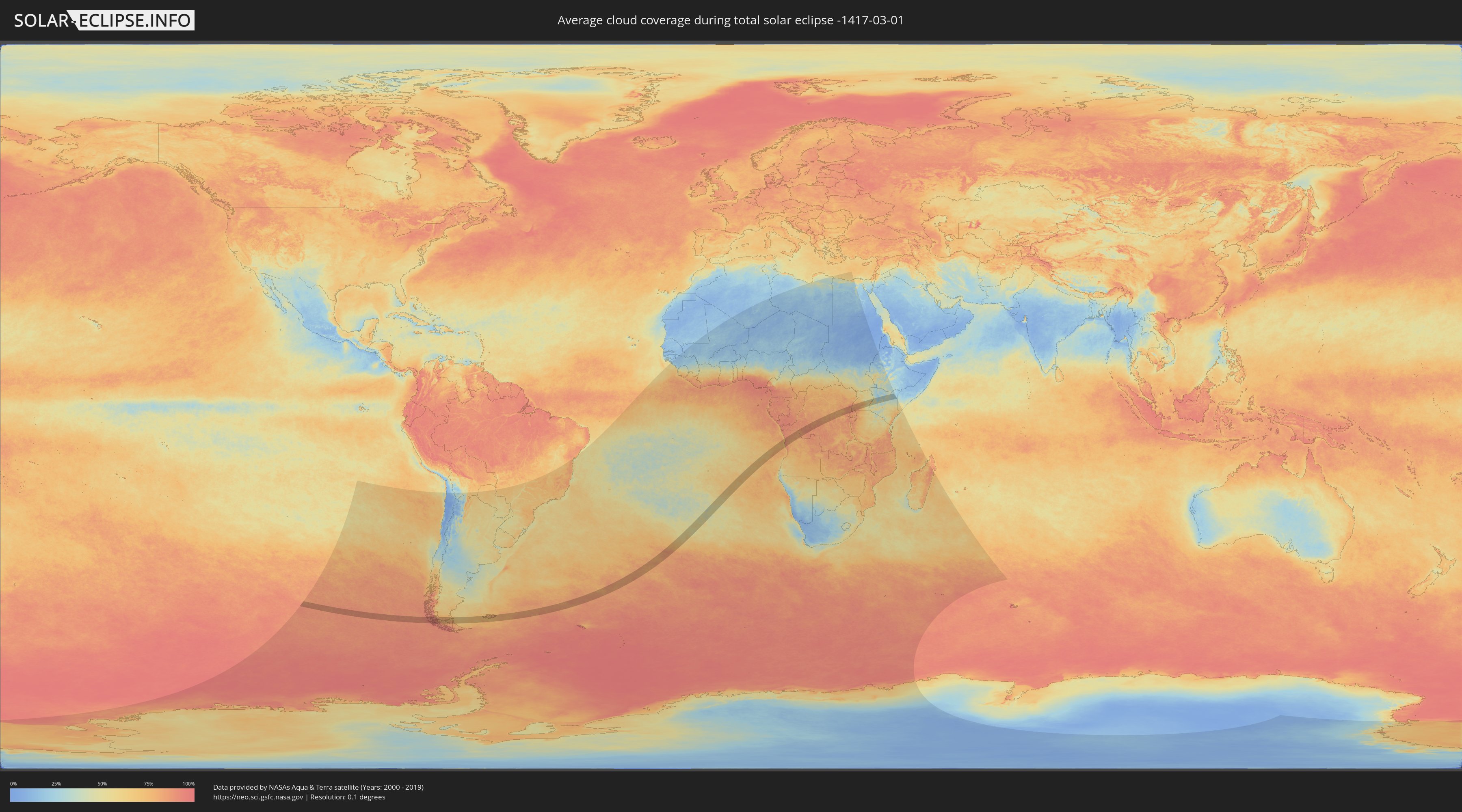
Die folgenden Karten zeigen die durchschnittliche Bewölkung für den Tag, an dem die totale Sonnenfinsternis
stattfindet. Mit Hilfe der Karten lässt sich der Ort entlang des Finsternispfades eingrenzen,
der die besten Aussichen auf einen klaren wolkenfreien Himmel bietet.
Trotzdem muss man immer lokale Gegenenheiten beachten und sollte sich genau über das Wetter an seinem
gewählten Beobachtungsort informieren.
Die Daten stammen von den beiden NASA-Satelliten
AQUA und TERRA
und wurden über einen Zeitraum von 19 Jahren (2000 - 2019) gemittelt.
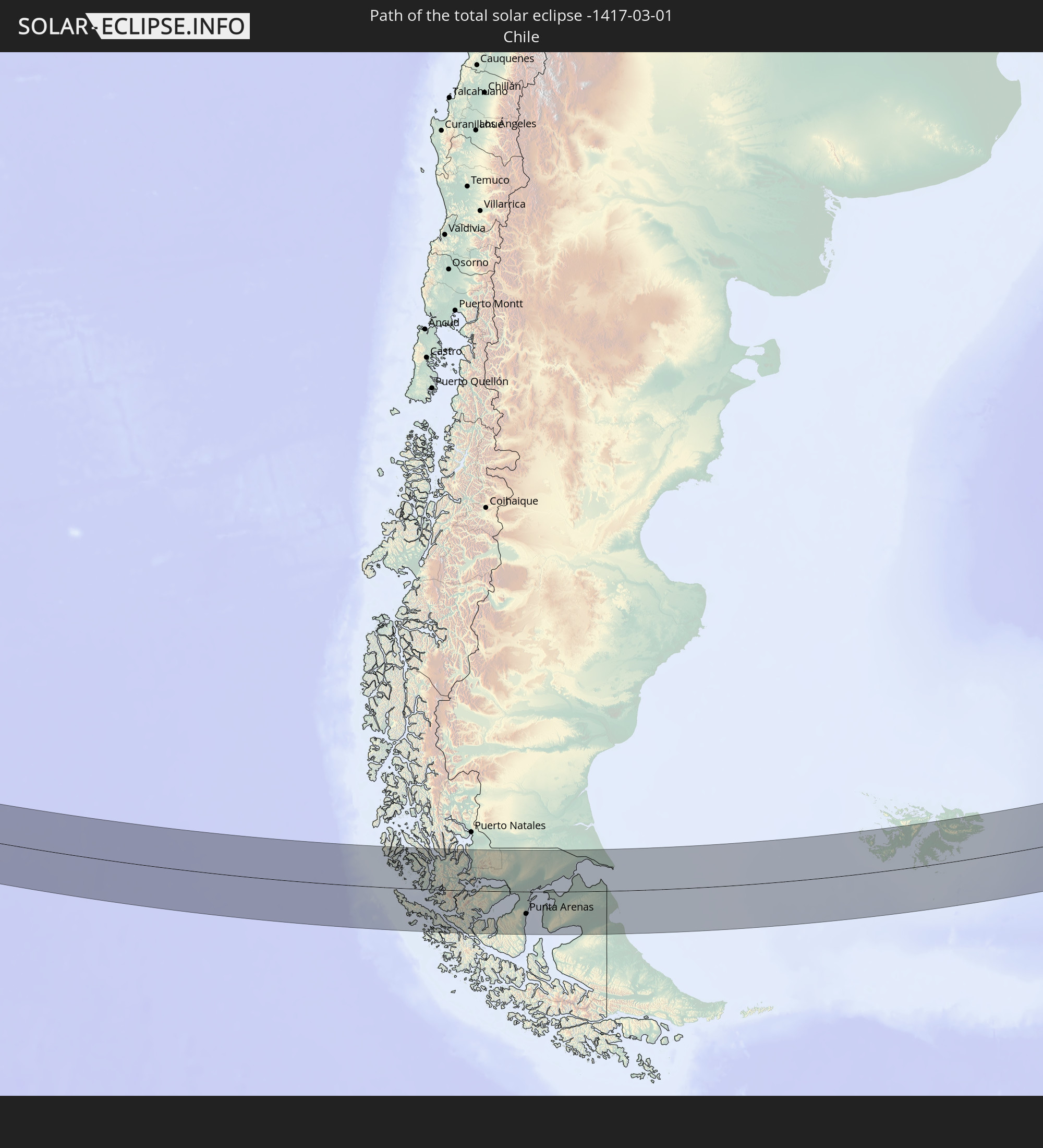
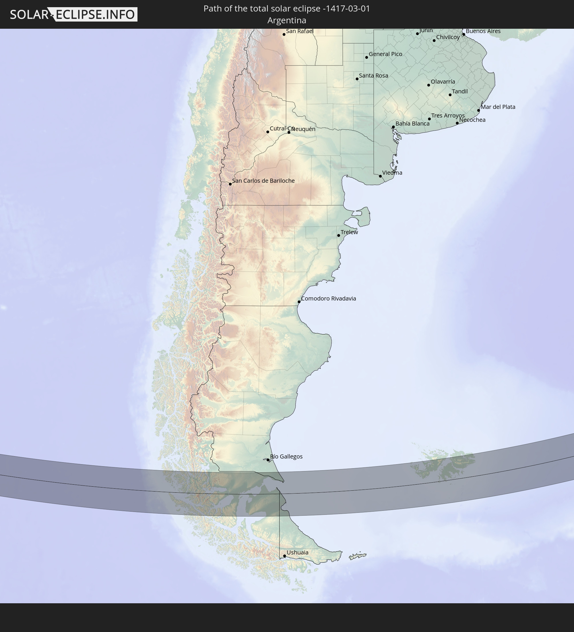
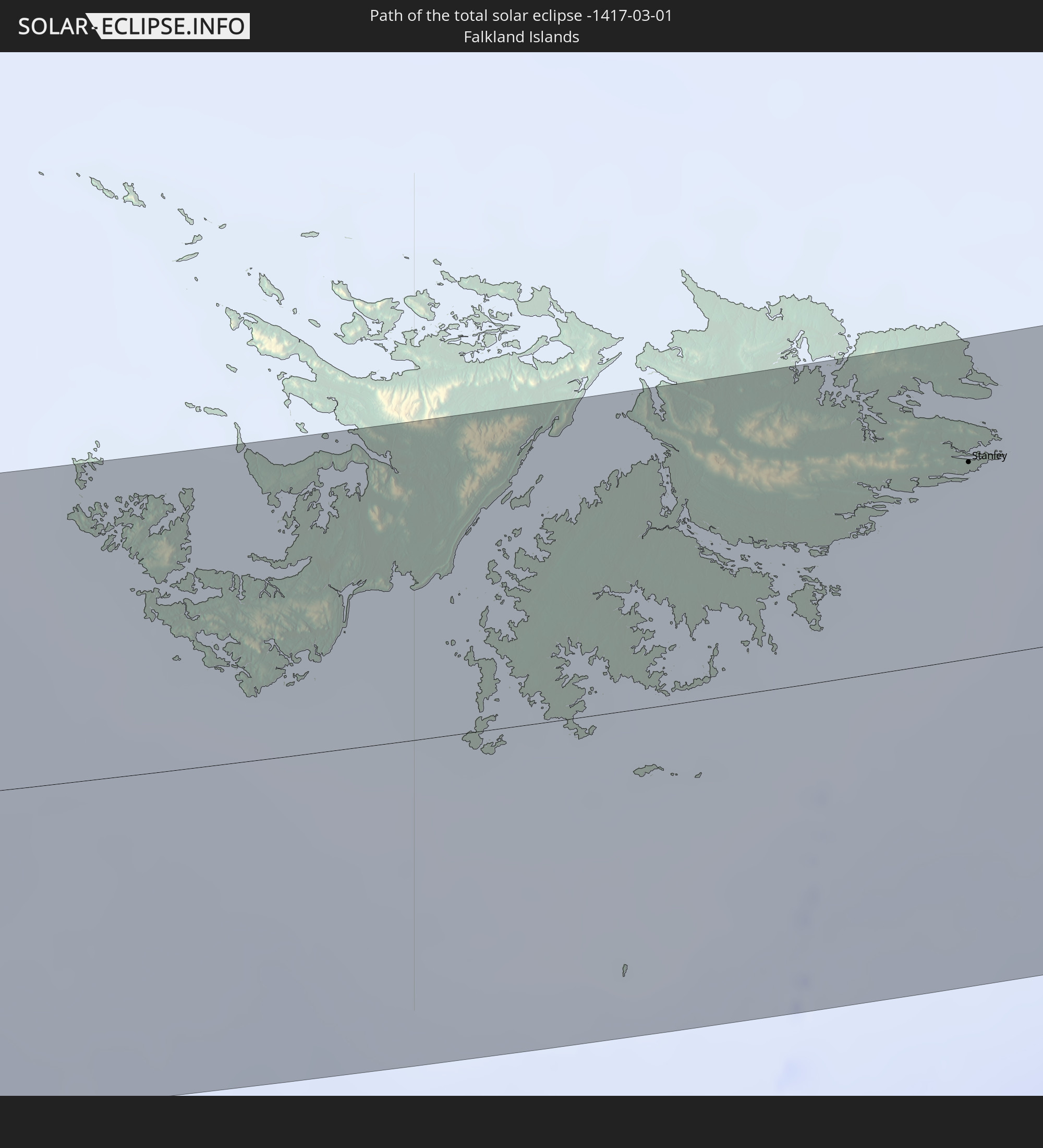
Detaillierte Länderkarten
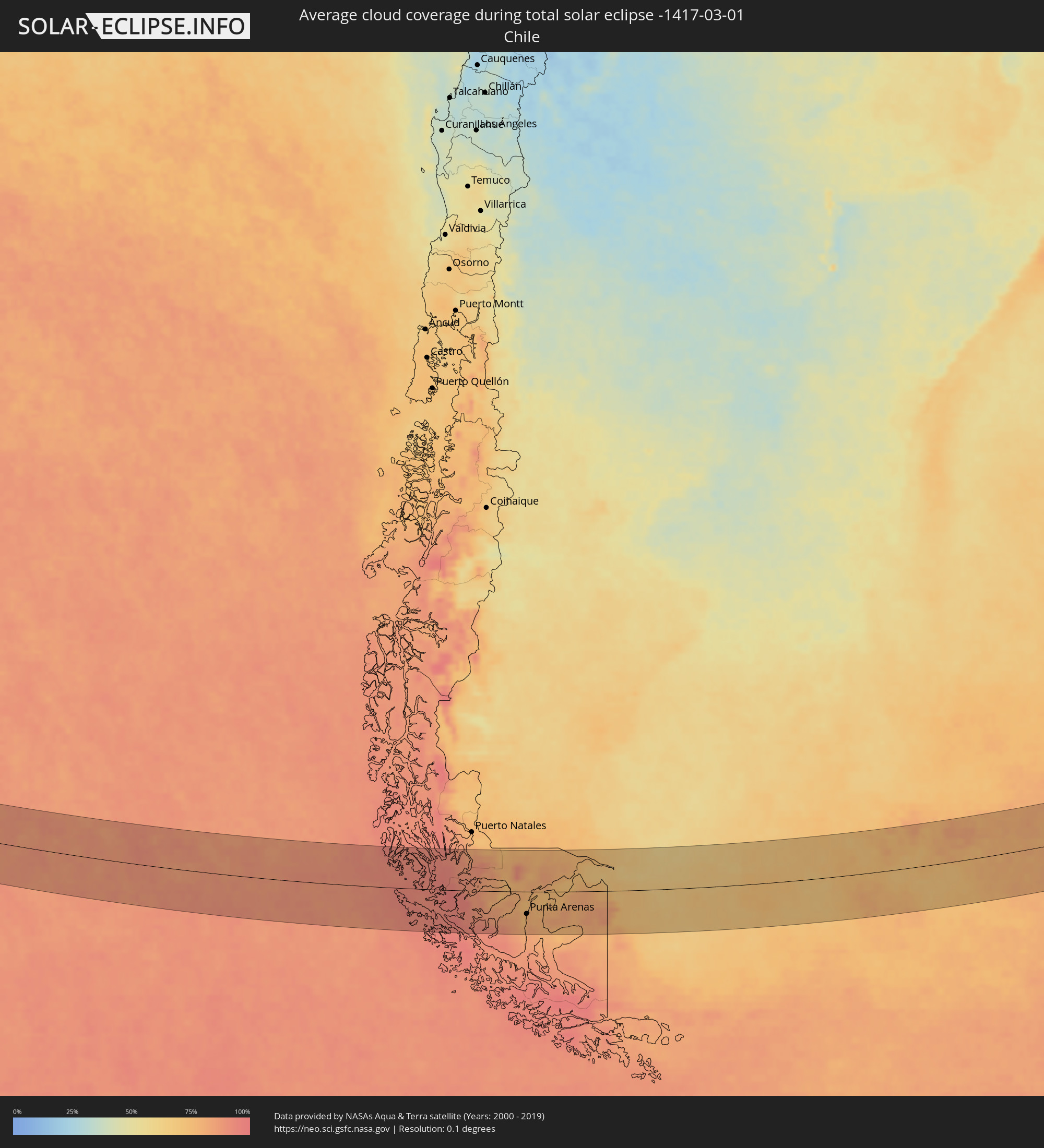 Chile
Chile
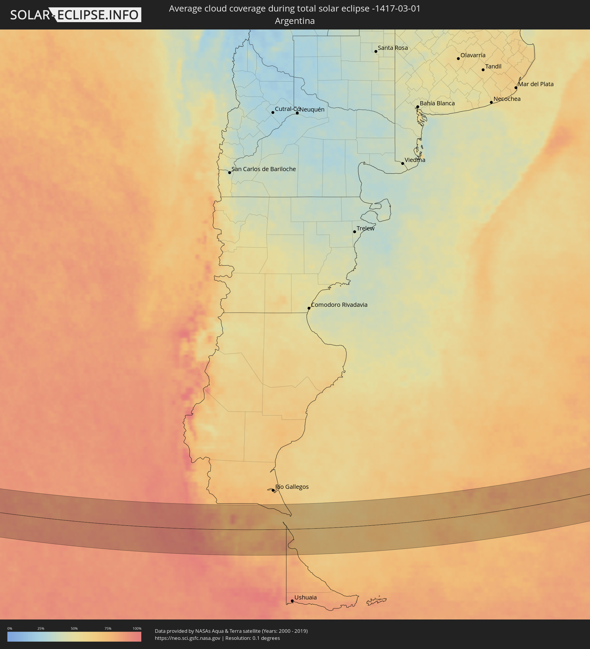 Argentinien
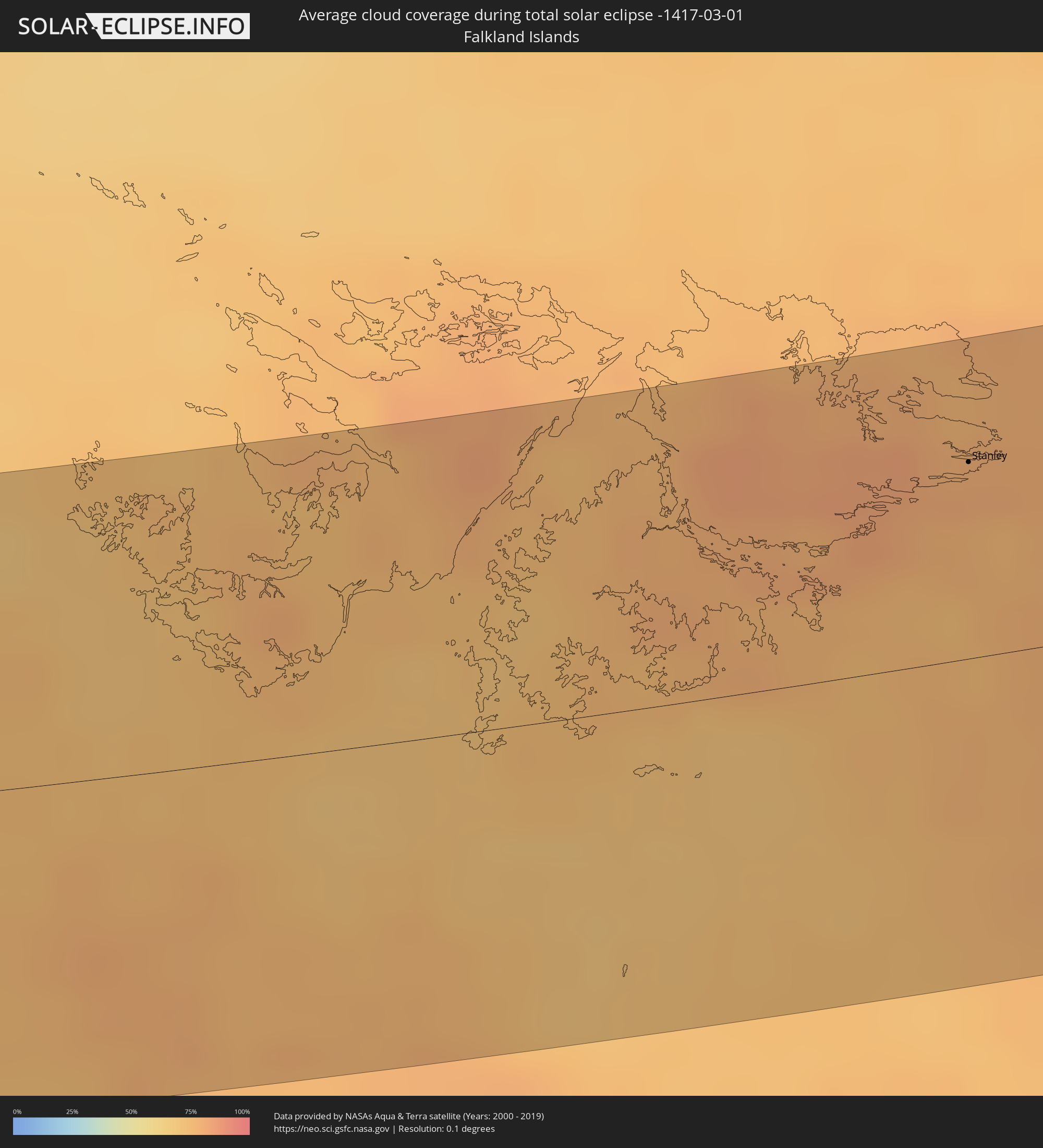 Falklandinseln
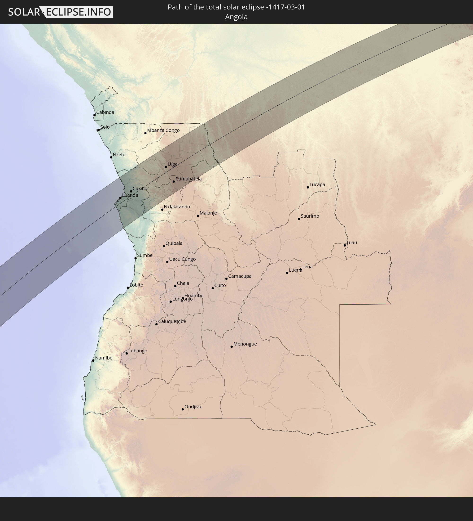
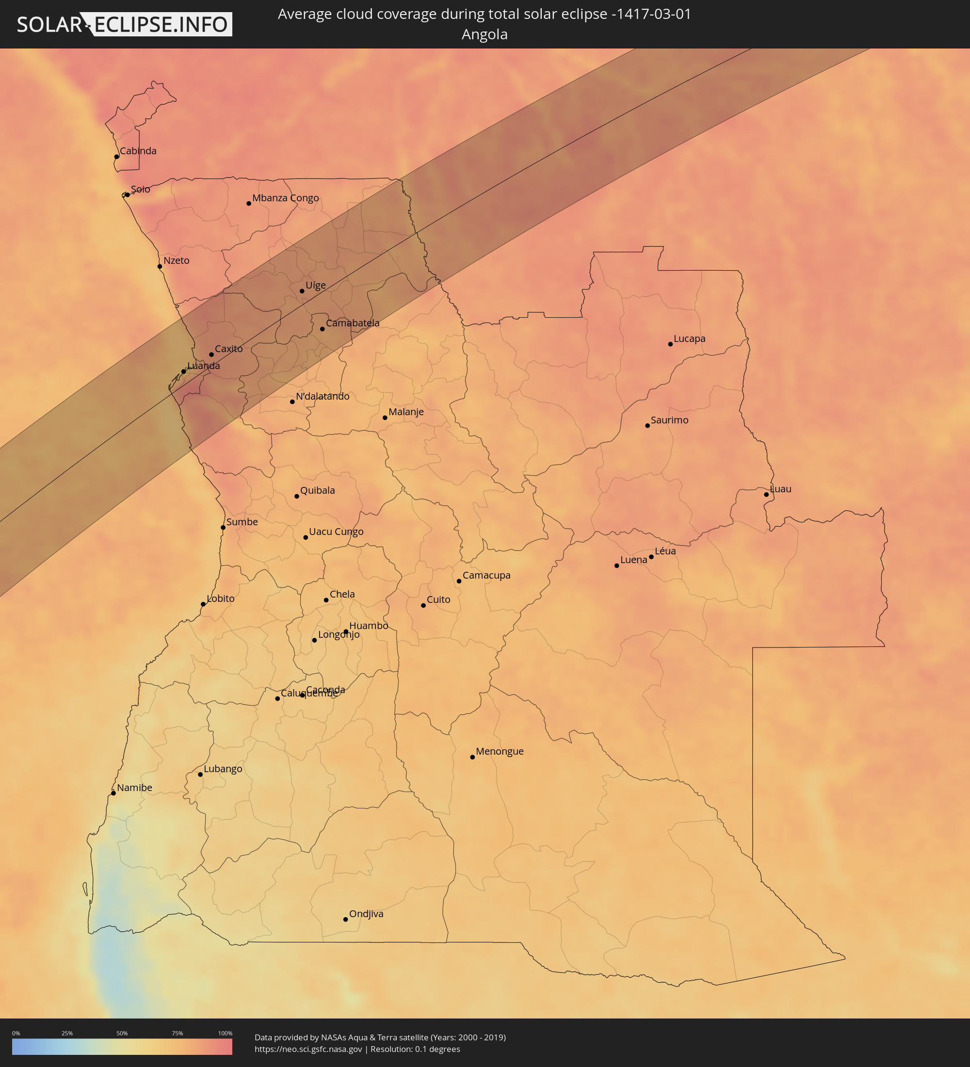 Angola
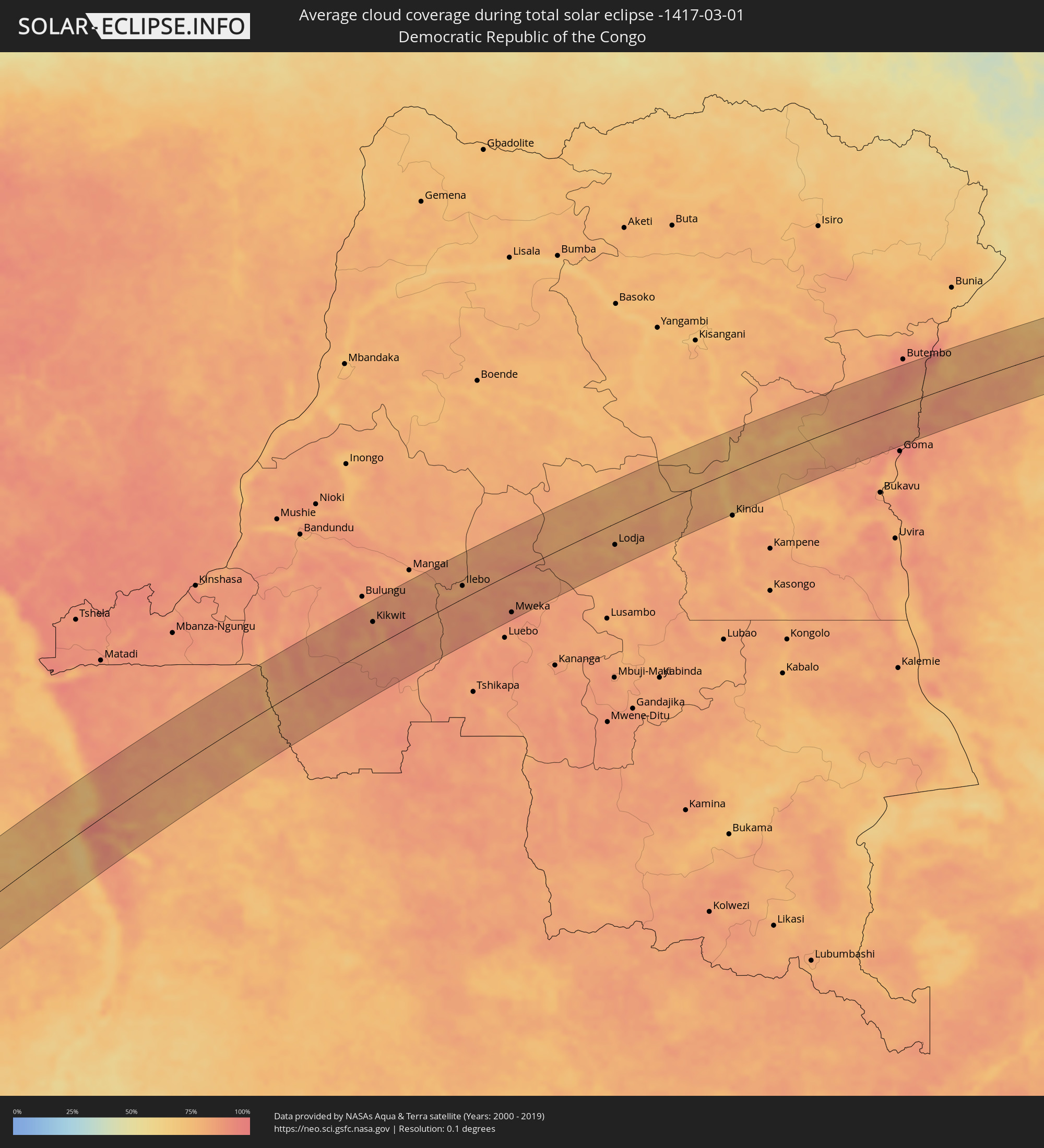 Demokratische Republik Kongo
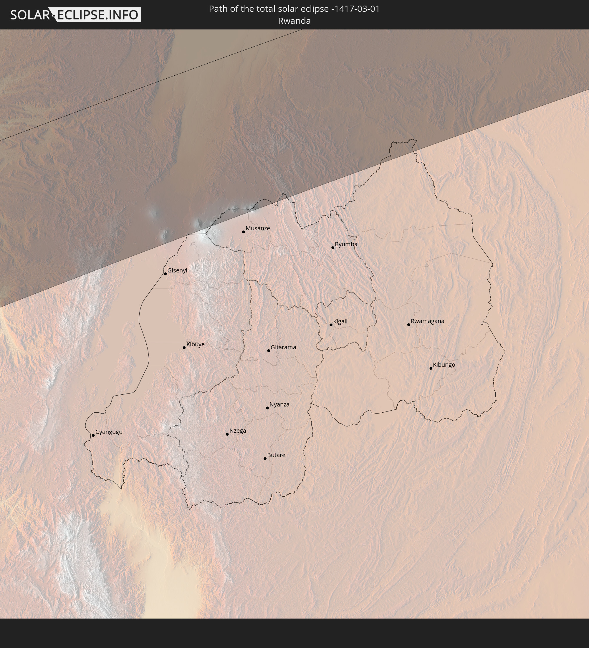
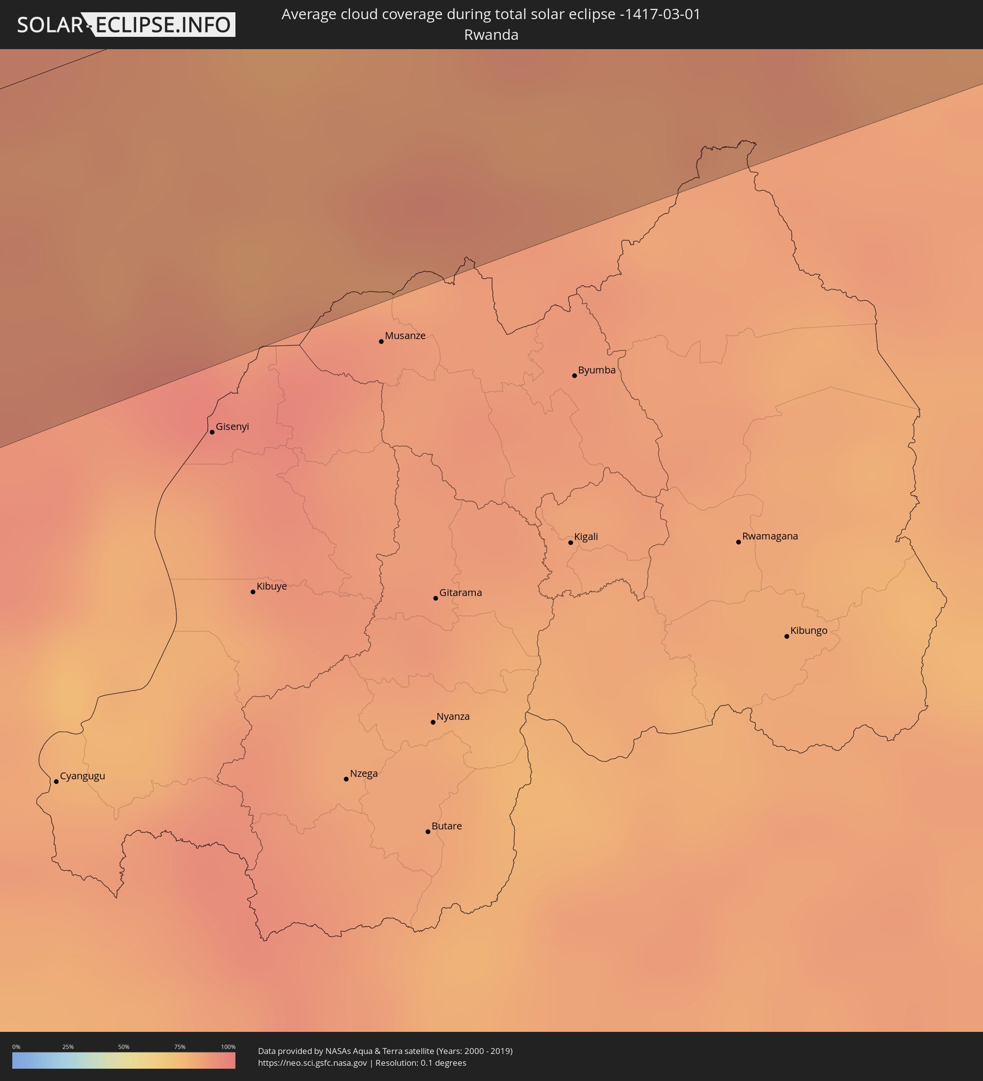 Ruanda
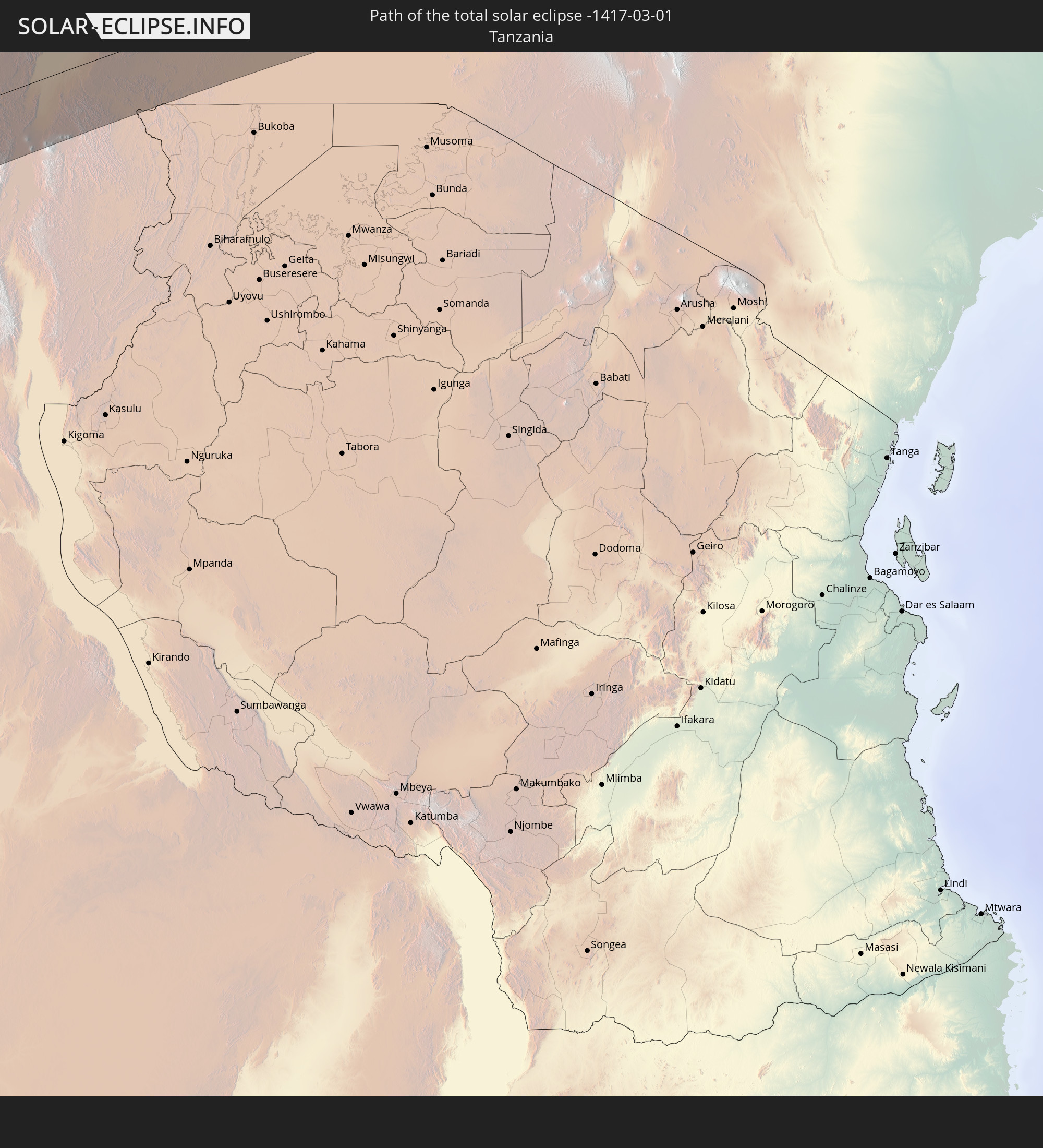
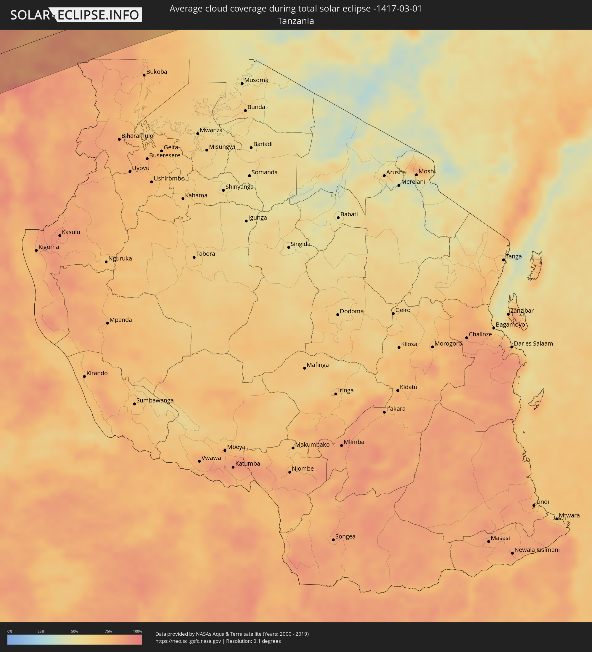 Tansania
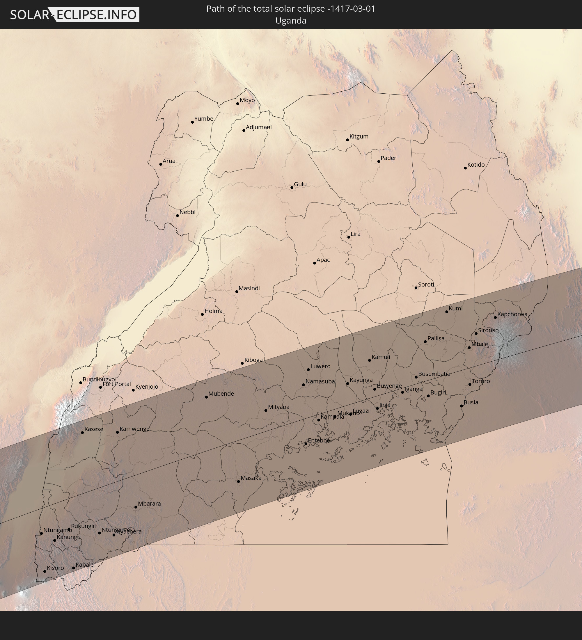
 Uganda
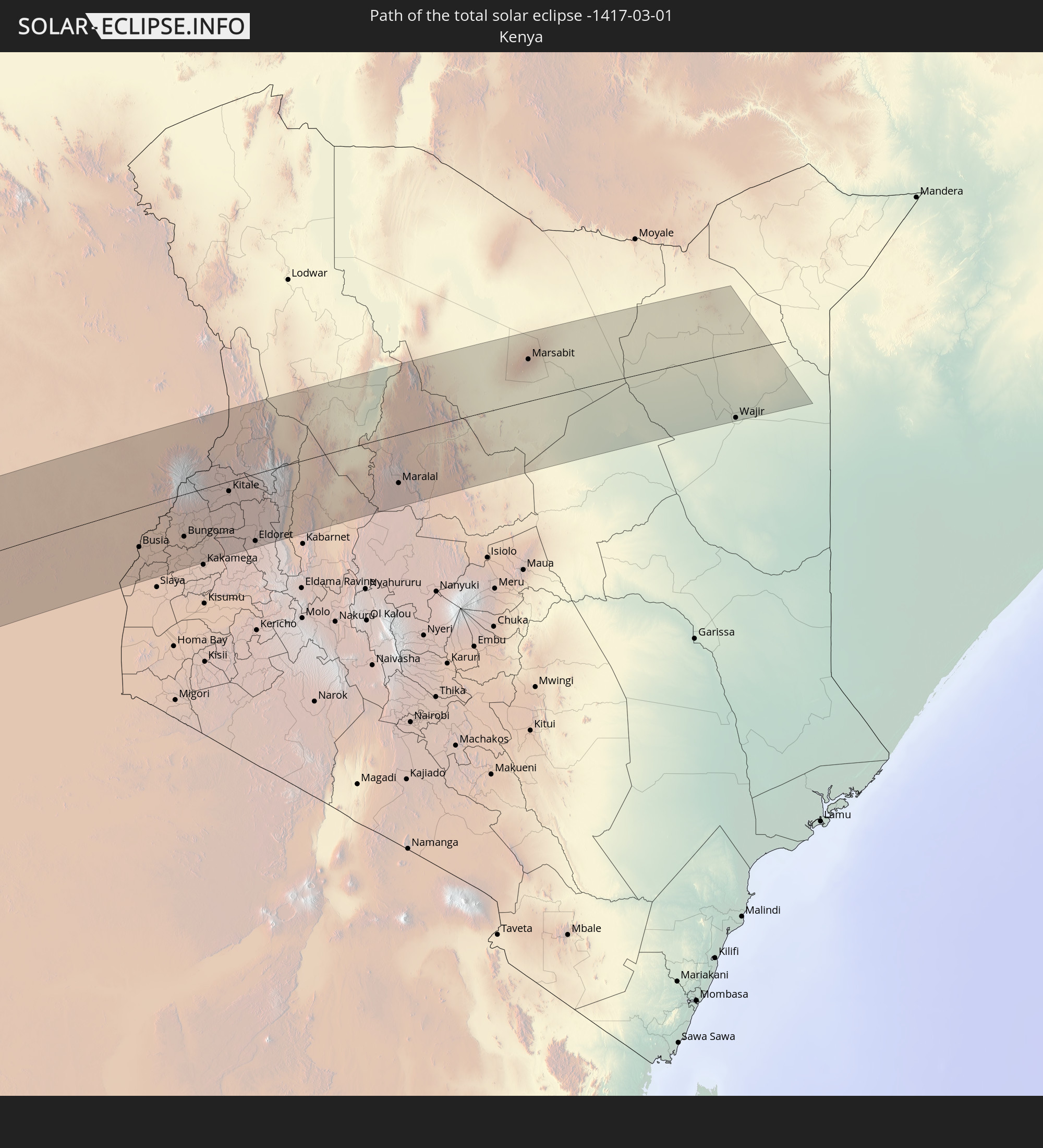
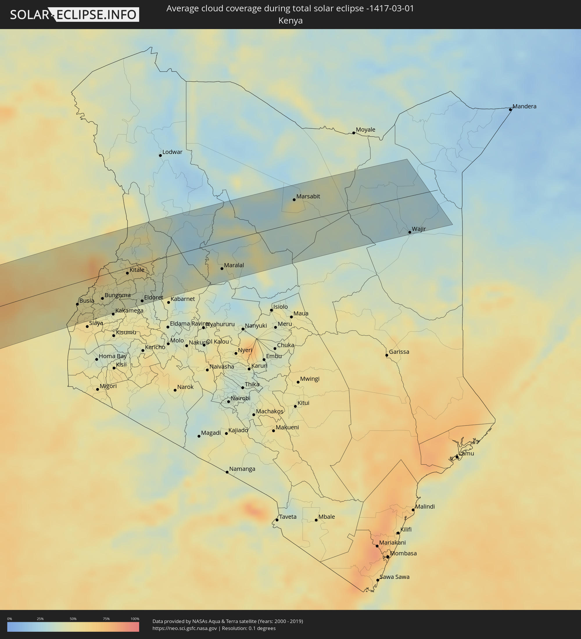 Kenia
Kenia
Orte im Finsternispfad
Die nachfolgene Tabelle zeigt Städte und Orte mit mehr als 5.000 Einwohnern, die sich im Finsternispfad befinden. Städte mit mehr als 100.000 Einwohnern sind dick gekennzeichnet. Mit einem Klick auf den Ort öffnet sich eine Detailkarte die die Lage des jeweiligen Ortes zusammen mit dem Verlauf der zentralen Finsternis präsentiert.
| Ort | Typ | Dauer der Verfinsterung | Ortszeit bei maximaler Verfinsterung | Entfernung zur Zentrallinie | Ø Bewölkung |
|
Punta Arenas, Magallanes
|
total | - | 07:50:35 UTC-04:42 | 43 km | 78% |
|
Stanley
|
total | - | 08:50:07 UTC-03:51 | 52 km | 80% |
|
Luanda, Luanda
|
total | - | 15:28:06 UTC+00:13 | 18 km | 85% |
|
Caxito, Bengo
|
total | - | 15:28:47 UTC+00:13 | 14 km | 87% |
|
Uíge, Uíge
|
total | - | 15:31:06 UTC+00:13 | 18 km | 83% |
|
Camabatela, Cuanza Norte
|
total | - | 15:30:25 UTC+00:13 | 55 km | 80% |
|
Kasongo-Lunda, Bandundu
|
total | - | 15:33:42 UTC+00:13 | 22 km | 76% |
|
Kikwit, Bandundu
|
total | - | 15:36:39 UTC+00:13 | 48 km | 88% |
|
Ilebo, Kasaï-Occidental
|
total | - | 17:35:05 UTC+02:10 | 25 km | 82% |
|
Mweka, Kasaï-Occidental
|
total | - | 17:34:47 UTC+02:10 | 76 km | 89% |
|
Lodja, Kasaï-Oriental
|
total | - | 17:37:08 UTC+02:10 | 43 km | 79% |
|
Sake, Nord Kivu
|
total | - | 17:40:32 UTC+02:10 | 77 km | 87% |
|
Ntungamo, Western Region
|
total | - | 17:58:16 UTC+02:27 | 28 km | 87% |
|
Kisoro, Western Region
|
total | - | 17:57:51 UTC+02:27 | 72 km | 86% |
|
Kanungu, Western Region
|
total | - | 17:58:13 UTC+02:27 | 41 km | 89% |
|
Rukungiri, Western Region
|
total | - | 17:58:21 UTC+02:27 | 35 km | 84% |
|
Kabale, Western Region
|
total | - | 17:57:56 UTC+02:27 | 79 km | 87% |
|
Kasese, Western Region
|
total | - | 17:59:24 UTC+02:27 | 67 km | 75% |
|
Ntungamo, Western Region
|
total | - | 17:58:20 UTC+02:27 | 51 km | 86% |
|
Nyachera, Western Region
|
total | - | 17:58:20 UTC+02:27 | 59 km | 85% |
|
Kamwenge, Western Region
|
total | - | 17:59:26 UTC+02:27 | 54 km | 80% |
|
Mbarara, Western Region
|
total | - | 17:58:39 UTC+02:27 | 36 km | 82% |
|
Mubende, Central Region
|
total | - | 17:59:52 UTC+02:27 | 59 km | 78% |
|
Masaka, Central Region
|
total | - | 17:59:00 UTC+02:27 | 47 km | 79% |
|
Mityana, Central Region
|
total | - | 17:59:46 UTC+02:27 | 23 km | 79% |
|
Namasuba, Central Region
|
total | - | 18:00:02 UTC+02:27 | 38 km | 76% |
|
Entebbe, Central Region
|
total | - | 17:59:26 UTC+02:27 | 29 km | 67% |
|
Wakiso, Central Region
|
total | - | 17:59:46 UTC+02:27 | 6 km | 80% |
|
Luwero, Central Region
|
total | - | 18:00:11 UTC+02:27 | 53 km | 72% |
|
Wobulenzi, Central Region
|
total | - | 18:00:04 UTC+02:27 | 39 km | 76% |
|
Kampala, Central Region
|
total | - | 17:59:41 UTC+02:27 | 7 km | 71% |
|
Kireka, Central Region
|
total | - | 17:59:43 UTC+02:27 | 6 km | 71% |
|
Mukono, Central Region
|
total | - | 17:59:43 UTC+02:27 | 9 km | 75% |
|
Kayunga, Central Region
|
total | - | 18:00:03 UTC+02:27 | 24 km | 73% |
|
Lugazi, Central Region
|
total | - | 17:59:45 UTC+02:27 | 12 km | 74% |
|
Kamuli, Eastern Region
|
total | - | 18:00:17 UTC+02:27 | 42 km | 60% |
|
Buwenge, Eastern Region
|
total | - | 18:00:00 UTC+02:27 | 8 km | 67% |
|
Jinja, Eastern Region
|
total | - | 17:59:48 UTC+02:27 | 15 km | 59% |
|
Iganga, Eastern Region
|
total | - | 17:59:58 UTC+02:27 | 5 km | 63% |
|
Busembatia, Eastern Region
|
total | - | 18:00:07 UTC+02:27 | 7 km | 61% |
|
Pallisa, Eastern Region
|
total | - | 18:00:28 UTC+02:27 | 44 km | 55% |
|
Bugiri, Eastern Region
|
total | - | 17:59:56 UTC+02:27 | 18 km | 59% |
|
Port Bunyala, Busia
|
total | - | 17:59:29 UTC+02:27 | 77 km | 48% |
|
Luanda, Busia
|
total | - | 17:59:40 UTC+02:27 | 58 km | 51% |
|
Busia, Eastern Region
|
total | - | 17:59:50 UTC+02:27 | 41 km | 50% |
|
Busia, Busia
|
total | - | 17:59:50 UTC+02:27 | 42 km | 50% |
|
Mbale, Eastern Region
|
total | - | 18:00:24 UTC+02:27 | 22 km | 65% |
|
Tororo, Eastern Region
|
total | - | 18:00:03 UTC+02:27 | 19 km | 51% |
|
Sironko, Eastern Region
|
total | - | 18:00:33 UTC+02:27 | 36 km | 64% |
|
Bondo, Siaya
|
total | - | 17:59:37 UTC+02:27 | 71 km | 55% |
|
Malaba, Busia
|
total | - | 17:59:59 UTC+02:27 | 29 km | 50% |
|
Lugulu, Busia
|
total | - | 17:59:46 UTC+02:27 | 55 km | 50% |
|
Mumias, Kakamega
|
total | - | 17:59:42 UTC+02:27 | 67 km | 48% |
|
Bungoma, Bungoma
|
total | - | 17:59:55 UTC+02:27 | 45 km | 47% |
|
Webuye, Bungoma
|
total | - | 17:59:57 UTC+02:27 | 47 km | 44% |
|
Kitale, Trans Nzoia
|
total | - | 18:00:19 UTC+02:27 | 11 km | 52% |
|
Kapenguria, West Pokot
|
total | - | 18:00:31 UTC+02:27 | 9 km | 54% |
|
Eldoret, Uasin Gishu
|
total | - | 17:59:51 UTC+02:27 | 72 km | 42% |
|
Kapsowar, Elegeyo-Marakwet
|
total | - | 18:00:16 UTC+02:27 | 31 km | 39% |
|
Maralal, Samburu
|
total | - | 18:00:18 UTC+02:27 | 52 km | 41% |
|
Marsabit, Marsabit
|
total | - | 18:01:14 UTC+02:27 | 45 km | 50% |
|
Wajir, Wajir
|
total | - | 18:00:28 UTC+02:27 | 71 km | 31% |