Totale Sonnenfinsternis vom 14.05.1230
| Wochentag: | Dienstag |
| Maximale Dauer der Verfinsterung: | 03m17s |
| Maximale Breite des Finsternispfades: | 476 km |
| Saroszyklus: | 96 |
| Bedeckungsgrad: | 100% |
| Magnitude: | 1.0597 |
| Gamma: | 0.9078 |
Wo kann man die Sonnenfinsternis vom 14.05.1230 sehen?
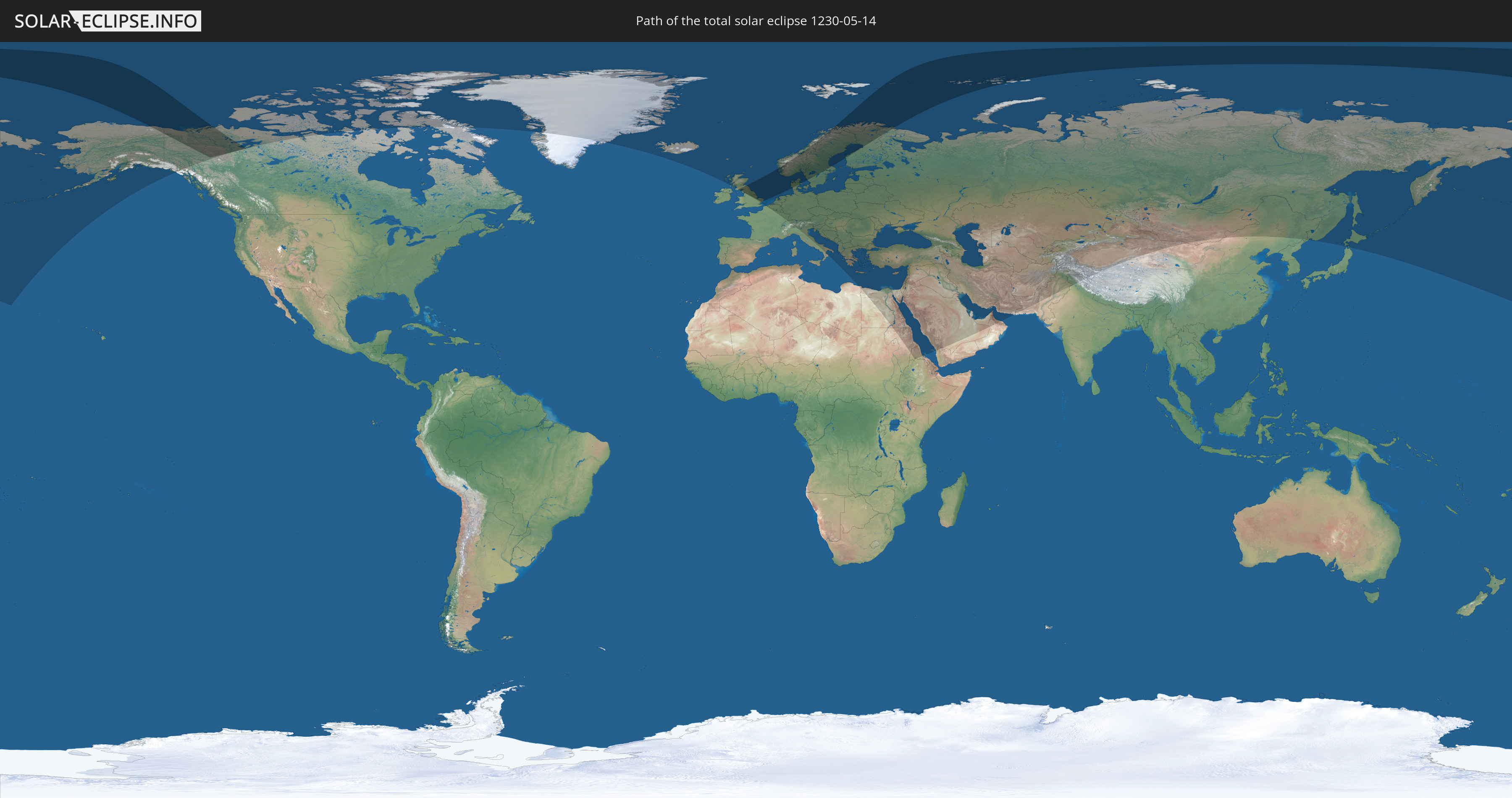
Die Sonnenfinsternis am 14.05.1230 kann man in 79 Ländern als partielle Sonnenfinsternis beobachten.
Der Finsternispfad verläuft durch 9 Länder. Nur in diesen Ländern ist sie als totale Sonnenfinsternis zu sehen.
In den folgenden Ländern ist die Sonnenfinsternis total zu sehen
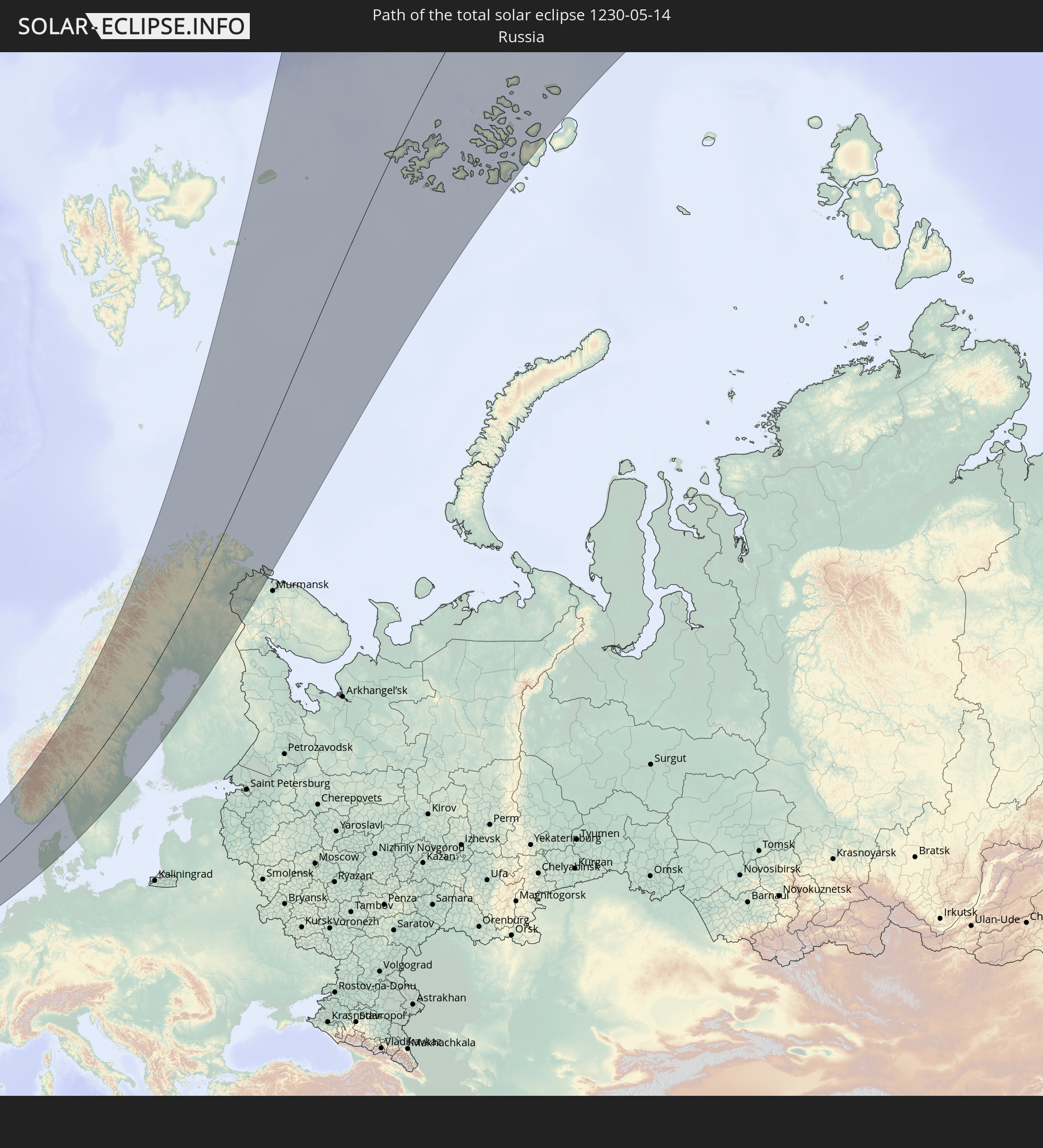 Russland
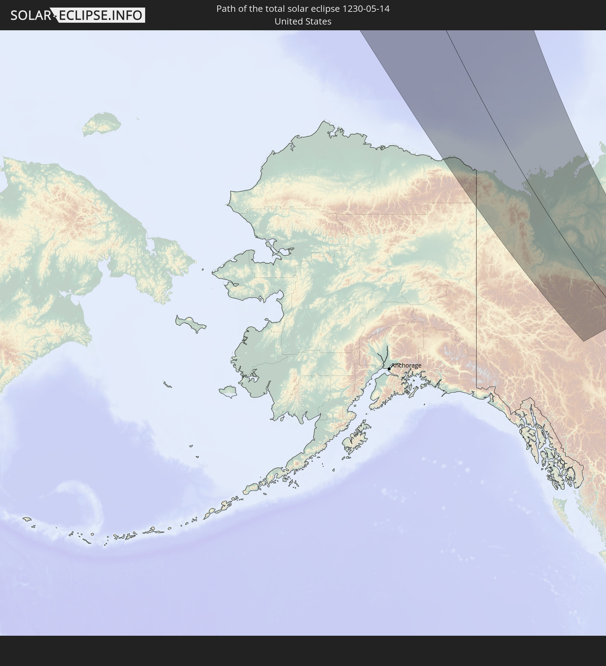 Vereinigte Staaten
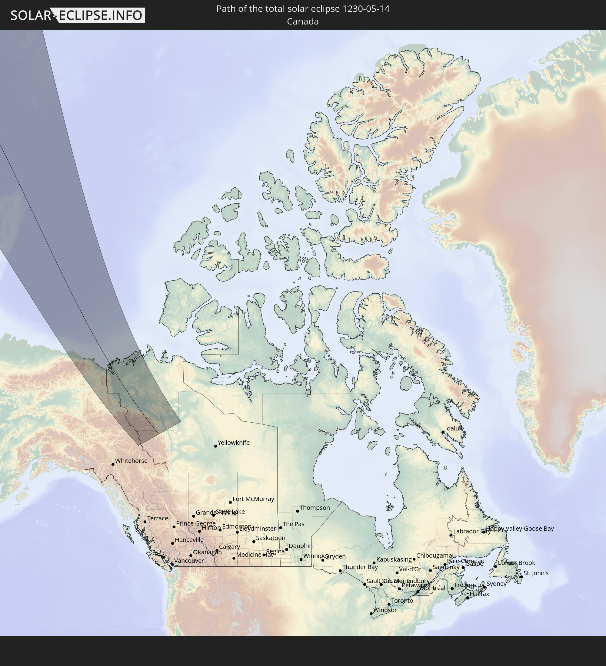 Kanada
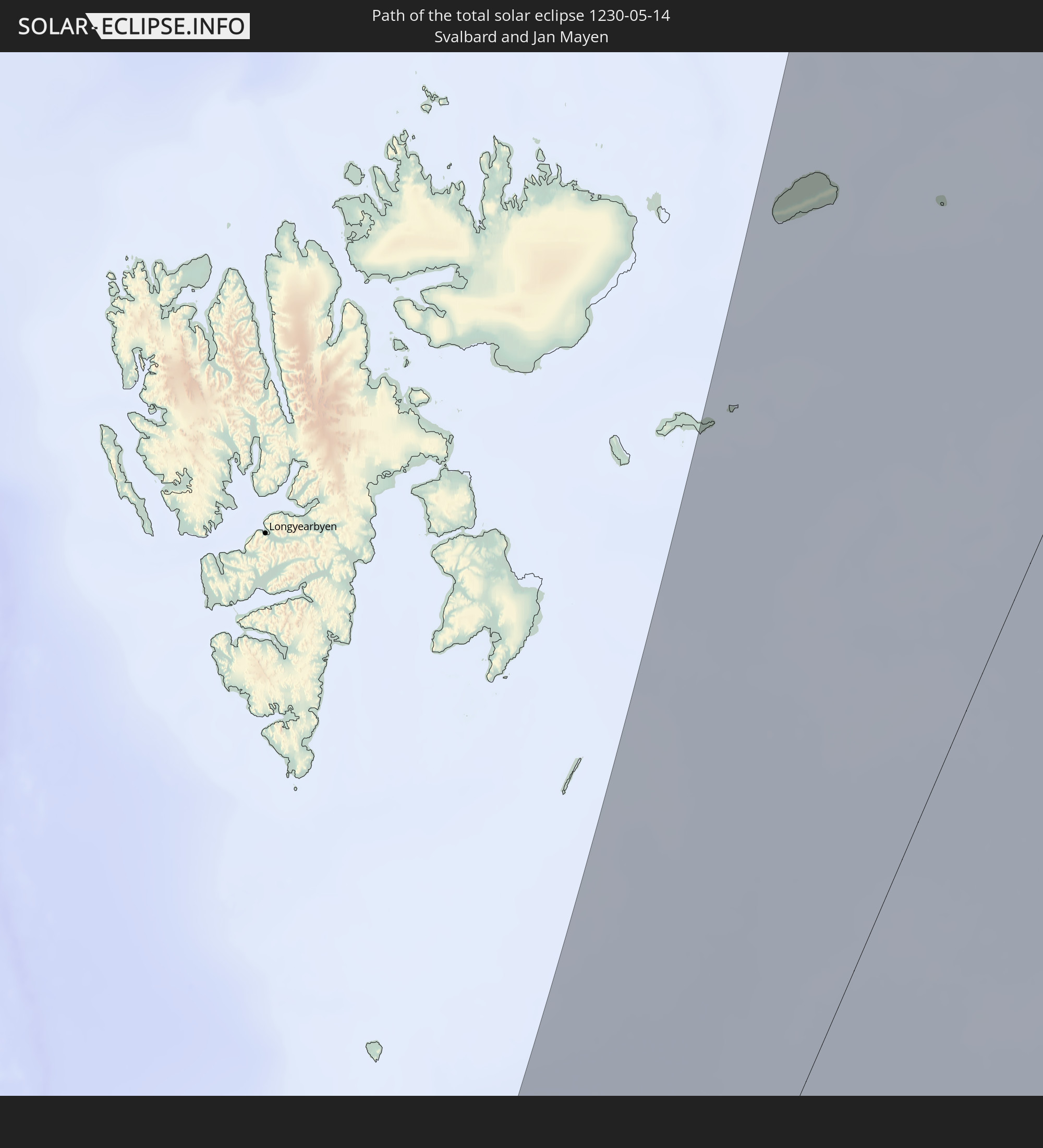 Spitzbergen
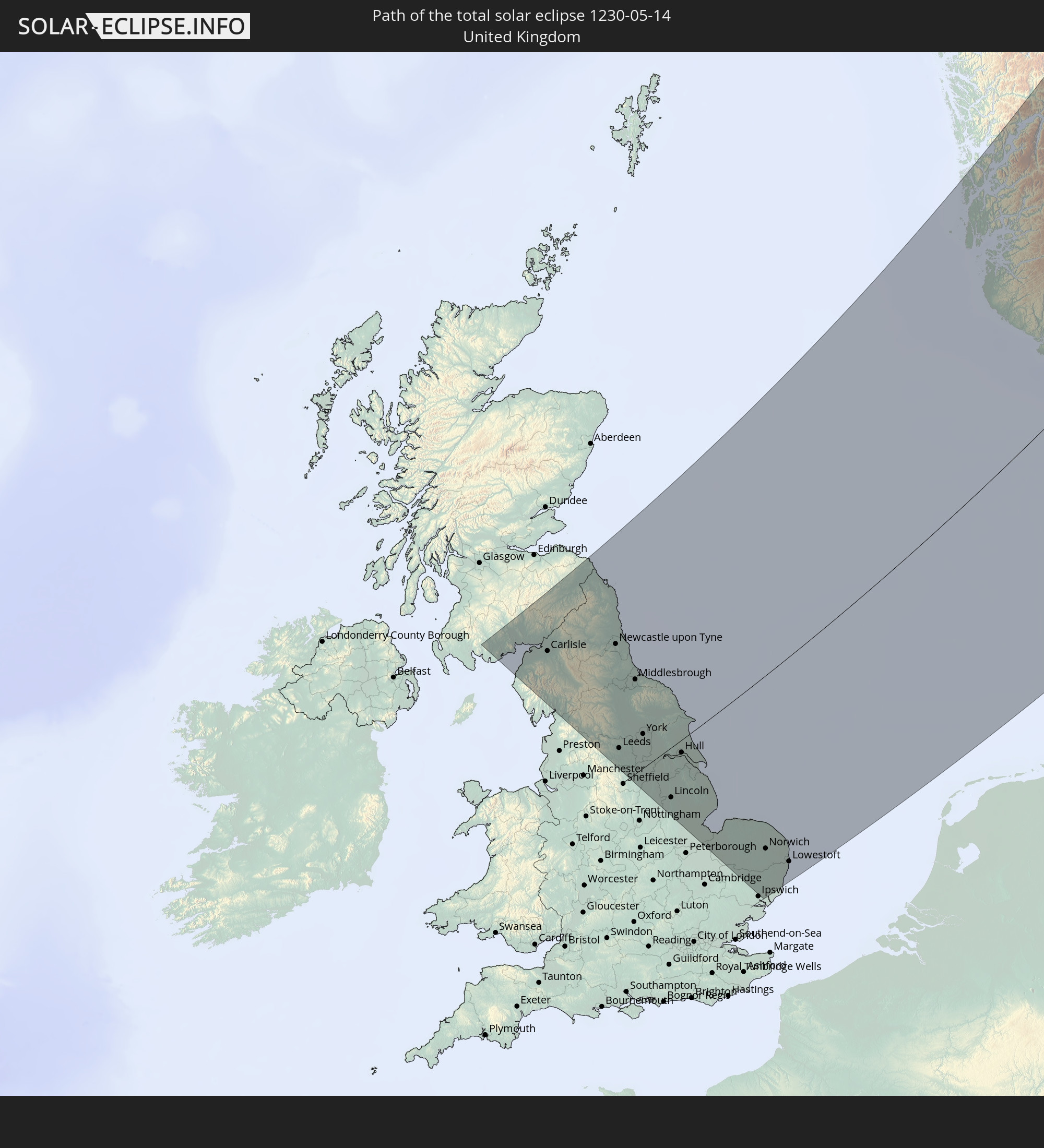 Vereinigtes Königreich
 Norwegen
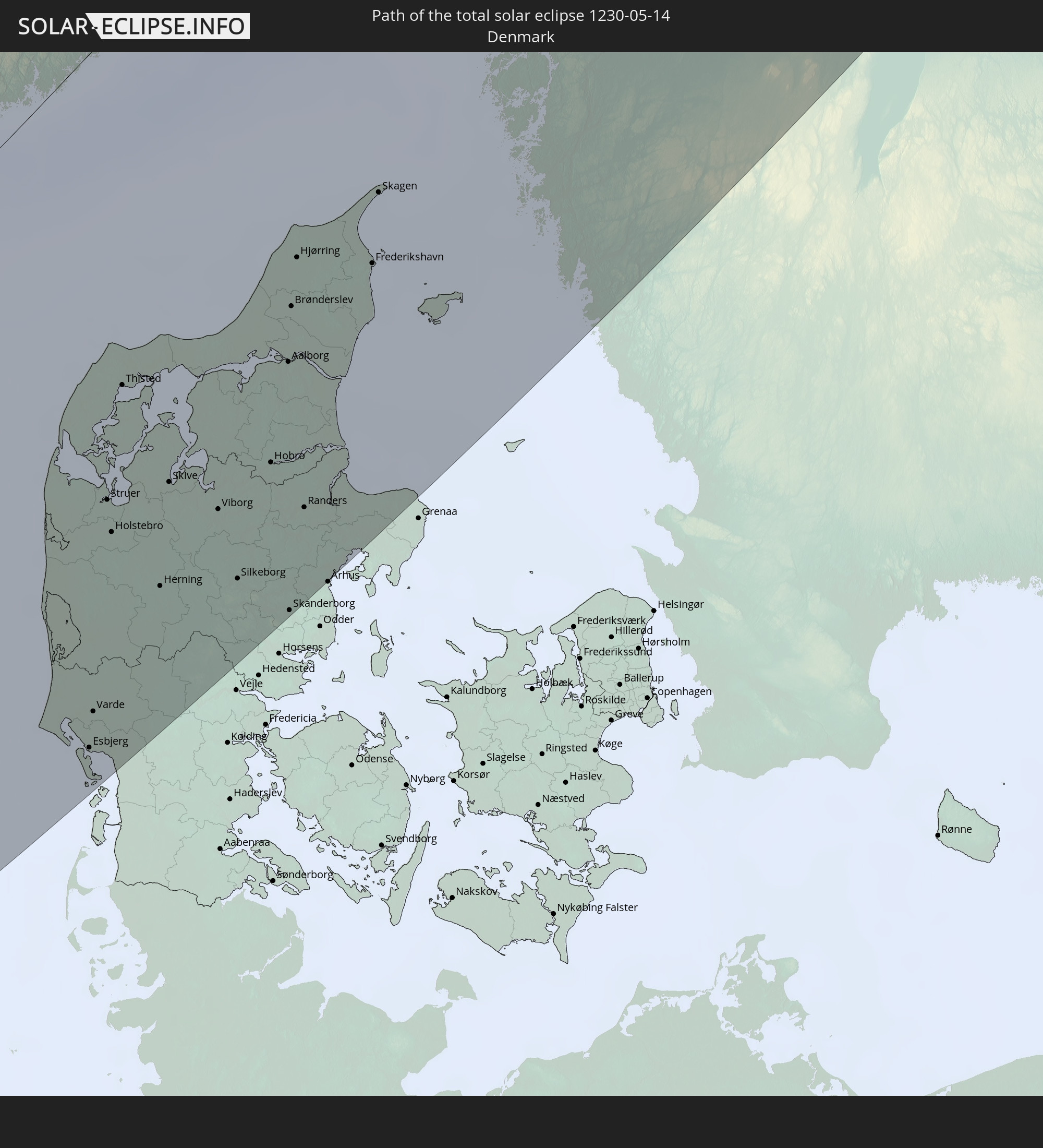 Dänemark
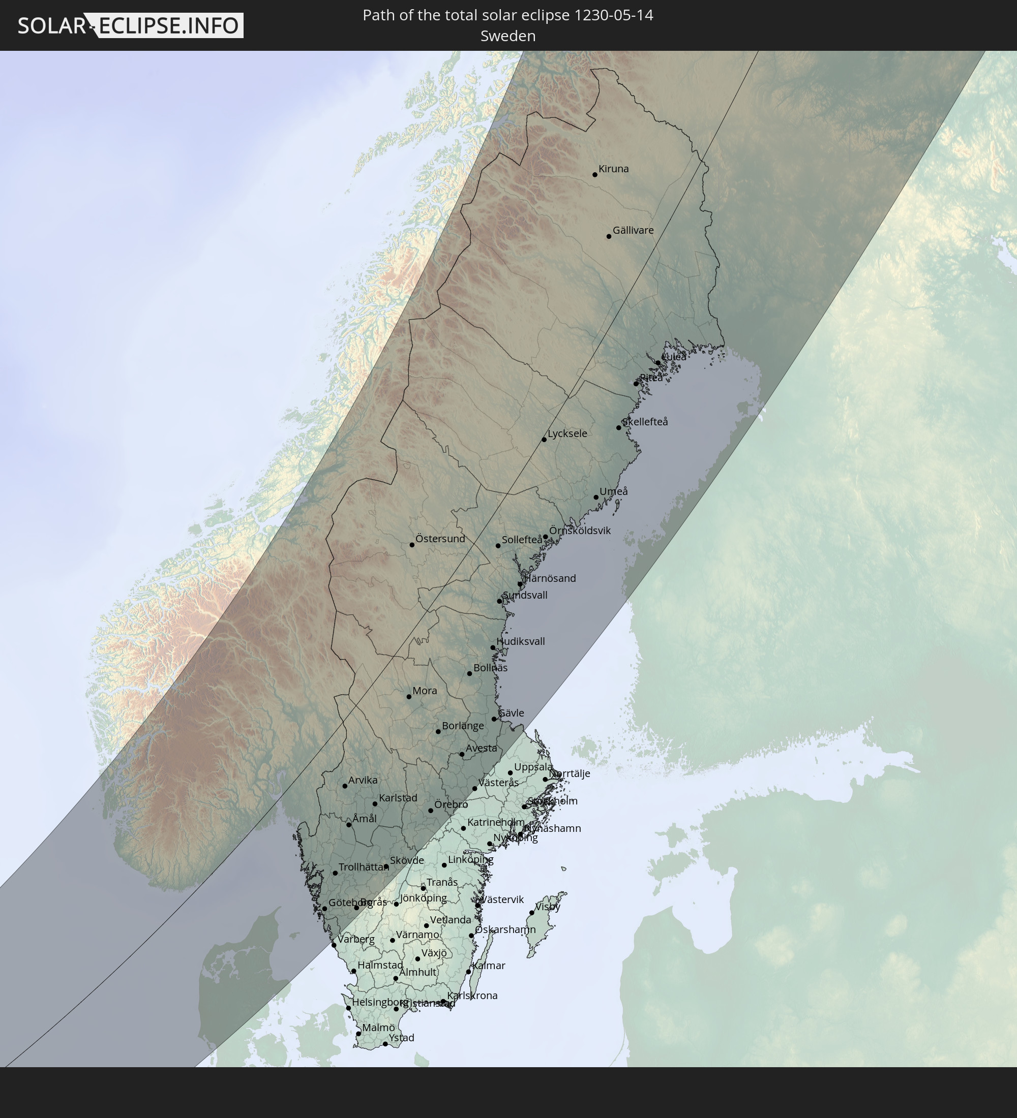 Schweden
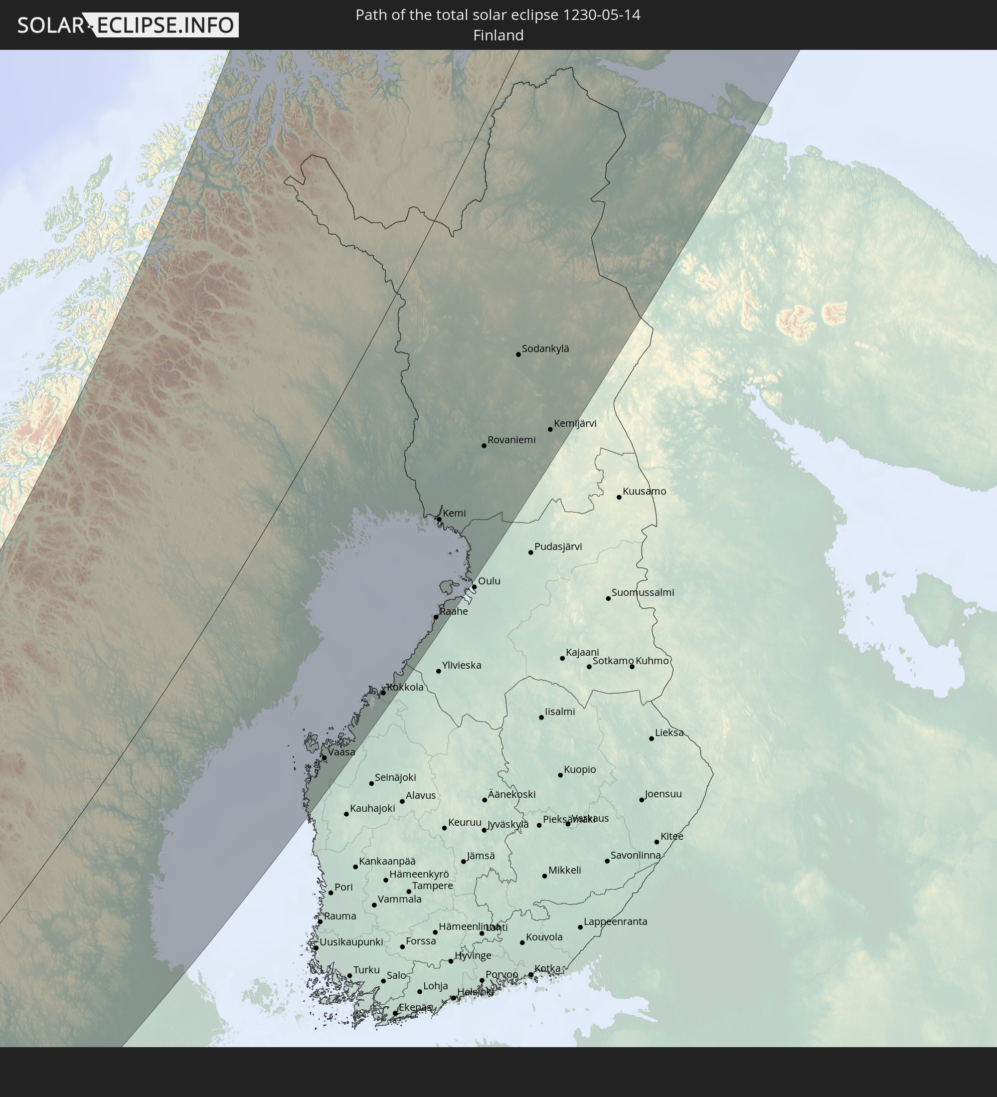 Finnland
In den folgenden Ländern ist die Sonnenfinsternis partiell zu sehen
 Russland
 Vereinigte Staaten
 United States Minor Outlying Islands
 Kanada
 Grönland
 Island
 Spitzbergen
 Vereinigtes Königreich
 Färöer
 Frankreich
 Belgien
 Niederlande
 Norwegen
 Luxemburg
 Deutschland
 Schweiz
 Italien
 Dänemark
 Libyen
 Liechtenstein
 Österreich
 Schweden
 Tschechien
 San Marino
 Slowenien
 Kroatien
 Polen
Polen
 Bosnien und Herzegowina
 Ungarn
 Slowakei
 Montenegro
 Serbien
 Albanien
 Åland Islands
 Griechenland
 Rumänien
 Mazedonien
 Finnland
 Litauen
 Lettland
 Estland
 Sudan
Sudan
 Ukraine
 Bulgarien
 Weißrussland
 Ägypten
 Türkei
 Moldawien
 Republik Zypern
 Äthiopien
 Staat Palästina
 Israel
 Saudi-Arabien
 Jordanien
 Libanon
 Syrien
 Eritrea
 Irak
Irak
 Georgien
 Jemen
Jemen
 Armenien
 Iran
Iran
 Aserbaidschan
 Kasachstan
 Kuwait
 Bahrain
 Katar
Katar
 Vereinigte Arabische Emirate
 Oman
Oman
 Turkmenistan
 Usbekistan
 Afghanistan
 Pakistan
 Tadschikistan
 Indien
 Kirgisistan
 Volksrepublik China
 Mongolei
 Japan
Japan
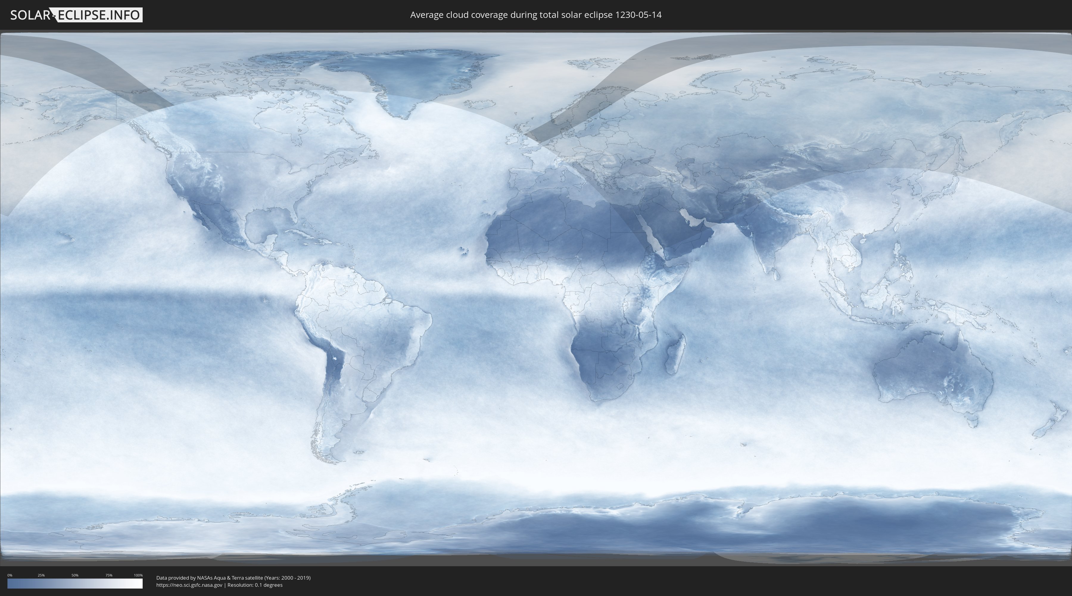
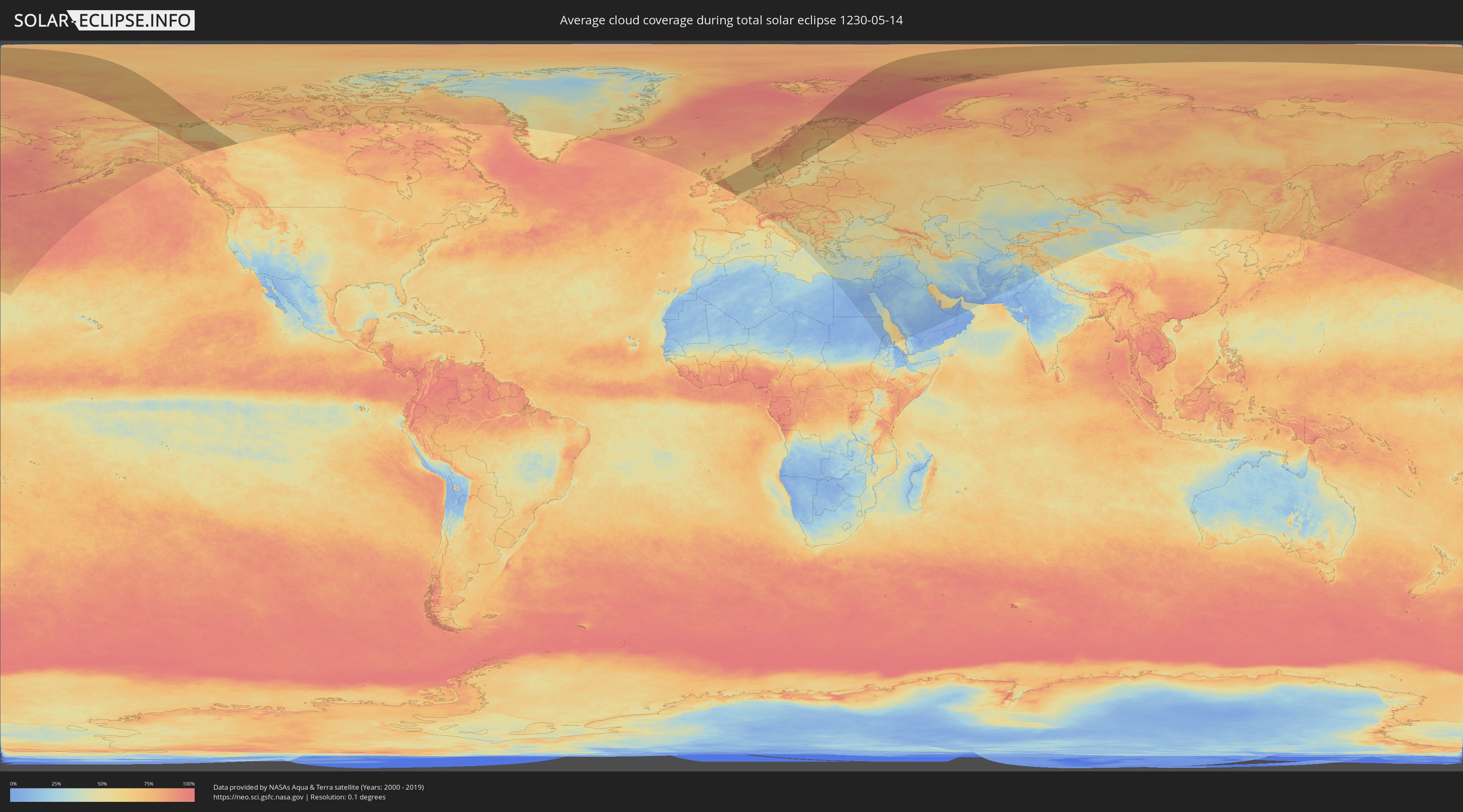
Wie wird das Wetter während der totalen Sonnenfinsternis am 14.05.1230?
Wo ist der beste Ort, um die totale Sonnenfinsternis vom 14.05.1230 zu beobachten?
Die folgenden Karten zeigen die durchschnittliche Bewölkung für den Tag, an dem die totale Sonnenfinsternis
stattfindet. Mit Hilfe der Karten lässt sich der Ort entlang des Finsternispfades eingrenzen,
der die besten Aussichen auf einen klaren wolkenfreien Himmel bietet.
Trotzdem muss man immer lokale Gegenenheiten beachten und sollte sich genau über das Wetter an seinem
gewählten Beobachtungsort informieren.
Die Daten stammen von den beiden NASA-Satelliten
AQUA und TERRA
und wurden über einen Zeitraum von 19 Jahren (2000 - 2019) gemittelt.
Detaillierte Länderkarten
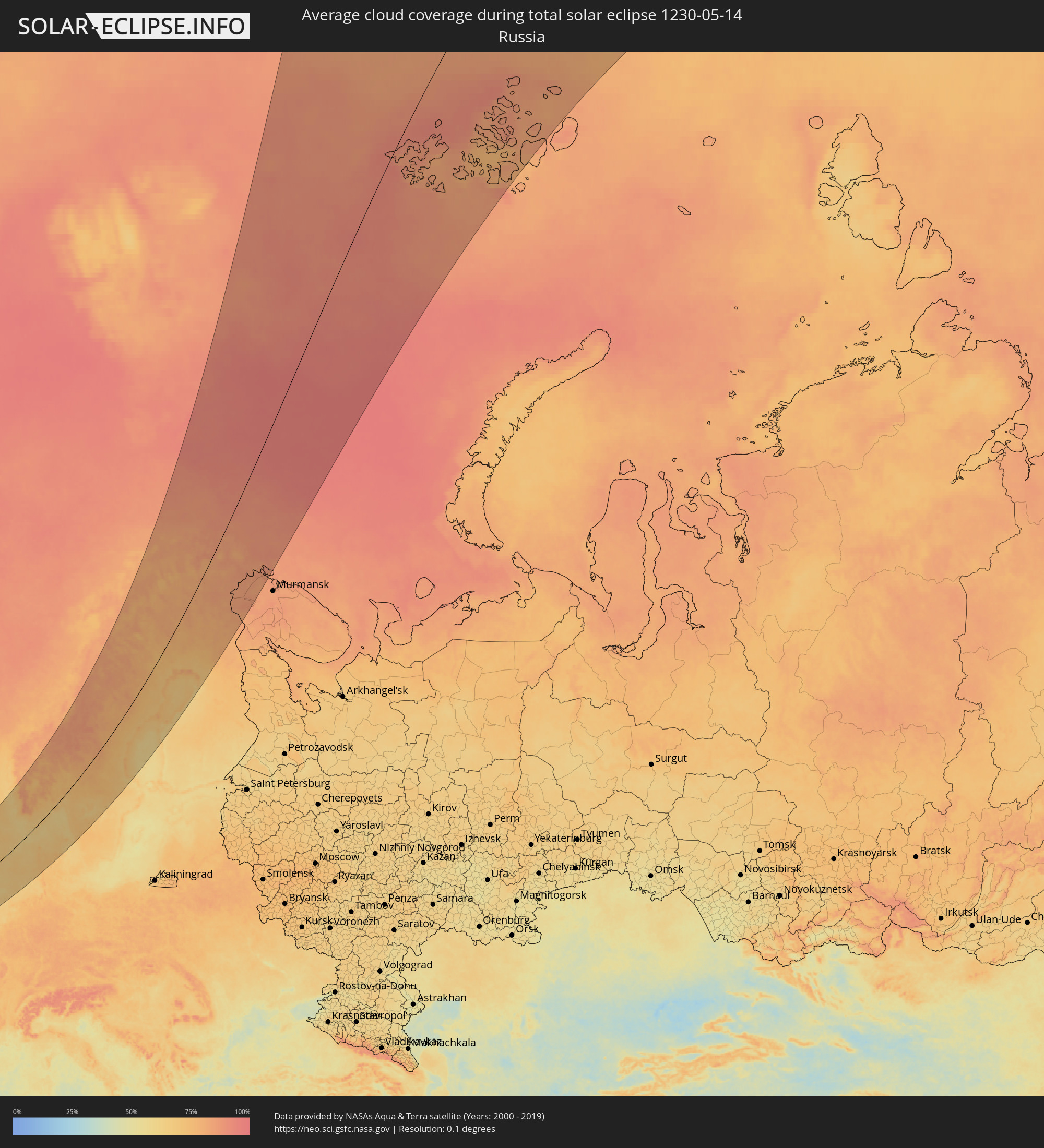 Russland
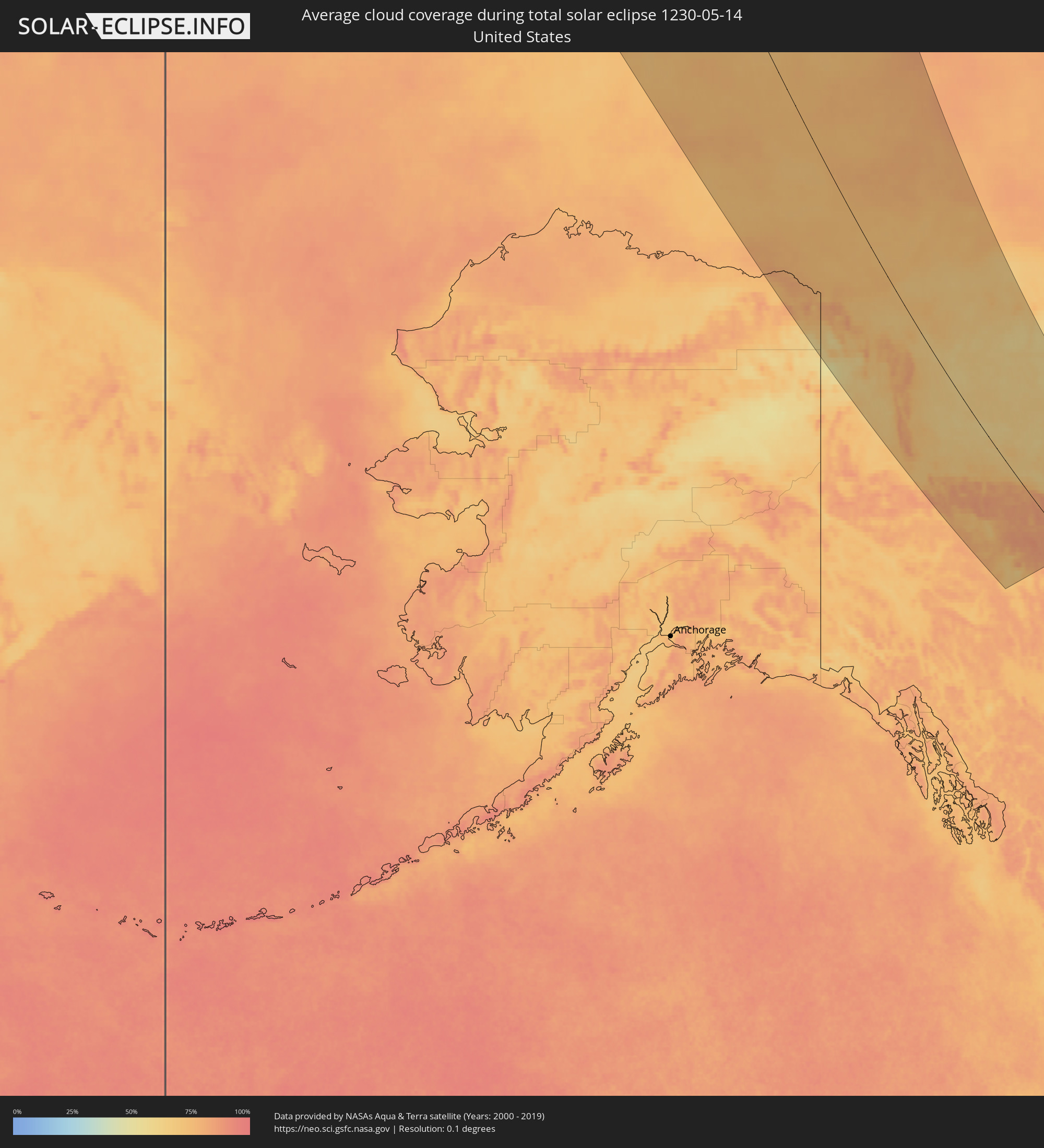 Vereinigte Staaten
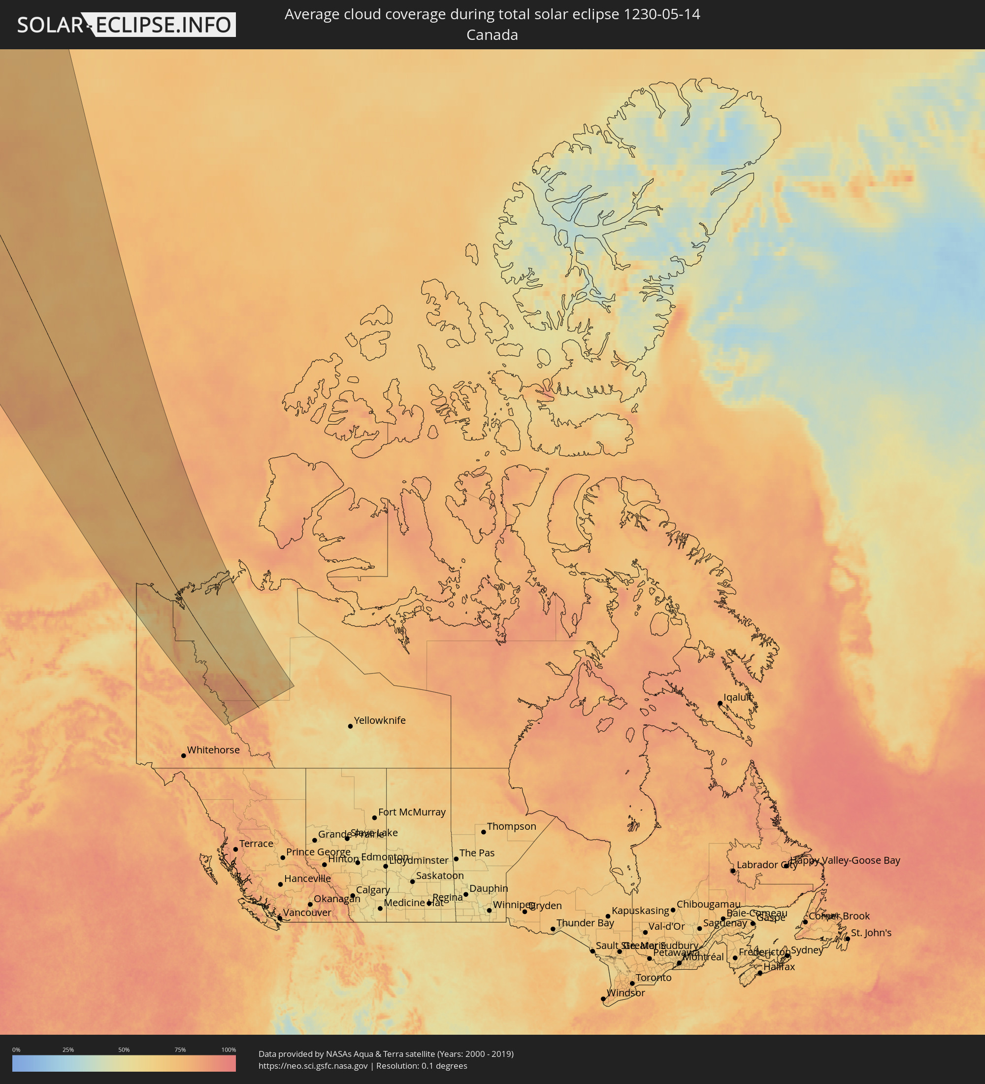 Kanada
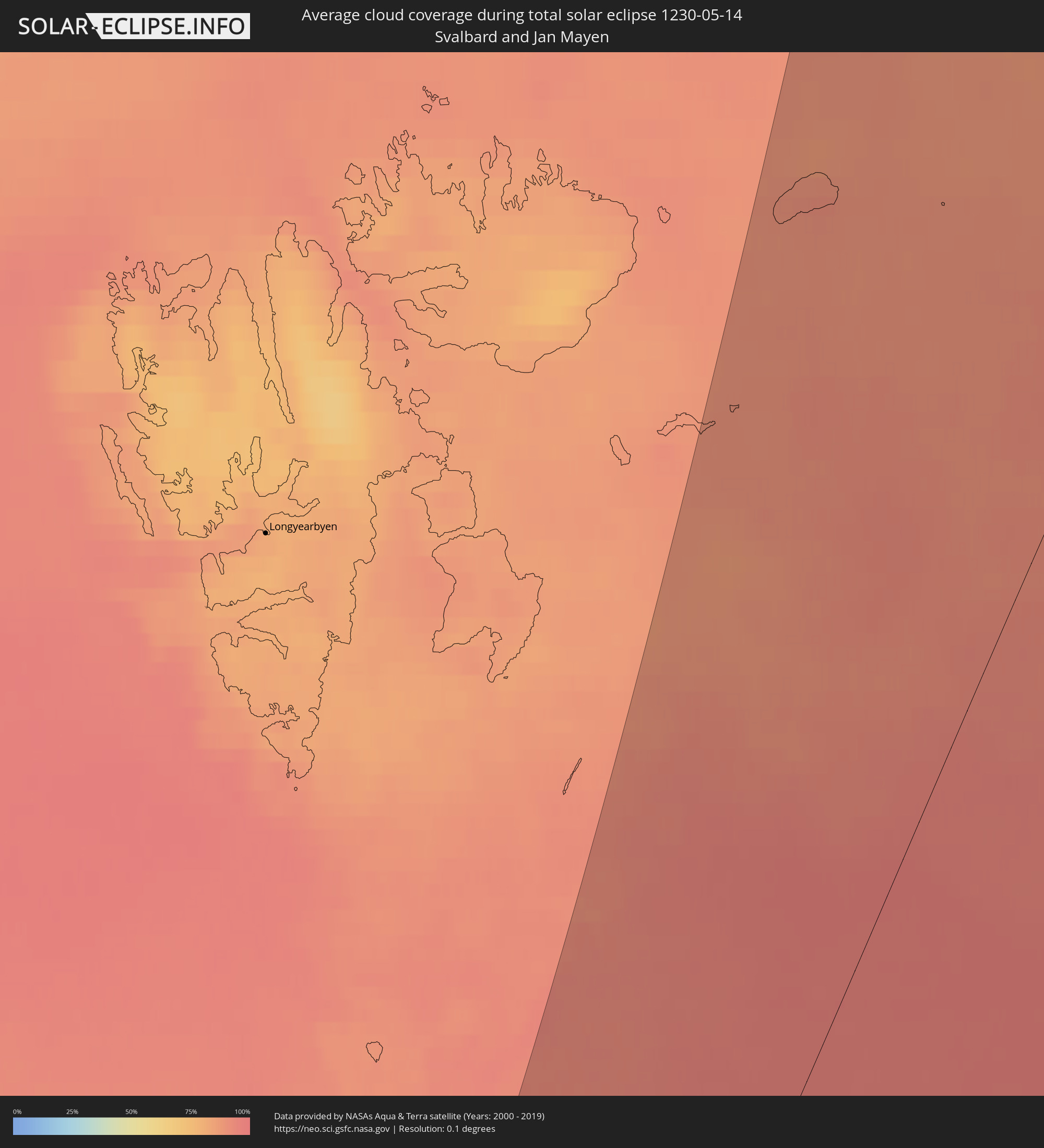 Spitzbergen
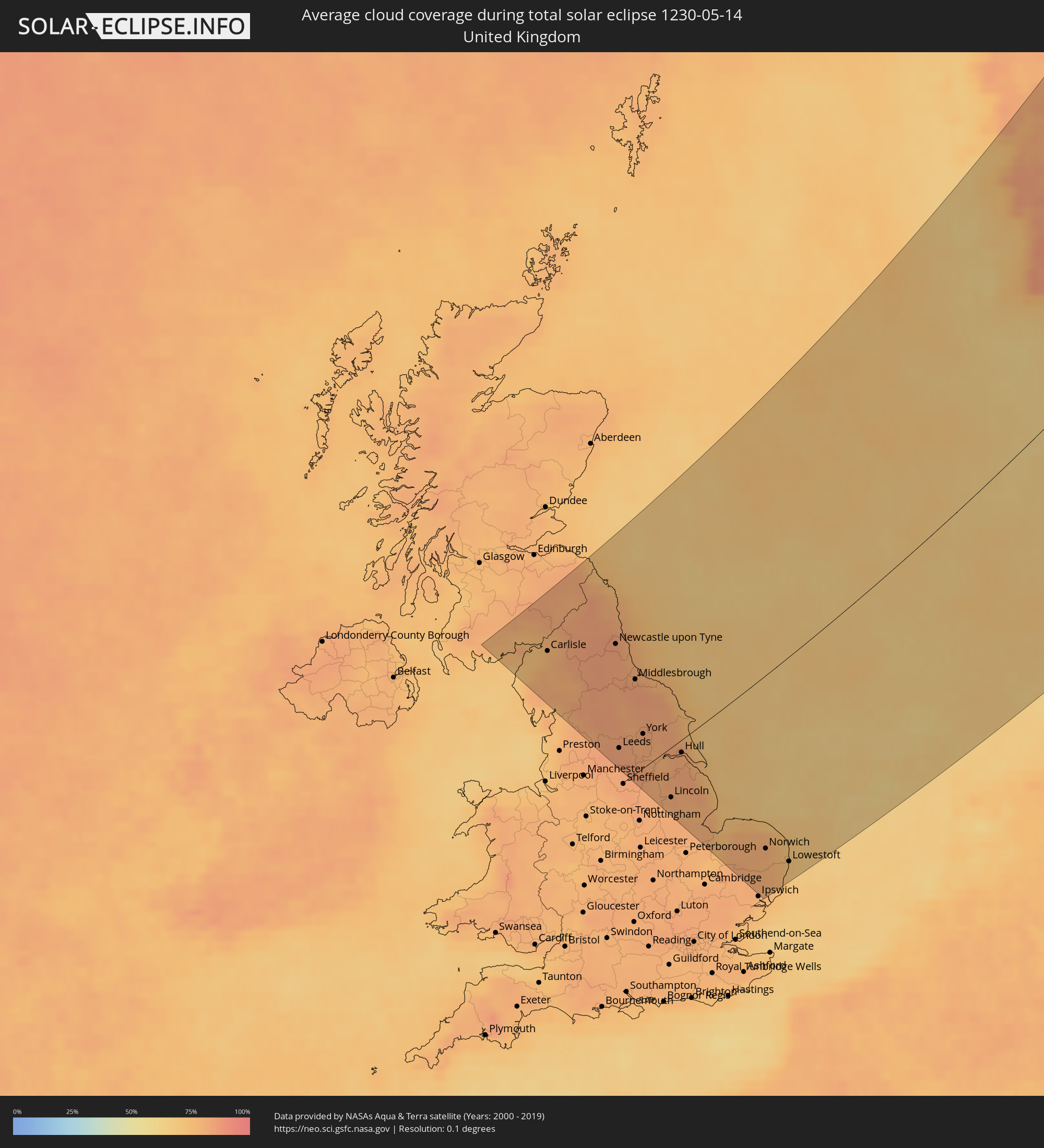 Vereinigtes Königreich
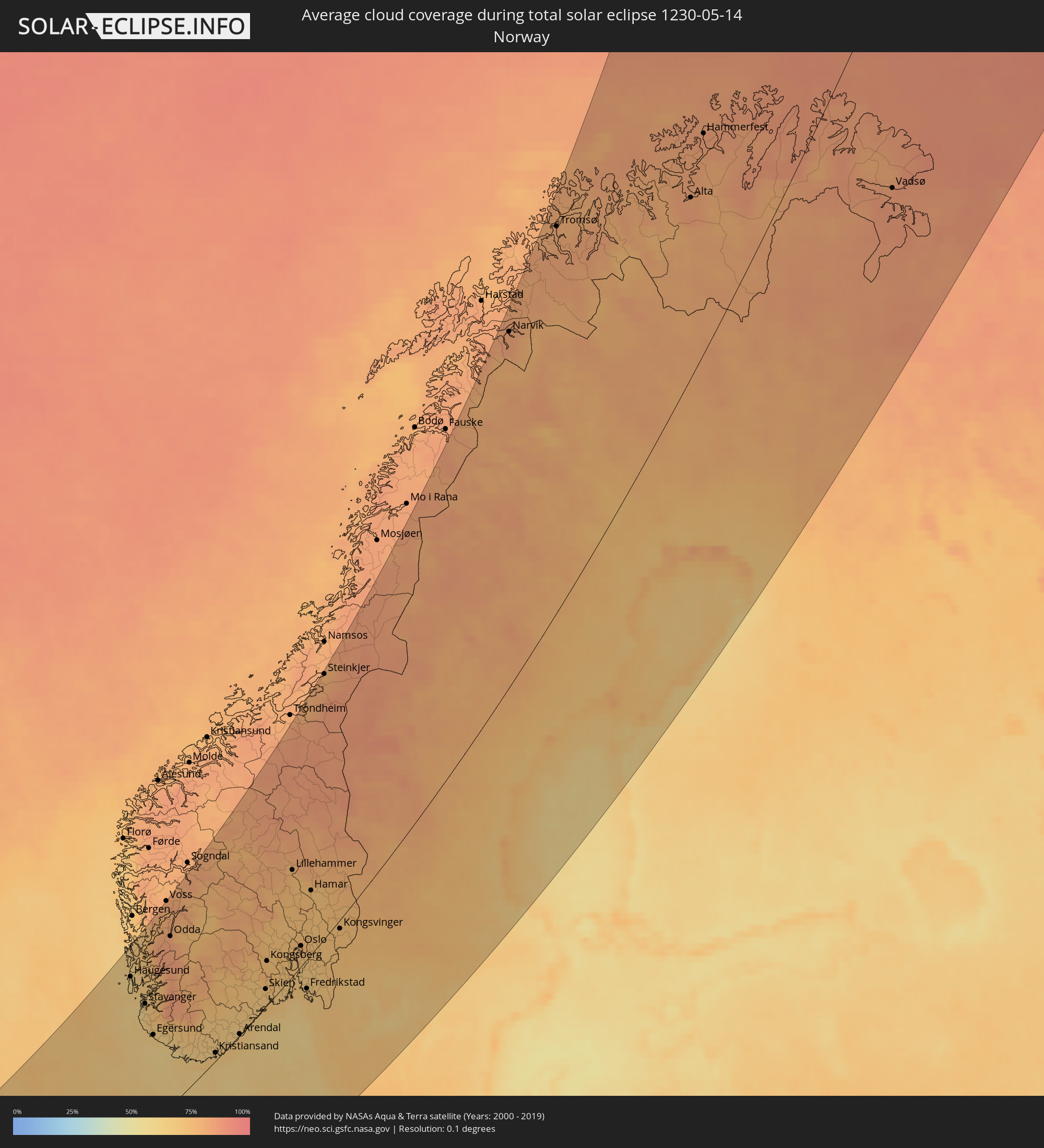 Norwegen
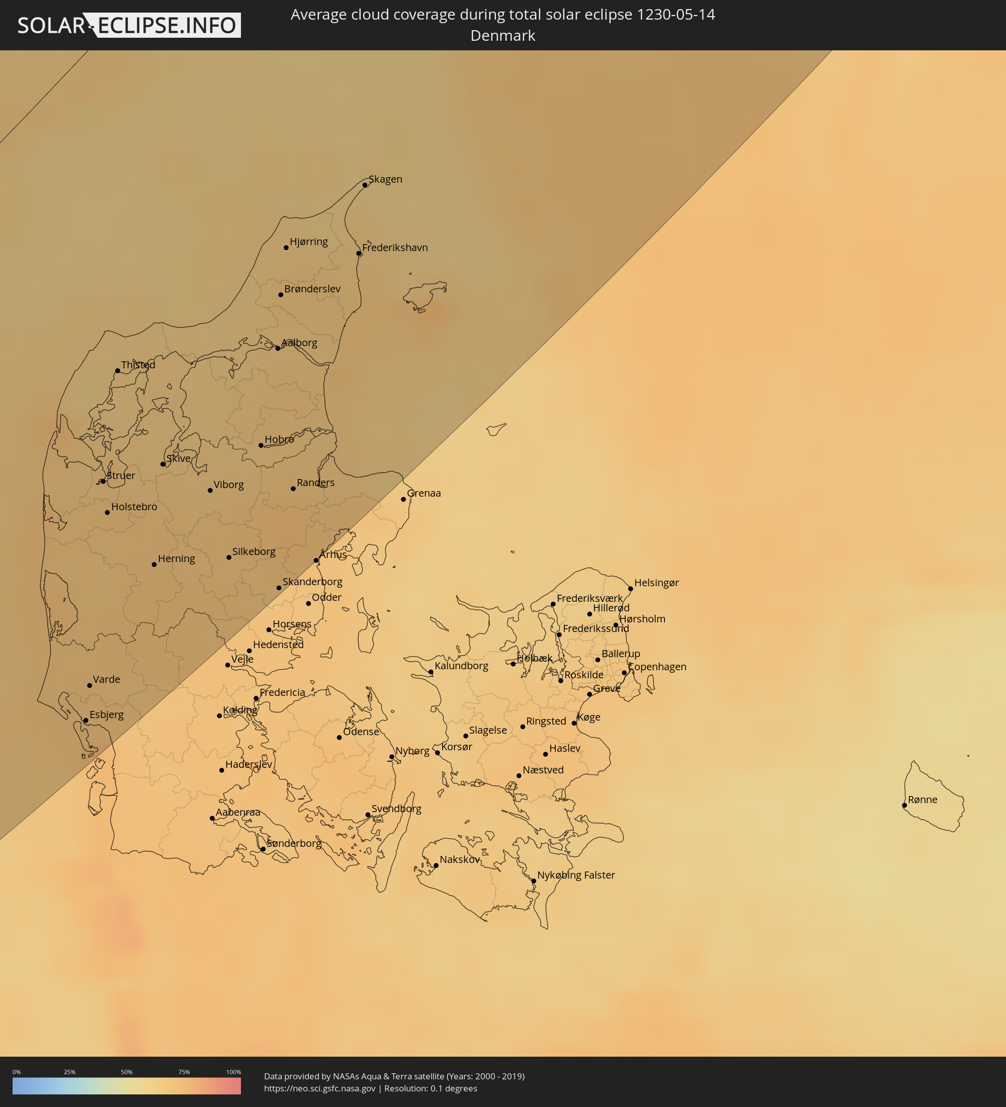 Dänemark
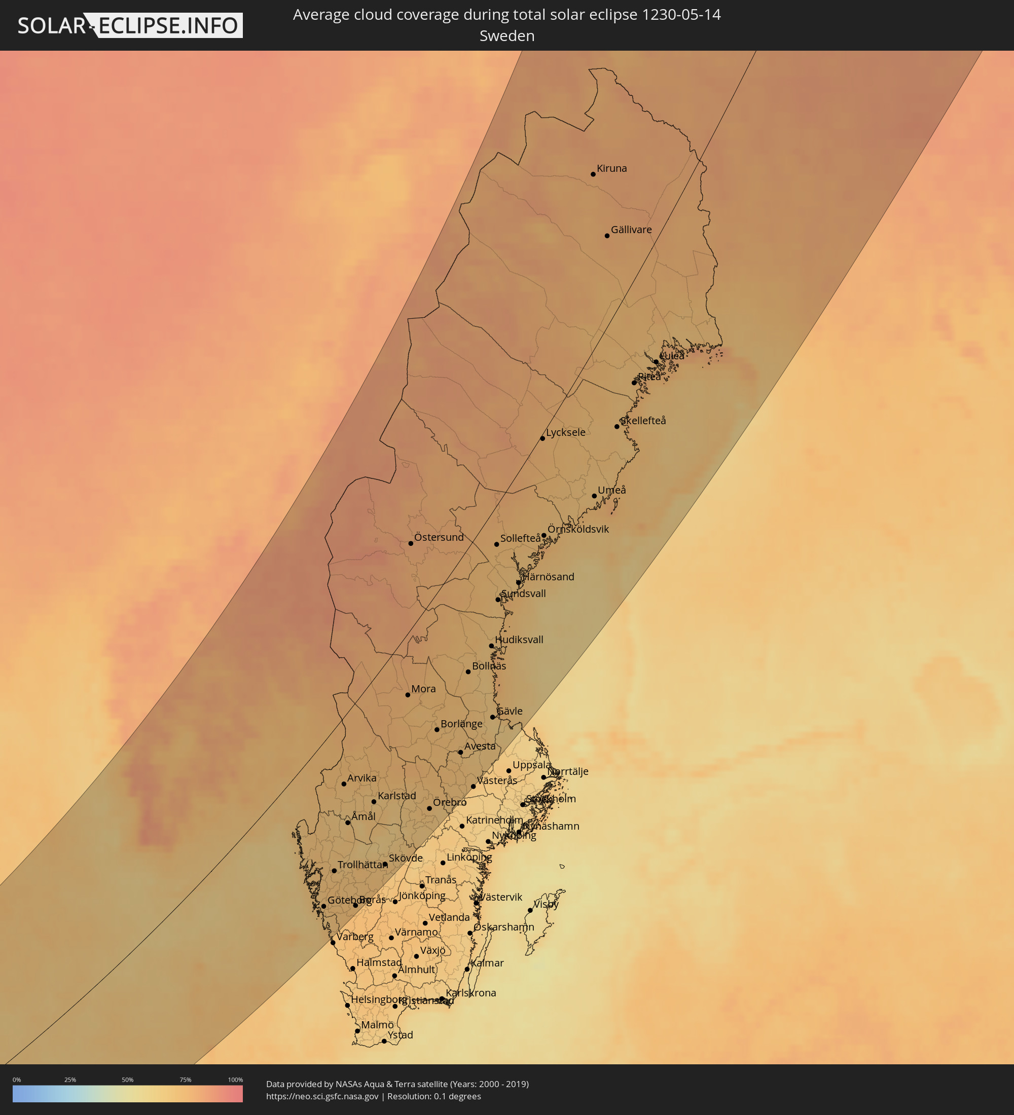 Schweden
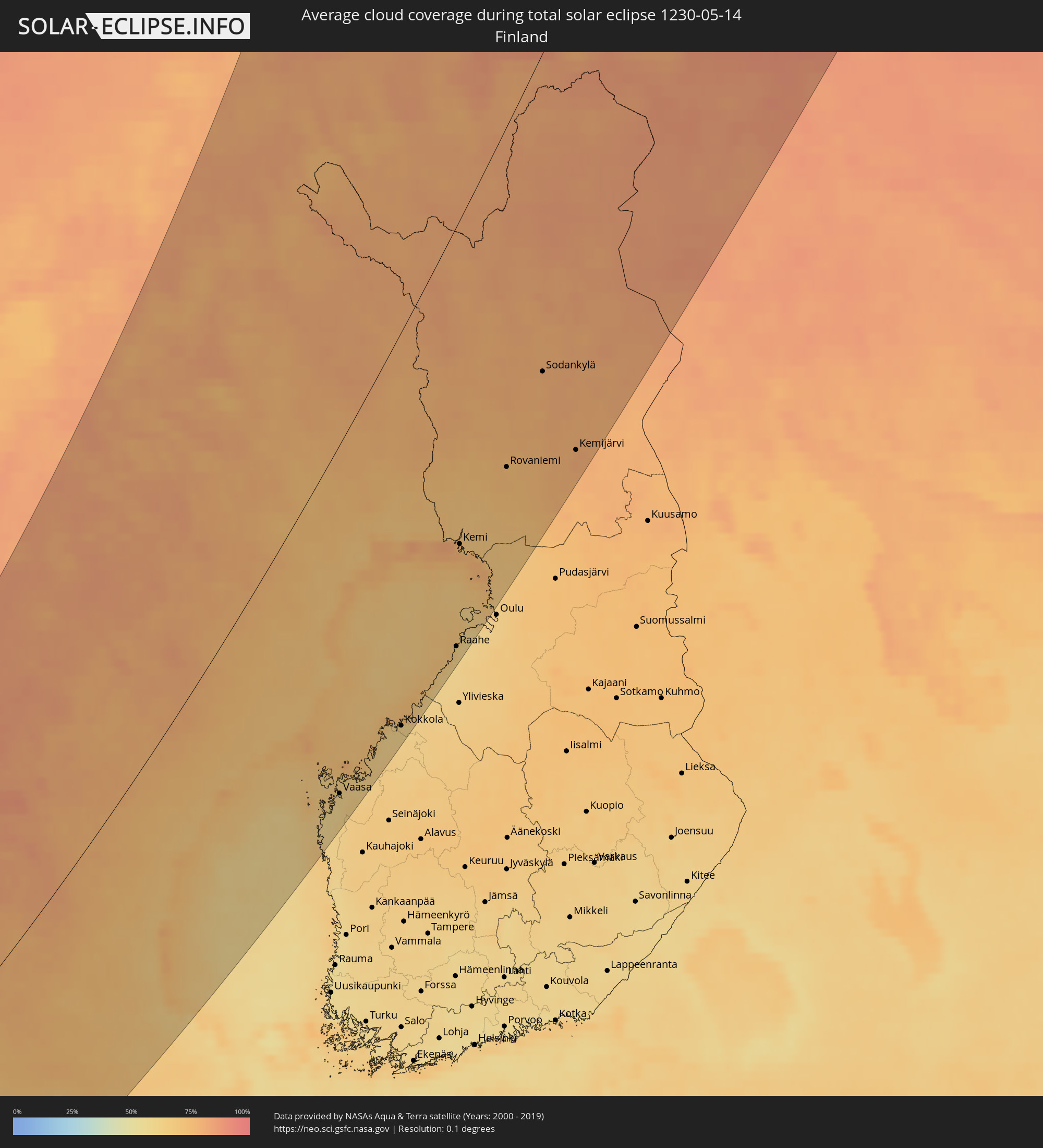 Finnland
Orte im Finsternispfad
Die nachfolgene Tabelle zeigt Städte und Orte mit mehr als 5.000 Einwohnern, die sich im Finsternispfad befinden. Städte mit mehr als 100.000 Einwohnern sind dick gekennzeichnet. Mit einem Klick auf den Ort öffnet sich eine Detailkarte die die Lage des jeweiligen Ortes zusammen mit dem Verlauf der zentralen Finsternis präsentiert.
| Ort | Typ | Dauer der Verfinsterung | Ortszeit bei maximaler Verfinsterung | Entfernung zur Zentrallinie | Ø Bewölkung |
|
Workington, England
|
total | - | 04:05:03 UTC+00:00 | 194 km | 71% |
|
Carlisle, England
|
total | - | 04:05:03 UTC+00:00 | 191 km | 78% |
|
Kendal, England
|
total | - | 04:04:16 UTC+00:00 | 133 km | 78% |
|
Berwick-Upon-Tweed, England
|
total | - | 04:05:41 UTC+00:00 | 232 km | 74% |
|
Keighley, England
|
total | - | 04:03:18 UTC+00:00 | 59 km | 83% |
|
Halifax, England
|
total | - | 04:03:05 UTC+00:00 | 43 km | 84% |
|
Consett, England
|
total | - | 04:04:27 UTC+00:00 | 144 km | 84% |
|
Newcastle upon Tyne, England
|
total | - | 04:04:30 UTC+00:00 | 146 km | 84% |
|
Durham, England
|
total | - | 04:04:14 UTC+00:00 | 127 km | 84% |
|
Darlington, England
|
total | - | 04:03:55 UTC+00:00 | 104 km | 82% |
|
Leeds, England
|
total | - | 04:03:02 UTC+00:00 | 39 km | 83% |
|
Harrogate, England
|
total | - | 04:03:16 UTC+00:00 | 56 km | 83% |
|
Blyth, England
|
total | - | 04:04:38 UTC+00:00 | 155 km | 82% |
|
Barnsley, England
|
total | - | 04:02:42 UTC+00:00 | 14 km | 83% |
|
Sunderland, England
|
total | - | 04:04:18 UTC+00:00 | 131 km | 80% |
|
Rotherham, England
|
total | - | 04:02:29 UTC+00:00 | 2 km | 83% |
|
Peterlee, England
|
total | - | 04:04:06 UTC+00:00 | 116 km | 80% |
|
Pontefract, England
|
total | - | 04:02:47 UTC+00:00 | 20 km | 83% |
|
Middlesbrough, England
|
total | - | 04:03:49 UTC+00:00 | 96 km | 84% |
|
Doncaster, England
|
total | - | 04:02:29 UTC+00:00 | 2 km | 82% |
|
York, England
|
total | - | 04:02:59 UTC+00:00 | 35 km | 83% |
|
Retford, England
|
total | - | 04:02:09 UTC+00:00 | 28 km | 81% |
|
Scunthorpe, England
|
total | - | 04:02:19 UTC+00:00 | 16 km | 80% |
|
Lincoln, England
|
total | - | 04:01:50 UTC+00:00 | 52 km | 81% |
|
Scarborough, England
|
total | - | 04:03:03 UTC+00:00 | 37 km | 76% |
|
Hull, England
|
total | - | 04:02:22 UTC+00:00 | 13 km | 80% |
|
Bridlington, England
|
total | - | 04:02:42 UTC+00:00 | 12 km | 73% |
|
Spalding, England
|
total | - | 04:01:06 UTC+00:00 | 107 km | 78% |
|
Cleethorpes, England
|
total | - | 04:01:59 UTC+00:00 | 41 km | 77% |
|
Boston, England
|
total | - | 04:01:16 UTC+00:00 | 94 km | 79% |
|
King's Lynn, England
|
total | - | 04:00:47 UTC+00:00 | 131 km | 76% |
|
Thetford, England
|
total | - | 04:00:12 UTC+00:00 | 175 km | 80% |
|
Norwich, England
|
total | - | 04:00:11 UTC+00:00 | 178 km | 79% |
|
Lowestoft, England
|
total | - | 03:59:47 UTC+00:00 | 209 km | 70% |
|
Haugesund, Rogaland
|
total | - | 05:07:27 UTC+01:00 | 222 km | 61% |
|
Leirvik, Hordaland
|
total | - | 05:07:54 UTC+01:00 | 239 km | 71% |
|
Stavanger, Rogaland
|
total | - | 05:06:40 UTC+01:00 | 169 km | 63% |
|
Egersund, Rogaland
|
total | - | 05:05:51 UTC+01:00 | 119 km | 66% |
|
Mandal, Vest-Agder
|
total | - | 05:04:44 UTC+01:00 | 25 km | 68% |
|
Søgne, Vest-Agder
|
total | - | 05:04:43 UTC+01:00 | 16 km | 69% |
|
Kristiansand, Vest-Agder
|
total | - | 05:04:43 UTC+01:00 | 11 km | 67% |
|
Ringkøbing, Central Jutland
|
total | - | 05:01:44 UTC+01:00 | 163 km | 72% |
|
Lemvig, Central Jutland
|
total | - | 05:02:21 UTC+01:00 | 129 km | 68% |
|
Esbjerg, South Denmark
|
total | - | 05:00:48 UTC+01:00 | 223 km | 71% |
|
Varde, South Denmark
|
total | - | 05:01:00 UTC+01:00 | 211 km | 69% |
|
Skjern, Central Jutland
|
total | - | 05:01:27 UTC+01:00 | 185 km | 70% |
|
Struer, Central Jutland
|
total | - | 05:02:11 UTC+01:00 | 145 km | 70% |
|
Grimstad, Aust-Agder
|
total | - | 05:04:48 UTC+01:00 | 8 km | 68% |
|
Holstebro, Central Jutland
|
total | - | 05:01:59 UTC+01:00 | 157 km | 71% |
|
Thisted, North Denmark
|
total | - | 05:02:47 UTC+01:00 | 112 km | 65% |
|
Bramming, South Denmark
|
total | - | 05:00:43 UTC+01:00 | 233 km | 70% |
|
Arendal, Aust-Agder
|
total | - | 05:04:55 UTC+01:00 | 18 km | 67% |
|
Nykøbing Mors, North Denmark
|
total | - | 05:02:30 UTC+01:00 | 132 km | 65% |
|
Grindsted, South Denmark
|
total | - | 05:01:02 UTC+01:00 | 219 km | 71% |
|
Herning, Central Jutland
|
total | - | 05:01:33 UTC+01:00 | 190 km | 72% |
|
Skive, Central Jutland
|
total | - | 05:02:07 UTC+01:00 | 158 km | 68% |
|
Brande, Central Jutland
|
total | - | 05:01:13 UTC+01:00 | 212 km | 71% |
|
Ikast, Central Jutland
|
total | - | 05:01:29 UTC+01:00 | 198 km | 71% |
|
Viborg, Central Jutland
|
total | - | 05:01:50 UTC+01:00 | 182 km | 69% |
|
Aars, North Denmark
|
total | - | 05:02:18 UTC+01:00 | 159 km | 67% |
|
Silkeborg, Central Jutland
|
total | - | 05:01:23 UTC+01:00 | 211 km | 70% |
|
Skien, Telemark
|
total | - | 05:05:44 UTC+01:00 | 22 km | 69% |
|
Kongsberg, Buskerud
|
total | - | 05:06:23 UTC+01:00 | 54 km | 72% |
|
Bjerringbro, Central Jutland
|
total | - | 05:01:38 UTC+01:00 | 200 km | 71% |
|
Hobro, North Denmark
|
total | - | 05:01:58 UTC+01:00 | 184 km | 69% |
|
Støvring, North Denmark
|
total | - | 05:02:18 UTC+01:00 | 166 km | 69% |
|
Aalborg, North Denmark
|
total | - | 05:02:30 UTC+01:00 | 157 km | 68% |
|
Skanderborg, Central Jutland
|
total | - | 05:01:04 UTC+01:00 | 238 km | 70% |
|
Nørresundby, North Denmark
|
total | - | 05:02:30 UTC+01:00 | 158 km | 68% |
|
Brønderslev, North Denmark
|
total | - | 05:02:49 UTC+01:00 | 140 km | 68% |
|
Hirtshals, North Denmark
|
total | - | 05:03:16 UTC+01:00 | 116 km | 65% |
|
Hjørring, North Denmark
|
total | - | 05:03:05 UTC+01:00 | 127 km | 67% |
|
Randers, Central Jutland
|
total | - | 05:01:38 UTC+01:00 | 209 km | 71% |
|
Hadsten, Central Jutland
|
total | - | 05:01:26 UTC+01:00 | 220 km | 73% |
|
Hinnerup, Central Jutland
|
total | - | 05:01:20 UTC+01:00 | 226 km | 73% |
|
Drammen, Buskerud
|
total | - | 05:06:20 UTC+01:00 | 38 km | 73% |
|
Sandefjord, Vestfold
|
total | - | 05:05:26 UTC+01:00 | 10 km | 68% |
|
Lystrup, Central Jutland
|
total | - | 05:01:14 UTC+01:00 | 235 km | 71% |
|
Hønefoss, Buskerud
|
total | - | 05:06:57 UTC+01:00 | 64 km | 70% |
|
Tønsberg, Vestfold
|
total | - | 05:05:34 UTC+01:00 | 20 km | 68% |
|
Lillehammer, Oppland
|
total | - | 05:08:19 UTC+01:00 | 121 km | 75% |
|
Sæby, North Denmark
|
total | - | 05:02:43 UTC+01:00 | 160 km | 69% |
|
Frederikshavn, North Denmark
|
total | - | 05:02:52 UTC+01:00 | 153 km | 67% |
|
Skagen, North Denmark
|
total | - | 05:03:15 UTC+01:00 | 133 km | 63% |
|
Moss, Østfold
|
total | - | 05:05:45 UTC+01:00 | 9 km | 67% |
|
Nesoddtangen, Akershus
|
total | - | 05:06:23 UTC+01:00 | 24 km | 75% |
|
Gjøvik, Oppland
|
total | - | 05:07:46 UTC+01:00 | 88 km | 73% |
|
Oslo, Oslo
|
total | - | 05:06:26 UTC+01:00 | 25 km | 75% |
|
Ski, Akershus
|
total | - | 05:06:07 UTC+01:00 | 9 km | 70% |
|
Stjørdalshalsen, Nord-Trøndelag
|
total | - | 05:11:48 UTC+01:00 | 249 km | 79% |
|
Fredrikstad, Østfold
|
total | - | 05:05:21 UTC+01:00 | 34 km | 69% |
|
Lillestrøm, Akershus
|
total | - | 05:06:25 UTC+01:00 | 25 km | 73% |
|
Hamar, Hedmark
|
total | - | 05:07:40 UTC+01:00 | 72 km | 72% |
|
Askim, Østfold
|
total | - | 05:05:49 UTC+01:00 | 19 km | 69% |
|
Jessheim, Akershus
|
total | - | 05:06:39 UTC+01:00 | 22 km | 72% |
|
Halden, Østfold
|
total | - | 05:05:04 UTC+01:00 | 61 km | 70% |
|
Steinkjer, Nord-Trøndelag
|
total | - | 05:12:31 UTC+01:00 | 258 km | 78% |
|
Elverum, Hedmark
|
total | - | 05:07:40 UTC+01:00 | 57 km | 75% |
|
Uddevalla, Västra Götaland
|
total | - | 05:03:46 UTC+01:00 | 143 km | 70% |
|
Göteborg, Västra Götaland
|
total | - | 05:02:49 UTC+01:00 | 193 km | 70% |
|
Kungälv, Västra Götaland
|
total | - | 05:03:03 UTC+01:00 | 181 km | 70% |
|
Kongsvinger, Hedmark
|
total | - | 05:06:30 UTC+01:00 | 16 km | 73% |
|
Kungsbacka, Halland
|
total | - | 05:02:27 UTC+01:00 | 215 km | 68% |
|
Lerum, Västra Götaland
|
total | - | 05:02:49 UTC+01:00 | 201 km | 71% |
|
Trollhättan, Västra Götaland
|
total | - | 05:03:34 UTC+01:00 | 162 km | 70% |
|
Alingsås, Västra Götaland
|
total | - | 05:02:58 UTC+01:00 | 200 km | 71% |
|
Kinna, Västra Götaland
|
total | - | 05:02:18 UTC+01:00 | 239 km | 73% |
|
Borås, Västra Götaland
|
total | - | 05:02:33 UTC+01:00 | 233 km | 72% |
|
Lidköping, Västra Götaland
|
total | - | 05:03:39 UTC+01:00 | 184 km | 68% |
|
Skara, Västra Götaland
|
total | - | 05:03:24 UTC+01:00 | 205 km | 70% |
|
Karlstad, Värmland
|
total | - | 05:04:53 UTC+01:00 | 134 km | 66% |
|
Falköping, Västra Götaland
|
total | - | 05:03:03 UTC+01:00 | 225 km | 71% |
|
Mariestad, Västra Götaland
|
total | - | 05:03:47 UTC+01:00 | 197 km | 63% |
|
Skövde, Västra Götaland
|
total | - | 05:03:18 UTC+01:00 | 221 km | 69% |
|
Kristinehamn, Värmland
|
total | - | 05:04:37 UTC+01:00 | 164 km | 66% |
|
Karlskoga, Örebro
|
total | - | 05:04:32 UTC+01:00 | 180 km | 68% |
|
Östersund, Jämtland
|
total | - | 05:10:32 UTC+01:00 | 77 km | 81% |
|
Örebro, Örebro
|
total | - | 05:04:17 UTC+01:00 | 213 km | 70% |
|
Borlänge, Dalarna
|
total | - | 05:06:07 UTC+01:00 | 136 km | 73% |
|
Falun, Dalarna
|
total | - | 05:06:15 UTC+01:00 | 136 km | 71% |
|
Köping, Västmanland
|
total | - | 05:04:28 UTC+01:00 | 230 km | 70% |
|
Sandviken, Gävleborg
|
total | - | 05:06:02 UTC+01:00 | 183 km | 67% |
|
Hudiksvall, Gävleborg
|
total | - | 05:07:44 UTC+01:00 | 123 km | 69% |
|
Gävle, Gävleborg
|
total | - | 05:06:03 UTC+01:00 | 195 km | 65% |
|
Sundsvall, Västernorrland
|
total | - | 05:08:46 UTC+01:00 | 86 km | 70% |
|
Narvik, Nordland
|
total | - | 05:18:45 UTC+01:00 | 245 km | 83% |
|
Härnösand, Västernorrland
|
total | - | 05:09:03 UTC+01:00 | 97 km | 70% |
|
Örnsköldsvik, Västernorrland
|
total | - | 05:10:00 UTC+01:00 | 86 km | 70% |
|
Tromsø, Troms
|
total | - | 05:20:40 UTC+01:00 | 240 km | 79% |
|
Kiruna, Norrbotten
|
total | - | 05:17:29 UTC+01:00 | 112 km | 79% |
|
Umeå, Västerbotten
|
total | - | 05:10:40 UTC+01:00 | 117 km | 69% |
|
Skellefteå, Västerbotten
|
total | - | 05:12:08 UTC+01:00 | 87 km | 70% |
|
Piteå, Norrbotten
|
total | - | 05:13:02 UTC+01:00 | 74 km | 71% |
|
Malax, Ostrobothnia
|
total | - | 05:48:51 UTC+01:39 | 226 km | 61% |
|
Vaasa, Ostrobothnia
|
total | - | 05:49:06 UTC+01:39 | 217 km | 61% |
|
Korsholm, Ostrobothnia
|
total | - | 05:49:07 UTC+01:39 | 219 km | 62% |
|
Boden, Norrbotten
|
total | - | 05:13:53 UTC+01:00 | 55 km | 70% |
|
Laihia, Ostrobothnia
|
total | - | 05:48:51 UTC+01:39 | 241 km | 65% |
|
Luleå, Norrbotten
|
total | - | 05:13:25 UTC+01:00 | 85 km | 72% |
|
Nykarleby, Ostrobothnia
|
total | - | 05:49:43 UTC+01:39 | 227 km | 62% |
|
Pedersöre, Ostrobothnia
|
total | - | 05:49:55 UTC+01:39 | 225 km | 61% |
|
Jakobstad, Ostrobothnia
|
total | - | 05:49:57 UTC+01:39 | 224 km | 61% |
|
Kronoby, Ostrobothnia
|
total | - | 05:50:01 UTC+01:39 | 234 km | 62% |
|
Kokkola, Central Ostrobothnia
|
total | - | 05:50:11 UTC+01:39 | 231 km | 61% |
|
Alta, Finnmark Fylke
|
total | - | 05:20:57 UTC+01:00 | 103 km | 81% |
|
Ylitornio, Lapland
|
total | - | 05:54:22 UTC+01:39 | 103 km | 72% |
|
Kalajoki, Northern Ostrobothnia
|
total | - | 05:50:49 UTC+01:39 | 238 km | 61% |
|
Tornio, Lapland
|
total | - | 05:53:33 UTC+01:39 | 148 km | 81% |
|
Raahe, Northern Ostrobothnia
|
total | - | 05:51:31 UTC+01:39 | 232 km | 63% |
|
Keminmaa, Lapland
|
total | - | 05:53:27 UTC+01:39 | 165 km | 75% |
|
Kemi, Lapland
|
total | - | 05:53:20 UTC+01:39 | 170 km | 77% |
|
Kittilä, Lapland
|
total | - | 05:56:40 UTC+01:39 | 73 km | 78% |
|
Haukipudas, Northern Ostrobothnia
|
total | - | 05:52:19 UTC+01:39 | 234 km | 64% |
|
Ii, Northern Ostrobothnia
|
total | - | 05:52:34 UTC+01:39 | 227 km | 66% |
|
Rovaniemi, Lapland
|
total | - | 05:54:36 UTC+01:39 | 169 km | 74% |
|
Sodankylä, Lapland
|
total | - | 05:56:11 UTC+01:39 | 149 km | 79% |
|
Inari, Lapland
|
total | - | 05:58:49 UTC+01:39 | 84 km | 84% |
|
Pyhäjärvi, Lapland
|
total | - | 05:55:34 UTC+01:39 | 192 km | 80% |
|
Kemijärvi, Lapland
|
total | - | 05:54:51 UTC+01:39 | 222 km | 79% |
|
Nikel, Murmansk
|
total | - | 06:50:13 UTC+02:30 | 166 km | 85% |
|
Zapolyarnyy, Murmansk
|
total | - | 06:50:15 UTC+02:30 | 186 km | 84% |