Total solar eclipse of 05/14/1230
| Day of week: | Tuesday |
| Maximum duration of eclipse: | 03m17s |
| Maximum width of eclipse path: | 476 km |
| Saros cycle: | 96 |
| Coverage: | 100% |
| Magnitude: | 1.0597 |
| Gamma: | 0.9078 |
Wo kann man die Sonnenfinsternis vom 05/14/1230 sehen?
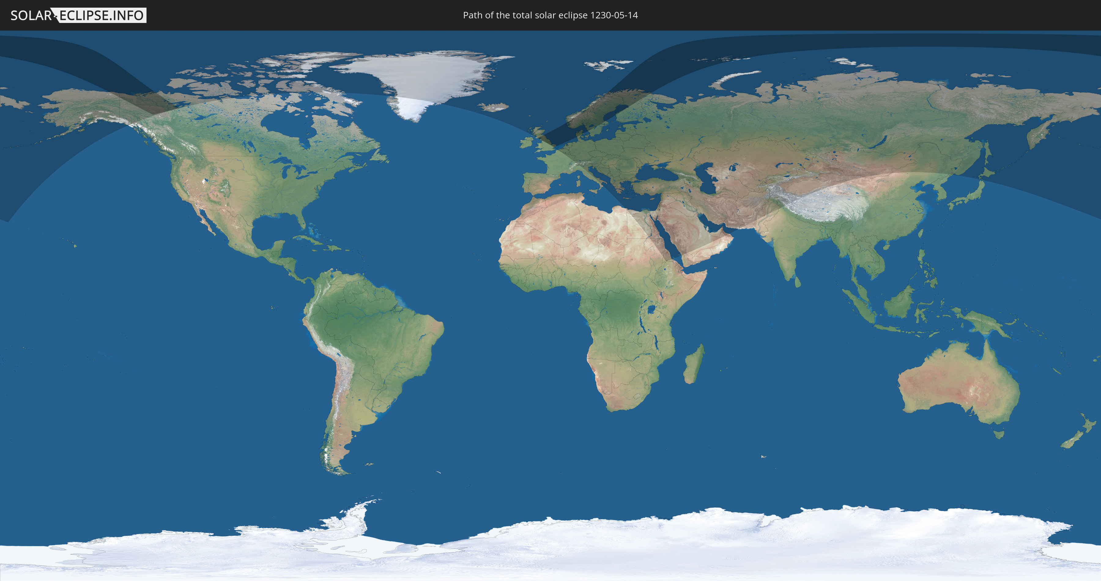
Die Sonnenfinsternis am 05/14/1230 kann man in 79 Ländern als partielle Sonnenfinsternis beobachten.
Der Finsternispfad verläuft durch 9 Länder. Nur in diesen Ländern ist sie als total Sonnenfinsternis zu sehen.
In den folgenden Ländern ist die Sonnenfinsternis total zu sehen
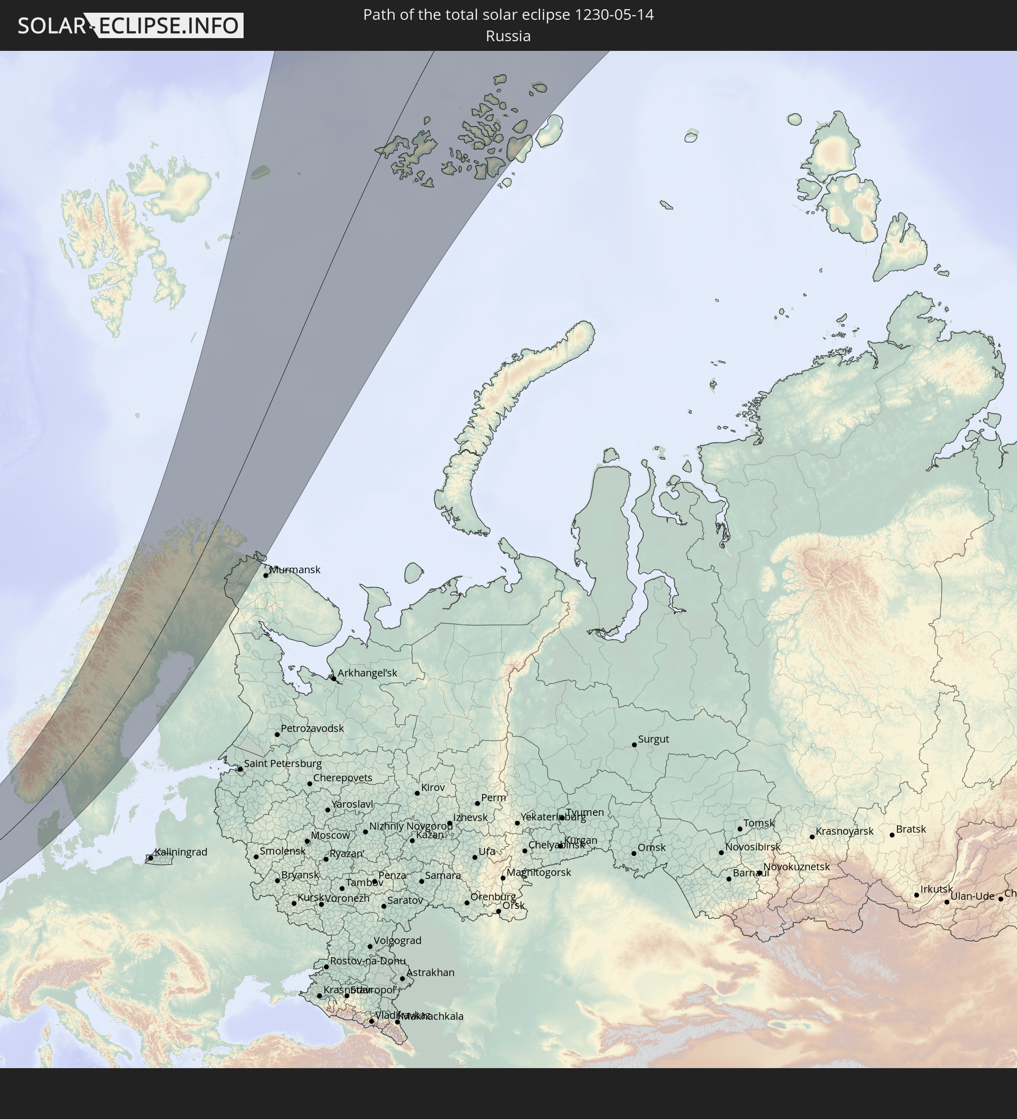 Russia
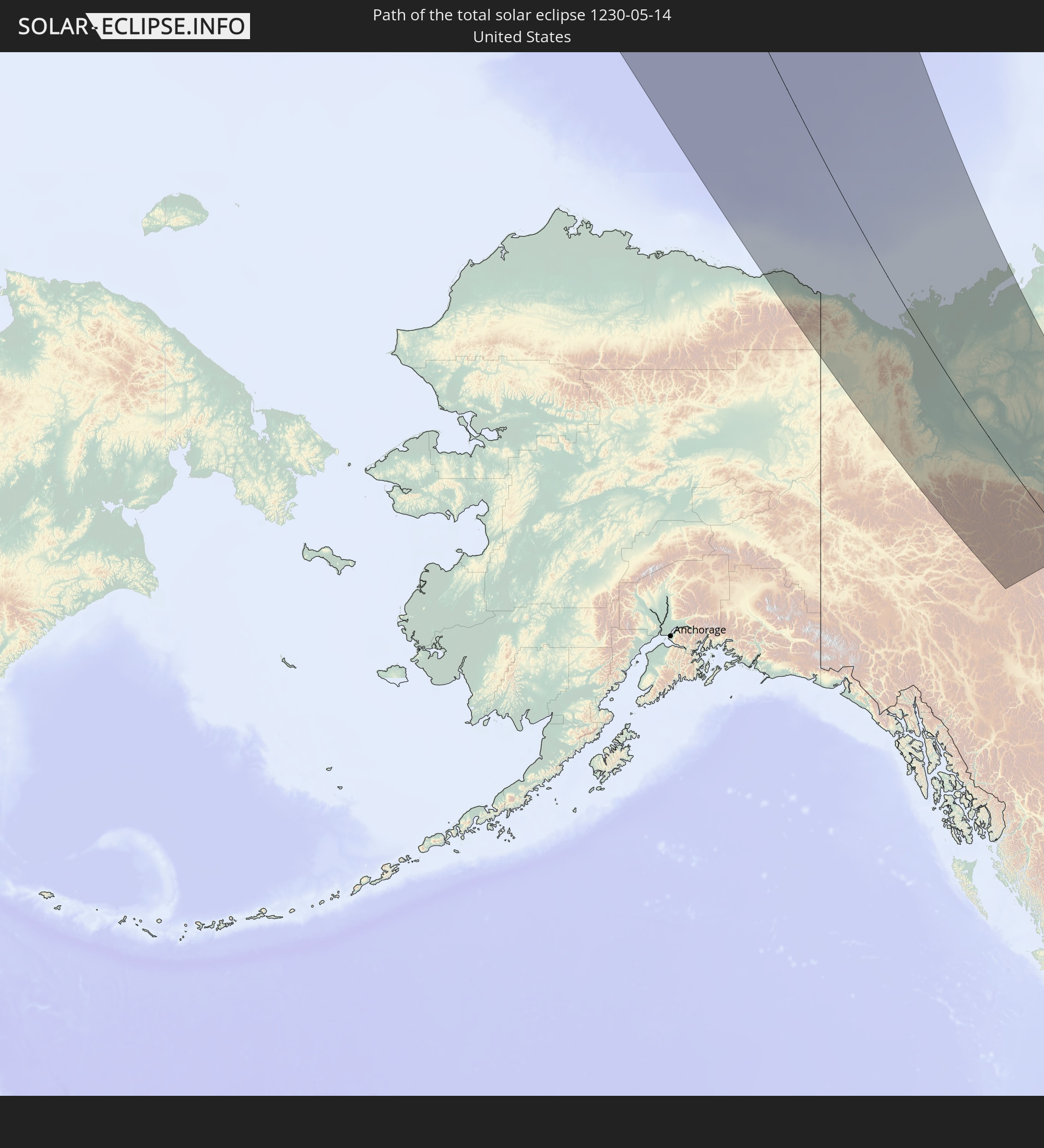 United States
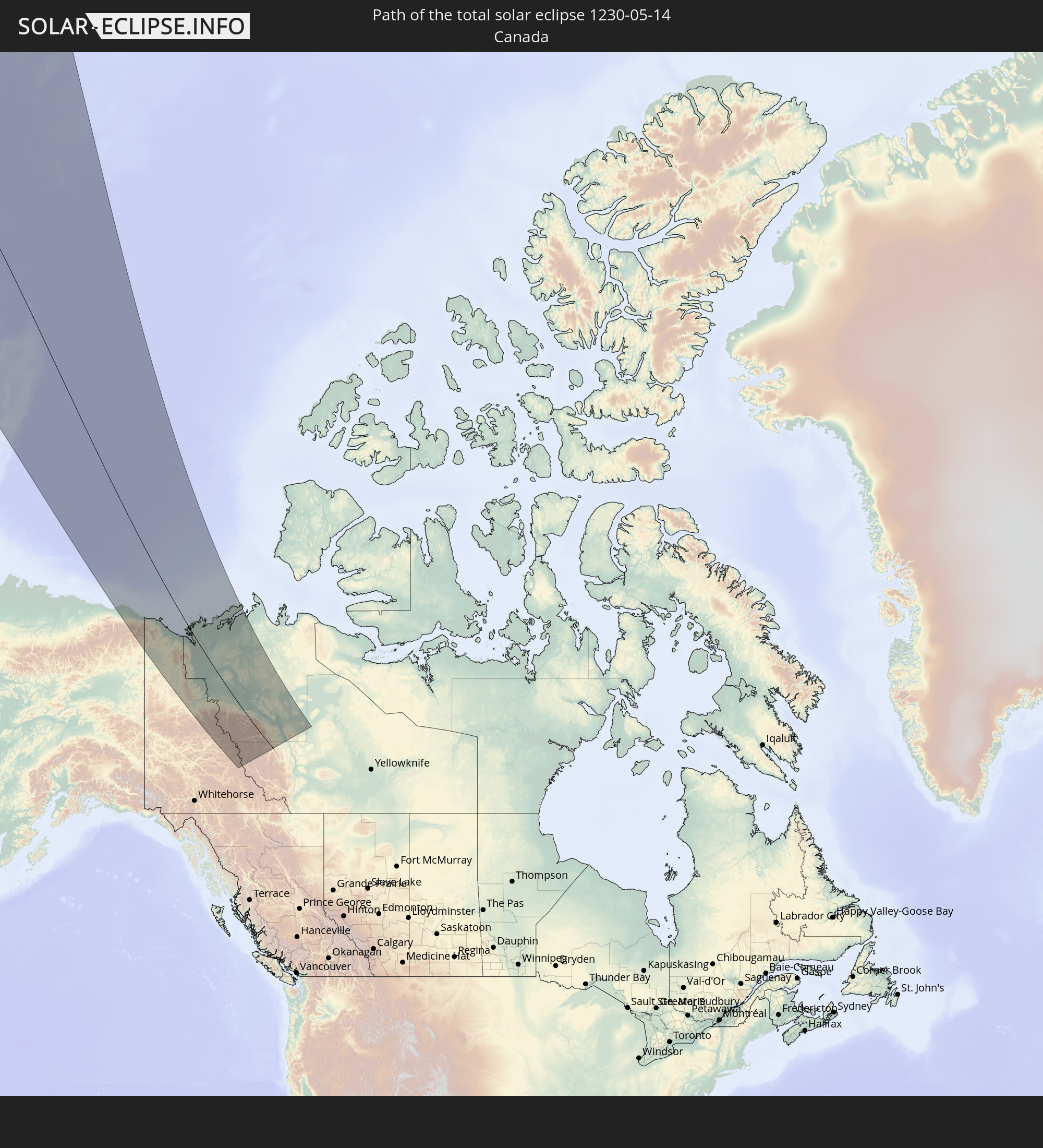 Canada
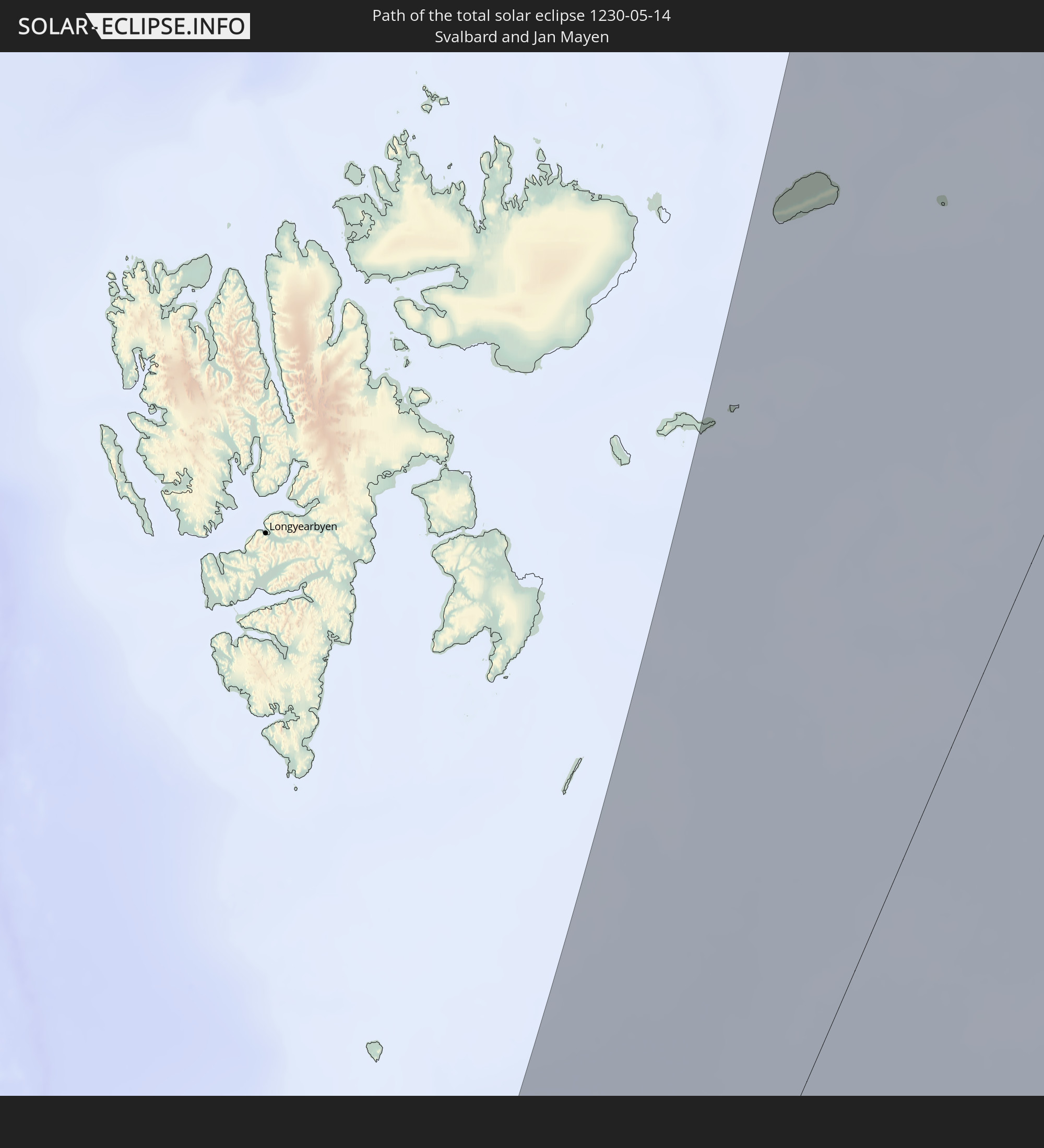 Svalbard and Jan Mayen
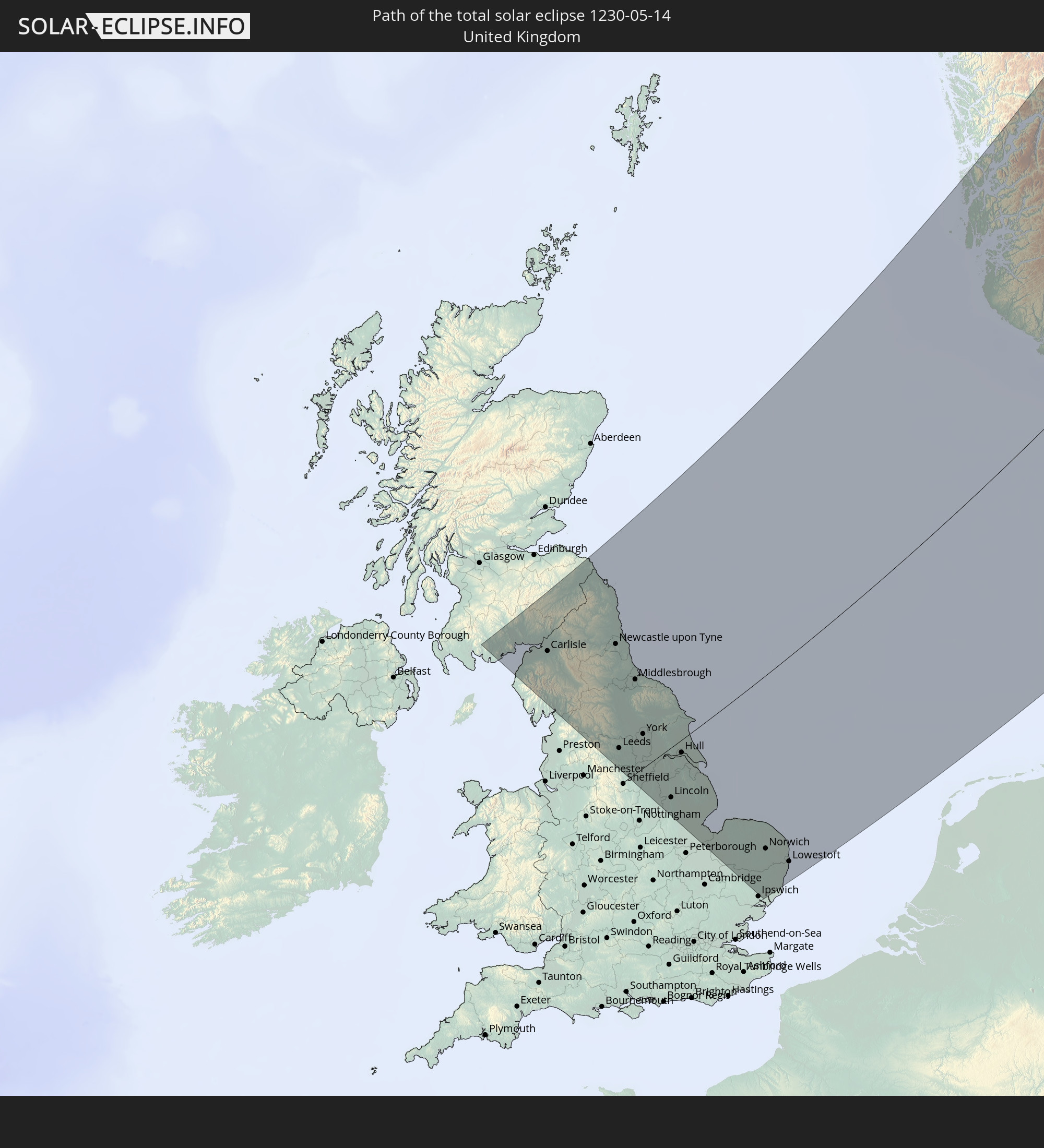 United Kingdom
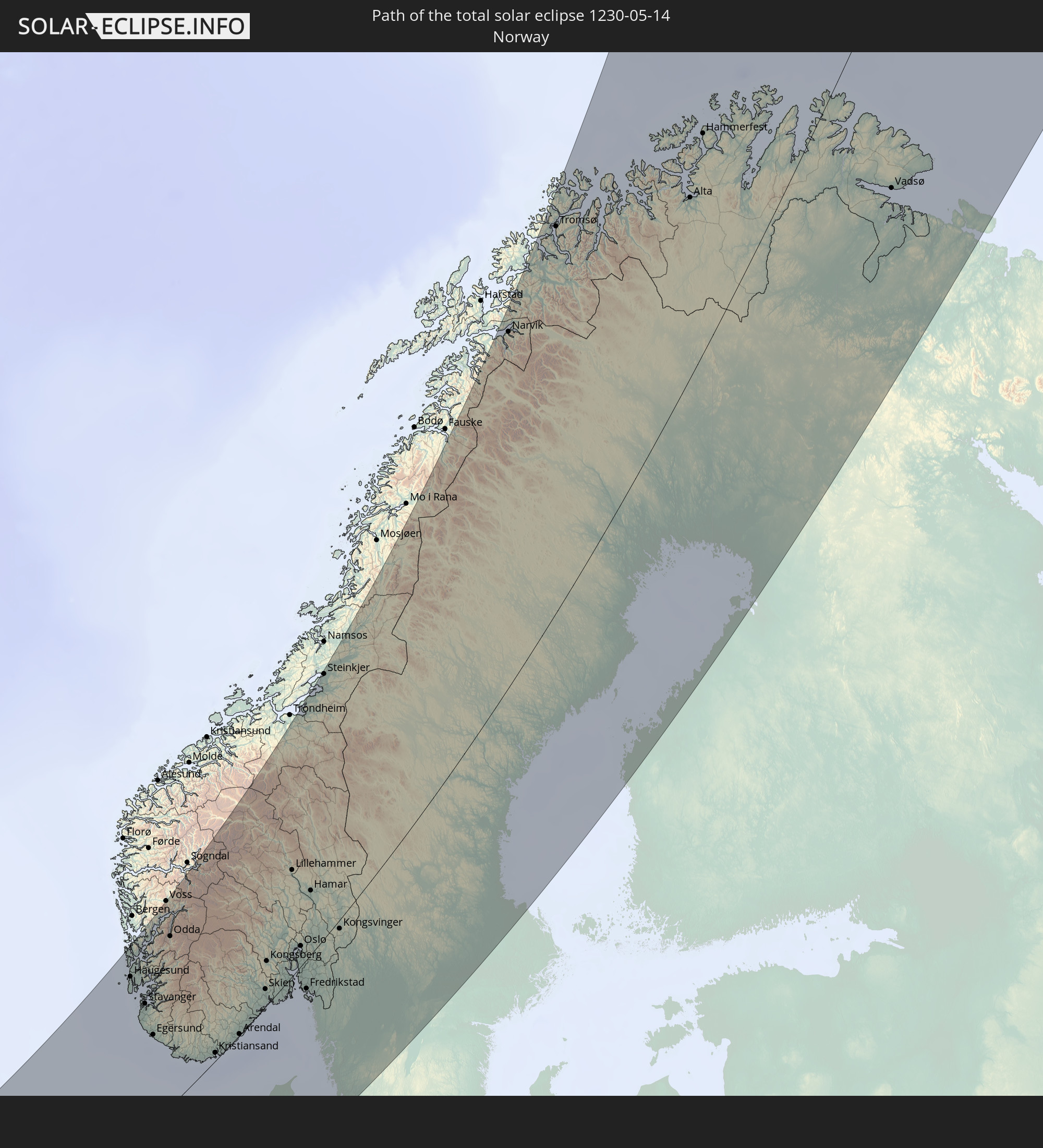 Norway
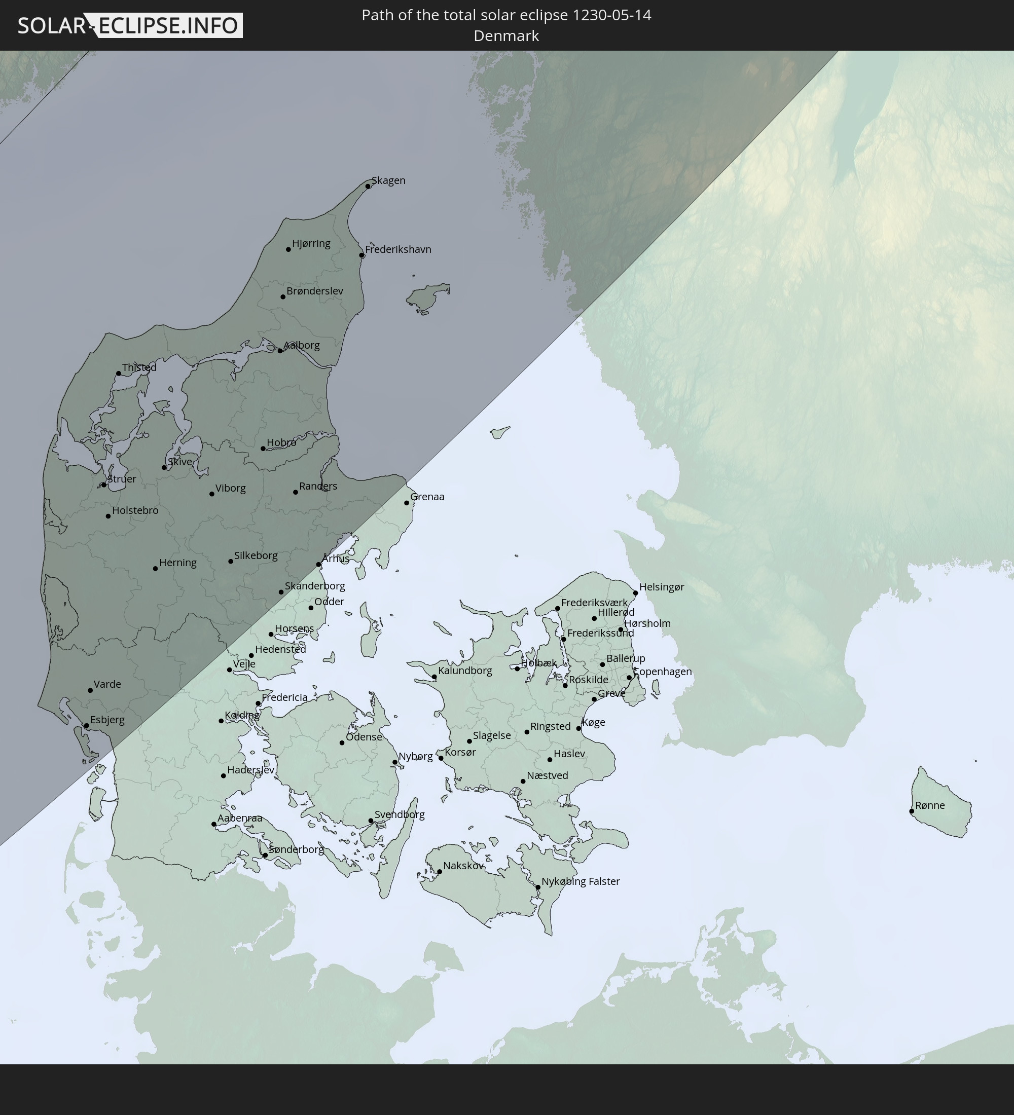 Denmark
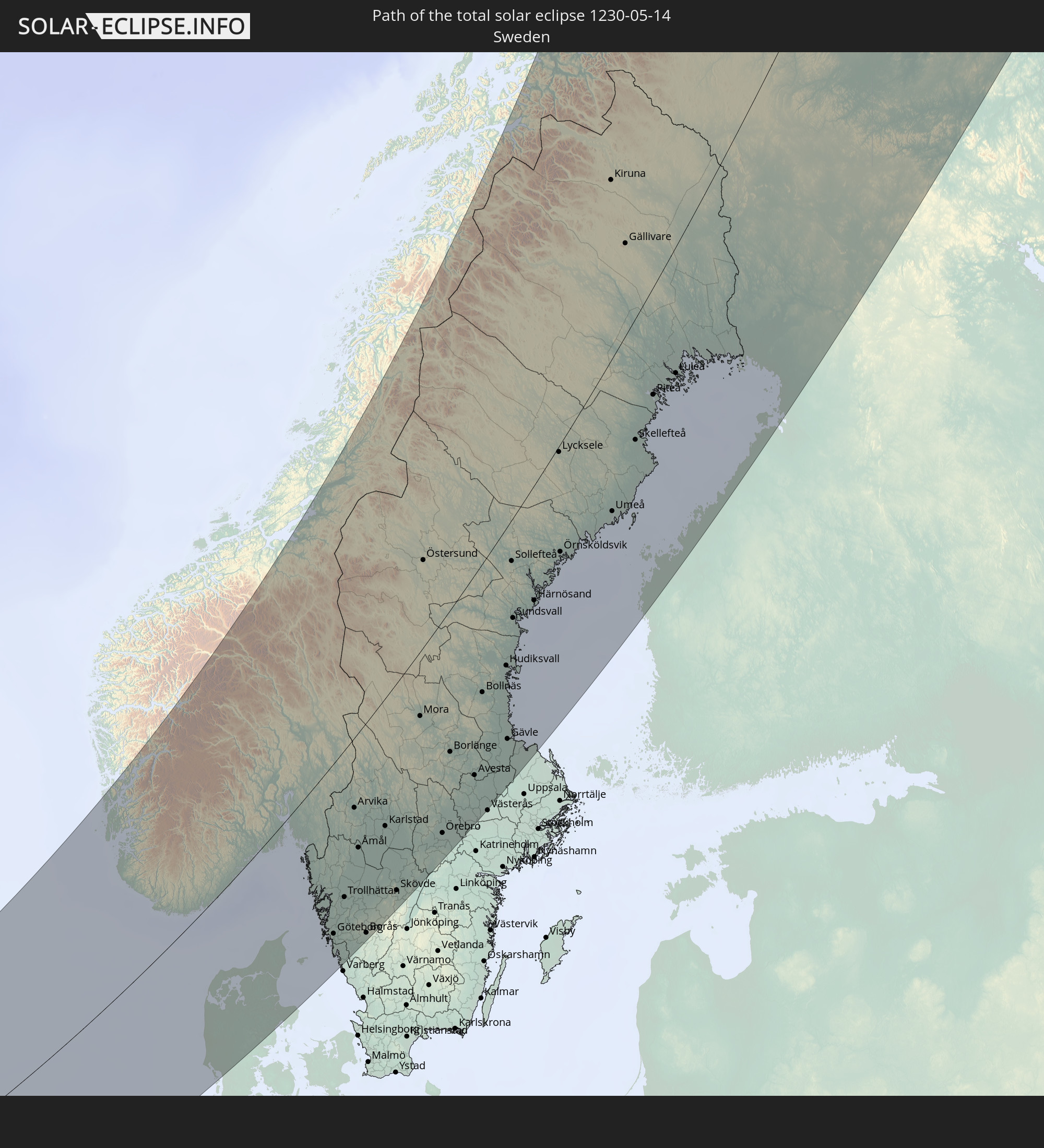 Sweden
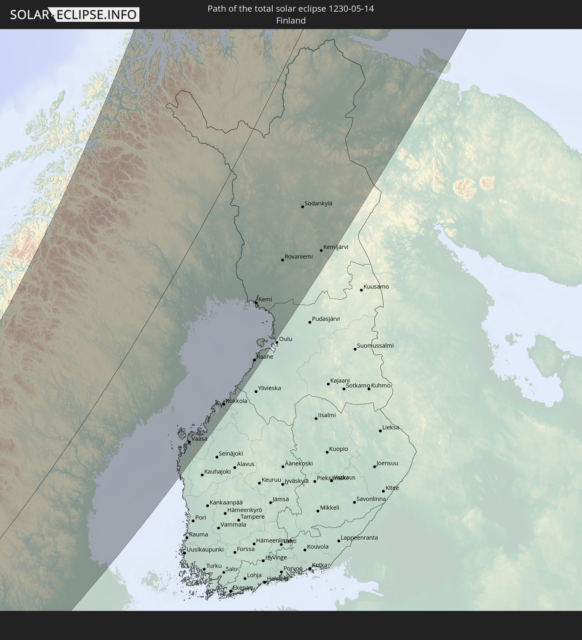 Finland
In den folgenden Ländern ist die Sonnenfinsternis partiell zu sehen
 Russia
 United States
 United States Minor Outlying Islands
 Canada
 Greenland
 Iceland
 Svalbard and Jan Mayen
 United Kingdom
 Faroe Islands
 France
 Belgium
 Netherlands
 Norway
 Luxembourg
 Germany
 Switzerland
 Italy
Italy
 Denmark
 Libya
Libya
 Liechtenstein
 Austria
 Sweden
 Czechia
 San Marino
 Slovenia
 Croatia
 Poland
 Bosnia and Herzegovina
 Hungary
 Slovakia
 Montenegro
 Serbia
 Albania
 Åland Islands
 Greece
 Romania
 Republic of Macedonia
 Finland
 Lithuania
 Latvia
 Estonia
 Sudan
Sudan
 Ukraine
 Bulgaria
 Belarus
 Egypt
Egypt
 Turkey
 Moldova
 Cyprus
 Ethiopia
 State of Palestine
 Israel
 Saudi Arabia
 Jordan
 Lebanon
 Syria
Syria
 Eritrea
 Iraq
Iraq
 Georgia
 Yemen
Yemen
 Armenia
 Iran
Iran
 Azerbaijan
 Kazakhstan
 Kuwait
 Bahrain
 Qatar
Qatar
 United Arab Emirates
 Oman
Oman
 Turkmenistan
 Uzbekistan
 Afghanistan
 Pakistan
 Tajikistan
 India
India
 Kyrgyzstan
 China
China
 Mongolia
 Japan
Japan
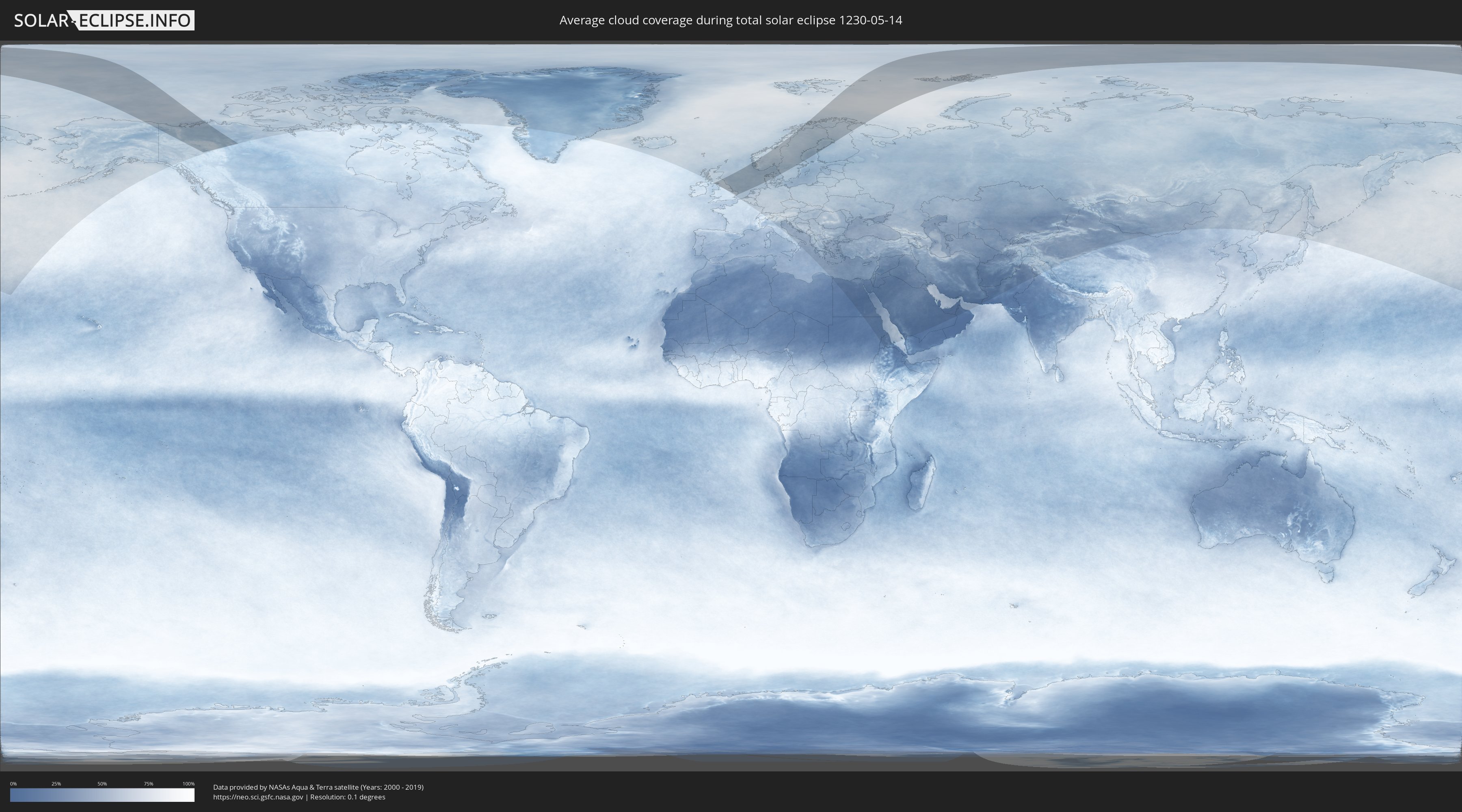
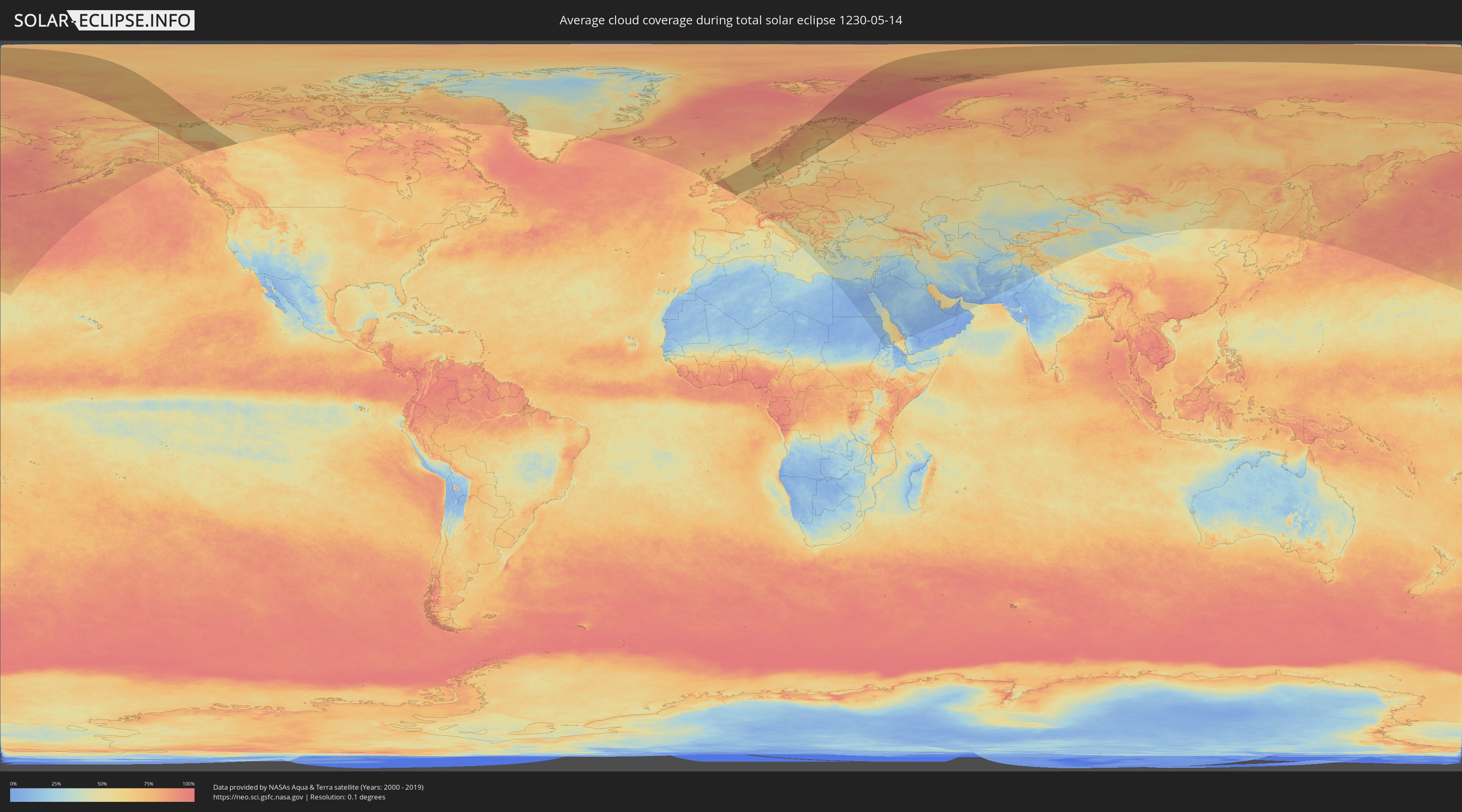
How will be the weather during the total solar eclipse on 05/14/1230?
Where is the best place to see the total solar eclipse of 05/14/1230?
The following maps show the average cloud coverage for the day of the total solar eclipse.
With the help of these maps, it is possible to find the place along the eclipse path, which has the best
chance of a cloudless sky.
Nevertheless, you should consider local circumstances and inform about the weather of your chosen
observation site.
The data is provided by NASAs satellites
AQUA and TERRA.
The cloud maps are averaged over a period of 19 years (2000 - 2019).
Detailed country maps
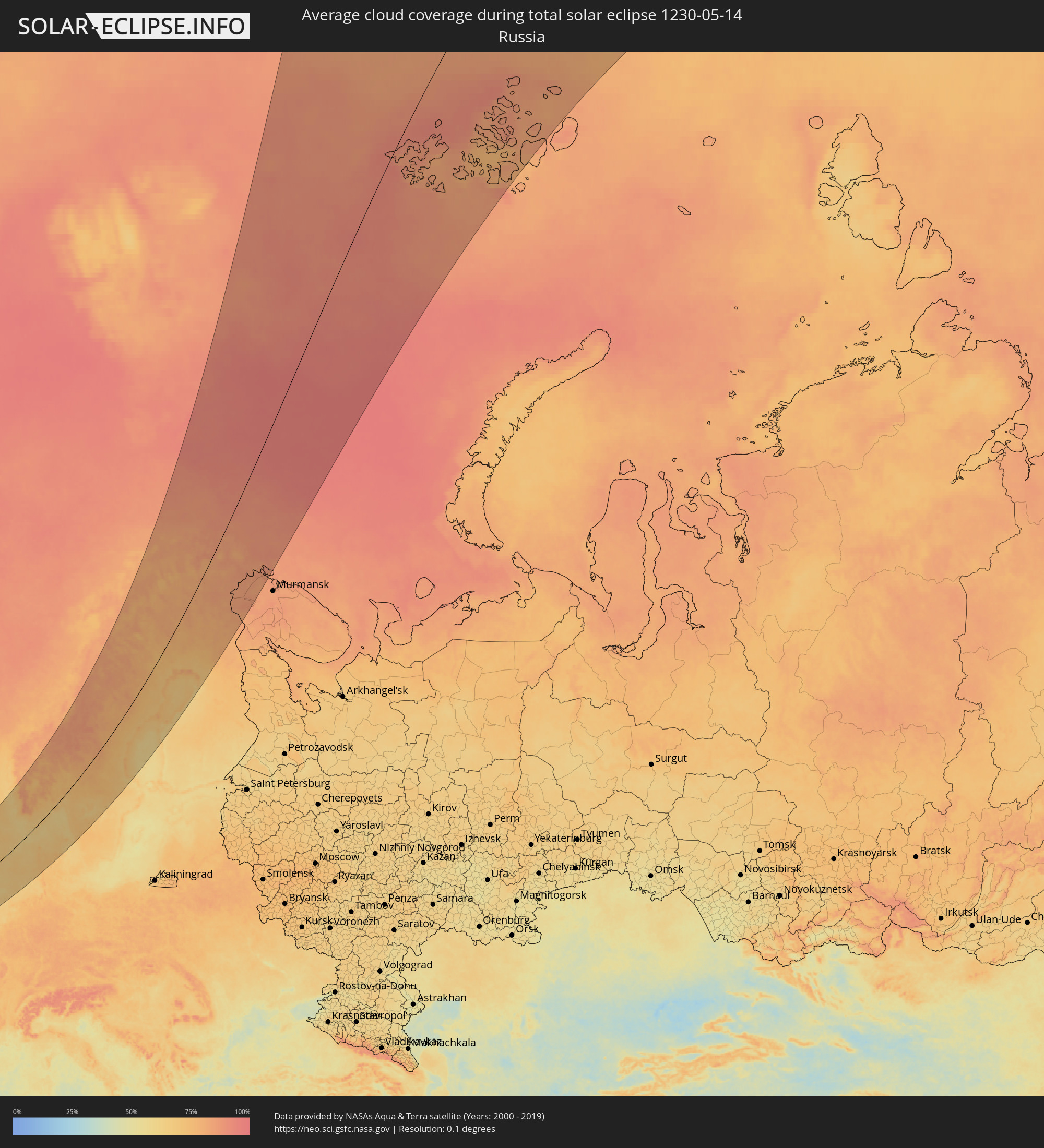 Russia
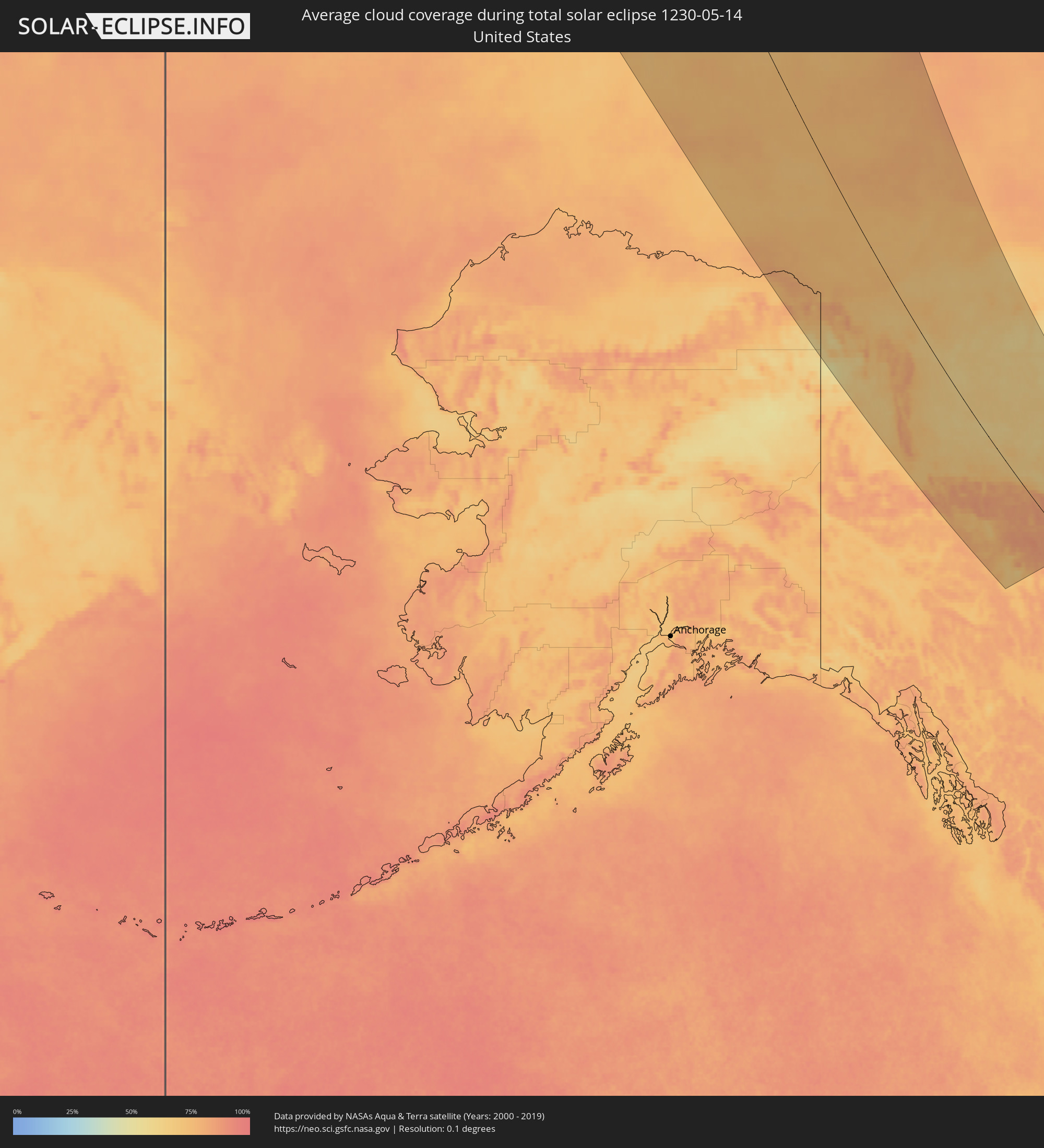 United States
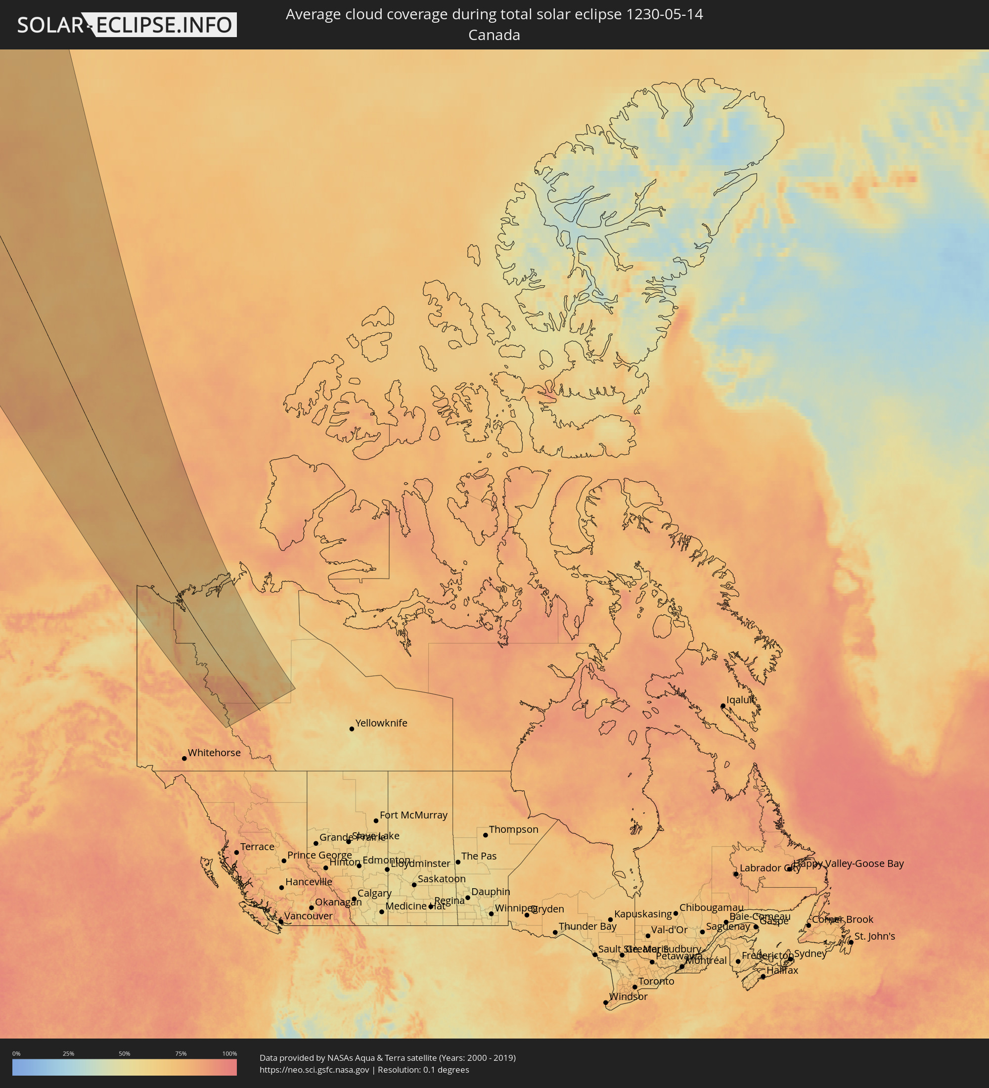 Canada
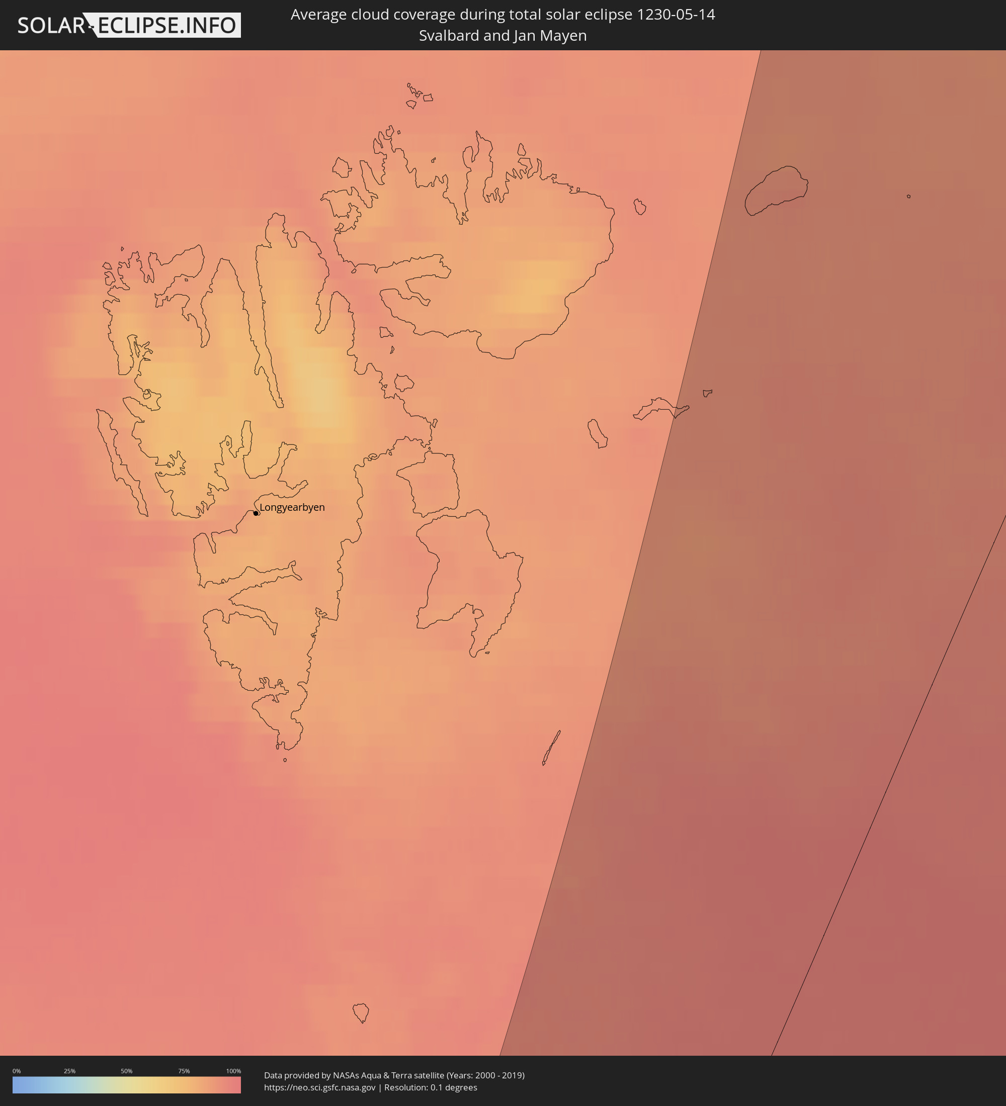 Svalbard and Jan Mayen
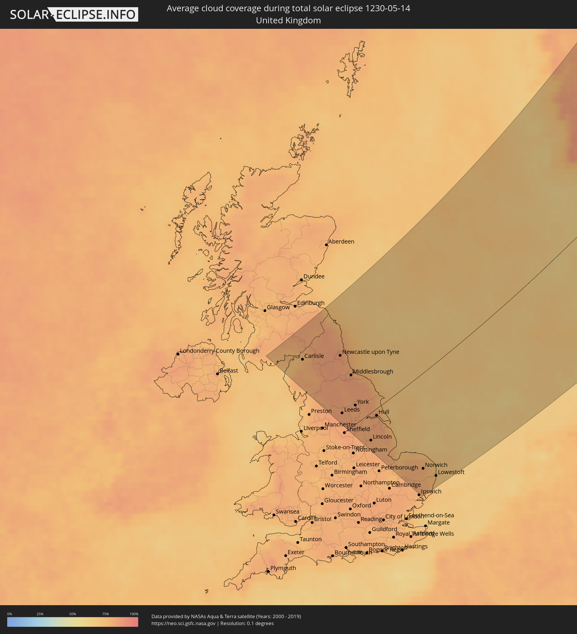 United Kingdom
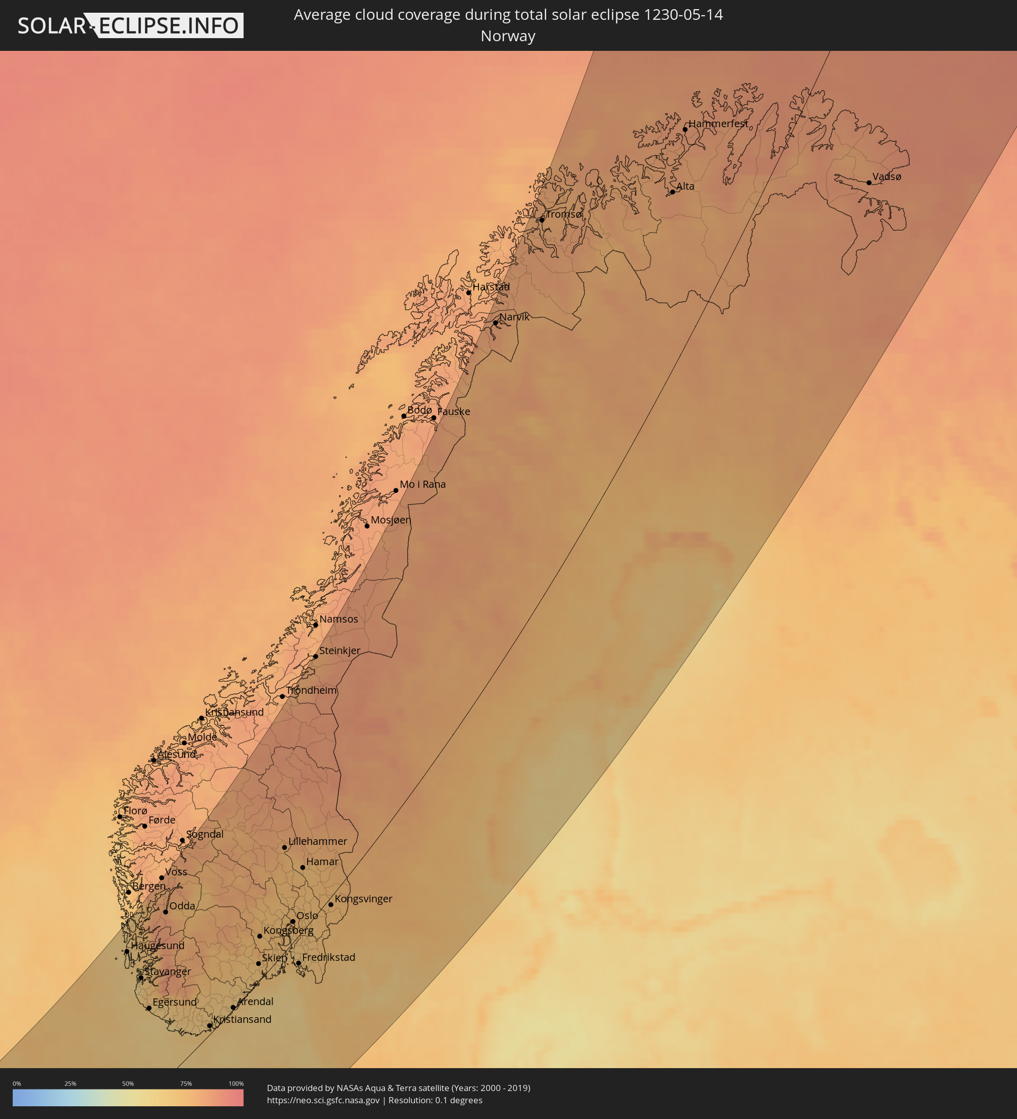 Norway
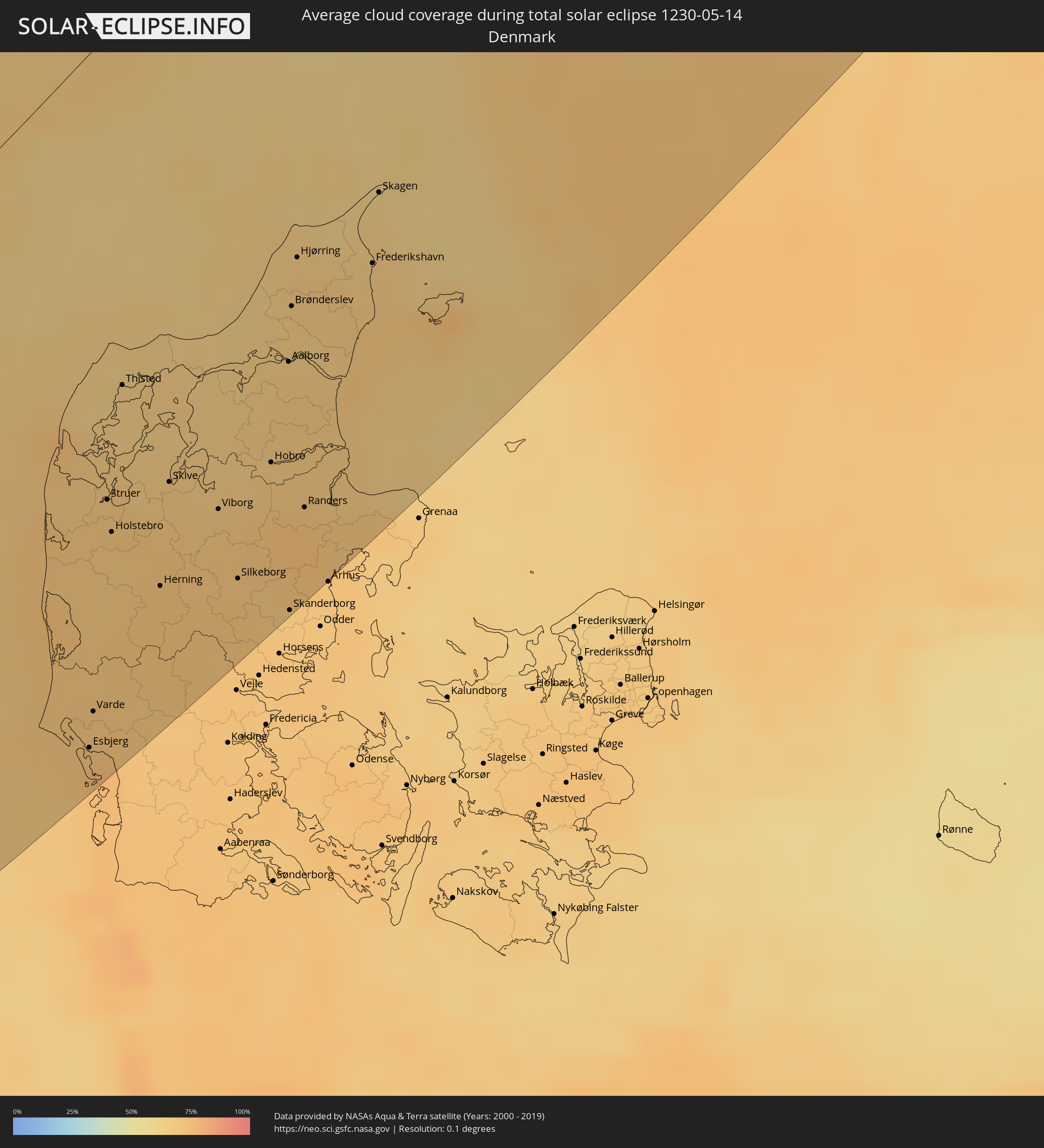 Denmark
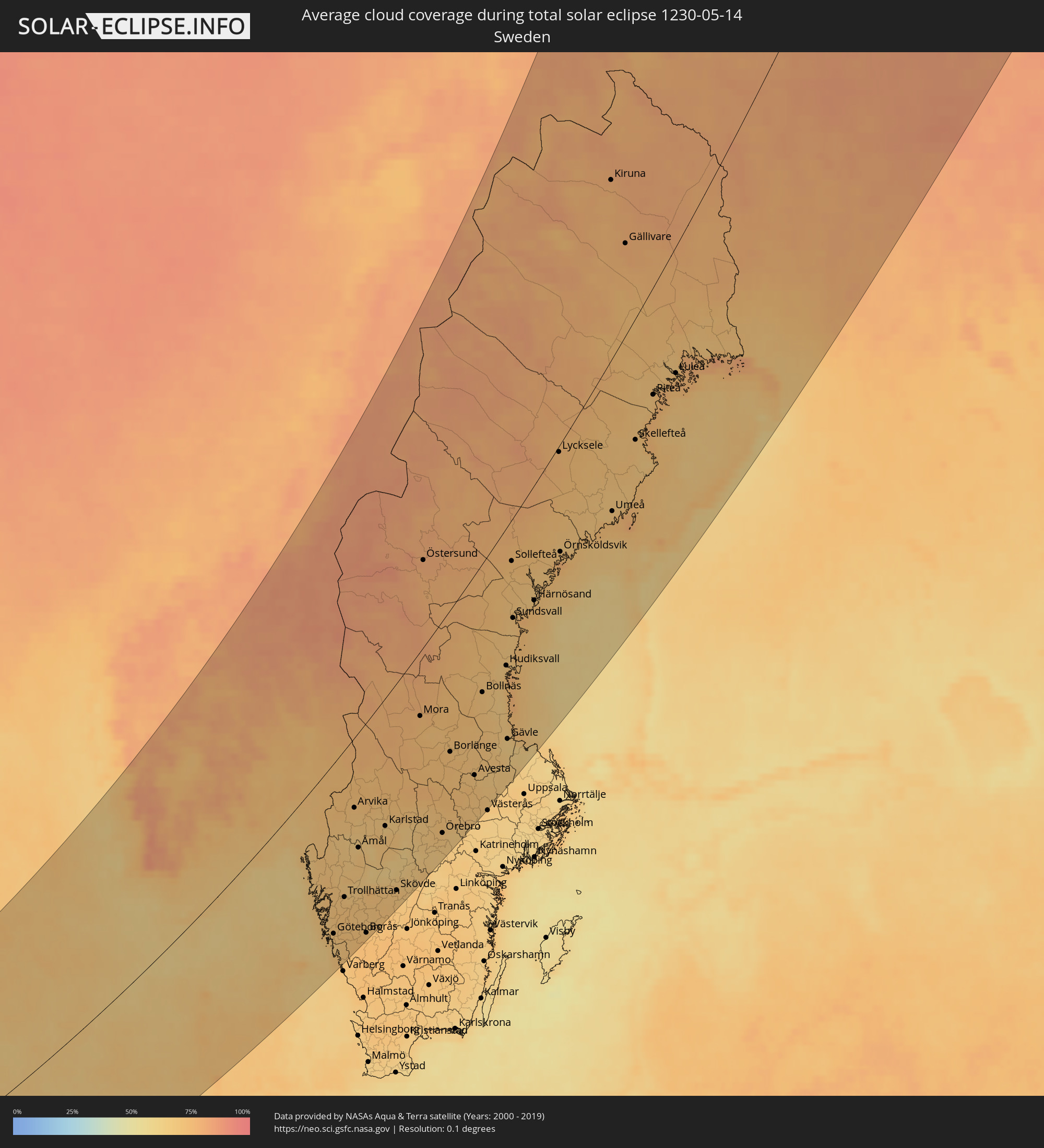 Sweden
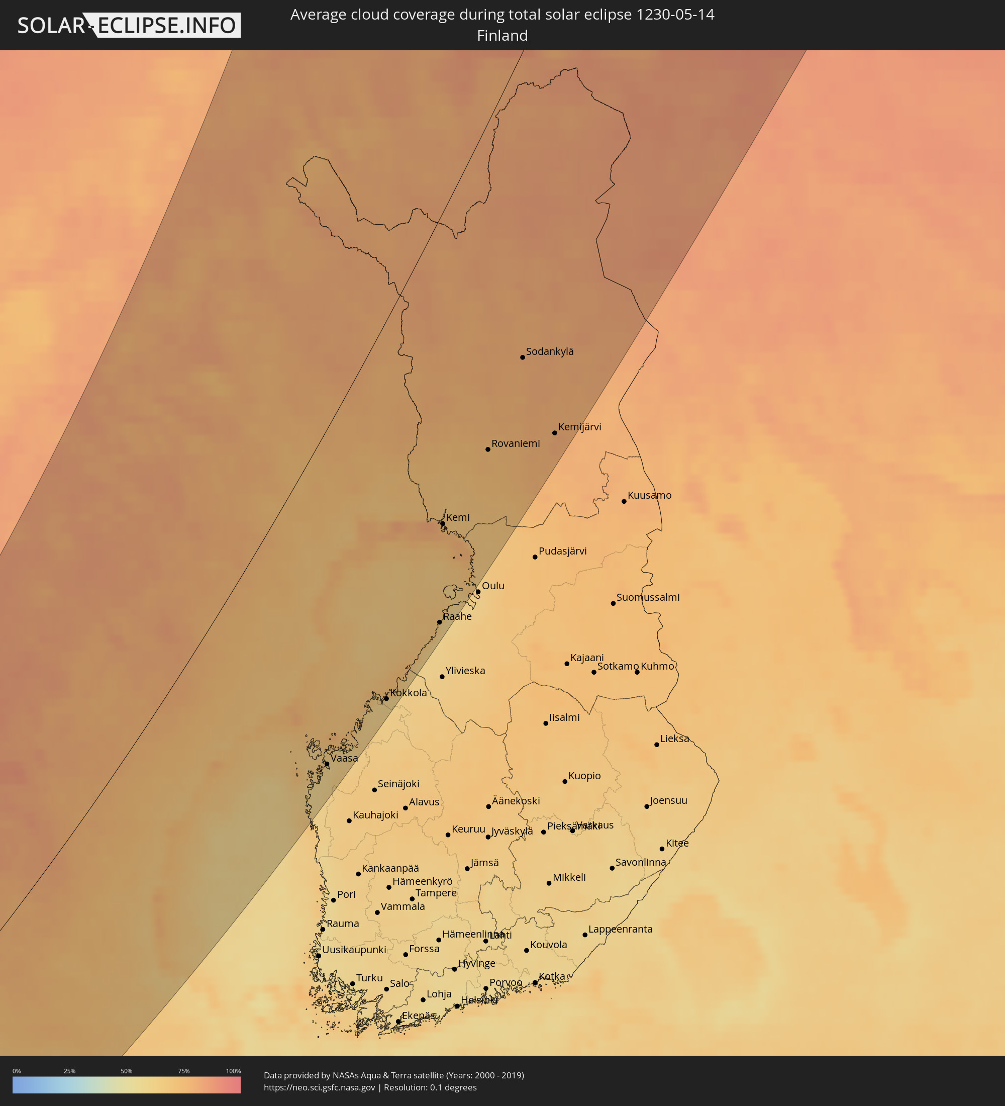 Finland
Cities inside the path of the eclipse
The following table shows all locations with a population of more than 5,000 inside the eclipse path. Cities which have more than 100,000 inhabitants are marked bold. A click at the locations opens a detailed map.
| City | Type | Eclipse duration | Local time of max. eclipse | Distance to central line | Ø Cloud coverage |
|
Workington, England
|
total | - | 04:05:03 UTC+00:00 | 194 km | 71% |
|
Carlisle, England
|
total | - | 04:05:03 UTC+00:00 | 191 km | 78% |
|
Kendal, England
|
total | - | 04:04:16 UTC+00:00 | 133 km | 78% |
|
Berwick-Upon-Tweed, England
|
total | - | 04:05:41 UTC+00:00 | 232 km | 74% |
|
Keighley, England
|
total | - | 04:03:18 UTC+00:00 | 59 km | 83% |
|
Halifax, England
|
total | - | 04:03:05 UTC+00:00 | 43 km | 84% |
|
Consett, England
|
total | - | 04:04:27 UTC+00:00 | 144 km | 84% |
|
Newcastle upon Tyne, England
|
total | - | 04:04:30 UTC+00:00 | 146 km | 84% |
|
Durham, England
|
total | - | 04:04:14 UTC+00:00 | 127 km | 84% |
|
Darlington, England
|
total | - | 04:03:55 UTC+00:00 | 104 km | 82% |
|
Leeds, England
|
total | - | 04:03:02 UTC+00:00 | 39 km | 83% |
|
Harrogate, England
|
total | - | 04:03:16 UTC+00:00 | 56 km | 83% |
|
Blyth, England
|
total | - | 04:04:38 UTC+00:00 | 155 km | 82% |
|
Barnsley, England
|
total | - | 04:02:42 UTC+00:00 | 14 km | 83% |
|
Sunderland, England
|
total | - | 04:04:18 UTC+00:00 | 131 km | 80% |
|
Rotherham, England
|
total | - | 04:02:29 UTC+00:00 | 2 km | 83% |
|
Peterlee, England
|
total | - | 04:04:06 UTC+00:00 | 116 km | 80% |
|
Pontefract, England
|
total | - | 04:02:47 UTC+00:00 | 20 km | 83% |
|
Middlesbrough, England
|
total | - | 04:03:49 UTC+00:00 | 96 km | 84% |
|
Doncaster, England
|
total | - | 04:02:29 UTC+00:00 | 2 km | 82% |
|
York, England
|
total | - | 04:02:59 UTC+00:00 | 35 km | 83% |
|
Retford, England
|
total | - | 04:02:09 UTC+00:00 | 28 km | 81% |
|
Scunthorpe, England
|
total | - | 04:02:19 UTC+00:00 | 16 km | 80% |
|
Lincoln, England
|
total | - | 04:01:50 UTC+00:00 | 52 km | 81% |
|
Scarborough, England
|
total | - | 04:03:03 UTC+00:00 | 37 km | 76% |
|
Hull, England
|
total | - | 04:02:22 UTC+00:00 | 13 km | 80% |
|
Bridlington, England
|
total | - | 04:02:42 UTC+00:00 | 12 km | 73% |
|
Spalding, England
|
total | - | 04:01:06 UTC+00:00 | 107 km | 78% |
|
Cleethorpes, England
|
total | - | 04:01:59 UTC+00:00 | 41 km | 77% |
|
Boston, England
|
total | - | 04:01:16 UTC+00:00 | 94 km | 79% |
|
King's Lynn, England
|
total | - | 04:00:47 UTC+00:00 | 131 km | 76% |
|
Thetford, England
|
total | - | 04:00:12 UTC+00:00 | 175 km | 80% |
|
Norwich, England
|
total | - | 04:00:11 UTC+00:00 | 178 km | 79% |
|
Lowestoft, England
|
total | - | 03:59:47 UTC+00:00 | 209 km | 70% |
|
Haugesund, Rogaland
|
total | - | 05:07:27 UTC+01:00 | 222 km | 61% |
|
Leirvik, Hordaland
|
total | - | 05:07:54 UTC+01:00 | 239 km | 71% |
|
Stavanger, Rogaland
|
total | - | 05:06:40 UTC+01:00 | 169 km | 63% |
|
Egersund, Rogaland
|
total | - | 05:05:51 UTC+01:00 | 119 km | 66% |
|
Mandal, Vest-Agder
|
total | - | 05:04:44 UTC+01:00 | 25 km | 68% |
|
Søgne, Vest-Agder
|
total | - | 05:04:43 UTC+01:00 | 16 km | 69% |
|
Kristiansand, Vest-Agder
|
total | - | 05:04:43 UTC+01:00 | 11 km | 67% |
|
Ringkøbing, Central Jutland
|
total | - | 05:01:44 UTC+01:00 | 163 km | 72% |
|
Lemvig, Central Jutland
|
total | - | 05:02:21 UTC+01:00 | 129 km | 68% |
|
Esbjerg, South Denmark
|
total | - | 05:00:48 UTC+01:00 | 223 km | 71% |
|
Varde, South Denmark
|
total | - | 05:01:00 UTC+01:00 | 211 km | 69% |
|
Skjern, Central Jutland
|
total | - | 05:01:27 UTC+01:00 | 185 km | 70% |
|
Struer, Central Jutland
|
total | - | 05:02:11 UTC+01:00 | 145 km | 70% |
|
Grimstad, Aust-Agder
|
total | - | 05:04:48 UTC+01:00 | 8 km | 68% |
|
Holstebro, Central Jutland
|
total | - | 05:01:59 UTC+01:00 | 157 km | 71% |
|
Thisted, North Denmark
|
total | - | 05:02:47 UTC+01:00 | 112 km | 65% |
|
Bramming, South Denmark
|
total | - | 05:00:43 UTC+01:00 | 233 km | 70% |
|
Arendal, Aust-Agder
|
total | - | 05:04:55 UTC+01:00 | 18 km | 67% |
|
Nykøbing Mors, North Denmark
|
total | - | 05:02:30 UTC+01:00 | 132 km | 65% |
|
Grindsted, South Denmark
|
total | - | 05:01:02 UTC+01:00 | 219 km | 71% |
|
Herning, Central Jutland
|
total | - | 05:01:33 UTC+01:00 | 190 km | 72% |
|
Skive, Central Jutland
|
total | - | 05:02:07 UTC+01:00 | 158 km | 68% |
|
Brande, Central Jutland
|
total | - | 05:01:13 UTC+01:00 | 212 km | 71% |
|
Ikast, Central Jutland
|
total | - | 05:01:29 UTC+01:00 | 198 km | 71% |
|
Viborg, Central Jutland
|
total | - | 05:01:50 UTC+01:00 | 182 km | 69% |
|
Aars, North Denmark
|
total | - | 05:02:18 UTC+01:00 | 159 km | 67% |
|
Silkeborg, Central Jutland
|
total | - | 05:01:23 UTC+01:00 | 211 km | 70% |
|
Skien, Telemark
|
total | - | 05:05:44 UTC+01:00 | 22 km | 69% |
|
Kongsberg, Buskerud
|
total | - | 05:06:23 UTC+01:00 | 54 km | 72% |
|
Bjerringbro, Central Jutland
|
total | - | 05:01:38 UTC+01:00 | 200 km | 71% |
|
Hobro, North Denmark
|
total | - | 05:01:58 UTC+01:00 | 184 km | 69% |
|
Støvring, North Denmark
|
total | - | 05:02:18 UTC+01:00 | 166 km | 69% |
|
Aalborg, North Denmark
|
total | - | 05:02:30 UTC+01:00 | 157 km | 68% |
|
Skanderborg, Central Jutland
|
total | - | 05:01:04 UTC+01:00 | 238 km | 70% |
|
Nørresundby, North Denmark
|
total | - | 05:02:30 UTC+01:00 | 158 km | 68% |
|
Brønderslev, North Denmark
|
total | - | 05:02:49 UTC+01:00 | 140 km | 68% |
|
Hirtshals, North Denmark
|
total | - | 05:03:16 UTC+01:00 | 116 km | 65% |
|
Hjørring, North Denmark
|
total | - | 05:03:05 UTC+01:00 | 127 km | 67% |
|
Randers, Central Jutland
|
total | - | 05:01:38 UTC+01:00 | 209 km | 71% |
|
Hadsten, Central Jutland
|
total | - | 05:01:26 UTC+01:00 | 220 km | 73% |
|
Hinnerup, Central Jutland
|
total | - | 05:01:20 UTC+01:00 | 226 km | 73% |
|
Drammen, Buskerud
|
total | - | 05:06:20 UTC+01:00 | 38 km | 73% |
|
Sandefjord, Vestfold
|
total | - | 05:05:26 UTC+01:00 | 10 km | 68% |
|
Lystrup, Central Jutland
|
total | - | 05:01:14 UTC+01:00 | 235 km | 71% |
|
Hønefoss, Buskerud
|
total | - | 05:06:57 UTC+01:00 | 64 km | 70% |
|
Tønsberg, Vestfold
|
total | - | 05:05:34 UTC+01:00 | 20 km | 68% |
|
Lillehammer, Oppland
|
total | - | 05:08:19 UTC+01:00 | 121 km | 75% |
|
Sæby, North Denmark
|
total | - | 05:02:43 UTC+01:00 | 160 km | 69% |
|
Frederikshavn, North Denmark
|
total | - | 05:02:52 UTC+01:00 | 153 km | 67% |
|
Skagen, North Denmark
|
total | - | 05:03:15 UTC+01:00 | 133 km | 63% |
|
Moss, Østfold
|
total | - | 05:05:45 UTC+01:00 | 9 km | 67% |
|
Nesoddtangen, Akershus
|
total | - | 05:06:23 UTC+01:00 | 24 km | 75% |
|
Gjøvik, Oppland
|
total | - | 05:07:46 UTC+01:00 | 88 km | 73% |
|
Oslo, Oslo
|
total | - | 05:06:26 UTC+01:00 | 25 km | 75% |
|
Ski, Akershus
|
total | - | 05:06:07 UTC+01:00 | 9 km | 70% |
|
Stjørdalshalsen, Nord-Trøndelag
|
total | - | 05:11:48 UTC+01:00 | 249 km | 79% |
|
Fredrikstad, Østfold
|
total | - | 05:05:21 UTC+01:00 | 34 km | 69% |
|
Lillestrøm, Akershus
|
total | - | 05:06:25 UTC+01:00 | 25 km | 73% |
|
Hamar, Hedmark
|
total | - | 05:07:40 UTC+01:00 | 72 km | 72% |
|
Askim, Østfold
|
total | - | 05:05:49 UTC+01:00 | 19 km | 69% |
|
Jessheim, Akershus
|
total | - | 05:06:39 UTC+01:00 | 22 km | 72% |
|
Halden, Østfold
|
total | - | 05:05:04 UTC+01:00 | 61 km | 70% |
|
Steinkjer, Nord-Trøndelag
|
total | - | 05:12:31 UTC+01:00 | 258 km | 78% |
|
Elverum, Hedmark
|
total | - | 05:07:40 UTC+01:00 | 57 km | 75% |
|
Uddevalla, Västra Götaland
|
total | - | 05:03:46 UTC+01:00 | 143 km | 70% |
|
Göteborg, Västra Götaland
|
total | - | 05:02:49 UTC+01:00 | 193 km | 70% |
|
Kungälv, Västra Götaland
|
total | - | 05:03:03 UTC+01:00 | 181 km | 70% |
|
Kongsvinger, Hedmark
|
total | - | 05:06:30 UTC+01:00 | 16 km | 73% |
|
Kungsbacka, Halland
|
total | - | 05:02:27 UTC+01:00 | 215 km | 68% |
|
Lerum, Västra Götaland
|
total | - | 05:02:49 UTC+01:00 | 201 km | 71% |
|
Trollhättan, Västra Götaland
|
total | - | 05:03:34 UTC+01:00 | 162 km | 70% |
|
Alingsås, Västra Götaland
|
total | - | 05:02:58 UTC+01:00 | 200 km | 71% |
|
Kinna, Västra Götaland
|
total | - | 05:02:18 UTC+01:00 | 239 km | 73% |
|
Borås, Västra Götaland
|
total | - | 05:02:33 UTC+01:00 | 233 km | 72% |
|
Lidköping, Västra Götaland
|
total | - | 05:03:39 UTC+01:00 | 184 km | 68% |
|
Skara, Västra Götaland
|
total | - | 05:03:24 UTC+01:00 | 205 km | 70% |
|
Karlstad, Värmland
|
total | - | 05:04:53 UTC+01:00 | 134 km | 66% |
|
Falköping, Västra Götaland
|
total | - | 05:03:03 UTC+01:00 | 225 km | 71% |
|
Mariestad, Västra Götaland
|
total | - | 05:03:47 UTC+01:00 | 197 km | 63% |
|
Skövde, Västra Götaland
|
total | - | 05:03:18 UTC+01:00 | 221 km | 69% |
|
Kristinehamn, Värmland
|
total | - | 05:04:37 UTC+01:00 | 164 km | 66% |
|
Karlskoga, Örebro
|
total | - | 05:04:32 UTC+01:00 | 180 km | 68% |
|
Östersund, Jämtland
|
total | - | 05:10:32 UTC+01:00 | 77 km | 81% |
|
Örebro, Örebro
|
total | - | 05:04:17 UTC+01:00 | 213 km | 70% |
|
Borlänge, Dalarna
|
total | - | 05:06:07 UTC+01:00 | 136 km | 73% |
|
Falun, Dalarna
|
total | - | 05:06:15 UTC+01:00 | 136 km | 71% |
|
Köping, Västmanland
|
total | - | 05:04:28 UTC+01:00 | 230 km | 70% |
|
Sandviken, Gävleborg
|
total | - | 05:06:02 UTC+01:00 | 183 km | 67% |
|
Hudiksvall, Gävleborg
|
total | - | 05:07:44 UTC+01:00 | 123 km | 69% |
|
Gävle, Gävleborg
|
total | - | 05:06:03 UTC+01:00 | 195 km | 65% |
|
Sundsvall, Västernorrland
|
total | - | 05:08:46 UTC+01:00 | 86 km | 70% |
|
Narvik, Nordland
|
total | - | 05:18:45 UTC+01:00 | 245 km | 83% |
|
Härnösand, Västernorrland
|
total | - | 05:09:03 UTC+01:00 | 97 km | 70% |
|
Örnsköldsvik, Västernorrland
|
total | - | 05:10:00 UTC+01:00 | 86 km | 70% |
|
Tromsø, Troms
|
total | - | 05:20:40 UTC+01:00 | 240 km | 79% |
|
Kiruna, Norrbotten
|
total | - | 05:17:29 UTC+01:00 | 112 km | 79% |
|
Umeå, Västerbotten
|
total | - | 05:10:40 UTC+01:00 | 117 km | 69% |
|
Skellefteå, Västerbotten
|
total | - | 05:12:08 UTC+01:00 | 87 km | 70% |
|
Piteå, Norrbotten
|
total | - | 05:13:02 UTC+01:00 | 74 km | 71% |
|
Malax, Ostrobothnia
|
total | - | 05:48:51 UTC+01:39 | 226 km | 61% |
|
Vaasa, Ostrobothnia
|
total | - | 05:49:06 UTC+01:39 | 217 km | 61% |
|
Korsholm, Ostrobothnia
|
total | - | 05:49:07 UTC+01:39 | 219 km | 62% |
|
Boden, Norrbotten
|
total | - | 05:13:53 UTC+01:00 | 55 km | 70% |
|
Laihia, Ostrobothnia
|
total | - | 05:48:51 UTC+01:39 | 241 km | 65% |
|
Luleå, Norrbotten
|
total | - | 05:13:25 UTC+01:00 | 85 km | 72% |
|
Nykarleby, Ostrobothnia
|
total | - | 05:49:43 UTC+01:39 | 227 km | 62% |
|
Pedersöre, Ostrobothnia
|
total | - | 05:49:55 UTC+01:39 | 225 km | 61% |
|
Jakobstad, Ostrobothnia
|
total | - | 05:49:57 UTC+01:39 | 224 km | 61% |
|
Kronoby, Ostrobothnia
|
total | - | 05:50:01 UTC+01:39 | 234 km | 62% |
|
Kokkola, Central Ostrobothnia
|
total | - | 05:50:11 UTC+01:39 | 231 km | 61% |
|
Alta, Finnmark Fylke
|
total | - | 05:20:57 UTC+01:00 | 103 km | 81% |
|
Ylitornio, Lapland
|
total | - | 05:54:22 UTC+01:39 | 103 km | 72% |
|
Kalajoki, Northern Ostrobothnia
|
total | - | 05:50:49 UTC+01:39 | 238 km | 61% |
|
Tornio, Lapland
|
total | - | 05:53:33 UTC+01:39 | 148 km | 81% |
|
Raahe, Northern Ostrobothnia
|
total | - | 05:51:31 UTC+01:39 | 232 km | 63% |
|
Keminmaa, Lapland
|
total | - | 05:53:27 UTC+01:39 | 165 km | 75% |
|
Kemi, Lapland
|
total | - | 05:53:20 UTC+01:39 | 170 km | 77% |
|
Kittilä, Lapland
|
total | - | 05:56:40 UTC+01:39 | 73 km | 78% |
|
Haukipudas, Northern Ostrobothnia
|
total | - | 05:52:19 UTC+01:39 | 234 km | 64% |
|
Ii, Northern Ostrobothnia
|
total | - | 05:52:34 UTC+01:39 | 227 km | 66% |
|
Rovaniemi, Lapland
|
total | - | 05:54:36 UTC+01:39 | 169 km | 74% |
|
Sodankylä, Lapland
|
total | - | 05:56:11 UTC+01:39 | 149 km | 79% |
|
Inari, Lapland
|
total | - | 05:58:49 UTC+01:39 | 84 km | 84% |
|
Pyhäjärvi, Lapland
|
total | - | 05:55:34 UTC+01:39 | 192 km | 80% |
|
Kemijärvi, Lapland
|
total | - | 05:54:51 UTC+01:39 | 222 km | 79% |
|
Nikel, Murmansk
|
total | - | 06:50:13 UTC+02:30 | 166 km | 85% |
|
Zapolyarnyy, Murmansk
|
total | - | 06:50:15 UTC+02:30 | 186 km | 84% |