Totale Sonnenfinsternis vom 14.02.2306
| Wochentag: | Mittwoch |
| Maximale Dauer der Verfinsterung: | 03m49s |
| Maximale Breite des Finsternispfades: | 147 km |
| Saroszyklus: | 145 |
| Bedeckungsgrad: | 100% |
| Magnitude: | 1.0441 |
| Gamma: | 0.0394 |
Wo kann man die Sonnenfinsternis vom 14.02.2306 sehen?
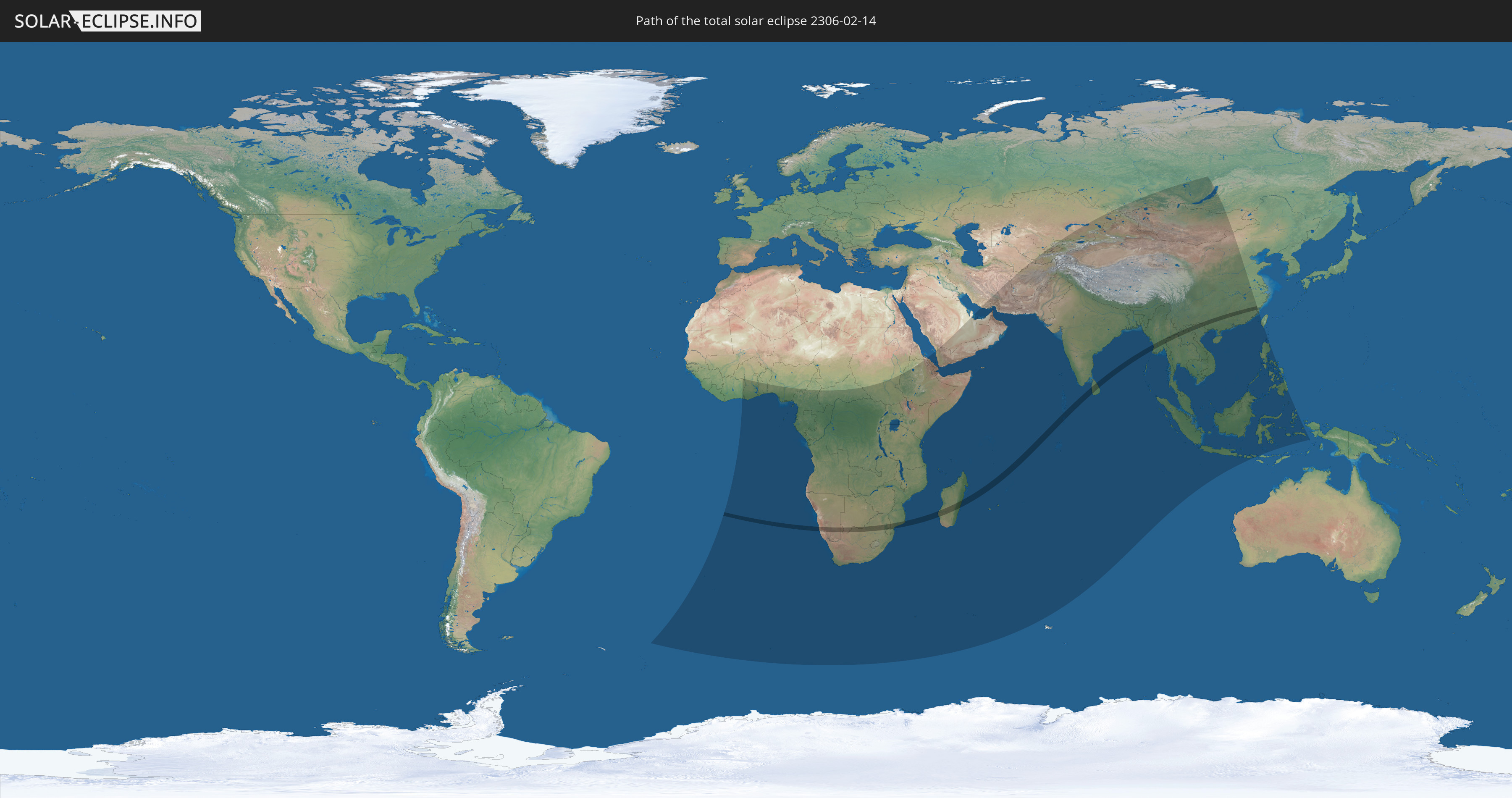
Die Sonnenfinsternis am 14.02.2306 kann man in 80 Ländern als partielle Sonnenfinsternis beobachten.
Der Finsternispfad verläuft durch 14 Länder. Nur in diesen Ländern ist sie als totale Sonnenfinsternis zu sehen.
In den folgenden Ländern ist die Sonnenfinsternis total zu sehen
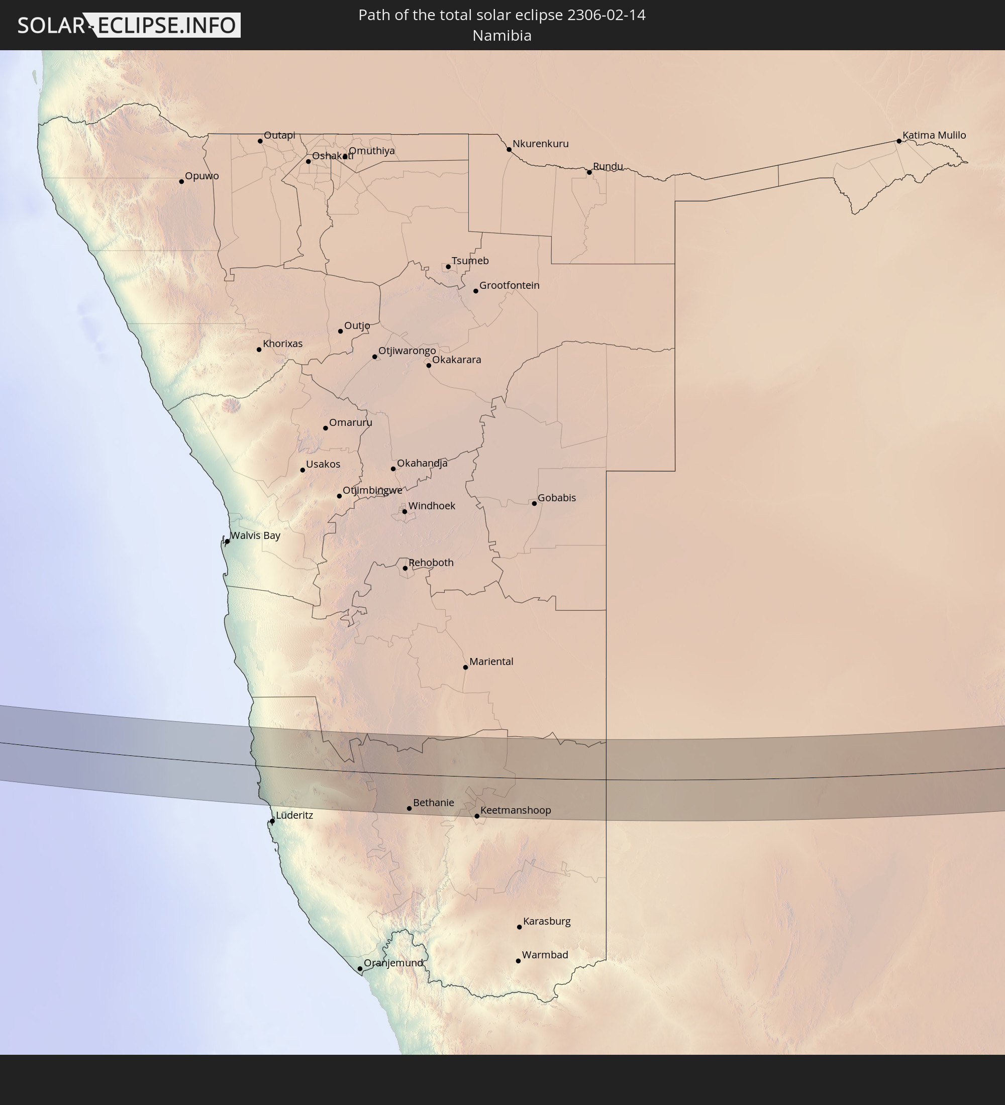 Namibia
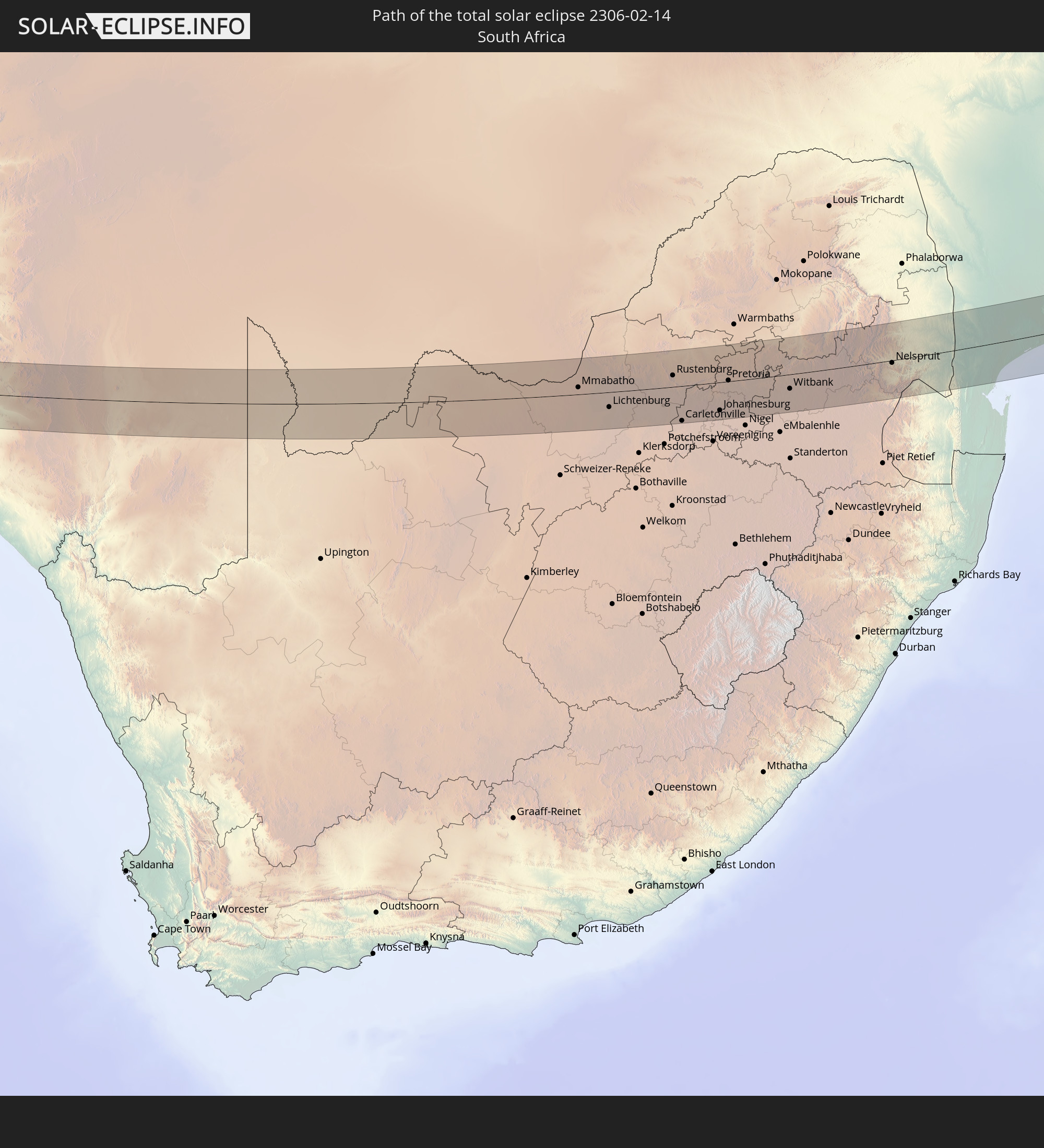 Südafrika
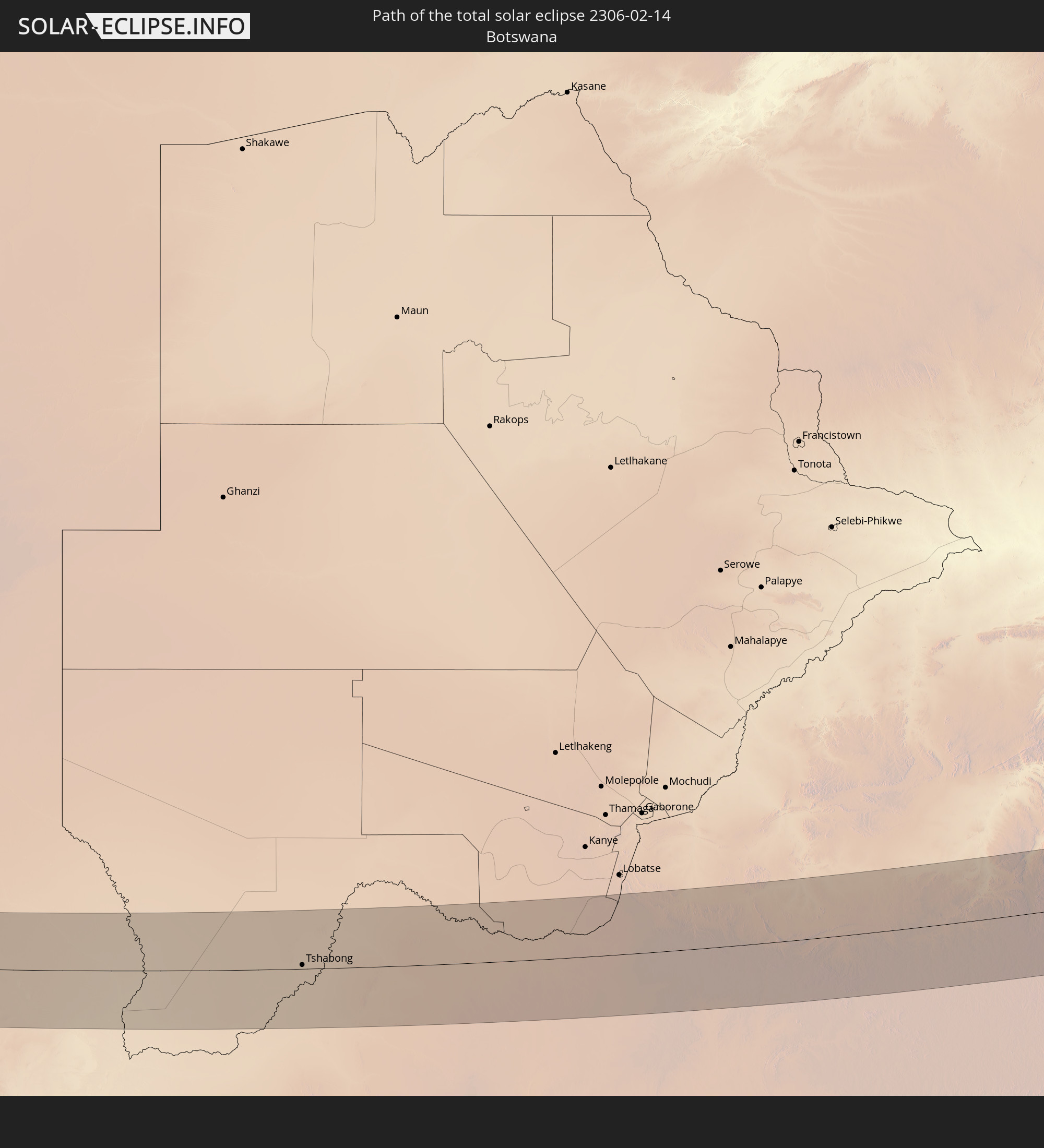 Botswana
 Mosambik
 Swasiland
 Französische Süd- und Antarktisgebiete
 Madagaskar
 Malediven
 Volksrepublik China
 Sri Lanka
 Myanmar
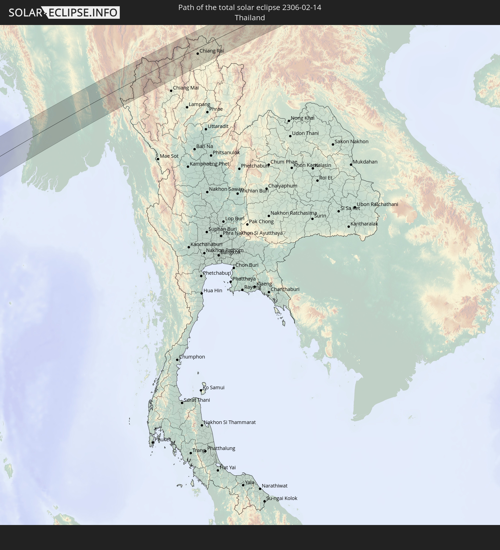 Thailand
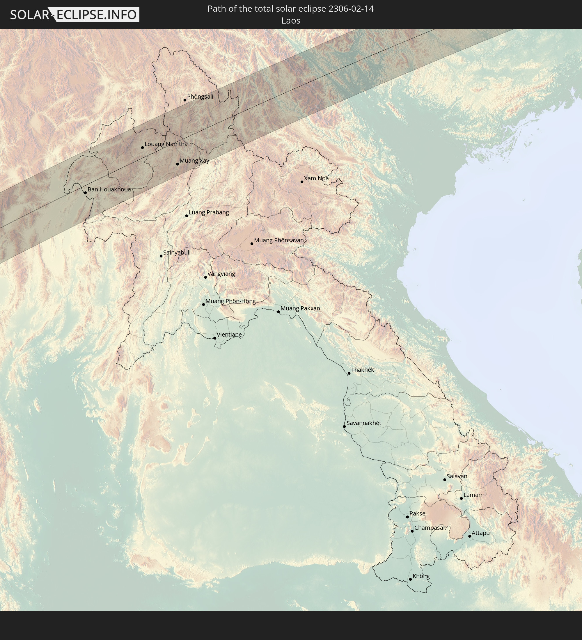 Laos
Laos
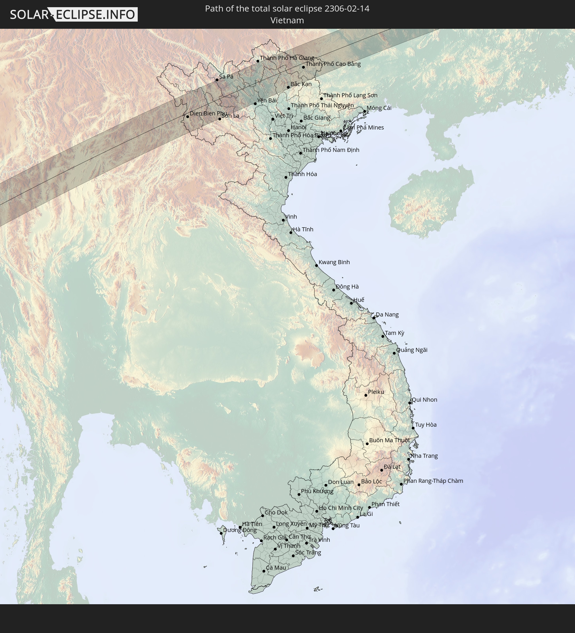 Vietnam
In den folgenden Ländern ist die Sonnenfinsternis partiell zu sehen
 Russland
 St. Helena
 Elfenbeinküste
 Burkina Faso
 Ghana
Ghana
 Togo
Togo
 Benin
Benin
 Nigeria
 Bouvetinsel
 Äquatorialguinea
 São Tomé und Príncipe
 Kamerun
 Gabun
Gabun
 Republik Kongo
 Angola
 Namibia
 Demokratische Republik Kongo
 Zentralafrikanische Republik
 Südafrika
 Botswana
 Sudan
Sudan
 Sambia
 Simbabwe
 Lesotho
 Ruanda
 Burundi
 Tansania
 Uganda
 Mosambik
 Swasiland
 Malawi
 Äthiopien
 Kenia
Kenia
 Saudi-Arabien
 Eritrea
 Französische Süd- und Antarktisgebiete
 Somalia
 Dschibuti
 Jemen
Jemen
 Madagaskar
 Komoren
 Iran
Iran
 Mayotte
 Seychellen
 Kasachstan
 Katar
Katar
 Vereinigte Arabische Emirate
 Oman
Oman
 Turkmenistan
 Réunion
 Usbekistan
 Mauritius
 Afghanistan
 Pakistan
 Tadschikistan
 Indien
 Kirgisistan
 Britisches Territorium im Indischen Ozean
 Malediven
 Volksrepublik China
 Sri Lanka
 Nepal
Nepal
 Mongolei
 Bangladesch
 Bhutan
 Myanmar
 Indonesien
 Kokosinseln
 Thailand
 Malaysia
 Laos
Laos
 Vietnam
 Kambodscha
 Singapur
 Weihnachtsinsel
 Macau
Macau
 Hongkong
 Brunei
 Taiwan
 Philippinen
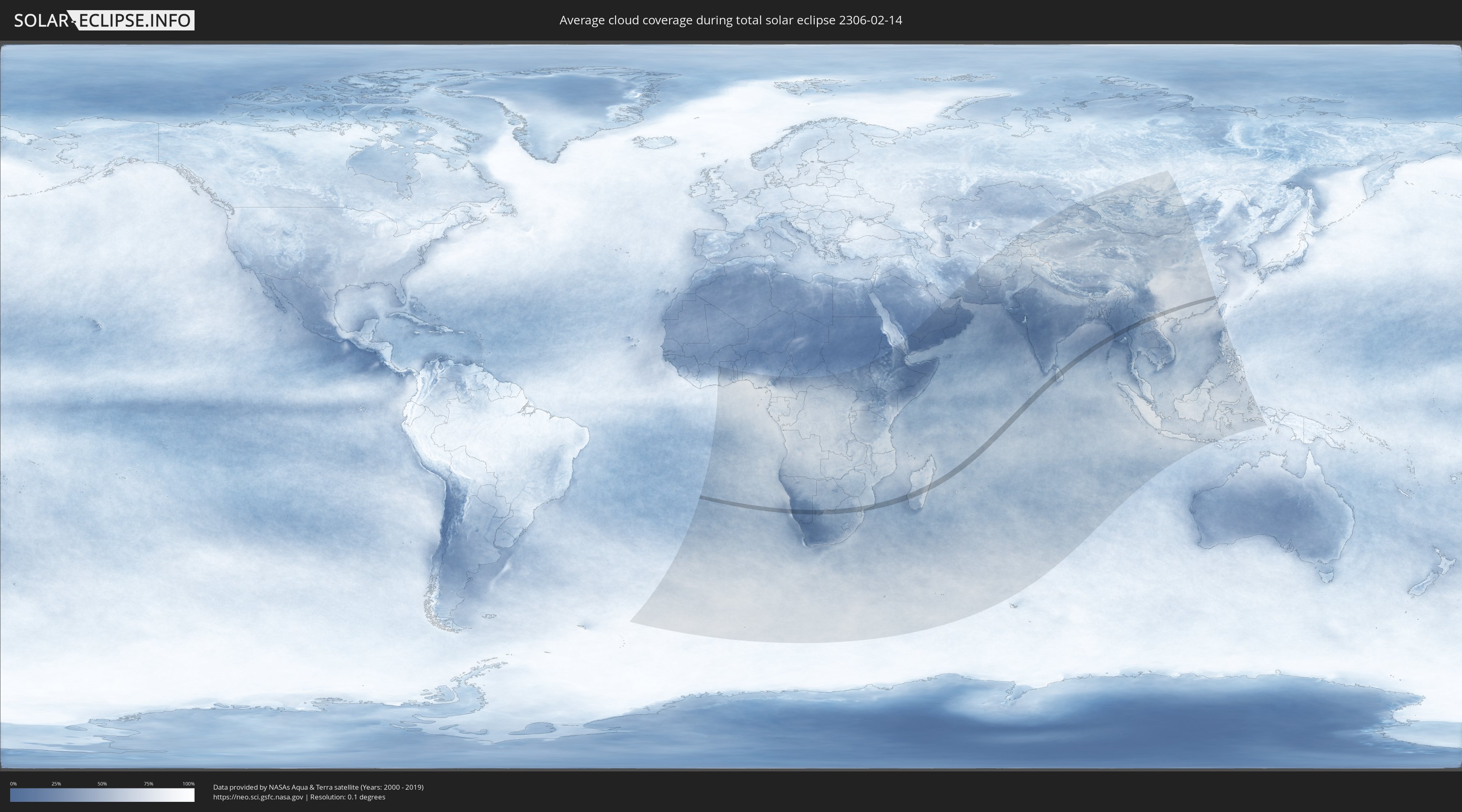
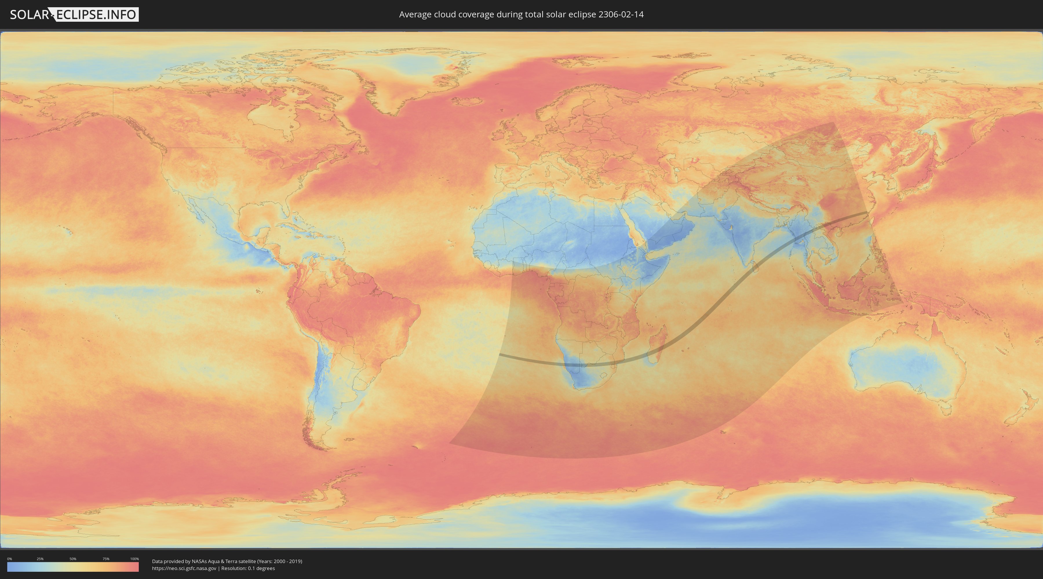
Wie wird das Wetter während der totalen Sonnenfinsternis am 14.02.2306?
Wo ist der beste Ort, um die totale Sonnenfinsternis vom 14.02.2306 zu beobachten?
Die folgenden Karten zeigen die durchschnittliche Bewölkung für den Tag, an dem die totale Sonnenfinsternis
stattfindet. Mit Hilfe der Karten lässt sich der Ort entlang des Finsternispfades eingrenzen,
der die besten Aussichen auf einen klaren wolkenfreien Himmel bietet.
Trotzdem muss man immer lokale Gegenenheiten beachten und sollte sich genau über das Wetter an seinem
gewählten Beobachtungsort informieren.
Die Daten stammen von den beiden NASA-Satelliten
AQUA und TERRA
und wurden über einen Zeitraum von 19 Jahren (2000 - 2019) gemittelt.
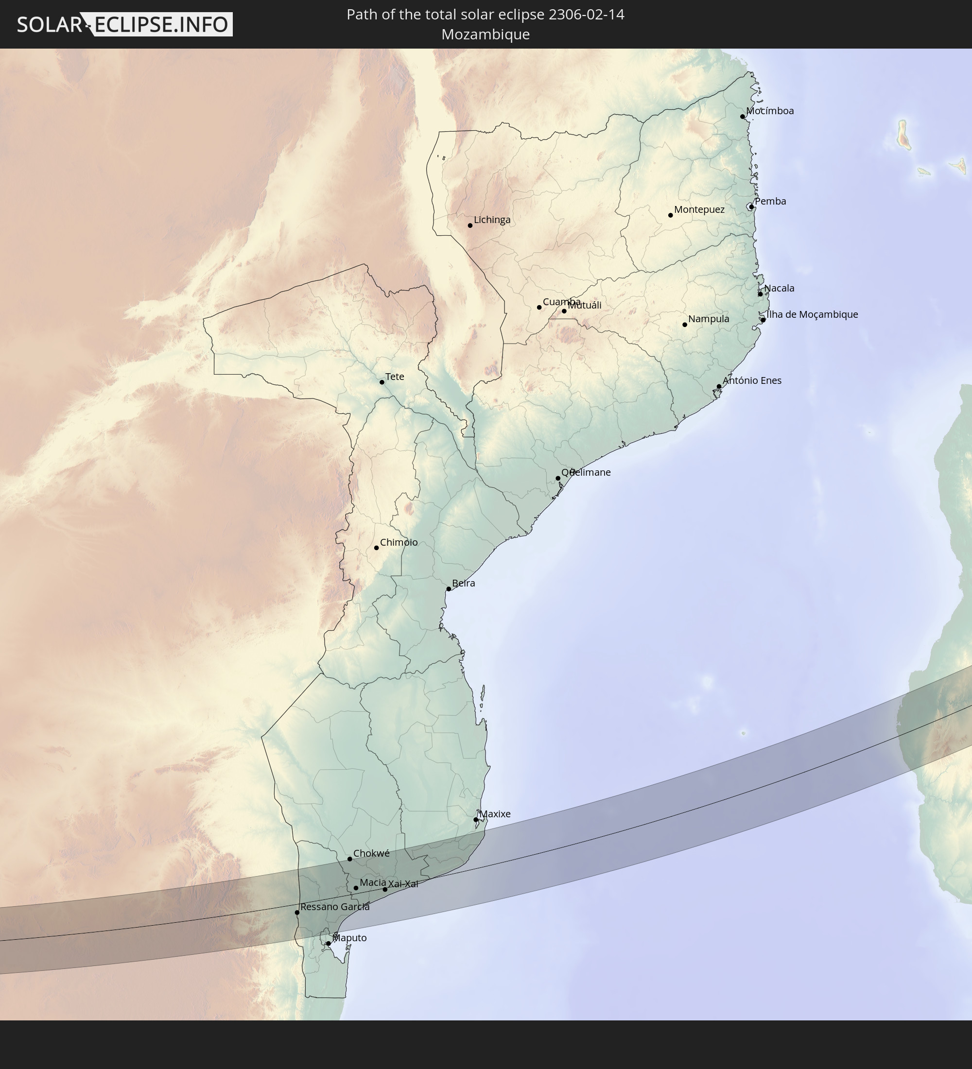
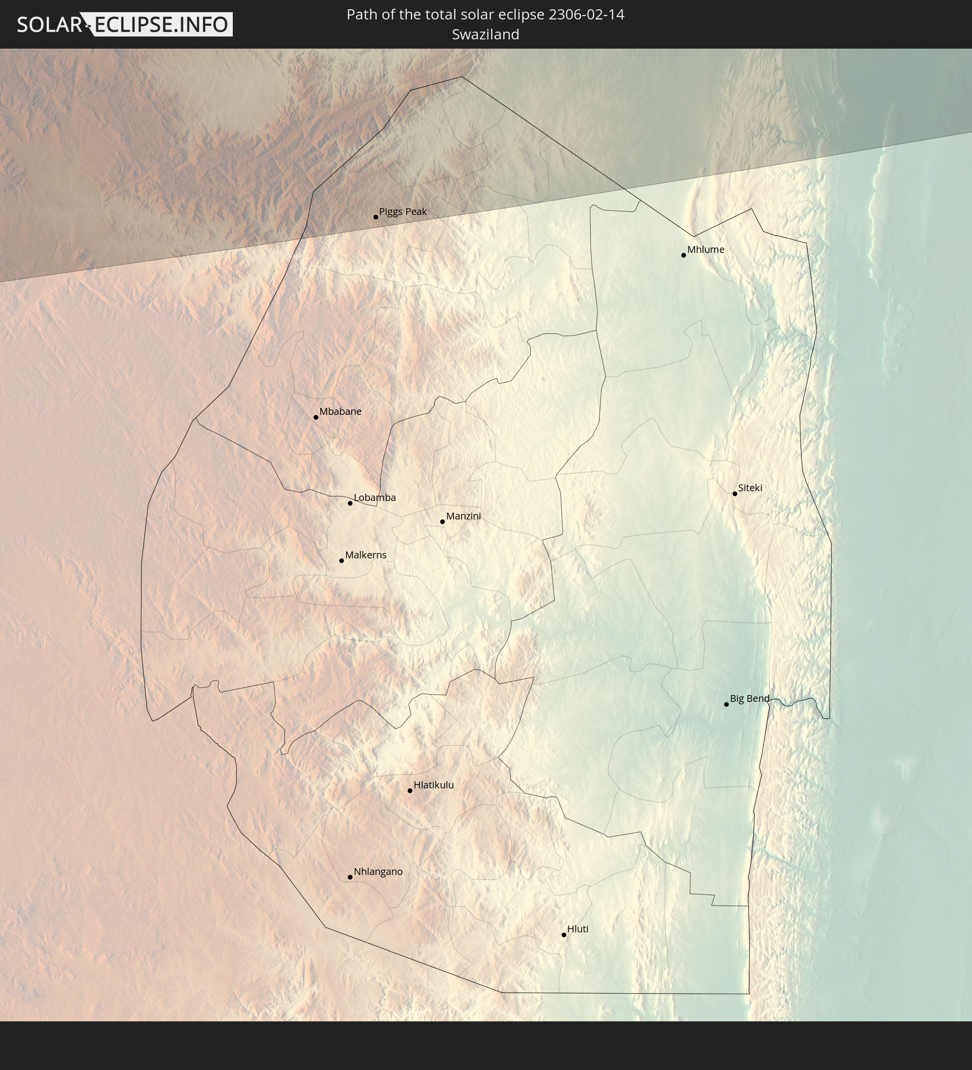
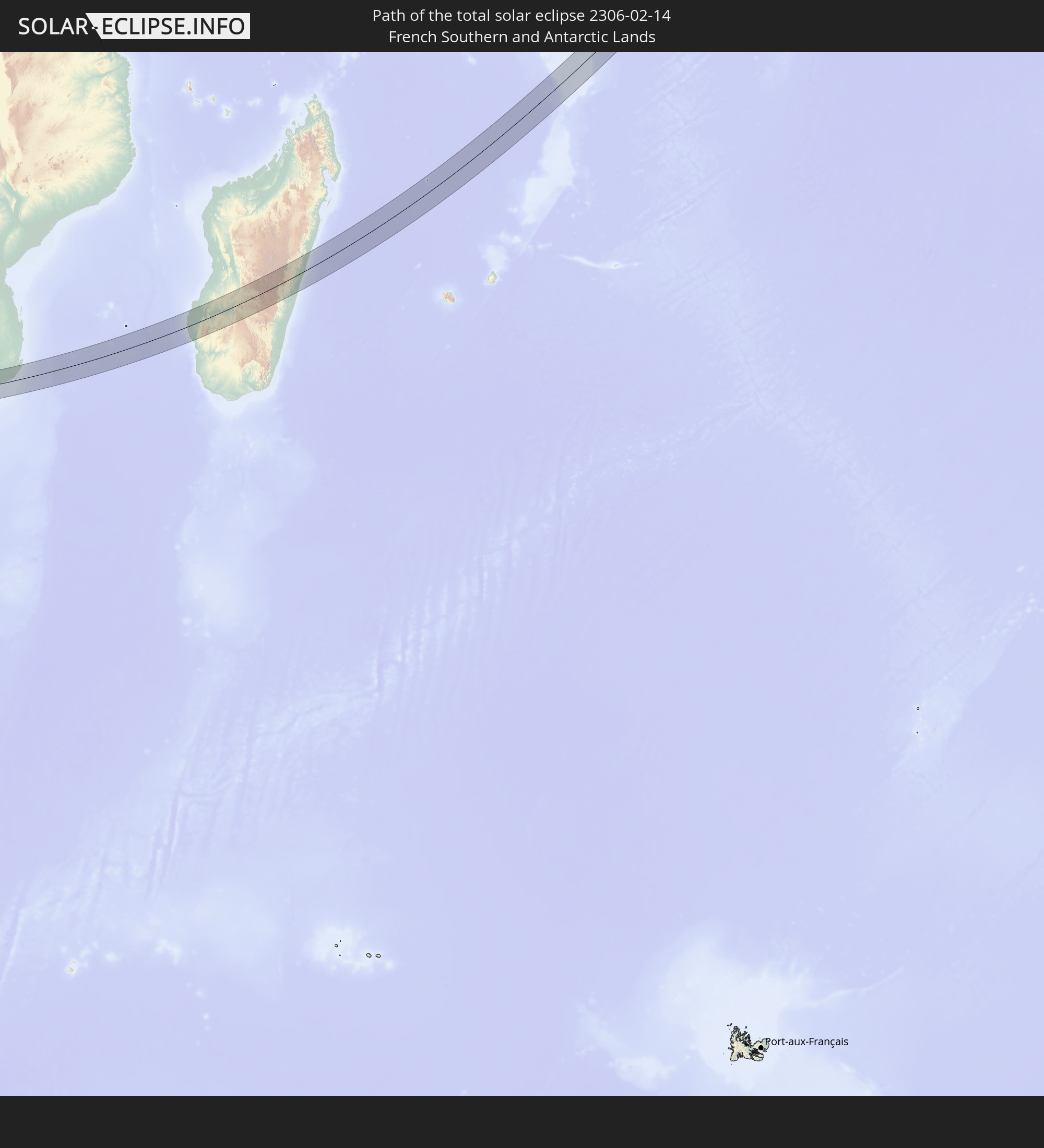
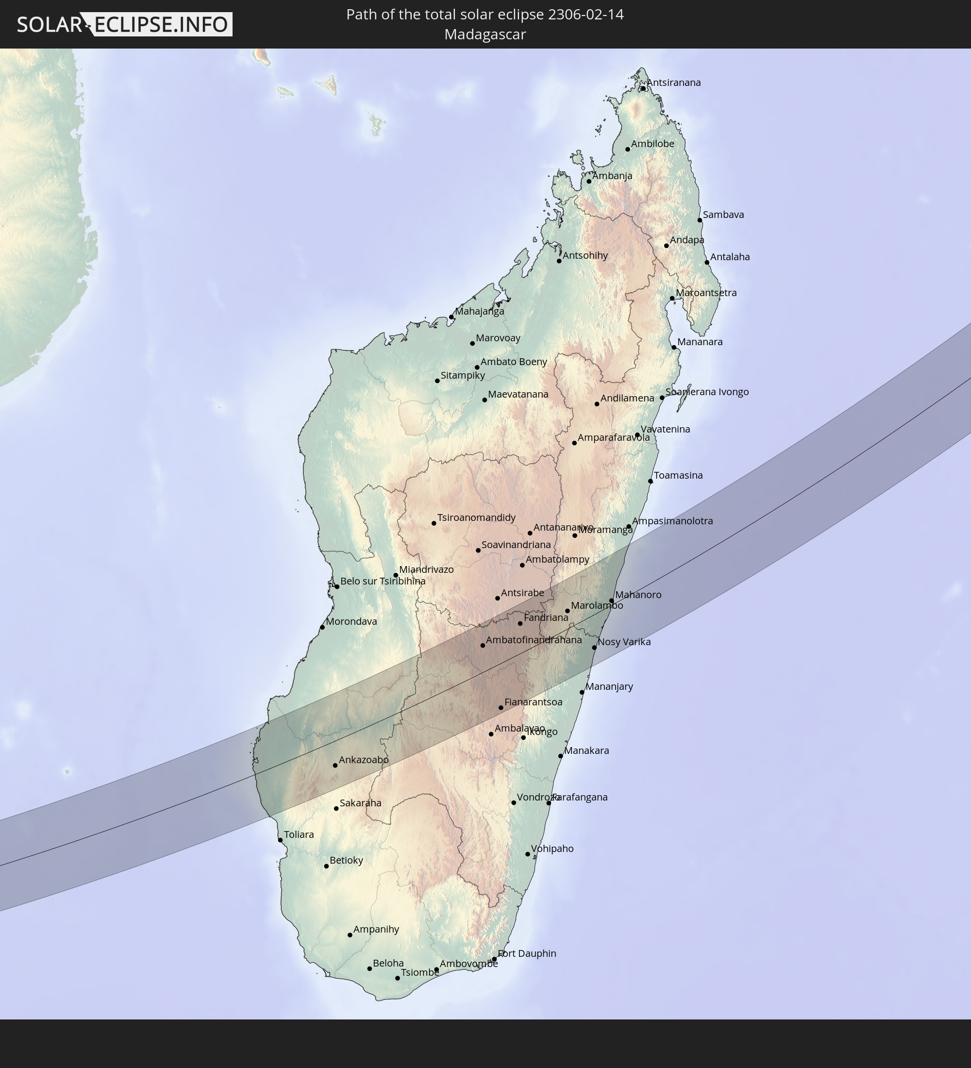
Detaillierte Länderkarten
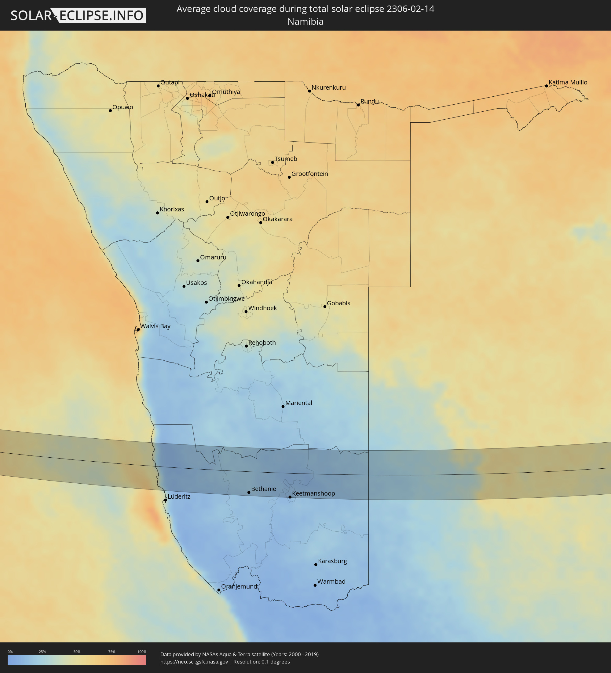 Namibia
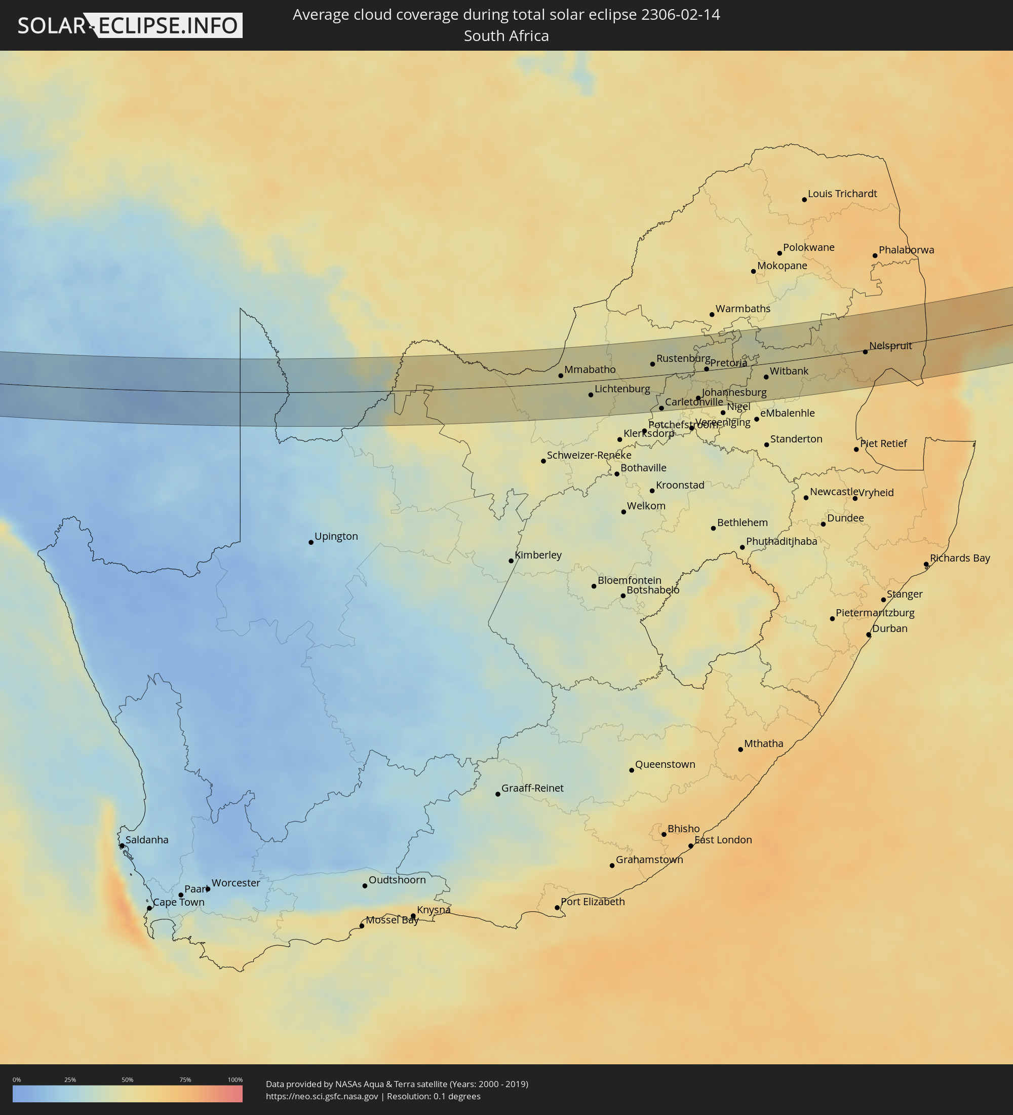 Südafrika
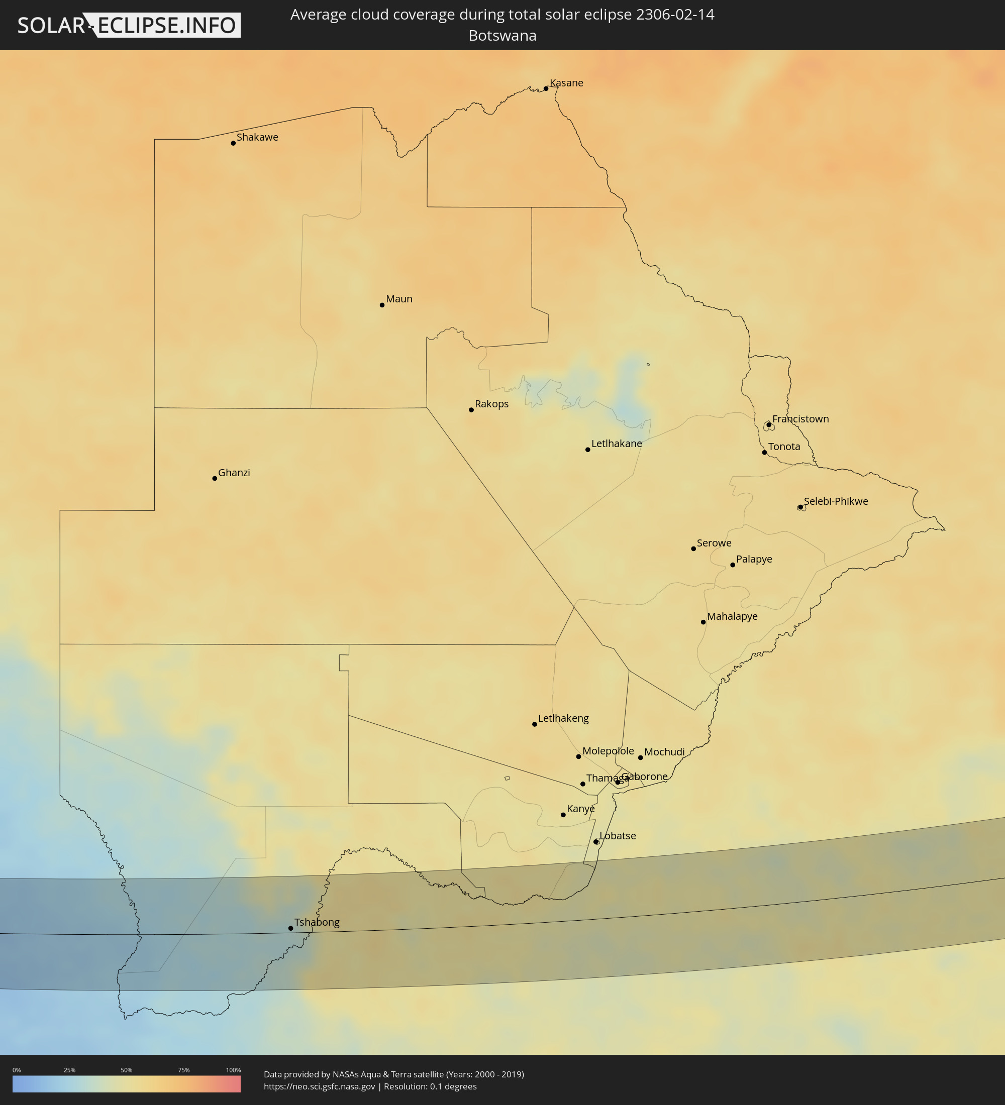 Botswana
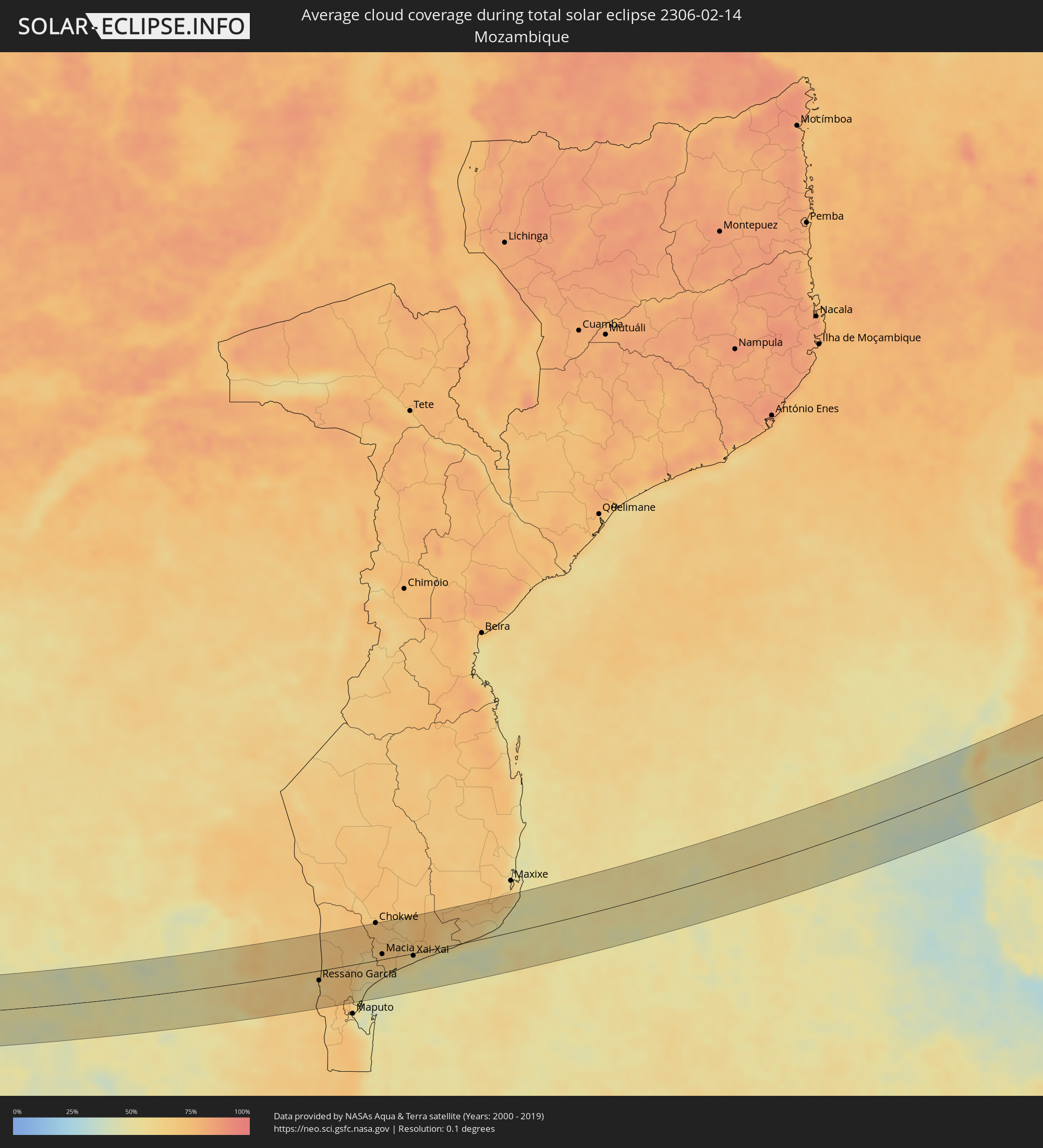 Mosambik
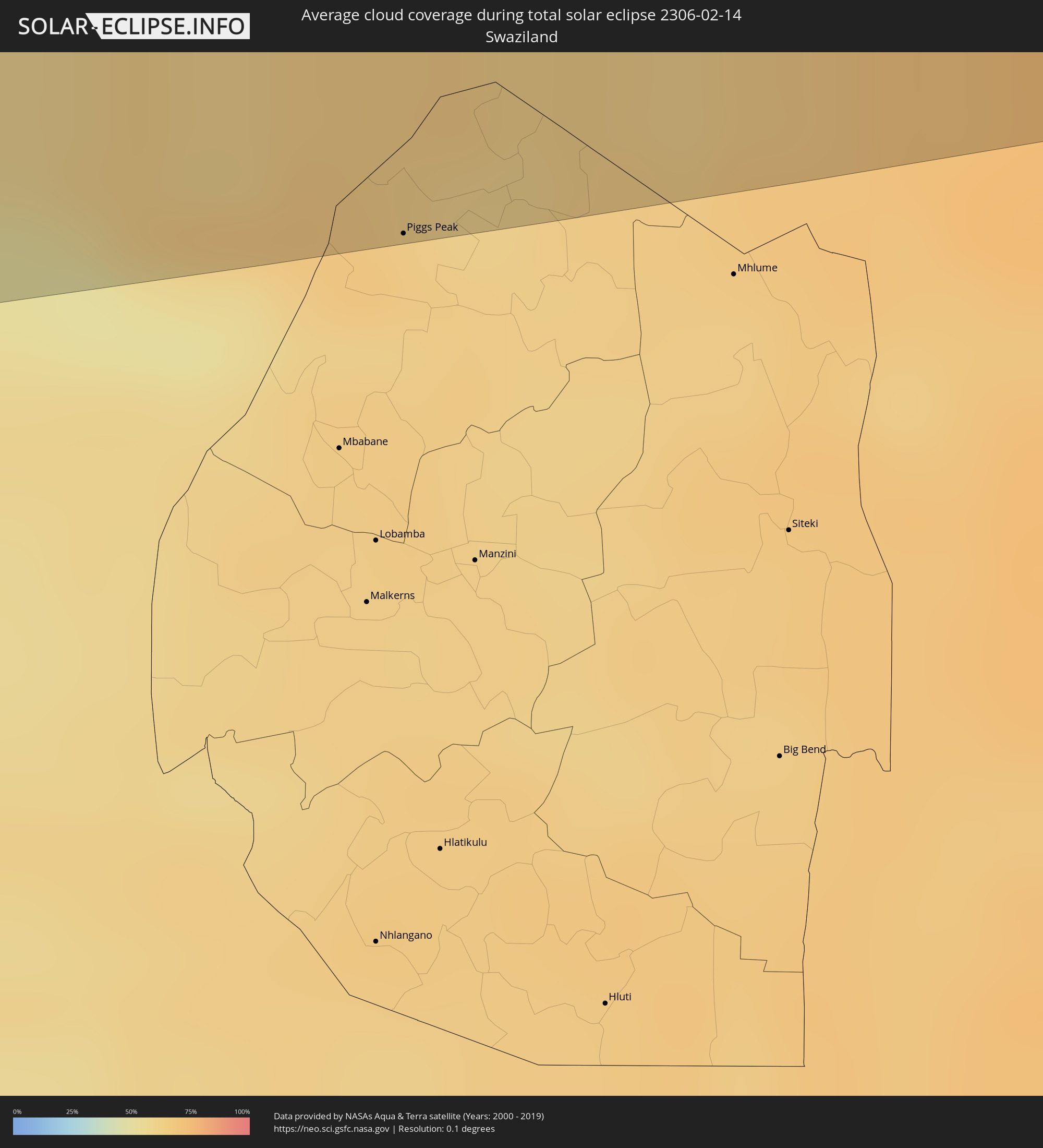 Swasiland
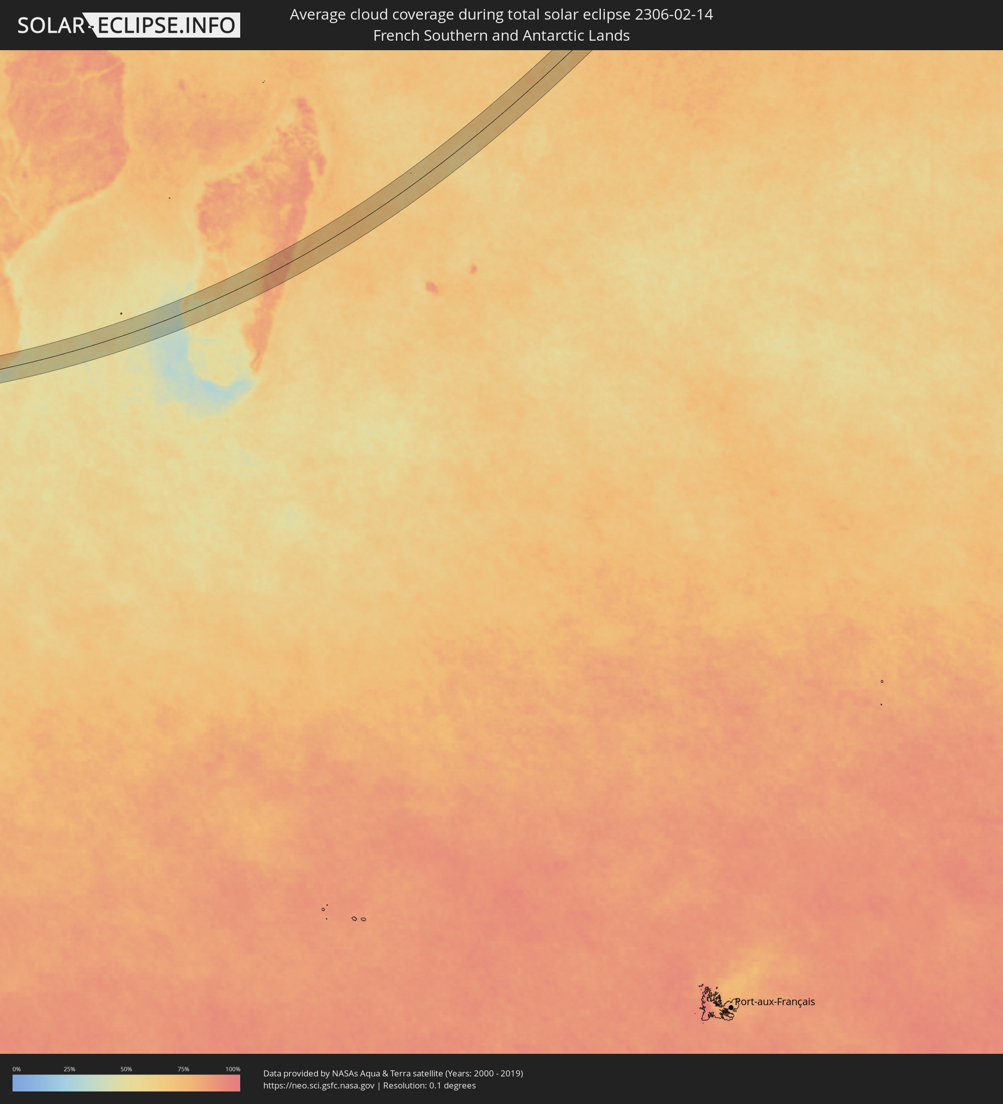 Französische Süd- und Antarktisgebiete
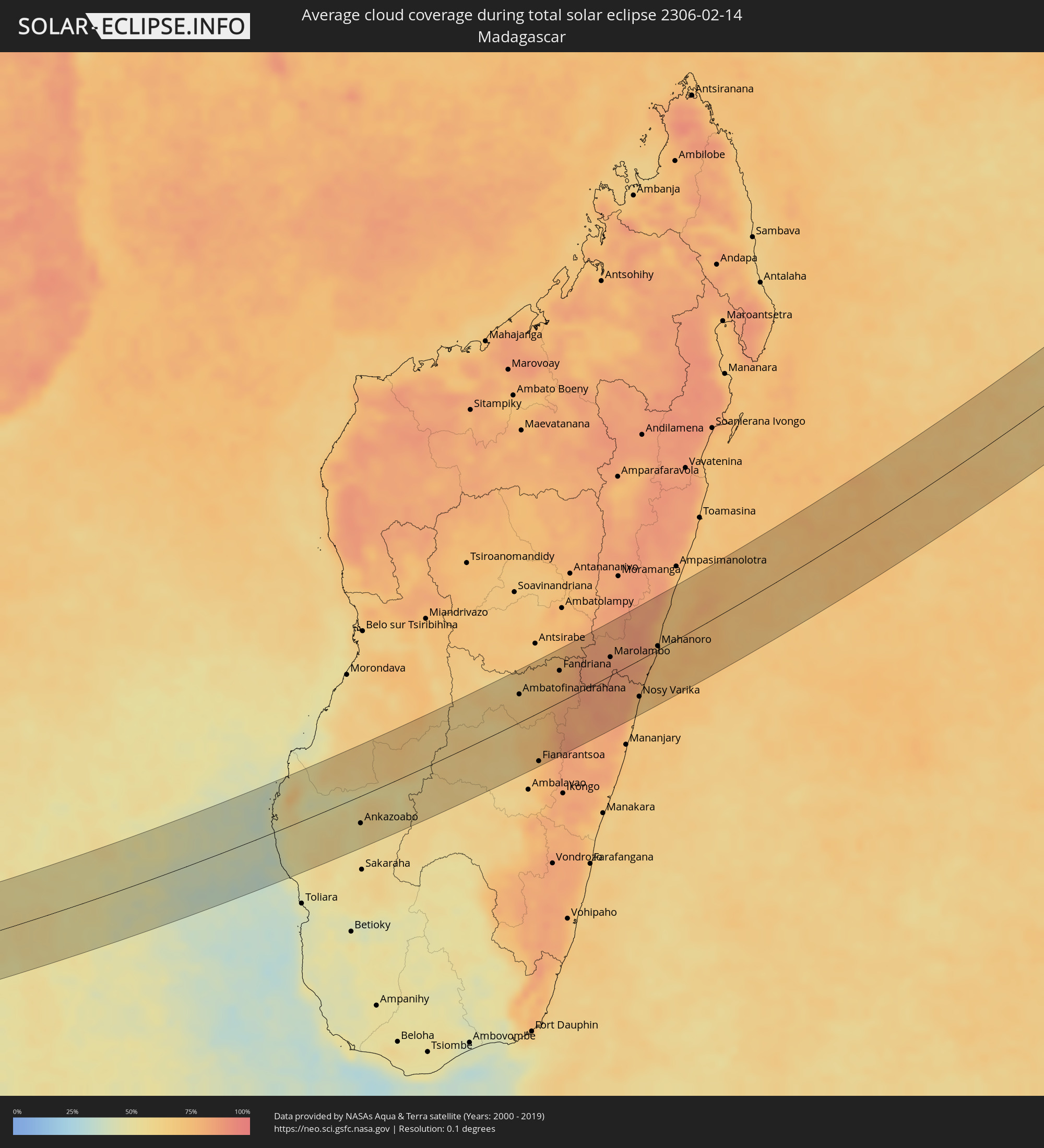 Madagaskar
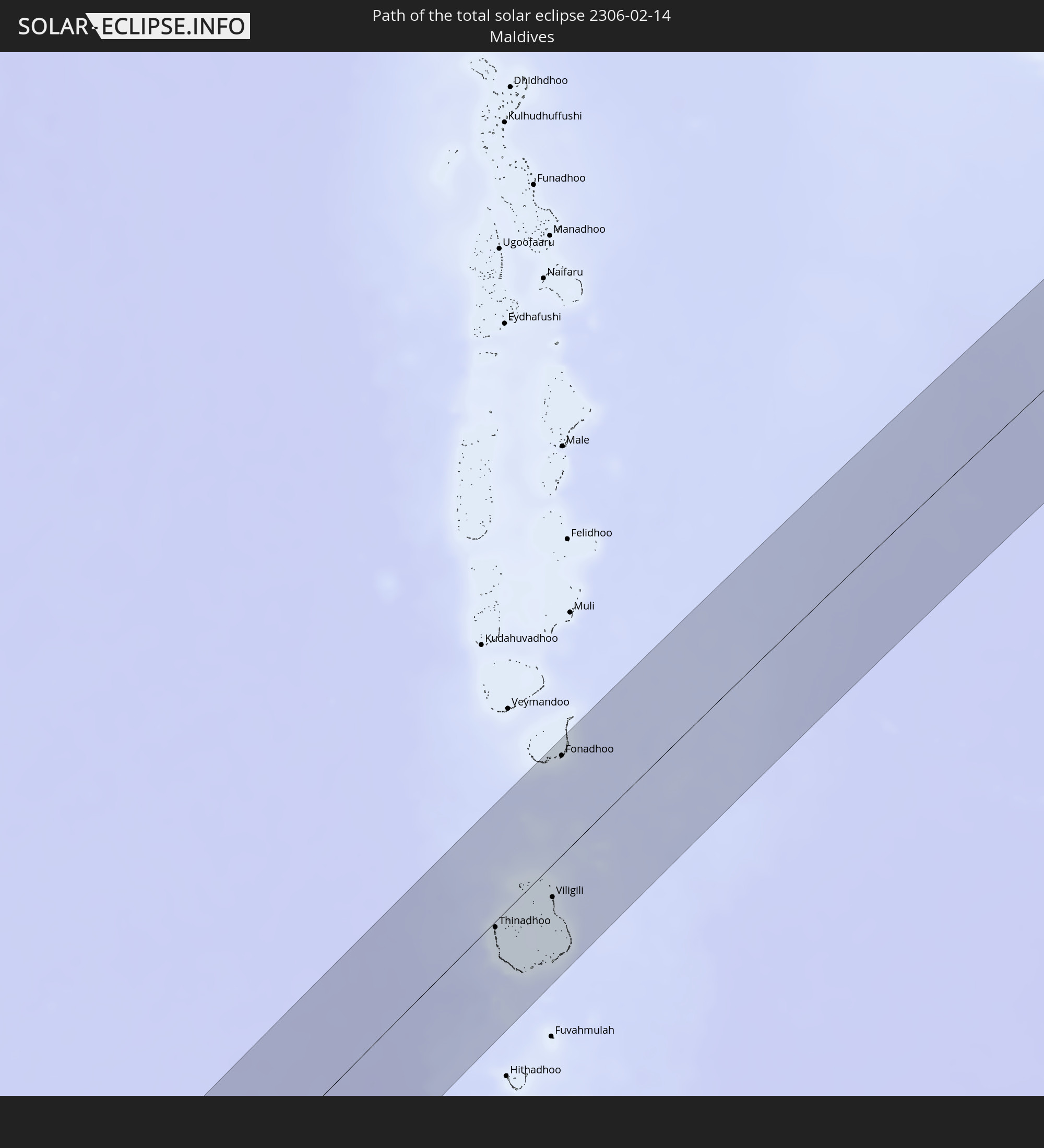
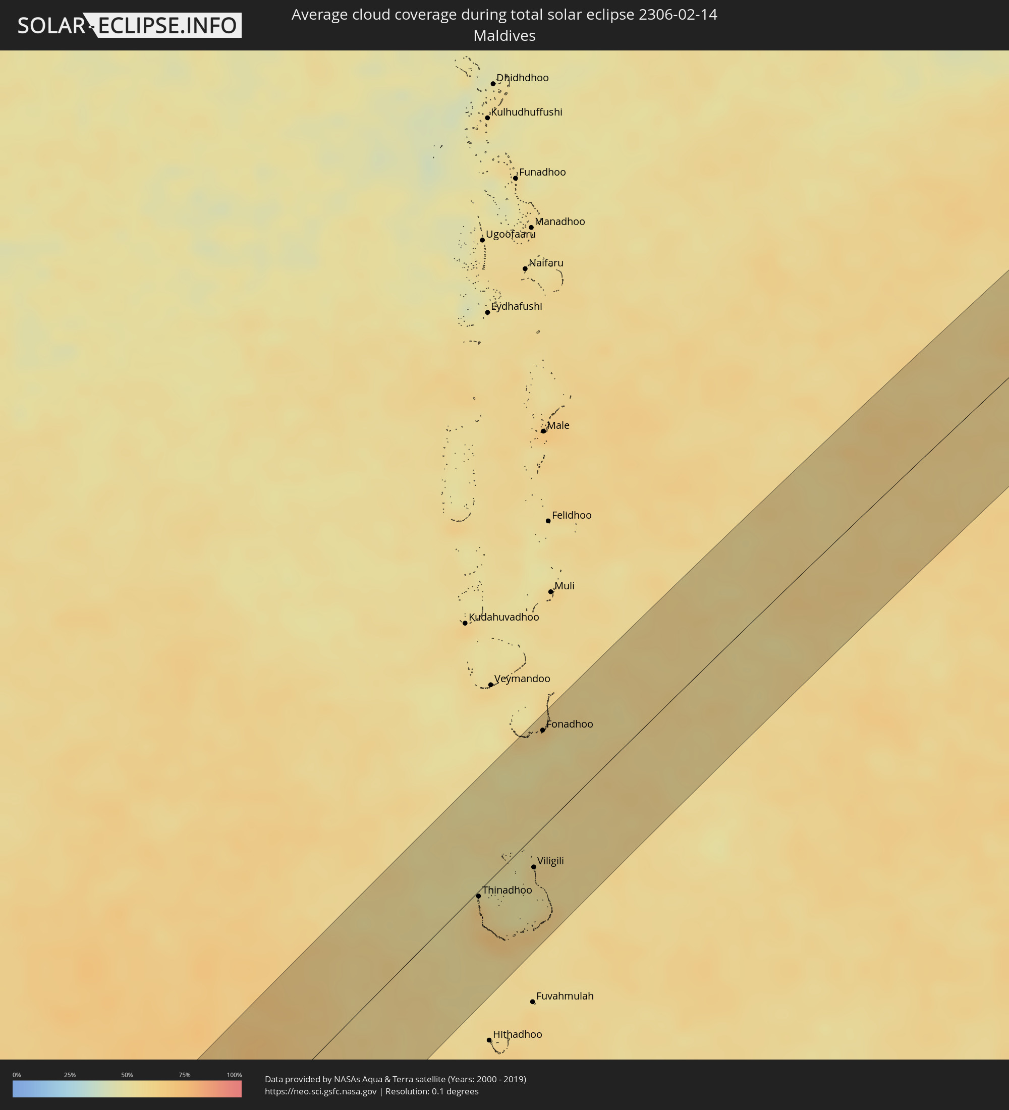 Malediven
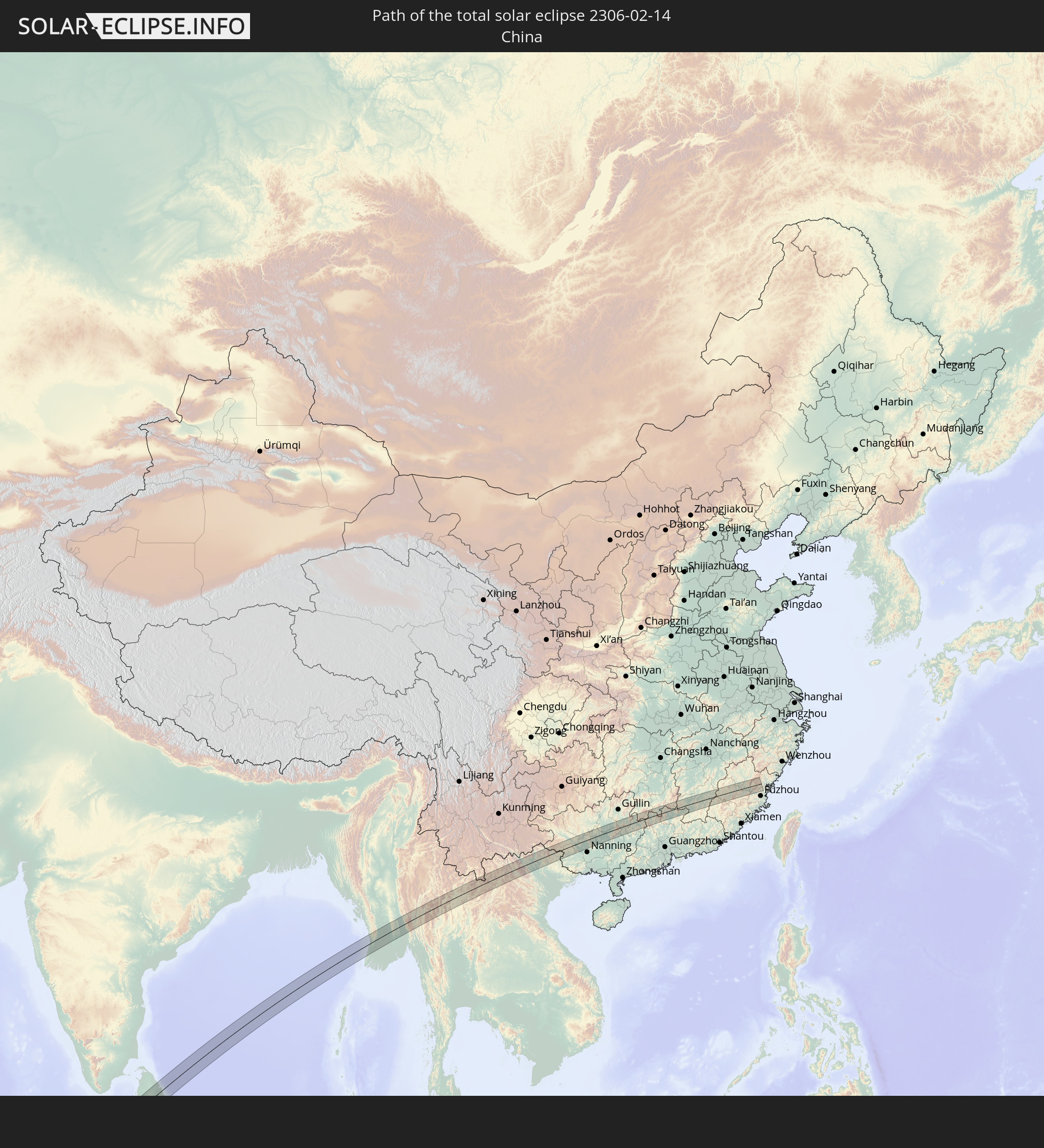
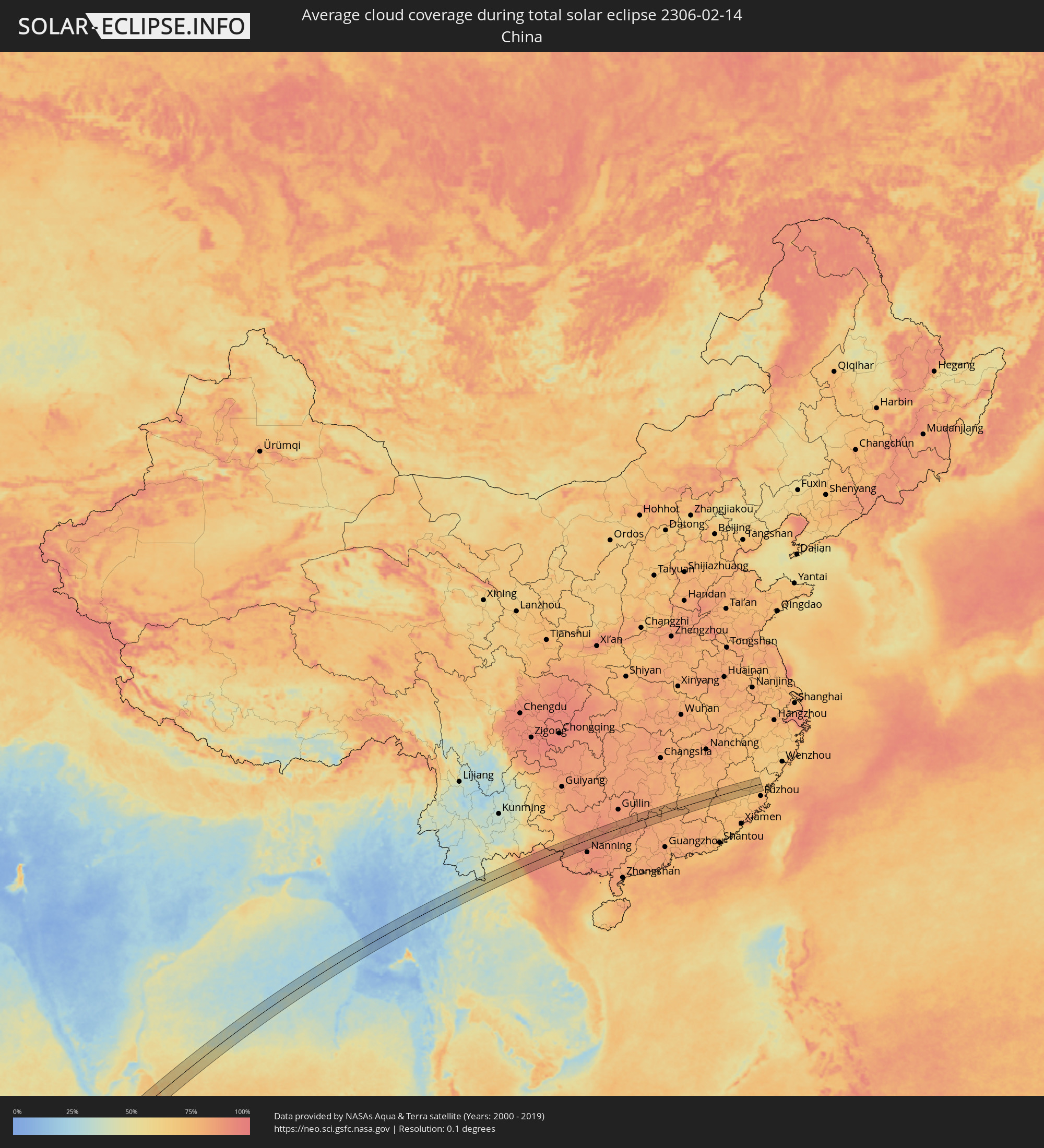 Volksrepublik China
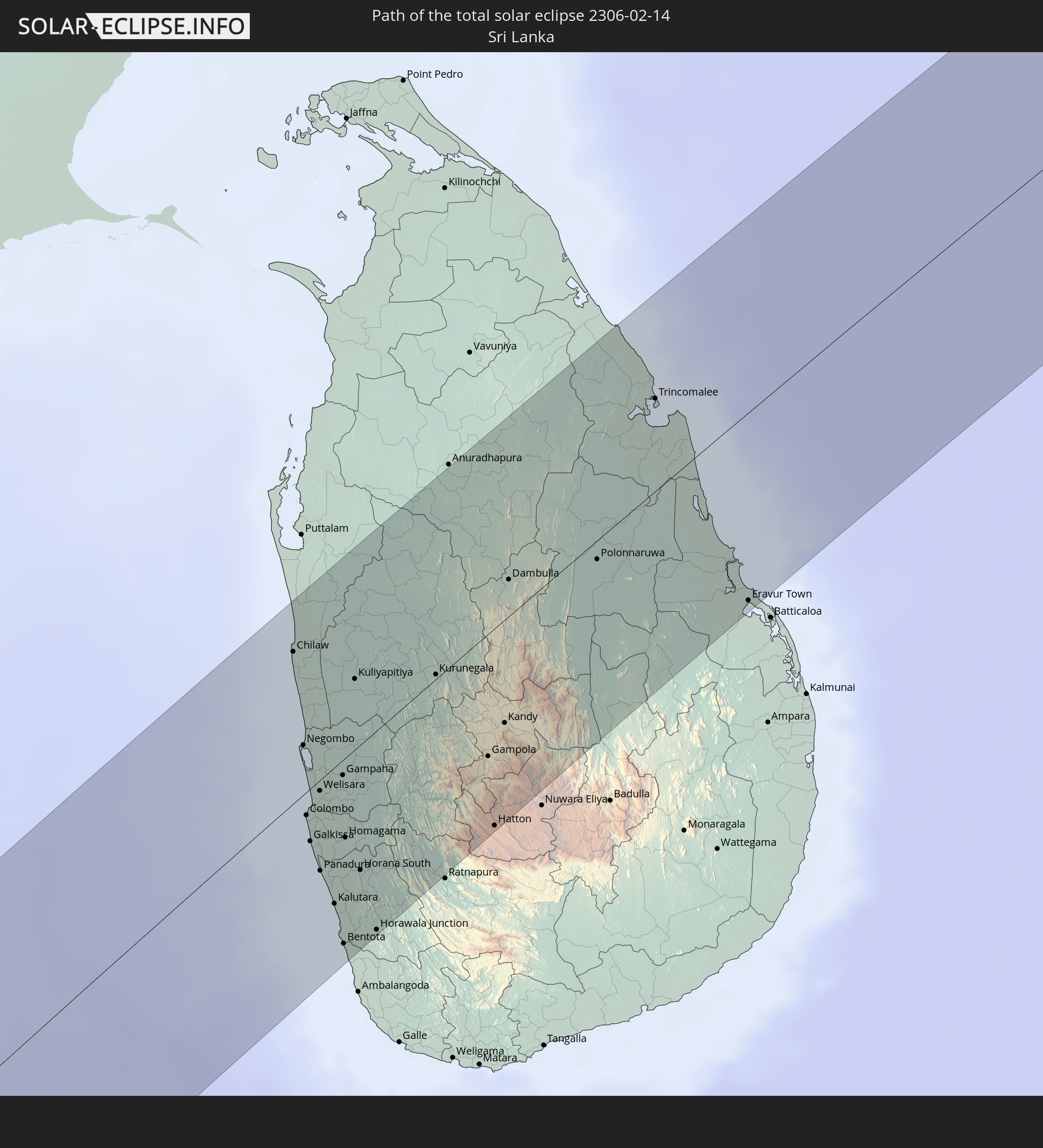
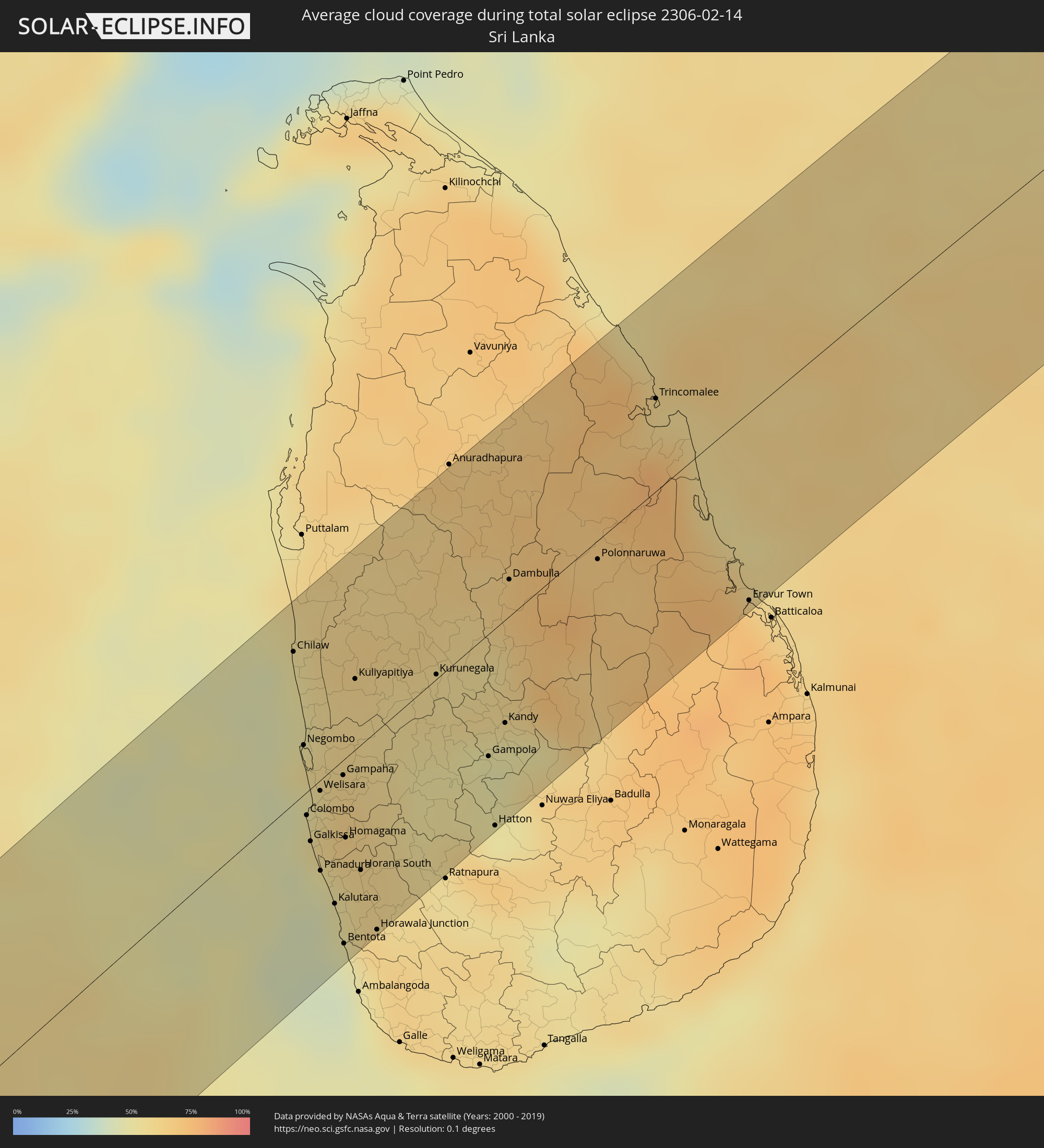 Sri Lanka
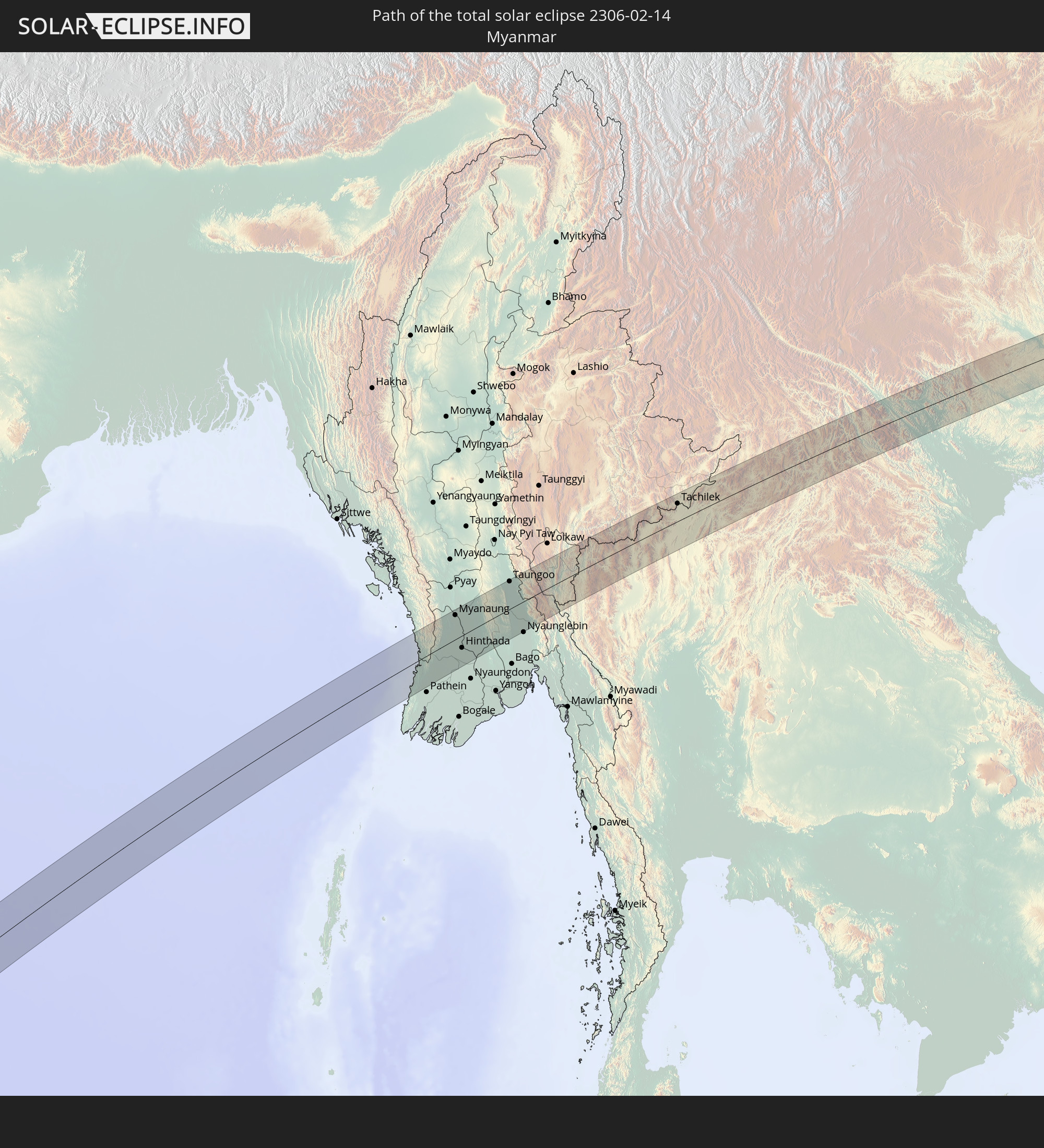
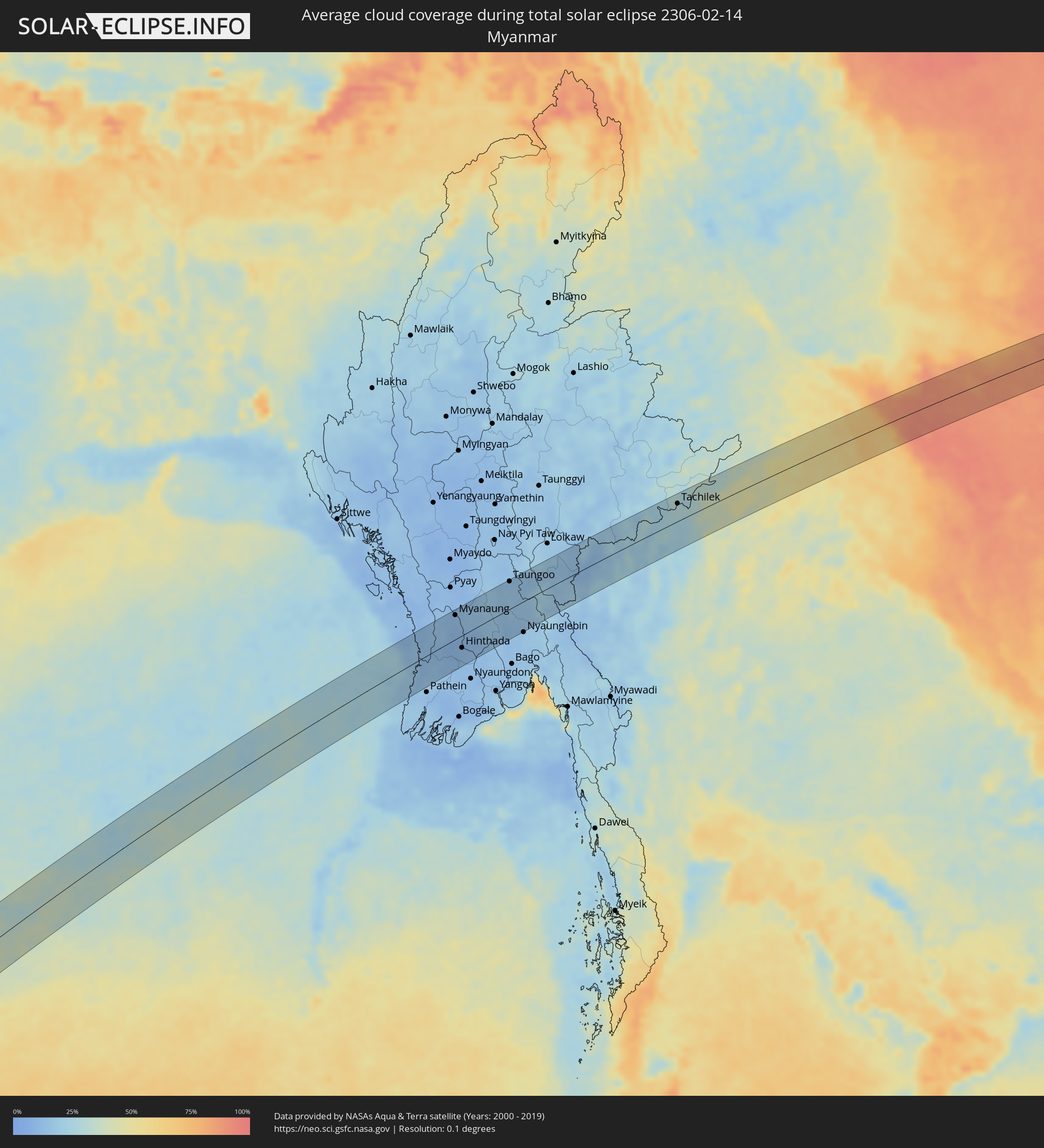 Myanmar
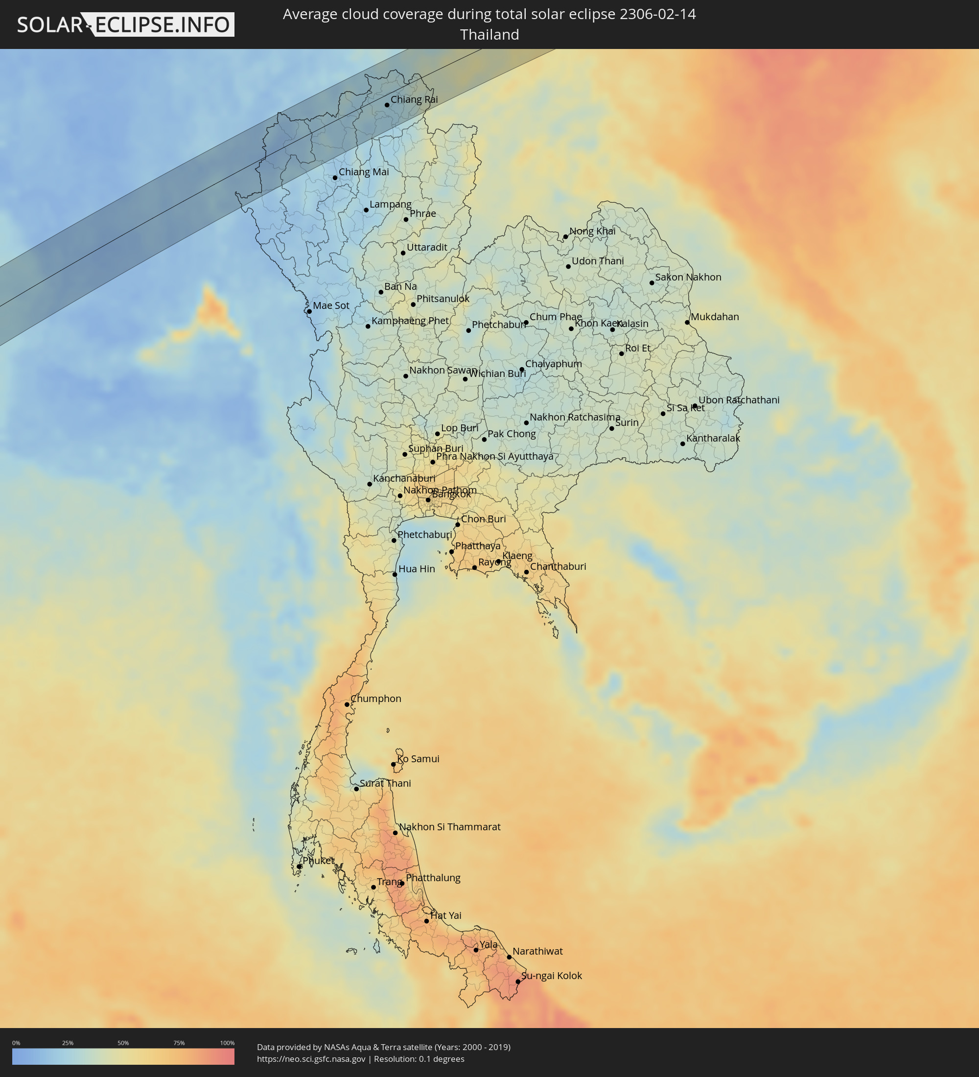 Thailand
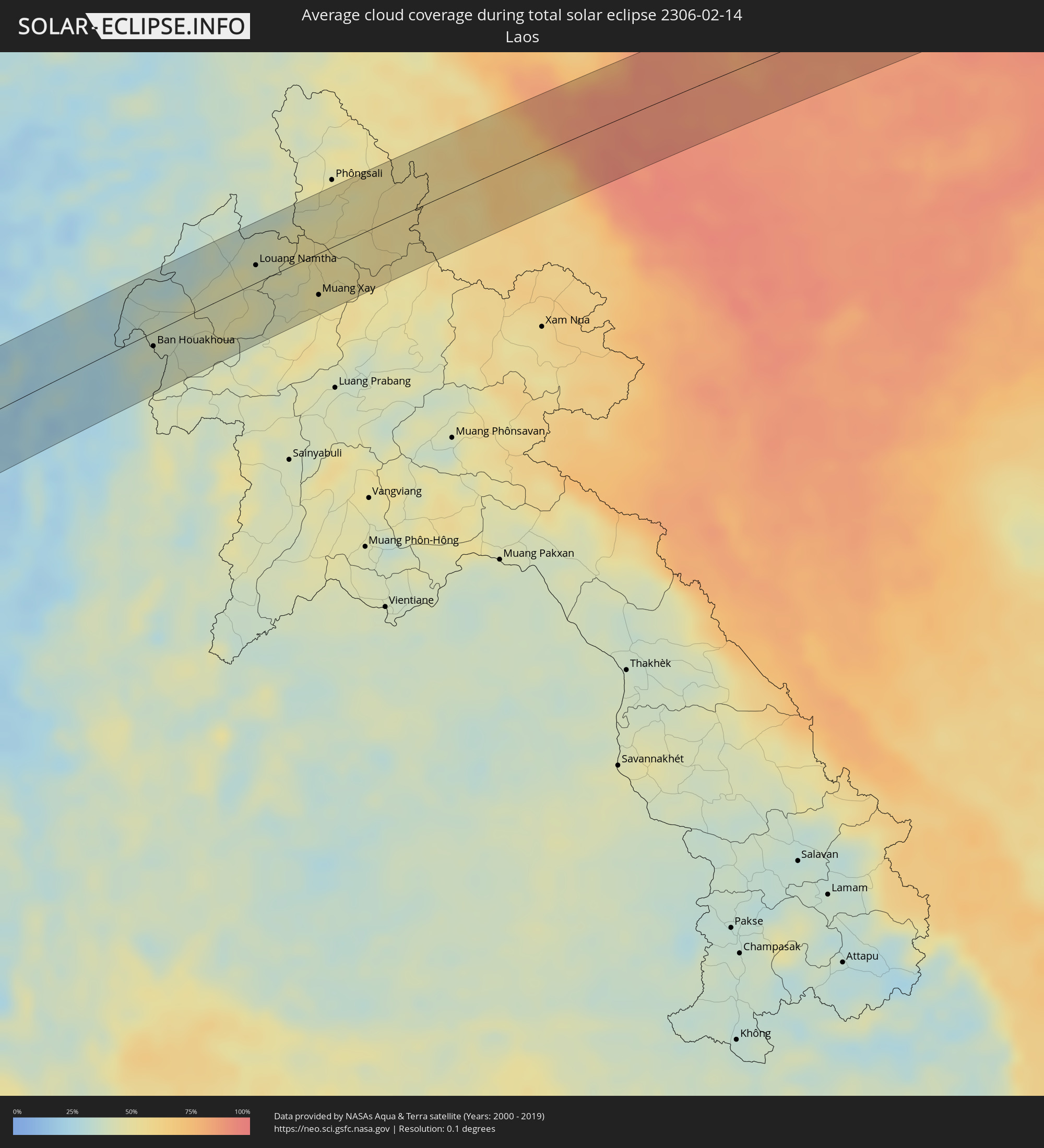 Laos
Laos
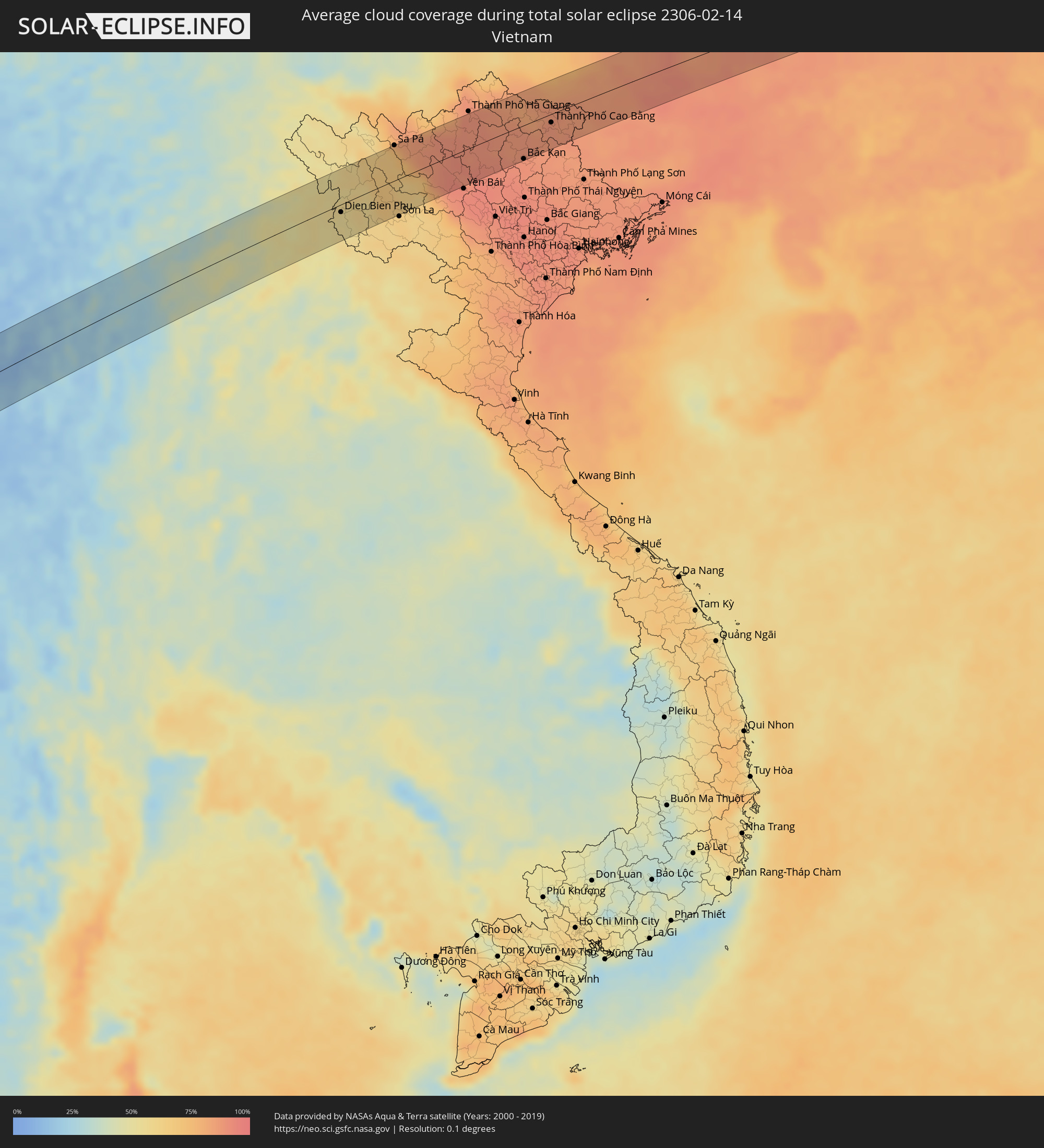 Vietnam
Orte im Finsternispfad
Die nachfolgene Tabelle zeigt Städte und Orte mit mehr als 5.000 Einwohnern, die sich im Finsternispfad befinden. Städte mit mehr als 100.000 Einwohnern sind dick gekennzeichnet. Mit einem Klick auf den Ort öffnet sich eine Detailkarte die die Lage des jeweiligen Ortes zusammen mit dem Verlauf der zentralen Finsternis präsentiert.
| Ort | Typ | Dauer der Verfinsterung | Ortszeit bei maximaler Verfinsterung | Entfernung zur Zentrallinie | Ø Bewölkung |
|
Bethanie, Karas
|
total | - | 08:31:55 UTC+02:00 | 50 km | 14% |
|
Tshabong, Kgalagadi
|
total | - | 08:36:55 UTC+02:00 | 4 km | 32% |
|
Janeng, South-East
|
total | - | 08:40:32 UTC+02:00 | 61 km | 47% |
|
Rustenburg, North-West
|
total | - | 08:42:34 UTC+02:00 | 19 km | 47% |
|
Carletonville, Gauteng
|
total | - | 08:42:36 UTC+02:00 | 59 km | 46% |
|
Westonaria, Gauteng
|
total | - | 08:42:55 UTC+02:00 | 57 km | 44% |
|
Krugersdorp, Gauteng
|
total | - | 08:43:09 UTC+02:00 | 32 km | 53% |
|
Brits, North-West
|
total | - | 08:43:16 UTC+02:00 | 18 km | 43% |
|
Soweto, Gauteng
|
total | - | 08:43:12 UTC+02:00 | 53 km | 49% |
|
Diepsloot, Gauteng
|
total | - | 08:43:29 UTC+02:00 | 17 km | 46% |
|
Johannesburg, Gauteng
|
total | - | 08:43:28 UTC+02:00 | 48 km | 51% |
|
Mabopane, Gauteng
|
total | - | 08:43:44 UTC+02:00 | 30 km | 46% |
|
Pretoria, Gauteng
|
total | - | 08:43:46 UTC+02:00 | 2 km | 50% |
|
Tembisa, Gauteng
|
total | - | 08:43:45 UTC+02:00 | 27 km | 53% |
|
Benoni, Gauteng
|
total | - | 08:43:49 UTC+02:00 | 49 km | 53% |
|
Delmas, Mpumalanga
|
total | - | 08:44:18 UTC+02:00 | 48 km | 48% |
|
Witbank, Mpumalanga
|
total | - | 08:45:07 UTC+02:00 | 24 km | 49% |
|
Middelburg, Mpumalanga
|
total | - | 08:45:28 UTC+02:00 | 17 km | 49% |
|
Nelspruit, Mpumalanga
|
total | - | 08:47:40 UTC+02:00 | 4 km | 63% |
|
Piggs Peak, Hhohho
|
total | - | 08:47:53 UTC+02:00 | 63 km | 62% |
|
Ressano Garcia, Maputo
|
total | - | 08:49:10 UTC+02:00 | 17 km | 63% |
|
Chokwé, Gaza
|
total | - | 08:51:04 UTC+02:00 | 65 km | 69% |
|
Macia, Gaza
|
total | - | 08:51:00 UTC+02:00 | 9 km | 69% |
|
Chibuto, Gaza
|
total | - | 08:51:50 UTC+02:00 | 38 km | 64% |
|
Xai-Xai, Gaza
|
total | - | 08:51:50 UTC+02:00 | 4 km | 56% |
|
Manjacaze, Gaza
|
total | - | 08:52:23 UTC+02:00 | 28 km | 72% |
|
Ankazoabo, Atsimo-Andrefana
|
total | - | 10:13:12 UTC+03:00 | 37 km | 53% |
|
Beroroha, Atsimo-Andrefana
|
total | - | 10:15:09 UTC+03:00 | 2 km | 53% |
|
Ikalamavony, Upper Matsiatra
|
total | - | 10:18:36 UTC+03:00 | 12 km | 60% |
|
Ambatofinandrahana, Amoron'i Mania
|
total | - | 10:19:47 UTC+03:00 | 38 km | 66% |
|
Fianarantsoa, Upper Matsiatra
|
total | - | 10:19:15 UTC+03:00 | 65 km | 75% |
|
Ambositra, Amoron'i Mania
|
total | - | 10:20:43 UTC+03:00 | 19 km | 75% |
|
Fandriana, Amoron'i Mania
|
total | - | 10:21:23 UTC+03:00 | 42 km | 76% |
|
Marolambo, Atsinanana
|
total | - | 10:23:08 UTC+03:00 | 24 km | 84% |
|
Sahavato, Vatovavy Fitovinany
|
total | - | 10:22:52 UTC+03:00 | 40 km | 83% |
|
Nosy Varika, Vatovavy Fitovinany
|
total | - | 10:23:18 UTC+03:00 | 48 km | 71% |
|
Mahanoro, Atsinanana
|
total | - | 10:24:46 UTC+03:00 | 5 km | 73% |
|
Thinadhoo, Gaafu Dhaalu Atholhu
|
total | - | 13:50:54 UTC+05:00 | 3 km | 65% |
|
Viligili, Gaafu Alifu Atholhu
|
total | - | 13:52:00 UTC+05:00 | 20 km | 57% |
|
Fonadhoo, Laamu
|
total | - | 13:54:00 UTC+05:00 | 60 km | 56% |
|
Chilaw, North Western
|
total | - | 14:42:16 UTC+05:30 | 50 km | 51% |
|
Negombo, Western
|
total | - | 14:41:47 UTC+05:30 | 16 km | 52% |
|
Colombo, Western
|
total | - | 14:41:24 UTC+05:30 | 8 km | 47% |
|
Moratuwa, Western
|
total | - | 14:41:13 UTC+05:30 | 23 km | 50% |
|
Peliyagoda, Western
|
total | - | 14:41:30 UTC+05:30 | 7 km | 55% |
|
Wattala, Western
|
total | - | 14:41:31 UTC+05:30 | 7 km | 55% |
|
Ja Ela, Western
|
total | - | 14:41:40 UTC+05:30 | 1 km | 54% |
|
Kelaniya, Western
|
total | - | 14:41:32 UTC+05:30 | 11 km | 55% |
|
Kalutara, Western
|
total | - | 14:41:02 UTC+05:30 | 45 km | 51% |
|
Bentota, Southern
|
total | - | 14:40:51 UTC+05:30 | 61 km | 43% |
|
Homagama, Western
|
total | - | 14:41:29 UTC+05:30 | 26 km | 58% |
|
Kurunegala, North Western
|
total | - | 14:42:52 UTC+05:30 | 2 km | 55% |
|
Gampola, Central
|
total | - | 14:42:40 UTC+05:30 | 41 km | 47% |
|
Kandy, Central
|
total | - | 14:42:57 UTC+05:30 | 34 km | 49% |
|
Dambulla, Central
|
total | - | 14:43:46 UTC+05:30 | 12 km | 69% |
|
Trincomalee, Eastern Province
|
total | - | 14:45:28 UTC+05:30 | 31 km | 61% |
|
Myanaung, Ayeyarwady
|
total | - | 16:08:43 UTC+06:30 | 46 km | 13% |
|
Hinthada, Ayeyarwady
|
total | - | 16:08:21 UTC+06:30 | 23 km | 12% |
|
Paungde, Bago
|
total | - | 16:08:59 UTC+06:30 | 56 km | 13% |
|
Letpandan, Bago
|
total | - | 16:08:39 UTC+06:30 | 25 km | 12% |
|
Tharyarwady, Bago
|
total | - | 16:08:34 UTC+06:30 | 40 km | 12% |
|
Taungoo, Bago
|
total | - | 16:09:52 UTC+06:30 | 53 km | 16% |
|
Pyu, Bago
|
total | - | 16:09:34 UTC+06:30 | 7 km | 17% |
|
Mae Hong Son, Mae Hong Son
|
total | - | 16:41:00 UTC+07:00 | 11 km | 11% |
|
Fang, Chiang Mai
|
total | - | 16:42:03 UTC+07:00 | 13 km | 21% |
|
Chiang Rai, Chiang Rai
|
total | - | 16:42:22 UTC+07:00 | 17 km | 24% |
|
Mae Chan, Chiang Rai
|
total | - | 16:42:31 UTC+07:00 | 5 km | 24% |
|
Mae Sai, Chiang Rai
|
total | - | 16:42:41 UTC+07:00 | 33 km | 29% |
|
Tachilek, Shan
|
total | - | 16:42:41 UTC+07:00 | 34 km | 29% |
|
Chiang Saen, Chiang Rai
|
total | - | 16:42:42 UTC+07:00 | 7 km | 29% |
|
Chiang Khong, Chiang Rai
|
total | - | 16:42:51 UTC+07:00 | 9 km | 39% |
|
Ban Houayxay, Bokeo Province
|
total | - | 16:42:52 UTC+07:00 | 7 km | 39% |
|
Ban Houakhoua, Bokeo Province
|
total | - | 16:42:52 UTC+07:00 | 12 km | 36% |
|
Louang Namtha, Loungnamtha
|
total | - | 16:43:41 UTC+07:00 | 15 km | 44% |
|
Muang Xay, Oudômxai
|
total | - | 16:43:49 UTC+07:00 | 36 km | 50% |
|
Dien Bien Phu, Tỉnh Ðiện Biên
|
total | - | 16:44:35 UTC+07:00 | 11 km | 54% |
|
Sa Pá, Lào Cai
|
total | - | 16:45:19 UTC+07:00 | 51 km | 68% |
|
Bắc Kạn, Bắc Kạn
|
total | - | 16:45:57 UTC+07:00 | 49 km | 90% |
|
Thành Phố Cao Bằng, Cao Bằng
|
total | - | 16:46:17 UTC+07:00 | 12 km | 87% |
|
Laibin, Guangxi Zhuang Autonomous Region
|
total | - | 17:47:26 UTC+08:00 | 17 km | 87% |
|
Luorong, Guangxi Zhuang Autonomous Region
|
total | - | 17:47:42 UTC+08:00 | 44 km | 90% |
|
Babu, Guangxi Zhuang Autonomous Region
|
total | - | 17:48:04 UTC+08:00 | 20 km | 85% |
|
Lianzhou, Guangdong
|
total | - | 17:48:17 UTC+08:00 | 9 km | 82% |
|
Lecheng, Guangdong
|
total | - | 17:48:30 UTC+08:00 | 4 km | 80% |
|
Shaoguan, Guangdong
|
total | - | 17:48:27 UTC+08:00 | 46 km | 81% |
|
Shixing, Guangdong
|
total | - | 17:48:32 UTC+08:00 | 45 km | 80% |
|
Xiongzhou, Guangdong
|
total | - | 17:48:36 UTC+08:00 | 35 km | 78% |
|
Sanming, Fujian
|
total | - | 17:48:58 UTC+08:00 | 10 km | 69% |
|
Nanping, Fujian
|
total | - | 17:49:01 UTC+08:00 | 18 km | 72% |
|
Gufeng, Fujian
|
total | - | 17:49:02 UTC+08:00 | 25 km | 70% |
|
Shanyang, Fujian
|
total | - | 17:49:01 UTC+08:00 | 7 km | 72% |