Totale Sonnenfinsternis vom 03.04.2573
| Wochentag: | Samstag |
| Maximale Dauer der Verfinsterung: | 05m13s |
| Maximale Breite des Finsternispfades: | 207 km |
| Saroszyklus: | 148 |
| Bedeckungsgrad: | 100% |
| Magnitude: | 1.0606 |
| Gamma: | 0.2815 |
Wo kann man die Sonnenfinsternis vom 03.04.2573 sehen?
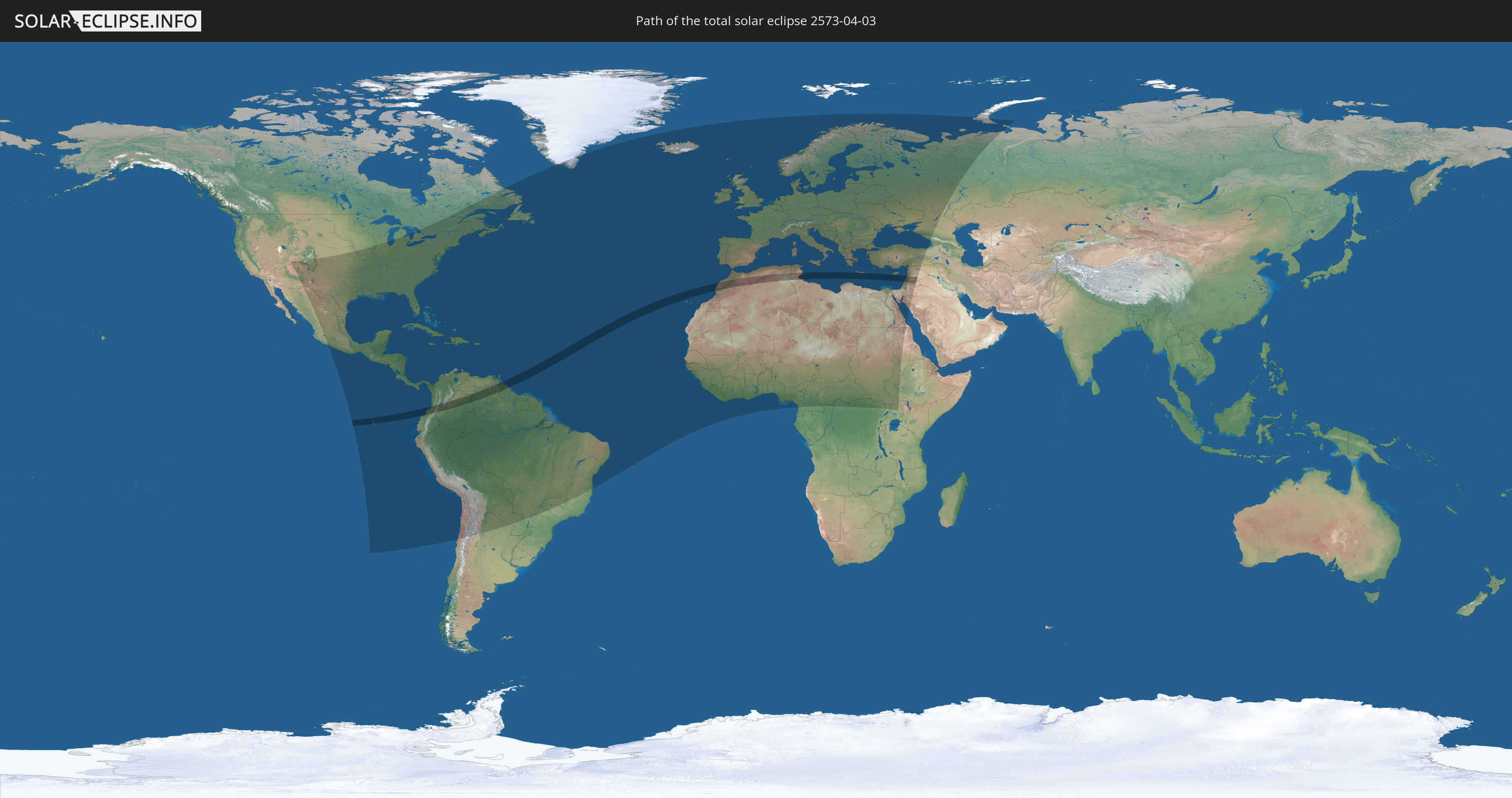
Die Sonnenfinsternis am 03.04.2573 kann man in 140 Ländern als partielle Sonnenfinsternis beobachten.
Der Finsternispfad verläuft durch 14 Länder. Nur in diesen Ländern ist sie als totale Sonnenfinsternis zu sehen.
In den folgenden Ländern ist die Sonnenfinsternis total zu sehen
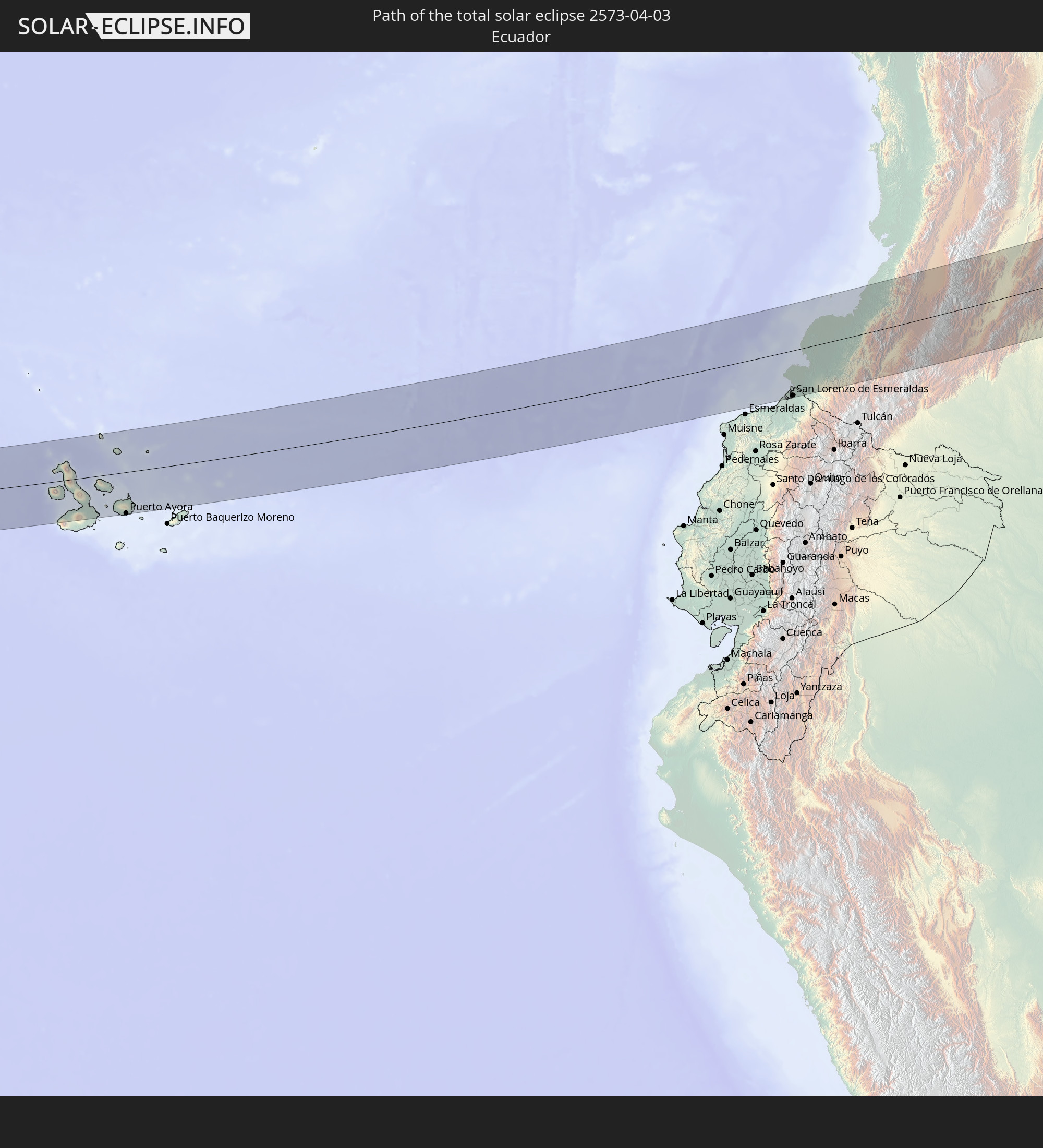 Ecuador
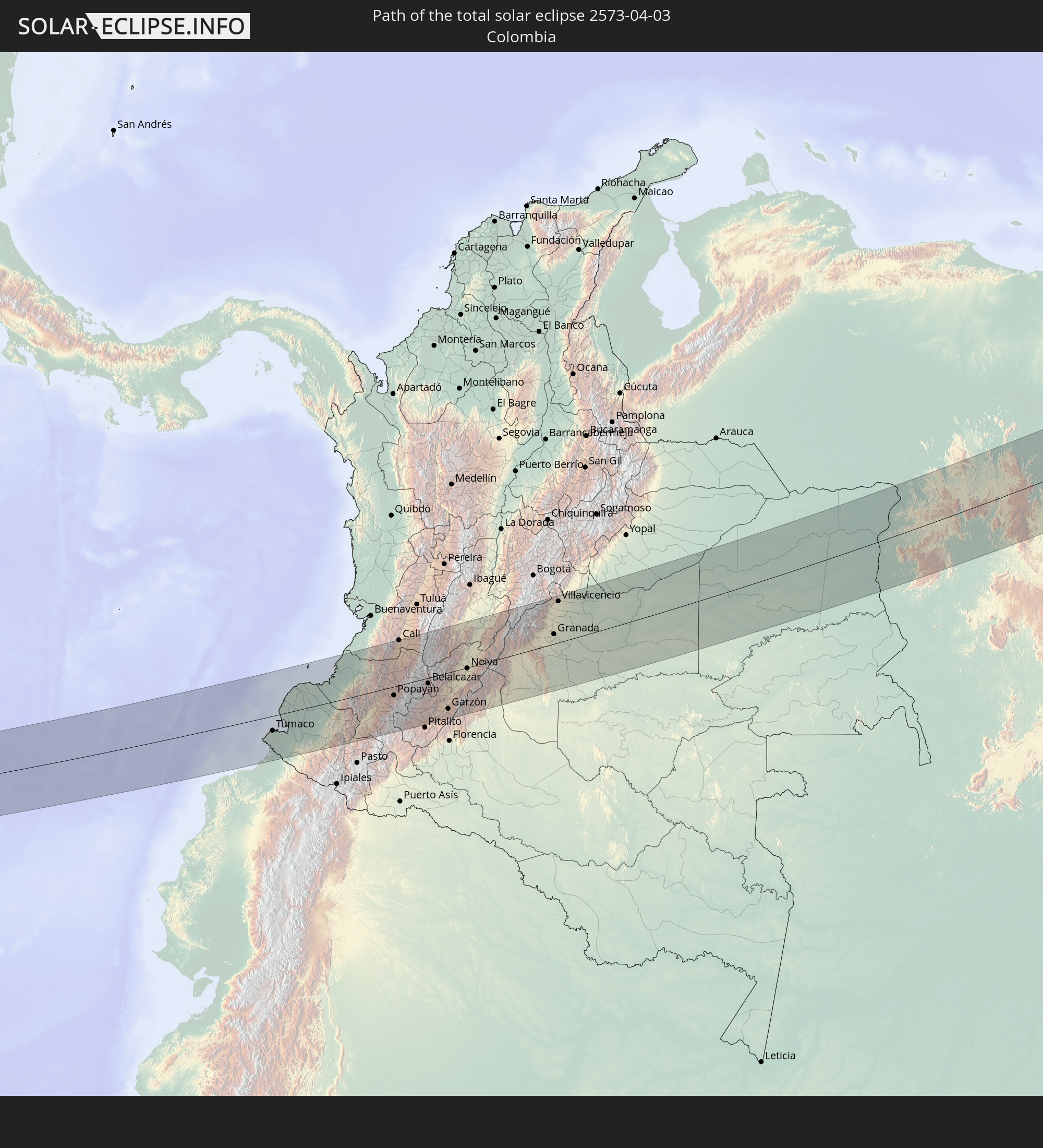 Kolumbien
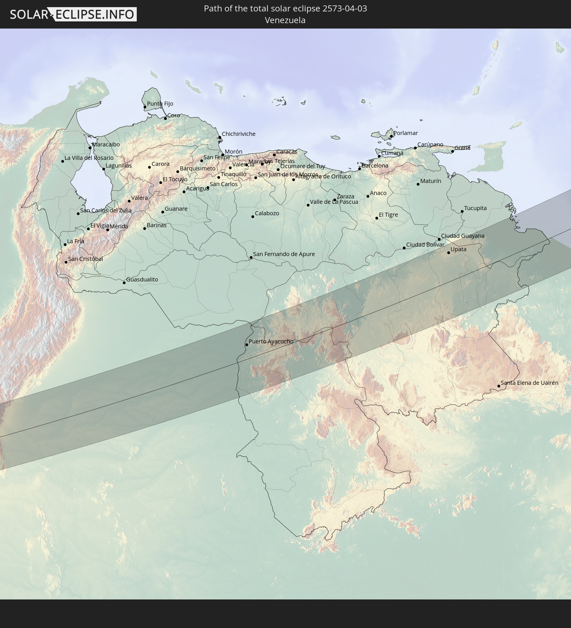 Venezuela
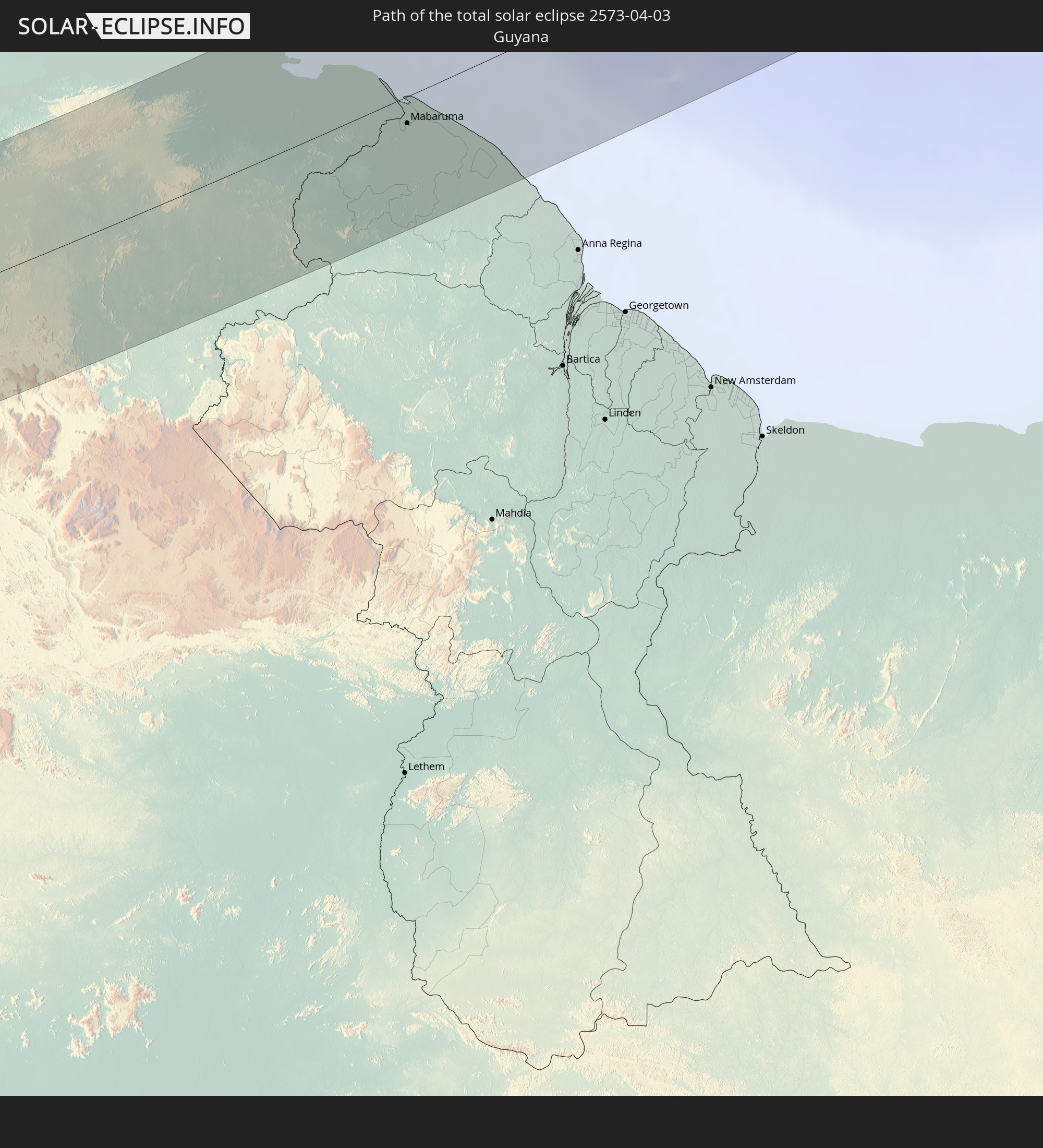 Guyana
 Portugal
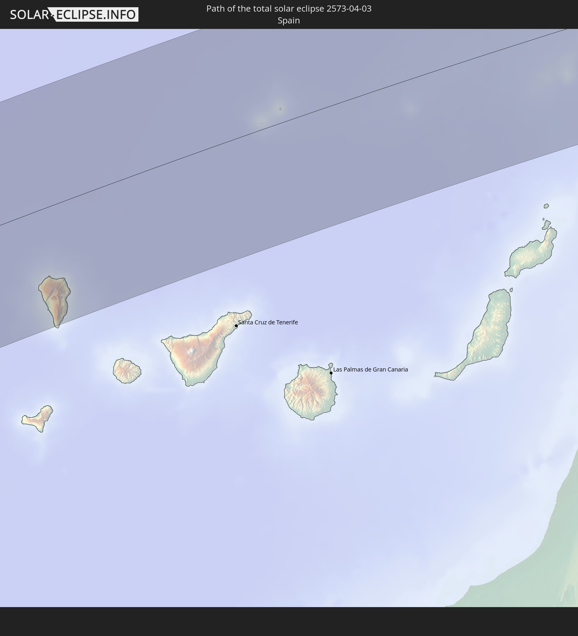 Spanien
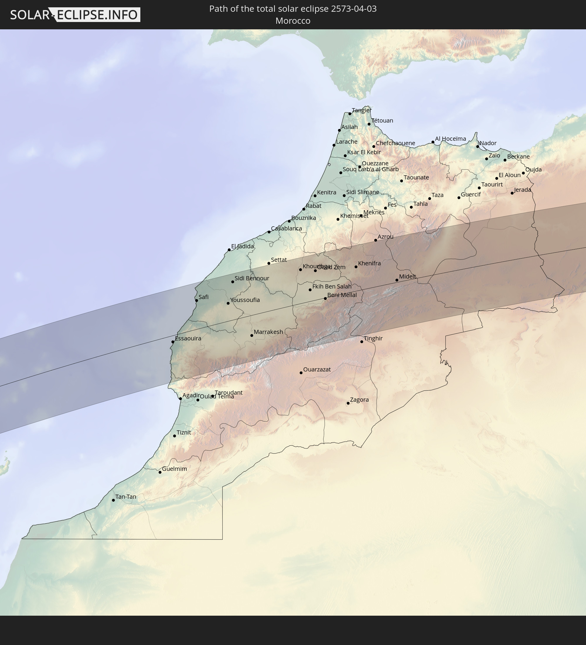 Marokko
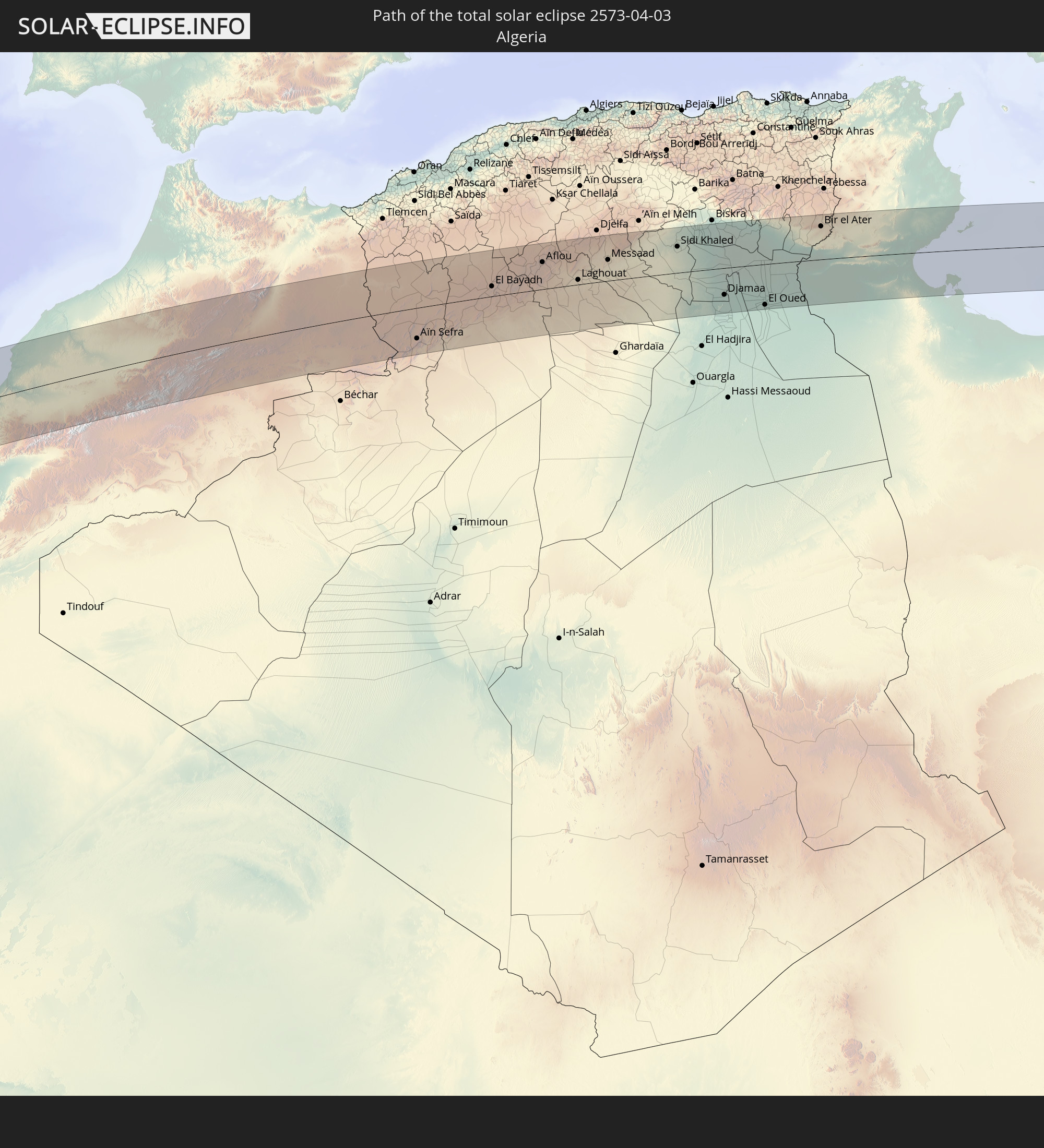 Algerien
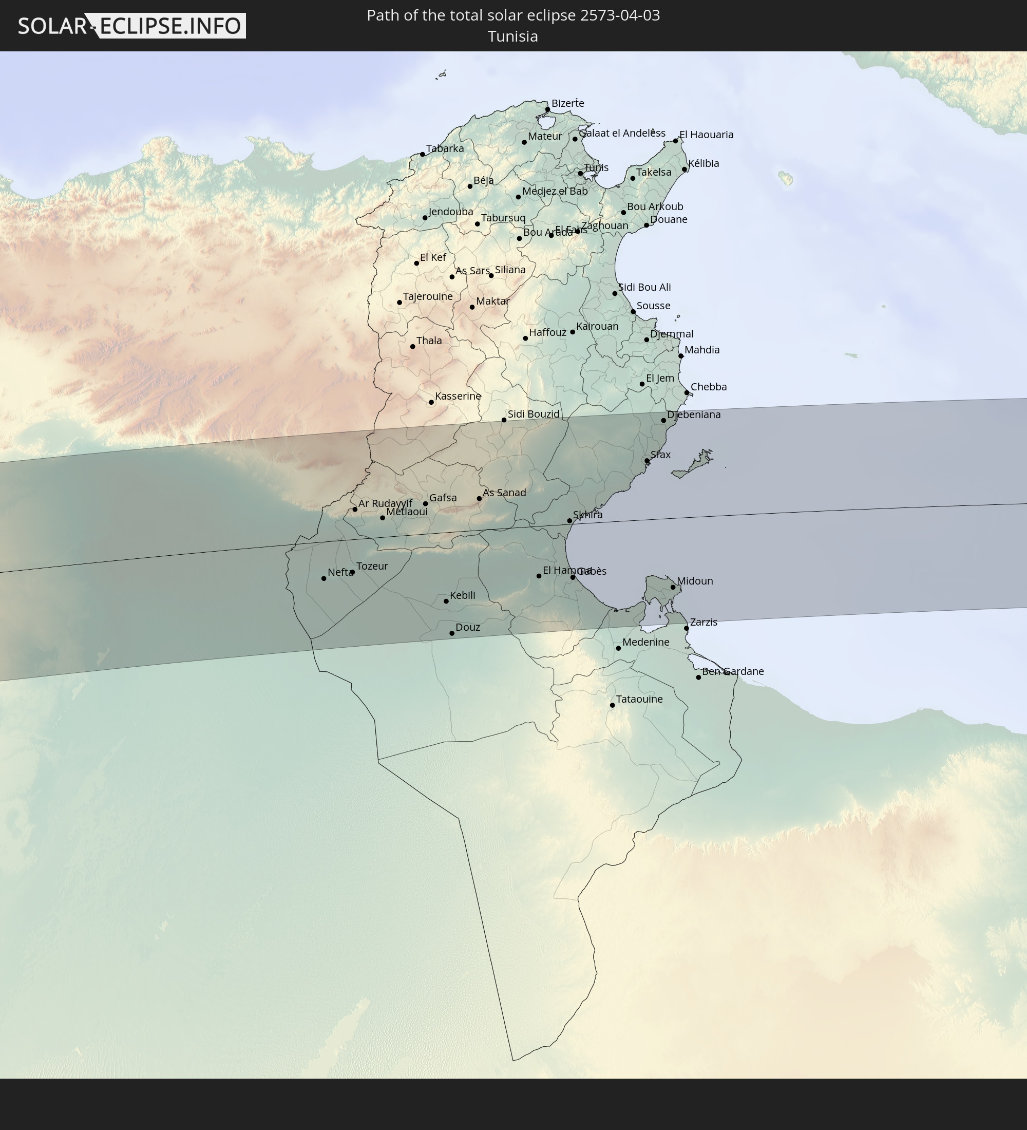 Tunesien
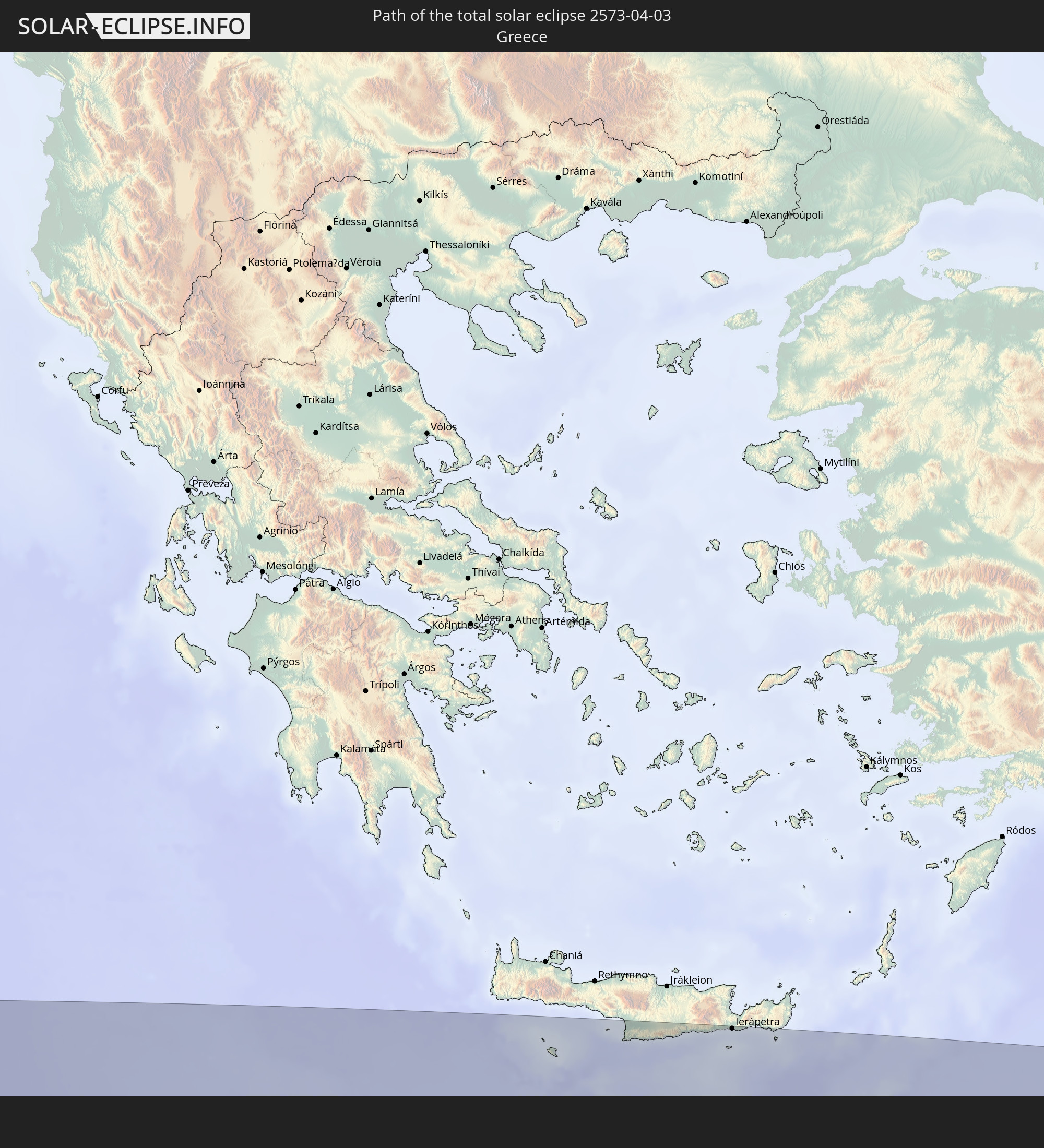 Griechenland
 Israel
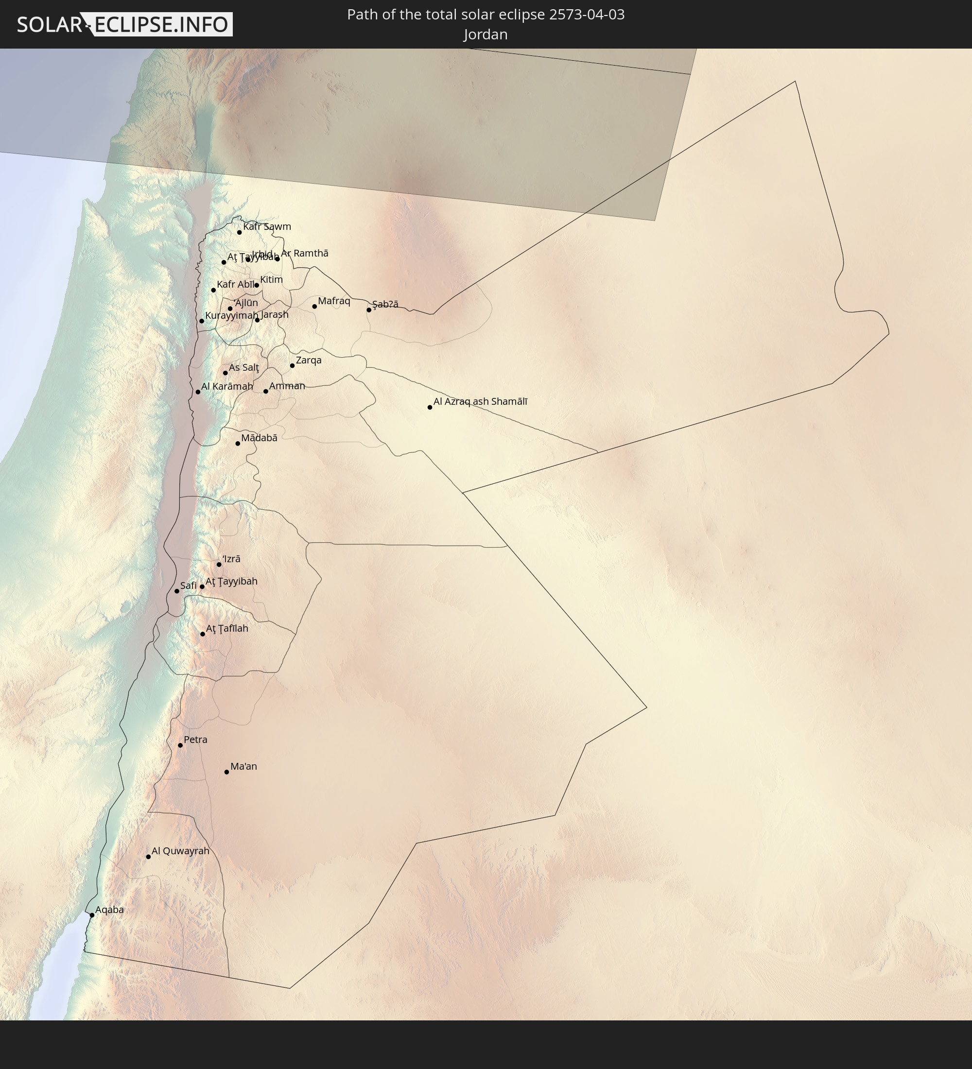 Jordanien
 Libanon
 Syrien
In den folgenden Ländern ist die Sonnenfinsternis partiell zu sehen
 Russland
 Vereinigte Staaten
 United States Minor Outlying Islands
 Kanada
 Mexiko
 Chile
Chile
 Grönland
 Guatemala
 Ecuador
 El Salvador
 Honduras
 Belize
 Nicaragua
 Costa Rica
 Kuba
Kuba
 Panama
 Kolumbien
 Kaimaninseln
 Peru
Peru
 Bahamas
 Jamaika
 Haiti
Haiti
 Brasilien
 Argentinien
 Venezuela
 Turks- und Caicosinseln
 Dominikanische Republik
 Aruba
Aruba
 Bolivien
 Puerto Rico
 Amerikanische Jungferninseln
 Bermuda
 Britische Jungferninseln
 Anguilla
 Saint-Martin
 Saint-Barthélemy
 St. Kitts und Nevis
 Paraguay
 Antigua und Barbuda
 Montserrat
 Trinidad und Tobago
 Guadeloupe
 Grenada
 Dominica
 St. Vincent und die Grenadinen
 Guyana
 Martinique
 St. Lucia
 Barbados
 Suriname
 Saint-Pierre und Miquelon
 Französisch-Guayana
 Portugal
 Kap Verde
 Island
 Spanien
 Senegal
 Mauretanien
 Gambia
 Guinea-Bissau
 Guinea
 Sierra Leone
 Marokko
 Mali
Mali
 Liberia
 Irland
 Algerien
 Vereinigtes Königreich
 Elfenbeinküste
 Färöer
 Burkina Faso
 Gibraltar
 Frankreich
 Isle of Man
 Ghana
Ghana
 Guernsey
 Jersey
 Togo
Togo
 Niger
Niger
 Benin
Benin
 Andorra
 Belgien
 Nigeria
 Niederlande
 Norwegen
 Äquatorialguinea
 Luxemburg
 Deutschland
 Schweiz
 Italien
 Monaco
 Tunesien
 Dänemark
 Kamerun
 Libyen
 Liechtenstein
 Österreich
 Schweden
 Republik Kongo
 Tschechien
 Demokratische Republik Kongo
 San Marino
 Vatikanstadt
 Slowenien
 Tschad
 Kroatien
 Polen
Polen
 Malta
Malta
 Zentralafrikanische Republik
 Bosnien und Herzegowina
 Ungarn
 Slowakei
 Montenegro
 Serbien
 Albanien
 Åland Islands
 Griechenland
 Rumänien
 Mazedonien
 Finnland
 Litauen
 Lettland
 Estland
 Sudan
Sudan
 Ukraine
 Bulgarien
 Weißrussland
 Ägypten
 Türkei
 Moldawien
 Uganda
 Republik Zypern
 Äthiopien
 Staat Palästina
 Israel
 Saudi-Arabien
 Jordanien
 Libanon
 Syrien
 Georgien
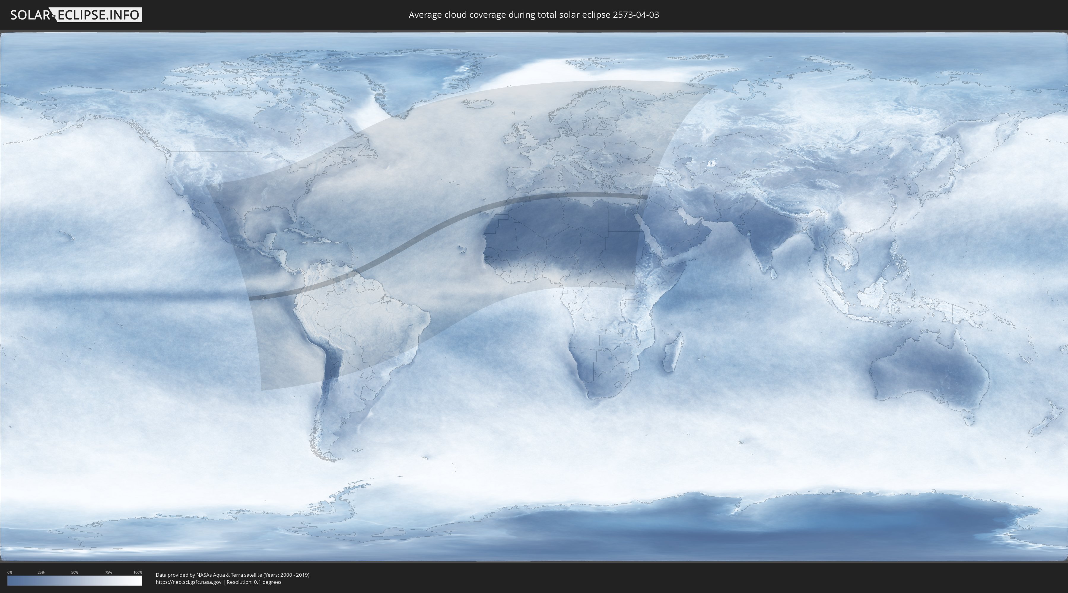
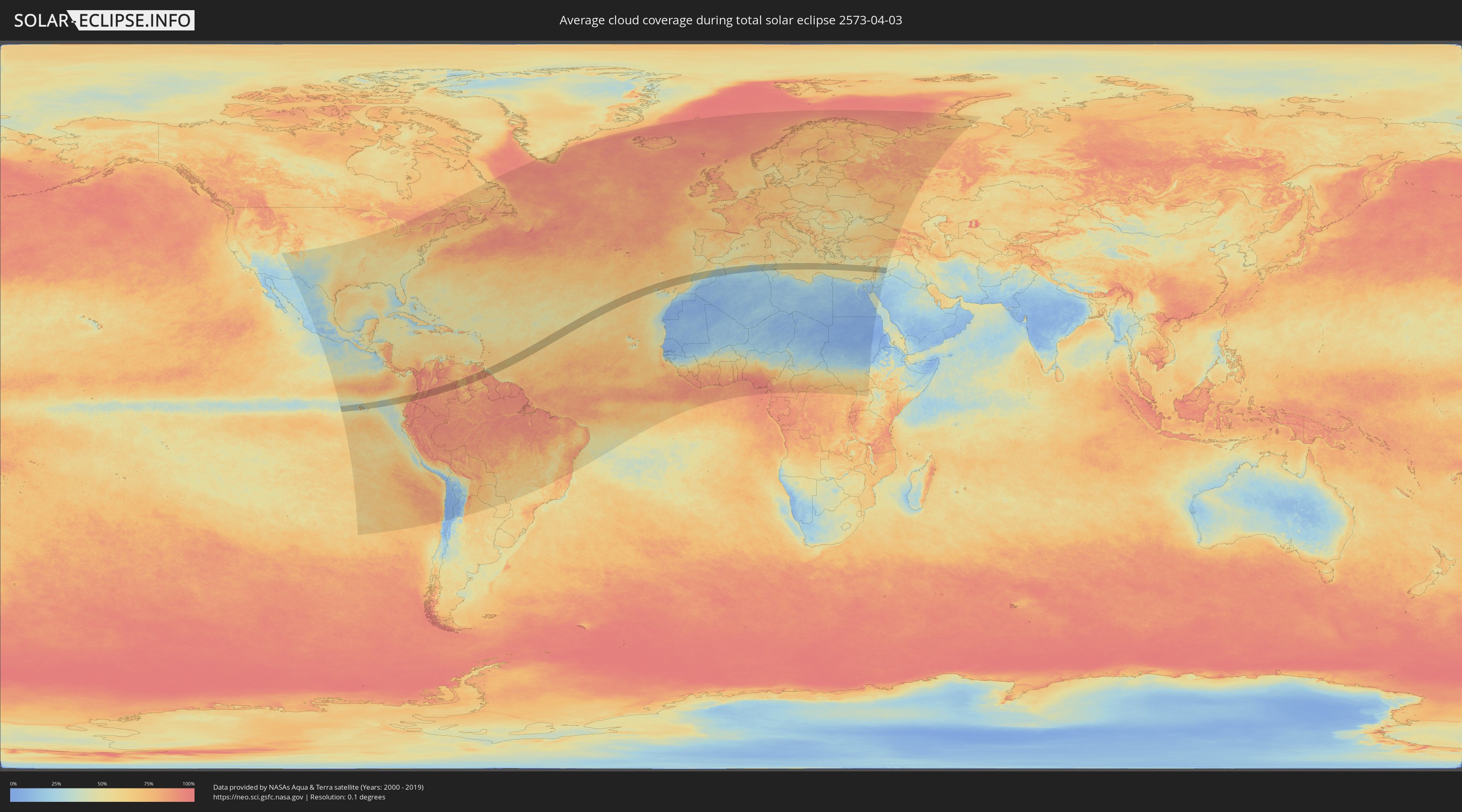
Wie wird das Wetter während der totalen Sonnenfinsternis am 03.04.2573?
Wo ist der beste Ort, um die totale Sonnenfinsternis vom 03.04.2573 zu beobachten?
Die folgenden Karten zeigen die durchschnittliche Bewölkung für den Tag, an dem die totale Sonnenfinsternis
stattfindet. Mit Hilfe der Karten lässt sich der Ort entlang des Finsternispfades eingrenzen,
der die besten Aussichen auf einen klaren wolkenfreien Himmel bietet.
Trotzdem muss man immer lokale Gegenenheiten beachten und sollte sich genau über das Wetter an seinem
gewählten Beobachtungsort informieren.
Die Daten stammen von den beiden NASA-Satelliten
AQUA und TERRA
und wurden über einen Zeitraum von 19 Jahren (2000 - 2019) gemittelt.
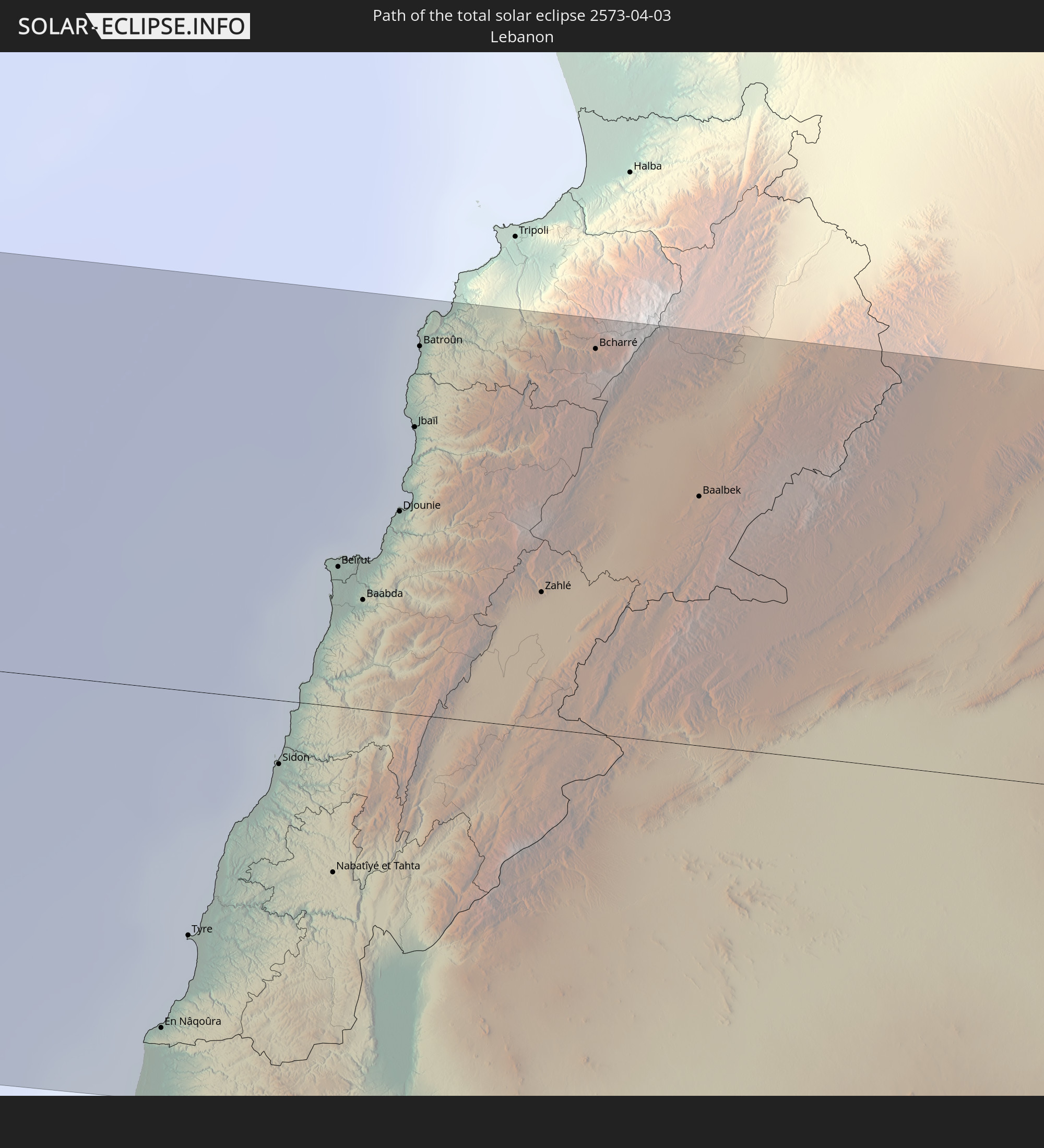
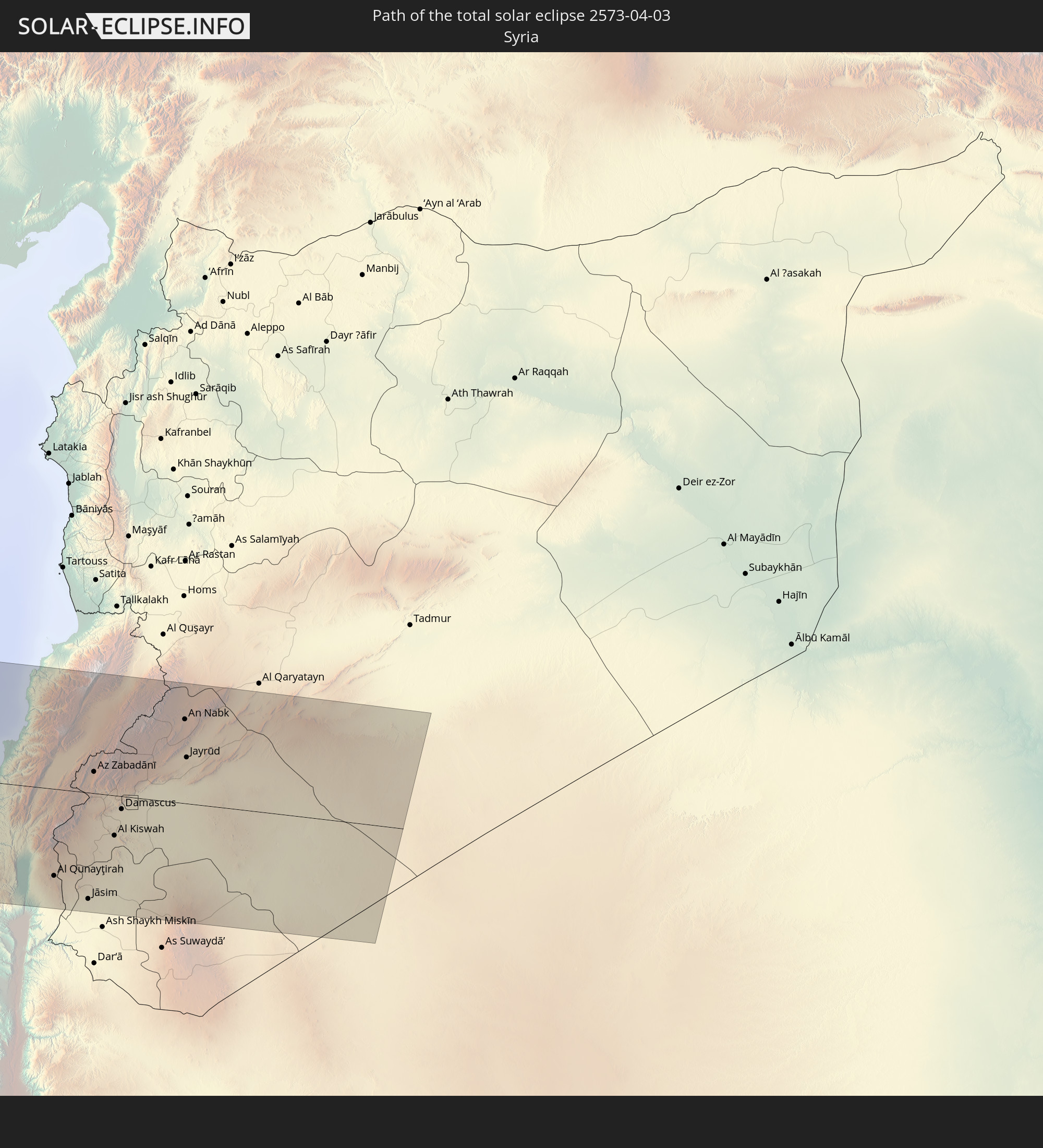
Detaillierte Länderkarten
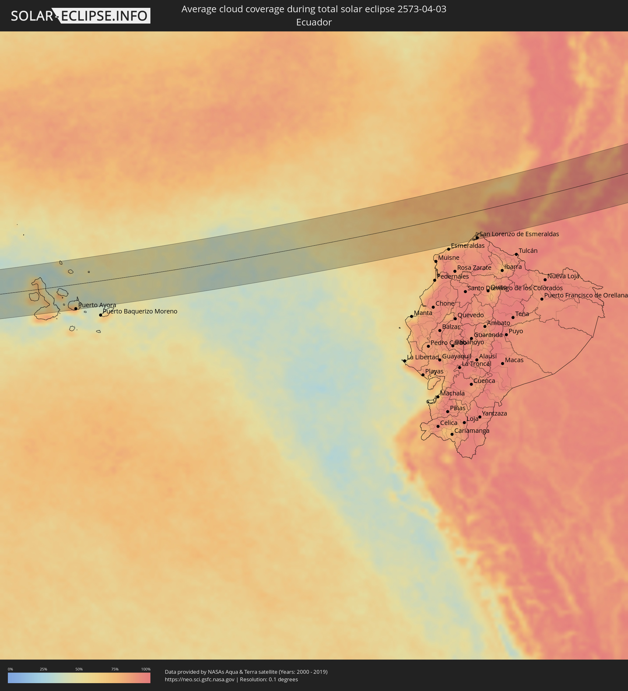 Ecuador
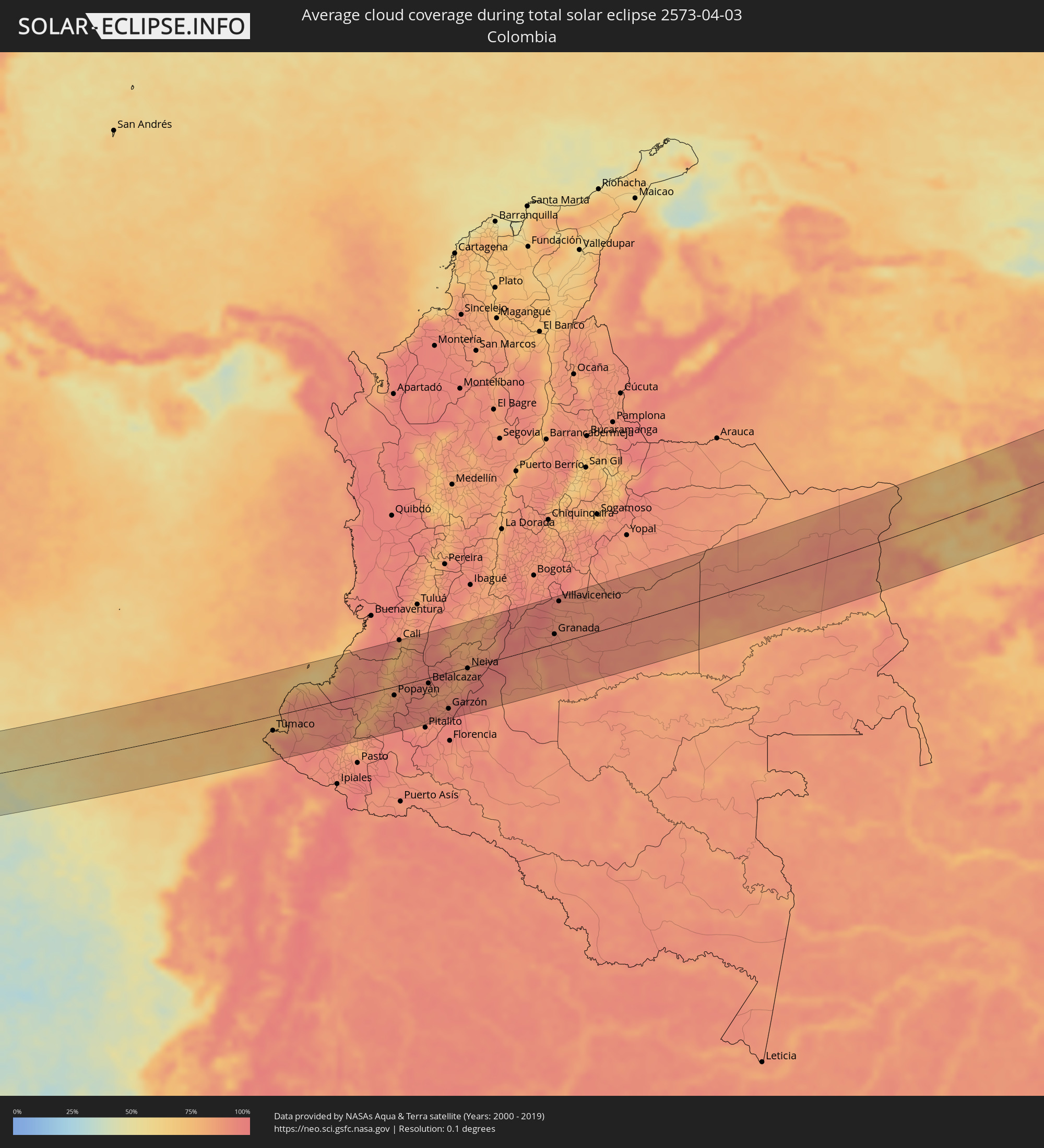 Kolumbien
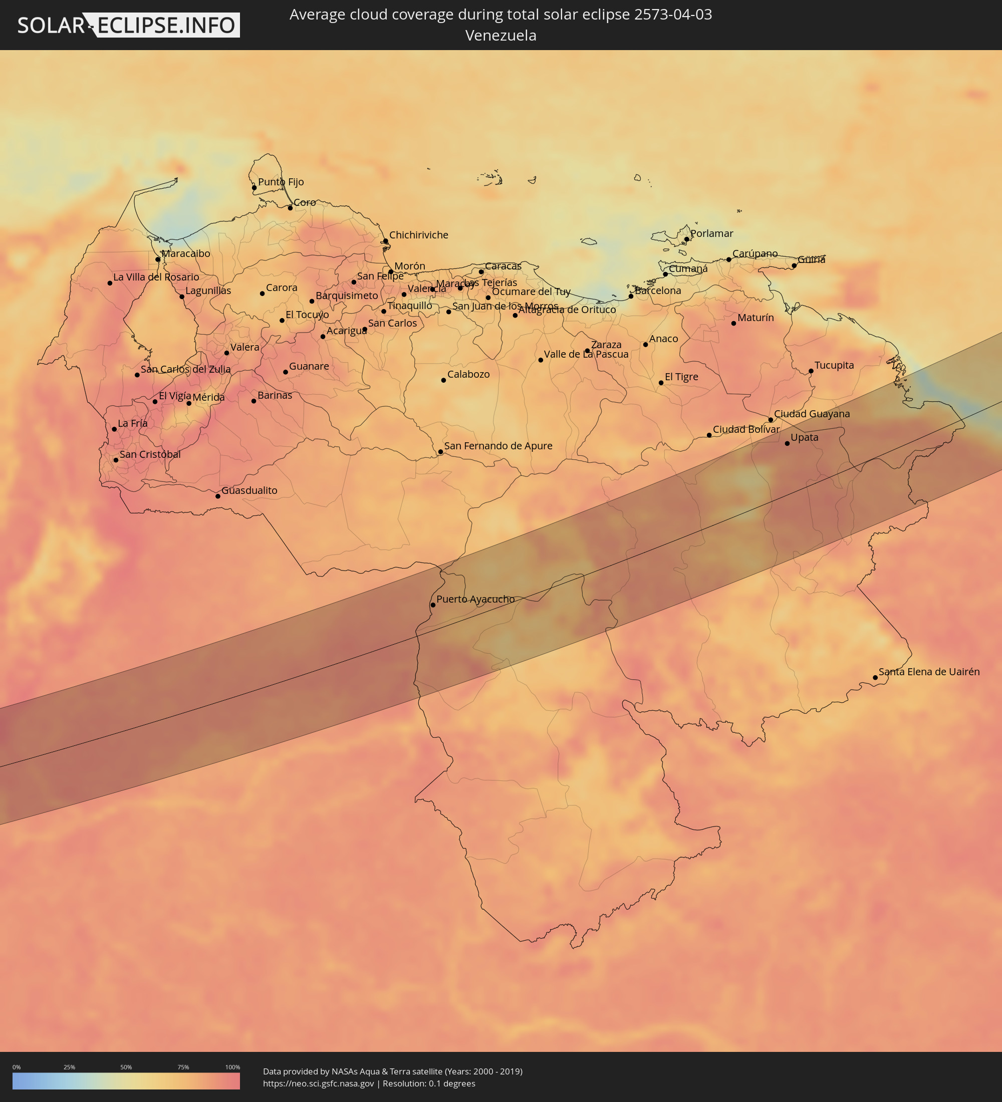 Venezuela
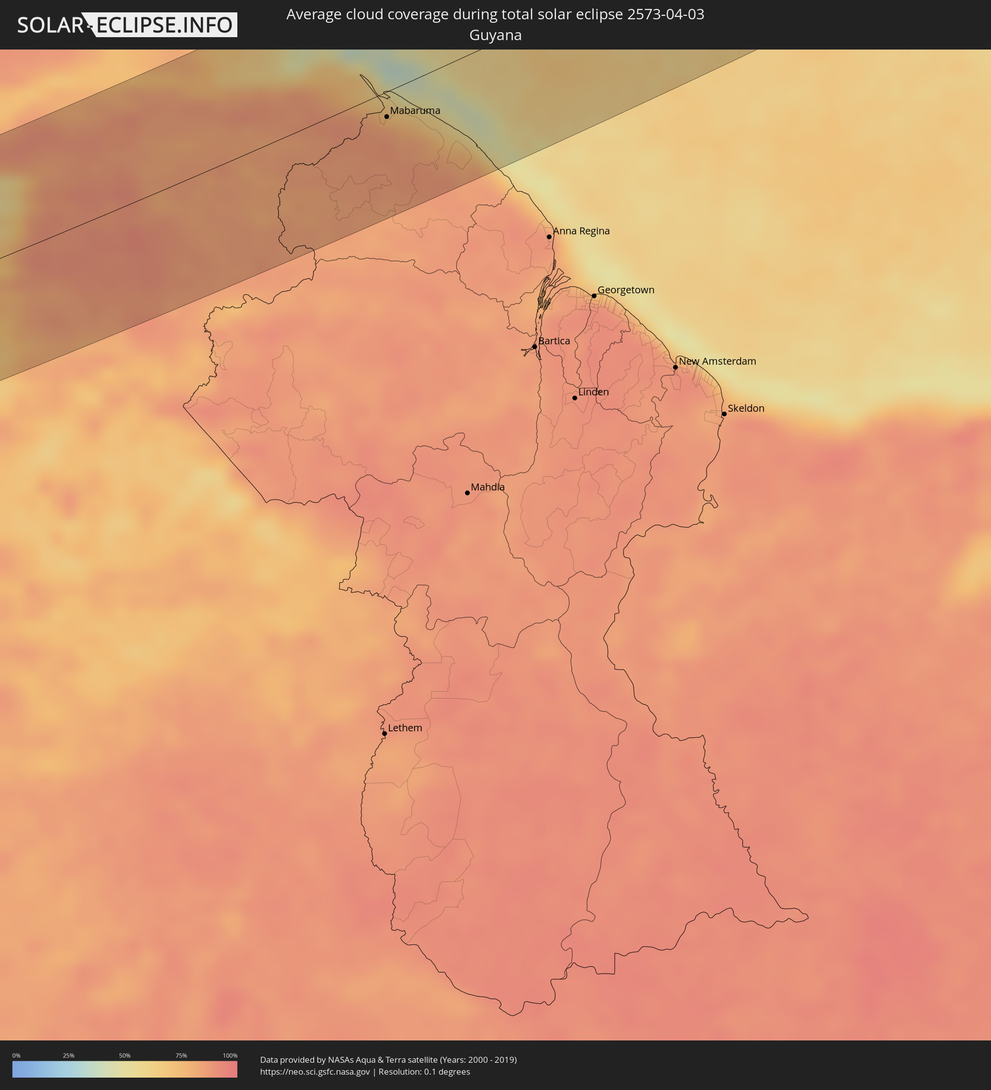 Guyana
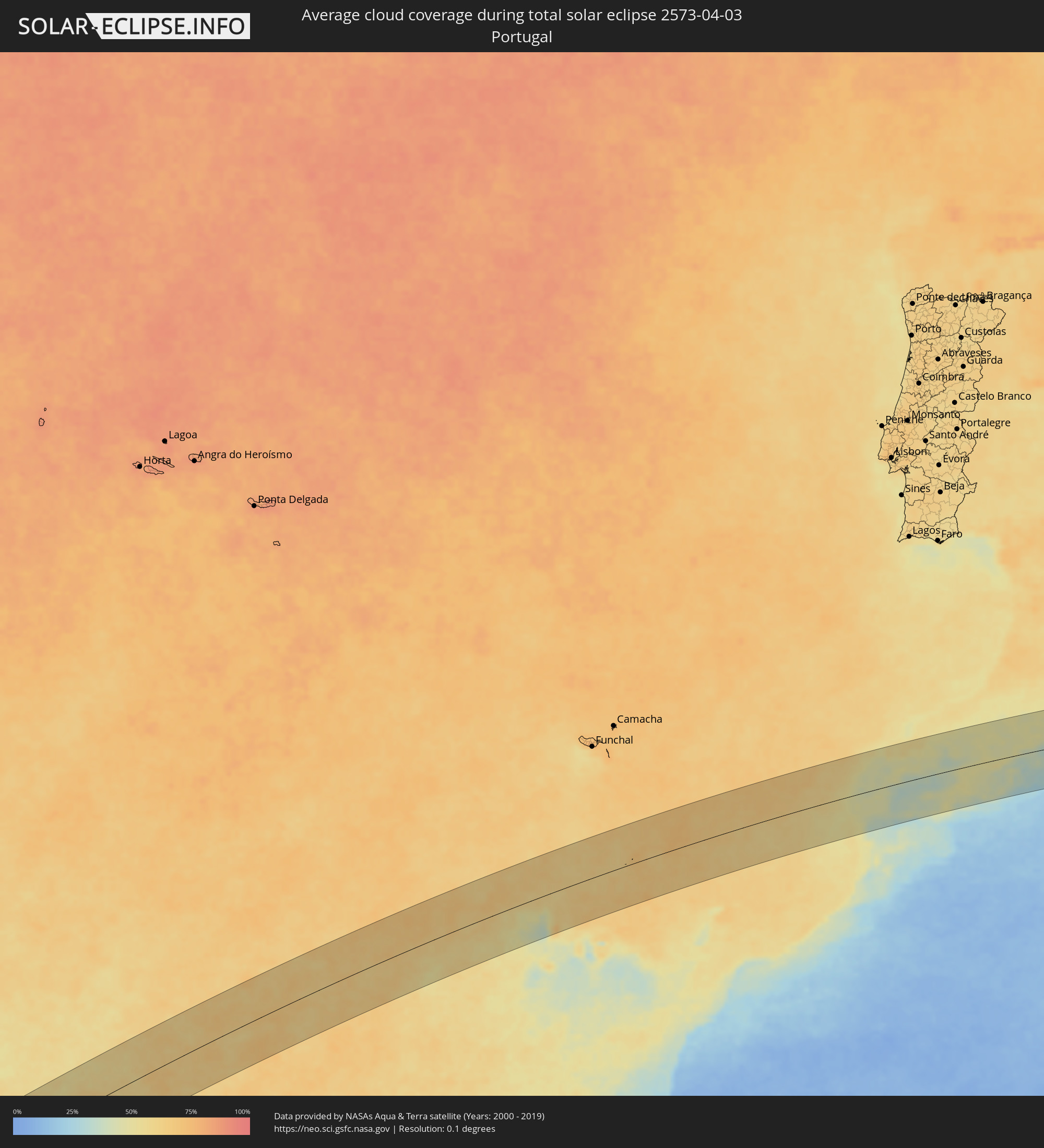 Portugal
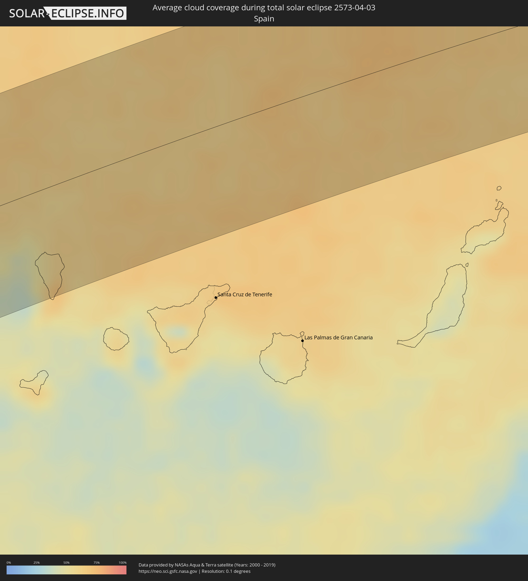 Spanien
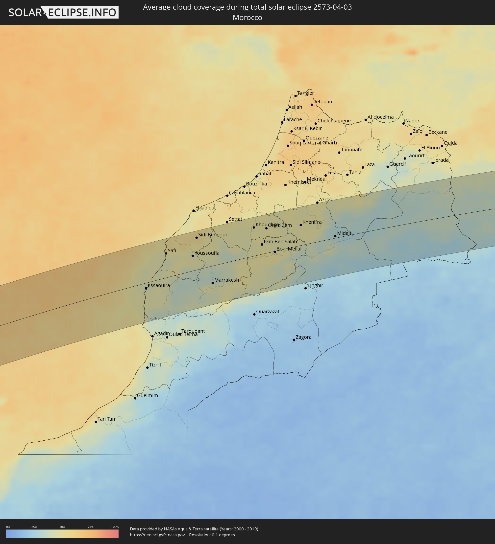 Marokko
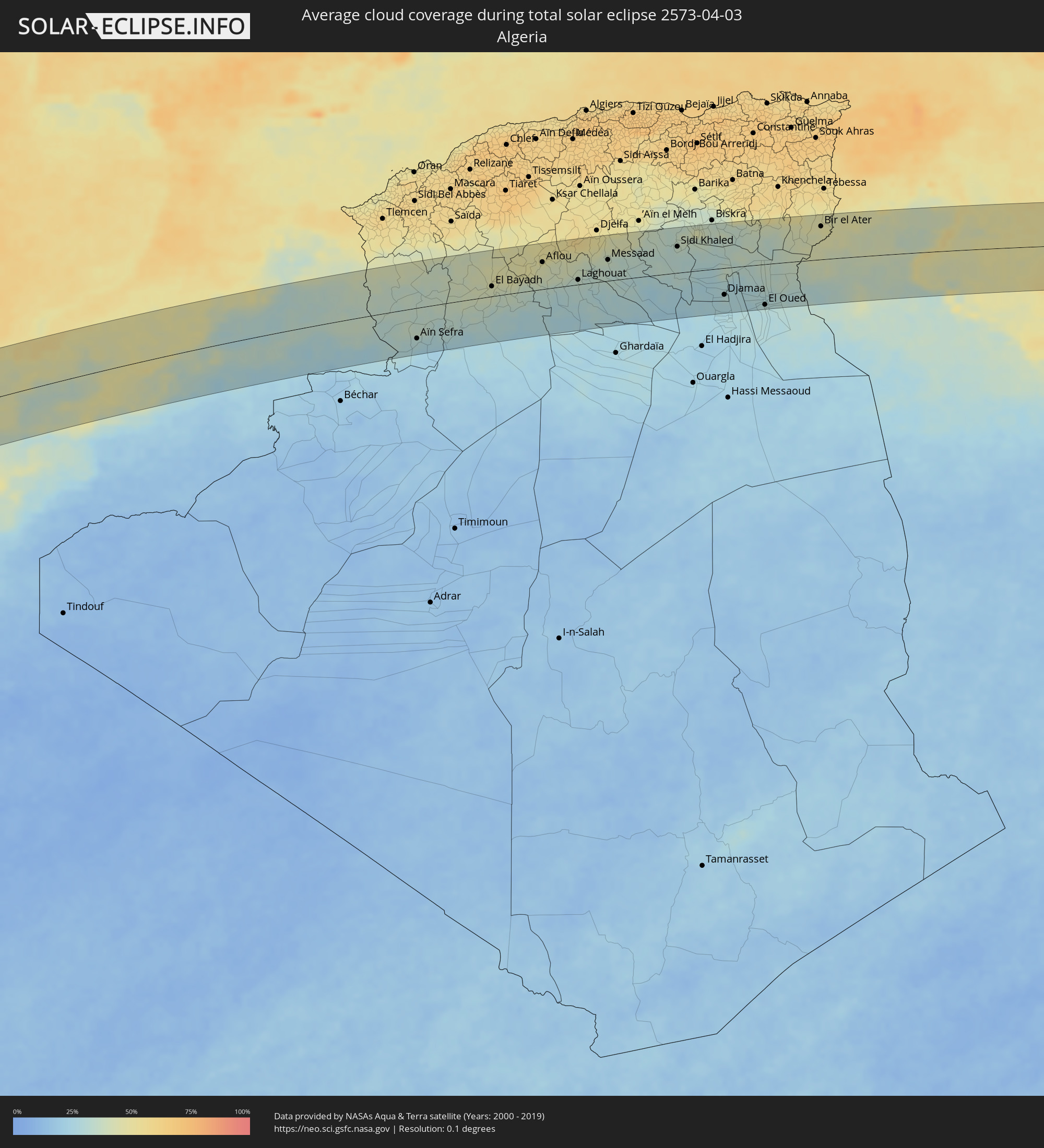 Algerien
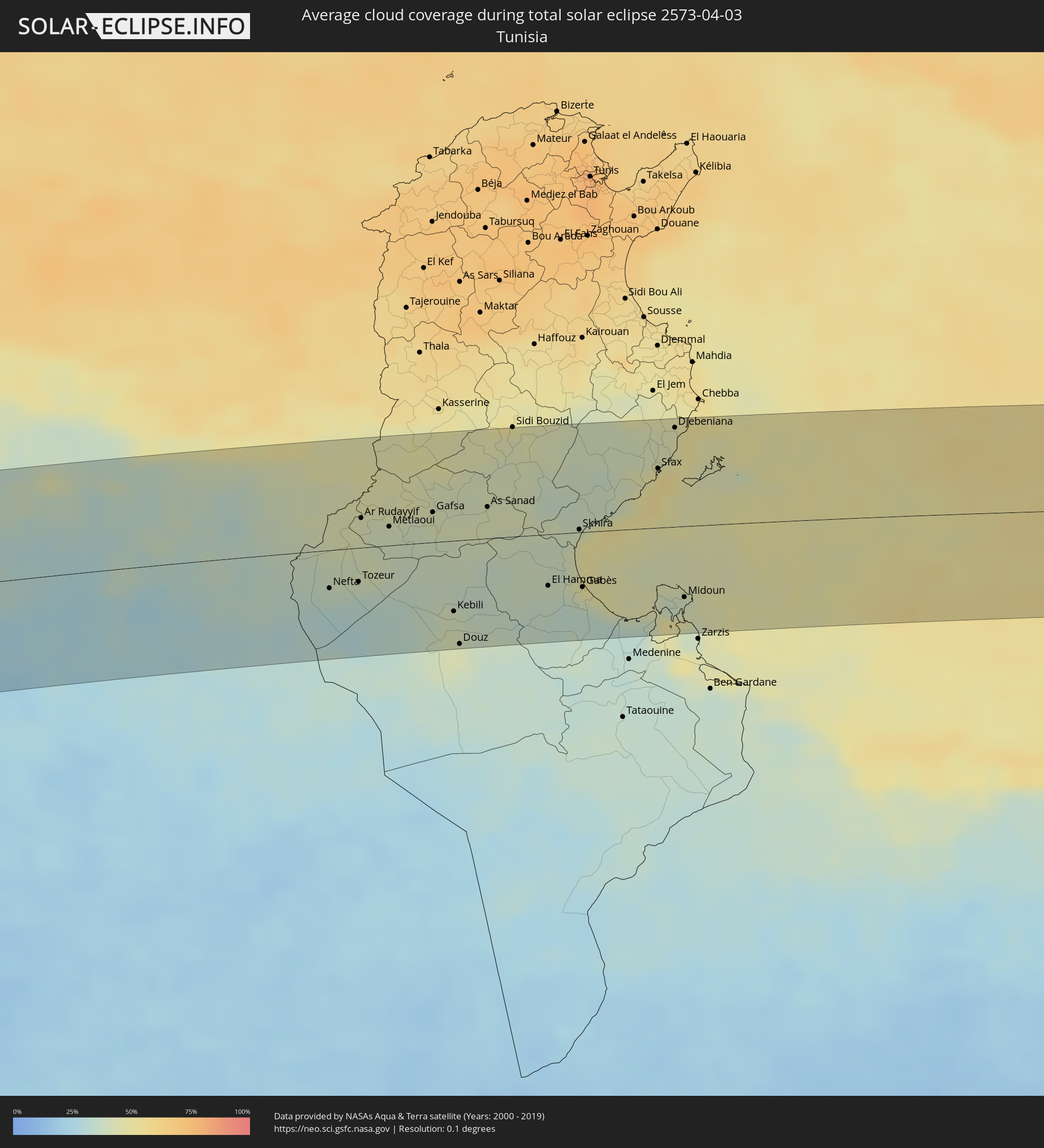 Tunesien
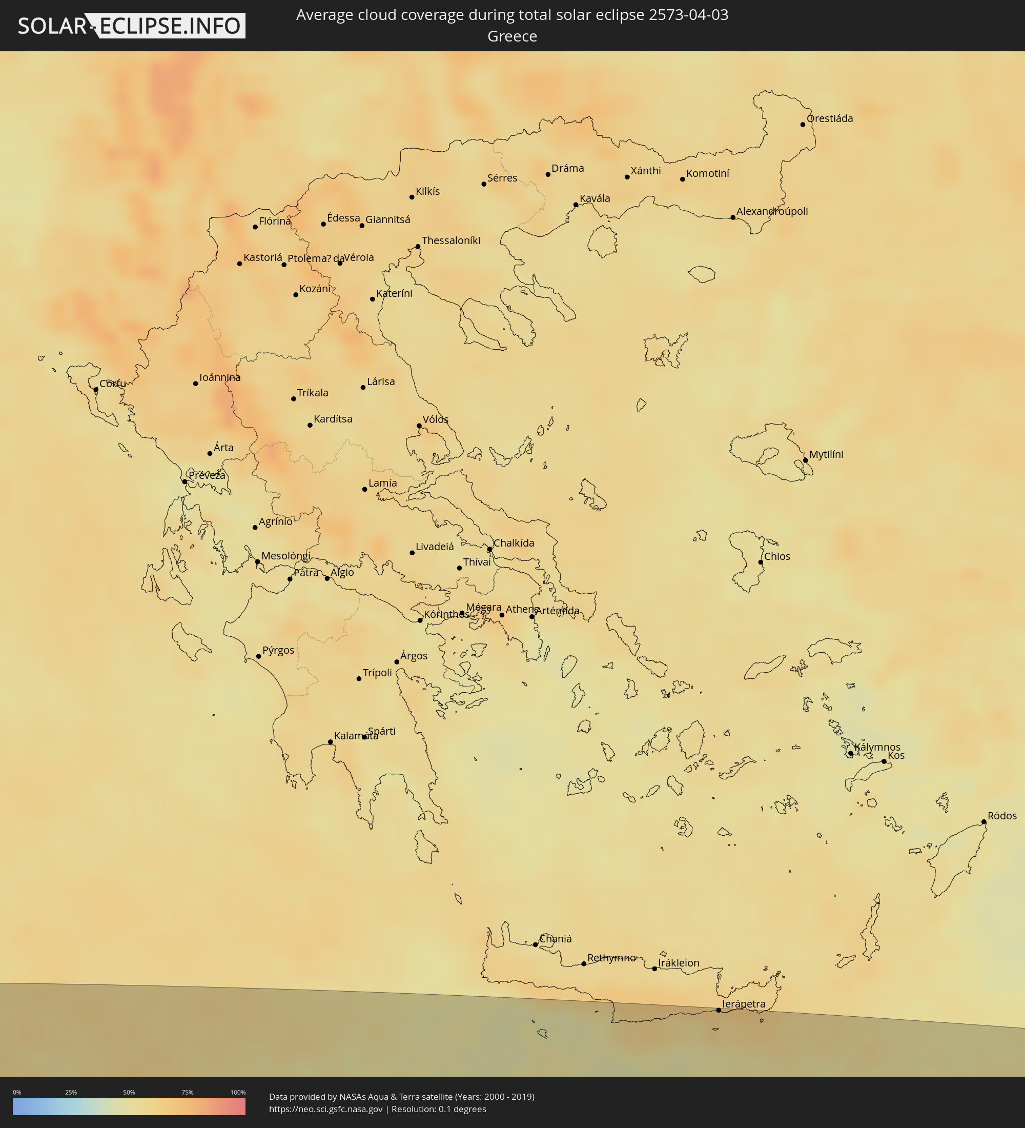 Griechenland
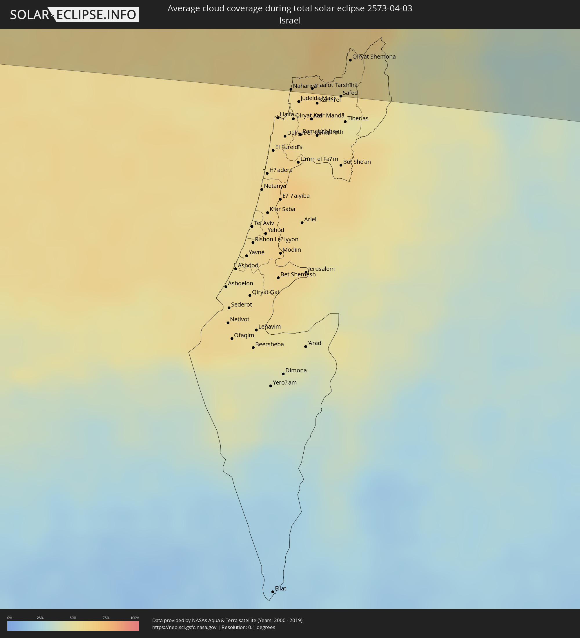 Israel
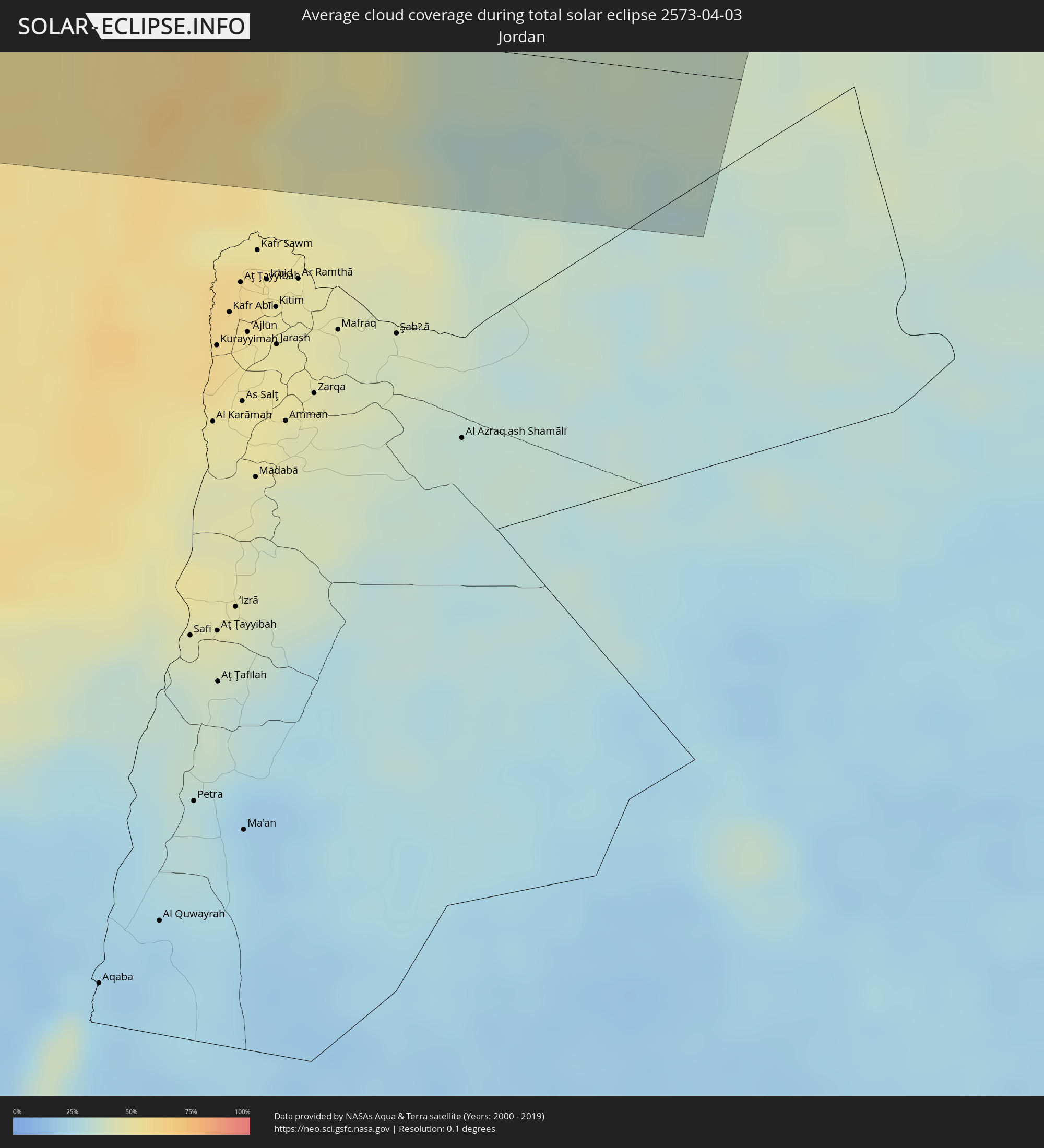 Jordanien
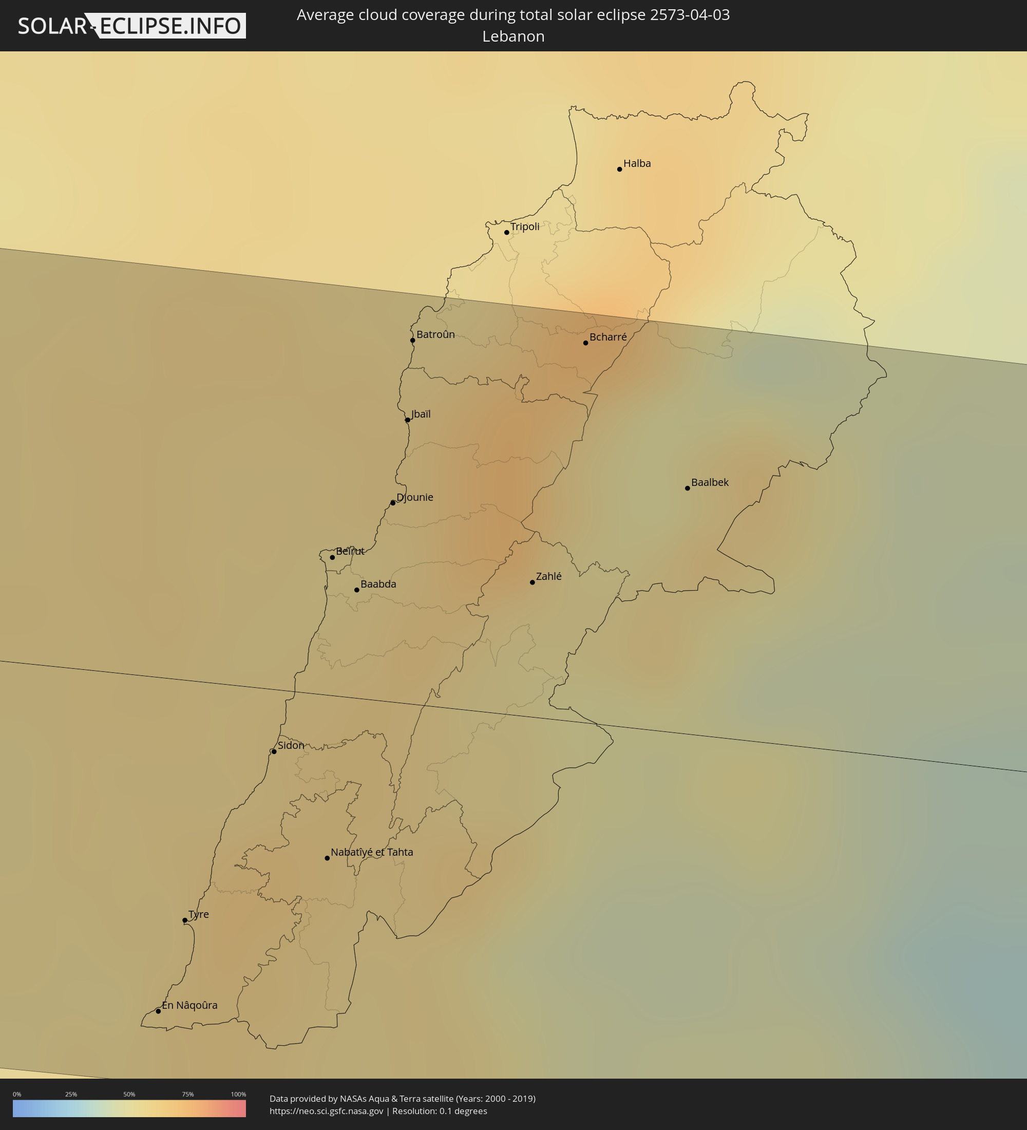 Libanon
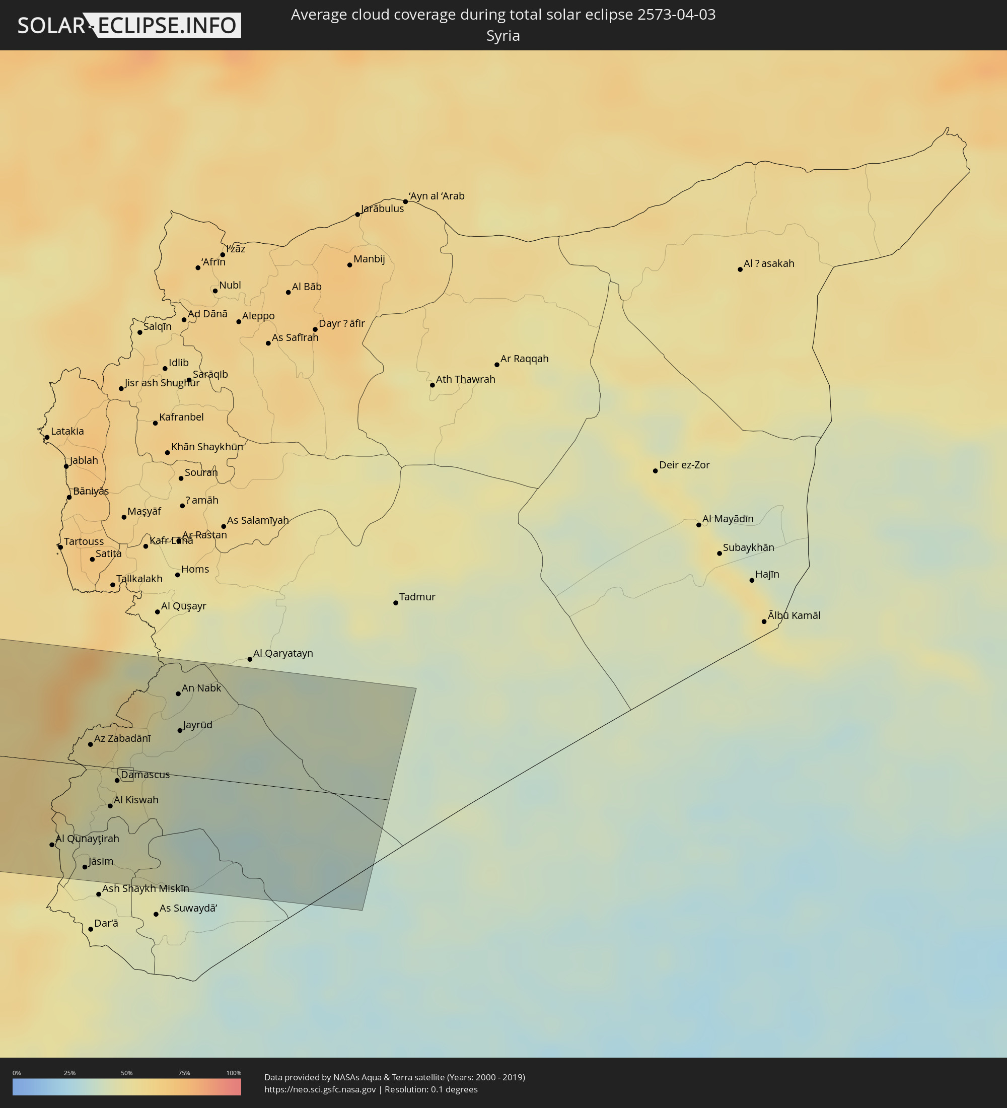 Syrien
Orte im Finsternispfad
Die nachfolgene Tabelle zeigt Städte und Orte mit mehr als 5.000 Einwohnern, die sich im Finsternispfad befinden. Städte mit mehr als 100.000 Einwohnern sind dick gekennzeichnet. Mit einem Klick auf den Ort öffnet sich eine Detailkarte die die Lage des jeweiligen Ortes zusammen mit dem Verlauf der zentralen Finsternis präsentiert.
| Ort | Typ | Dauer der Verfinsterung | Ortszeit bei maximaler Verfinsterung | Entfernung zur Zentrallinie | Ø Bewölkung |
|
Puerto Ayora, Galápagos
|
total | - | 06:27:52 UTC-06:00 | 78 km | 60% |
|
Valdez, Esmeraldas
|
total | - | 07:32:46 UTC-05:00 | 84 km | 78% |
|
San Lorenzo de Esmeraldas, Esmeraldas
|
total | - | 07:32:53 UTC-05:00 | 84 km | 85% |
|
Tumaco, Nariño
|
total | - | 07:33:19 UTC-05:00 | 29 km | 83% |
|
El Charco, Nariño
|
total | - | 07:34:16 UTC-05:00 | 27 km | 85% |
|
Patía, Cauca
|
total | - | 07:34:32 UTC-05:00 | 45 km | 80% |
|
Morales, Cauca
|
total | - | 07:35:25 UTC-05:00 | 17 km | 85% |
|
Popayán, Cauca
|
total | - | 07:35:08 UTC-05:00 | 17 km | 88% |
|
Cali, Valle del Cauca
|
total | - | 07:36:05 UTC-05:00 | 88 km | 79% |
|
Santander de Quilichao, Cauca
|
total | - | 07:35:43 UTC-05:00 | 41 km | 85% |
|
Puerto Tejada, Cauca
|
total | - | 07:35:58 UTC-05:00 | 63 km | 81% |
|
Candelaria, Valle del Cauca
|
total | - | 07:36:10 UTC-05:00 | 80 km | 83% |
|
Florida, Valle del Cauca
|
total | - | 07:36:10 UTC-05:00 | 68 km | 90% |
|
Belalcazar, Cauca
|
total | - | 07:35:43 UTC-05:00 | 11 km | 90% |
|
Garzón, Huila
|
total | - | 07:35:33 UTC-05:00 | 71 km | 94% |
|
Campoalegre, Huila
|
total | - | 07:36:12 UTC-05:00 | 27 km | 90% |
|
Neiva, Huila
|
total | - | 07:36:27 UTC-05:00 | 2 km | 85% |
|
Acacías, Meta
|
total | - | 07:38:33 UTC-05:00 | 67 km | 93% |
|
Granada, Meta
|
total | - | 07:38:10 UTC-05:00 | 19 km | 92% |
|
Villavicencio, Meta
|
total | - | 07:38:48 UTC-05:00 | 80 km | 88% |
|
Puerto Ayacucho, Amazonas
|
total | - | 08:45:54 UTC-04:00 | 38 km | 84% |
|
Upata, Bolívar
|
total | - | 08:54:53 UTC-04:00 | 75 km | 85% |
|
Mabaruma, Barima-Waini
|
total | - | 08:58:46 UTC-04:00 | 20 km | 83% |
|
Tazacorte, Canary Islands
|
total | - | 14:54:41 UTC+00:00 | 78 km | 60% |
|
Los Llanos de Aridane, Canary Islands
|
total | - | 14:54:43 UTC+00:00 | 77 km | 61% |
|
El Paso, Canary Islands
|
total | - | 14:54:47 UTC+00:00 | 79 km | 61% |
|
Breña Alta, Canary Islands
|
total | - | 14:54:59 UTC+00:00 | 82 km | 69% |
|
Garachico, Canary Islands
|
total | - | 14:55:06 UTC+00:00 | 69 km | 63% |
|
Santa Cruz de la Palma, Canary Islands
|
total | - | 14:55:03 UTC+00:00 | 79 km | 69% |
|
Essaouira, Marrakech-Tensift-Al Haouz
|
total | - | 16:10:38 UTC+01:00 | 14 km | 46% |
|
Safi, Doukkala-Abda
|
total | - | 16:11:35 UTC+01:00 | 58 km | 44% |
|
Youssoufia, Doukkala-Abda
|
total | - | 16:12:43 UTC+01:00 | 36 km | 47% |
|
Sidi Bennour, Doukkala-Abda
|
total | - | 16:12:54 UTC+01:00 | 77 km | 55% |
|
Marrakesh, Marrakech-Tensift-Al Haouz
|
total | - | 16:13:31 UTC+01:00 | 43 km | 44% |
|
Khouribga, Chaouia-Ouardigha
|
total | - | 16:15:14 UTC+01:00 | 68 km | 48% |
|
Boujniba, Chaouia-Ouardigha
|
total | - | 16:15:25 UTC+01:00 | 68 km | 48% |
|
Fkih Ben Salah, Tadla-Azilal
|
total | - | 16:15:33 UTC+01:00 | 23 km | 50% |
|
Oued Zem, Chaouia-Ouardigha
|
total | - | 16:15:43 UTC+01:00 | 59 km | 49% |
|
Beni Mellal, Tadla-Azilal
|
total | - | 16:16:04 UTC+01:00 | 2 km | 49% |
|
Ifrane, Tadla-Azilal
|
total | - | 16:16:04 UTC+01:00 | 71 km | 44% |
|
Kasba Tadla, Tadla-Azilal
|
total | - | 16:16:11 UTC+01:00 | 24 km | 46% |
|
Khenifra, Meknès-Tafilalet
|
total | - | 16:17:04 UTC+01:00 | 49 km | 47% |
|
Midelt, Meknès-Tafilalet
|
total | - | 16:18:24 UTC+01:00 | 4 km | 31% |
|
Aïn Sefra, Naama
|
total | - | 16:24:00 UTC+01:00 | 60 km | 31% |
|
El Abiodh Sidi Cheikh, El Bayadh
|
total | - | 16:25:22 UTC+01:00 | 61 km | 25% |
|
El Bayadh, El Bayadh
|
total | - | 16:25:44 UTC+01:00 | 20 km | 41% |
|
Aflou, Laghouat
|
total | - | 16:26:52 UTC+01:00 | 53 km | 44% |
|
El Idrissia, Djelfa
|
total | - | 16:27:14 UTC+01:00 | 85 km | 50% |
|
Laghouat, Laghouat
|
total | - | 16:27:49 UTC+01:00 | 9 km | 33% |
|
’Aïn el Bell, Djelfa
|
total | - | 16:28:02 UTC+01:00 | 65 km | 43% |
|
Messaad, Djelfa
|
total | - | 16:28:23 UTC+01:00 | 41 km | 38% |
|
Sidi Khaled, Biskra
|
total | - | 16:29:51 UTC+01:00 | 51 km | 33% |
|
Tolga, Biskra
|
total | - | 16:30:07 UTC+01:00 | 85 km | 44% |
|
Sidi Okba, Biskra
|
total | - | 16:30:37 UTC+01:00 | 82 km | 39% |
|
Djamaa, Ouargla
|
total | - | 16:31:10 UTC+01:00 | 53 km | 28% |
|
Sidi Amrane, Ouargla
|
total | - | 16:31:12 UTC+01:00 | 57 km | 28% |
|
Reguiba, El Oued
|
total | - | 16:31:51 UTC+01:00 | 56 km | 29% |
|
El Oued, El Oued
|
total | - | 16:32:05 UTC+01:00 | 80 km | 30% |
|
Debila, El Oued
|
total | - | 16:32:07 UTC+01:00 | 63 km | 30% |
|
Nefta, Tawzar
|
total | - | 16:32:50 UTC+01:00 | 31 km | 35% |
|
Bir el Ater, Tébessa
|
total | - | 16:32:38 UTC+01:00 | 65 km | 45% |
|
Tozeur, Tawzar
|
total | - | 16:33:03 UTC+01:00 | 27 km | 34% |
|
Ar Rudayyif, Gafsa
|
total | - | 16:32:52 UTC+01:00 | 24 km | 41% |
|
Degache, Tawzar
|
total | - | 16:33:05 UTC+01:00 | 22 km | 38% |
|
Metlaoui, Gafsa
|
total | - | 16:33:07 UTC+01:00 | 15 km | 39% |
|
Gafsa, Gafsa
|
total | - | 16:33:24 UTC+01:00 | 24 km | 43% |
|
Kebili, Qibilī
|
total | - | 16:33:53 UTC+01:00 | 57 km | 40% |
|
El Golaa, Qibilī
|
total | - | 16:34:00 UTC+01:00 | 82 km | 43% |
|
Douz, Qibilī
|
total | - | 16:34:01 UTC+01:00 | 84 km | 43% |
|
As Sanad, Gafsa
|
total | - | 16:33:48 UTC+01:00 | 25 km | 43% |
|
El Hamma, Qābis
|
total | - | 16:34:30 UTC+01:00 | 41 km | 36% |
|
Skhira, Şafāqis
|
total | - | 16:34:33 UTC+01:00 | 2 km | 49% |
|
Gabès, Qābis
|
total | - | 16:34:45 UTC+01:00 | 44 km | 43% |
|
Sfax, Şafāqis
|
total | - | 16:34:54 UTC+01:00 | 48 km | 56% |
|
Gremda, Şafāqis
|
total | - | 16:34:55 UTC+01:00 | 48 km | 54% |
|
Djebeniana, Şafāqis
|
total | - | 16:34:52 UTC+01:00 | 80 km | 45% |
|
Midoun, Madanīn
|
total | - | 16:35:31 UTC+01:00 | 57 km | 42% |
|
Tympáki, Crete
|
total | - | 17:42:21 UTC+02:00 | 81 km | 57% |
|
Moíres, Crete
|
total | - | 17:42:24 UTC+02:00 | 79 km | 63% |
|
Ierápetra, Crete
|
total | - | 17:42:41 UTC+02:00 | 79 km | 60% |
|
Nahariya, Northern District
|
total | - | 17:45:17 UTC+02:00 | 75 km | 54% |
|
En Nâqoûra, South Governorate
|
total | - | 17:45:13 UTC+02:00 | 63 km | 55% |
|
Shelomi, Northern District
|
total | - | 17:45:15 UTC+02:00 | 68 km | 55% |
|
Tyre, South Governorate
|
total | - | 17:45:08 UTC+02:00 | 45 km | 57% |
|
maalot Tarshīhā, Northern District
|
total | - | 17:45:17 UTC+02:00 | 73 km | 60% |
|
Kefar Weradim, Northern District
|
total | - | 17:45:17 UTC+02:00 | 75 km | 60% |
|
Ḥurfeish, Northern District
|
total | - | 17:45:17 UTC+02:00 | 72 km | 60% |
|
Sidon, South Governorate
|
total | - | 17:44:58 UTC+02:00 | 12 km | 58% |
|
Habboûch, Nabatîyé
|
total | - | 17:45:03 UTC+02:00 | 28 km | 61% |
|
Ra’s Bayrūt, Beyrouth
|
total | - | 17:44:46 UTC+02:00 | 27 km | 55% |
|
Nabatîyé et Tahta, Nabatîyé
|
total | - | 17:45:04 UTC+02:00 | 31 km | 61% |
|
Beirut, Beyrouth
|
total | - | 17:44:47 UTC+02:00 | 26 km | 55% |
|
Baabda, Mont-Liban
|
total | - | 17:44:49 UTC+02:00 | 20 km | 57% |
|
Qiryat Shemona, Northern District
|
total | - | 17:45:10 UTC+02:00 | 49 km | 55% |
|
Djounie, Mont-Liban
|
total | - | 17:44:44 UTC+02:00 | 37 km | 55% |
|
Jbaïl, Mont-Liban
|
total | - | 17:44:39 UTC+02:00 | 53 km | 59% |
|
Batroûn, Liban-Nord
|
total | - | 17:44:34 UTC+02:00 | 68 km | 57% |
|
Al Qunayţirah, Quneitra
|
total | - | 17:45:13 UTC+02:00 | 55 km | 56% |
|
Zahlé, Béqaa
|
total | - | 17:44:48 UTC+02:00 | 25 km | 53% |
|
Bcharré, Liban-Nord
|
total | - | 17:44:34 UTC+02:00 | 71 km | 73% |
|
Jāsim, Daraa
|
total | - | 17:45:18 UTC+02:00 | 68 km | 45% |
|
Qaţanā, Rif-dimashq
|
total | - | 17:45:03 UTC+02:00 | 19 km | 43% |
|
Az Zabadānī, Rif-dimashq
|
total | - | 17:44:53 UTC+02:00 | 14 km | 48% |
|
Inkhil, Daraa
|
total | - | 17:45:17 UTC+02:00 | 64 km | 45% |
|
Aş Şanamayn, Daraa
|
total | - | 17:45:15 UTC+02:00 | 58 km | 45% |
|
Baalbek, Baalbek-Hermel
|
total | - | 17:44:43 UTC+02:00 | 46 km | 54% |
|
Al Kiswah, Rif-dimashq
|
total | - | 17:45:05 UTC+02:00 | 26 km | 43% |
|
Damascus, Dimashq
|
total | - | 17:45:00 UTC+02:00 | 8 km | 45% |
|
At Tall, Rif-dimashq
|
total | - | 17:44:57 UTC+02:00 | 3 km | 49% |
|
Ḩarastā, Rif-dimashq
|
total | - | 17:44:58 UTC+02:00 | 2 km | 50% |
|
‘Irbīn, Rif-dimashq
|
total | - | 17:44:59 UTC+02:00 | 4 km | 48% |
|
Şalākhid, As-Suwayda
|
total | - | 17:45:22 UTC+02:00 | 76 km | 45% |
|
Al Quţayfah, Rif-dimashq
|
total | - | 17:44:52 UTC+02:00 | 20 km | 42% |
|
Yabrūd, Rif-dimashq
|
total | - | 17:44:44 UTC+02:00 | 46 km | 43% |
|
An Nabk, Rif-dimashq
|
total | - | 17:44:42 UTC+02:00 | 53 km | 43% |
|
Jayrūd, Rif-dimashq
|
total | - | 17:44:49 UTC+02:00 | 29 km | 42% |
|
Qārah, Rif-dimashq
|
total | - | 17:44:37 UTC+02:00 | 68 km | 45% |