Total solar eclipse of 06/08/-0045
| Day of week: | Tuesday |
| Maximum duration of eclipse: | 05m37s |
| Maximum width of eclipse path: | 253 km |
| Saros cycle: | 75 |
| Coverage: | 100% |
| Magnitude: | 1.0731 |
| Gamma: | 0.3449 |
Wo kann man die Sonnenfinsternis vom 06/08/-0045 sehen?
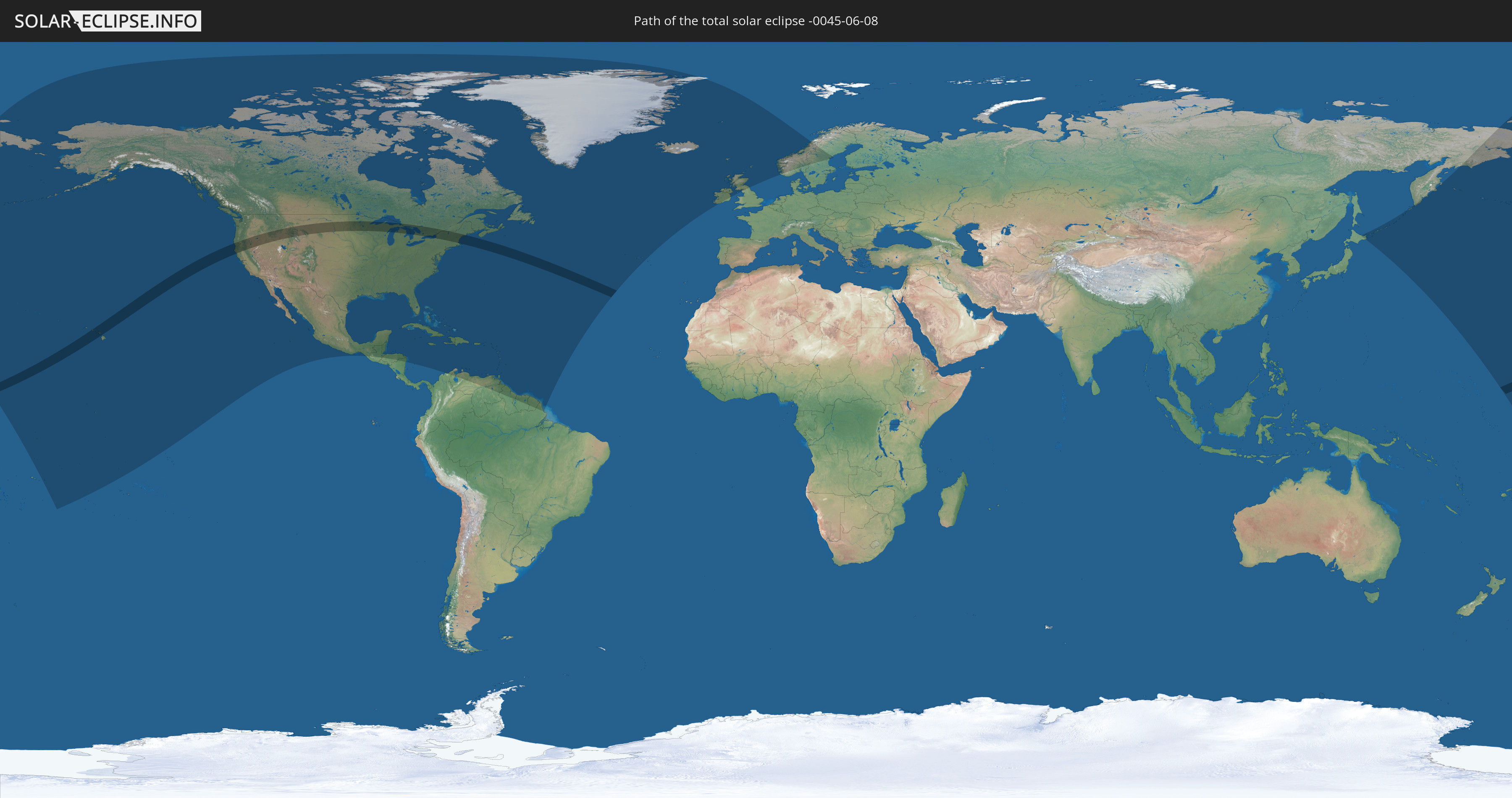
Die Sonnenfinsternis am 06/08/-0045 kann man in 57 Ländern als partielle Sonnenfinsternis beobachten.
Der Finsternispfad verläuft durch 2 Länder. Nur in diesen Ländern ist sie als total Sonnenfinsternis zu sehen.
In den folgenden Ländern ist die Sonnenfinsternis total zu sehen
 United States
 Canada
In den folgenden Ländern ist die Sonnenfinsternis partiell zu sehen
 Russia
 United States
 United States Minor Outlying Islands
 Kiribati
 Tokelau
 American Samoa
 Cook Islands
 Canada
 Mexico
 Greenland
 Guatemala
 Honduras
 Belize
 Nicaragua
 Cuba
Cuba
 Colombia
 Cayman Islands
 The Bahamas
 Jamaica
 Haiti
Haiti
 Brazil
 Venezuela
 Turks and Caicos Islands
 Dominican Republic
 Aruba
Aruba
 Puerto Rico
 United States Virgin Islands
 Bermuda
 British Virgin Islands
 Anguilla
 Collectivity of Saint Martin
 Saint Barthélemy
 Saint Kitts and Nevis
 Antigua and Barbuda
 Montserrat
 Trinidad and Tobago
 Guadeloupe
 Grenada
 Dominica
 Saint Vincent and the Grenadines
 Guyana
 Martinique
 Saint Lucia
 Barbados
 Suriname
 Saint Pierre and Miquelon
 French Guiana
 Portugal
 Iceland
 Republic of Ireland
 Svalbard and Jan Mayen
 United Kingdom
 Faroe Islands
 Isle of Man
 Norway
 Sweden
 Japan
Japan
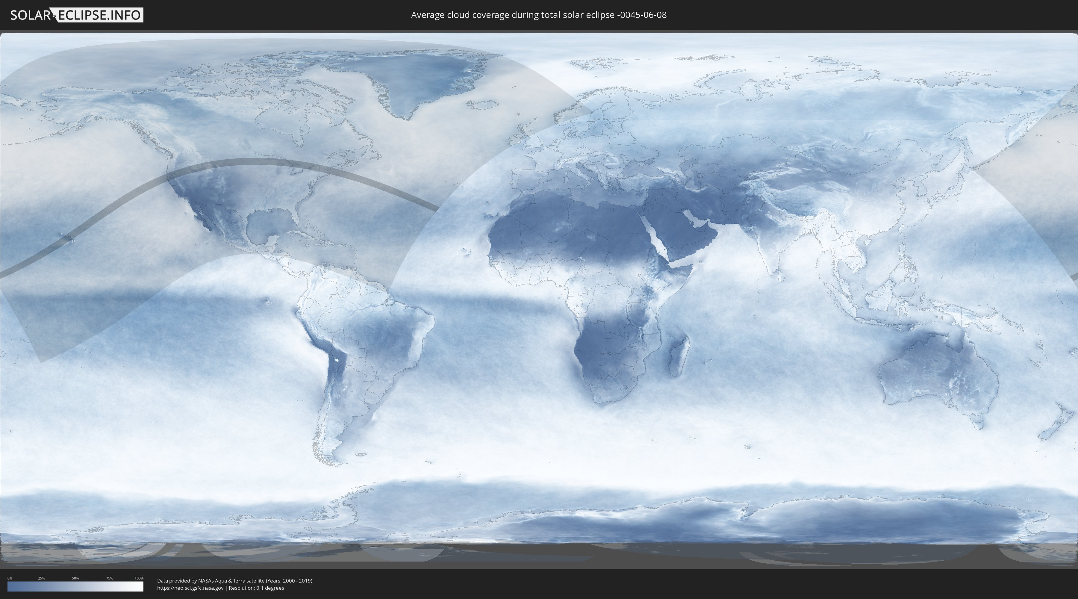
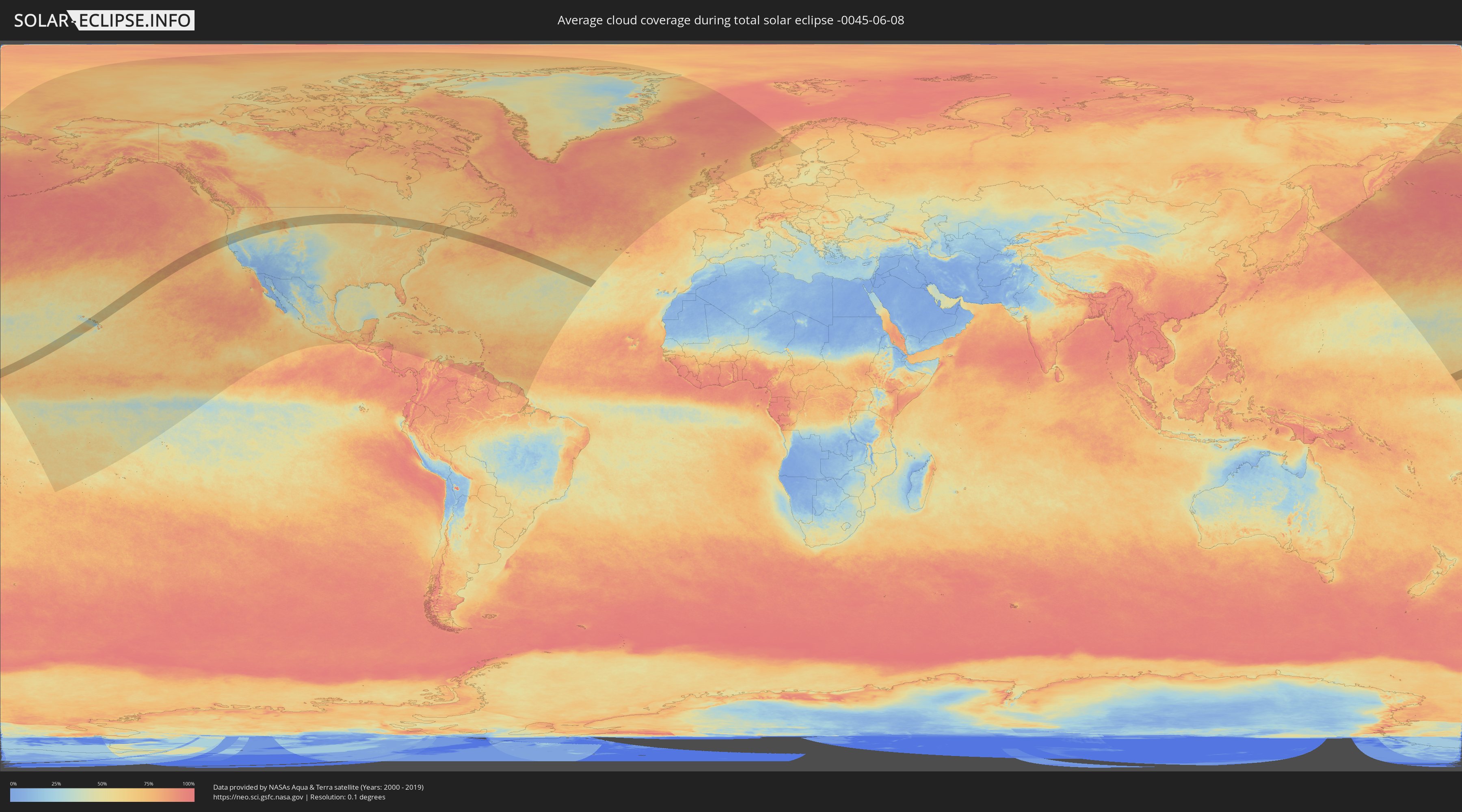
How will be the weather during the total solar eclipse on 06/08/-0045?
Where is the best place to see the total solar eclipse of 06/08/-0045?
The following maps show the average cloud coverage for the day of the total solar eclipse.
With the help of these maps, it is possible to find the place along the eclipse path, which has the best
chance of a cloudless sky.
Nevertheless, you should consider local circumstances and inform about the weather of your chosen
observation site.
The data is provided by NASAs satellites
AQUA and TERRA.
The cloud maps are averaged over a period of 19 years (2000 - 2019).
Detailed country maps
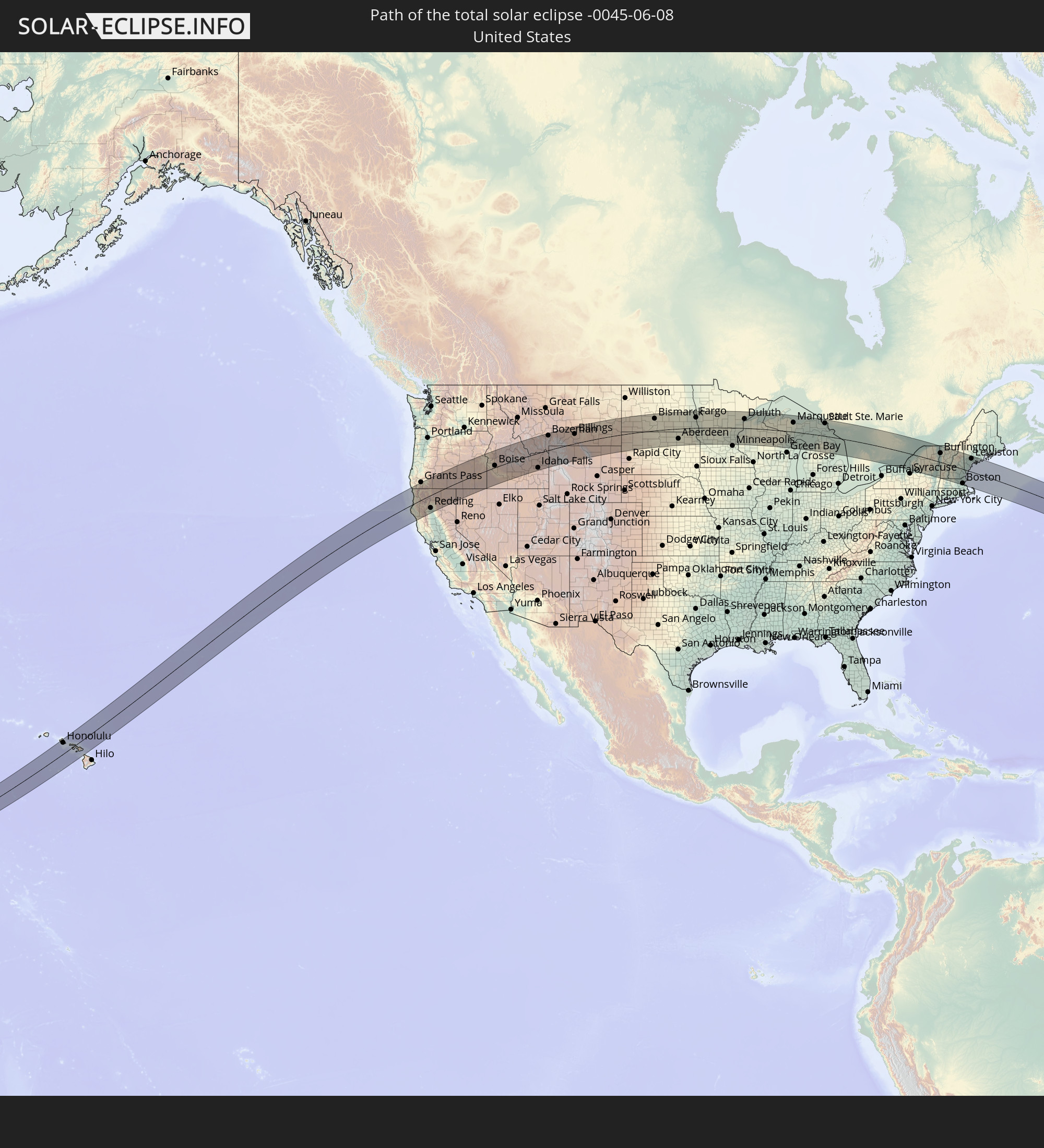
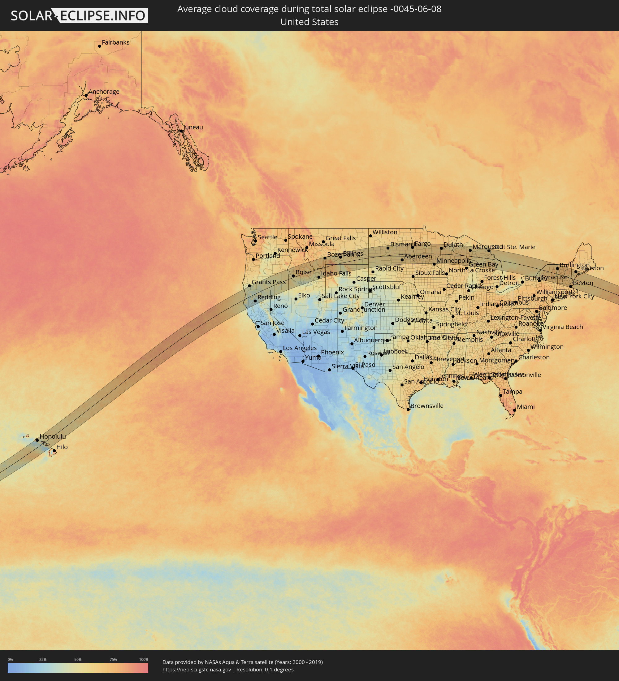 United States
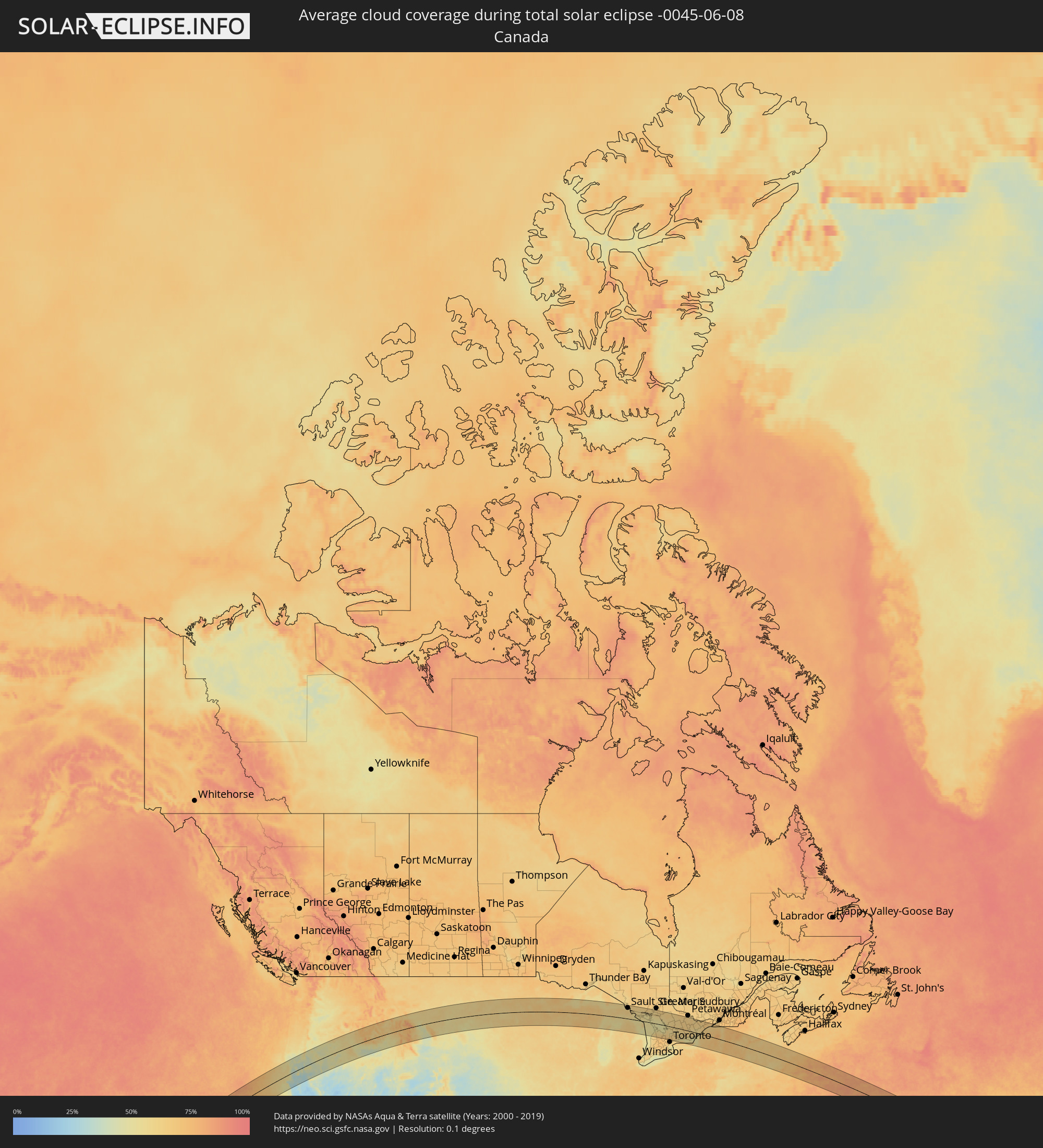 Canada
Cities inside the path of the eclipse
The following table shows all locations with a population of more than 5,000 inside the eclipse path. Cities which have more than 100,000 inhabitants are marked bold. A click at the locations opens a detailed map.
| City | Type | Eclipse duration | Local time of max. eclipse | Distance to central line | Ø Cloud coverage |
|
Waianae, Hawaii
|
total | - | 07:37:57 UTC-10:30 | 122 km | 66% |
|
Pearl City, Hawaii
|
total | - | 07:38:00 UTC-10:30 | 106 km | 64% |
|
Honolulu, Hawaii
|
total | - | 07:37:55 UTC-10:30 | 91 km | 52% |
|
Kailua, Hawaii
|
total | - | 07:38:07 UTC-10:30 | 92 km | 62% |
|
Lahaina, Hawaii
|
total | - | 07:37:54 UTC-10:30 | 20 km | 46% |
|
Kahului, Hawaii
|
total | - | 07:38:02 UTC-10:30 | 31 km | 62% |
|
Eureka, California
|
total | - | 11:18:14 UTC-08:00 | 3 km | 57% |
|
Fortuna, California
|
total | - | 11:17:59 UTC-08:00 | 24 km | 55% |
|
McKinleyville, California
|
total | - | 11:18:31 UTC-08:00 | 8 km | 56% |
|
Grants Pass, Oregon
|
total | - | 11:21:39 UTC-08:00 | 127 km | 42% |
|
Medford, Oregon
|
total | - | 11:22:18 UTC-08:00 | 99 km | 44% |
|
Ashland, Oregon
|
total | - | 11:22:26 UTC-08:00 | 80 km | 45% |
|
Redding, California
|
total | - | 11:21:07 UTC-08:00 | 93 km | 29% |
|
Anderson, California
|
total | - | 11:21:07 UTC-08:00 | 110 km | 29% |
|
Klamath Falls, Oregon
|
total | - | 11:24:05 UTC-08:00 | 49 km | 39% |
|
Ontario, Oregon
|
total | - | 12:34:22 UTC-07:00 | 78 km | 55% |
|
Caldwell, Idaho
|
total | - | 12:34:34 UTC-07:00 | 33 km | 53% |
|
Nampa, Idaho
|
total | - | 12:34:41 UTC-07:00 | 16 km | 53% |
|
Meridian, Idaho
|
total | - | 12:35:03 UTC-07:00 | 19 km | 54% |
|
Boise, Idaho
|
total | - | 12:35:23 UTC-07:00 | 14 km | 54% |
|
Mountain Home, Idaho
|
total | - | 12:35:56 UTC-07:00 | 51 km | 47% |
|
Jerome, Idaho
|
total | - | 12:37:47 UTC-07:00 | 126 km | 42% |
|
Idaho Falls, Idaho
|
total | - | 12:42:56 UTC-07:00 | 108 km | 51% |
|
Rexburg, Idaho
|
total | - | 12:43:36 UTC-07:00 | 75 km | 52% |
|
Bozeman, Montana
|
total | - | 12:45:55 UTC-07:00 | 107 km | 63% |
|
Cody, Wyoming
|
total | - | 12:48:56 UTC-07:00 | 56 km | 57% |
|
Billings, Montana
|
total | - | 12:50:24 UTC-07:00 | 70 km | 57% |
|
Sheridan, Wyoming
|
total | - | 12:52:49 UTC-07:00 | 63 km | 58% |
|
Dickinson, North Dakota
|
total | - | 13:00:17 UTC-07:00 | 113 km | 58% |
|
Bismarck, North Dakota
|
total | - | 14:03:34 UTC-06:00 | 88 km | 58% |
|
Jamestown, North Dakota
|
total | - | 14:06:52 UTC-06:00 | 87 km | 62% |
|
Aberdeen, South Dakota
|
total | - | 14:07:32 UTC-06:00 | 75 km | 61% |
|
Fargo, North Dakota
|
total | - | 14:09:53 UTC-06:00 | 76 km | 66% |
|
Fergus Falls, Minnesota
|
total | - | 14:11:12 UTC-06:00 | 9 km | 65% |
|
Alexandria, Minnesota
|
total | - | 14:12:26 UTC-06:00 | 36 km | 64% |
|
Willmar, Minnesota
|
total | - | 14:13:14 UTC-06:00 | 121 km | 65% |
|
Brainerd, Minnesota
|
total | - | 14:14:03 UTC-06:00 | 16 km | 65% |
|
Saint Cloud, Minnesota
|
total | - | 14:14:27 UTC-06:00 | 72 km | 66% |
|
Buffalo, Minnesota
|
total | - | 14:15:04 UTC-06:00 | 115 km | 63% |
|
Monticello, Minnesota
|
total | - | 14:15:08 UTC-06:00 | 100 km | 64% |
|
Elk River, Minnesota
|
total | - | 14:15:29 UTC-06:00 | 100 km | 62% |
|
Grand Rapids, Minnesota
|
total | - | 14:14:39 UTC-06:00 | 115 km | 64% |
|
West Coon Rapids, Minnesota
|
total | - | 14:15:53 UTC-06:00 | 116 km | 64% |
|
East Bethel, Minnesota
|
total | - | 14:16:03 UTC-06:00 | 98 km | 63% |
|
Lino Lakes, Minnesota
|
total | - | 14:16:18 UTC-06:00 | 115 km | 62% |
|
Forest Lake, Minnesota
|
total | - | 14:16:24 UTC-06:00 | 102 km | 61% |
|
North Branch, Minnesota
|
total | - | 14:16:18 UTC-06:00 | 76 km | 64% |
|
Cloquet, Minnesota
|
total | - | 14:16:28 UTC-06:00 | 60 km | 64% |
|
Duluth, Minnesota
|
total | - | 14:16:57 UTC-06:00 | 68 km | 65% |
|
Merrill, Wisconsin
|
total | - | 14:21:22 UTC-06:00 | 99 km | 68% |
|
Marinette, Wisconsin
|
total | - | 14:24:19 UTC-06:00 | 93 km | 56% |
|
Marquette, Michigan
|
total | - | 15:23:36 UTC-05:00 | 68 km | 61% |
|
Escanaba, Michigan
|
total | - | 15:24:37 UTC-05:00 | 17 km | 55% |
|
Traverse City, Michigan
|
total | - | 15:27:16 UTC-05:00 | 111 km | 58% |
|
Sault Ste. Marie, Michigan
|
total | - | 15:27:31 UTC-05:00 | 94 km | 61% |
|
Sault Ste. Marie, Ontario
|
total | - | 15:27:31 UTC-05:00 | 96 km | 61% |
|
Alpena, Michigan
|
total | - | 15:29:50 UTC-05:00 | 53 km | 56% |
|
Elliot Lake, Ontario
|
total | - | 15:29:40 UTC-05:00 | 103 km | 61% |
|
Hanover, Ontario
|
total | - | 15:33:31 UTC-05:00 | 118 km | 64% |
|
Owen Sound, Ontario
|
total | - | 15:33:15 UTC-05:00 | 71 km | 58% |
|
Collingwood, Ontario
|
total | - | 15:34:10 UTC-05:00 | 69 km | 59% |
|
Parry Sound, Ontario
|
total | - | 15:33:34 UTC-05:00 | 28 km | 53% |
|
Wasaga Beach, Ontario
|
total | - | 15:34:22 UTC-05:00 | 62 km | 58% |
|
Midland, Ontario
|
total | - | 15:34:18 UTC-05:00 | 34 km | 53% |
|
Angus, Ontario
|
total | - | 15:34:42 UTC-05:00 | 82 km | 65% |
|
Barrie, Ontario
|
total | - | 15:34:52 UTC-05:00 | 69 km | 64% |
|
Innisfil, Ontario
|
total | - | 15:34:59 UTC-05:00 | 80 km | 61% |
|
Keswick, Ontario
|
total | - | 15:35:14 UTC-05:00 | 82 km | 59% |
|
Newmarket, Ontario
|
total | - | 15:35:25 UTC-05:00 | 104 km | 68% |
|
Orillia, Ontario
|
total | - | 15:34:56 UTC-05:00 | 42 km | 57% |
|
Gravenhurst, Ontario
|
total | - | 15:34:43 UTC-05:00 | 8 km | 58% |
|
Bracebridge, Ontario
|
total | - | 15:34:39 UTC-05:00 | 6 km | 59% |
|
Markham, Ontario
|
total | - | 15:35:49 UTC-05:00 | 120 km | 67% |
|
Huntsville, Ontario
|
total | - | 15:34:29 UTC-05:00 | 40 km | 61% |
|
Pickering, Ontario
|
total | - | 15:35:56 UTC-05:00 | 114 km | 63% |
|
Uxbridge, Ontario
|
total | - | 15:35:46 UTC-05:00 | 92 km | 65% |
|
Ajax, Ontario
|
total | - | 15:36:05 UTC-05:00 | 118 km | 62% |
|
Oshawa, Ontario
|
total | - | 15:36:15 UTC-05:00 | 109 km | 58% |
|
Peterborough, Ontario
|
total | - | 15:36:26 UTC-05:00 | 56 km | 58% |
|
Cobourg, Ontario
|
total | - | 15:36:56 UTC-05:00 | 90 km | 53% |
|
Quinte West, Ontario
|
total | - | 15:37:21 UTC-05:00 | 55 km | 59% |
|
Belleville, Ontario
|
total | - | 15:37:33 UTC-05:00 | 53 km | 59% |
|
Prince Edward, Ontario
|
total | - | 15:37:52 UTC-05:00 | 69 km | 53% |
|
Greater Napanee, Ontario
|
total | - | 15:37:55 UTC-05:00 | 36 km | 63% |
|
Renfrew, Ontario
|
total | - | 15:36:58 UTC-05:00 | 100 km | 62% |
|
Oswego, New York
|
total | - | 15:39:10 UTC-05:00 | 113 km | 51% |
|
Kingston, Ontario
|
total | - | 15:38:25 UTC-05:00 | 29 km | 51% |
|
Arnprior, Ontario
|
total | - | 15:37:20 UTC-05:00 | 103 km | 64% |
|
Perth, Ontario
|
total | - | 15:37:58 UTC-05:00 | 48 km | 59% |
|
Gananoque, Ontario
|
total | - | 15:38:38 UTC-05:00 | 12 km | 53% |
|
Carleton Place, Ontario
|
total | - | 15:37:50 UTC-05:00 | 75 km | 62% |
|
Smiths Falls, Ontario
|
total | - | 15:38:11 UTC-05:00 | 53 km | 59% |
|
Watertown, New York
|
total | - | 15:39:15 UTC-05:00 | 45 km | 63% |
|
Bells Corners, Ontario
|
total | - | 15:37:57 UTC-05:00 | 101 km | 66% |
|
le Plateau, Quebec
|
total | - | 15:37:53 UTC-05:00 | 115 km | 63% |
|
Fort Drum, New York
|
total | - | 15:39:18 UTC-05:00 | 33 km | 66% |
|
Ottawa, Ontario
|
total | - | 15:37:59 UTC-05:00 | 114 km | 65% |
|
Brockville, Ontario
|
total | - | 15:38:50 UTC-05:00 | 26 km | 59% |
|
Ogdensburg, New York
|
total | - | 15:38:55 UTC-05:00 | 41 km | 63% |
|
Rome, New York
|
total | - | 15:40:28 UTC-05:00 | 118 km | 63% |
|
Potsdam, New York
|
total | - | 15:39:26 UTC-05:00 | 49 km | 63% |
|
Massena, New York
|
total | - | 15:39:15 UTC-05:00 | 78 km | 60% |
|
Cornwall, Ontario
|
total | - | 15:39:18 UTC-05:00 | 92 km | 62% |
|
Gloversville, New York
|
total | - | 15:41:42 UTC-05:00 | 111 km | 68% |
|
Saratoga Springs, New York
|
total | - | 15:42:12 UTC-05:00 | 95 km | 66% |
|
Glens Falls, New York
|
total | - | 15:42:06 UTC-05:00 | 68 km | 64% |
|
Plattsburgh, New York
|
total | - | 15:40:48 UTC-05:00 | 85 km | 64% |
|
Burlington, Vermont
|
total | - | 15:41:15 UTC-05:00 | 67 km | 65% |
|
Rutland, Vermont
|
total | - | 15:42:23 UTC-05:00 | 20 km | 72% |
|
Claremont, New Hampshire
|
total | - | 15:43:11 UTC-05:00 | 31 km | 73% |
|
Keene, New Hampshire
|
total | - | 15:43:43 UTC-05:00 | 76 km | 69% |
|
Lebanon, New Hampshire
|
total | - | 15:42:59 UTC-05:00 | 0 km | 69% |
|
Gardner, Massachusetts
|
total | - | 15:44:20 UTC-05:00 | 108 km | 67% |
|
Leominster, Massachusetts
|
total | - | 15:44:36 UTC-05:00 | 107 km | 66% |
|
Hudson, Massachusetts
|
total | - | 15:44:54 UTC-05:00 | 117 km | 67% |
|
Concord, New Hampshire
|
total | - | 15:44:03 UTC-05:00 | 29 km | 67% |
|
Laconia, New Hampshire
|
total | - | 15:43:46 UTC-05:00 | 6 km | 65% |
|
Nashua, New Hampshire
|
total | - | 15:44:35 UTC-05:00 | 75 km | 69% |
|
Manchester, New Hampshire
|
total | - | 15:44:21 UTC-05:00 | 50 km | 71% |
|
Acton, Massachusetts
|
total | - | 15:44:55 UTC-05:00 | 104 km | 67% |
|
Lowell, Massachusetts
|
total | - | 15:44:51 UTC-05:00 | 85 km | 70% |
|
Derry Village, New Hampshire
|
total | - | 15:44:35 UTC-05:00 | 57 km | 70% |
|
Weston, Massachusetts
|
total | - | 15:45:09 UTC-05:00 | 113 km | 68% |
|
Berlin, New Hampshire
|
total | - | 15:42:59 UTC-05:00 | 113 km | 72% |
|
Woburn, Massachusetts
|
total | - | 15:45:10 UTC-05:00 | 97 km | 70% |
|
Haverhill, Massachusetts
|
total | - | 15:44:54 UTC-05:00 | 64 km | 67% |
|
Boston, Massachusetts
|
total | - | 15:45:22 UTC-05:00 | 108 km | 71% |
|
Middleton, Massachusetts
|
total | - | 15:45:09 UTC-05:00 | 82 km | 68% |
|
Lynn, Massachusetts
|
total | - | 15:45:20 UTC-05:00 | 94 km | 70% |
|
Amesbury, Massachusetts
|
total | - | 15:44:56 UTC-05:00 | 52 km | 66% |
|
Dover, New Hampshire
|
total | - | 15:44:37 UTC-05:00 | 14 km | 65% |
|
Sanford, Maine
|
total | - | 15:44:26 UTC-05:00 | 14 km | 66% |
|
Portsmouth, New Hampshire
|
total | - | 15:44:51 UTC-05:00 | 25 km | 65% |
|
Gloucester, Massachusetts
|
total | - | 15:45:25 UTC-05:00 | 71 km | 67% |
|
York Beach, Maine
|
total | - | 15:44:52 UTC-05:00 | 10 km | 68% |
|
Wells Beach Station, Maine
|
total | - | 15:44:42 UTC-05:00 | 6 km | 68% |
|
Biddeford, Maine
|
total | - | 15:44:38 UTC-05:00 | 28 km | 64% |
|
Portland, Maine
|
total | - | 15:44:36 UTC-05:00 | 50 km | 66% |
|
Lewiston, Maine
|
total | - | 15:44:09 UTC-05:00 | 98 km | 66% |
|
Brunswick, Maine
|
total | - | 15:44:33 UTC-05:00 | 84 km | 69% |