Total solar eclipse of 07/28/-0131
| Day of week: | Monday |
| Maximum duration of eclipse: | 04m14s |
| Maximum width of eclipse path: | 398 km |
| Saros cycle: | 82 |
| Coverage: | 100% |
| Magnitude: | 1.0539 |
| Gamma: | -0.8959 |
Wo kann man die Sonnenfinsternis vom 07/28/-0131 sehen?
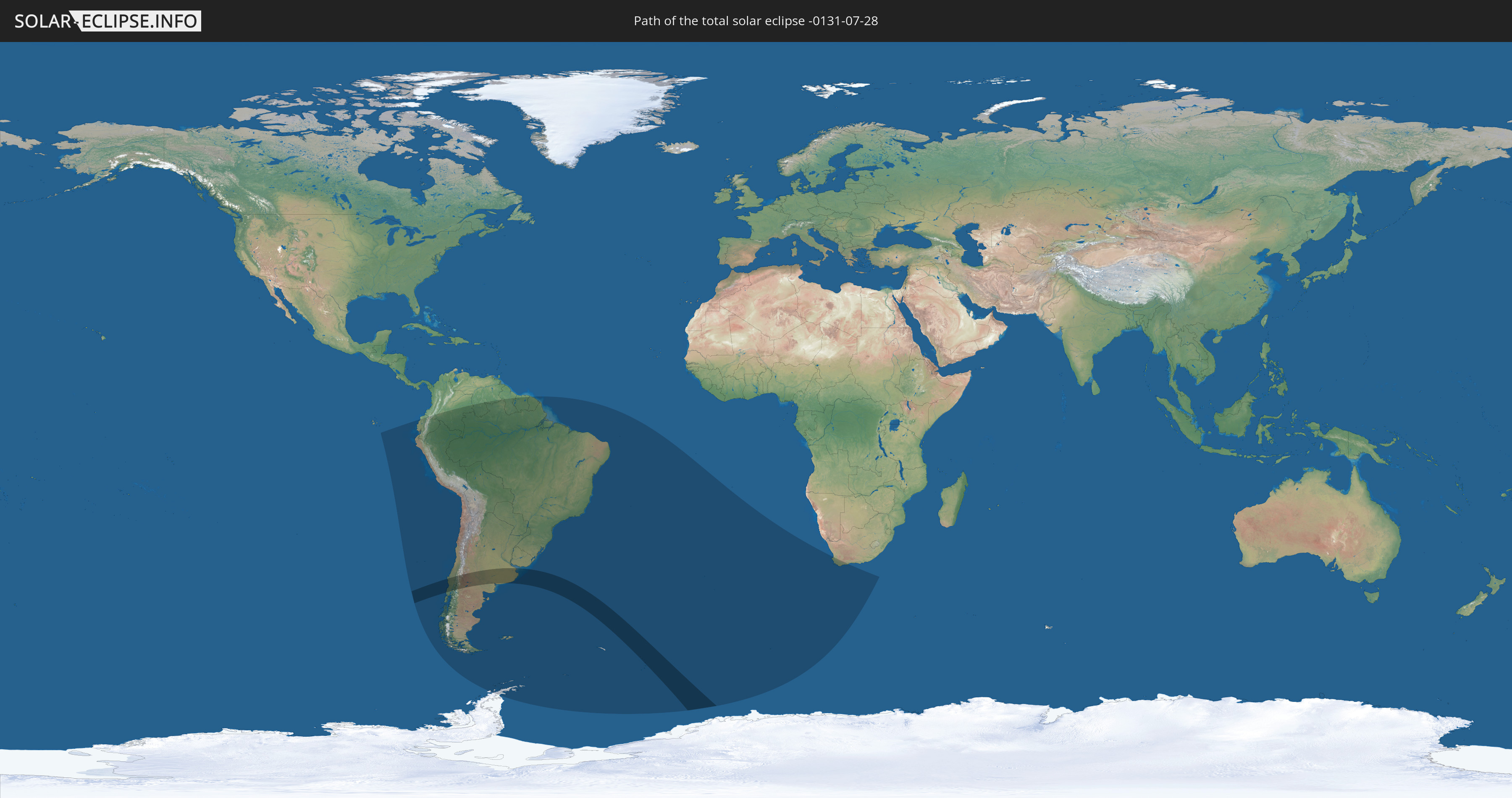
Die Sonnenfinsternis am 07/28/-0131 kann man in 19 Ländern als partielle Sonnenfinsternis beobachten.
Der Finsternispfad verläuft durch 3 Länder. Nur in diesen Ländern ist sie als total Sonnenfinsternis zu sehen.
In den folgenden Ländern ist die Sonnenfinsternis total zu sehen
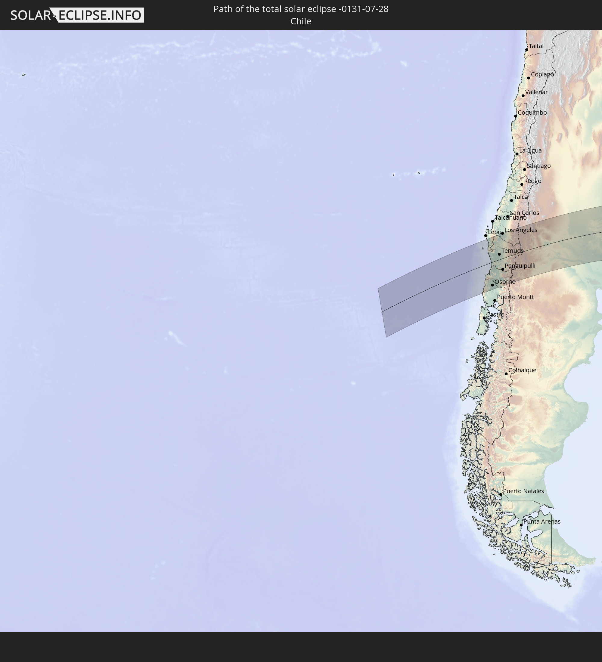 Chile
Chile
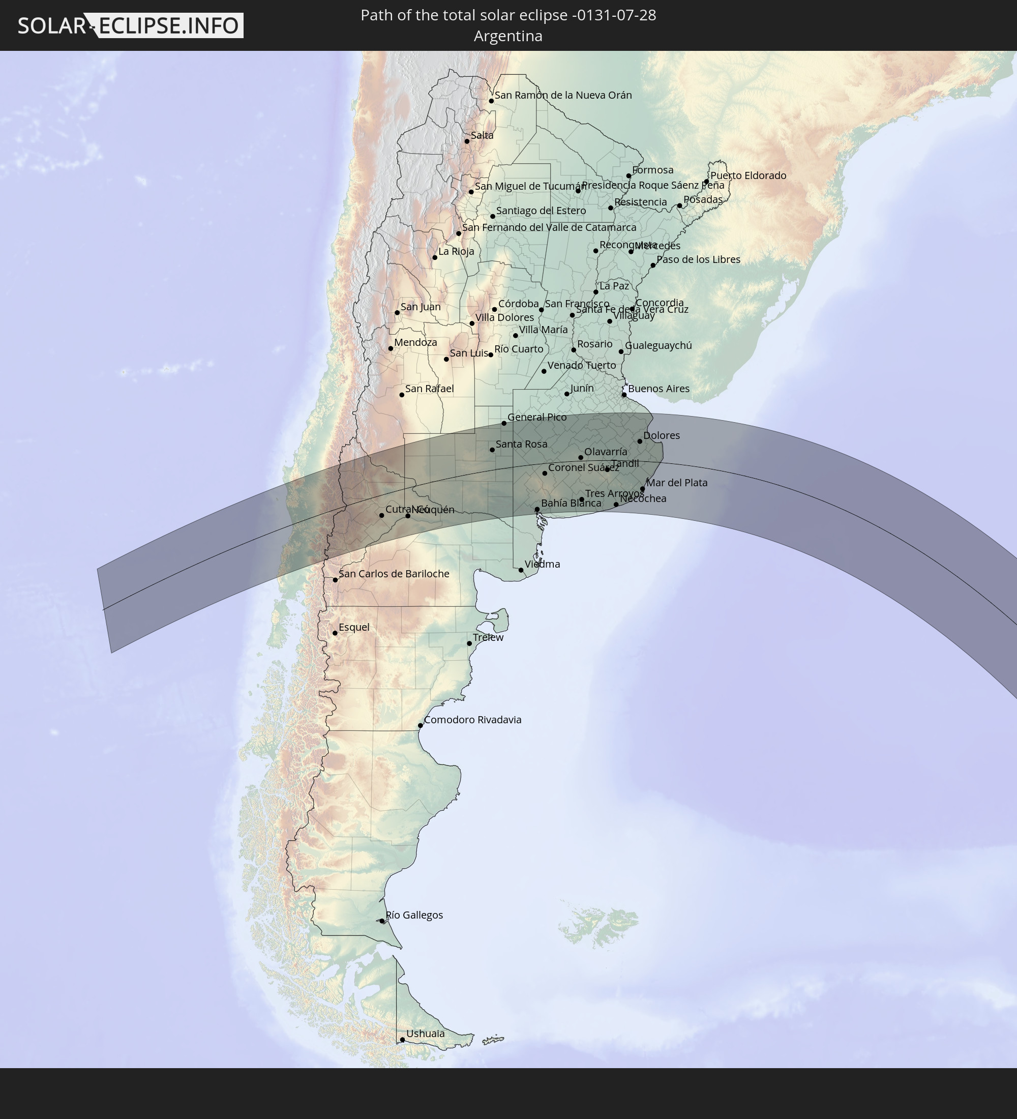 Argentina
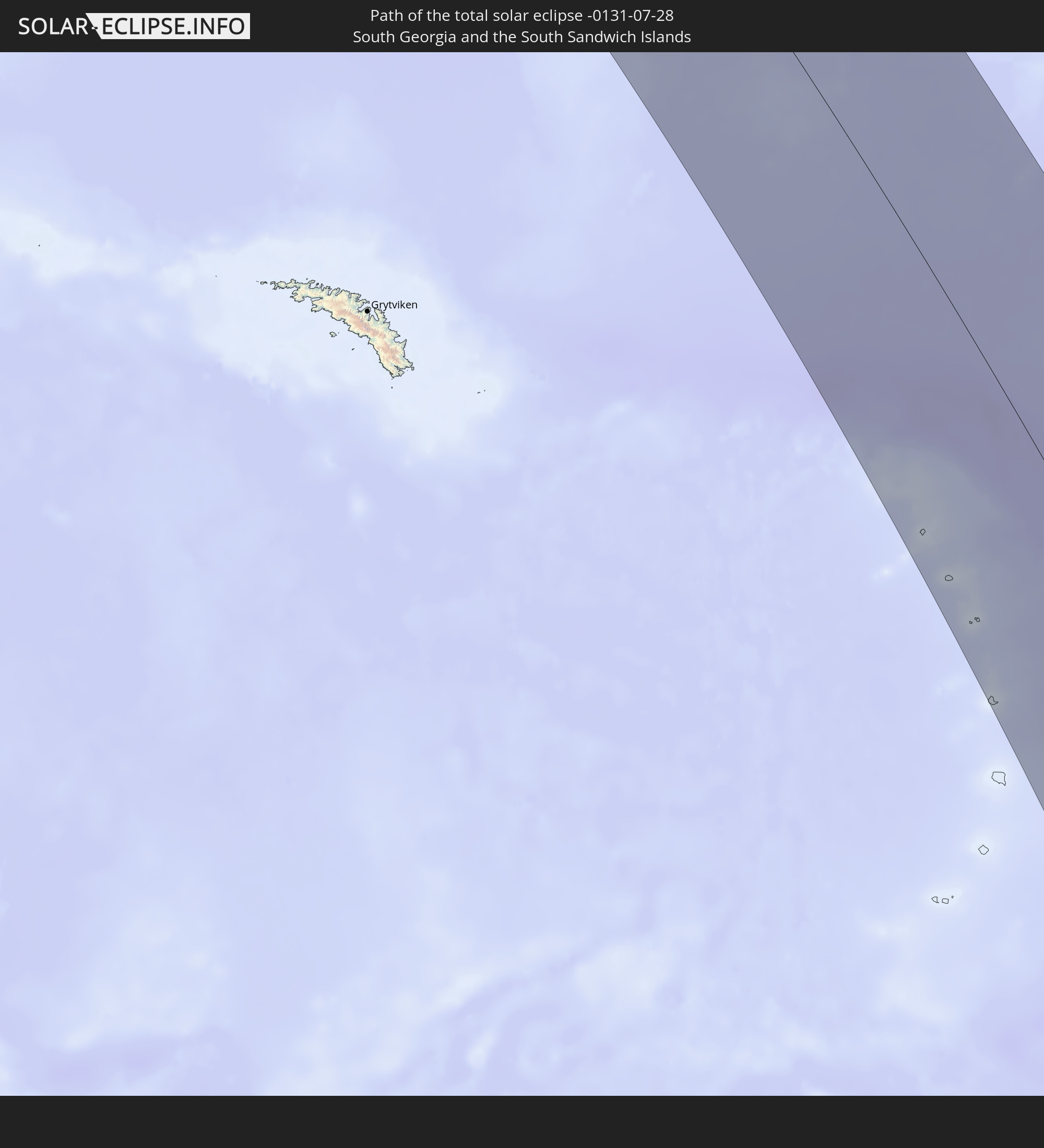 South Georgia and the South Sandwich Islands
In den folgenden Ländern ist die Sonnenfinsternis partiell zu sehen


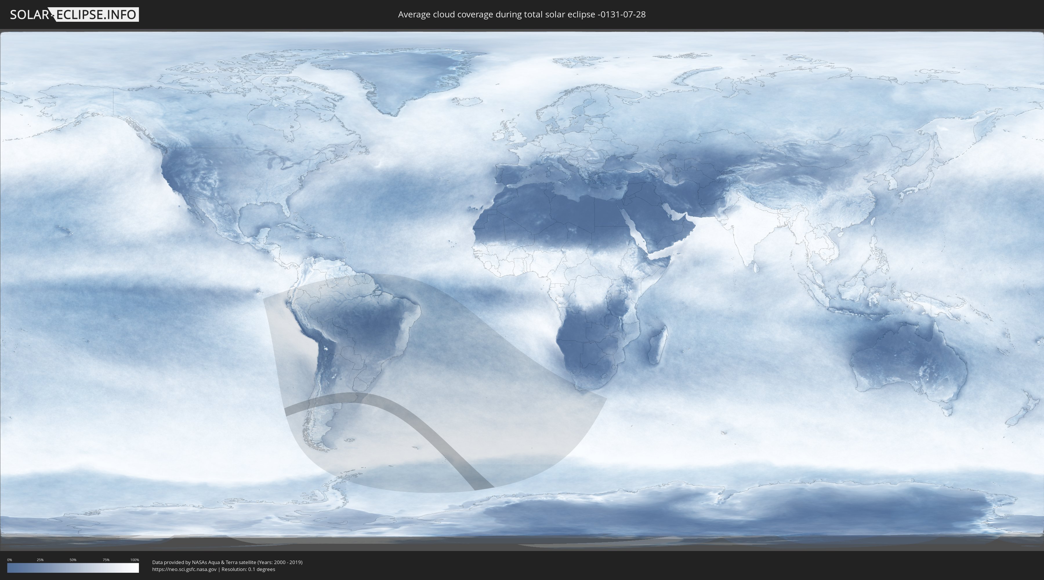
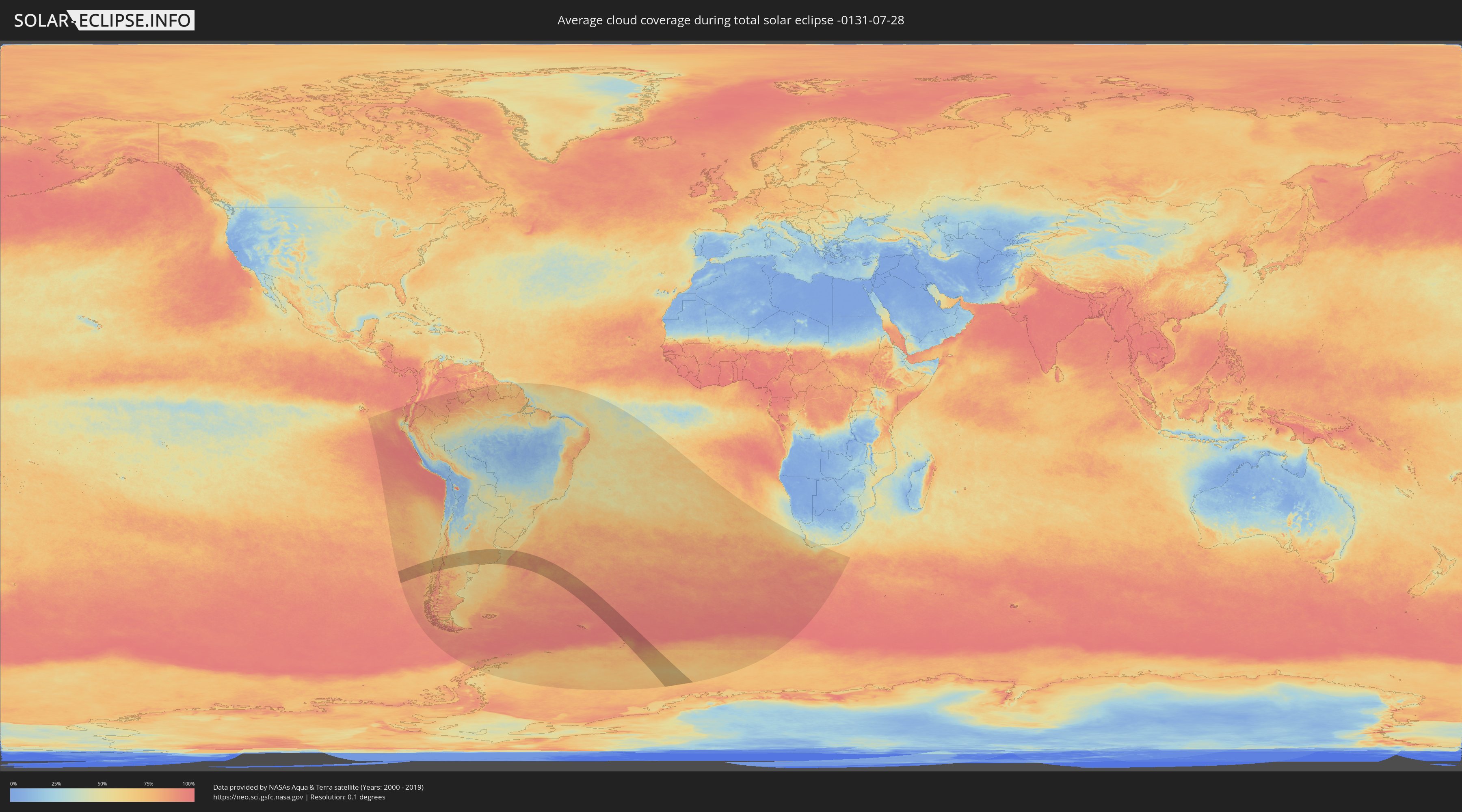
How will be the weather during the total solar eclipse on 07/28/-0131?
Where is the best place to see the total solar eclipse of 07/28/-0131?
The following maps show the average cloud coverage for the day of the total solar eclipse.
With the help of these maps, it is possible to find the place along the eclipse path, which has the best
chance of a cloudless sky.
Nevertheless, you should consider local circumstances and inform about the weather of your chosen
observation site.
The data is provided by NASAs satellites
AQUA and TERRA.
The cloud maps are averaged over a period of 19 years (2000 - 2019).
Detailed country maps
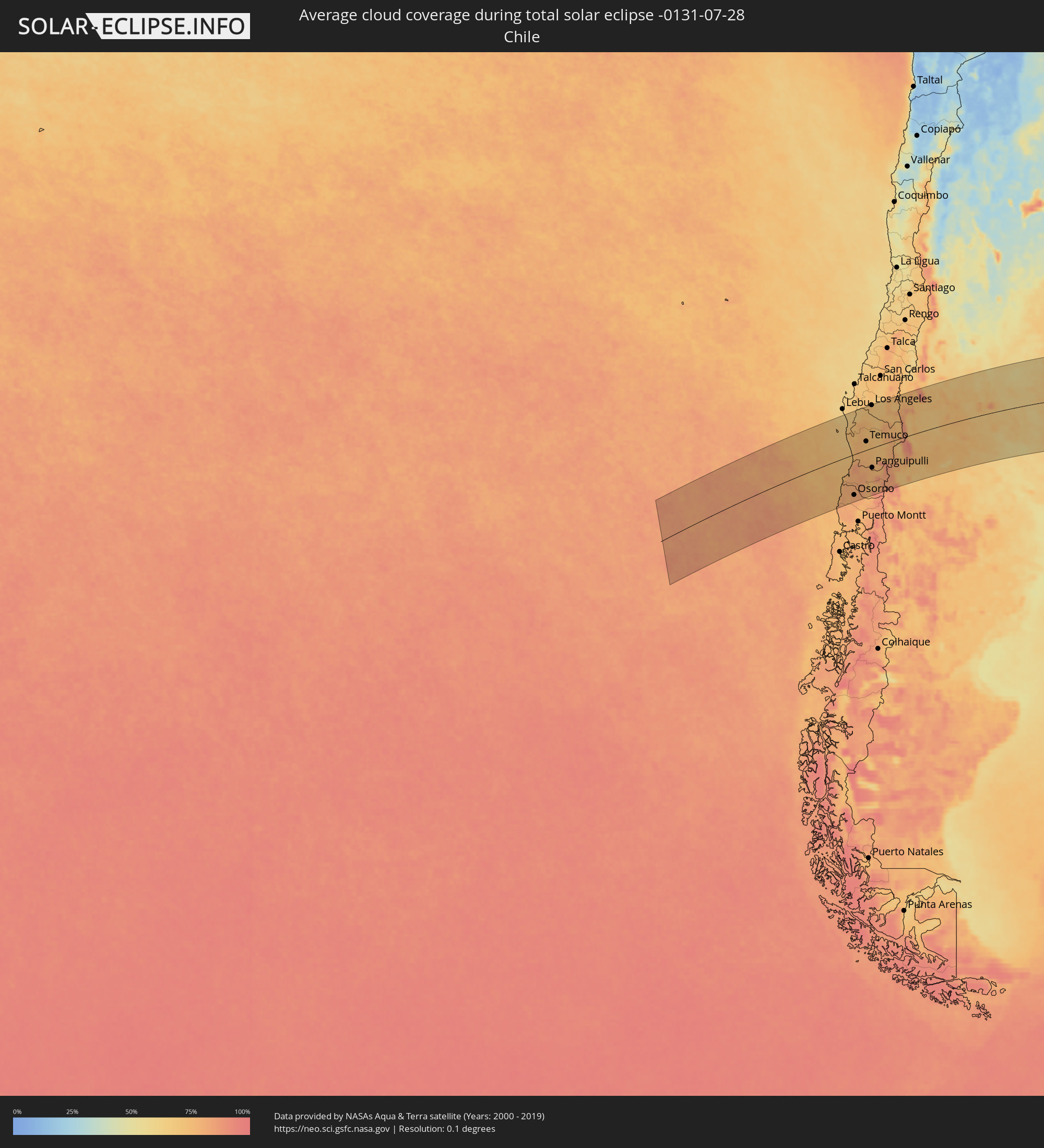 Chile
Chile
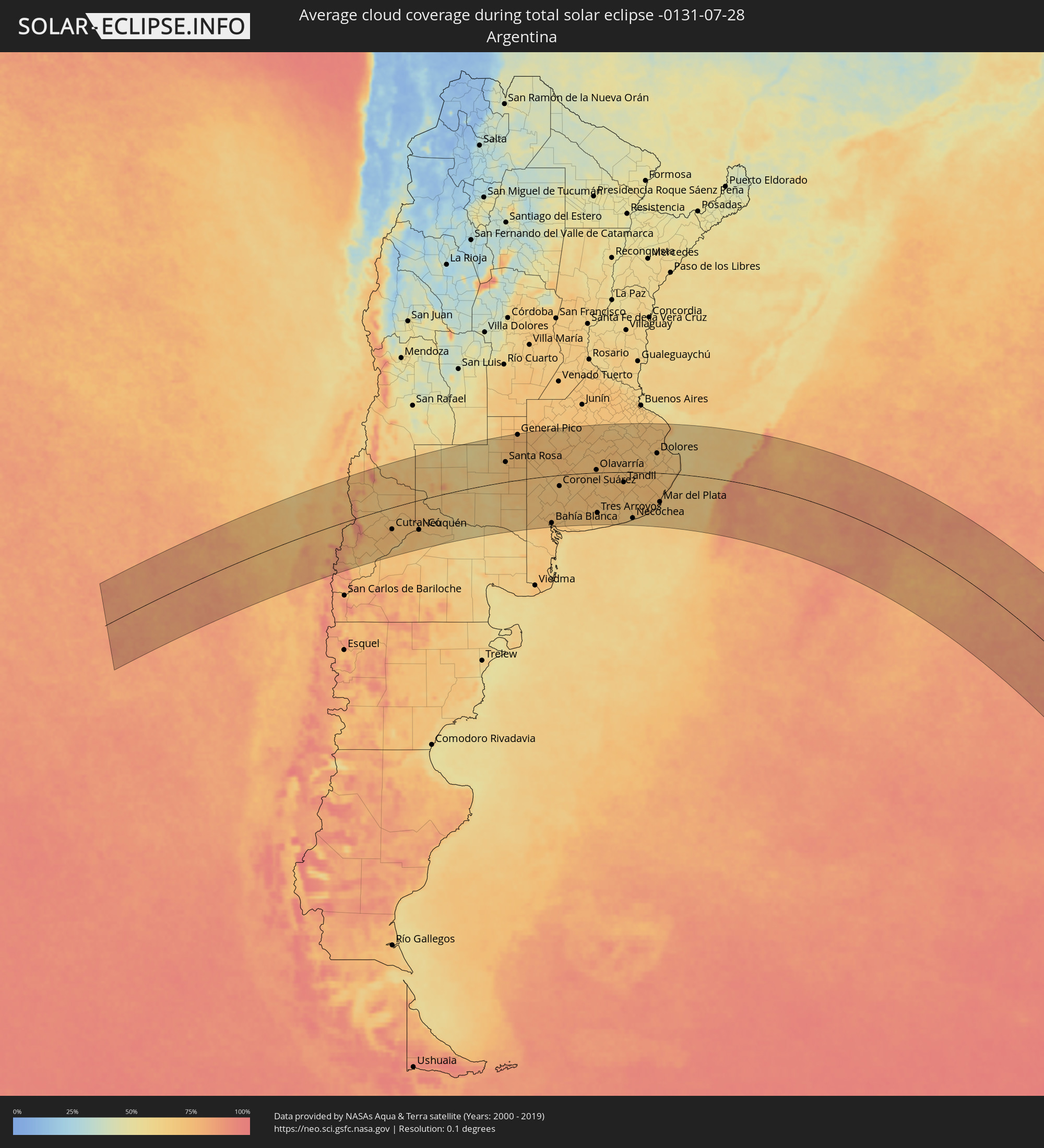 Argentina
 South Georgia and the South Sandwich Islands
Cities inside the path of the eclipse
The following table shows all locations with a population of more than 5,000 inside the eclipse path. Cities which have more than 100,000 inhabitants are marked bold. A click at the locations opens a detailed map.
| City | Type | Eclipse duration | Local time of max. eclipse | Distance to central line | Ø Cloud coverage |
 Cañete, Biobío
|
total | - | 08:04:08 UTC-04:42 | 153 km | 65% |
|
Valdivia, Los Ríos
|
total | - | 08:07:24 UTC-04:42 | 62 km | 81% |
|
Las Animas, Los Lagos
|
total | - | 08:07:25 UTC-04:42 | 62 km | 81% |
|
Carahue, Araucanía
|
total | - | 08:05:45 UTC-04:42 | 51 km | 72% |
|
Osorno, Los Lagos
|
total | - | 08:08:42 UTC-04:42 | 144 km | 81% |
|
La Unión, Los Ríos
|
total | - | 08:08:18 UTC-04:42 | 117 km | 80% |
|
Río Bueno, Los Ríos
|
total | - | 08:08:29 UTC-04:42 | 125 km | 81% |
|
Nueva Imperial, Araucanía
|
total | - | 08:06:00 UTC-04:42 | 41 km | 77% |
|
Angol, Araucanía
|
total | - | 08:04:45 UTC-04:42 | 134 km | 72% |
|
Traiguén, Araucanía
|
total | - | 08:05:30 UTC-04:42 | 85 km | 76% |
|
Pitrufquén, Araucanía
|
total | - | 08:06:40 UTC-04:42 | 7 km | 74% |
|
Loncoche, Araucanía
|
total | - | 08:07:16 UTC-04:42 | 33 km | 77% |
|
Freire, Araucanía
|
total | - | 08:06:38 UTC-04:42 | 10 km | 74% |
|
Temuco, Araucanía
|
total | - | 08:06:20 UTC-04:42 | 31 km | 74% |
|
Lautaro, Araucanía
|
total | - | 08:06:10 UTC-04:42 | 49 km | 73% |
|
Collipulli, Araucanía
|
total | - | 08:05:16 UTC-04:42 | 109 km | 73% |
|
Los Ángeles, Biobío
|
total | - | 08:04:36 UTC-04:42 | 158 km | 73% |
|
Victoria, Araucanía
|
total | - | 08:05:48 UTC-04:42 | 77 km | 73% |
|
Panguipulli, Araucanía
|
total | - | 08:08:00 UTC-04:42 | 71 km | 75% |
|
Mulchén, Biobío
|
total | - | 08:05:06 UTC-04:42 | 129 km | 68% |
|
Villarrica, Araucanía
|
total | - | 08:07:32 UTC-04:42 | 37 km | 74% |
|
Vilcún, Araucanía
|
total | - | 08:06:35 UTC-04:42 | 28 km | 71% |
|
Pucón, Araucanía
|
total | - | 08:07:48 UTC-04:42 | 44 km | 80% |
 San Martín de los Andes, Neuquén Province
|
total | - | 08:35:44 UTC-04:16 | 153 km | 87% |
|
Junín de los Andes, Neuquén Province
|
total | - | 08:35:42 UTC-04:16 | 139 km | 70% |
|
Chos Malal, Neuquén Province
|
total | - | 08:32:32 UTC-04:16 | 112 km | 72% |
|
Zapala, Neuquén Province
|
total | - | 08:35:06 UTC-04:16 | 55 km | 73% |
|
Cutral-Có, Neuquén Province
|
total | - | 08:36:03 UTC-04:16 | 80 km | 72% |
|
Plaza Huincul, Neuquén Province
|
total | - | 08:36:03 UTC-04:16 | 79 km | 72% |
|
Senillosa, Neuquén Province
|
total | - | 08:37:03 UTC-04:16 | 107 km | 72% |
|
Plottier, Neuquén Province
|
total | - | 08:37:12 UTC-04:16 | 107 km | 74% |
|
Centenario, Neuquén Province
|
total | - | 08:37:07 UTC-04:16 | 94 km | 71% |
|
Cinco Saltos, Río Negro Province
|
total | - | 08:37:11 UTC-04:16 | 95 km | 71% |
|
Neuquén, Neuquén Province
|
total | - | 08:37:23 UTC-04:16 | 109 km | 74% |
|
Cipolletti, Río Negro Province
|
total | - | 08:37:26 UTC-04:16 | 108 km | 70% |
|
General Fernández Oro, Río Negro Province
|
total | - | 08:37:32 UTC-04:16 | 112 km | 66% |
|
Allen, Río Negro Province
|
total | - | 08:37:41 UTC-04:16 | 117 km | 66% |
|
Catriel, Río Negro Province
|
total | - | 08:36:02 UTC-04:16 | 1 km | 67% |
|
Veinticinco de Mayo, La Pampa Province
|
total | - | 08:35:58 UTC-04:16 | 11 km | 66% |
|
General Roca, Río Negro Province
|
total | - | 08:38:03 UTC-04:16 | 128 km | 68% |
|
Cervantes, Río Negro Province
|
total | - | 08:38:19 UTC-04:16 | 134 km | 64% |
|
Ingeniero Luis A. Huergo, Río Negro Province
|
total | - | 08:38:32 UTC-04:16 | 141 km | 64% |
|
Villa Regina, Río Negro Province
|
total | - | 08:38:46 UTC-04:16 | 146 km | 65% |
|
Victorica, La Pampa Province
|
total | - | 08:36:22 UTC-04:16 | 138 km | 59% |
|
General Acha, La Pampa Province
|
total | - | 08:39:10 UTC-04:16 | 2 km | 64% |
|
Eduardo Castex, La Pampa Province
|
total | - | 08:37:22 UTC-04:16 | 154 km | 72% |
|
Santa Rosa, La Pampa Province
|
total | - | 08:38:26 UTC-04:16 | 76 km | 70% |
|
General Pico, La Pampa Province
|
total | - | 08:37:42 UTC-04:16 | 175 km | 76% |
|
Guatraché, La Pampa Province
|
total | - | 08:41:01 UTC-04:16 | 49 km | 71% |
|
Bahía Blanca, Buenos Aires
|
total | - | 08:44:18 UTC-04:16 | 179 km | 71% |
|
Coronel Suárez, Buenos Aires
|
total | - | 08:42:52 UTC-04:16 | 42 km | 67% |
|
Coronel Dorrego, Buenos Aires
|
total | - | 08:45:40 UTC-04:16 | 187 km | 68% |
|
Nueve de Julio, Buenos Aires
|
total | - | 08:41:24 UTC-04:16 | 174 km | 73% |
|
Olavarría, Buenos Aires
|
total | - | 08:44:20 UTC-04:16 | 11 km | 72% |
|
Tres Arroyos, Buenos Aires
|
total | - | 08:46:35 UTC-04:16 | 154 km | 69% |
|
Veinticinco de Mayo, Buenos Aires
|
total | - | 08:42:25 UTC-04:16 | 173 km | 70% |
|
Azul, Buenos Aires
|
total | - | 08:44:51 UTC-04:16 | 22 km | 73% |
|
Tandil, Buenos Aires
|
total | - | 08:46:44 UTC-04:16 | 39 km | 72% |
|
Necochea, Buenos Aires
|
total | - | 08:49:08 UTC-04:16 | 176 km | 60% |
|
Dolores, Buenos Aires
|
total | - | 08:47:31 UTC-04:16 | 76 km | 68% |
|
Mar del Plata, Buenos Aires
|
total | - | 08:50:08 UTC-04:16 | 111 km | 70% |
|
Villa Gesell, Buenos Aires
|
total | - | 08:50:00 UTC-04:16 | 26 km | 66% |
|
San Clemente del Tuyú, Buenos Aires
|
total | - | 08:49:06 UTC-04:16 | 77 km | 66% |