Total solar eclipse of 03/15/-0143
| Day of week: | Friday |
| Maximum duration of eclipse: | 05m45s |
| Maximum width of eclipse path: | 216 km |
| Saros cycle: | 66 |
| Coverage: | 100% |
| Magnitude: | 1.065 |
| Gamma: | -0.172 |
Wo kann man die Sonnenfinsternis vom 03/15/-0143 sehen?
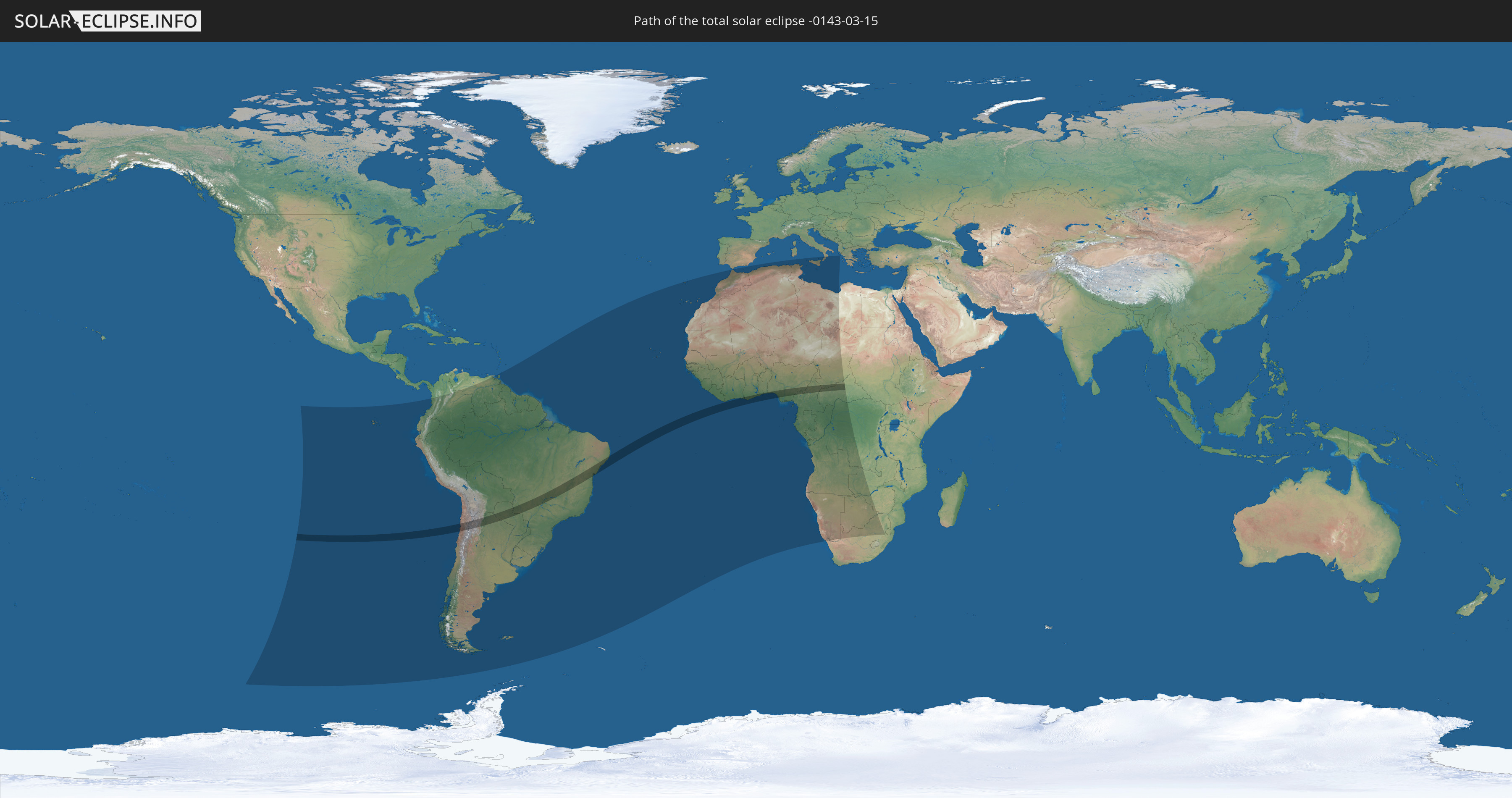
Die Sonnenfinsternis am 03/15/-0143 kann man in 54 Ländern als partielle Sonnenfinsternis beobachten.
Der Finsternispfad verläuft durch 12 Länder. Nur in diesen Ländern ist sie als total Sonnenfinsternis zu sehen.
In den folgenden Ländern ist die Sonnenfinsternis total zu sehen
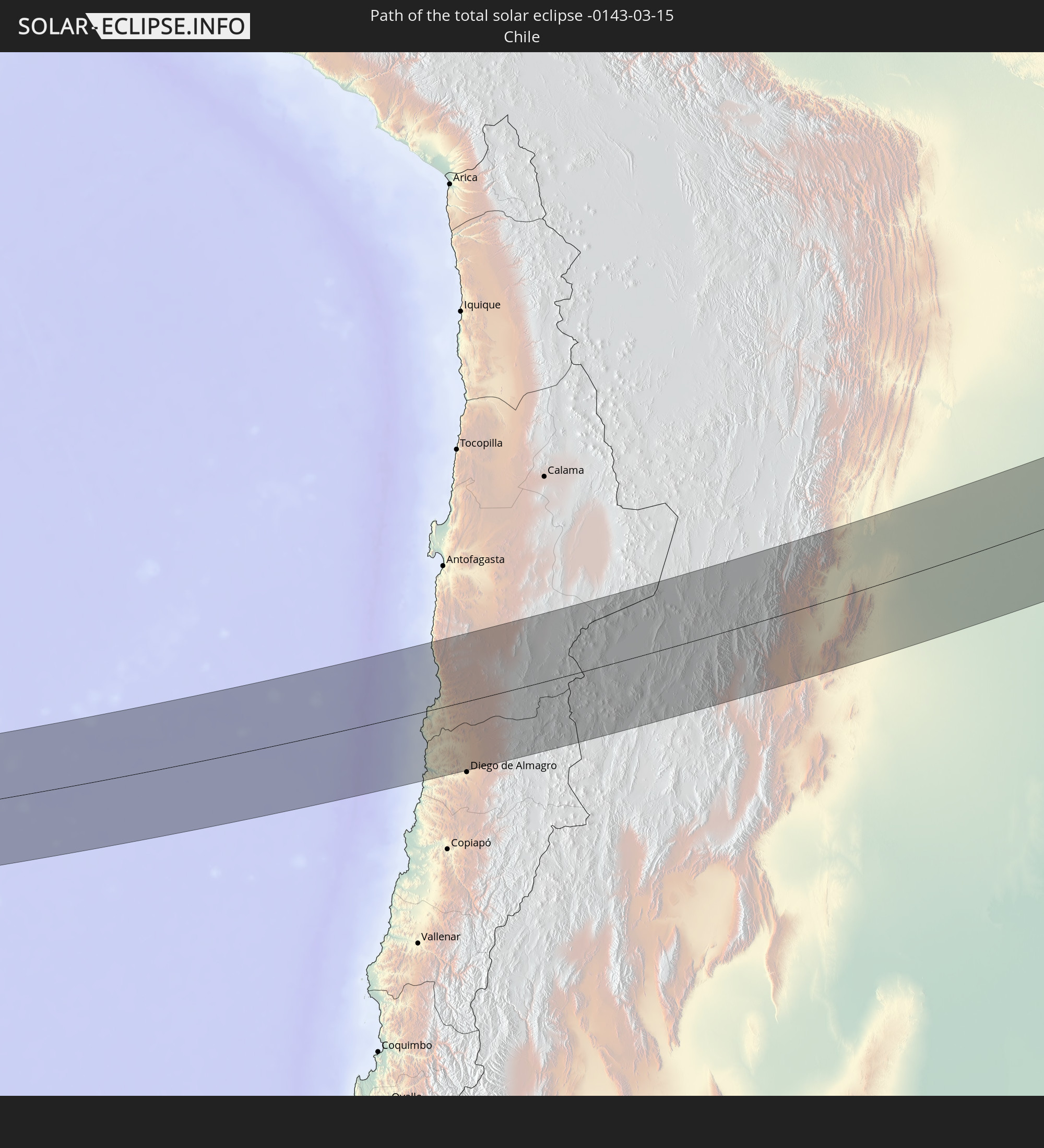 Chile
Chile
 Brazil
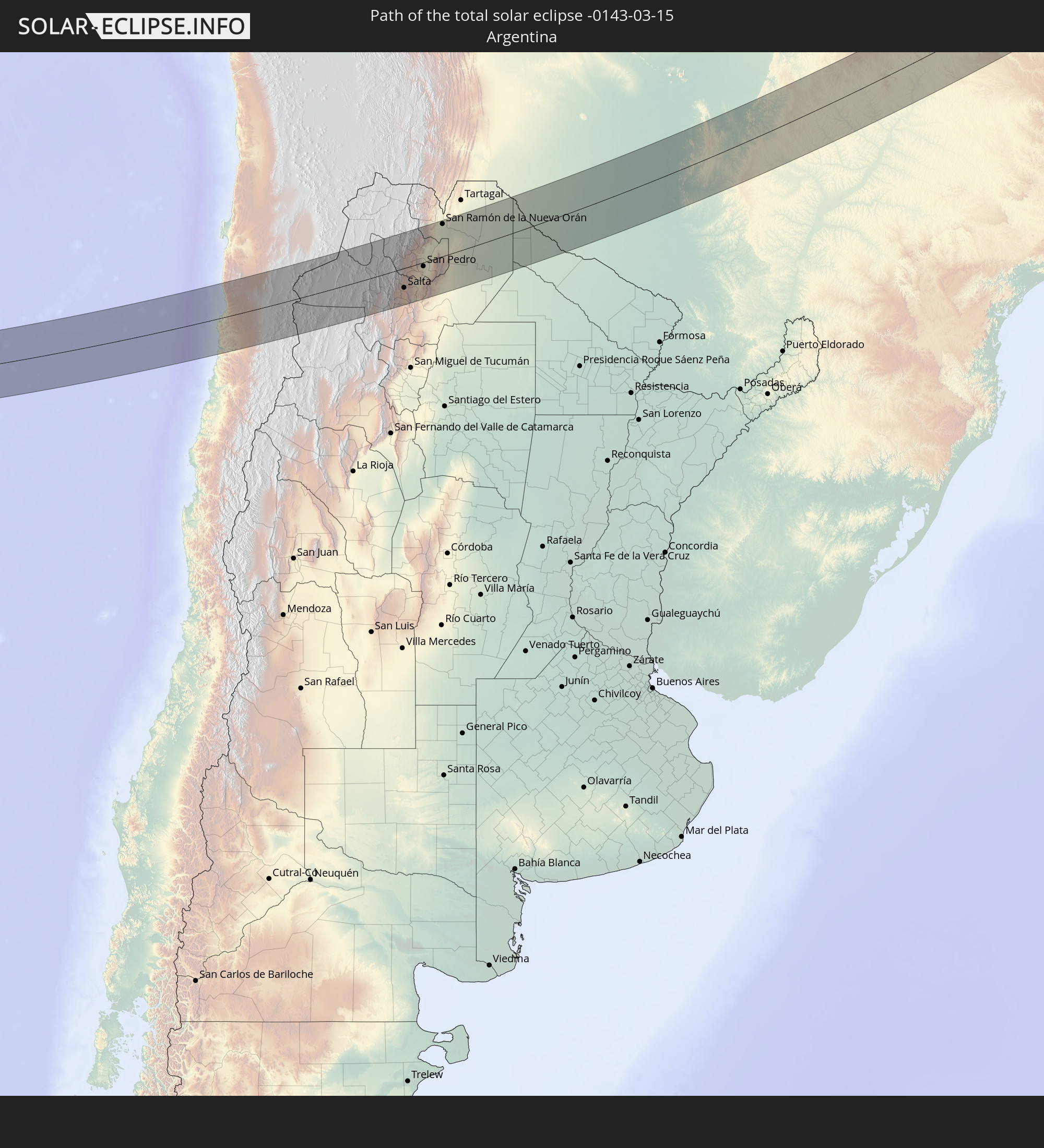 Argentina
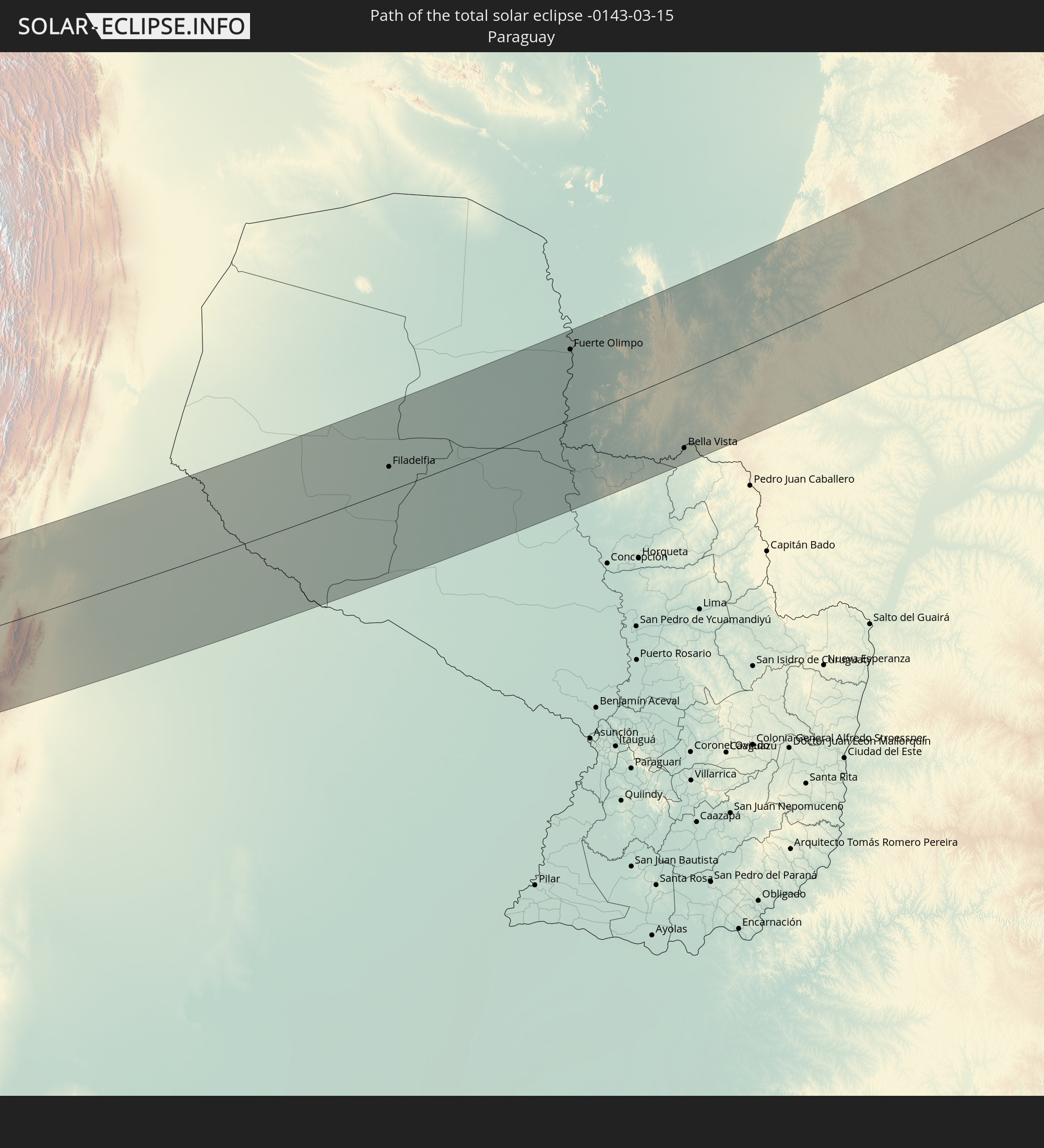 Paraguay
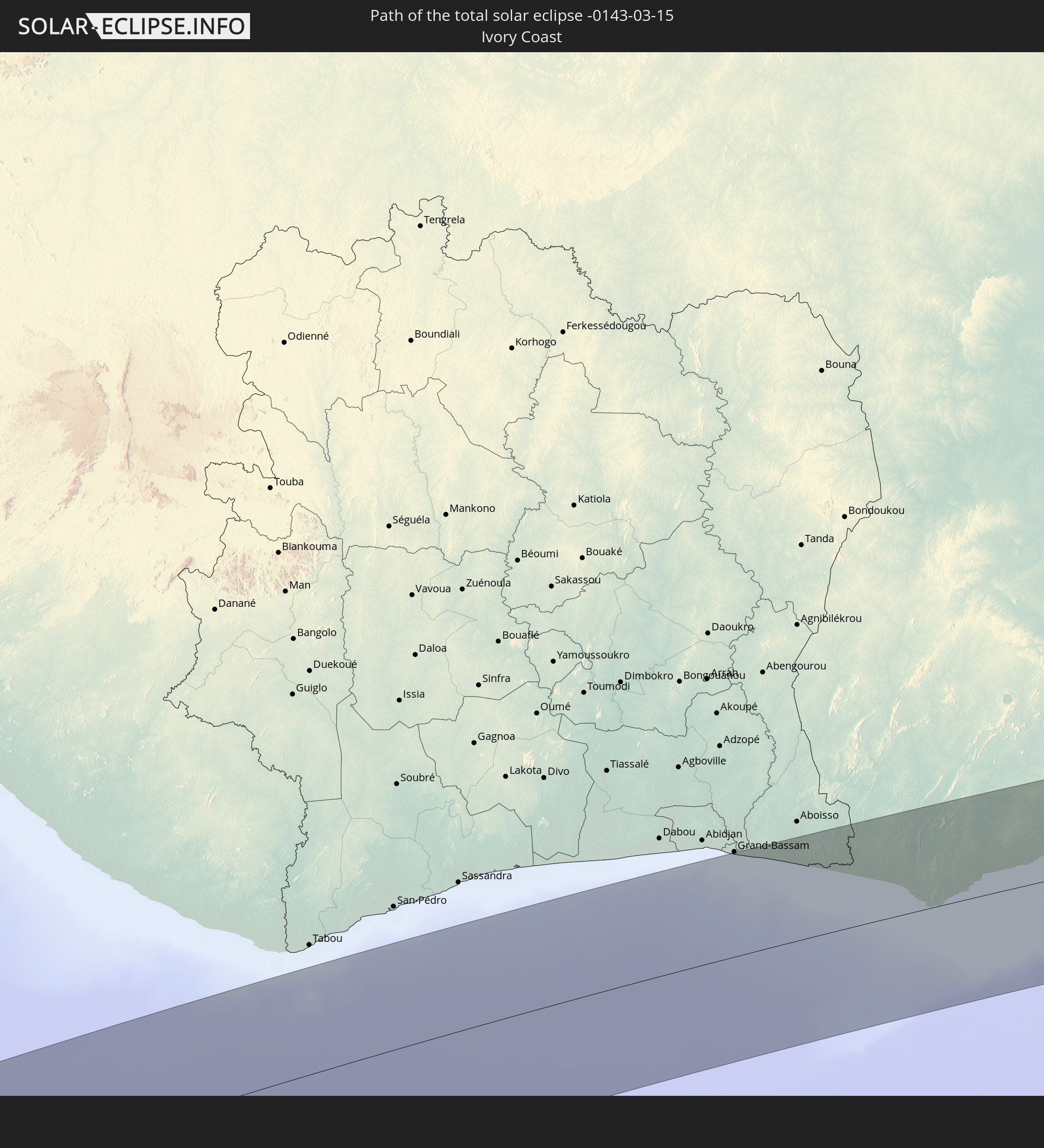 Ivory Coast
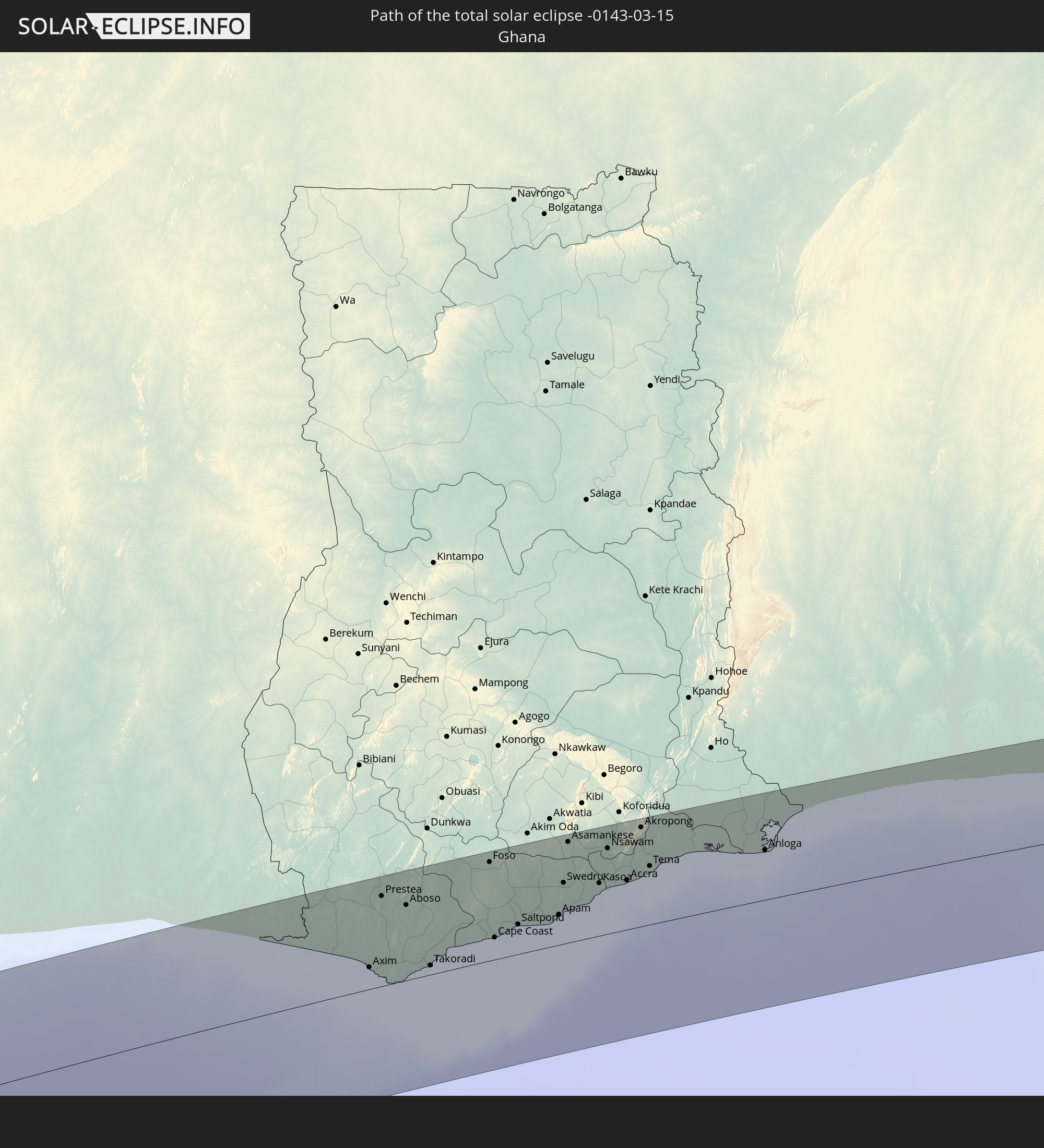 Ghana
Ghana
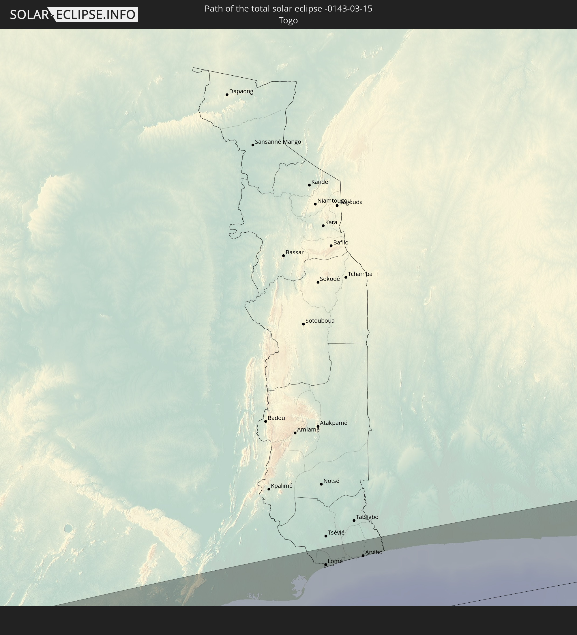 Togo
Togo
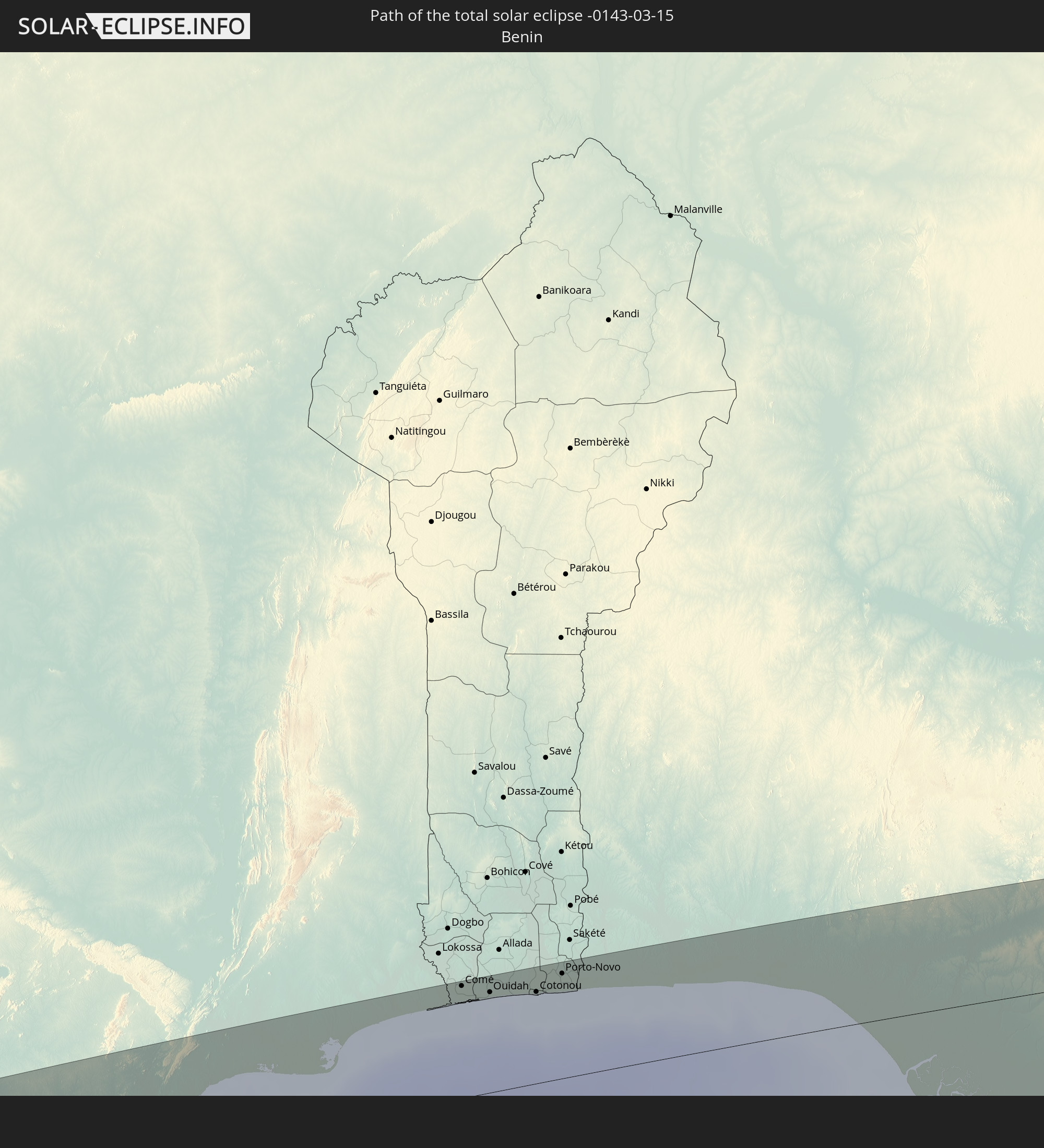 Benin
Benin
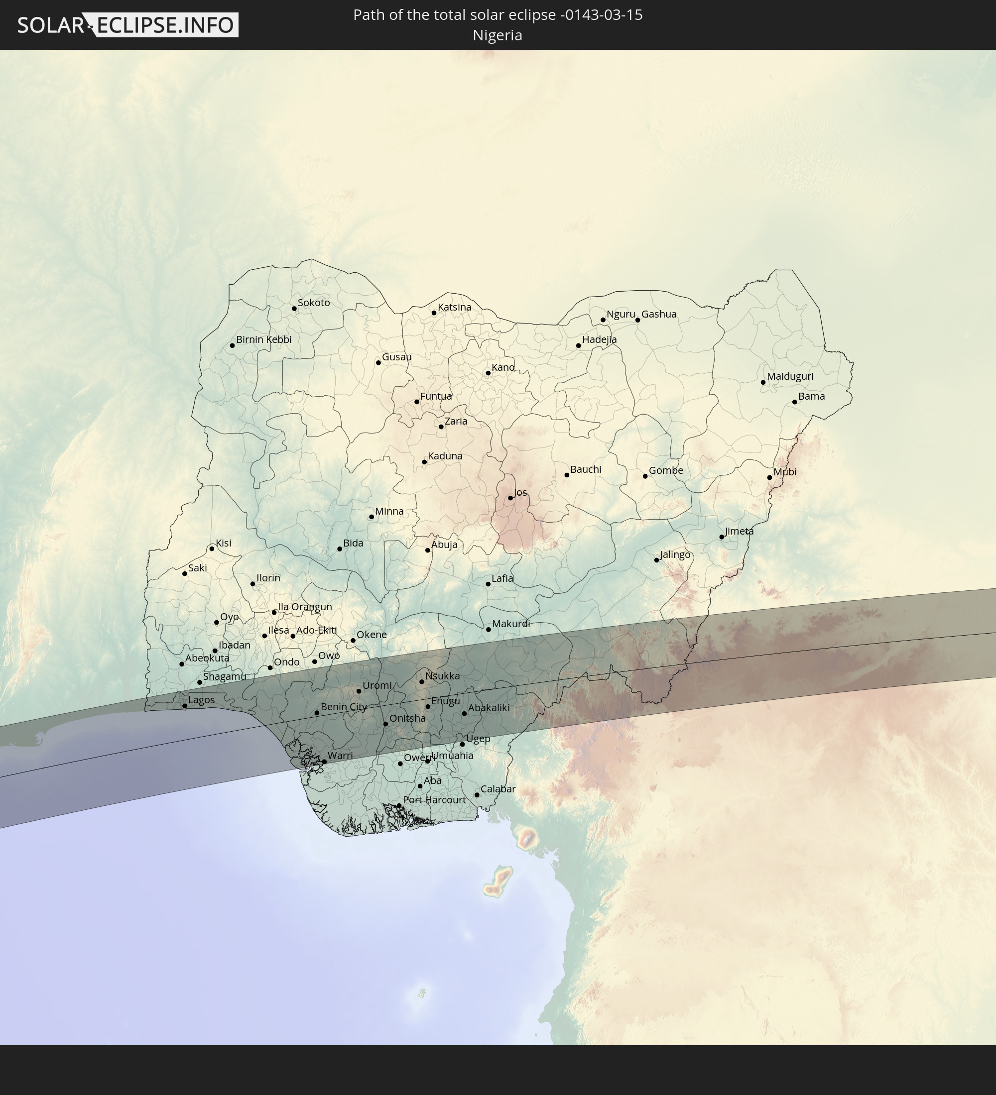 Nigeria
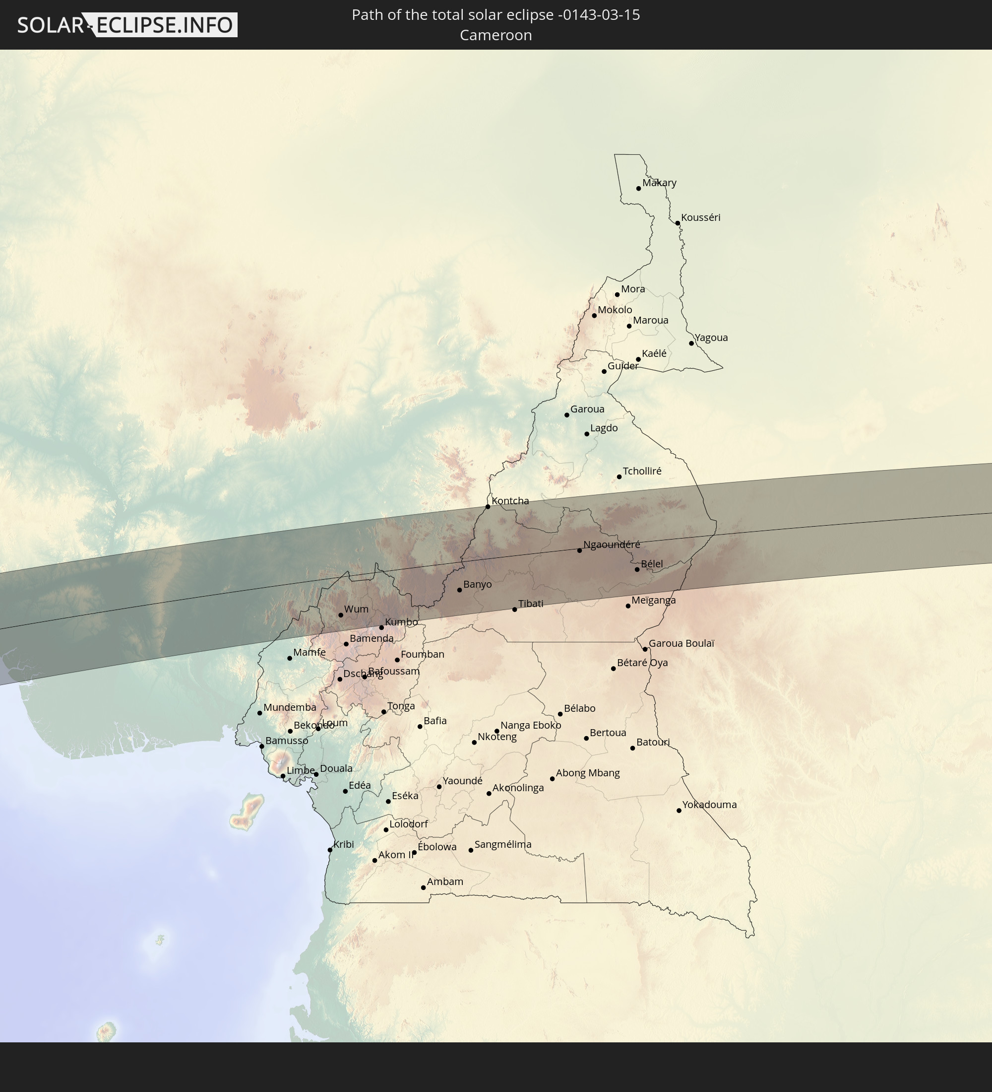 Cameroon
 Chad
Chad
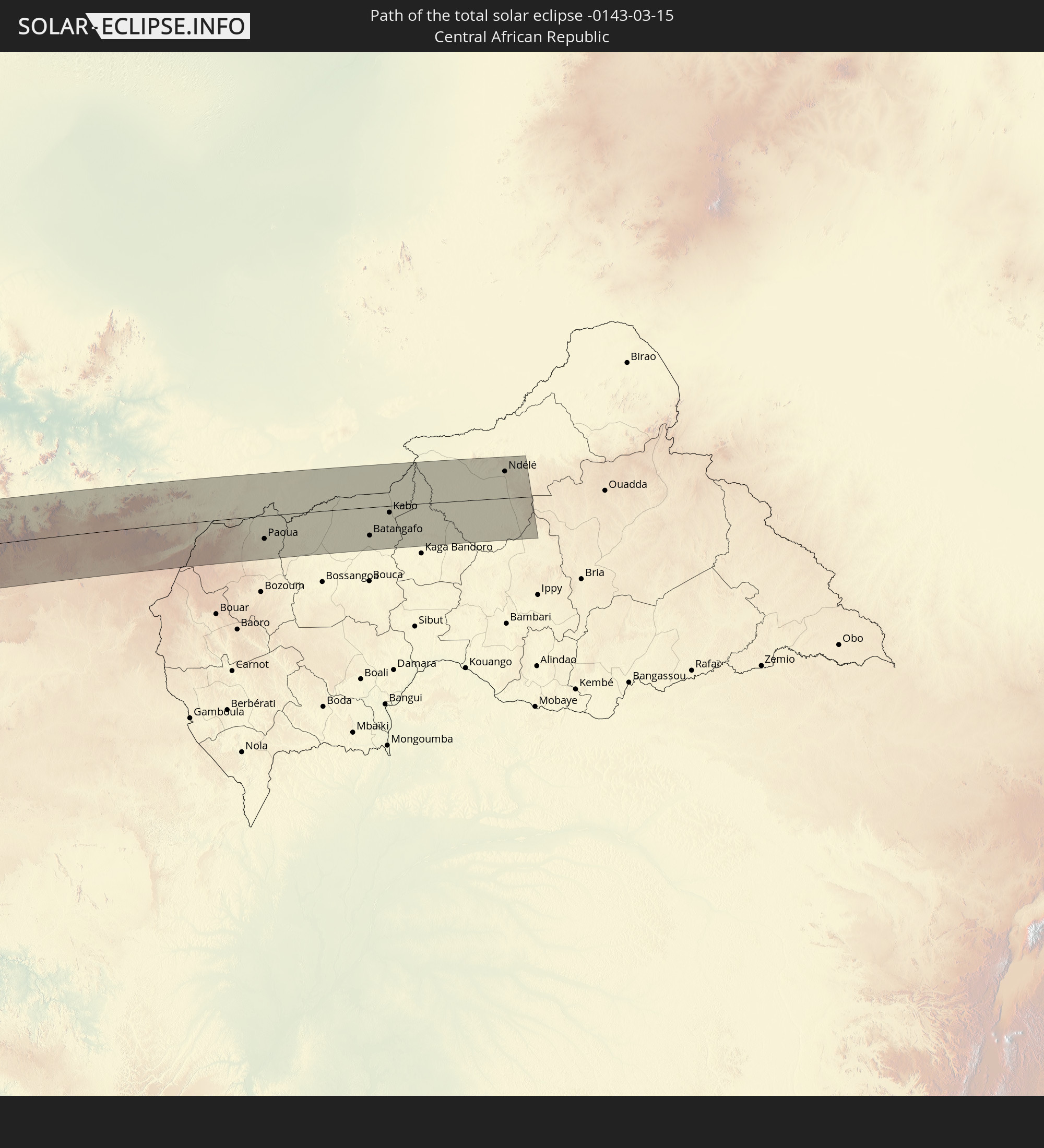 Central African Republic
In den folgenden Ländern ist die Sonnenfinsternis partiell zu sehen
 Chile
Chile
 Ecuador
 Colombia
 Peru
Peru
 Brazil
 Argentina
 Venezuela
 Bolivia
 Paraguay
 Trinidad and Tobago
 Falkland Islands
 Guyana
 Uruguay
 Suriname
 French Guiana
 Portugal
 Cabo Verde
 Spain
Spain
 Senegal
 Mauritania
 The Gambia
 Guinea-Bissau
 Guinea
 Saint Helena, Ascension and Tristan da Cunha
 Sierra Leone
 Morocco
 Mali
Mali
 Liberia
 Algeria
 Ivory Coast
 Burkina Faso
 Ghana
Ghana
 Togo
Togo
 Niger
Niger
 Benin
Benin
 Nigeria
 Equatorial Guinea
 São Tomé and Príncipe
 Italy
Italy
 Tunisia
 Cameroon
 Gabon
Gabon
 Libya
Libya
 Republic of the Congo
 Angola
 Namibia
 Democratic Republic of the Congo
 Chad
Chad
 Malta
Malta
 Central African Republic
 South Africa
 Botswana
 Zambia
 Zimbabwe
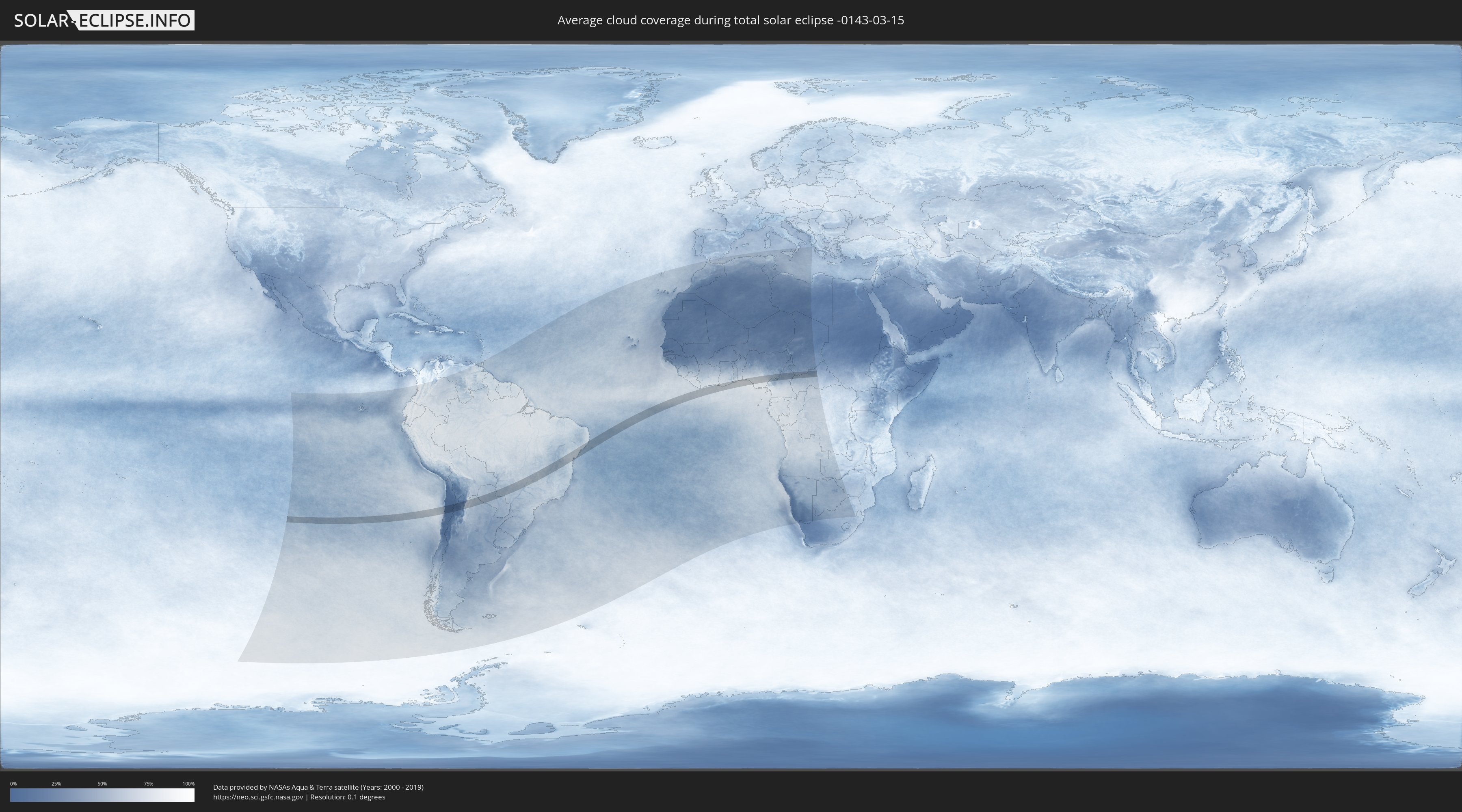
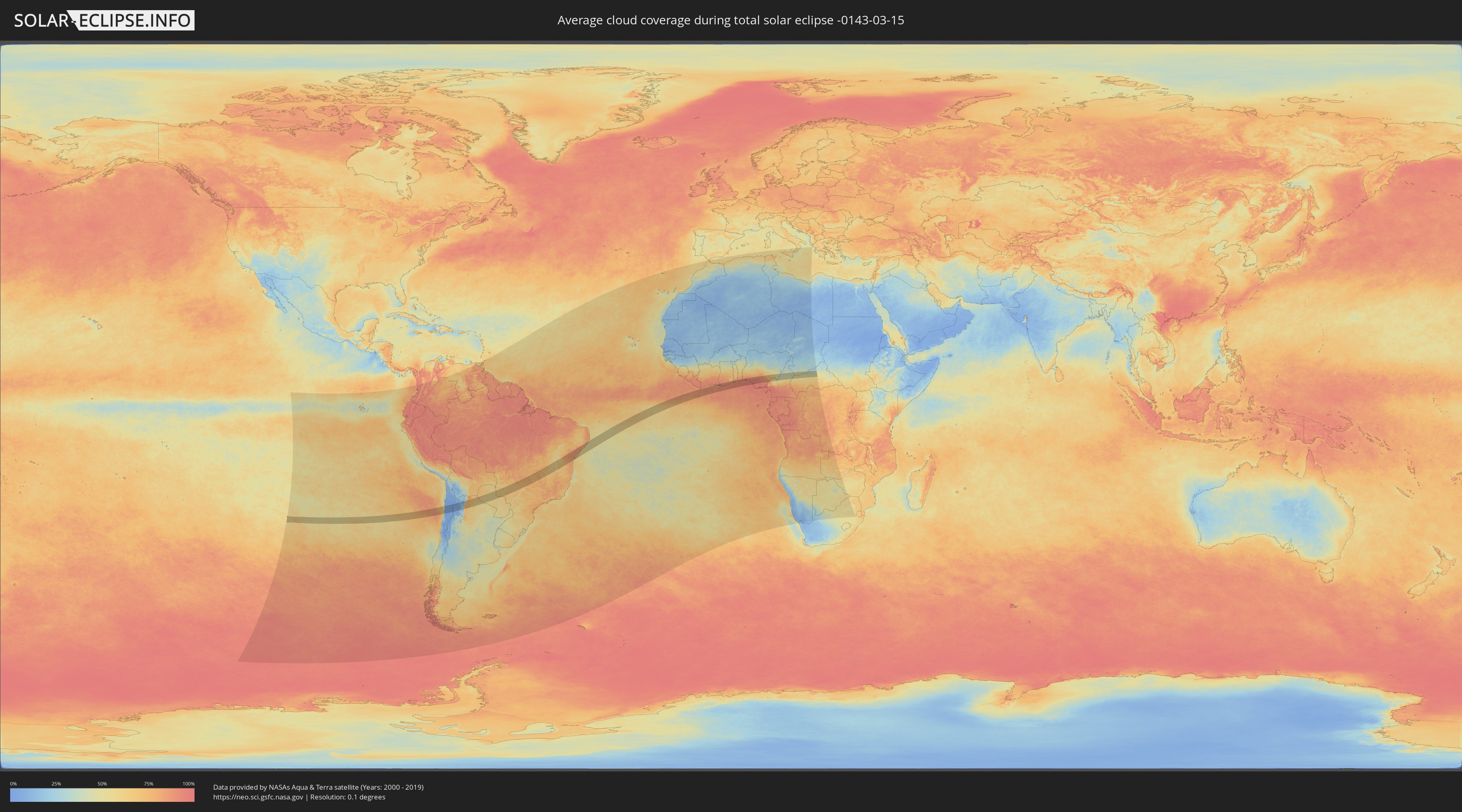
How will be the weather during the total solar eclipse on 03/15/-0143?
Where is the best place to see the total solar eclipse of 03/15/-0143?
The following maps show the average cloud coverage for the day of the total solar eclipse.
With the help of these maps, it is possible to find the place along the eclipse path, which has the best
chance of a cloudless sky.
Nevertheless, you should consider local circumstances and inform about the weather of your chosen
observation site.
The data is provided by NASAs satellites
AQUA and TERRA.
The cloud maps are averaged over a period of 19 years (2000 - 2019).
Detailed country maps
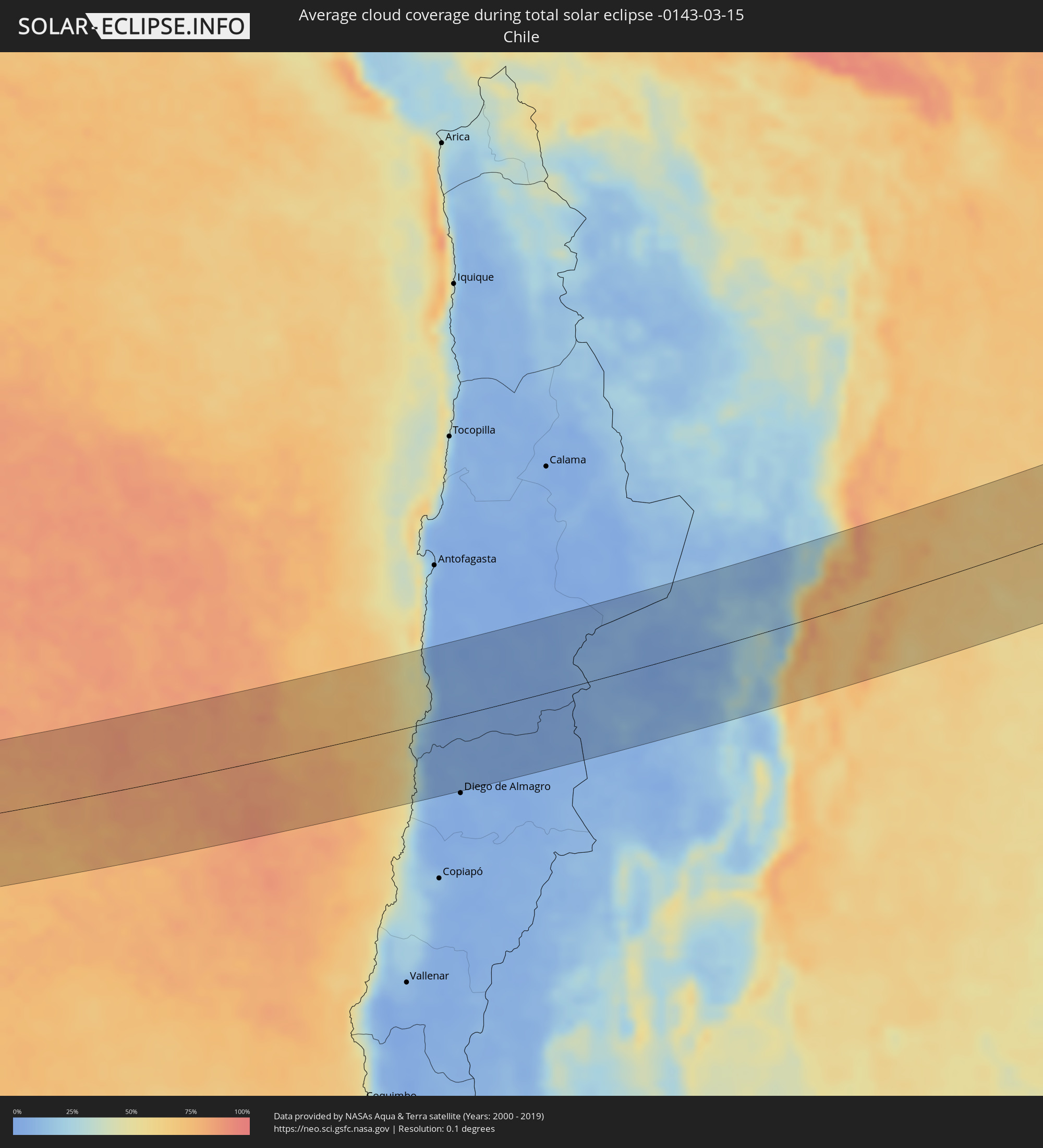 Chile
Chile
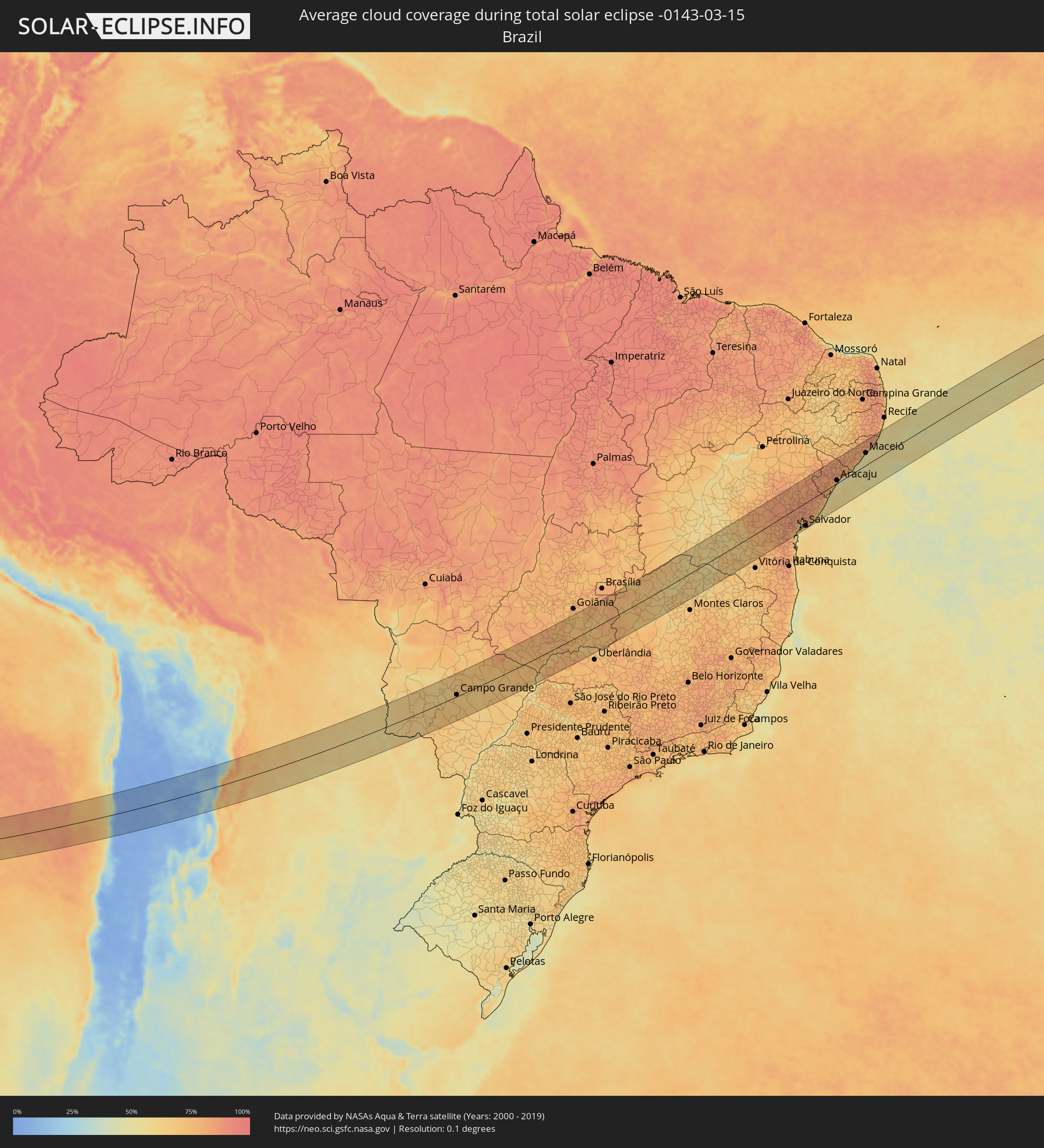 Brazil
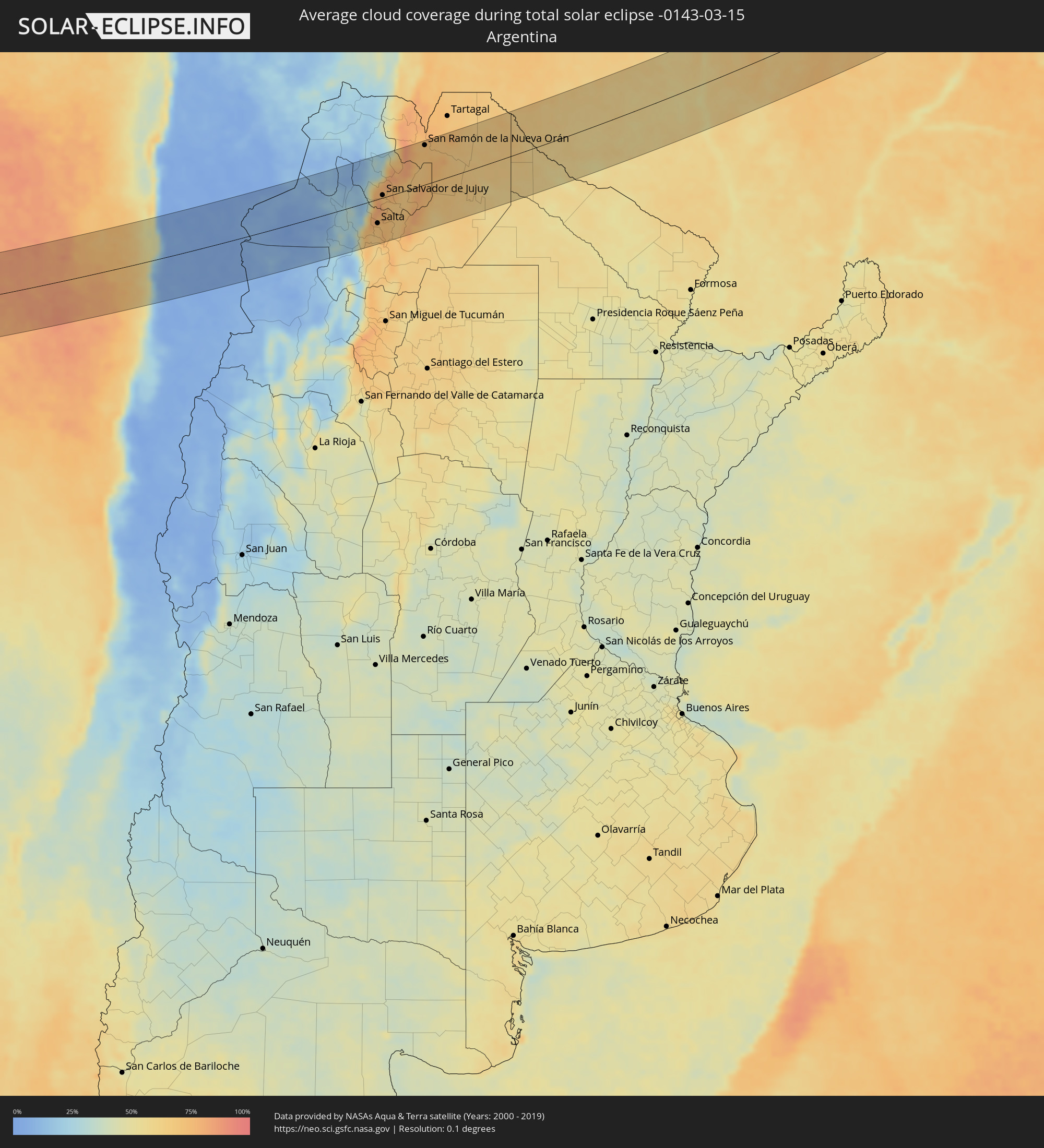 Argentina
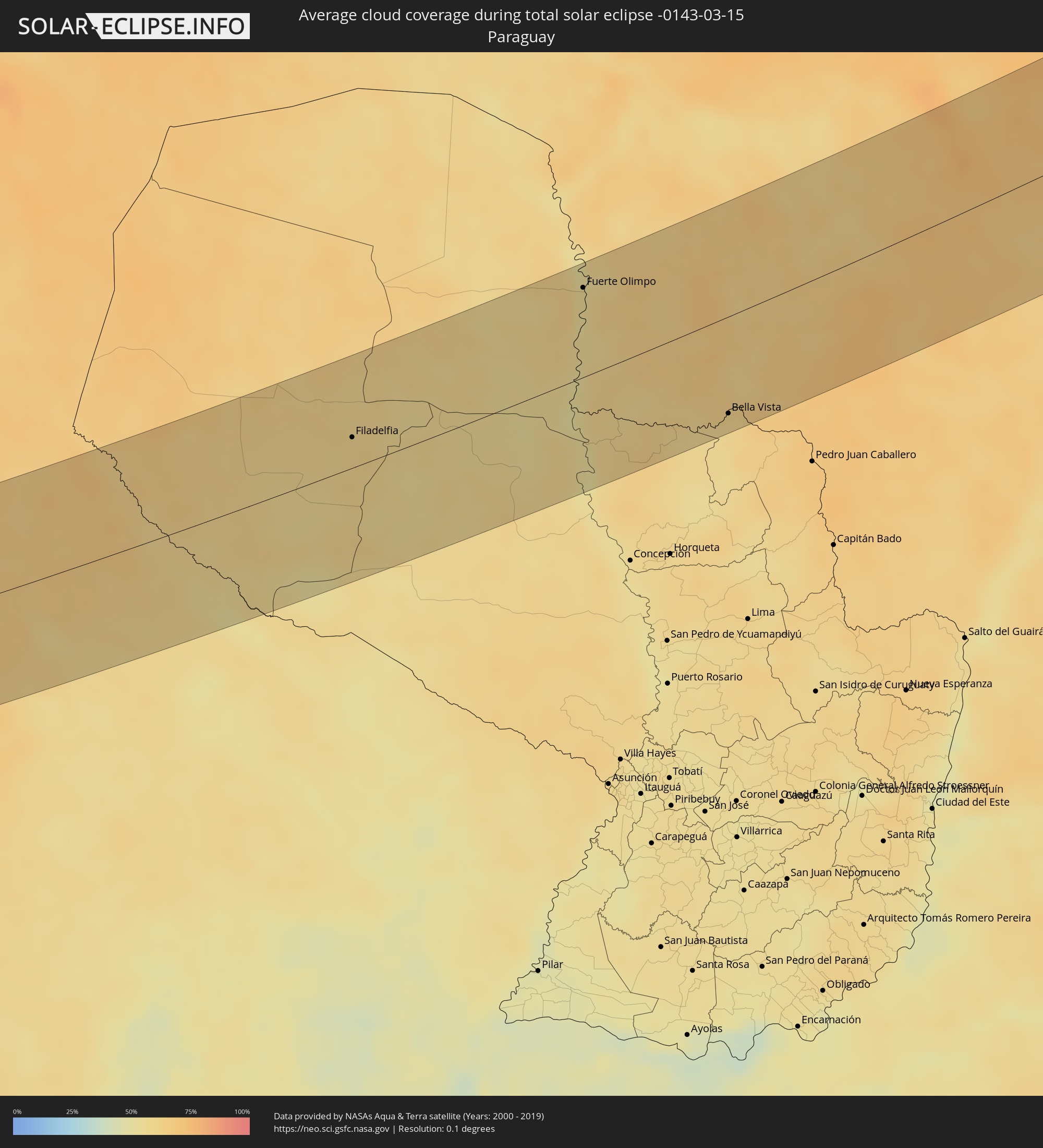 Paraguay
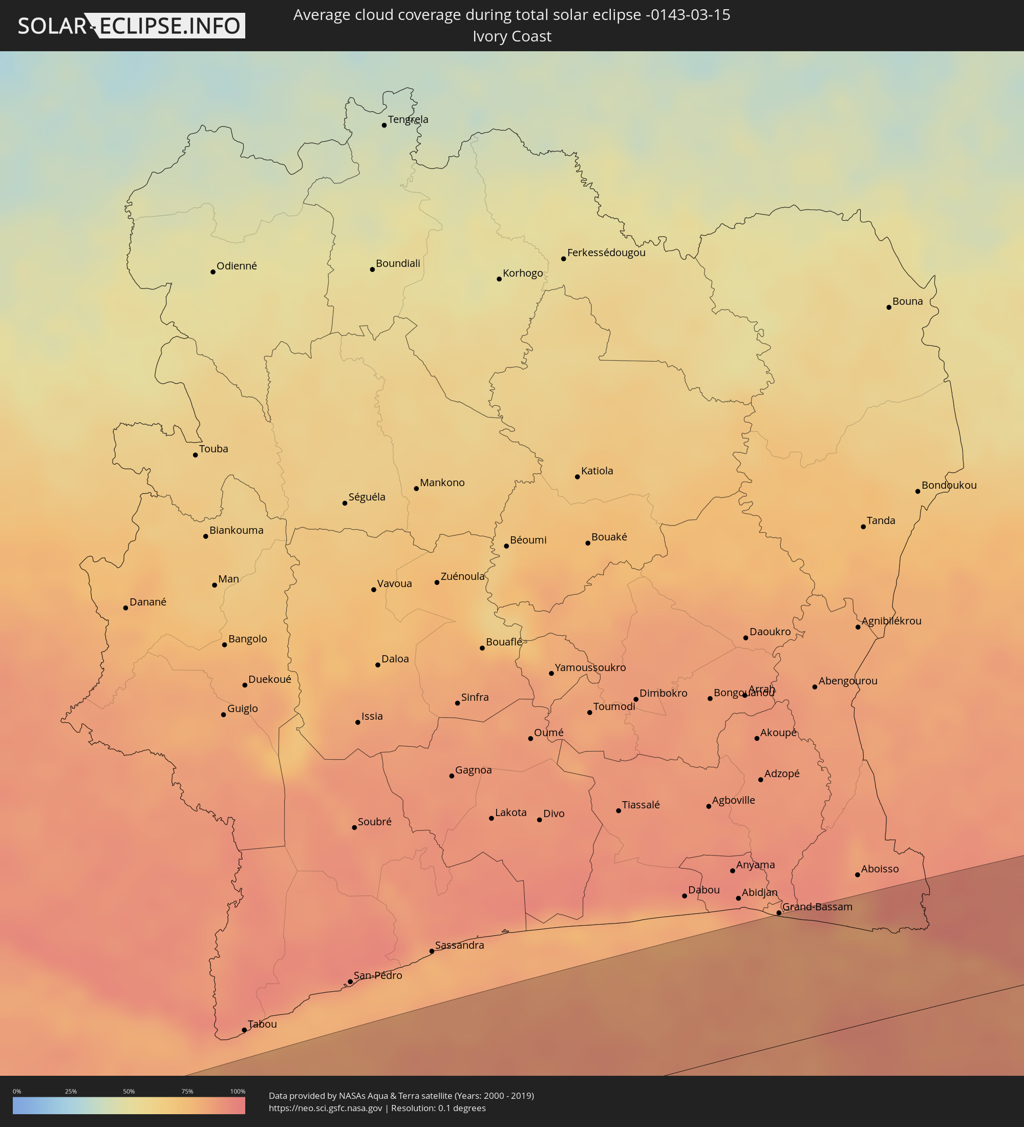 Ivory Coast
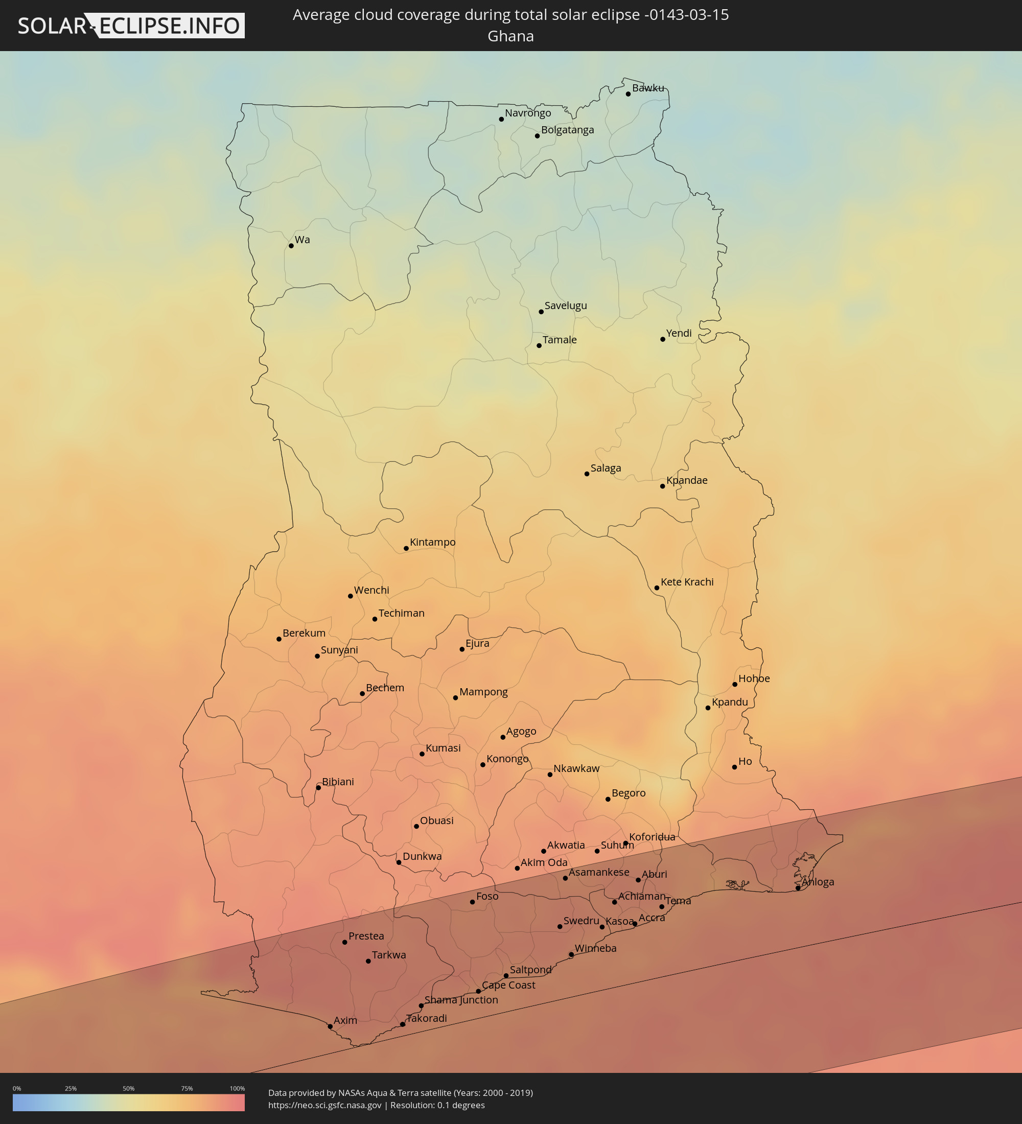 Ghana
Ghana
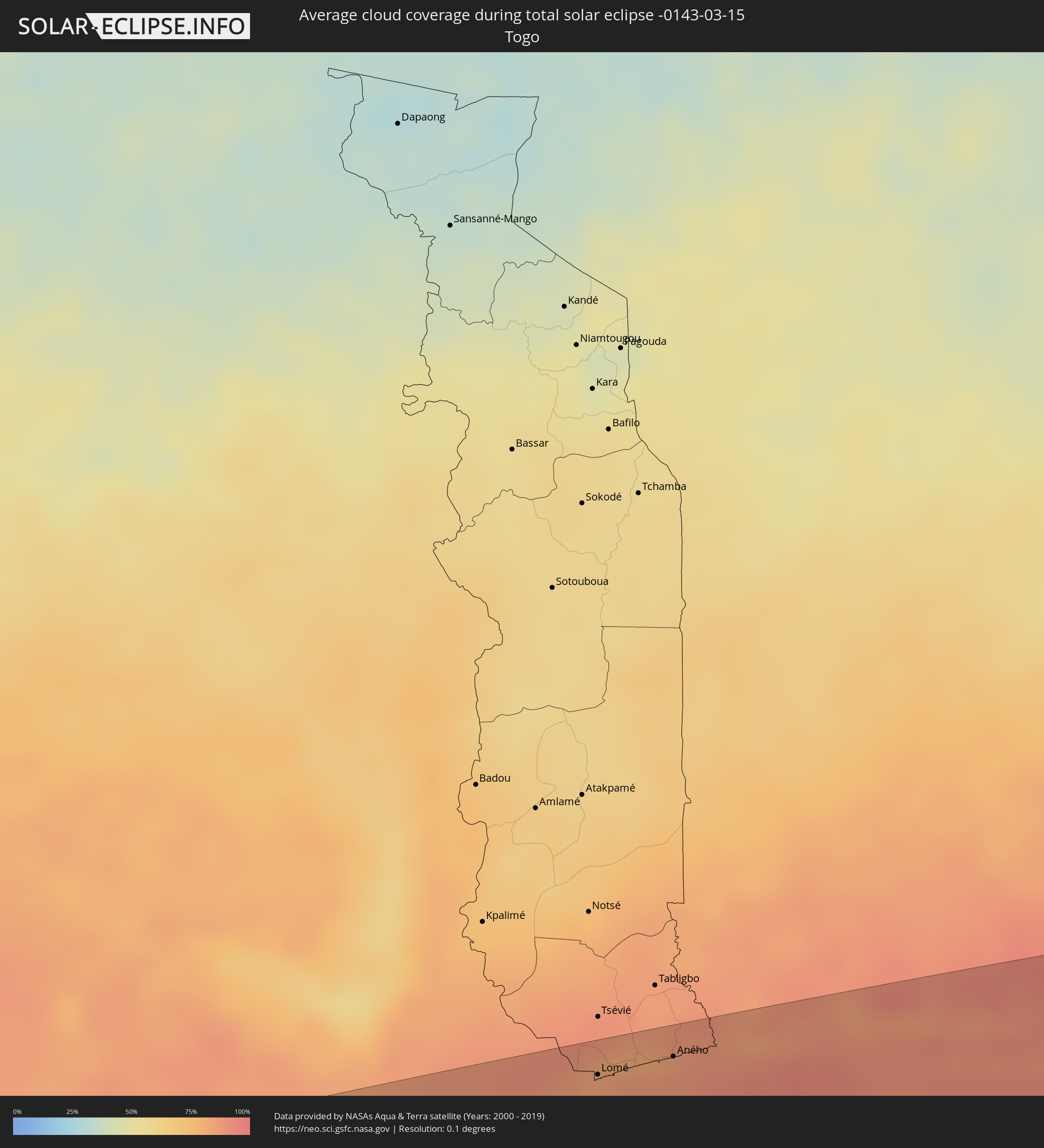 Togo
Togo
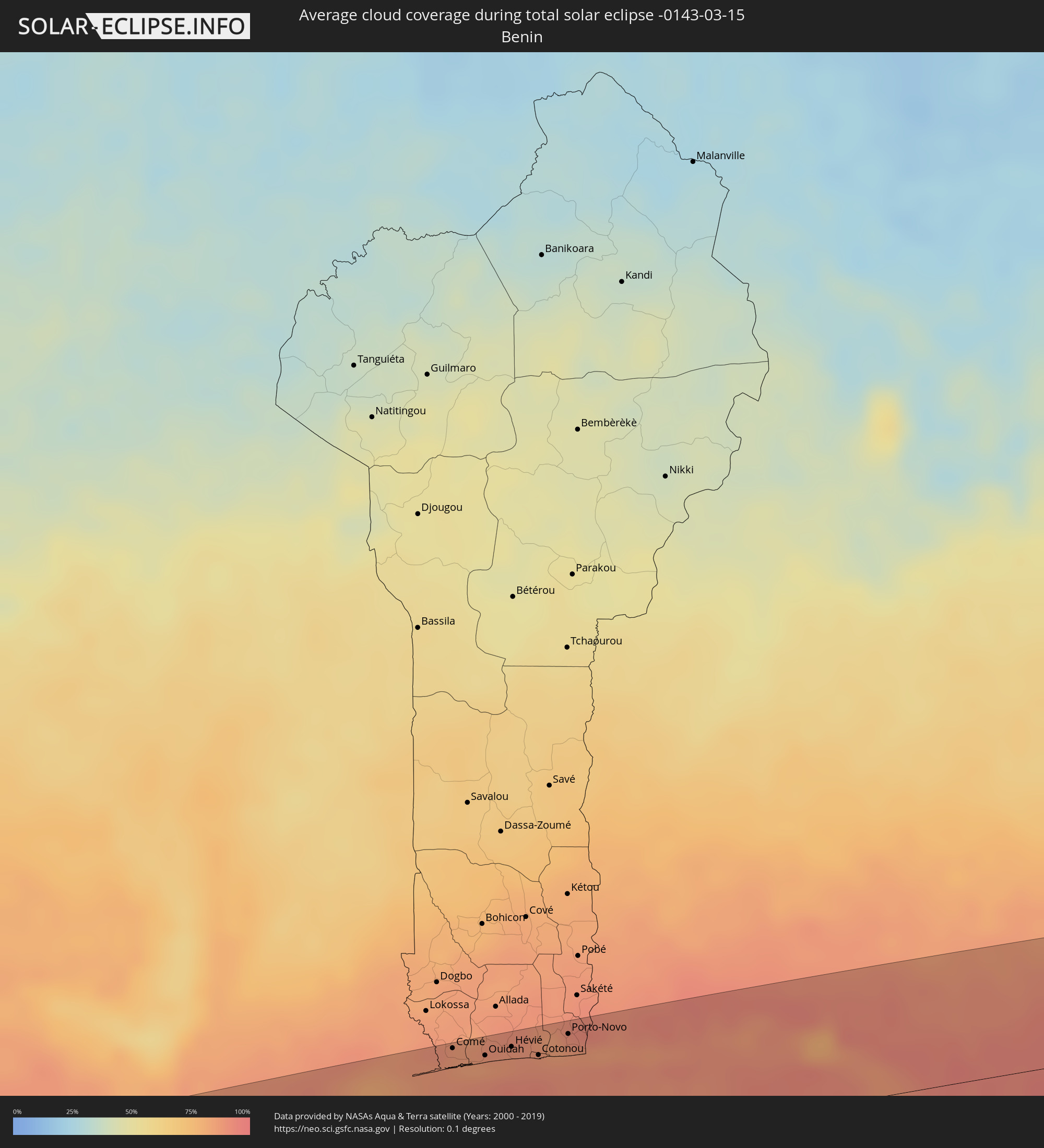 Benin
Benin
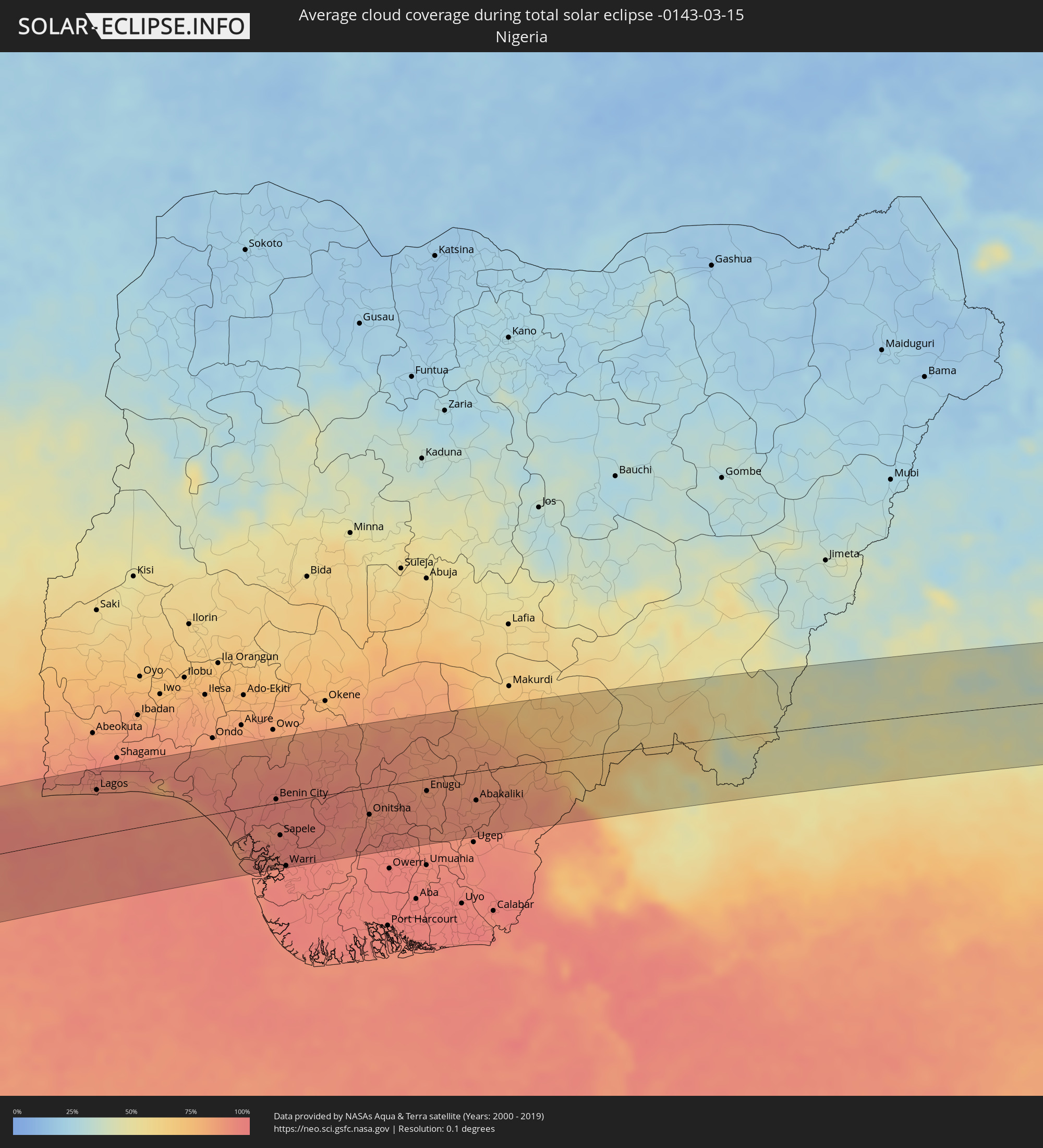 Nigeria
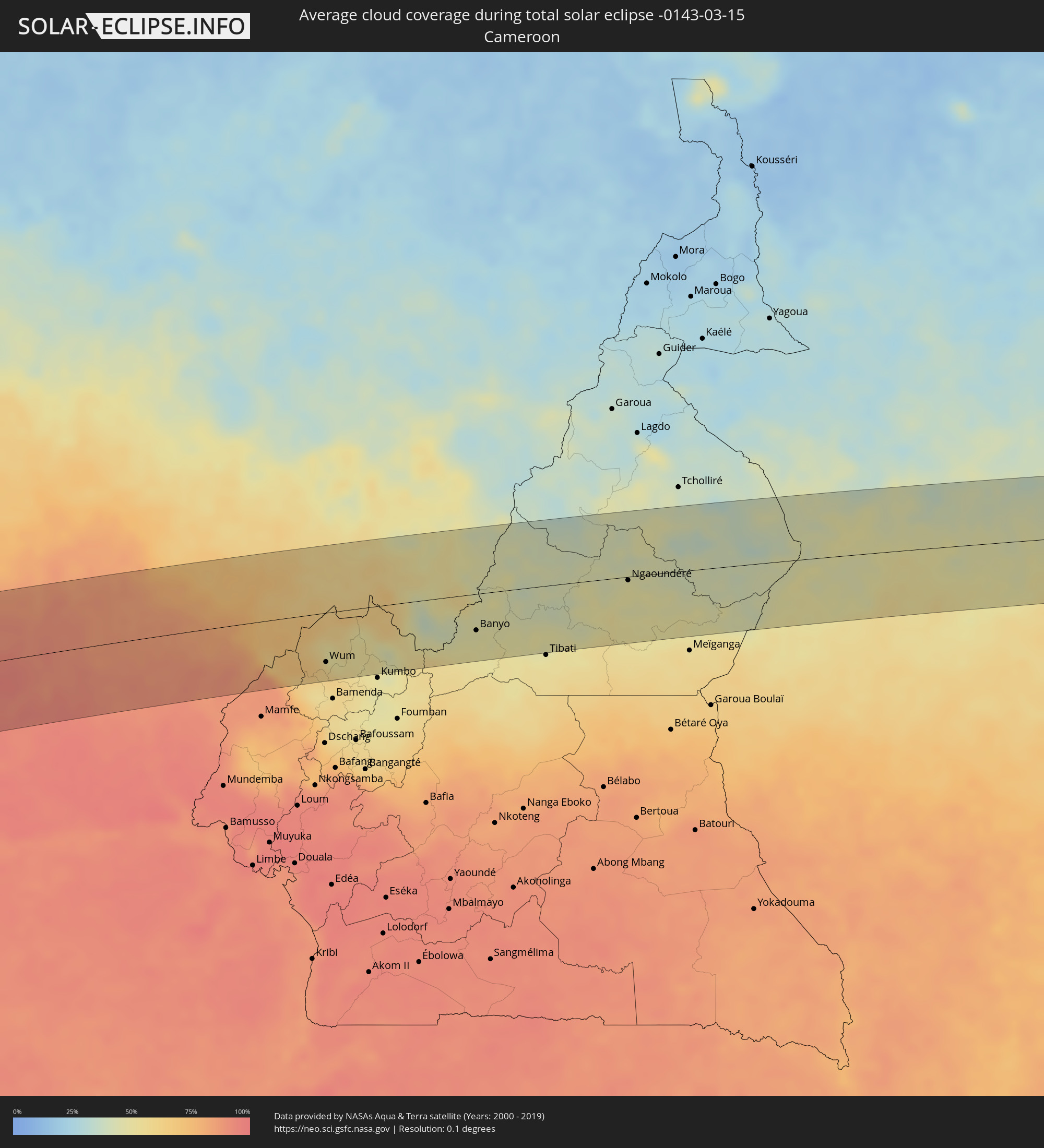 Cameroon
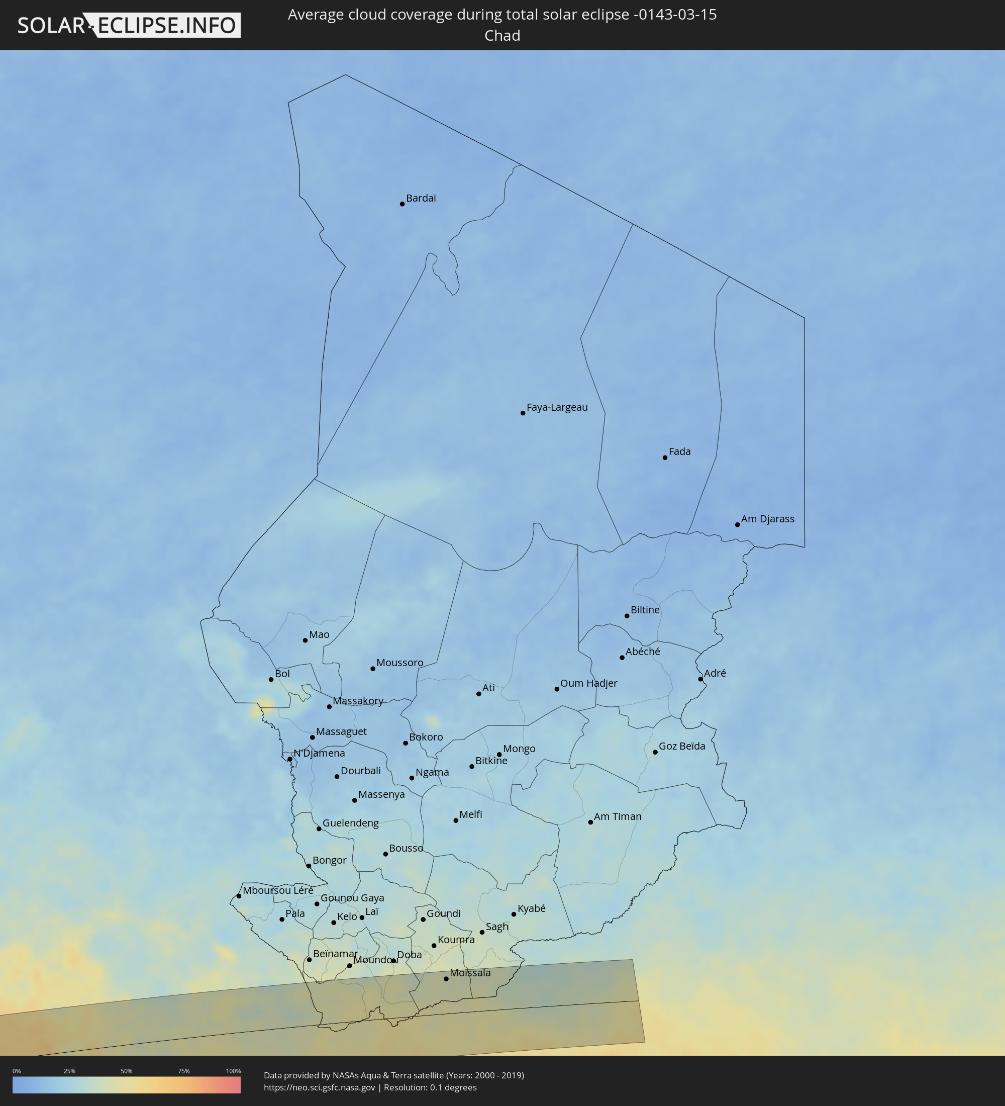 Chad
Chad
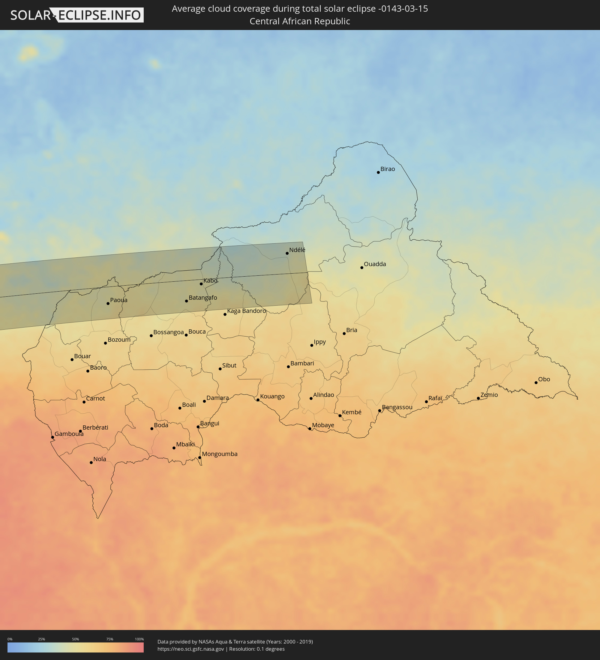 Central African Republic
Cities inside the path of the eclipse
The following table shows all locations with a population of more than 5,000 inside the eclipse path. Cities which have more than 100,000 inhabitants are marked bold. A click at the locations opens a detailed map.
| City | Type | Eclipse duration | Local time of max. eclipse | Distance to central line | Ø Cloud coverage |
|
Taltal, Antofagasta
|
total | - | 09:03:24 UTC-04:42 | 14 km | 26% |
|
Chicoana, Salta Province
|
total | - | 09:37:06 UTC-04:16 | 84 km | 63% |
|
El Carril, Salta Province
|
total | - | 09:37:11 UTC-04:16 | 82 km | 63% |
|
Salta, Salta Province
|
total | - | 09:37:25 UTC-04:16 | 54 km | 70% |
|
Tilcara, Jujuy Province
|
total | - | 09:37:59 UTC-04:16 | 73 km | 27% |
|
San Salvador de Jujuy, Jujuy Province
|
total | - | 09:37:50 UTC-04:16 | 6 km | 73% |
|
Palpalá, Jujuy Province
|
total | - | 09:37:57 UTC-04:16 | 3 km | 71% |
|
San Pedro, Jujuy Province
|
total | - | 09:38:33 UTC-04:16 | 11 km | 67% |
|
Fraile Pintado, Jujuy Province
|
total | - | 09:38:47 UTC-04:16 | 18 km | 67% |
|
Libertador General San Martín, Jujuy Province
|
total | - | 09:38:51 UTC-04:16 | 32 km | 72% |
|
Caimancito, Jujuy Province
|
total | - | 09:39:13 UTC-04:16 | 33 km | 69% |
|
Yuto, Jujuy Province
|
total | - | 09:39:28 UTC-04:16 | 39 km | 67% |
|
San Ramón de la Nueva Orán, Salta Province
|
total | - | 09:39:57 UTC-04:16 | 89 km | 72% |
|
Palma Sola, Jujuy Province
|
total | - | 09:39:38 UTC-04:16 | 0 km | 75% |
|
Las Lajitas, Salta Province
|
total | - | 09:39:25 UTC-04:16 | 78 km | 64% |
|
Embarcación, Salta Province
|
total | - | 09:40:19 UTC-04:16 | 74 km | 69% |
|
Apolinario Saravia, Salta Province
|
total | - | 09:39:57 UTC-04:16 | 59 km | 65% |
|
Ingeniero Guillermo N. Juárez, Formosa Province
|
total | - | 09:44:02 UTC-04:16 | 72 km | 59% |
|
Filadelfia, Boquerón
|
total | - | 10:14:31 UTC-03:50 | 27 km | 60% |
|
Colonia Menno, Boquerón
|
total | - | 10:14:55 UTC-03:50 | 17 km | 60% |
|
Fuerte Olimpo, Alto Paraguay
|
total | - | 10:19:46 UTC-03:50 | 80 km | 56% |
|
Bella Vista, Amambay
|
total | - | 10:21:44 UTC-03:50 | 86 km | 60% |
|
Campo Grande, Mato Grosso do Sul
|
total | - | 10:39:21 UTC-03:38 | 8 km | 71% |
|
Ituiutaba, Minas Gerais
|
total | - | 11:24:38 UTC-03:06 | 84 km | 77% |
|
Itumbiara, Goiás
|
total | - | 11:25:52 UTC-03:06 | 42 km | 72% |
|
Caldas Novas, Goiás
|
total | - | 11:28:04 UTC-03:06 | 5 km | 70% |
|
Paracatu, Minas Gerais
|
total | - | 11:32:57 UTC-03:06 | 43 km | 74% |
|
Jequié, Bahia
|
total | - | 12:26:59 UTC-02:34 | 93 km | 75% |
|
Santo Antônio de Jesus, Bahia
|
total | - | 12:30:24 UTC-02:34 | 55 km | 82% |
|
Feira de Santana, Bahia
|
total | - | 12:32:14 UTC-02:34 | 6 km | 83% |
|
Salvador, Bahia
|
total | - | 12:32:16 UTC-02:34 | 99 km | 62% |
|
Alagoinhas, Bahia
|
total | - | 12:33:48 UTC-02:34 | 25 km | 84% |
|
Lauro de Freitas, Bahia
|
total | - | 12:32:51 UTC-02:34 | 102 km | 60% |
|
Camaçari, Bahia
|
total | - | 12:33:10 UTC-02:34 | 84 km | 74% |
|
Itabaiana, Sergipe
|
total | - | 12:38:35 UTC-02:34 | 54 km | 82% |
|
São Cristóvão, Sergipe
|
total | - | 12:38:36 UTC-02:34 | 11 km | 65% |
|
Aracaju, Sergipe
|
total | - | 12:39:06 UTC-02:34 | 13 km | 68% |
|
Arapiraca, Alagoas
|
total | - | 12:41:58 UTC-02:34 | 98 km | 79% |
|
Maceió, Alagoas
|
total | - | 12:44:23 UTC-02:34 | 53 km | 48% |
|
Adiaké, Comoé
|
total | - | 16:17:20 UTC-00:16 | 92 km | 85% |
|
Axim, Western
|
total | - | 16:33:13 UTC-00:00 | 19 km | 85% |
|
Prestea, Western
|
total | - | 16:33:42 UTC-00:00 | 77 km | 92% |
|
Tarkwa, Western
|
total | - | 16:33:44 UTC-00:00 | 59 km | 91% |
|
Takoradi, Western
|
total | - | 16:33:38 UTC-00:00 | 8 km | 87% |
|
Shama Junction, Western
|
total | - | 16:33:49 UTC-00:00 | 18 km | 86% |
|
Elmina, Central
|
total | - | 16:34:06 UTC-00:00 | 19 km | 85% |
|
Cape Coast, Central
|
total | - | 16:34:12 UTC-00:00 | 19 km | 86% |
|
Saltpond, Central
|
total | - | 16:34:25 UTC-00:00 | 26 km | 84% |
|
Apam, Central
|
total | - | 16:34:43 UTC-00:00 | 26 km | 86% |
|
Swedru, Central
|
total | - | 16:34:55 UTC-00:00 | 52 km | 89% |
|
Asamankese, Eastern
|
total | - | 16:35:10 UTC-00:00 | 86 km | 86% |
|
Winneba, Central
|
total | - | 16:34:51 UTC-00:00 | 30 km | 85% |
|
Kasoa, Central
|
total | - | 16:35:08 UTC-00:00 | 45 km | 86% |
|
Achiaman, Greater Accra
|
total | - | 16:35:19 UTC-00:00 | 61 km | 87% |
|
Accra, Greater Accra
|
total | - | 16:35:19 UTC-00:00 | 42 km | 85% |
|
Tema, Greater Accra
|
total | - | 16:35:31 UTC-00:00 | 50 km | 83% |
|
Anloga, Volta
|
total | - | 16:36:16 UTC-00:00 | 43 km | 86% |
|
Lomé, Maritime
|
total | - | 16:21:26 UTC-00:16 | 73 km | 85% |
|
Vogan, Maritime
|
total | - | 16:21:46 UTC-00:16 | 87 km | 82% |
|
Aného, Maritime
|
total | - | 16:21:44 UTC-00:16 | 74 km | 87% |
|
Grand-Popo, Mono
|
total | - | 16:51:38 UTC+00:13 | 75 km | 87% |
|
Comé, Mono
|
total | - | 16:51:45 UTC+00:13 | 88 km | 85% |
|
Ouidah, Atlantique
|
total | - | 16:51:52 UTC+00:13 | 78 km | 85% |
|
Hévié, Atlantique
|
total | - | 16:52:00 UTC+00:13 | 81 km | 89% |
|
Abomey-Calavi, Atlantique
|
total | - | 16:52:05 UTC+00:13 | 82 km | 89% |
|
Cotonou, Littoral
|
total | - | 16:52:04 UTC+00:13 | 72 km | 89% |
|
Porto-Novo, Ouémé
|
total | - | 16:52:16 UTC+00:13 | 82 km | 86% |
|
Ikeja, Lagos
|
total | - | 16:52:46 UTC+00:13 | 78 km | 91% |
|
Lagos, Lagos
|
total | - | 16:52:43 UTC+00:13 | 61 km | 90% |
|
Ebute Ikorodu, Lagos
|
total | - | 16:52:52 UTC+00:13 | 75 km | 88% |
|
Epe, Lagos
|
total | - | 16:53:08 UTC+00:13 | 63 km | 87% |
|
Benin City, Edo
|
total | - | 16:53:53 UTC+00:13 | 5 km | 95% |
|
Sapele, Delta
|
total | - | 16:53:40 UTC+00:13 | 45 km | 94% |
|
Warri, Delta
|
total | - | 16:53:29 UTC+00:13 | 87 km | 95% |
|
Uromi, Edo
|
total | - | 16:54:26 UTC+00:13 | 32 km | 90% |
|
Onitsha, Anambra
|
total | - | 16:54:21 UTC+00:13 | 36 km | 89% |
|
Ihiala, Anambra
|
total | - | 16:54:13 UTC+00:13 | 70 km | 93% |
|
Nnewi, Anambra
|
total | - | 16:54:20 UTC+00:13 | 53 km | 93% |
|
Awka, Anambra
|
total | - | 16:54:31 UTC+00:13 | 34 km | 90% |
|
Okigwe, Imo
|
total | - | 16:54:26 UTC+00:13 | 81 km | 91% |
|
Nsukka, Enugu
|
total | - | 16:55:00 UTC+00:13 | 31 km | 86% |
|
Enugu, Enugu
|
total | - | 16:54:49 UTC+00:13 | 16 km | 88% |
|
Effium, Ebonyi
|
total | - | 16:55:09 UTC+00:13 | 5 km | 86% |
|
Abakaliki, Ebonyi
|
total | - | 16:55:01 UTC+00:13 | 39 km | 88% |
|
Wum, North-West
|
total | - | 16:55:48 UTC+00:13 | 63 km | 57% |
|
Mme-Bafumen, North-West
|
total | - | 16:55:50 UTC+00:13 | 71 km | 60% |
|
Fundong, North-West
|
total | - | 16:55:48 UTC+00:13 | 80 km | 57% |
|
Njinikom, North-West
|
total | - | 16:55:48 UTC+00:13 | 82 km | 59% |
|
Banyo, Adamaoua
|
total | - | 16:56:31 UTC+00:13 | 46 km | 47% |
|
Kontcha, Adamaoua
|
total | - | 16:57:10 UTC+00:13 | 83 km | 42% |
|
Ngaoundéré, Adamaoua
|
total | - | 16:57:13 UTC+00:13 | 4 km | 49% |
|
Bélel, Adamaoua
|
total | - | 16:57:16 UTC+00:13 | 45 km | 49% |
|
Paoua, Ouham-Pendé
|
total | - | 16:57:40 UTC+00:13 | 44 km | 47% |
|
Béboto, Logone Oriental
|
total | - | 17:44:44 UTC+01:00 | 65 km | 45% |
|
Moïssala, Mandoul
|
total | - | 17:44:50 UTC+01:00 | 65 km | 40% |
|
Batangafo, Ouham
|
total | - | 16:57:52 UTC+00:13 | 54 km | 49% |
|
Kabo, Ouham
|
total | - | 16:58:02 UTC+00:13 | 13 km | 46% |
|
Ndélé, Bamingui-Bangoran
|
total | - | 16:58:20 UTC+00:13 | 51 km | 39% |