Total solar eclipse of 06/12/-0352
| Day of week: | Wednesday |
| Maximum duration of eclipse: | 02m11s |
| Maximum width of eclipse path: | 106 km |
| Saros cycle: | 70 |
| Coverage: | 100% |
| Magnitude: | 1.0213 |
| Gamma: | -0.7303 |
Wo kann man die Sonnenfinsternis vom 06/12/-0352 sehen?
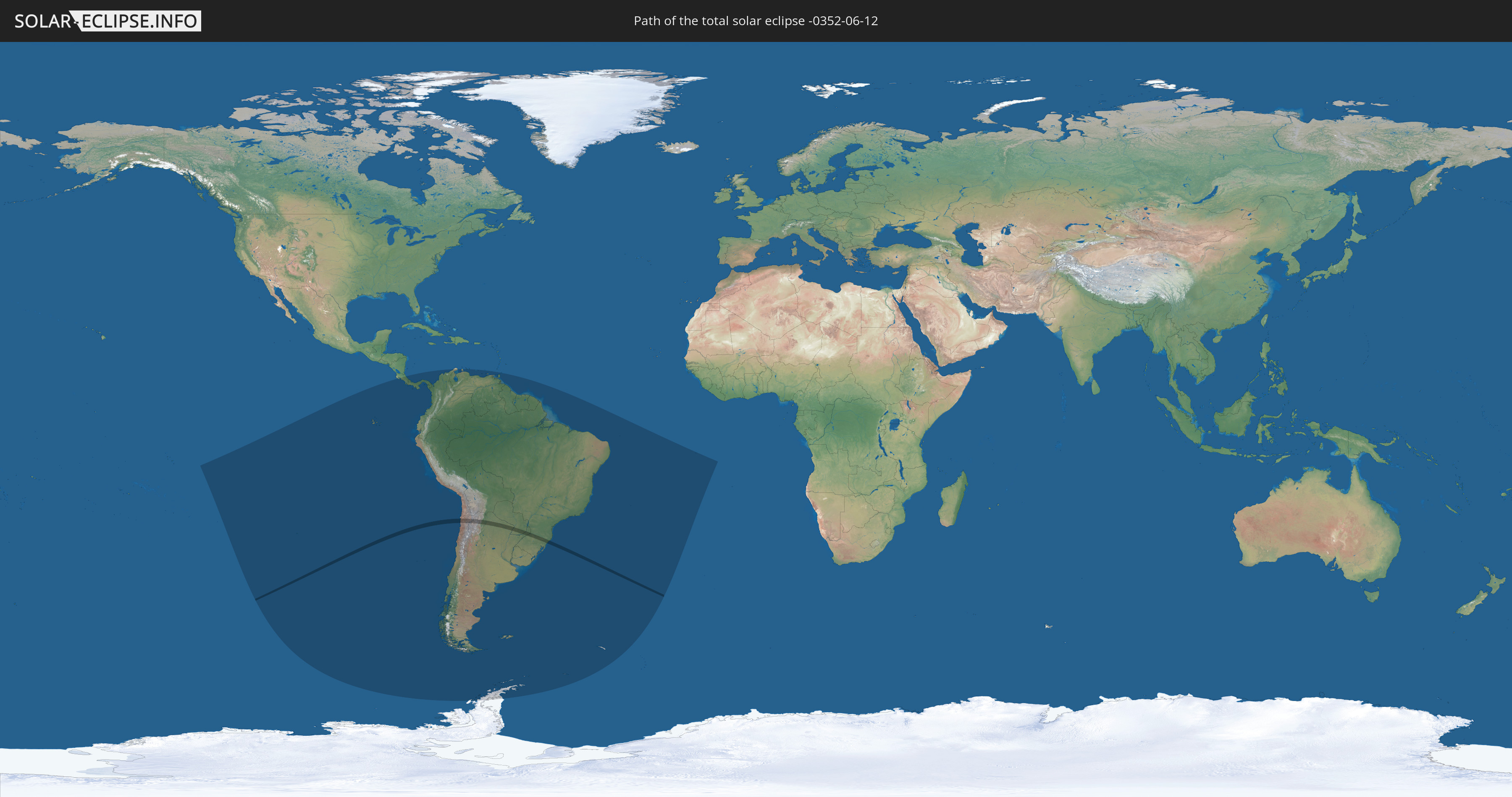
Die Sonnenfinsternis am 06/12/-0352 kann man in 21 Ländern als partielle Sonnenfinsternis beobachten.
Der Finsternispfad verläuft durch 4 Länder. Nur in diesen Ländern ist sie als total Sonnenfinsternis zu sehen.
In den folgenden Ländern ist die Sonnenfinsternis total zu sehen
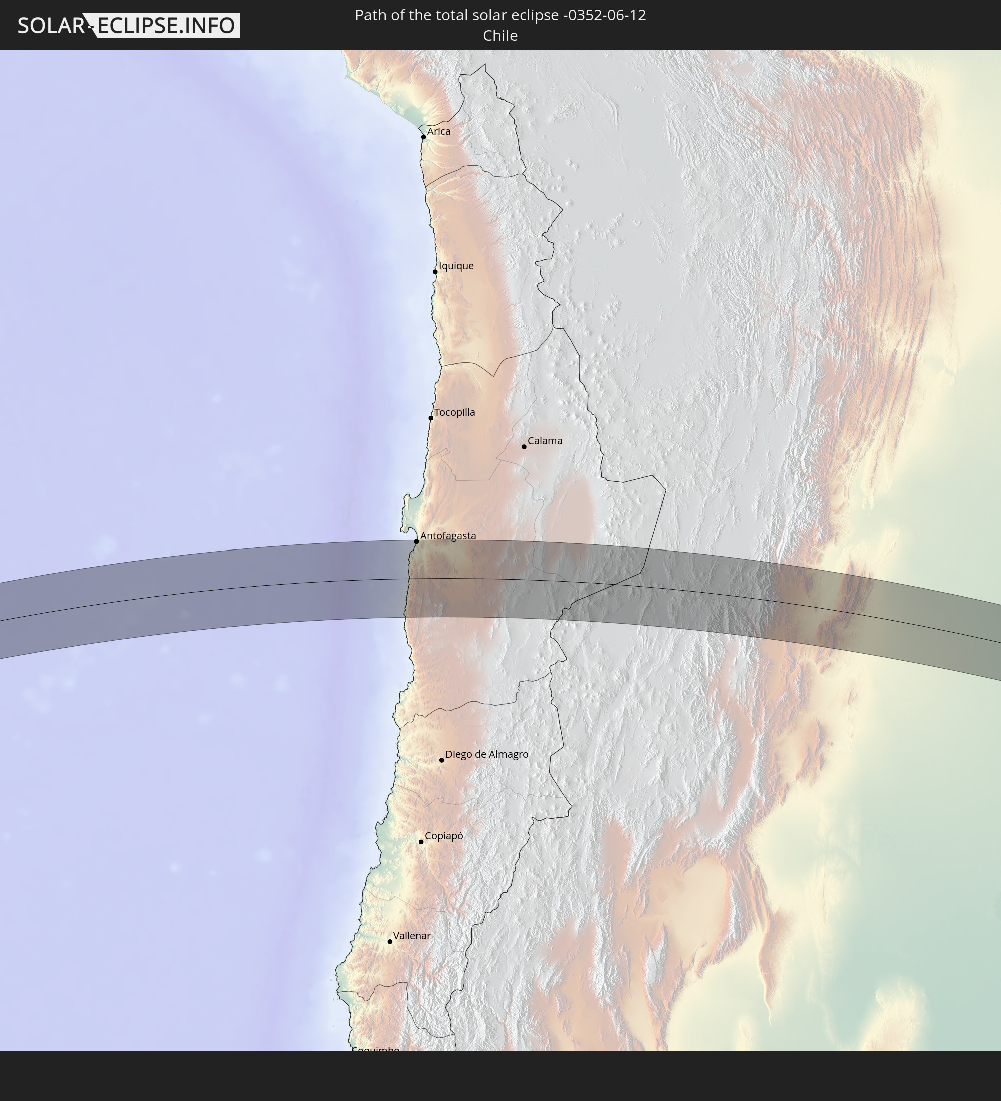 Chile
Chile
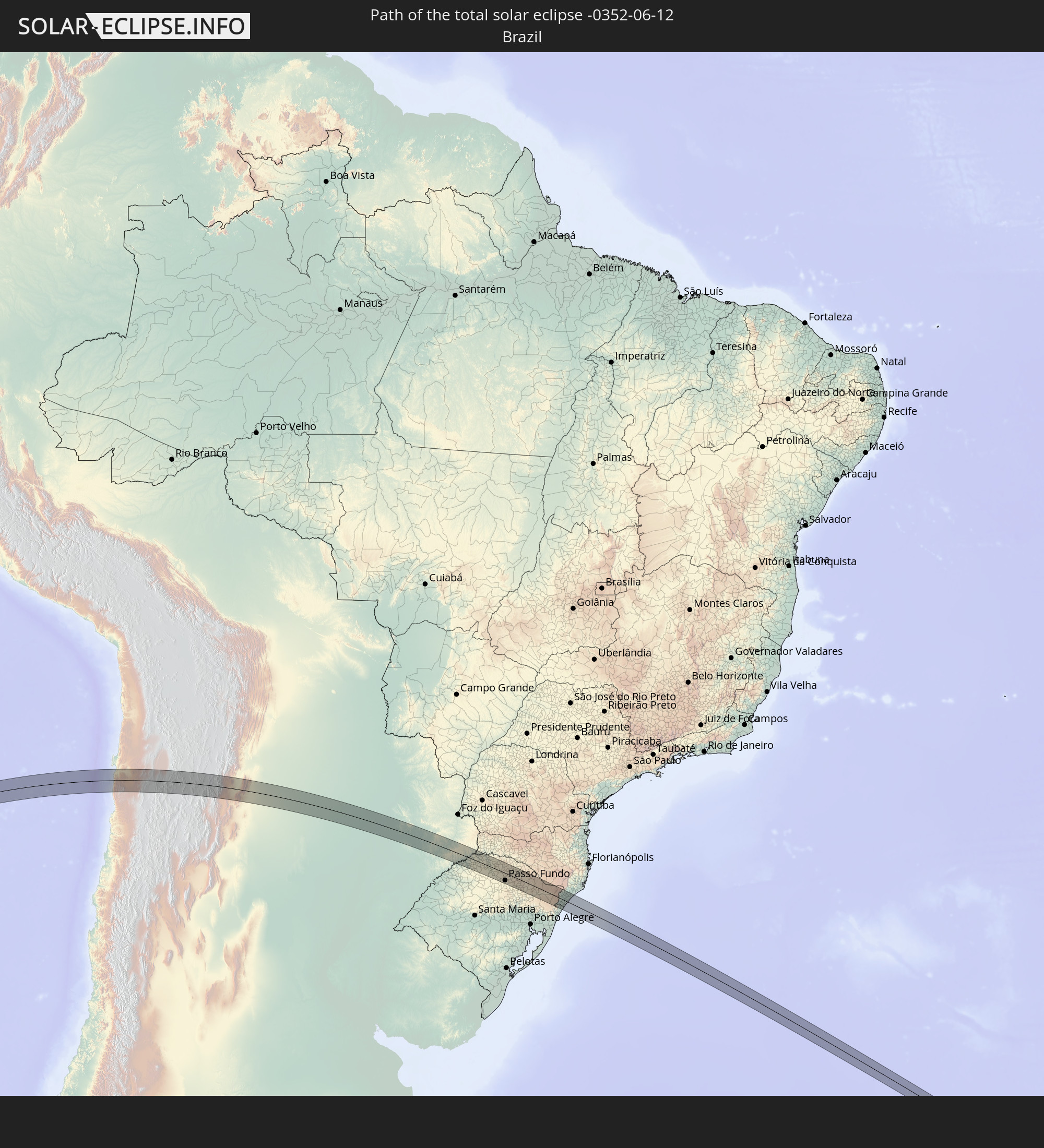 Brazil
 Argentina
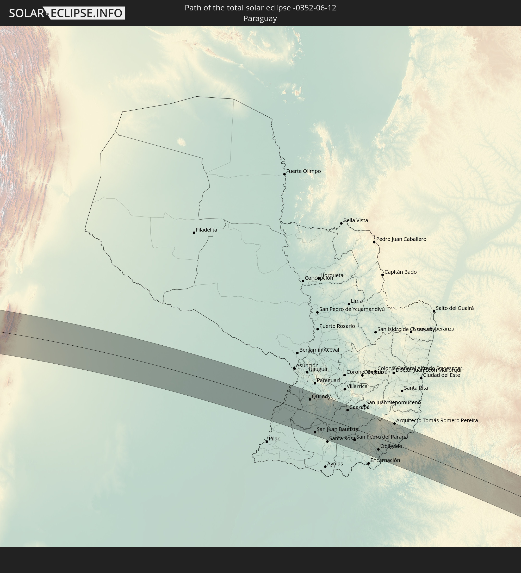 Paraguay
In den folgenden Ländern ist die Sonnenfinsternis partiell zu sehen


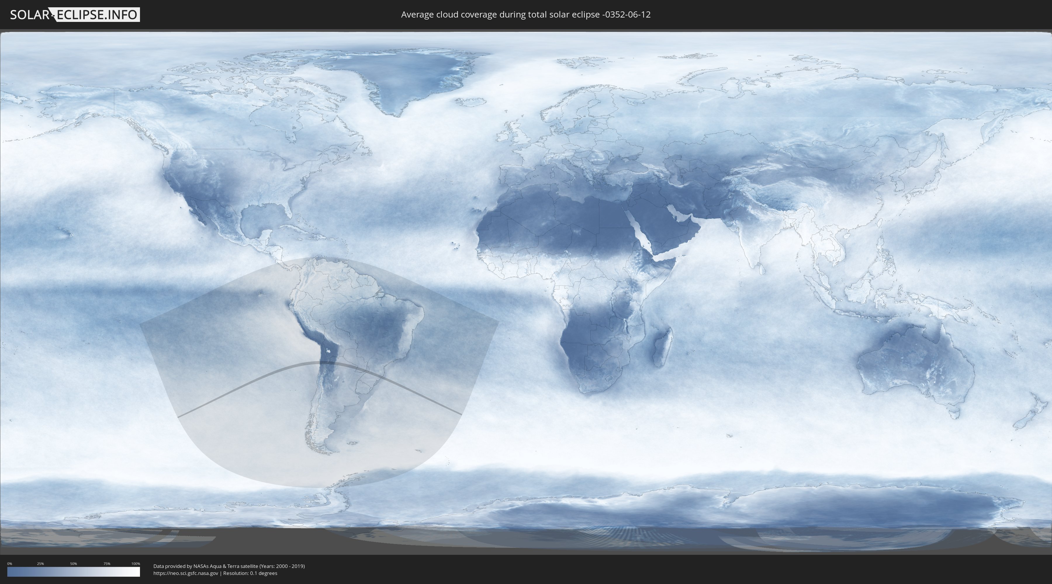
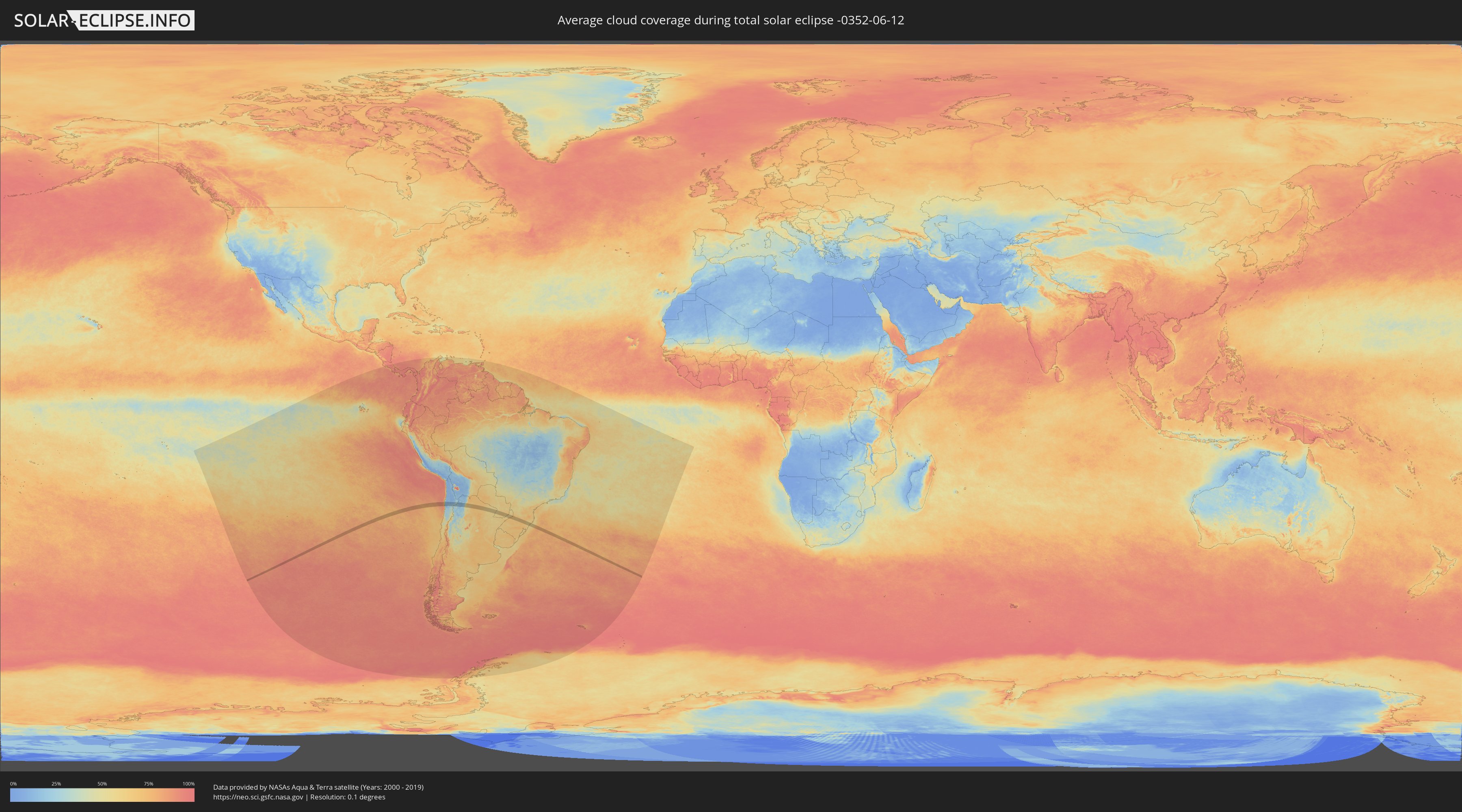
How will be the weather during the total solar eclipse on 06/12/-0352?
Where is the best place to see the total solar eclipse of 06/12/-0352?
The following maps show the average cloud coverage for the day of the total solar eclipse.
With the help of these maps, it is possible to find the place along the eclipse path, which has the best
chance of a cloudless sky.
Nevertheless, you should consider local circumstances and inform about the weather of your chosen
observation site.
The data is provided by NASAs satellites
AQUA and TERRA.
The cloud maps are averaged over a period of 19 years (2000 - 2019).
Detailed country maps
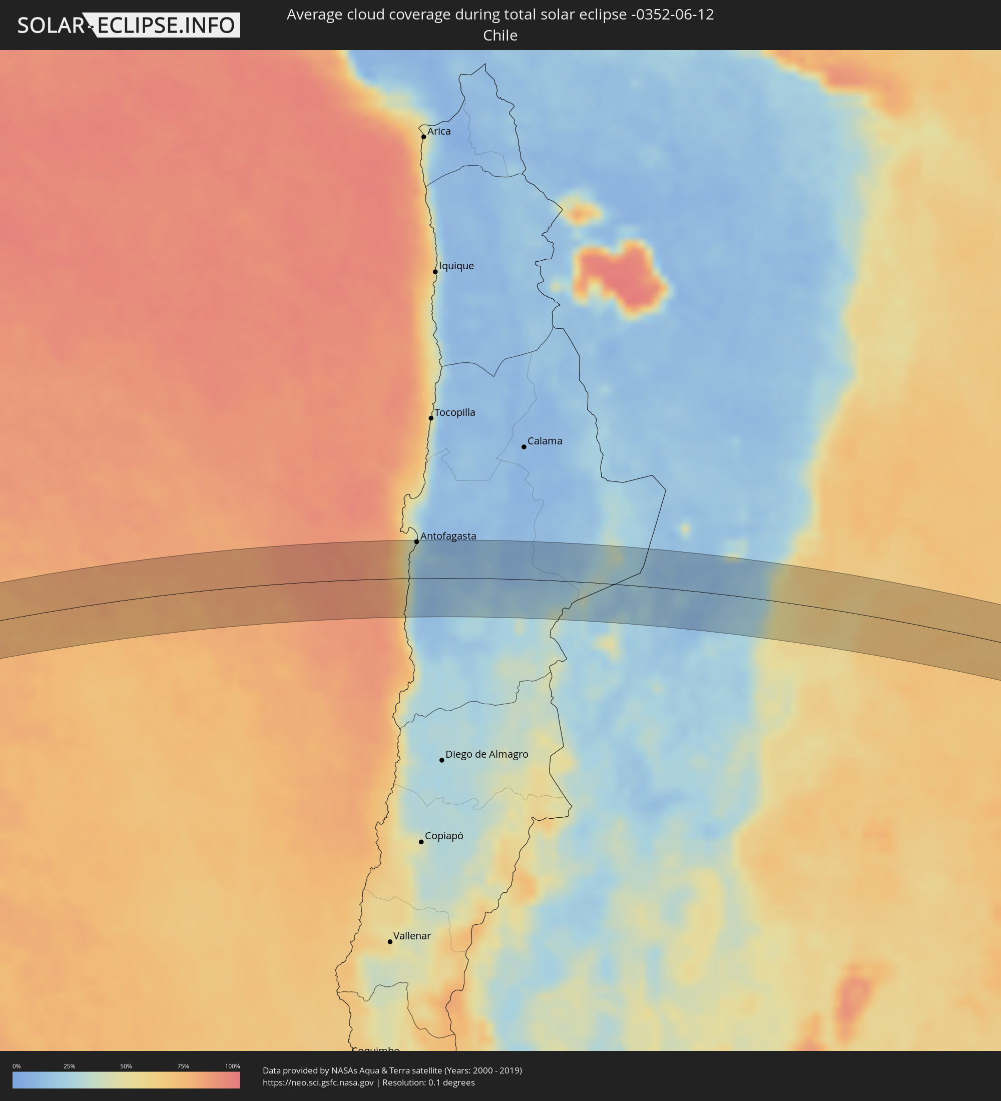 Chile
Chile
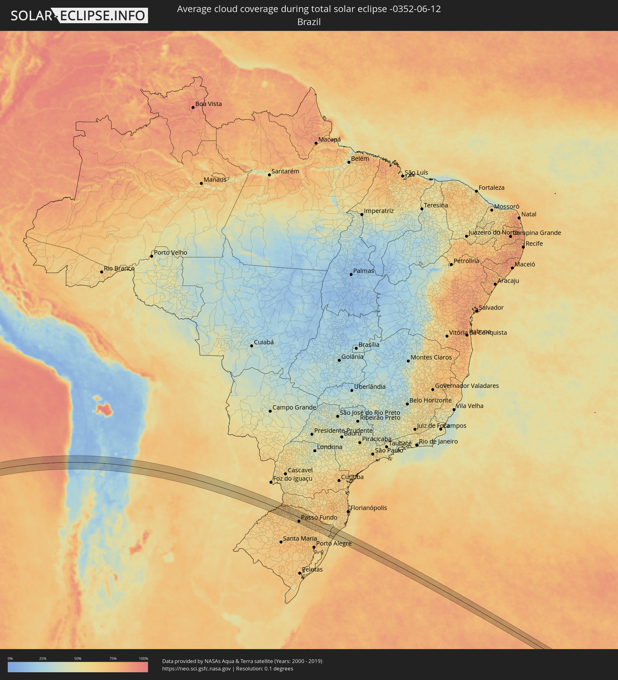 Brazil
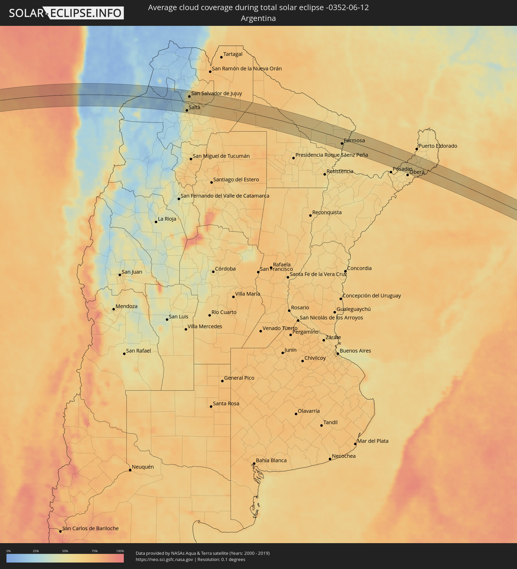 Argentina
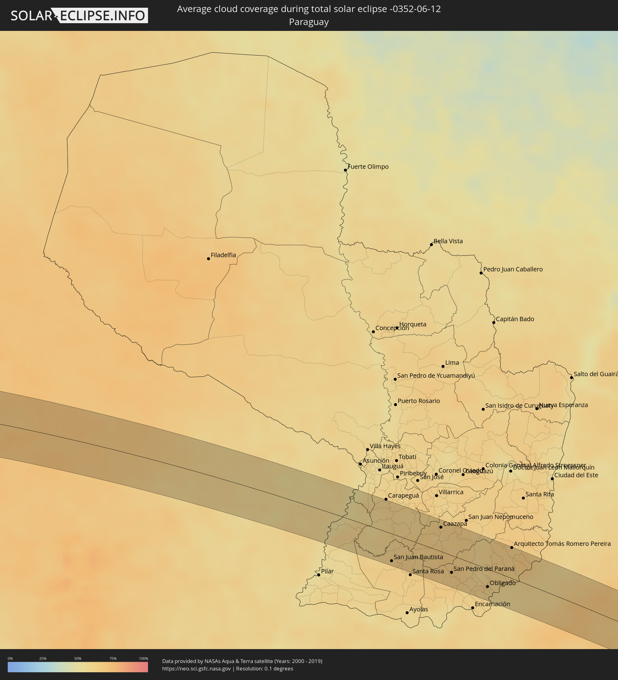 Paraguay
Cities inside the path of the eclipse
The following table shows all locations with a population of more than 5,000 inside the eclipse path. Cities which have more than 100,000 inhabitants are marked bold. A click at the locations opens a detailed map.
| City | Type | Eclipse duration | Local time of max. eclipse | Distance to central line | Ø Cloud coverage |
 Antofagasta, Antofagasta
|
total | - | 11:55:14 UTC-04:42 | 50 km | 27% |
 Salta, Salta Province
|
total | - | 12:36:08 UTC-04:16 | 43 km | 56% |
|
San Salvador de Jujuy, Jujuy Province
|
total | - | 12:36:34 UTC-04:16 | 24 km | 57% |
|
Palpalá, Jujuy Province
|
total | - | 12:36:49 UTC-04:16 | 19 km | 57% |
|
San Pedro, Jujuy Province
|
total | - | 12:37:50 UTC-04:16 | 27 km | 66% |
|
Ingenio La Esperanza, Jujuy Province
|
total | - | 12:37:55 UTC-04:16 | 28 km | 68% |
|
Las Lajitas, Salta Province
|
total | - | 12:39:34 UTC-04:16 | 13 km | 65% |
|
Apolinario Saravia, Salta Province
|
total | - | 12:40:21 UTC-04:16 | 19 km | 65% |
|
Ibarreta, Formosa Province
|
total | - | 12:51:46 UTC-04:16 | 30 km | 60% |
|
Comandante Fontana, Formosa Province
|
total | - | 12:52:12 UTC-04:16 | 22 km | 58% |
|
Palo Santo, Formosa Province
|
total | - | 12:53:04 UTC-04:16 | 8 km | 56% |
|
Pirané, Formosa Province
|
total | - | 12:53:37 UTC-04:16 | 3 km | 58% |
|
Formosa, Formosa Province
|
total | - | 12:55:54 UTC-04:16 | 22 km | 57% |
 Quiindy, Paraguarí
|
total | - | 13:24:25 UTC-03:50 | 29 km | 59% |
|
San Juan Bautista, Misiones
|
total | - | 13:24:29 UTC-03:50 | 40 km | 63% |
|
Caazapá, Caazapá
|
total | - | 13:26:34 UTC-03:50 | 35 km | 62% |
|
San Pedro del Paraná, Itapúa
|
total | - | 13:26:45 UTC-03:50 | 25 km | 64% |
|
Hohenau, Itapúa
|
total | - | 13:27:44 UTC-03:50 | 35 km | 61% |
|
Obligado, Itapúa
|
total | - | 13:28:02 UTC-03:50 | 26 km | 60% |
|
Gobernador Roca, Misiones Province
|
total | - | 13:02:15 UTC-04:16 | 36 km | 57% |
|
Santo Pipó, Misiones Province
|
total | - | 13:02:24 UTC-04:16 | 29 km | 56% |
|
Arquitecto Tomás Romero Pereira, Itapúa
|
total | - | 13:29:10 UTC-03:50 | 45 km | 64% |
|
Jardín América, Misiones Province
|
total | - | 13:02:52 UTC-04:16 | 13 km | 58% |
|
Capioví, Misiones Province
|
total | - | 13:03:18 UTC-04:16 | 5 km | 59% |
|
Campo Viera, Misiones Province
|
total | - | 13:03:11 UTC-04:16 | 41 km | 62% |
|
Puerto Rico, Misiones Province
|
total | - | 13:03:27 UTC-04:16 | 20 km | 61% |
|
Campo Grande, Misiones Province
|
total | - | 13:03:23 UTC-04:16 | 21 km | 59% |
|
Garuhapé, Misiones Province
|
total | - | 13:03:36 UTC-04:16 | 21 km | 61% |
|
Aristóbulo del Valle, Misiones Province
|
total | - | 13:03:38 UTC-04:16 | 6 km | 58% |
|
El Alcázar, Misiones Province
|
total | - | 13:03:58 UTC-04:16 | 36 km | 60% |
|
Veinticinco de Mayo, Misiones Province
|
total | - | 13:03:52 UTC-04:16 | 29 km | 67% |
|
Dos de Mayo, Misiones Province
|
total | - | 13:04:09 UTC-04:16 | 9 km | 59% |
|
Colonia Aurora, Misiones Province
|
total | - | 13:04:20 UTC-04:16 | 31 km | 71% |
 Horizontina, Rio Grande do Sul
|
total | - | 14:15:06 UTC-03:06 | 39 km | 68% |
|
El Soberbio, Misiones Province
|
total | - | 13:05:10 UTC-04:16 | 1 km | 70% |
|
Três Passos, Rio Grande do Sul
|
total | - | 14:16:02 UTC-03:06 | 7 km | 65% |
|
Santo Augusto, Rio Grande do Sul
|
total | - | 14:16:13 UTC-03:06 | 42 km | 66% |
|
Frederico Westphalen, Rio Grande do Sul
|
total | - | 14:17:18 UTC-03:06 | 23 km | 65% |
|
Palmeira das Missões, Rio Grande do Sul
|
total | - | 14:17:14 UTC-03:06 | 29 km | 68% |
|
Sarandi, Rio Grande do Sul
|
total | - | 14:18:05 UTC-03:06 | 18 km | 64% |
|
Passo Fundo, Rio Grande do Sul
|
total | - | 14:19:03 UTC-03:06 | 31 km | 66% |
|
Erechim, Rio Grande do Sul
|
total | - | 14:19:38 UTC-03:06 | 39 km | 65% |
|
Marau, Rio Grande do Sul
|
total | - | 14:19:24 UTC-03:06 | 41 km | 67% |
|
Tapejara, Rio Grande do Sul
|
total | - | 14:19:59 UTC-03:06 | 5 km | 69% |
|
Sananduva, Rio Grande do Sul
|
total | - | 14:20:29 UTC-03:06 | 25 km | 69% |
|
Lagoa Vermelha, Rio Grande do Sul
|
total | - | 14:20:57 UTC-03:06 | 10 km | 68% |
|
Vacaria, Rio Grande do Sul
|
total | - | 14:22:02 UTC-03:06 | 4 km | 68% |
|
Torres, Rio Grande do Sul
|
total | - | 14:24:02 UTC-03:06 | 29 km | 60% |
|
Sombrio, Santa Catarina
|
total | - | 14:24:22 UTC-03:06 | 2 km | 61% |
|
Araranguá, Santa Catarina
|
total | - | 14:24:42 UTC-03:06 | 21 km | 66% |
|
Forquilhinha, Santa Catarina
|
total | - | 14:24:51 UTC-03:06 | 40 km | 66% |