Total solar eclipse of 01/28/-0383
| Day of week: | Thursday |
| Maximum duration of eclipse: | 03m49s |
| Maximum width of eclipse path: | 274 km |
| Saros cycle: | 44 |
| Coverage: | 100% |
| Magnitude: | 1.0456 |
| Gamma: | 0.832 |
Wo kann man die Sonnenfinsternis vom 01/28/-0383 sehen?
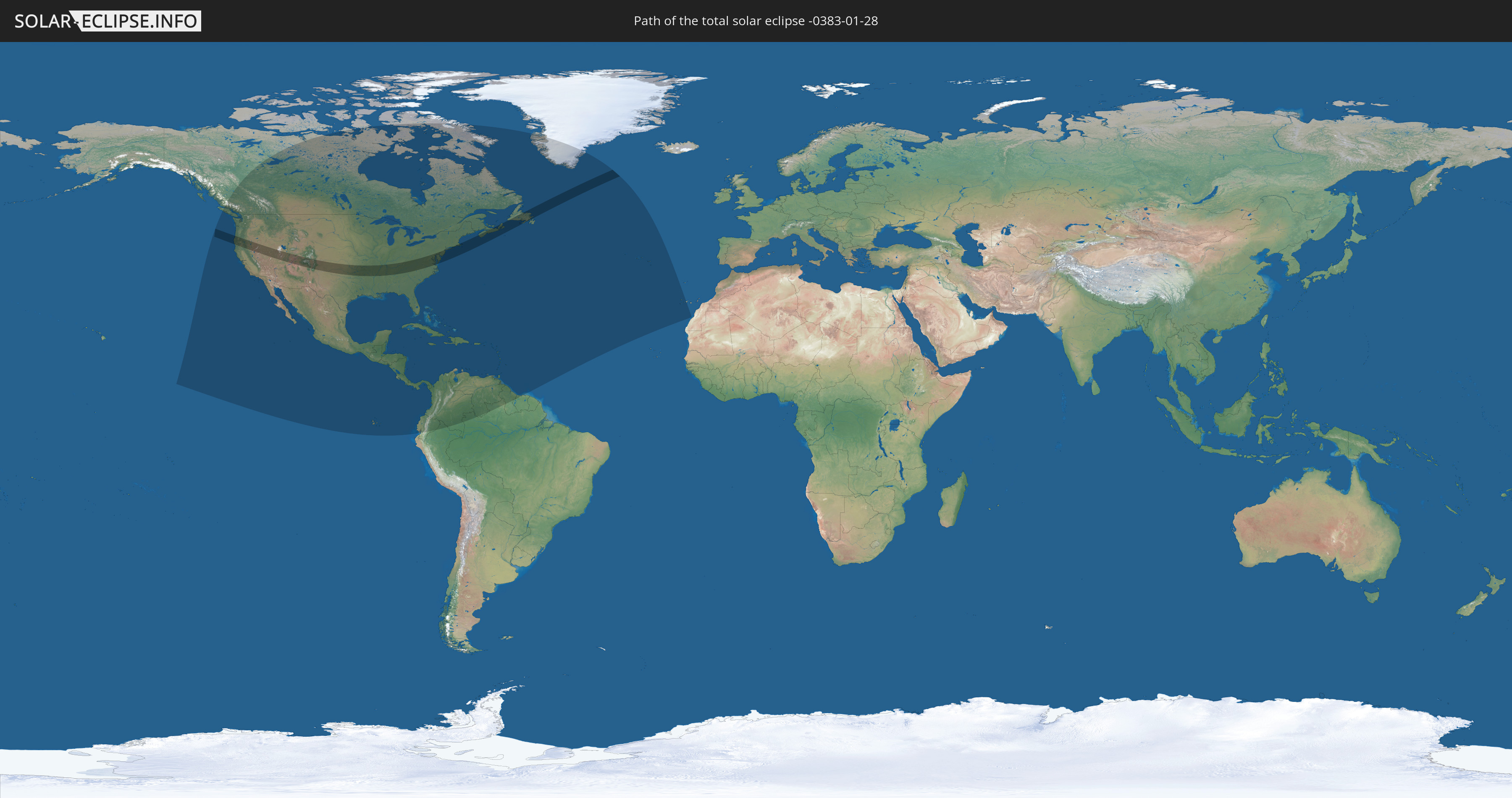
Die Sonnenfinsternis am 01/28/-0383 kann man in 48 Ländern als partielle Sonnenfinsternis beobachten.
Der Finsternispfad verläuft durch 3 Länder. Nur in diesen Ländern ist sie als total Sonnenfinsternis zu sehen.
In den folgenden Ländern ist die Sonnenfinsternis total zu sehen
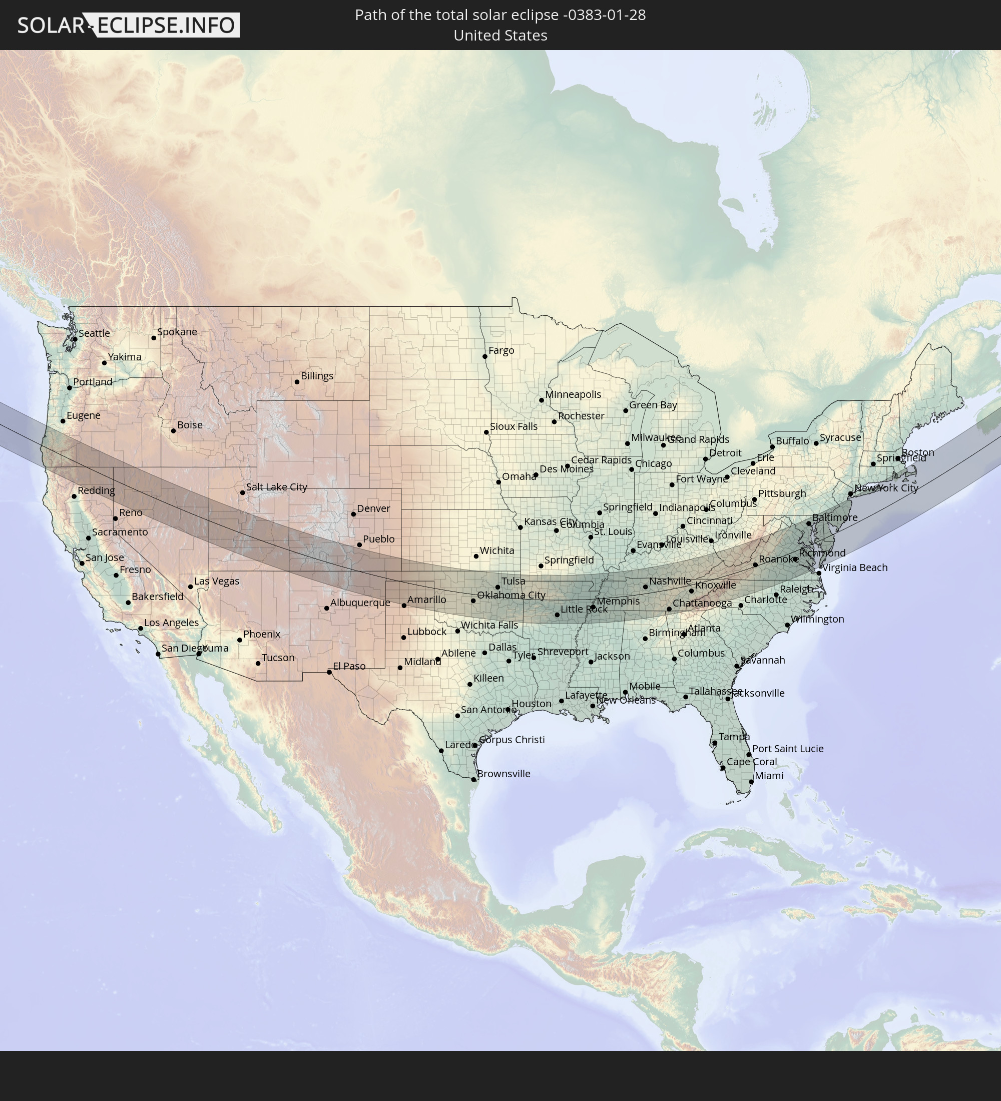 United States
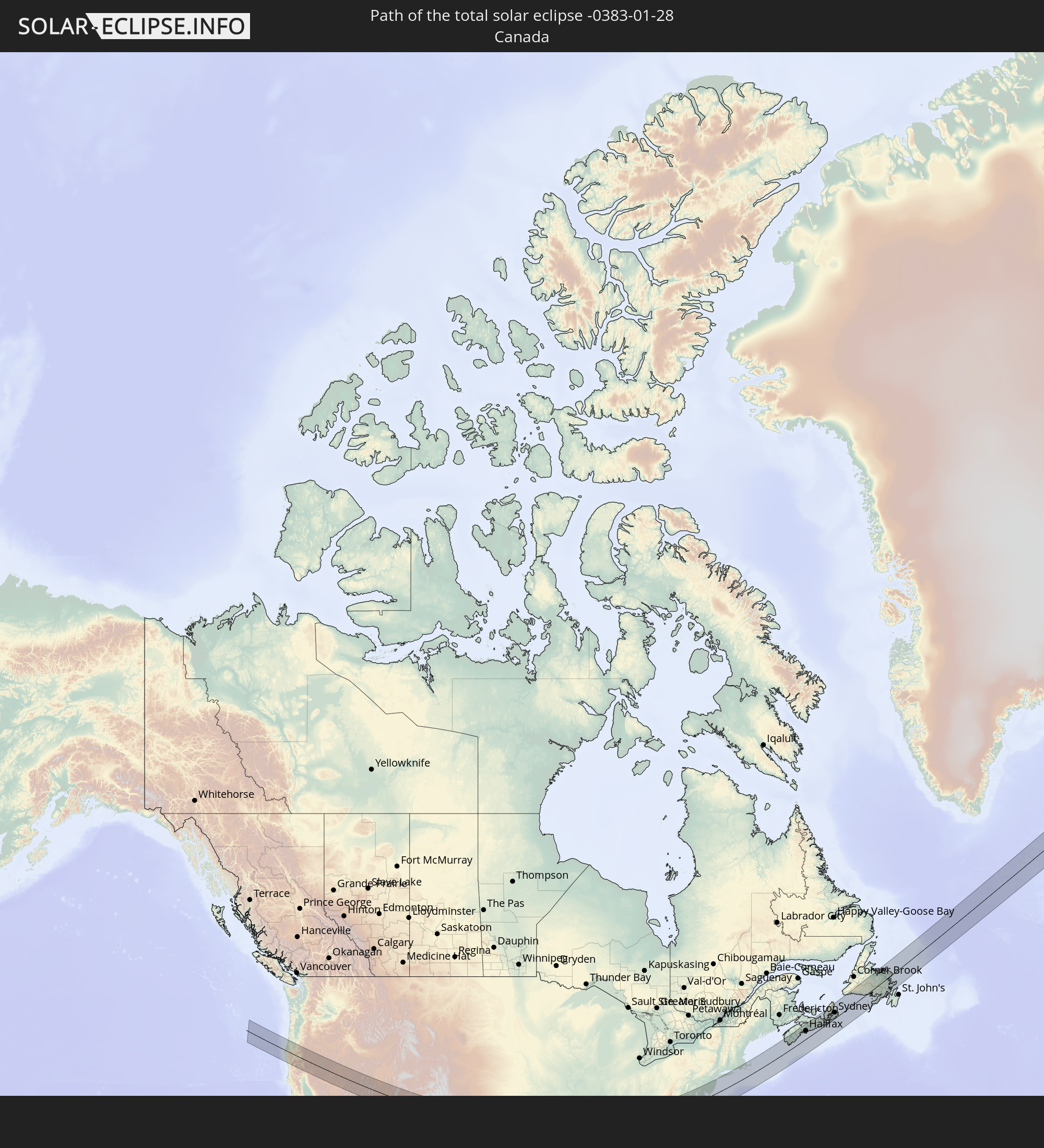 Canada
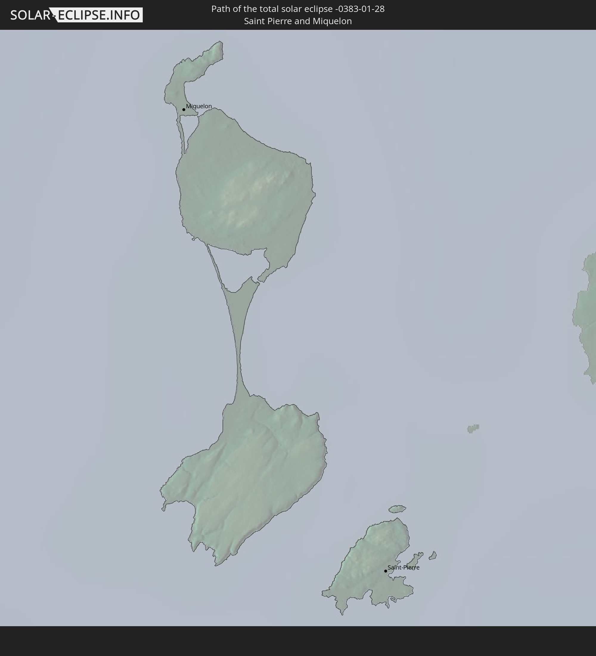 Saint Pierre and Miquelon
In den folgenden Ländern ist die Sonnenfinsternis partiell zu sehen
 United States
 United States Minor Outlying Islands
 Canada
 Mexico
 Greenland
 Guatemala
 Ecuador
 El Salvador
 Honduras
 Belize
 Nicaragua
 Costa Rica
 Cuba
Cuba
 Panama
 Colombia
 Cayman Islands
 Peru
Peru
 The Bahamas
 Jamaica
 Haiti
Haiti
 Brazil
 Venezuela
 Turks and Caicos Islands
 Dominican Republic
 Aruba
Aruba
 Puerto Rico
 United States Virgin Islands
 Bermuda
 British Virgin Islands
 Anguilla
 Collectivity of Saint Martin
 Saint Barthélemy
 Saint Kitts and Nevis
 Antigua and Barbuda
 Montserrat
 Trinidad and Tobago
 Guadeloupe
 Grenada
 Dominica
 Saint Vincent and the Grenadines
 Guyana
 Martinique
 Saint Lucia
 Barbados
 Suriname
 Saint Pierre and Miquelon
 Portugal
 Spain
Spain
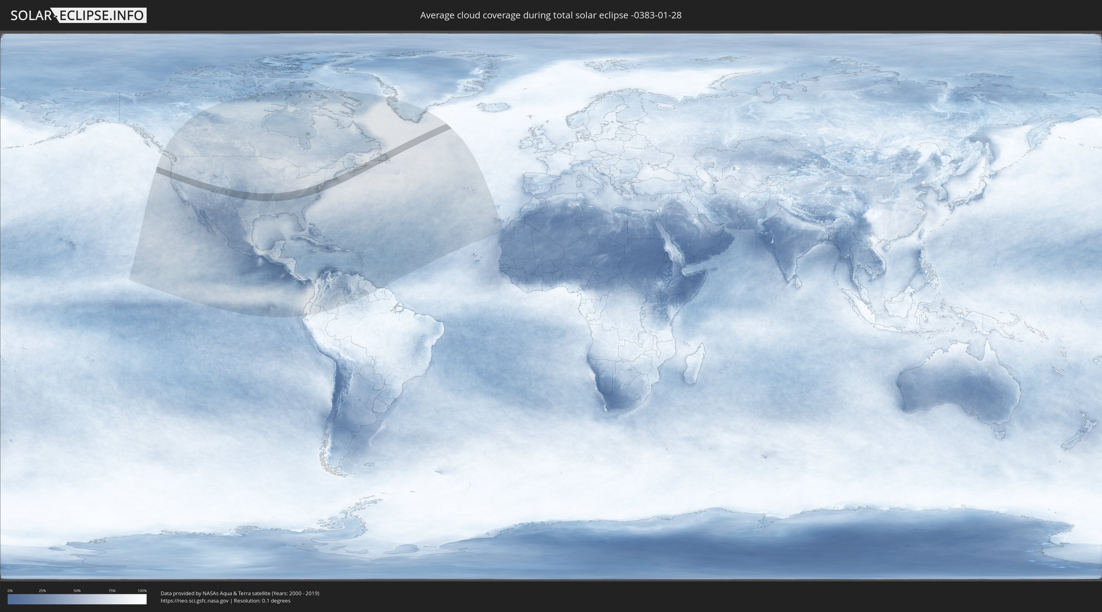
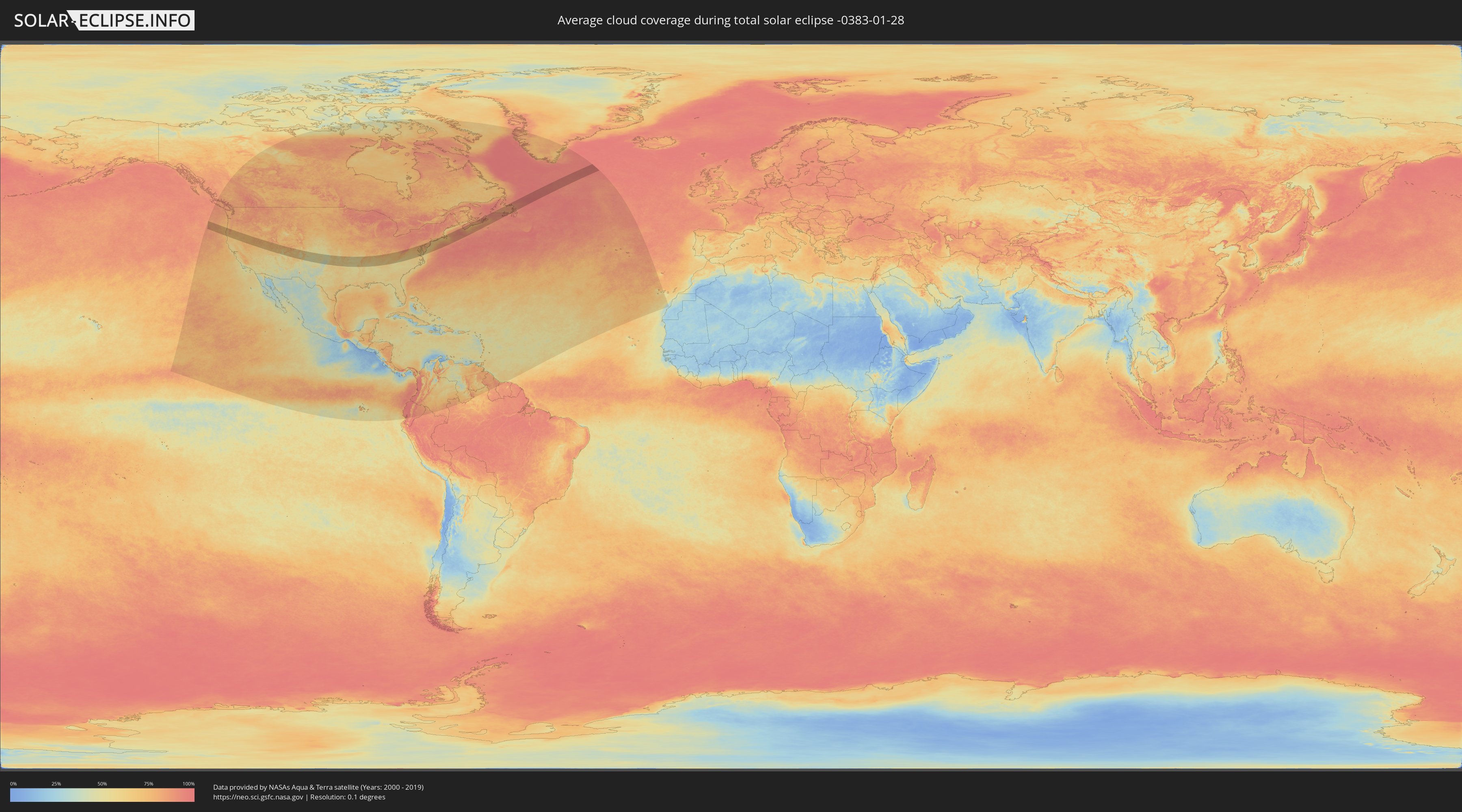
How will be the weather during the total solar eclipse on 01/28/-0383?
Where is the best place to see the total solar eclipse of 01/28/-0383?
The following maps show the average cloud coverage for the day of the total solar eclipse.
With the help of these maps, it is possible to find the place along the eclipse path, which has the best
chance of a cloudless sky.
Nevertheless, you should consider local circumstances and inform about the weather of your chosen
observation site.
The data is provided by NASAs satellites
AQUA and TERRA.
The cloud maps are averaged over a period of 19 years (2000 - 2019).
Detailed country maps
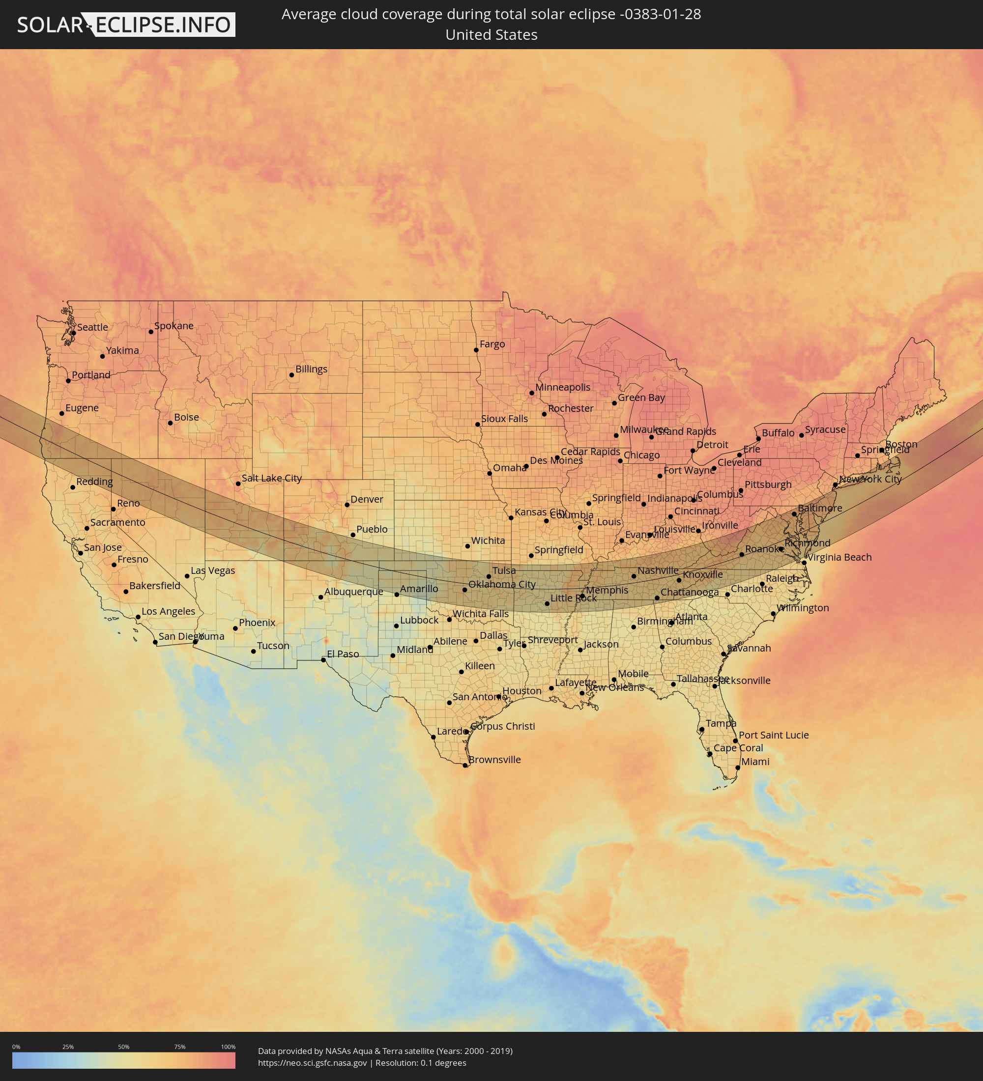 United States
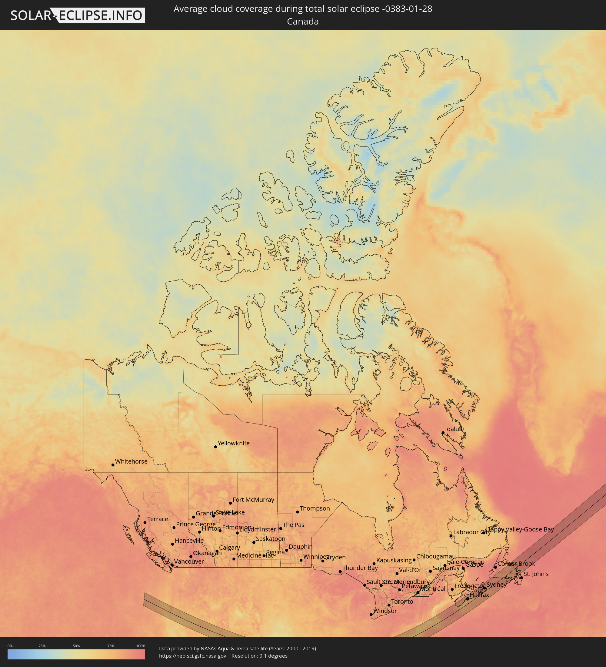 Canada
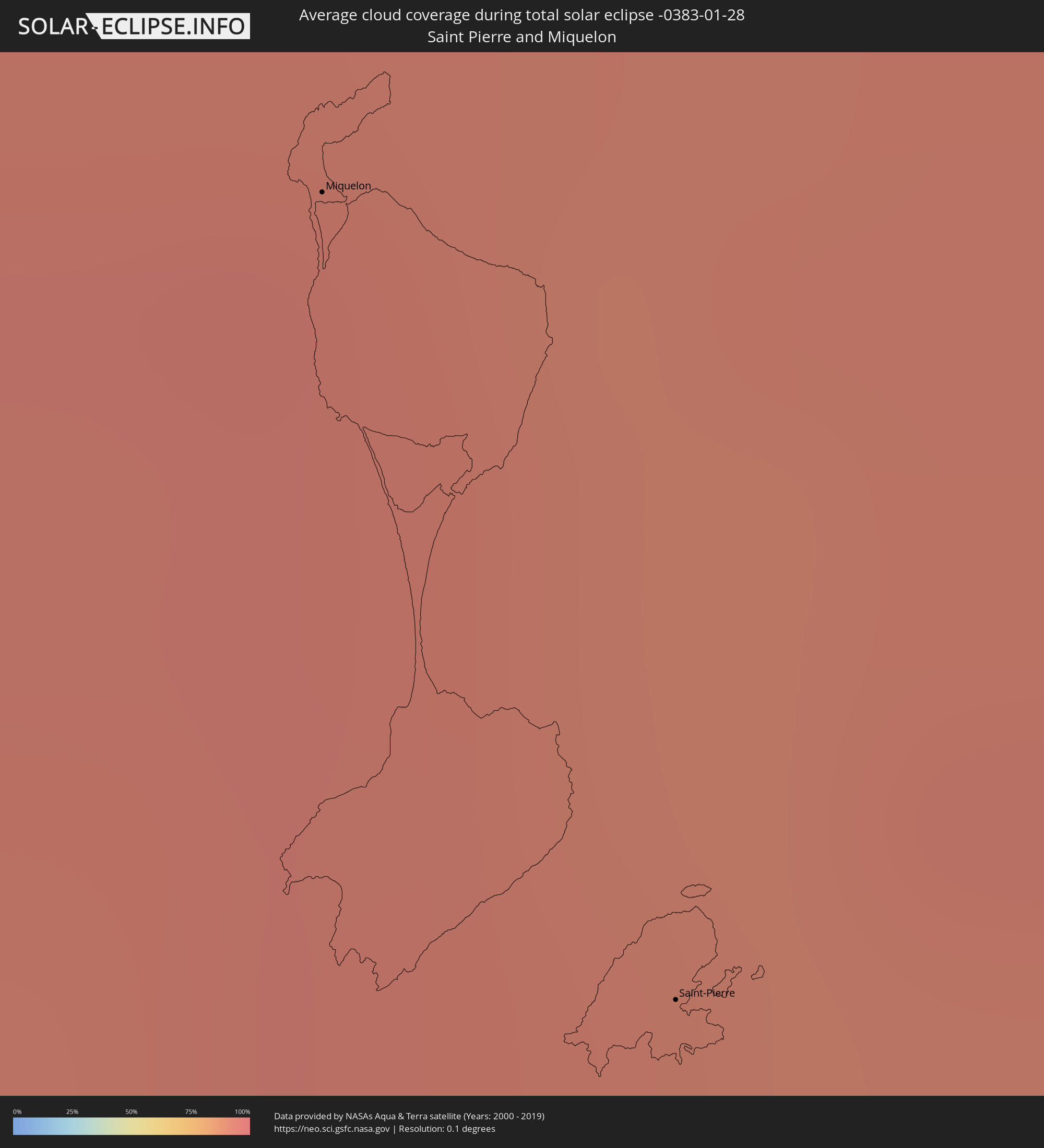 Saint Pierre and Miquelon
Cities inside the path of the eclipse
The following table shows all locations with a population of more than 5,000 inside the eclipse path. Cities which have more than 100,000 inhabitants are marked bold. A click at the locations opens a detailed map.
| City | Type | Eclipse duration | Local time of max. eclipse | Distance to central line | Ø Cloud coverage |
|
Medford, Oregon
|
total | - | 08:15:31 UTC-08:00 | 10 km | 74% |
|
Enid, Oklahoma
|
total | - | 10:39:41 UTC-06:00 | 59 km | 62% |
|
Oklahoma City, Oklahoma
|
total | - | 10:39:26 UTC-06:00 | 39 km | 63% |
|
Edmond, Oklahoma
|
total | - | 10:39:41 UTC-06:00 | 19 km | 60% |
|
Norman, Oklahoma
|
total | - | 10:39:20 UTC-06:00 | 66 km | 61% |
|
Stillwater, Oklahoma
|
total | - | 10:40:55 UTC-06:00 | 37 km | 59% |
|
Tulsa, Oklahoma
|
total | - | 10:42:57 UTC-06:00 | 52 km | 60% |
|
Broken Arrow, Oklahoma
|
total | - | 10:43:14 UTC-06:00 | 42 km | 64% |
|
Fort Smith, Arkansas
|
total | - | 10:45:19 UTC-06:00 | 23 km | 62% |
|
Fayetteville, Arkansas
|
total | - | 10:46:25 UTC-06:00 | 54 km | 62% |
|
Rogers, Arkansas
|
total | - | 10:46:44 UTC-06:00 | 84 km | 61% |
|
Conway, Arkansas
|
total | - | 10:48:59 UTC-06:00 | 51 km | 55% |
|
Little Rock, Arkansas
|
total | - | 10:49:00 UTC-06:00 | 89 km | 52% |
|
Jonesboro, Arkansas
|
total | - | 10:53:13 UTC-06:00 | 31 km | 73% |
|
Memphis, Tennessee
|
total | - | 10:54:02 UTC-06:00 | 49 km | 58% |
|
Southaven, Mississippi
|
total | - | 10:53:58 UTC-06:00 | 67 km | 58% |
|
Bartlett, Tennessee
|
total | - | 10:54:26 UTC-06:00 | 44 km | 55% |
|
Collierville, Tennessee
|
total | - | 10:54:45 UTC-06:00 | 64 km | 57% |
|
Jackson, Tennessee
|
total | - | 10:57:01 UTC-06:00 | 6 km | 62% |
|
Clarksville, Tennessee
|
total | - | 11:00:49 UTC-06:00 | 80 km | 66% |
|
Decatur, Alabama
|
total | - | 11:00:15 UTC-06:00 | 137 km | 59% |
|
Franklin, Tennessee
|
total | - | 11:01:27 UTC-06:00 | 7 km | 66% |
|
Nashville, Tennessee
|
total | - | 11:01:48 UTC-06:00 | 33 km | 65% |
|
Hendersonville, Tennessee
|
total | - | 11:02:15 UTC-06:00 | 46 km | 66% |
|
Huntsville, Alabama
|
total | - | 11:01:12 UTC-06:00 | 128 km | 60% |
|
Bowling Green, Kentucky
|
total | - | 11:03:07 UTC-06:00 | 118 km | 75% |
|
Murfreesboro, Tennessee
|
total | - | 11:02:26 UTC-06:00 | 8 km | 65% |
|
Chattanooga, Tennessee
|
total | - | 12:04:15 UTC-05:00 | 113 km | 59% |
|
Knoxville, Tennessee
|
total | - | 12:07:55 UTC-05:00 | 38 km | 64% |
|
Kingsport, Tennessee
|
total | - | 12:11:16 UTC-05:00 | 4 km | 72% |
|
Asheville, North Carolina
|
total | - | 12:10:44 UTC-05:00 | 107 km | 58% |
|
Johnson City, Tennessee
|
total | - | 12:11:35 UTC-05:00 | 35 km | 70% |
|
Winston-Salem, North Carolina
|
total | - | 12:16:08 UTC-05:00 | 112 km | 59% |
|
High Point, North Carolina
|
total | - | 12:16:36 UTC-05:00 | 134 km | 58% |
|
Roanoke, Virginia
|
total | - | 12:17:22 UTC-05:00 | 3 km | 67% |
|
Greensboro, North Carolina
|
total | - | 12:17:07 UTC-05:00 | 127 km | 59% |
|
Danville, Virginia
|
total | - | 12:18:14 UTC-05:00 | 85 km | 64% |
|
Lynchburg, Virginia
|
total | - | 12:19:09 UTC-05:00 | 6 km | 64% |
|
Harrisonburg, Virginia
|
total | - | 12:20:11 UTC-05:00 | 94 km | 73% |
|
Charlottesville, Virginia
|
total | - | 12:20:51 UTC-05:00 | 37 km | 66% |
|
Ashburn, Virginia
|
total | - | 12:23:19 UTC-05:00 | 109 km | 79% |
|
Richmond, Virginia
|
total | - | 12:22:50 UTC-05:00 | 45 km | 67% |
|
Centreville, Virginia
|
total | - | 12:23:22 UTC-05:00 | 86 km | 72% |
|
Reston, Virginia
|
total | - | 12:23:35 UTC-05:00 | 96 km | 78% |
|
Dale City, Virginia
|
total | - | 12:23:32 UTC-05:00 | 61 km | 73% |
|
Germantown, Maryland
|
total | - | 12:23:48 UTC-05:00 | 115 km | 79% |
|
Aspen Hill, Maryland
|
total | - | 12:24:11 UTC-05:00 | 98 km | 76% |
|
Washington, D.C., Washington, D.C.
|
total | - | 12:24:12 UTC-05:00 | 78 km | 75% |
|
Waldorf, Maryland
|
total | - | 12:24:19 UTC-05:00 | 47 km | 76% |
|
Columbia, Maryland
|
total | - | 12:24:44 UTC-05:00 | 106 km | 80% |
|
Bowie, Maryland
|
total | - | 12:24:52 UTC-05:00 | 72 km | 76% |
|
Severn, Maryland
|
total | - | 12:24:59 UTC-05:00 | 91 km | 77% |
|
Baltimore, Maryland
|
total | - | 12:25:13 UTC-05:00 | 103 km | 78% |
|
Newport News, Virginia
|
total | - | 12:24:48 UTC-05:00 | 127 km | 61% |
|
South Bel Air, Maryland
|
total | - | 12:25:51 UTC-05:00 | 118 km | 80% |
|
Wilmington, Delaware
|
total | - | 12:27:32 UTC-05:00 | 110 km | 80% |
|
Philadelphia, Pennsylvania
|
total | - | 12:28:22 UTC-05:00 | 116 km | 82% |
|
Vineland, New Jersey
|
total | - | 12:28:32 UTC-05:00 | 65 km | 77% |
|
Jackson, New Jersey
|
total | - | 12:28:56 UTC-05:00 | 87 km | 78% |
|
Trenton, New Jersey
|
total | - | 12:29:16 UTC-05:00 | 127 km | 79% |
|
Lakewood, New Jersey
|
total | - | 12:30:18 UTC-05:00 | 94 km | 80% |
|
Toms River, New Jersey
|
total | - | 12:30:19 UTC-05:00 | 79 km | 80% |
|
Levittown, New York
|
total | - | 12:31:49 UTC-05:00 | 128 km | 74% |
|
Brentwood, New York
|
total | - | 12:32:21 UTC-05:00 | 123 km | 79% |
|
Fall River, Massachusetts
|
total | - | 12:36:29 UTC-05:00 | 125 km | 77% |
|
New Bedford, Massachusetts
|
total | - | 12:36:53 UTC-05:00 | 110 km | 75% |
|
Barnstable, Massachusetts
|
total | - | 12:38:05 UTC-05:00 | 89 km | 76% |
|
Yarmouth, Nova Scotia
|
total | - | 13:30:58 UTC-04:14 | 104 km | 86% |
|
Bridgewater, Nova Scotia
|
total | - | 13:33:30 UTC-04:14 | 81 km | 81% |
|
Lower Sacvkille, Nova Scotia
|
total | - | 13:34:45 UTC-04:14 | 79 km | 84% |
|
Dartmouth, Nova Scotia
|
total | - | 13:34:57 UTC-04:14 | 65 km | 82% |
|
Halifax, Nova Scotia
|
total | - | 13:34:58 UTC-04:14 | 62 km | 80% |
|
Cole Harbour, Nova Scotia
|
total | - | 13:35:07 UTC-04:14 | 60 km | 82% |
|
Truro, Nova Scotia
|
total | - | 13:35:14 UTC-04:14 | 113 km | 82% |
|
New Glasgow, Nova Scotia
|
total | - | 13:36:07 UTC-04:14 | 105 km | 86% |
|
Antigonish, Nova Scotia
|
total | - | 13:37:06 UTC-04:14 | 78 km | 87% |
|
Princeville, Nova Scotia
|
total | - | 13:38:06 UTC-04:14 | 59 km | 90% |
|
Sydney Mines, Nova Scotia
|
total | - | 13:39:31 UTC-04:14 | 51 km | 90% |
|
Sydney, Nova Scotia
|
total | - | 13:39:36 UTC-04:14 | 41 km | 90% |
|
Glace Bay, Nova Scotia
|
total | - | 13:39:54 UTC-04:14 | 36 km | 86% |
|
Miquelon, Miquelon-Langlade
|
total | - | 14:14:08 UTC-03:44 | 48 km | 94% |
|
Saint-Pierre, Saint-Pierre
|
total | - | 14:14:34 UTC-03:44 | 86 km | 92% |
|
Grand Falls-Windsor, Newfoundland and Labrador
|
total | - | 14:27:47 UTC-03:30 | 81 km | 84% |