Total solar eclipse of 07/11/-0512
| Day of week: | Monday |
| Maximum duration of eclipse: | 06m21s |
| Maximum width of eclipse path: | 232 km |
| Saros cycle: | 57 |
| Coverage: | 100% |
| Magnitude: | 1.0714 |
| Gamma: | 0.032 |
Wo kann man die Sonnenfinsternis vom 07/11/-0512 sehen?
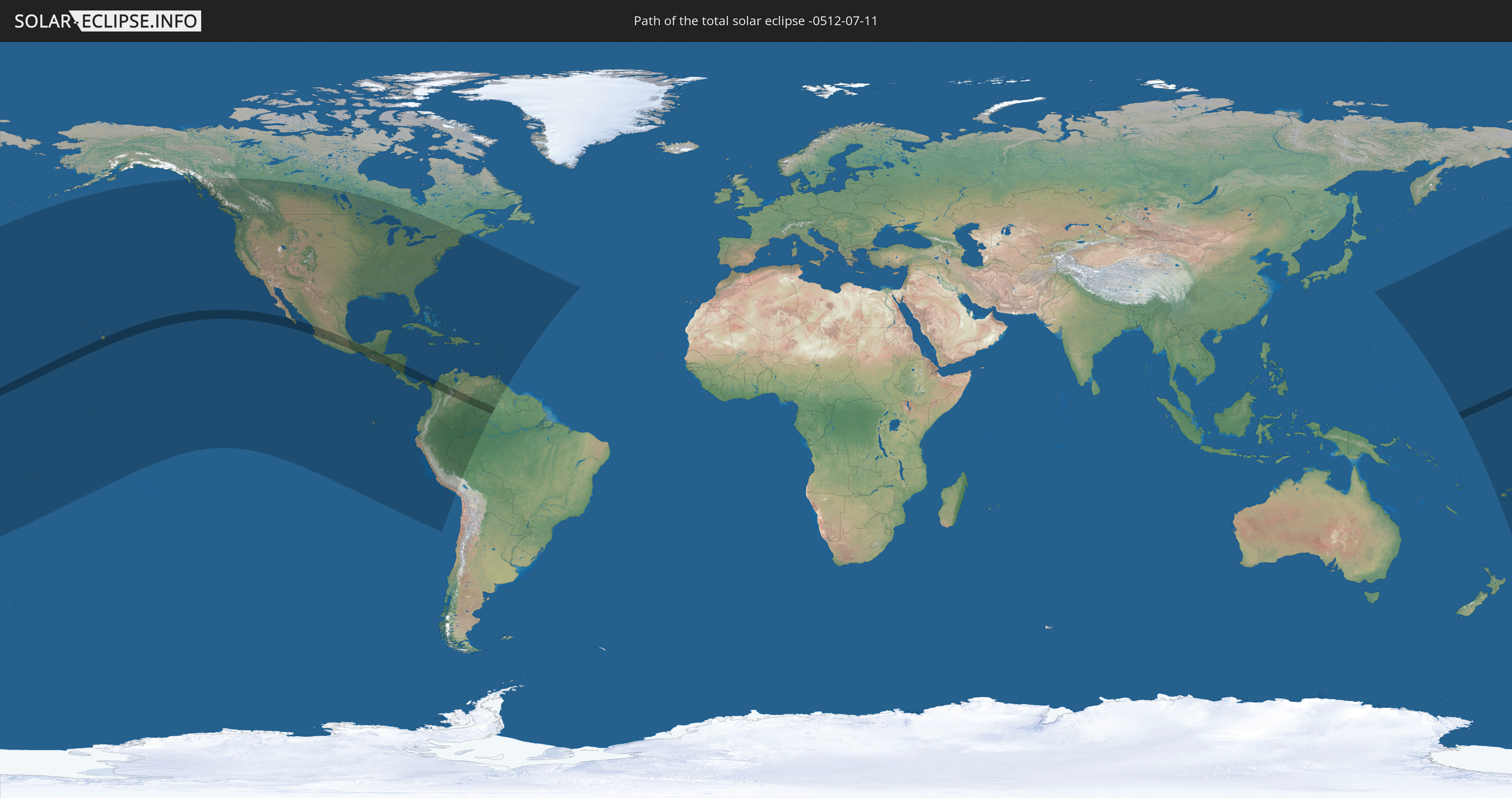
Die Sonnenfinsternis am 07/11/-0512 kann man in 57 Ländern als partielle Sonnenfinsternis beobachten.
Der Finsternispfad verläuft durch 11 Länder. Nur in diesen Ländern ist sie als total Sonnenfinsternis zu sehen.
In den folgenden Ländern ist die Sonnenfinsternis total zu sehen
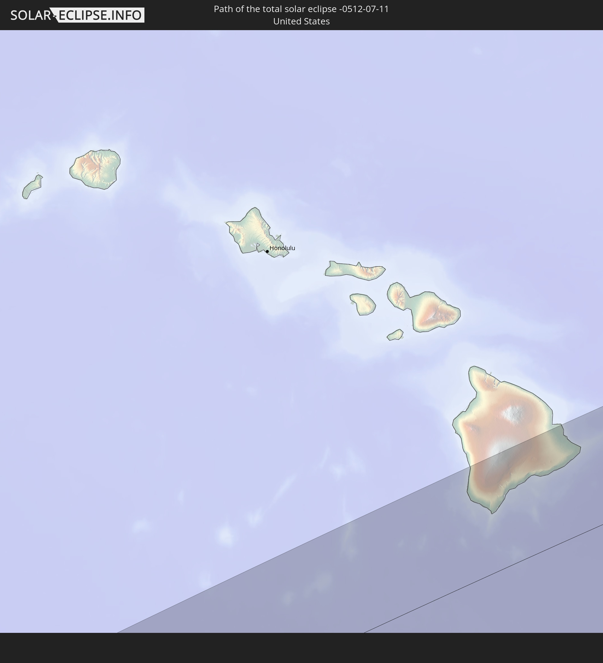 United States
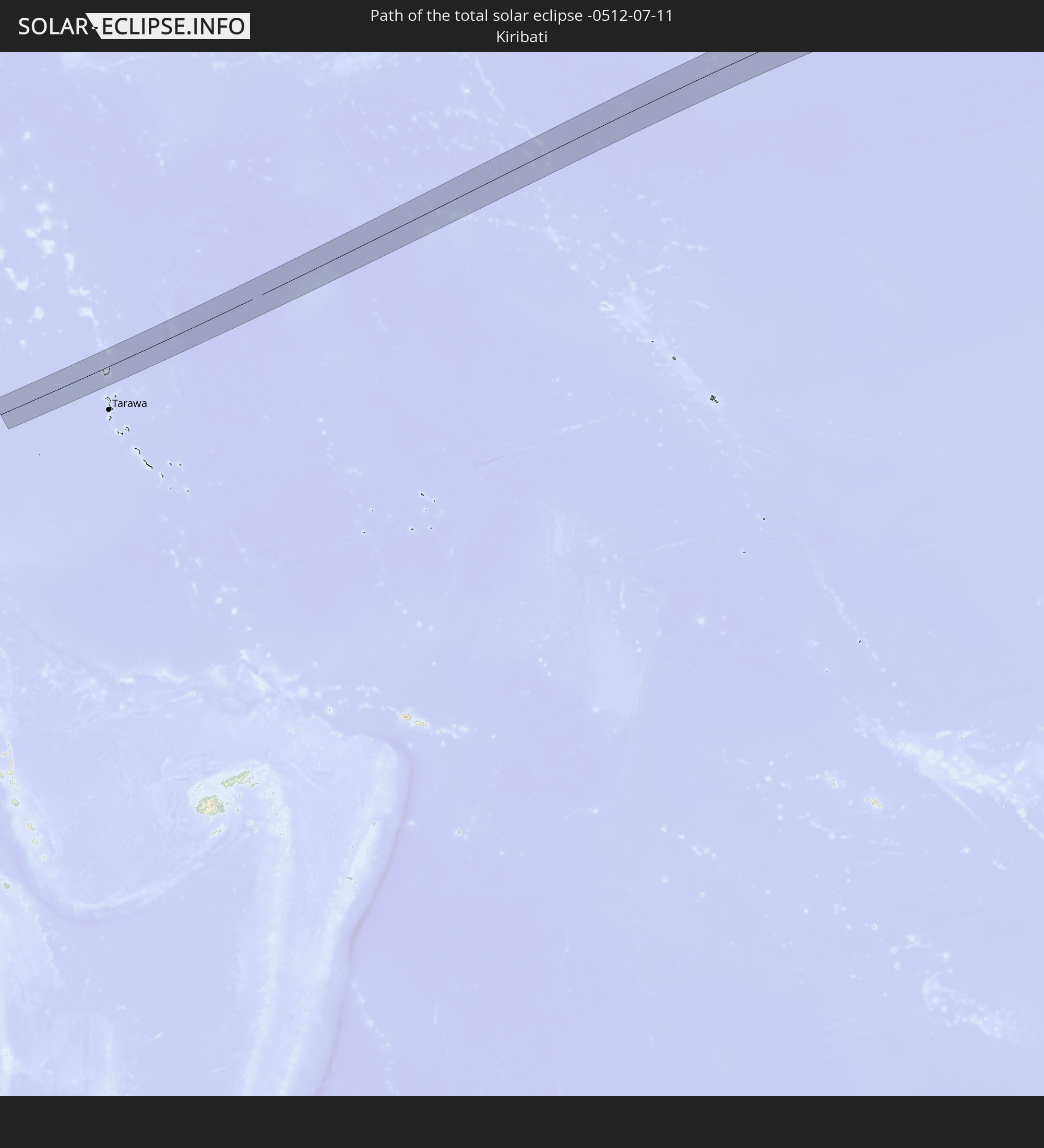 Kiribati
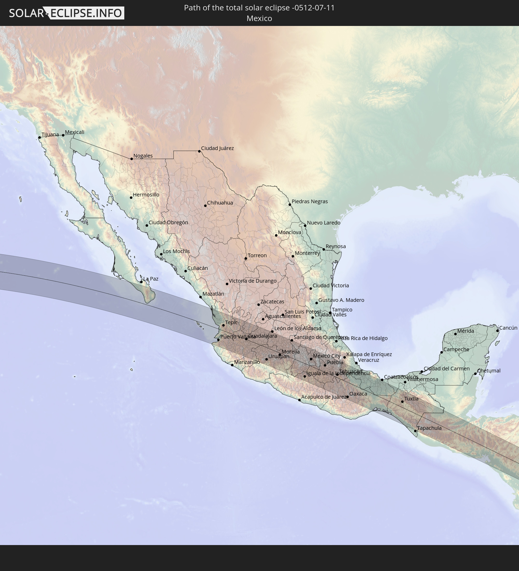 Mexico
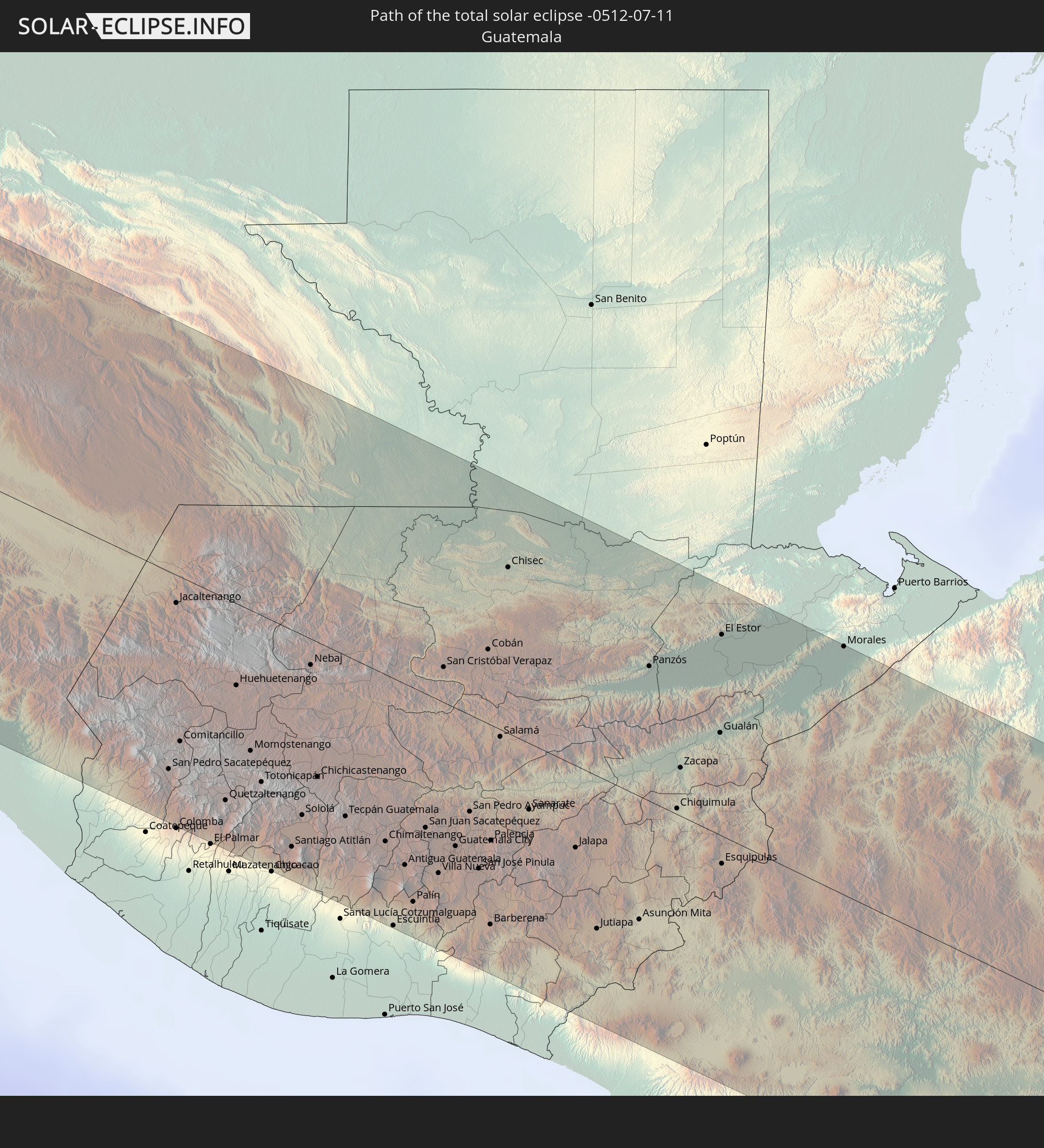 Guatemala
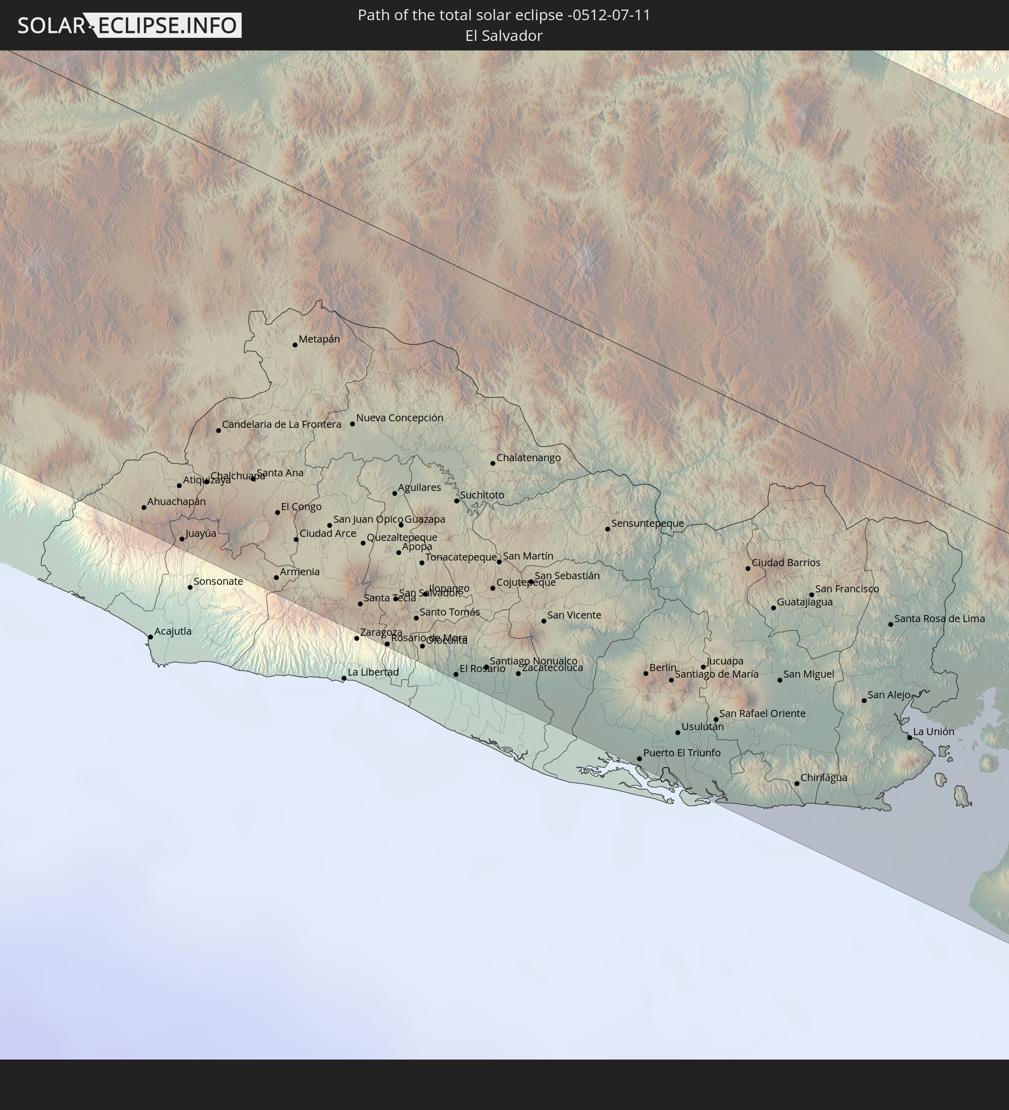 El Salvador
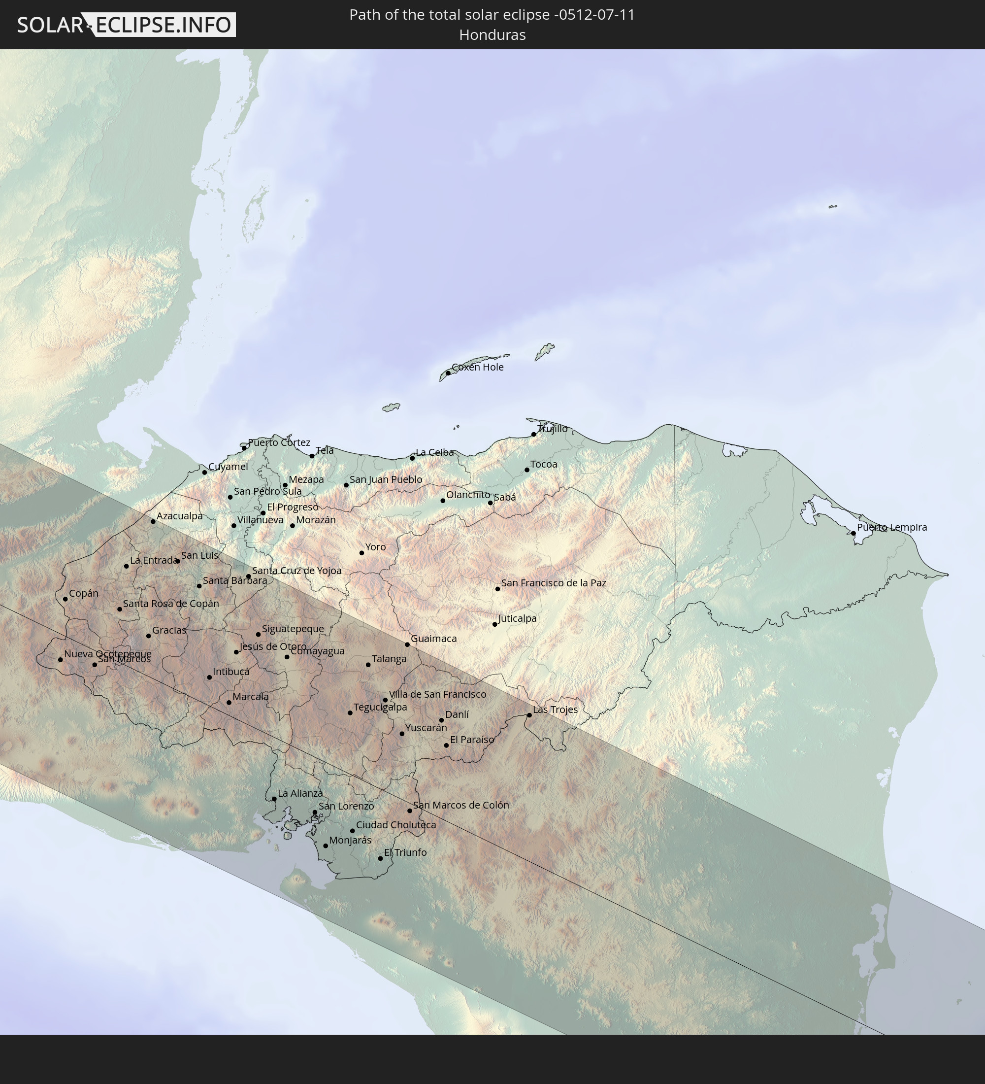 Honduras
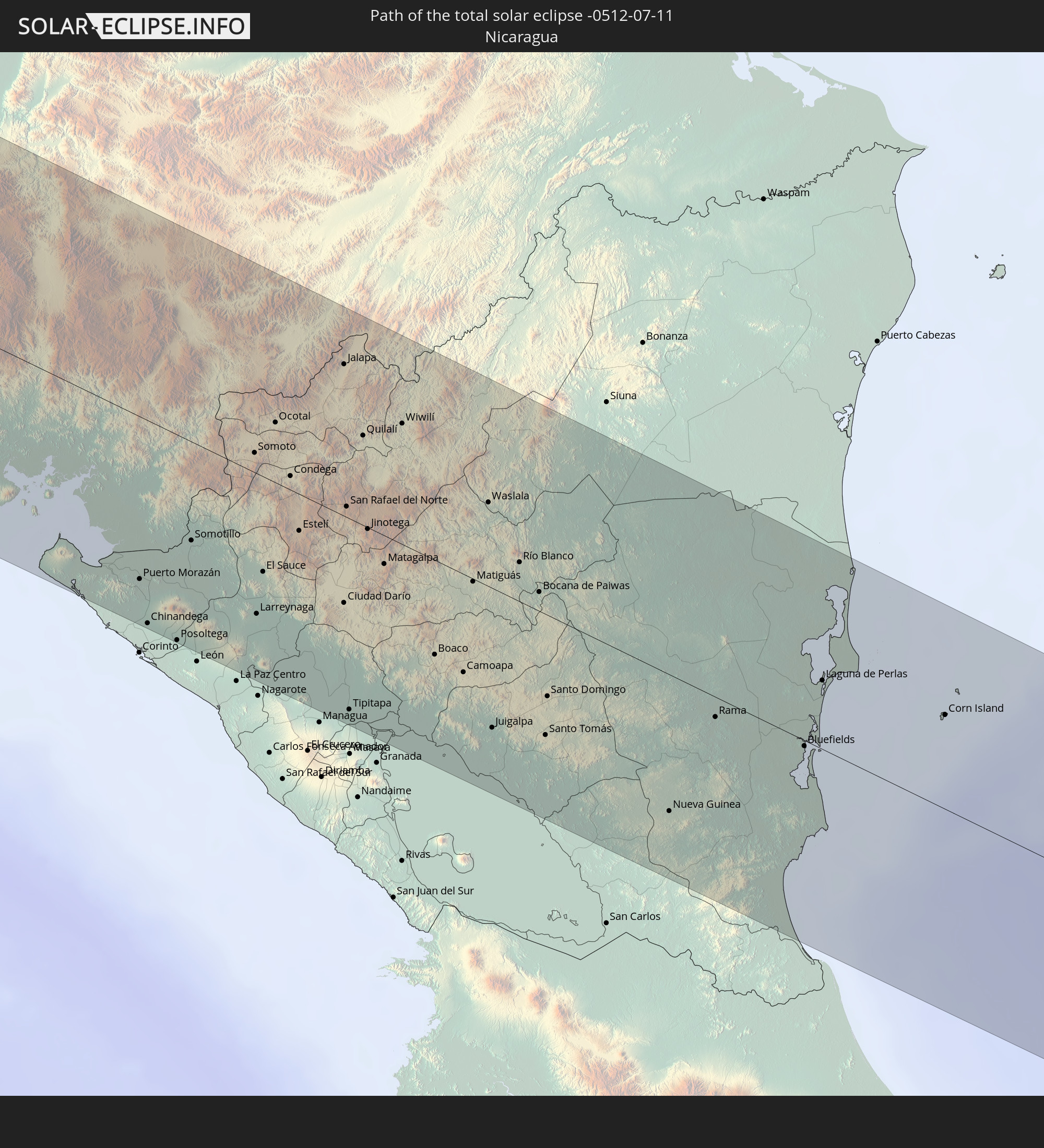 Nicaragua
 Panama
 Colombia
 Brazil
 Venezuela
In den folgenden Ländern ist die Sonnenfinsternis partiell zu sehen
 Fiji
Fiji
 United States
 United States Minor Outlying Islands
 Wallis and Futuna
 Tonga
Tonga
 Kiribati
 Samoa
Samoa
 Tokelau
 American Samoa
 Niue
Niue
 Cook Islands
 French Polynesia
 Canada
 Mexico
 Guatemala
 Ecuador
 El Salvador
 Honduras
 Belize
 Nicaragua
 Costa Rica
 Cuba
Cuba
 Panama
 Colombia
 Cayman Islands
 Peru
Peru
 The Bahamas
 Jamaica
 Haiti
Haiti
 Brazil
 Venezuela
 Turks and Caicos Islands
 Dominican Republic
 Aruba
Aruba
 Bolivia
 Puerto Rico
 United States Virgin Islands
 Bermuda
 British Virgin Islands
 Anguilla
 Collectivity of Saint Martin
 Saint Barthélemy
 Saint Kitts and Nevis
 Antigua and Barbuda
 Montserrat
 Trinidad and Tobago
 Guadeloupe
 Grenada
 Dominica
 Saint Vincent and the Grenadines
 Guyana
 Martinique
 Saint Lucia
 Barbados
 Japan
Japan
 Marshall Islands
 Tuvalu
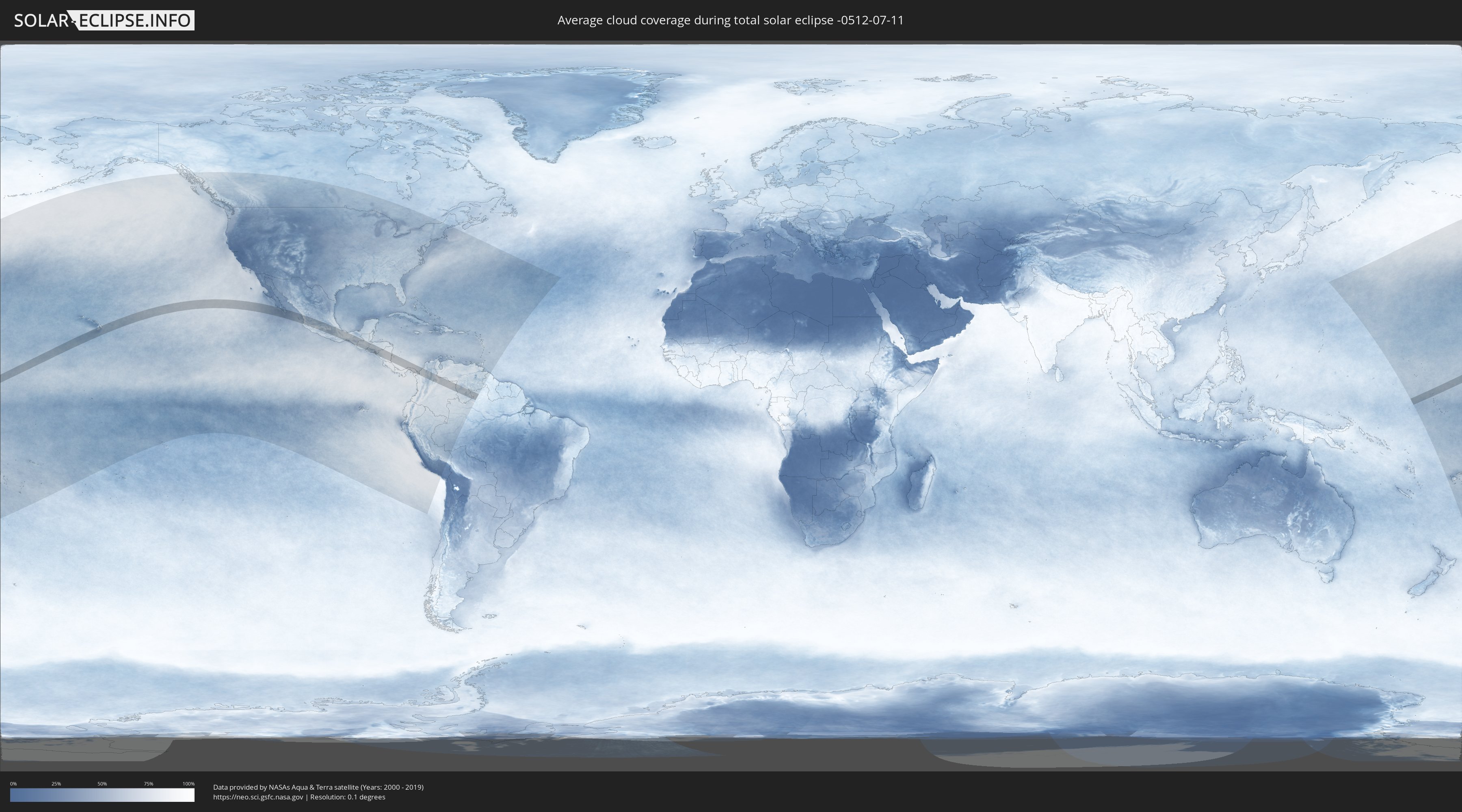
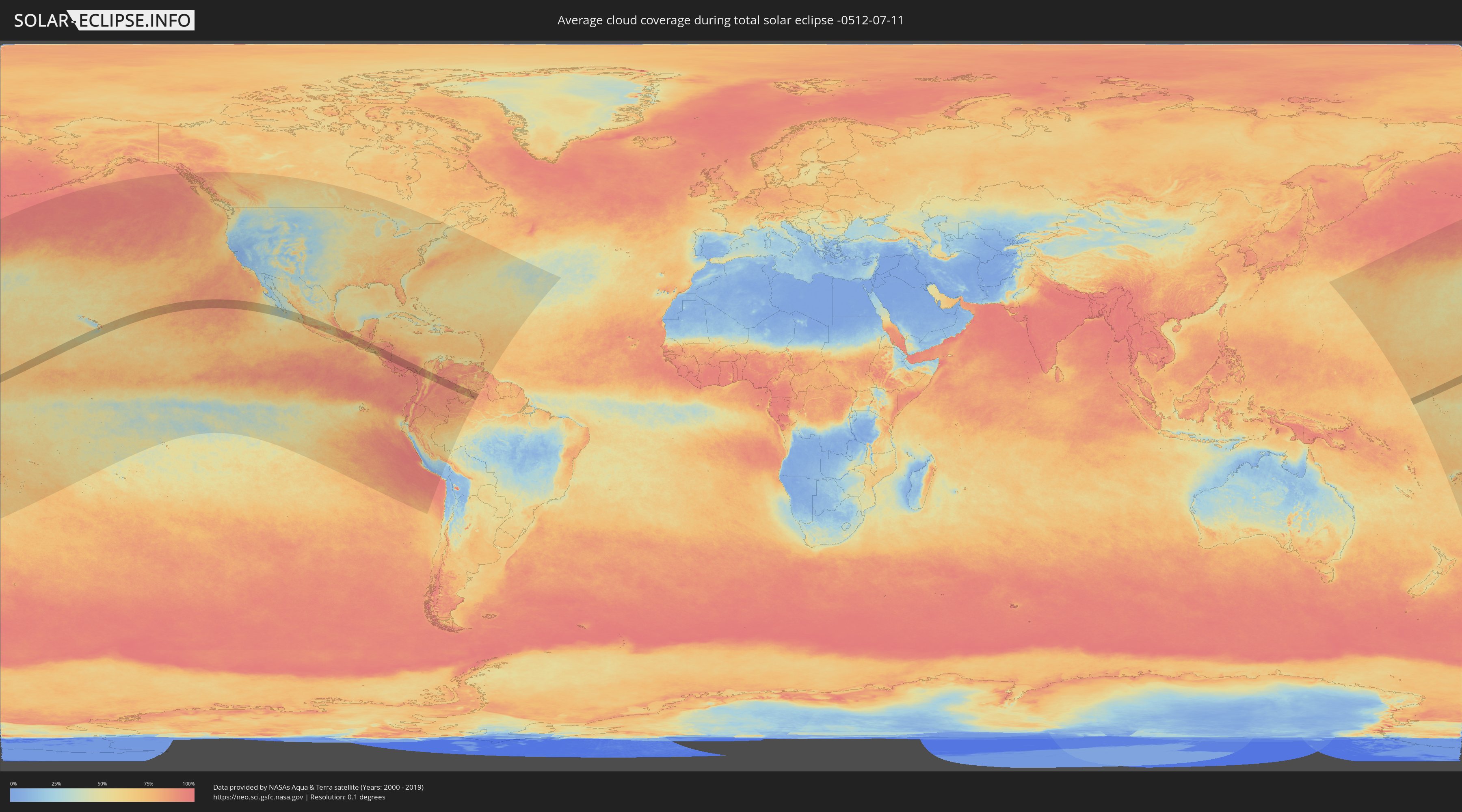
How will be the weather during the total solar eclipse on 07/11/-0512?
Where is the best place to see the total solar eclipse of 07/11/-0512?
The following maps show the average cloud coverage for the day of the total solar eclipse.
With the help of these maps, it is possible to find the place along the eclipse path, which has the best
chance of a cloudless sky.
Nevertheless, you should consider local circumstances and inform about the weather of your chosen
observation site.
The data is provided by NASAs satellites
AQUA and TERRA.
The cloud maps are averaged over a period of 19 years (2000 - 2019).
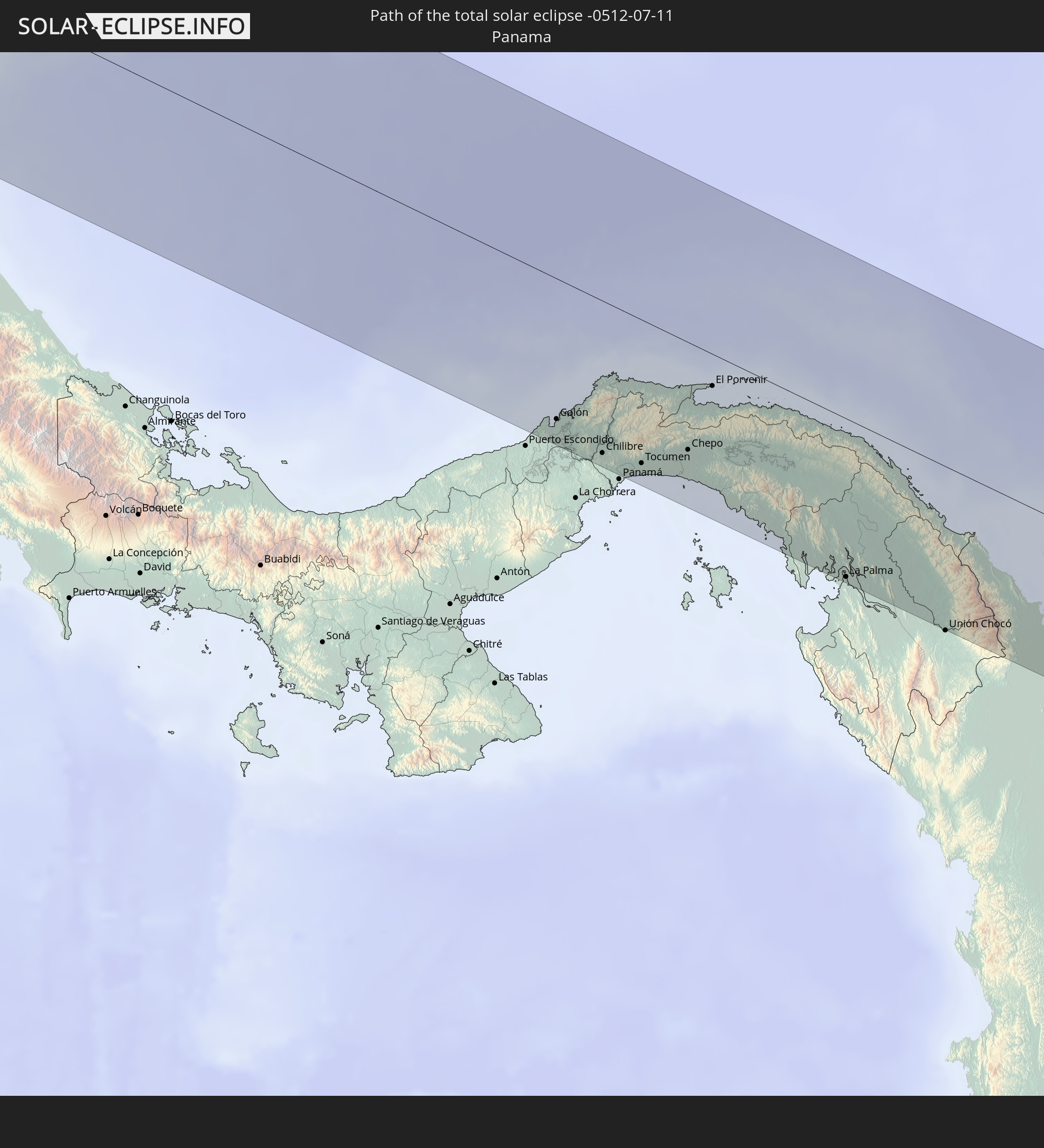
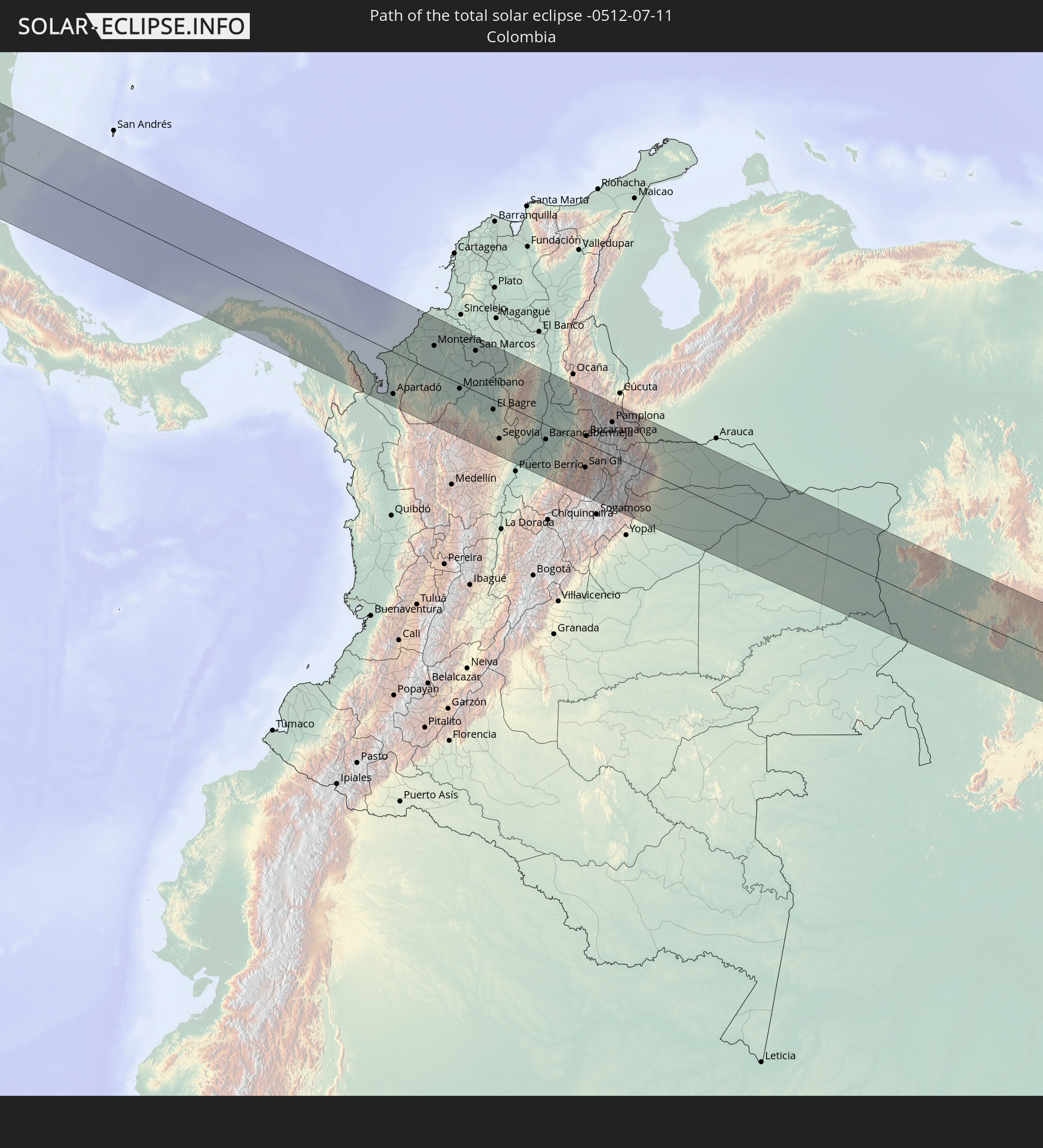
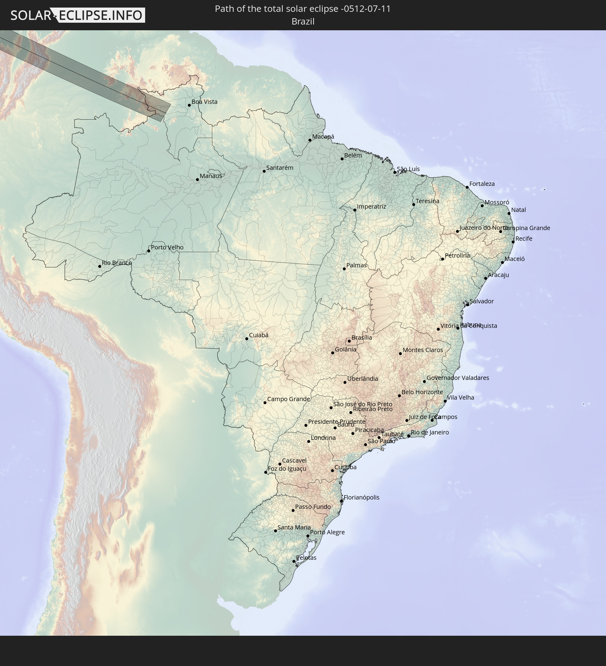
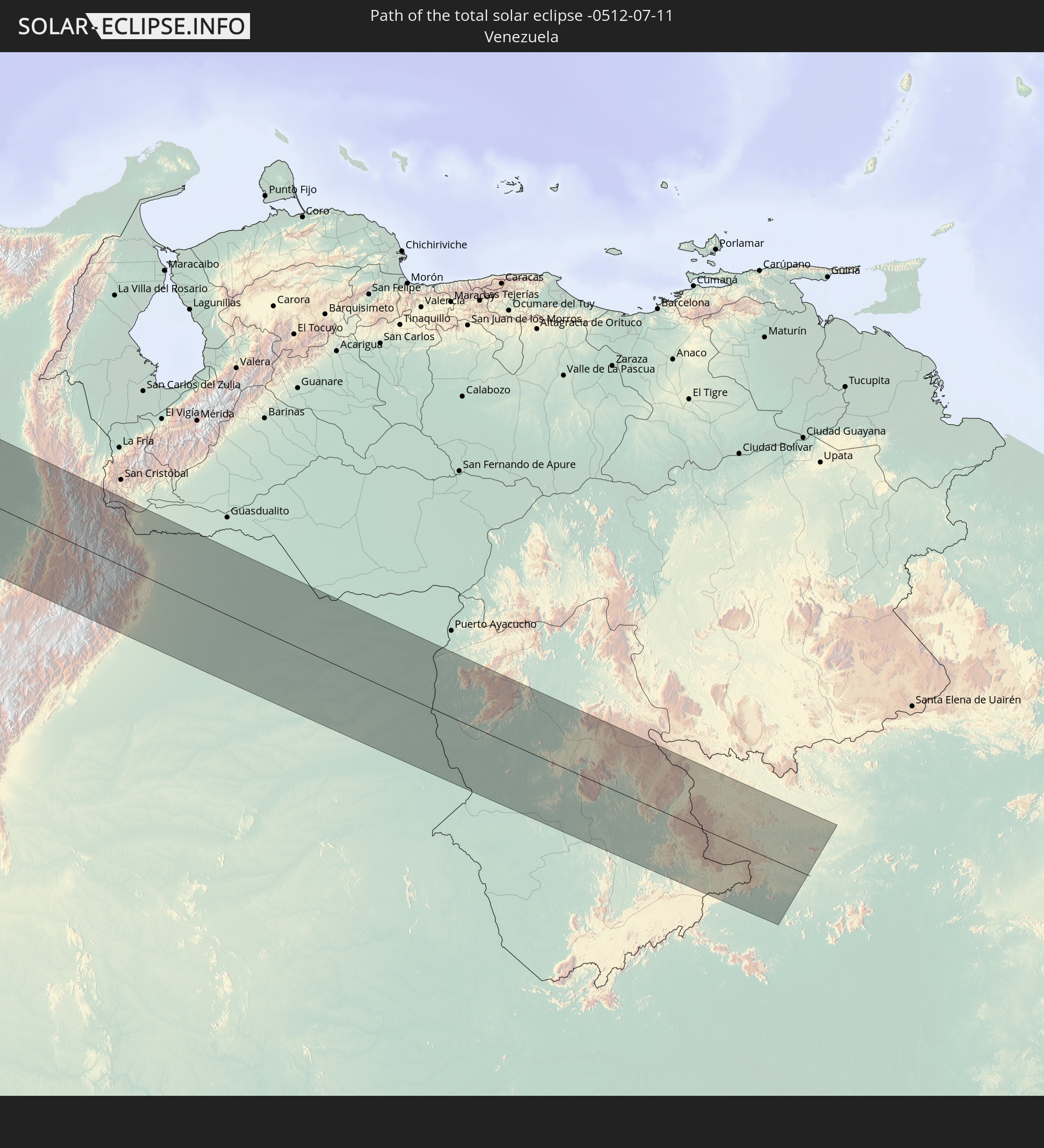
Detailed country maps
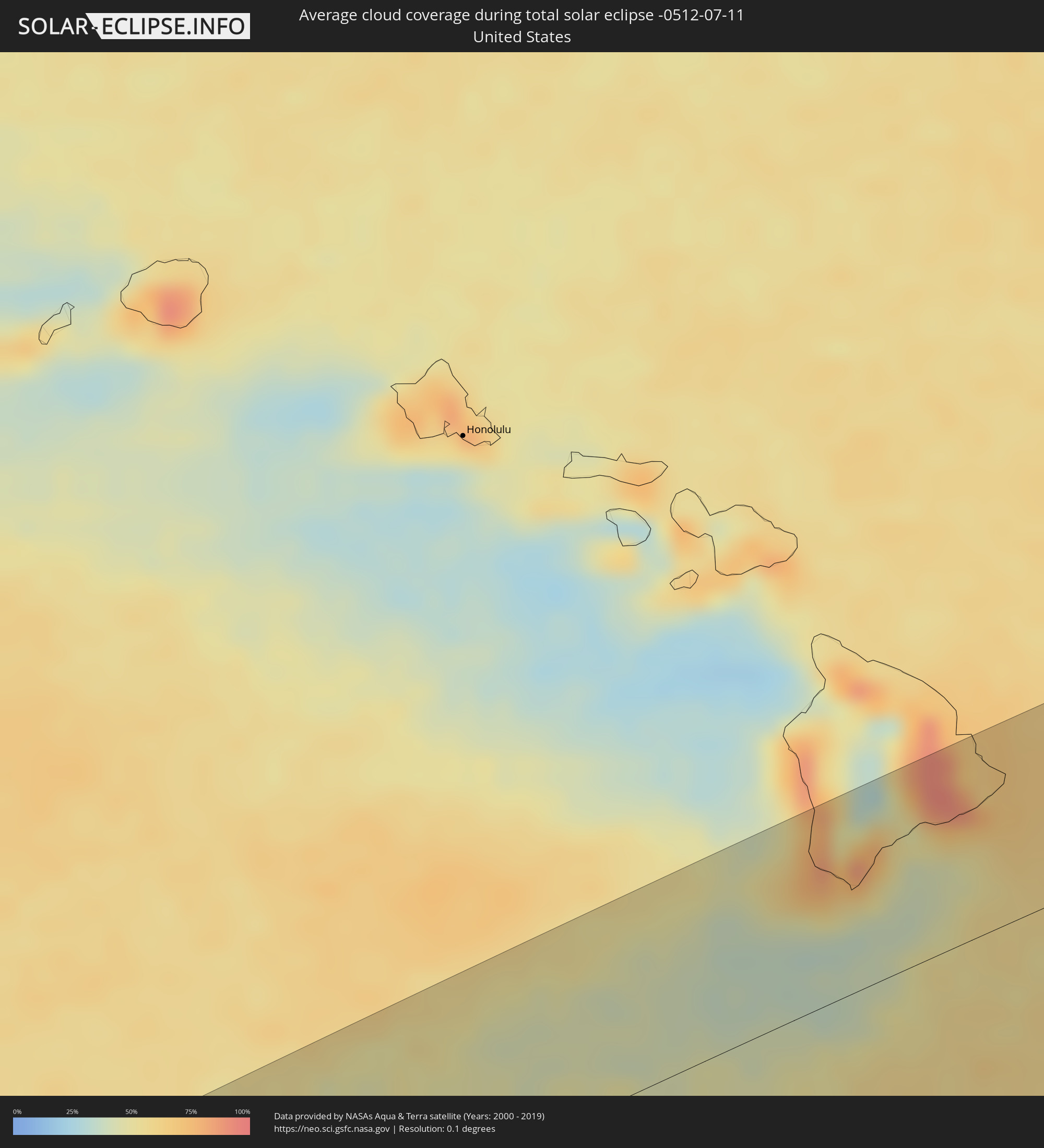 United States
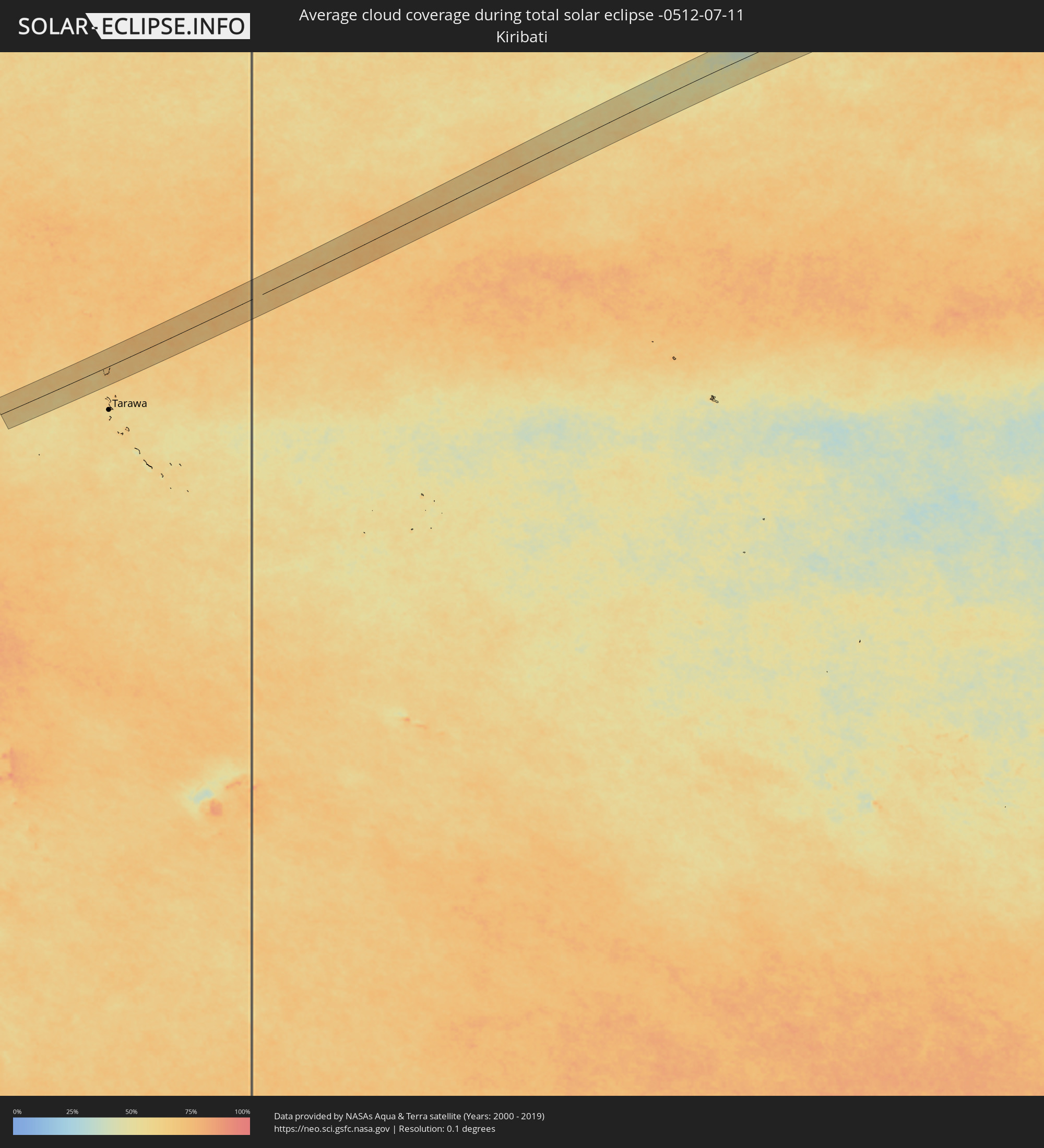 Kiribati
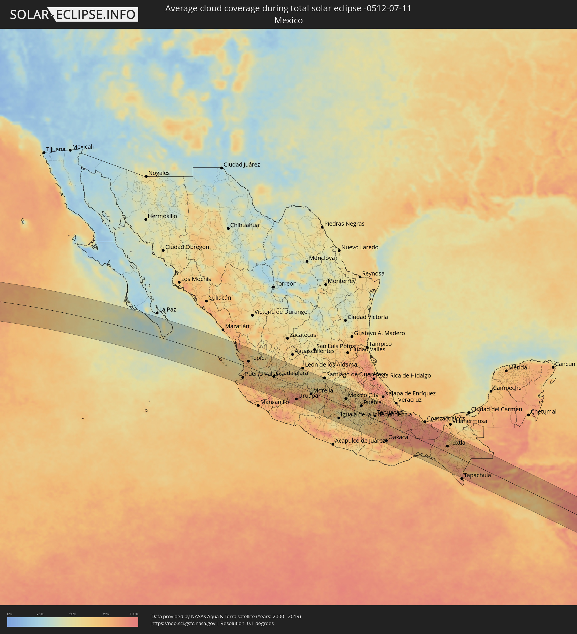 Mexico
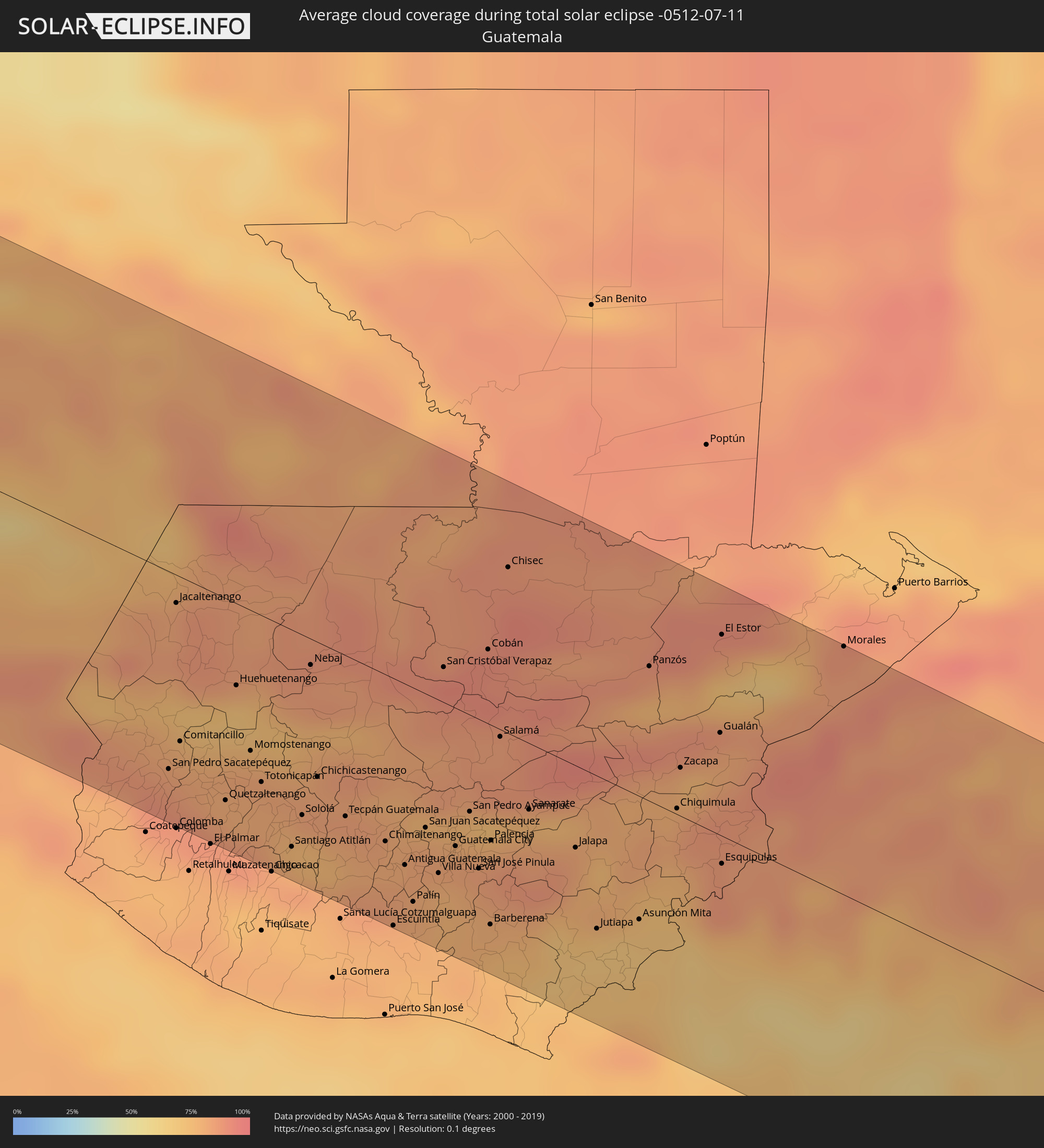 Guatemala
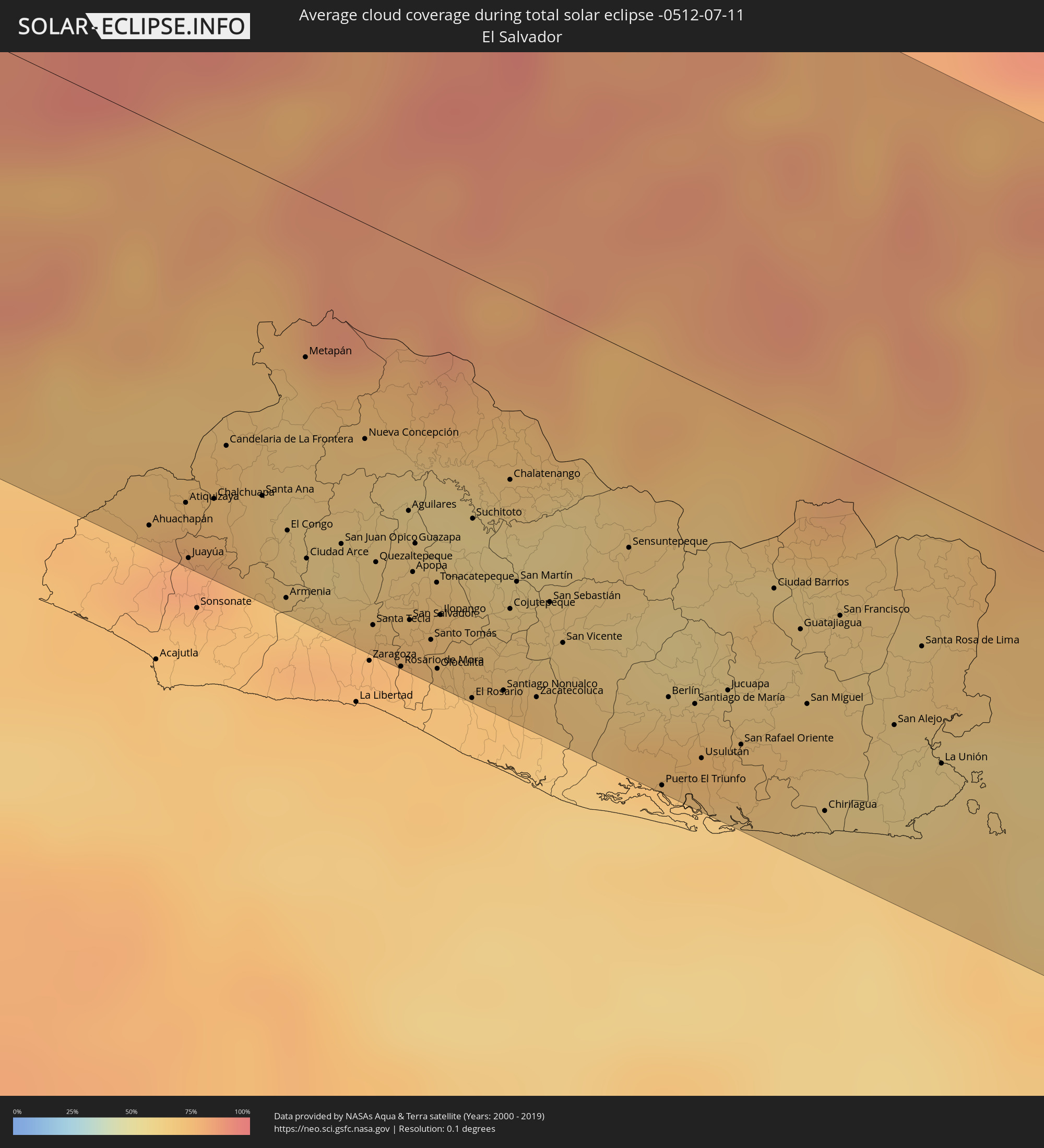 El Salvador
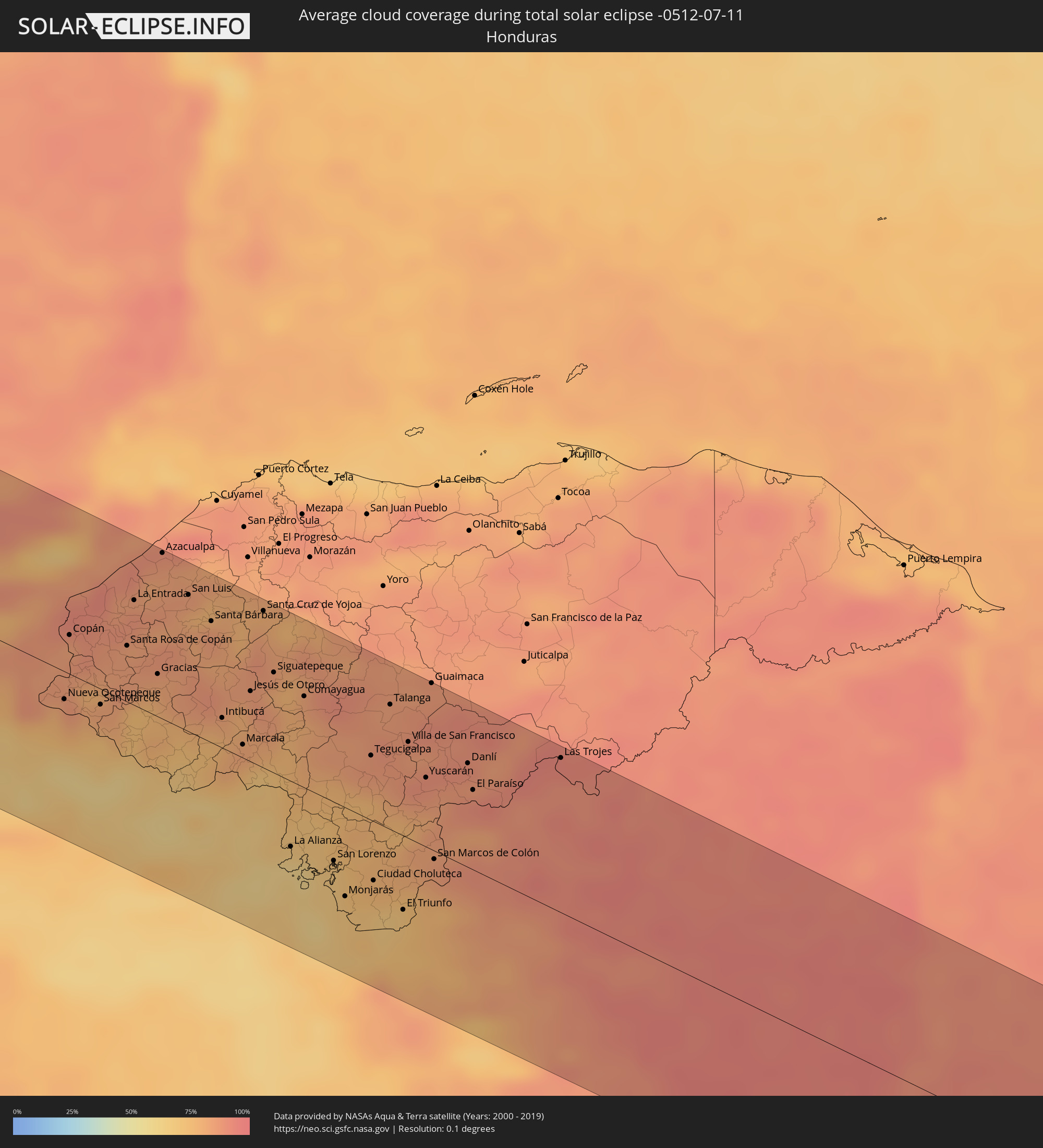 Honduras
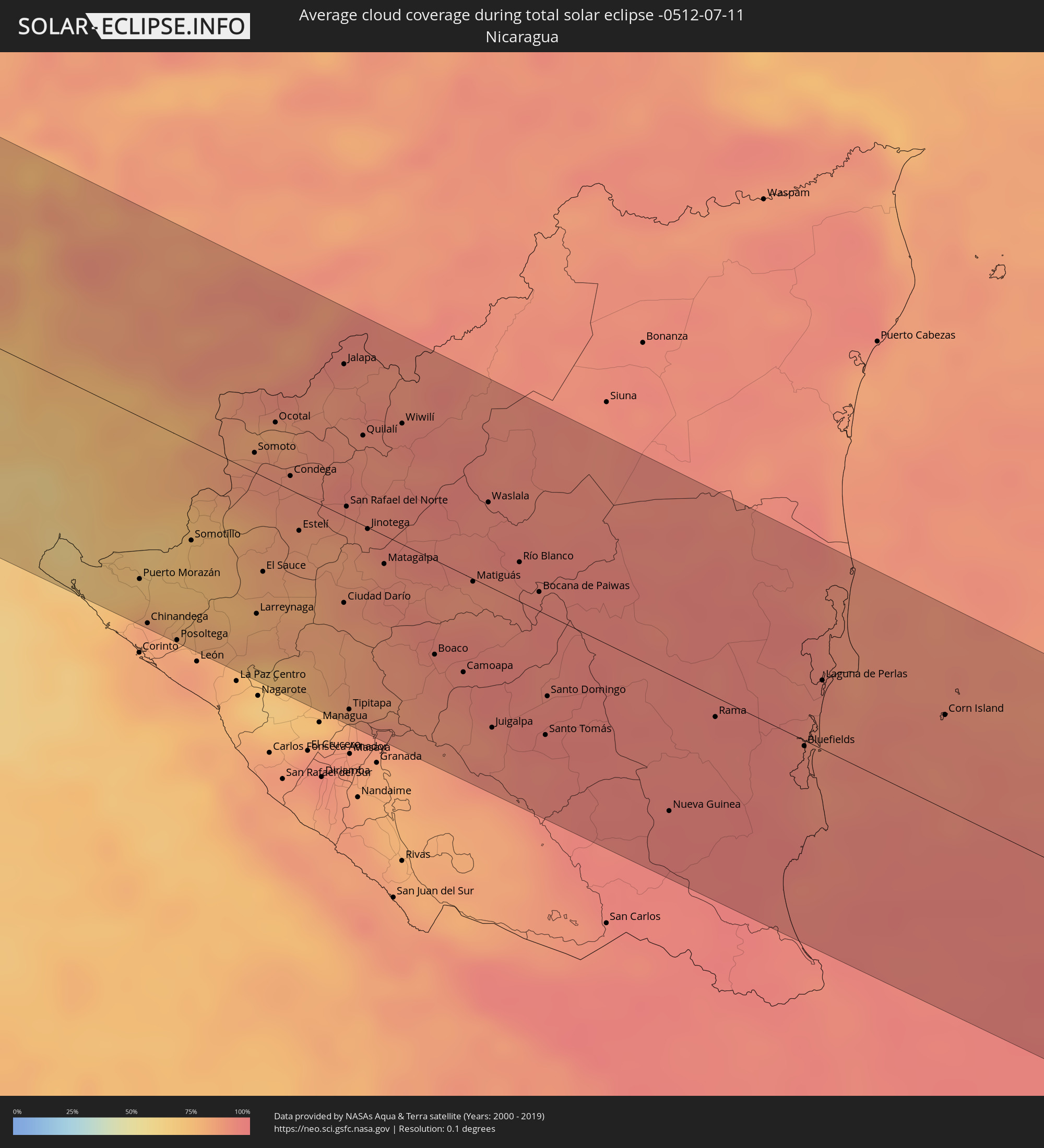 Nicaragua
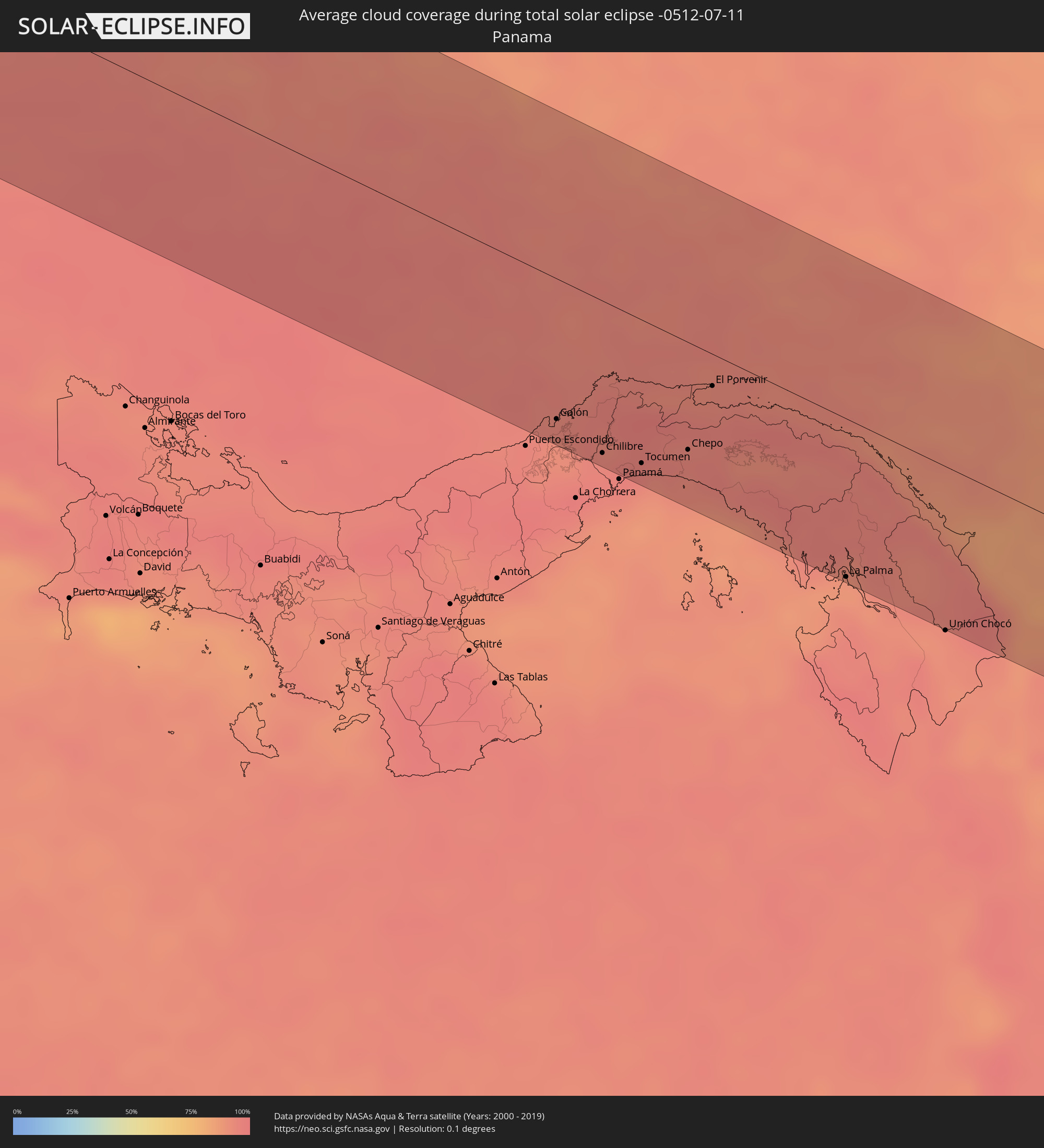 Panama
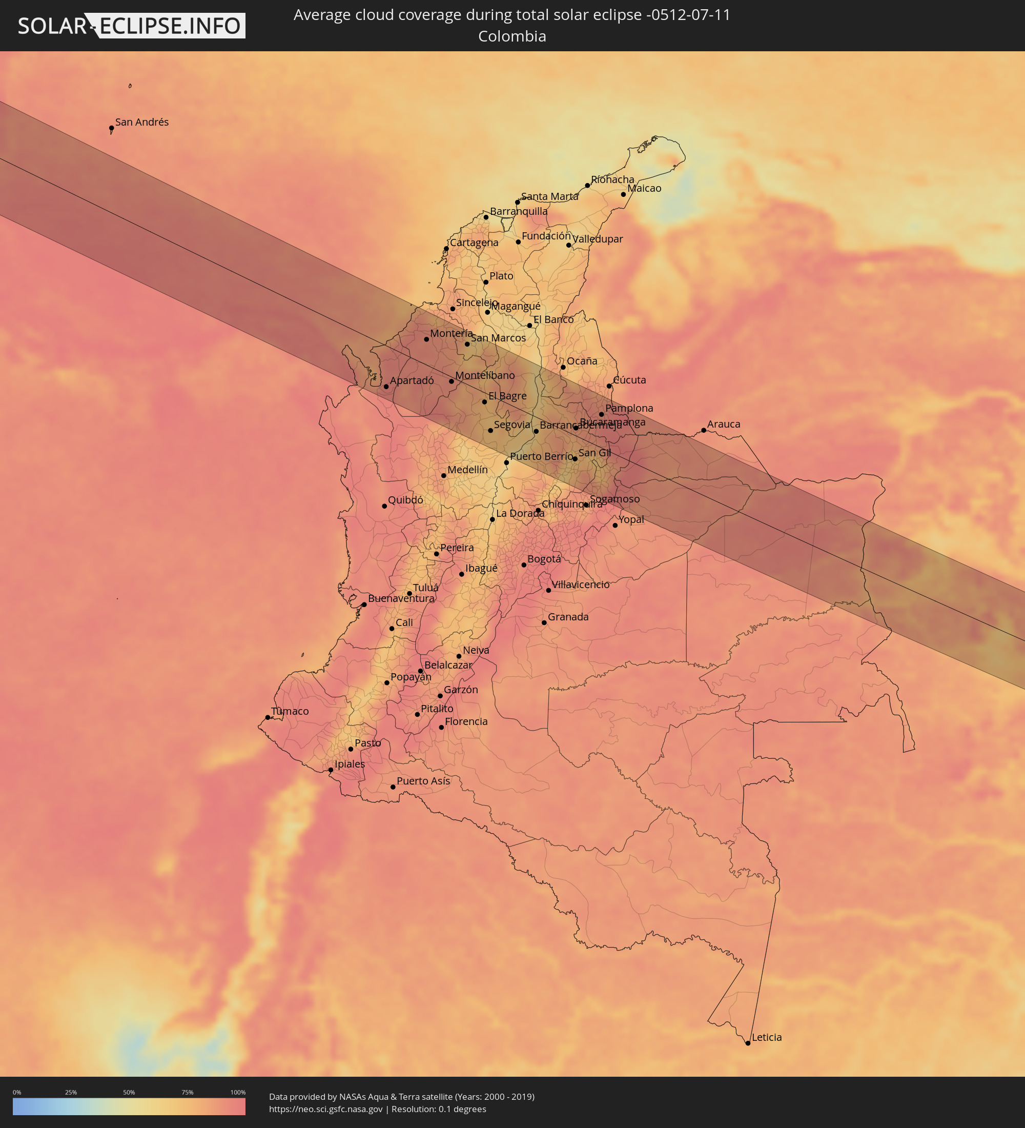 Colombia
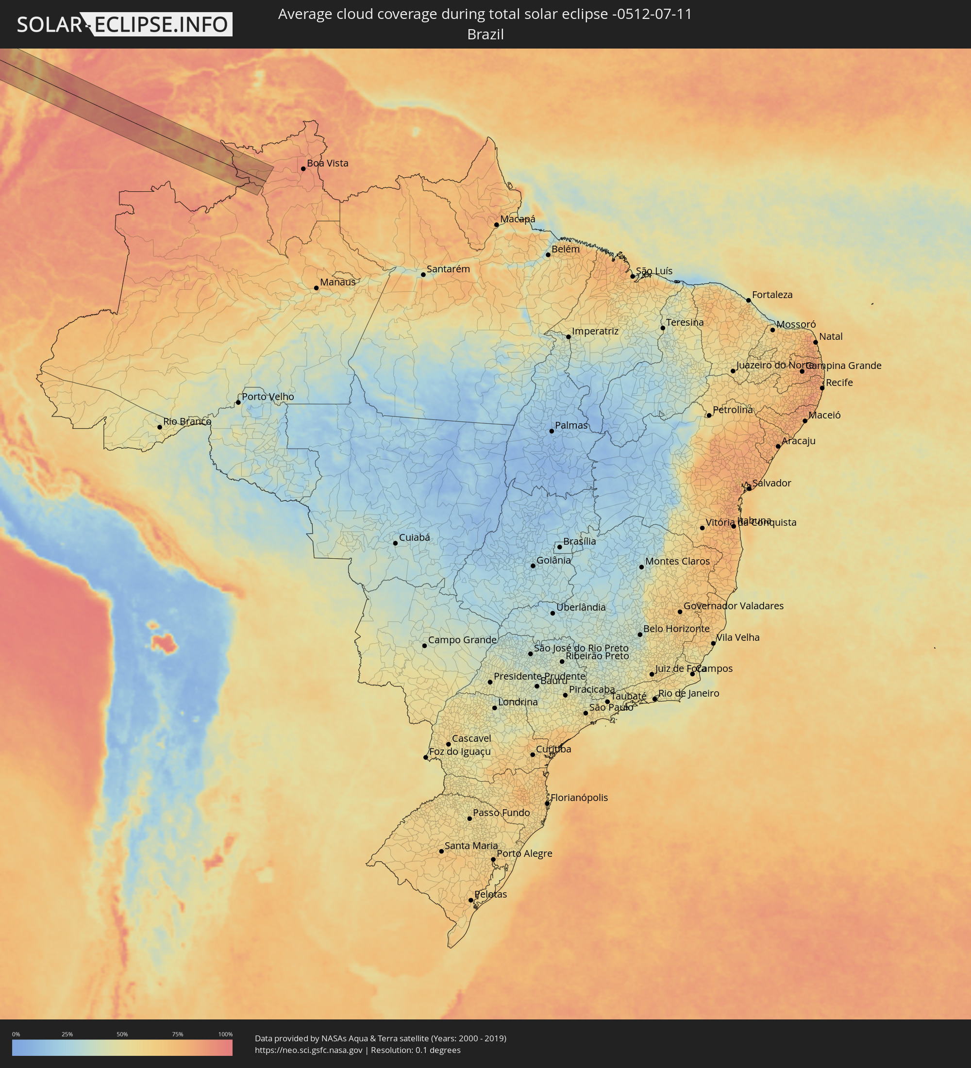 Brazil
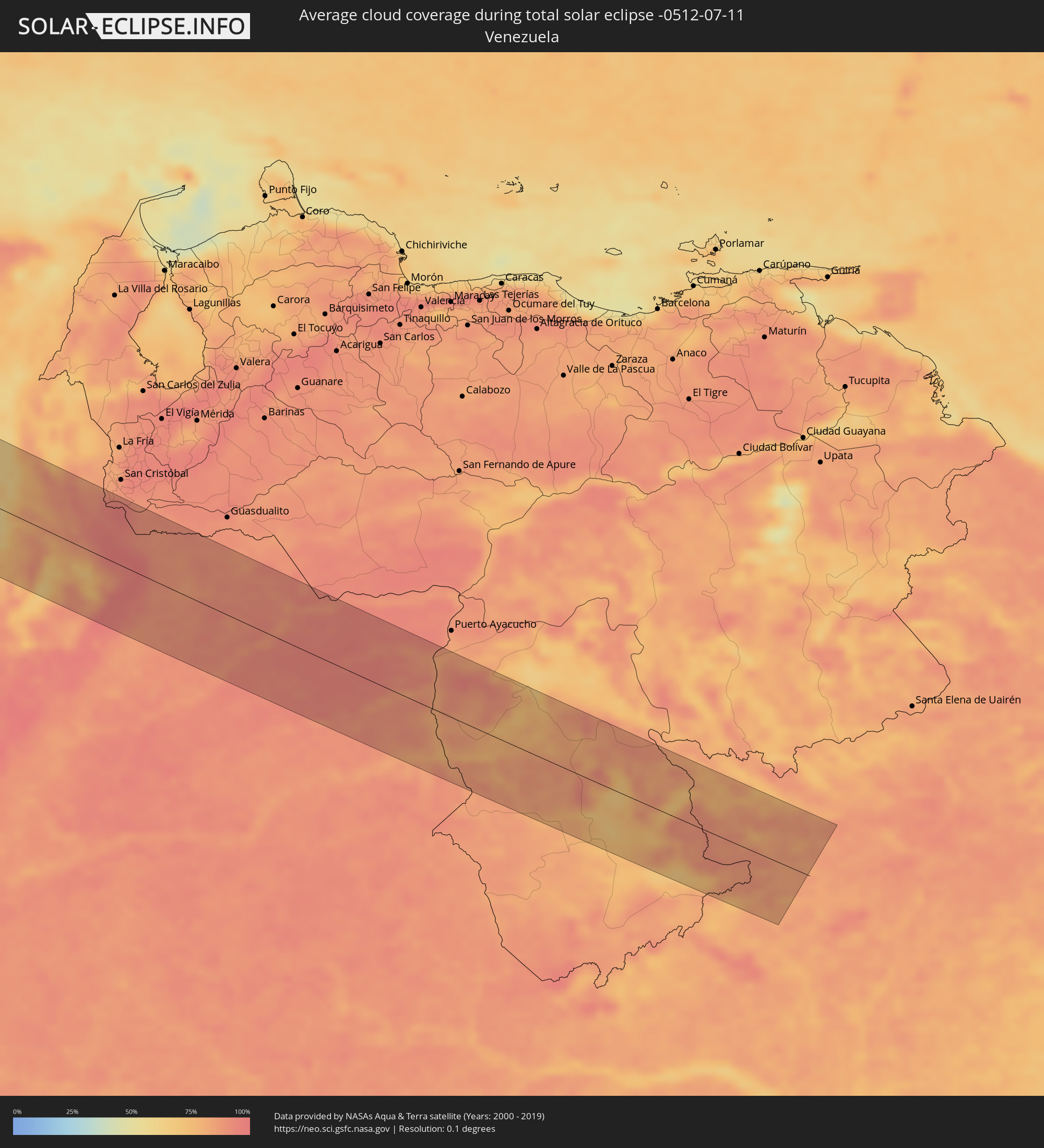 Venezuela
Cities inside the path of the eclipse
The following table shows all locations with a population of more than 5,000 inside the eclipse path. Cities which have more than 100,000 inhabitants are marked bold. A click at the locations opens a detailed map.
| City | Type | Eclipse duration | Local time of max. eclipse | Distance to central line | Ø Cloud coverage |
|
Hawaiian Paradise Park, Hawaii
|
total | - | 08:52:32 UTC-10:30 | 95 km | 82% |
|
Puerto Vallarta, Jalisco
|
total | - | 14:52:02 UTC-06:36 | 72 km | 75% |
|
Tepic, Nayarit
|
total | - | 14:22:47 UTC-07:05 | 34 km | 73% |
|
Guadalajara, Jalisco
|
total | - | 14:55:24 UTC-06:36 | 2 km | 71% |
|
Tonalá, Jalisco
|
total | - | 14:55:44 UTC-06:36 | 3 km | 66% |
|
Uruapan, Michoacán
|
total | - | 14:58:56 UTC-06:36 | 77 km | 79% |
|
Irapuato, Guanajuato
|
total | - | 14:58:55 UTC-06:36 | 81 km | 53% |
|
Salamanca, Guanajuato
|
total | - | 14:59:17 UTC-06:36 | 77 km | 49% |
|
Morelia, Michoacán
|
total | - | 15:00:08 UTC-06:36 | 12 km | 71% |
|
Celaya, Guanajuato
|
total | - | 14:59:57 UTC-06:36 | 87 km | 52% |
|
Santiago de Querétaro, Querétaro
|
total | - | 15:00:34 UTC-06:36 | 111 km | 54% |
|
Toluca, México
|
total | - | 15:03:00 UTC-06:36 | 8 km | 66% |
|
Ciudad López Mateos, México
|
total | - | 15:03:19 UTC-06:36 | 54 km | 57% |
|
Cuernavaca, Morelos
|
total | - | 15:04:00 UTC-06:36 | 12 km | 60% |
|
Tlalpan, Mexico City
|
total | - | 15:03:44 UTC-06:36 | 29 km | 69% |
|
Mexico City, Mexico City
|
total | - | 15:03:40 UTC-06:36 | 44 km | 61% |
|
Ecatepec, México
|
total | - | 15:03:35 UTC-06:36 | 66 km | 60% |
|
Santa María Chimalhuacán, México
|
total | - | 15:03:57 UTC-06:36 | 50 km | 60% |
|
Cuautla Morelos, Morelos
|
total | - | 15:04:33 UTC-06:36 | 12 km | 59% |
|
San Miguel Xico Viejo, México
|
total | - | 15:04:07 UTC-06:36 | 36 km | 69% |
|
Puebla, Puebla
|
total | - | 15:05:26 UTC-06:36 | 43 km | 63% |
|
Tehuacán, Puebla
|
total | - | 15:07:09 UTC-06:36 | 18 km | 67% |
|
Córdoba, Veracruz
|
total | - | 15:07:24 UTC-06:36 | 82 km | 81% |
|
Oaxaca, Oaxaca
|
total | - | 15:09:24 UTC-06:36 | 94 km | 77% |
|
Minatitlan, Veracruz
|
total | - | 15:11:23 UTC-06:36 | 96 km | 83% |
|
Tuxtla, Chiapas
|
total | - | 15:14:17 UTC-06:36 | 35 km | 81% |
|
San Pedro Sacatepéquez, San Marcos
|
total | - | 15:51:56 UTC-06:02 | 84 km | 87% |
|
Jacaltenango, Huehuetenango
|
total | - | 15:51:21 UTC-06:02 | 12 km | 87% |
|
Quetzaltenango, Quetzaltenango
|
total | - | 15:52:19 UTC-06:02 | 86 km | 85% |
|
Huehuetenango, Huehuetenango
|
total | - | 15:51:57 UTC-06:02 | 35 km | 71% |
|
Momostenango, Totonicapán
|
total | - | 15:52:15 UTC-06:02 | 60 km | 81% |
|
Totonicapán, Totonicapán
|
total | - | 15:52:25 UTC-06:02 | 71 km | 80% |
|
Santiago Atitlán, Sololá
|
total | - | 15:52:48 UTC-06:02 | 92 km | 84% |
|
Sololá, Sololá
|
total | - | 15:52:44 UTC-06:02 | 76 km | 75% |
|
Chichicastenango, Quiché
|
total | - | 15:52:40 UTC-06:02 | 57 km | 83% |
|
Chimaltenango, Chimaltenango
|
total | - | 15:53:12 UTC-06:02 | 71 km | 80% |
|
Escuintla, Escuintla
|
total | - | 15:53:33 UTC-06:02 | 105 km | 78% |
|
Ciudad Vieja, Sacatepéquez
|
total | - | 15:53:23 UTC-06:02 | 82 km | 82% |
|
San Juan Sacatepéquez, Guatemala
|
total | - | 15:53:20 UTC-06:02 | 57 km | 82% |
|
Petapa, Guatemala
|
total | - | 15:53:37 UTC-06:02 | 74 km | 77% |
|
Guatemala City, Guatemala
|
total | - | 15:53:32 UTC-06:02 | 59 km | 80% |
|
San Pedro Ayampuc, Guatemala
|
total | - | 15:53:28 UTC-06:02 | 41 km | 79% |
|
San José Pinula, Guatemala
|
total | - | 15:53:43 UTC-06:02 | 63 km | 79% |
|
Cobán, Alta Verapaz
|
total | - | 15:52:57 UTC-06:02 | 31 km | 90% |
|
Barberena, Santa Rosa
|
total | - | 15:53:58 UTC-06:02 | 85 km | 75% |
|
Salamá, Baja Verapaz
|
total | - | 15:53:20 UTC-06:02 | 3 km | 86% |
|
Jalapa, Jalapa
|
total | - | 15:54:04 UTC-06:02 | 35 km | 78% |
|
Jutiapa, Jutiapa
|
total | - | 15:54:27 UTC-06:02 | 65 km | 69% |
|
Ahuachapán, Ahuachapán
|
total | - | 16:00:05 UTC-05:56 | 100 km | 83% |
|
Atiquizaya, Ahuachapán
|
total | - | 16:00:07 UTC-05:56 | 90 km | 78% |
|
Panzós, Alta Verapaz
|
total | - | 15:53:43 UTC-06:02 | 57 km | 76% |
|
Santa Ana, Santa Ana
|
total | - | 16:00:17 UTC-05:56 | 79 km | 70% |
|
Chiquimula, Chiquimula
|
total | - | 15:54:21 UTC-06:02 | 3 km | 86% |
|
Zacapa, Zacapa
|
total | - | 15:54:13 UTC-06:02 | 20 km | 78% |
|
Armenia, Sonsonate
|
total | - | 16:00:34 UTC-05:56 | 101 km | 78% |
|
El Congo, Santa Ana
|
total | - | 16:00:25 UTC-05:56 | 85 km | 66% |
|
Metapán, Santa Ana
|
total | - | 16:00:07 UTC-05:56 | 40 km | 66% |
|
Nueva Concepción, Chalatenango
|
total | - | 16:00:25 UTC-05:56 | 53 km | 64% |
|
Quezaltepeque, La Libertad
|
total | - | 16:00:42 UTC-05:56 | 82 km | 70% |
|
Aguilares, San Salvador
|
total | - | 16:00:40 UTC-05:56 | 65 km | 64% |
|
San Salvador, San Salvador
|
total | - | 16:00:54 UTC-05:56 | 92 km | 75% |
|
Nueva Ocotepeque, Ocotepeque
|
total | - | 16:08:13 UTC-05:48 | 17 km | 76% |
|
Copán, Copán
|
total | - | 16:07:54 UTC-05:48 | 24 km | 84% |
|
Chalatenango, Chalatenango
|
total | - | 16:00:51 UTC-05:56 | 46 km | 59% |
|
Cojutepeque, Cuscatlán
|
total | - | 16:01:07 UTC-05:56 | 78 km | 67% |
|
Zacatecoluca, La Paz
|
total | - | 16:01:21 UTC-05:56 | 96 km | 70% |
|
San Vicente, San Vicente
|
total | - | 16:01:18 UTC-05:56 | 80 km | 68% |
|
Santa Rosa de Copán, Copán
|
total | - | 16:08:18 UTC-05:48 | 35 km | 85% |
|
La Entrada, Copán
|
total | - | 16:08:06 UTC-05:48 | 66 km | 88% |
|
Sensuntepeque, Cabañas
|
total | - | 16:01:16 UTC-05:56 | 48 km | 65% |
|
Jiquilisco, Usulután
|
total | - | 16:01:46 UTC-05:56 | 101 km | 63% |
|
Gracias, Lempira
|
total | - | 16:08:38 UTC-05:48 | 27 km | 80% |
|
Berlín, Usulután
|
total | - | 16:01:39 UTC-05:56 | 80 km | 74% |
|
Usulután, Usulután
|
total | - | 16:01:51 UTC-05:56 | 92 km | 72% |
|
Jucuapa, Usulután
|
total | - | 16:01:47 UTC-05:56 | 72 km | 73% |
|
El Tránsito, San Miguel
|
total | - | 16:01:57 UTC-05:56 | 87 km | 73% |
|
Chinameca, San Miguel
|
total | - | 16:01:49 UTC-05:56 | 72 km | 73% |
|
Santa Bárbara, Santa Bárbara
|
total | - | 16:08:40 UTC-05:48 | 76 km | 85% |
|
San Miguel, San Miguel
|
total | - | 16:01:59 UTC-05:56 | 66 km | 69% |
|
Intibucá, Intibucá
|
total | - | 16:09:14 UTC-05:48 | 19 km | 75% |
|
San Francisco, Morazán
|
total | - | 16:01:53 UTC-05:56 | 40 km | 65% |
|
Las Vegas, Santa Barbara, Santa Bárbara
|
total | - | 16:08:50 UTC-05:48 | 79 km | 82% |
|
Marcala, La Paz
|
total | - | 16:09:30 UTC-05:48 | 8 km | 82% |
|
Jesús de Otoro, Intibucá
|
total | - | 16:09:15 UTC-05:48 | 44 km | 79% |
|
Santa Cruz de Yojoa, Cortés
|
total | - | 16:08:54 UTC-05:48 | 98 km | 82% |
|
Santa Rosa de Lima, La Unión
|
total | - | 16:02:07 UTC-05:56 | 38 km | 65% |
|
La Unión, La Unión
|
total | - | 16:02:24 UTC-05:56 | 64 km | 63% |
|
Siguatepeque, Comayagua
|
total | - | 16:09:17 UTC-05:48 | 63 km | 80% |
|
La Alianza, Valle
|
total | - | 16:10:18 UTC-05:48 | 41 km | 61% |
|
La Paz, La Paz
|
total | - | 16:09:40 UTC-05:48 | 42 km | 77% |
|
Comayagua, Comayagua
|
total | - | 16:09:35 UTC-05:48 | 57 km | 82% |
|
San Lorenzo, Valle
|
total | - | 16:10:36 UTC-05:48 | 37 km | 69% |
|
Monjarás, Choluteca
|
total | - | 16:10:51 UTC-05:48 | 56 km | 68% |
|
Tegucigalpa, Francisco Morazán
|
total | - | 16:10:16 UTC-05:48 | 40 km | 86% |
|
Ciudad Choluteca, Choluteca
|
total | - | 16:10:55 UTC-05:48 | 37 km | 74% |
|
Chinandega, Chinandega
|
total | - | 16:15:10 UTC-05:45 | 101 km | 83% |
|
Talanga, Francisco Morazán
|
total | - | 16:10:06 UTC-05:48 | 78 km | 85% |
|
El Triunfo, Choluteca
|
total | - | 16:11:13 UTC-05:48 | 46 km | 69% |
|
Somotillo, Chinandega
|
total | - | 16:15:02 UTC-05:45 | 49 km | 73% |
|
Telica, León
|
total | - | 16:15:29 UTC-05:45 | 99 km | 86% |
|
Guaimaca, Francisco Morazán
|
total | - | 16:10:12 UTC-05:48 | 104 km | 87% |
|
San Marcos de Colón, Choluteca
|
total | - | 16:11:08 UTC-05:48 | 5 km | 82% |
|
Danlí, El Paraíso
|
total | - | 16:10:49 UTC-05:48 | 65 km | 87% |
|
Somoto, Madriz
|
total | - | 16:14:56 UTC-05:45 | 10 km | 88% |
|
El Paraíso, El Paraíso
|
total | - | 16:10:59 UTC-05:48 | 50 km | 89% |
|
El Sauce, León
|
total | - | 16:15:27 UTC-05:45 | 48 km | 82% |
|
Ocotal, Nueva Segovia
|
total | - | 16:14:54 UTC-05:45 | 30 km | 87% |
|
Condega, Estelí
|
total | - | 16:15:11 UTC-05:45 | 7 km | 89% |
|
Estelí, Estelí
|
total | - | 16:15:26 UTC-05:45 | 18 km | 85% |
|
Ciudad Darío, Matagalpa
|
total | - | 16:15:54 UTC-05:45 | 43 km | 86% |
|
Jalapa, Nueva Segovia
|
total | - | 16:14:56 UTC-05:45 | 76 km | 90% |
|
Tipitapa, Managua
|
total | - | 16:16:20 UTC-05:45 | 96 km | 88% |
|
Quilalí, Nueva Segovia
|
total | - | 16:15:18 UTC-05:45 | 45 km | 90% |
|
Jinotega, Jinotega
|
total | - | 16:15:42 UTC-05:45 | 1 km | 89% |
|
Matagalpa, Matagalpa
|
total | - | 16:15:54 UTC-05:45 | 14 km | 91% |
|
San Lorenzo, Boaco
|
total | - | 16:16:31 UTC-05:45 | 57 km | 89% |
|
Boaco, Boaco
|
total | - | 16:16:27 UTC-05:45 | 47 km | 91% |
|
Camoapa, Boaco
|
total | - | 16:16:38 UTC-05:45 | 49 km | 91% |
|
Matiguás, Matagalpa
|
total | - | 16:16:19 UTC-05:45 | 2 km | 90% |
|
Juigalpa, Chontales
|
total | - | 16:16:58 UTC-05:45 | 70 km | 93% |
|
Río Blanco, Matagalpa
|
total | - | 16:16:25 UTC-05:45 | 20 km | 93% |
|
Acoyapa, Chontales
|
total | - | 16:17:12 UTC-05:45 | 74 km | 94% |
|
Santo Tomás, Chontales
|
total | - | 16:17:11 UTC-05:45 | 61 km | 93% |
|
Nueva Guinea, Atlántico Sur
|
total | - | 16:17:55 UTC-05:45 | 69 km | 96% |
|
Rama, Atlántico Sur
|
total | - | 16:17:44 UTC-05:45 | 10 km | 95% |
|
Bluefields, Atlántico Sur
|
total | - | 16:18:09 UTC-05:45 | 3 km | 93% |
|
Colón, Colón
|
total | - | 16:47:48 UTC-05:19 | 84 km | 93% |
|
Cativá, Colón
|
total | - | 16:47:50 UTC-05:19 | 80 km | 94% |
|
Sabanitas, Colón
|
total | - | 16:47:51 UTC-05:19 | 81 km | 93% |
|
Puerto Pilón, Colón
|
total | - | 16:47:51 UTC-05:19 | 78 km | 94% |
|
Chilibre, Panamá
|
total | - | 16:48:04 UTC-05:19 | 91 km | 94% |
|
Alcalde Díaz, Panamá
|
total | - | 16:48:07 UTC-05:19 | 91 km | 95% |
|
La Cabima, Panamá
|
total | - | 16:48:08 UTC-05:19 | 91 km | 97% |
|
Las Cumbres, Panamá
|
total | - | 16:48:09 UTC-05:19 | 93 km | 97% |
|
San Miguelito, Panamá
|
total | - | 16:48:12 UTC-05:19 | 94 km | 97% |
|
Tocumen, Panamá
|
total | - | 16:48:13 UTC-05:19 | 86 km | 95% |
|
Pacora, Panamá
|
total | - | 16:48:16 UTC-05:19 | 83 km | 93% |
|
Chepo, Panamá
|
total | - | 16:48:17 UTC-05:19 | 65 km | 95% |
|
El Porvenir, Guna Yala
|
total | - | 16:48:07 UTC-05:19 | 19 km | 92% |
|
La Palma, Darién
|
total | - | 16:49:10 UTC-05:19 | 95 km | 88% |
|
Turbo, Antioquia
|
total | - | 17:13:13 UTC-04:56 | 60 km | 90% |
|
Apartadó, Antioquia
|
total | - | 17:13:22 UTC-04:56 | 76 km | 95% |
|
Tierralta, Córdoba
|
total | - | 17:13:23 UTC-04:56 | 20 km | 92% |
|
Montería, Córdoba
|
total | - | 17:13:06 UTC-04:56 | 46 km | 92% |
|
Cereté, Córdoba
|
total | - | 17:13:03 UTC-04:56 | 64 km | 90% |
|
Ciénaga de Oro, Córdoba
|
total | - | 17:13:06 UTC-04:56 | 71 km | 88% |
|
Planeta Rica, Córdoba
|
total | - | 17:13:23 UTC-04:56 | 27 km | 90% |
|
Sahagún, Córdoba
|
total | - | 17:13:07 UTC-04:56 | 87 km | 86% |
|
Montelíbano, Córdoba
|
total | - | 17:13:42 UTC-04:56 | 9 km | 91% |
|
Caucasia, Antioquia
|
total | - | 17:13:45 UTC-04:56 | 3 km | 79% |
|
Ayapel, Córdoba
|
total | - | 17:13:35 UTC-04:56 | 38 km | 82% |
|
San Marcos, Sucre
|
total | - | 17:13:23 UTC-04:56 | 73 km | 70% |
|
El Bagre, Antioquia
|
total | - | 17:14:05 UTC-04:56 | 18 km | 75% |
|
San Carlos, Antioquia
|
total | - | 17:13:59 UTC-04:56 | 3 km | 74% |
|
Segovia, Antioquia
|
total | - | 17:14:24 UTC-04:56 | 65 km | 73% |
|
Puerto Wilches, Santander
|
total | - | 17:14:27 UTC-04:56 | 1 km | 62% |
|
Morales, Bolívar
|
total | - | 17:13:56 UTC-04:56 | 94 km | 62% |
|
Barrancabermeja, Santander
|
total | - | 17:14:37 UTC-04:56 | 27 km | 66% |
|
Socorro, Santander
|
total | - | 17:15:04 UTC-04:56 | 59 km | 68% |
|
San Gil, Santander
|
total | - | 17:15:02 UTC-04:56 | 44 km | 71% |
|
Bucaramanga, Santander
|
total | - | 17:14:44 UTC-04:56 | 14 km | 84% |
|
Piedecuesta, Santander
|
total | - | 17:14:50 UTC-04:56 | 3 km | 83% |
|
Málaga, Santander
|
total | - | 17:15:03 UTC-04:56 | 11 km | 75% |
|
Pamplona, Norte de Santander
|
total | - | 17:14:42 UTC-04:56 | 61 km | 92% |
|
Tame, Arauca
|
total | - | 17:15:20 UTC-04:56 | 12 km | 88% |