Total solar eclipse of 06/20/-0529
| Day of week: | Sunday |
| Maximum duration of eclipse: | 01m30s |
| Maximum width of eclipse path: | 180 km |
| Saros cycle: | 67 |
| Coverage: | 100% |
| Magnitude: | 1.0253 |
| Gamma: | 0.8754 |
Wo kann man die Sonnenfinsternis vom 06/20/-0529 sehen?
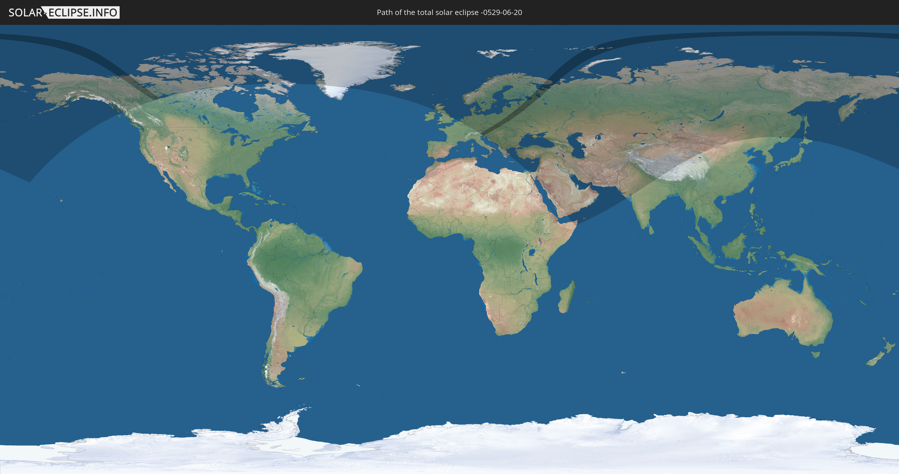
Die Sonnenfinsternis am 06/20/-0529 kann man in 71 Ländern als partielle Sonnenfinsternis beobachten.
Der Finsternispfad verläuft durch 13 Länder. Nur in diesen Ländern ist sie als total Sonnenfinsternis zu sehen.
In den folgenden Ländern ist die Sonnenfinsternis total zu sehen
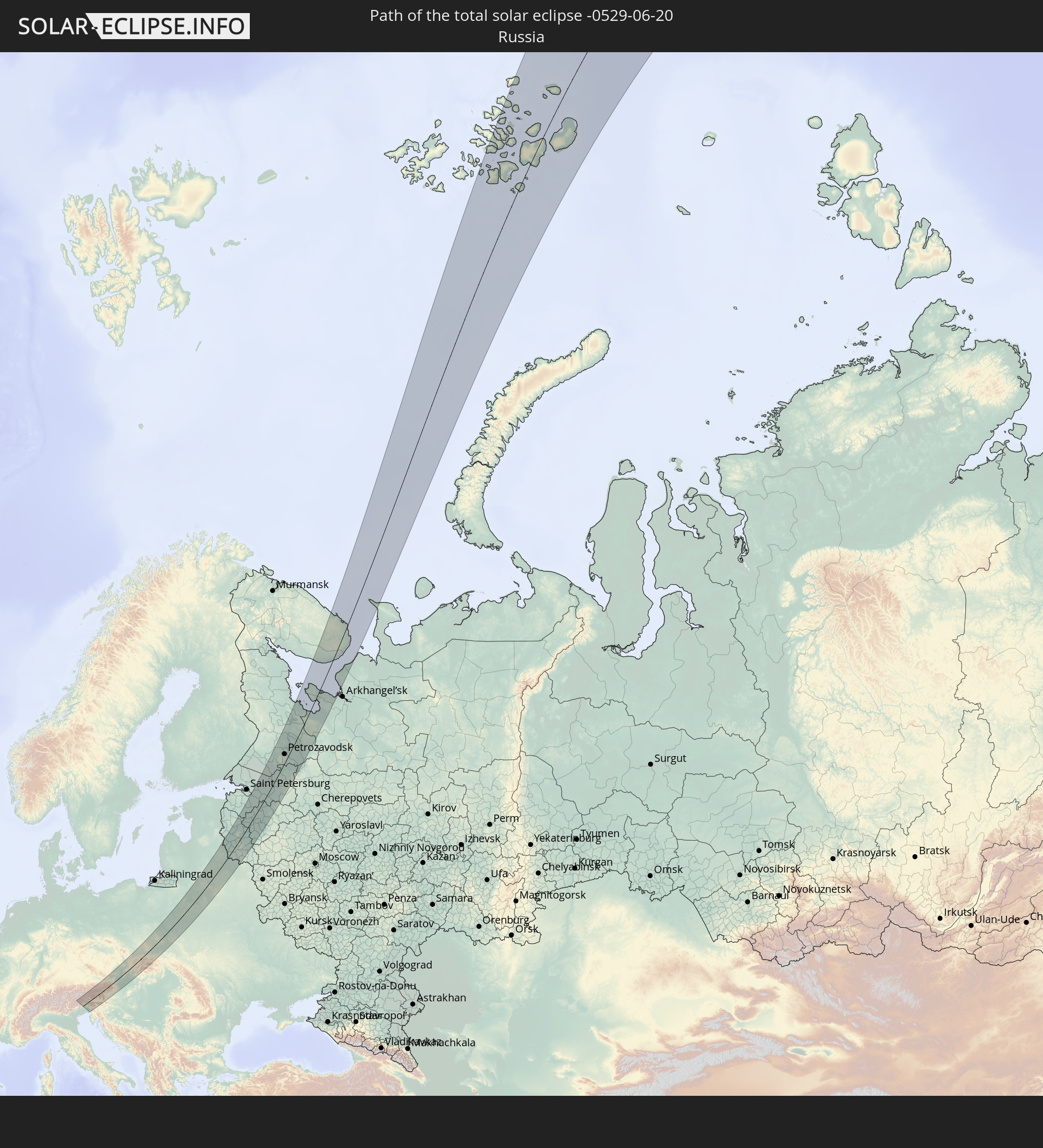 Russia
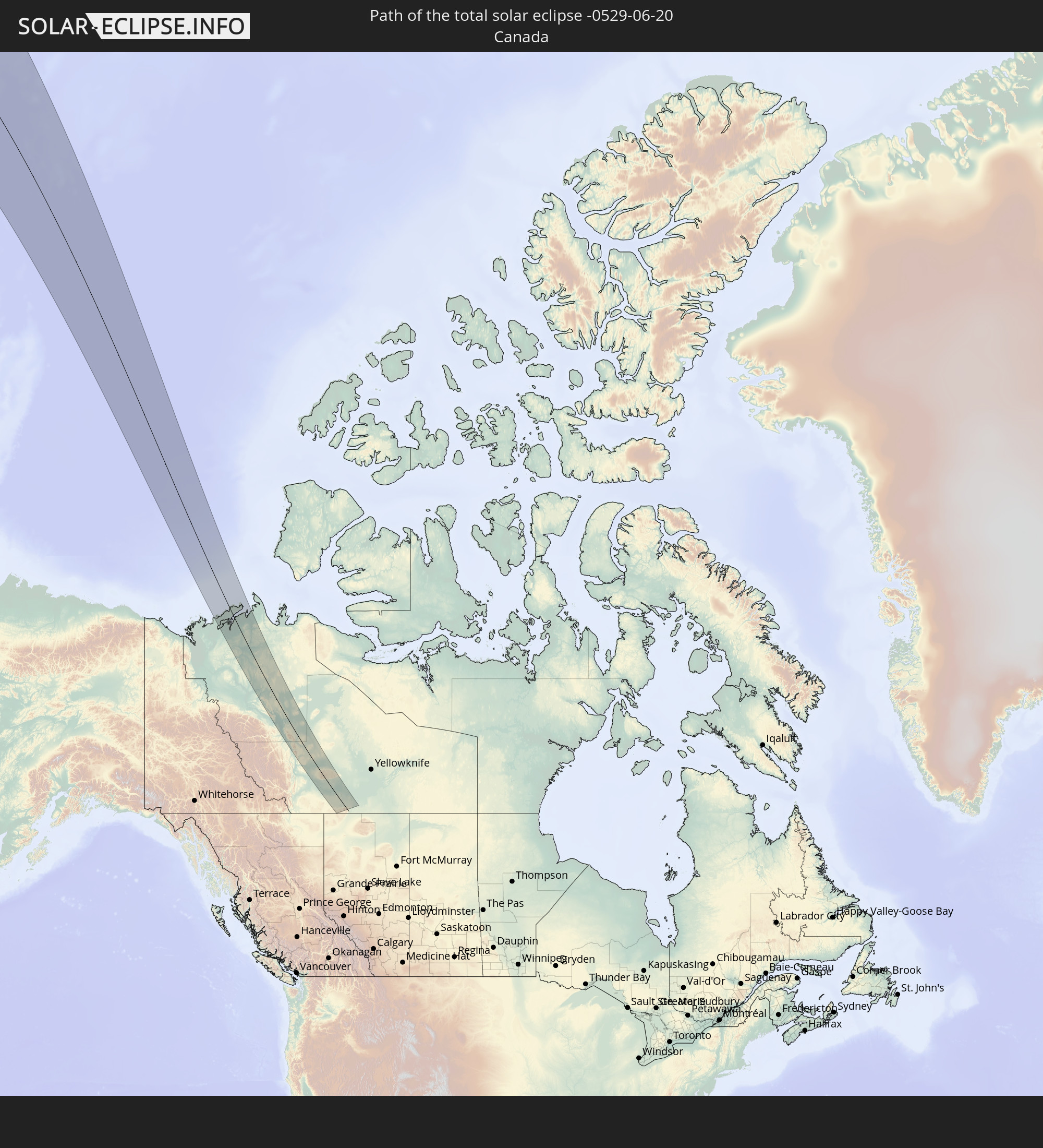 Canada
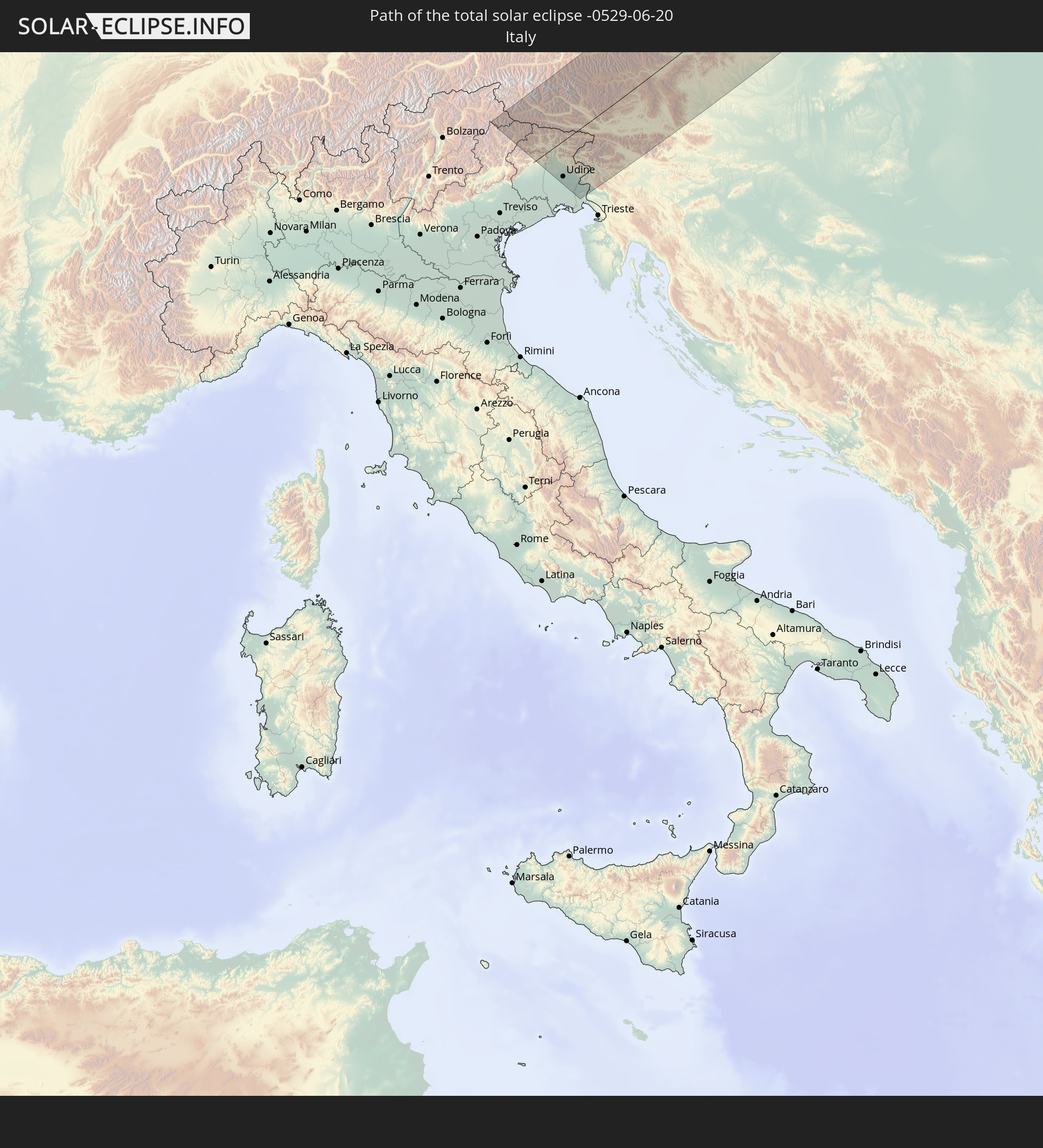 Italy
Italy
 Austria
 Czechia
 Slovenia
 Poland
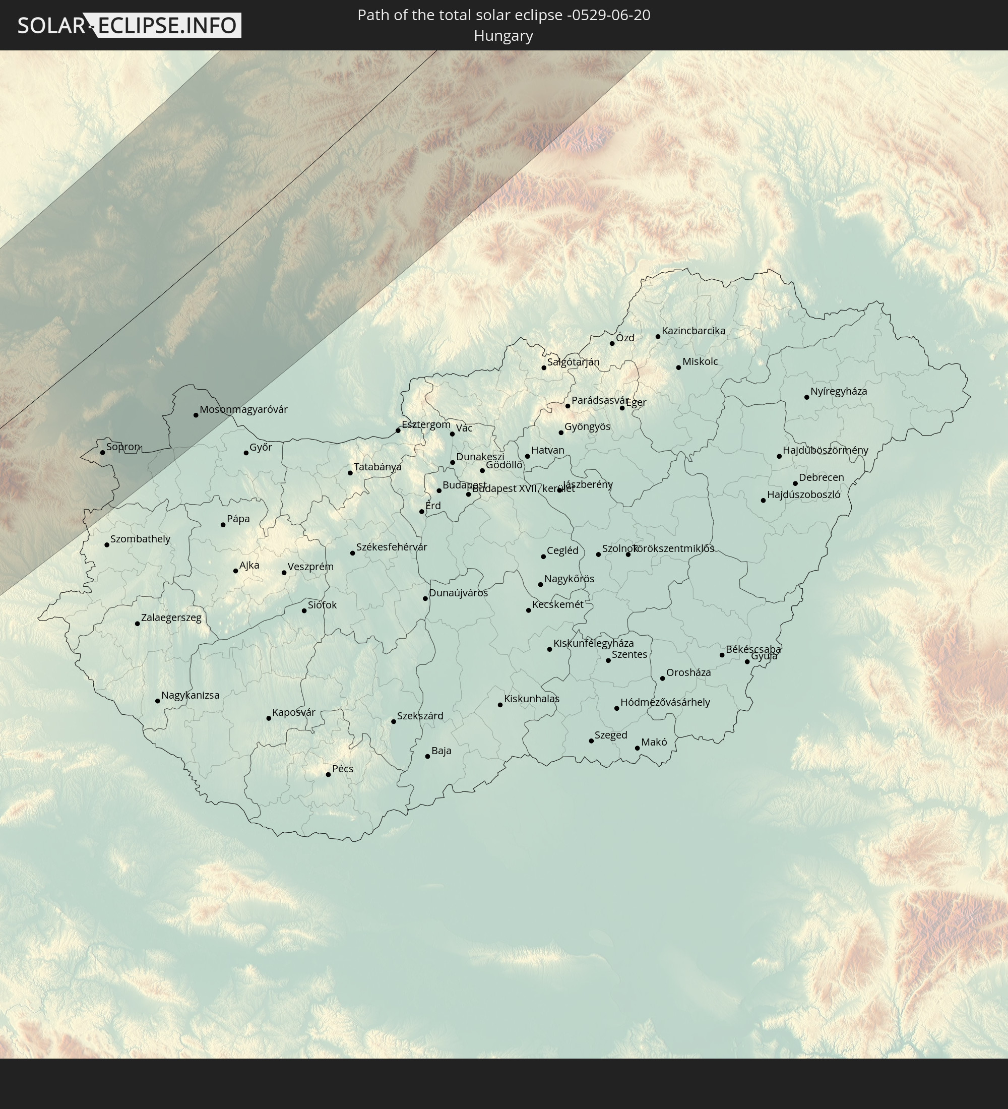 Hungary
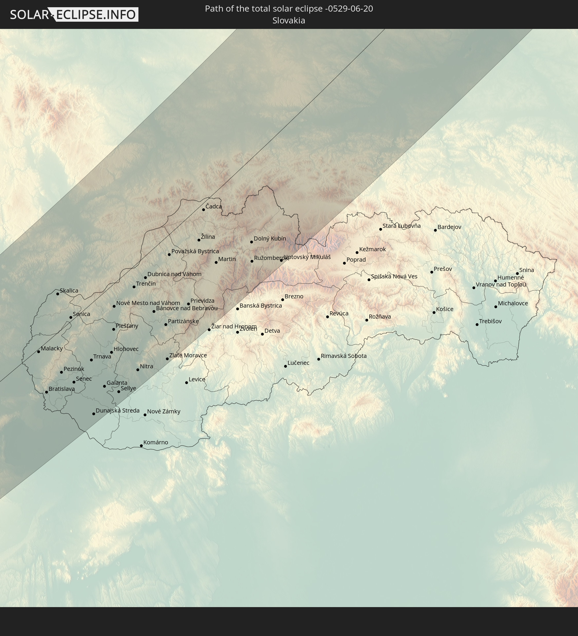 Slovakia
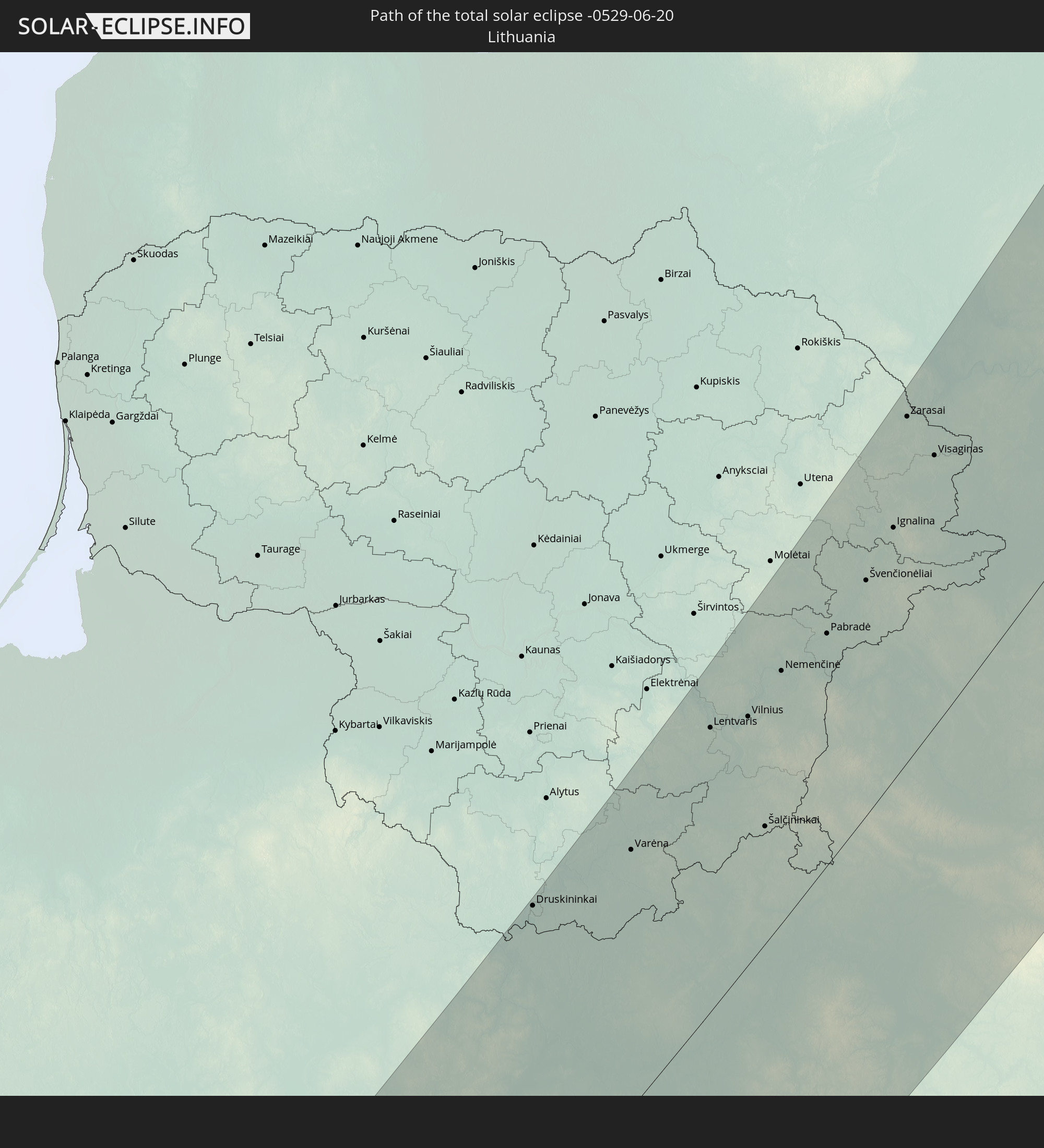 Lithuania
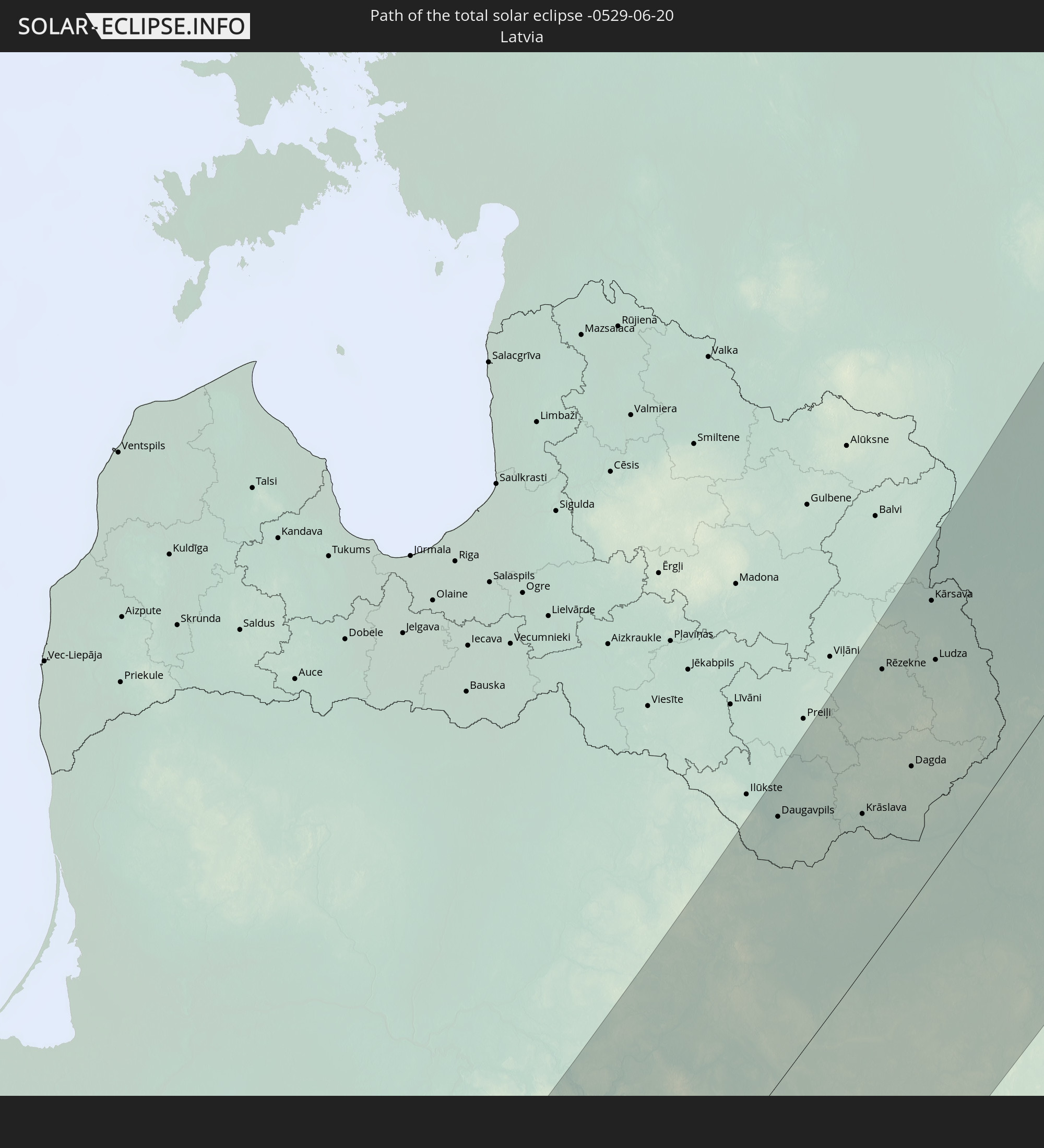 Latvia
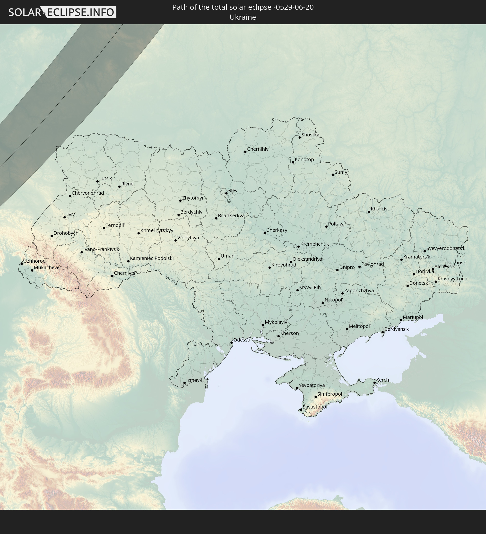 Ukraine
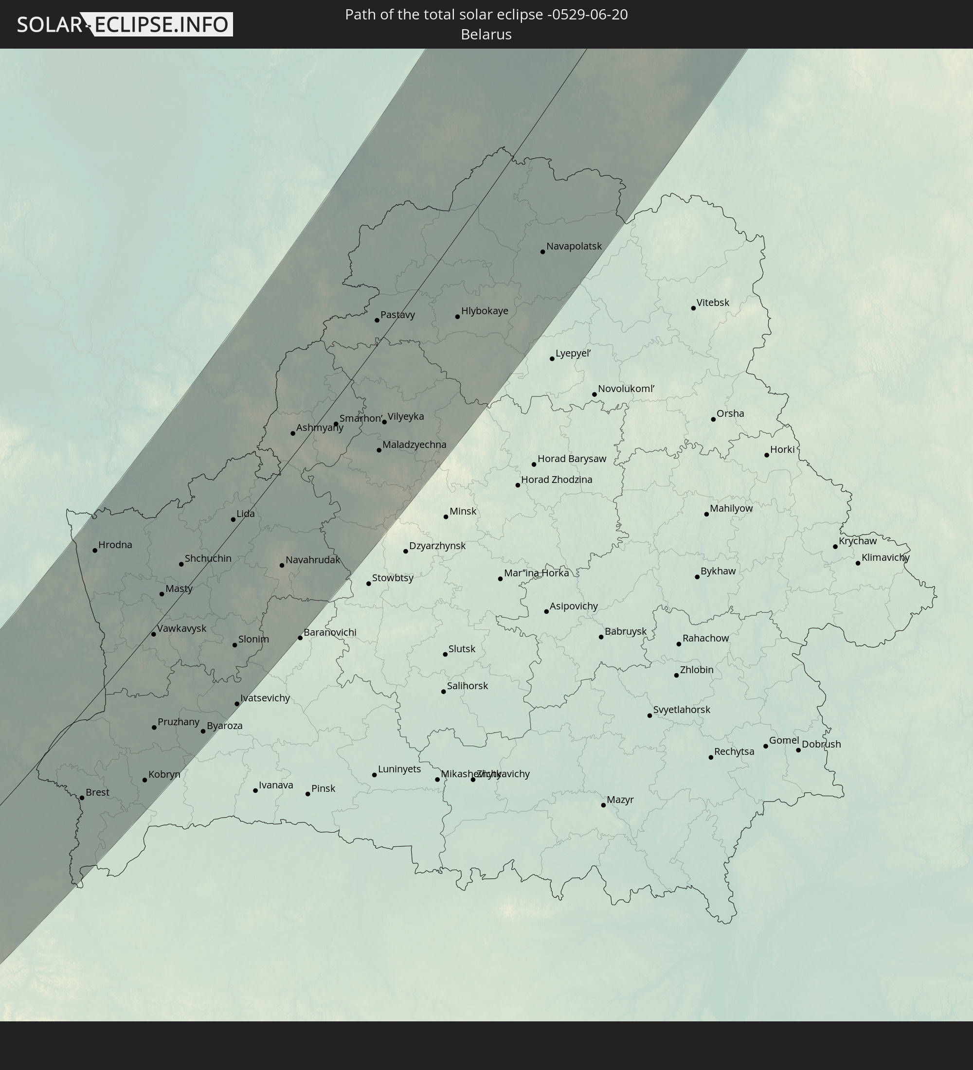 Belarus
In den folgenden Ländern ist die Sonnenfinsternis partiell zu sehen
 Russia
 United States
 Canada
 Greenland
 Iceland
 Svalbard and Jan Mayen
 United Kingdom
 Faroe Islands
 Belgium
 Netherlands
 Norway
 Germany
 Italy
Italy
 Denmark
 Austria
 Sweden
 Czechia
 Slovenia
 Croatia
 Poland
 Bosnia and Herzegovina
 Hungary
 Slovakia
 Montenegro
 Serbia
 Albania
 Åland Islands
 Greece
 Romania
 Republic of Macedonia
 Finland
 Lithuania
 Latvia
 Estonia
 Ukraine
 Bulgaria
 Belarus
 Egypt
Egypt
 Turkey
 Moldova
 Cyprus
 State of Palestine
 Israel
 Saudi Arabia
 Jordan
 Lebanon
 Syria
Syria
 Iraq
Iraq
 Georgia
 Somalia
 Yemen
Yemen
 Armenia
 Iran
Iran
 Azerbaijan
 Kazakhstan
 Kuwait
 Bahrain
 Qatar
Qatar
 United Arab Emirates
 Oman
Oman
 Turkmenistan
 Uzbekistan
 Afghanistan
 Pakistan
 Tajikistan
 India
India
 Kyrgyzstan
 China
China
 Nepal
Nepal
 Mongolia
 Japan
Japan
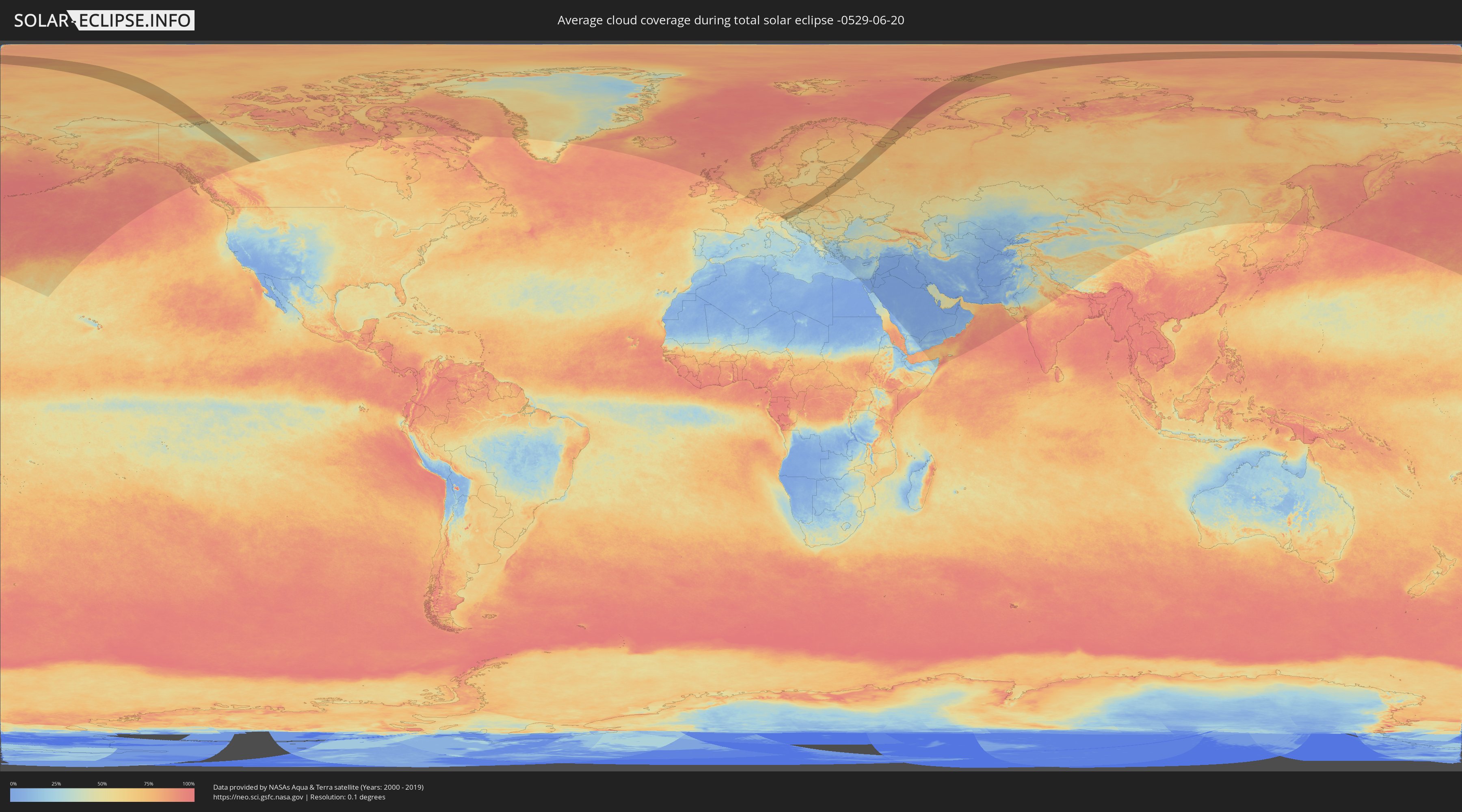
How will be the weather during the total solar eclipse on 06/20/-0529?
Where is the best place to see the total solar eclipse of 06/20/-0529?
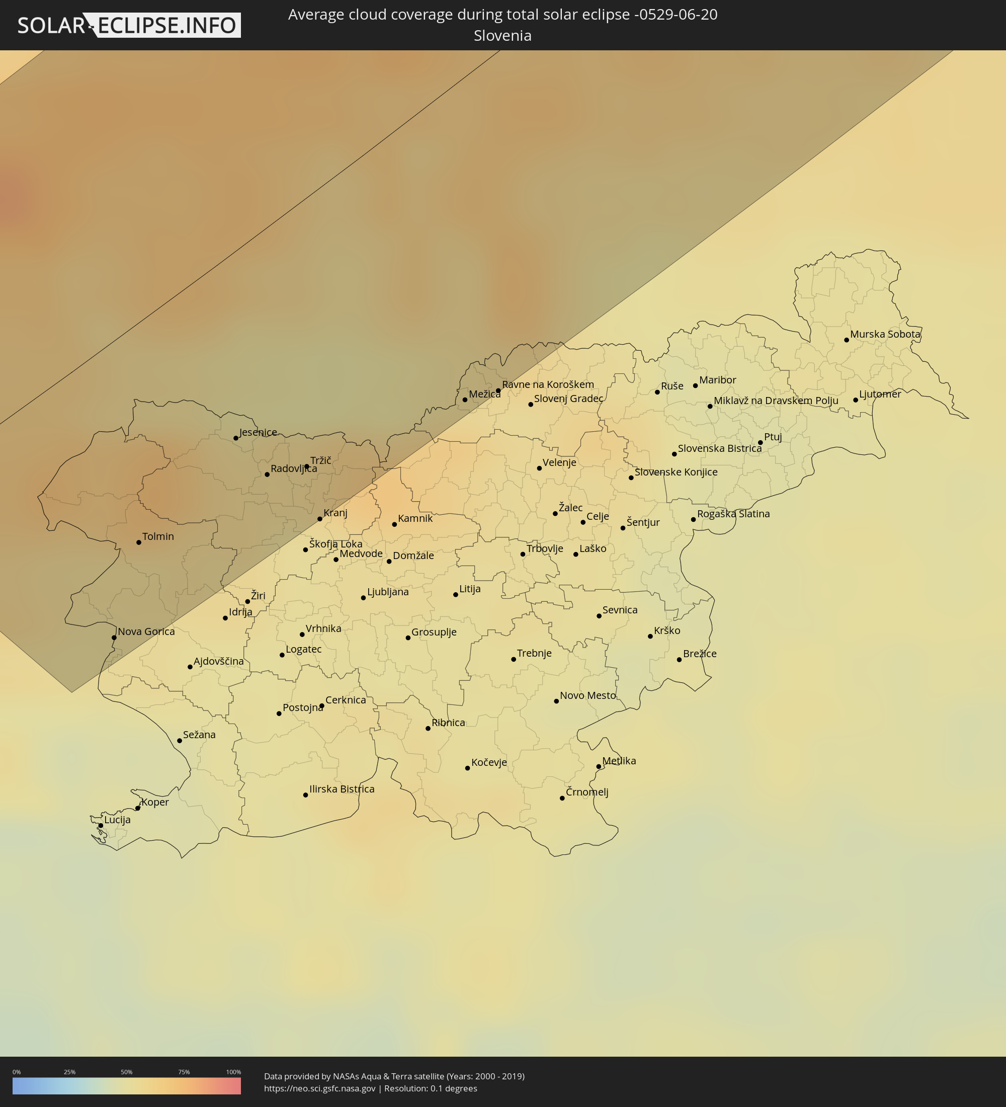
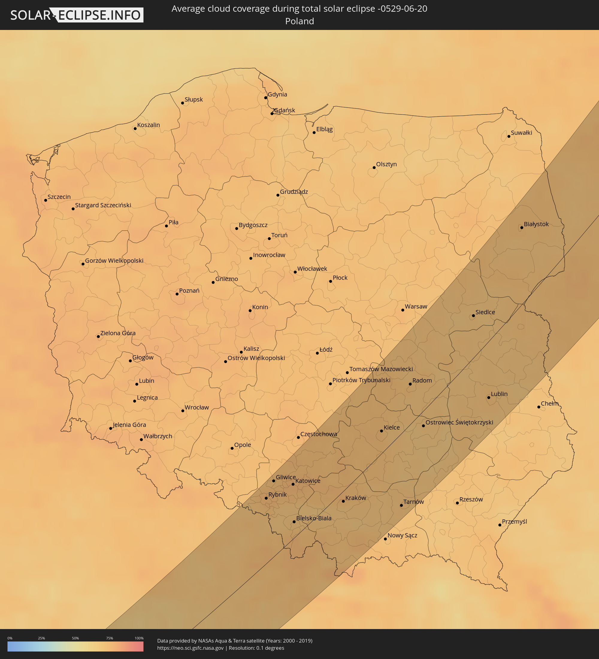
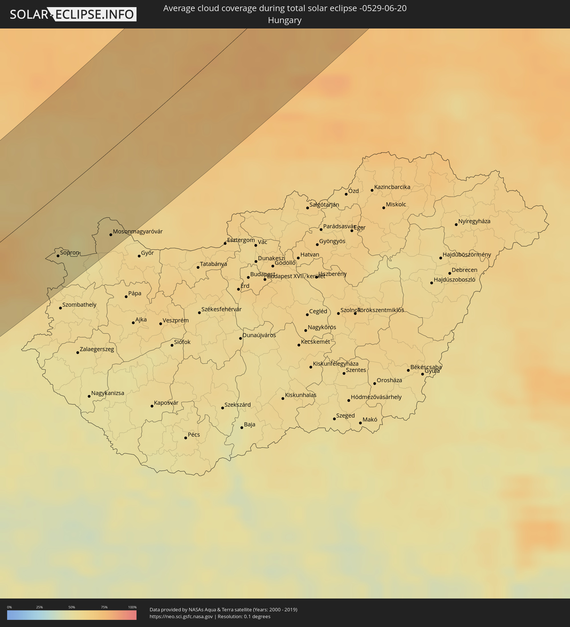
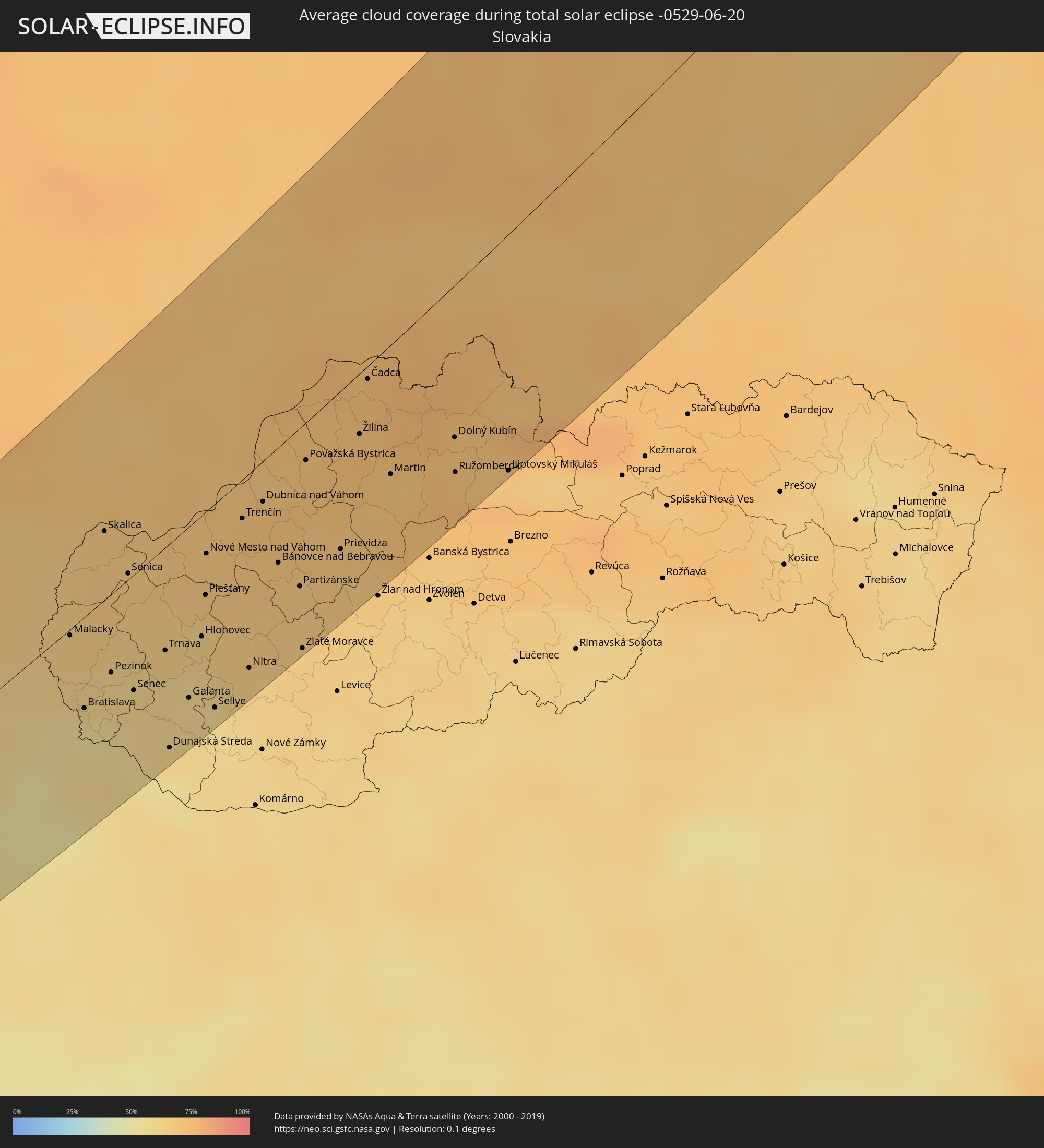
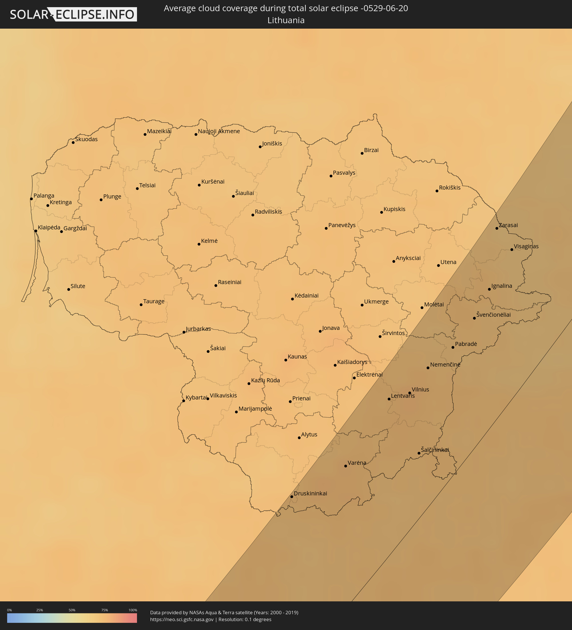
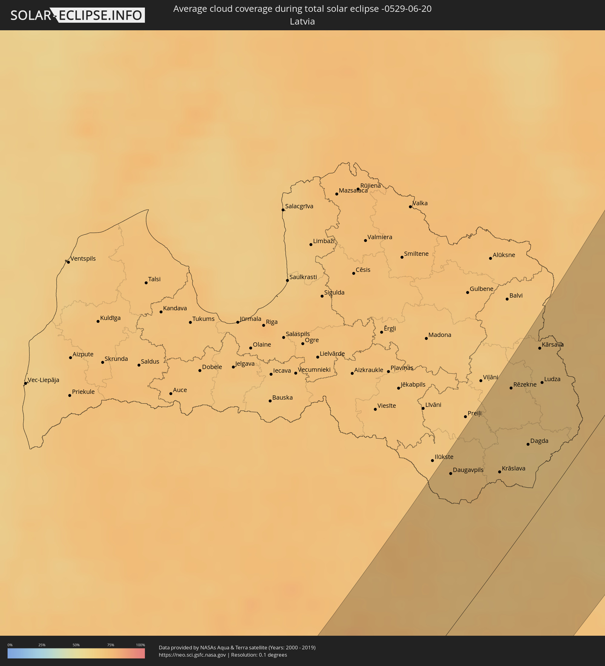
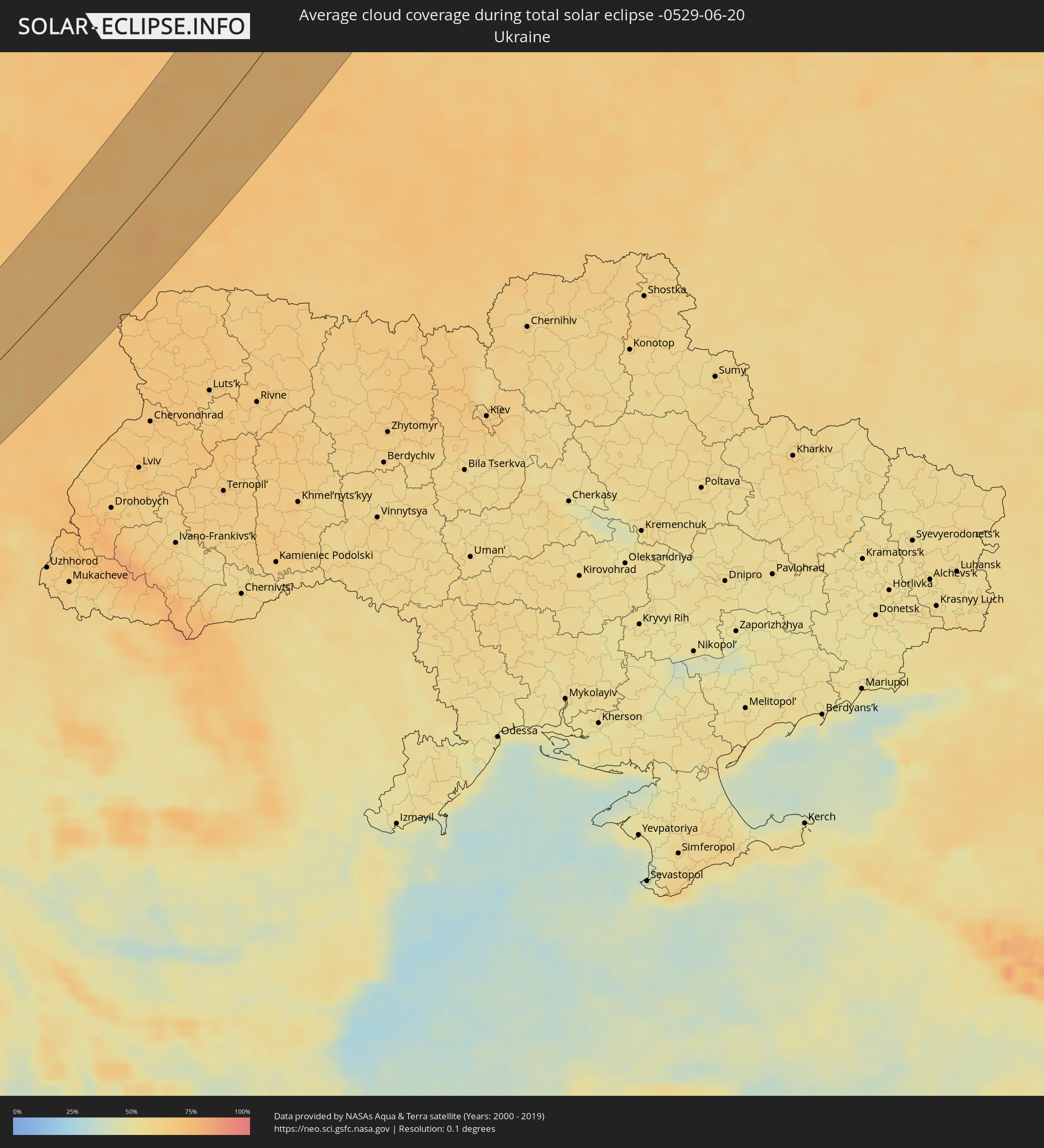
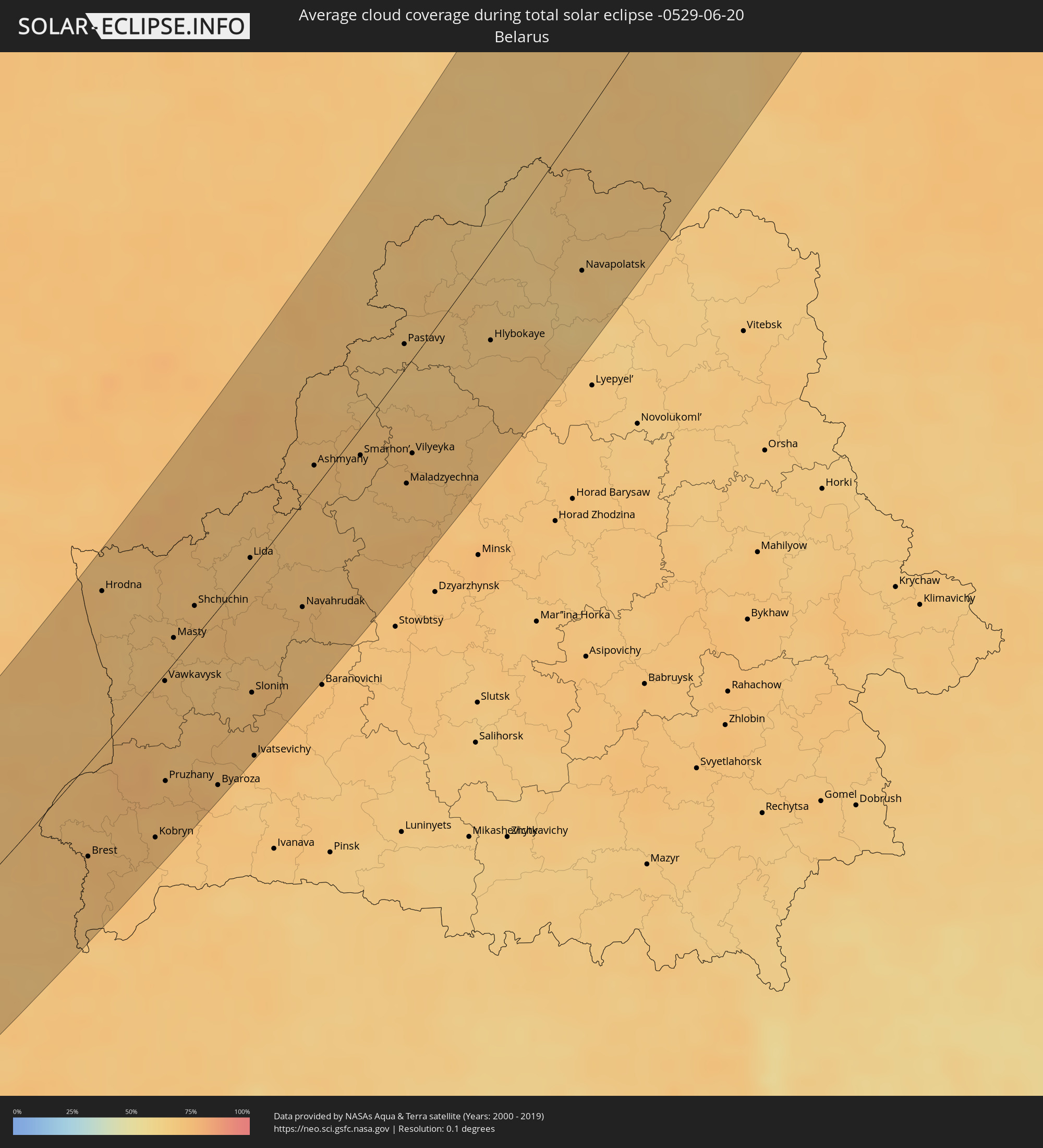
The following maps show the average cloud coverage for the day of the total solar eclipse.
With the help of these maps, it is possible to find the place along the eclipse path, which has the best
chance of a cloudless sky.
Nevertheless, you should consider local circumstances and inform about the weather of your chosen
observation site.
The data is provided by NASAs satellites
AQUA and TERRA.
The cloud maps are averaged over a period of 19 years (2000 - 2019).

Detailed country maps
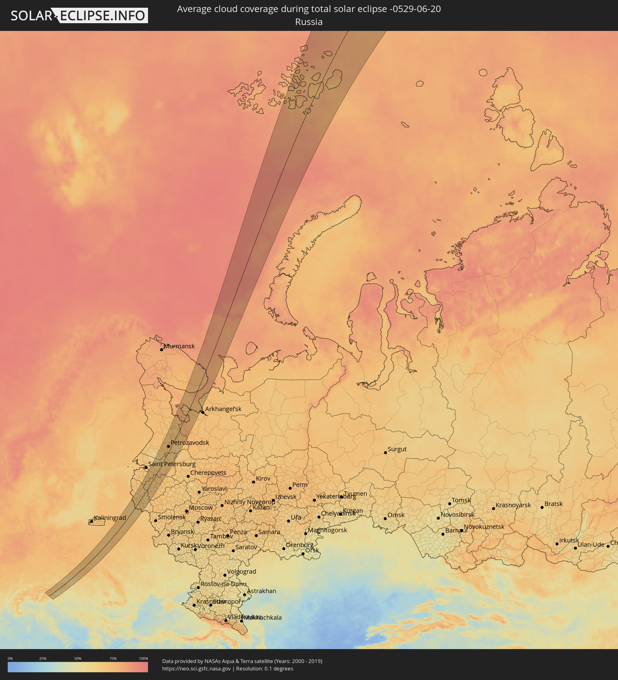 Russia
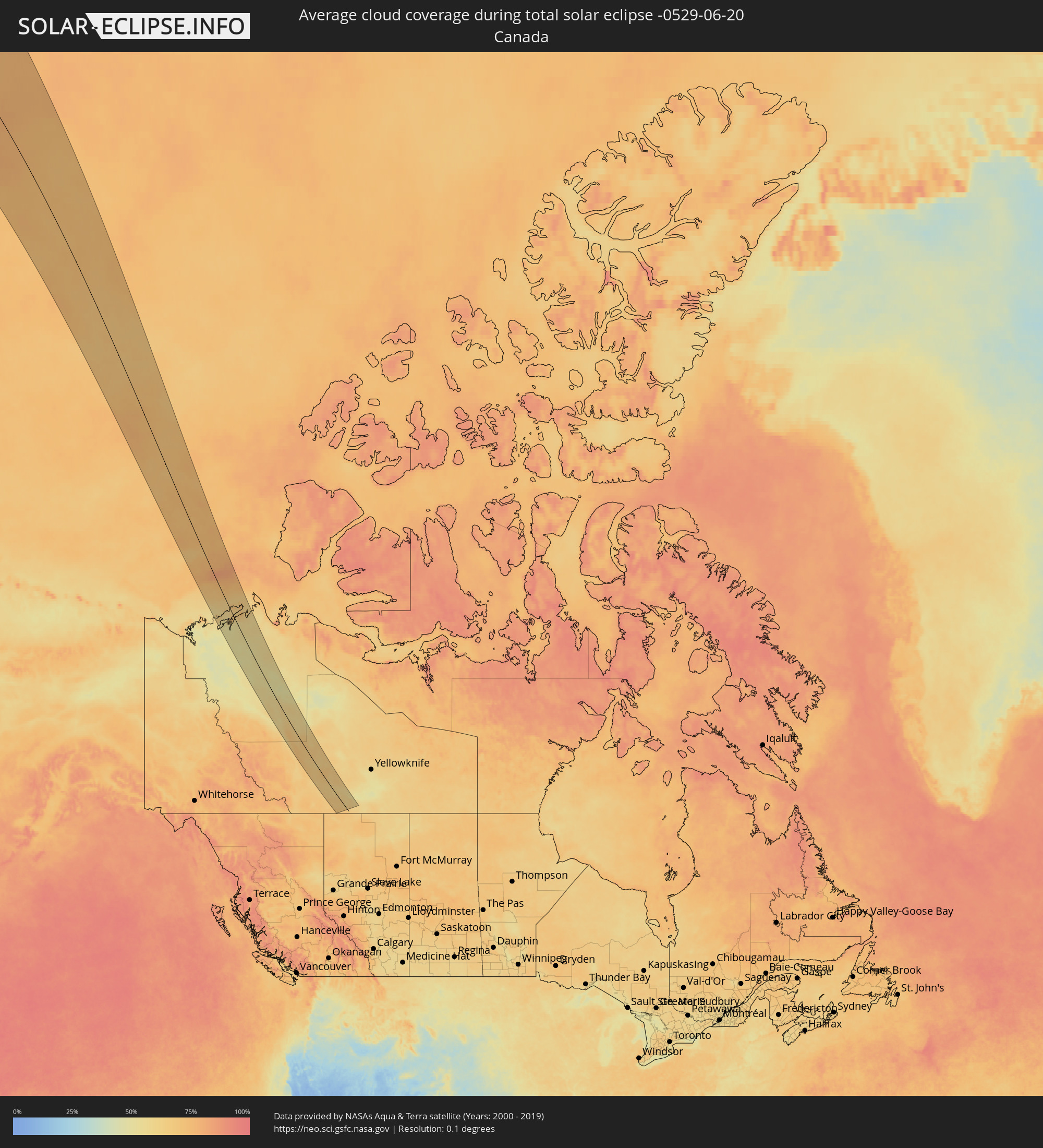 Canada
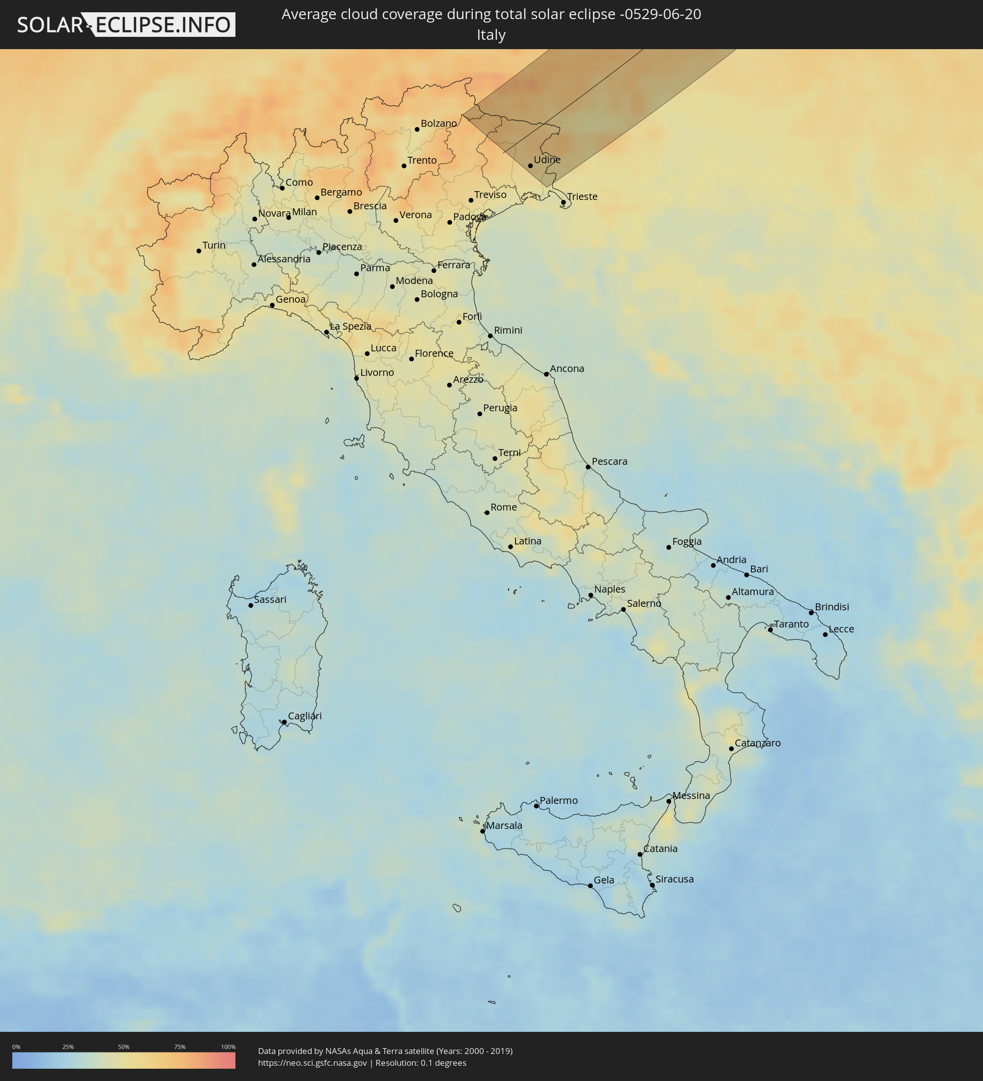 Italy
Italy
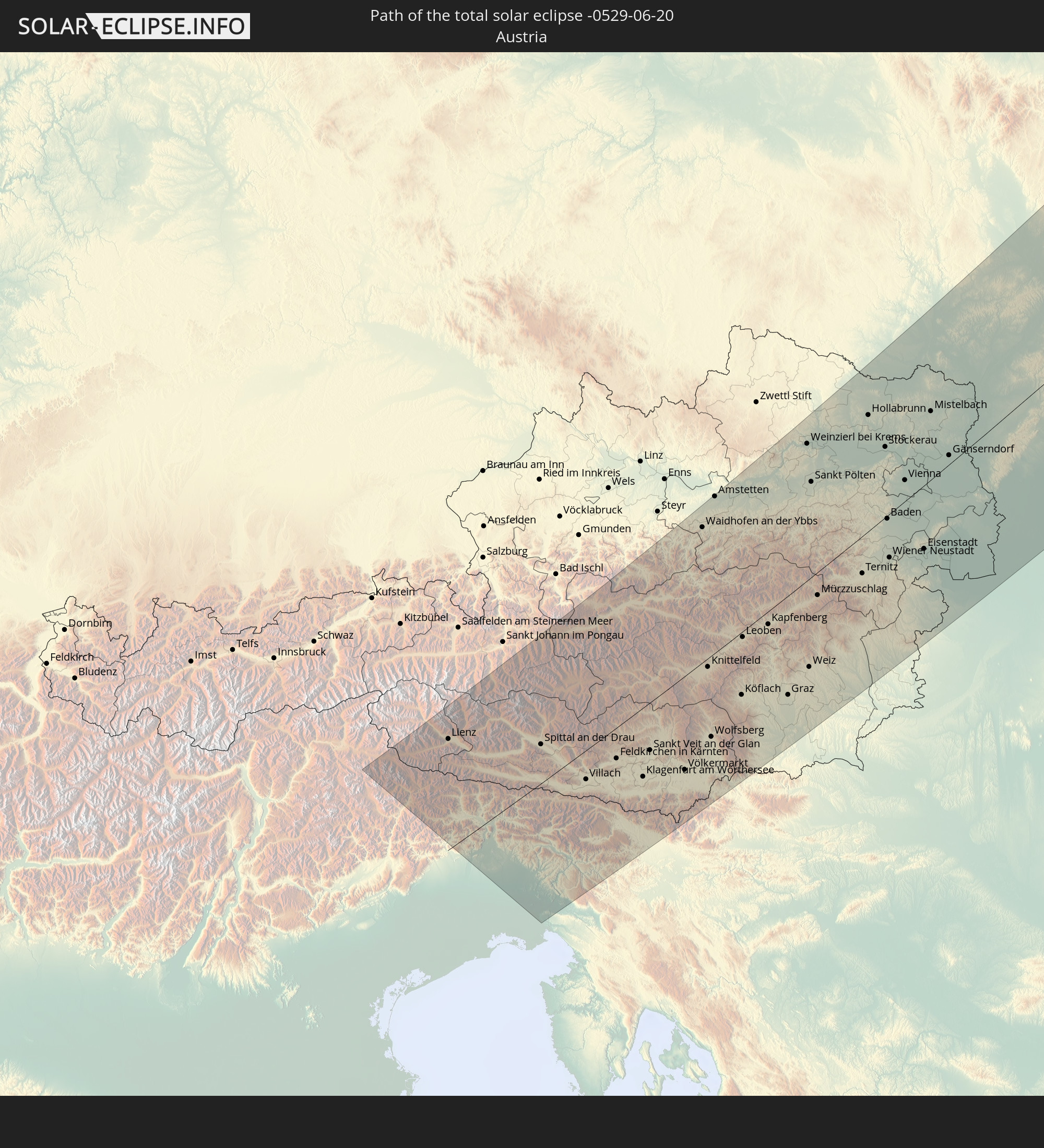
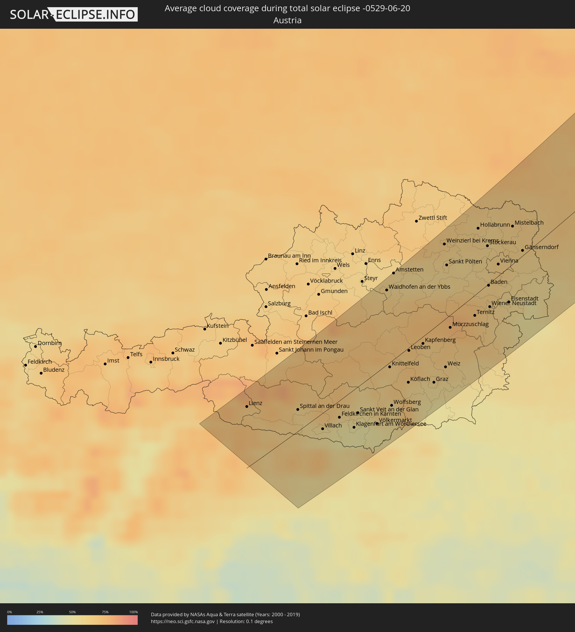 Austria
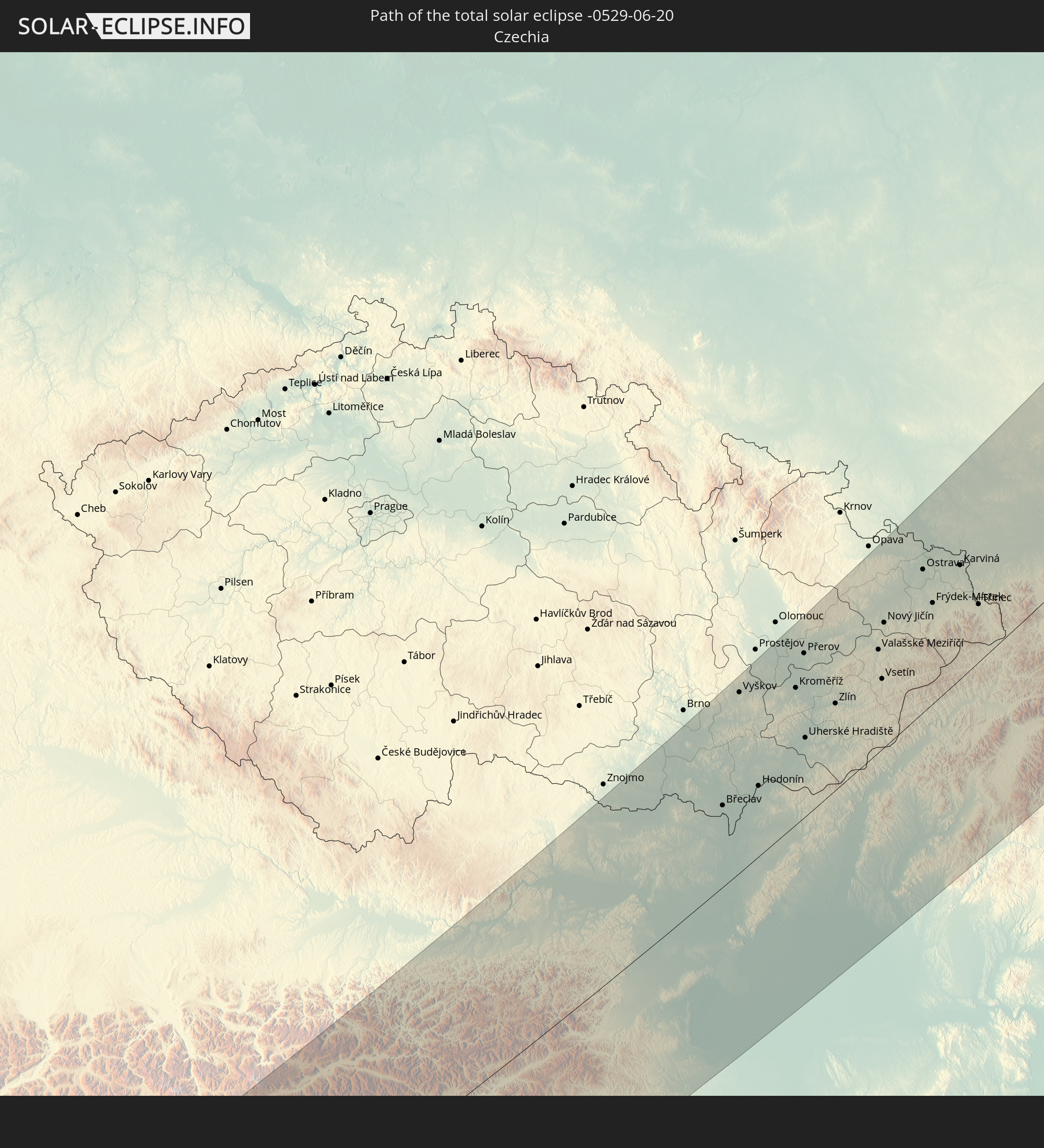
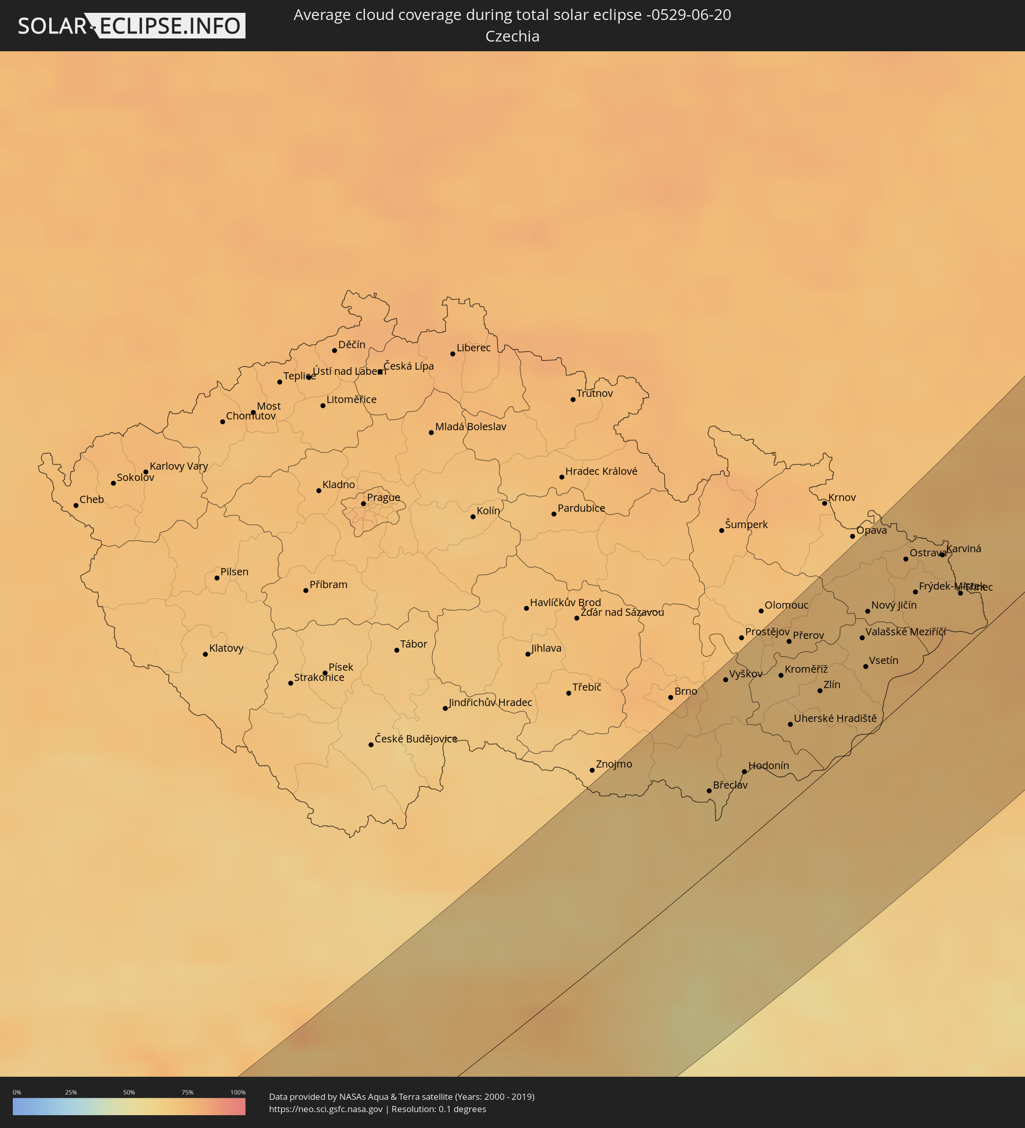 Czechia
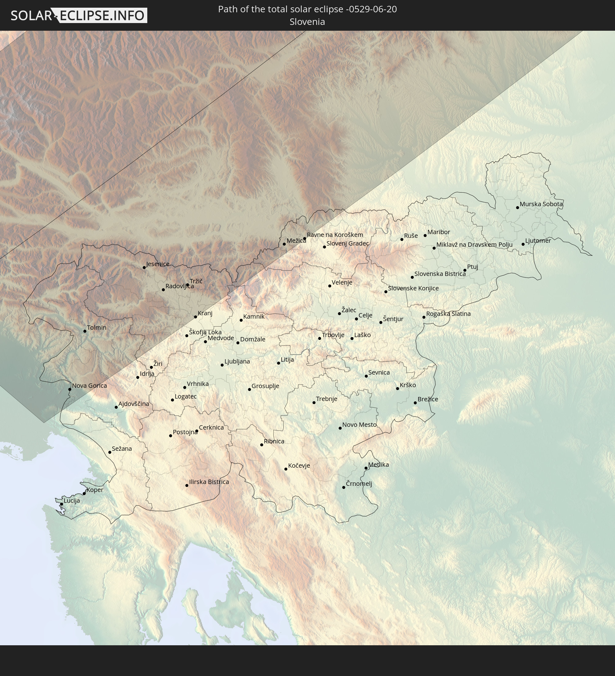
 Slovenia
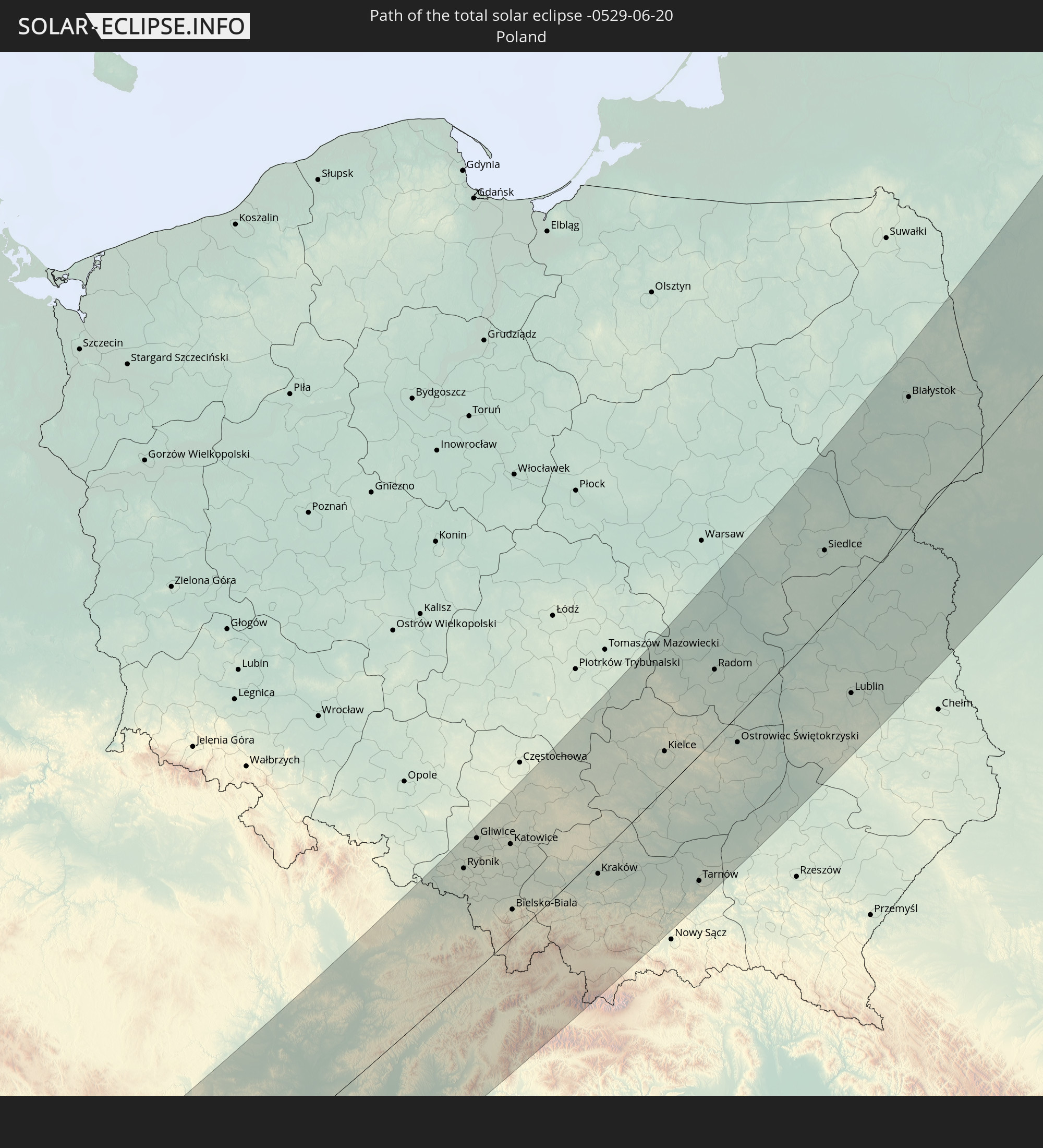
 Poland
 Hungary
 Slovakia
 Lithuania
 Latvia
 Ukraine
 Belarus
Cities inside the path of the eclipse
The following table shows all locations with a population of more than 5,000 inside the eclipse path. Cities which have more than 100,000 inhabitants are marked bold. A click at the locations opens a detailed map.
| City | Type | Eclipse duration | Local time of max. eclipse | Distance to central line | Ø Cloud coverage |
|
Lienz, Tyrol
|
total | - | 04:16:22 UTC+01:00 | 57 km | 69% |
|
San Daniele del Friuli, Friuli Venezia Giulia
|
total | - | 04:15:25 UTC+01:00 | 17 km | 61% |
|
Tolmezzo, Friuli Venezia Giulia
|
total | - | 04:15:42 UTC+01:00 | 7 km | 62% |
|
Majano, Friuli Venezia Giulia
|
total | - | 04:15:25 UTC+01:00 | 18 km | 59% |
|
Buia, Friuli Venezia Giulia
|
total | - | 04:15:25 UTC+01:00 | 17 km | 59% |
|
Gemona, Friuli Venezia Giulia
|
total | - | 04:15:29 UTC+01:00 | 12 km | 60% |
|
Martignacco, Friuli Venezia Giulia
|
total | - | 04:15:15 UTC+01:00 | 30 km | 56% |
|
Pasian di Prato, Friuli Venezia Giulia
|
total | - | 04:15:10 UTC+01:00 | 36 km | 53% |
|
Tarcento, Friuli Venezia Giulia
|
total | - | 04:15:21 UTC+01:00 | 22 km | 59% |
|
Tricesimo, Friuli Venezia Giulia
|
total | - | 04:15:18 UTC+01:00 | 26 km | 59% |
|
Tavagnacco, Friuli Venezia Giulia
|
total | - | 04:15:14 UTC+01:00 | 31 km | 58% |
|
Udine, Friuli Venezia Giulia
|
total | - | 04:15:10 UTC+01:00 | 35 km | 58% |
|
Manzano, Friuli Venezia Giulia
|
total | - | 04:15:00 UTC+01:00 | 49 km | 54% |
|
Cividale del Friuli, Friuli Venezia Giulia
|
total | - | 04:15:05 UTC+01:00 | 43 km | 57% |
|
Cormons, Friuli Venezia Giulia
|
total | - | 04:14:54 UTC+01:00 | 56 km | 52% |
|
Spittal an der Drau, Carinthia
|
total | - | 04:15:54 UTC+01:00 | 24 km | 63% |
|
Gradisca d'Isonzo, Friuli Venezia Giulia
|
total | - | 04:14:48 UTC+01:00 | 63 km | 48% |
|
Bovec, Bovec
|
total | - | 04:15:19 UTC+01:00 | 28 km | 63% |
|
Kobarid, Kobarid
|
total | - | 04:15:11 UTC+01:00 | 38 km | 55% |
|
Miren, Miren-Kostanjevica
|
total | - | 04:14:45 UTC+01:00 | 68 km | 47% |
|
Gorizia, Friuli Venezia Giulia
|
total | - | 04:14:48 UTC+01:00 | 65 km | 47% |
|
Kanal, Kanal
|
total | - | 04:14:58 UTC+01:00 | 57 km | 53% |
|
Nova Gorica, Nova Gorica
|
total | - | 04:14:48 UTC+01:00 | 66 km | 53% |
|
Tolmin, Tolmin
|
total | - | 04:15:01 UTC+01:00 | 49 km | 55% |
|
Kranjska Gora, Kranjska Gora
|
total | - | 04:15:20 UTC+01:00 | 26 km | 69% |
|
Villach, Carinthia
|
total | - | 04:15:28 UTC+01:00 | 27 km | 55% |
|
Bohinjska Bistrica, Bohinj
|
total | - | 04:15:00 UTC+01:00 | 49 km | 58% |
|
Cerkno, Cerkno
|
total | - | 04:14:49 UTC+01:00 | 63 km | 54% |
|
Jesenice, Jesenice
|
total | - | 04:15:08 UTC+01:00 | 46 km | 57% |
|
Feldkirchen in Kärnten, Carinthia
|
total | - | 04:15:29 UTC+01:00 | 15 km | 51% |
|
Žirovnica, Žirovnica
|
total | - | 04:15:04 UTC+01:00 | 50 km | 57% |
|
Železniki, Železniki
|
total | - | 04:14:50 UTC+01:00 | 64 km | 56% |
|
Klagenfurt am Wörthersee, Carinthia
|
total | - | 04:15:14 UTC+01:00 | 33 km | 49% |
|
Tržič, Tržič
|
total | - | 04:14:55 UTC+01:00 | 58 km | 57% |
|
Naklo, Naklo
|
total | - | 04:14:48 UTC+01:00 | 68 km | 53% |
|
Sankt Veit an der Glan, Carinthia
|
total | - | 04:15:23 UTC+01:00 | 29 km | 52% |
|
Preddvor, Preddvor
|
total | - | 04:14:46 UTC+01:00 | 68 km | 54% |
|
Zgornje Jezersko, Jezersko
|
total | - | 04:14:50 UTC+01:00 | 63 km | 65% |
|
Knittelfeld, Styria
|
total | - | 04:15:41 UTC+01:00 | 21 km | 63% |
|
Wolfsberg, Carinthia
|
total | - | 04:15:12 UTC+01:00 | 39 km | 56% |
|
Mežica, Mežica
|
total | - | 04:14:48 UTC+01:00 | 70 km | 61% |
|
Amstetten, Lower Austria
|
total | - | 04:16:48 UTC+01:00 | 73 km | 60% |
|
Prevalje, Prevalje
|
total | - | 04:14:48 UTC+01:00 | 69 km | 61% |
|
Dravograd, Dravograd
|
total | - | 04:14:48 UTC+01:00 | 69 km | 53% |
|
Leoben, Styria
|
total | - | 04:15:44 UTC+01:00 | 7 km | 66% |
|
Kapfenberg, Styria
|
total | - | 04:15:43 UTC+01:00 | 24 km | 64% |
|
Graz, Styria
|
total | - | 04:15:09 UTC+01:00 | 47 km | 56% |
|
Weinzierl bei Krems, Lower Austria
|
total | - | 04:16:46 UTC+01:00 | 62 km | 63% |
|
Sankt Pölten, Lower Austria
|
total | - | 04:16:29 UTC+01:00 | 44 km | 60% |
|
Ternitz, Lower Austria
|
total | - | 04:15:39 UTC+01:00 | 17 km | 70% |
|
Stockerau, Lower Austria
|
total | - | 04:16:25 UTC+01:00 | 32 km | 61% |
|
Baden, Lower Austria
|
total | - | 04:15:55 UTC+01:00 | 1 km | 66% |
|
Wiener Neustadt, Lower Austria
|
total | - | 04:15:39 UTC+01:00 | 20 km | 63% |
|
Vienna, Vienna
|
total | - | 04:16:07 UTC+01:00 | 10 km | 65% |
|
Kőszeg, Vas
|
total | - | 04:14:59 UTC+01:00 | 69 km | 58% |
|
Sopron, Győr-Moson-Sopron
|
total | - | 04:15:20 UTC+01:00 | 46 km | 54% |
|
Mikulov, South Moravian
|
total | - | 04:16:45 UTC+01:00 | 48 km | 67% |
|
Břeclav, South Moravian
|
total | - | 04:16:34 UTC+01:00 | 32 km | 64% |
|
Vyškov, South Moravian
|
total | - | 04:17:11 UTC+01:00 | 70 km | 70% |
|
Bratislava, Bratislavský
|
total | - | 04:15:40 UTC+01:00 | 31 km | 55% |
|
Kyjov, South Moravian
|
total | - | 04:16:47 UTC+01:00 | 42 km | 69% |
|
Hodonín, South Moravian
|
total | - | 04:16:34 UTC+01:00 | 28 km | 66% |
|
Jánossomorja, Győr-Moson-Sopron
|
total | - | 04:15:11 UTC+01:00 | 63 km | 56% |
|
Pezinok, Bratislavský
|
total | - | 04:15:46 UTC+01:00 | 26 km | 62% |
|
Mosonmagyaróvár, Győr-Moson-Sopron
|
total | - | 04:15:13 UTC+01:00 | 62 km | 59% |
|
Senica, Trnavský
|
total | - | 04:16:13 UTC+01:00 | 2 km | 67% |
|
Kroměříž, Zlín
|
total | - | 04:17:01 UTC+01:00 | 52 km | 67% |
|
Přerov, Olomoucký
|
total | - | 04:17:12 UTC+01:00 | 63 km | 71% |
|
Uherské Hradiště, Zlín
|
total | - | 04:16:41 UTC+01:00 | 30 km | 70% |
|
Trnava, Trnavský
|
total | - | 04:15:43 UTC+01:00 | 34 km | 65% |
|
Dunajská Streda, Trnavský
|
total | - | 04:15:12 UTC+01:00 | 68 km | 61% |
|
Zlín, Zlín
|
total | - | 04:16:48 UTC+01:00 | 33 km | 70% |
|
Bystřice pod Hostýnem, Zlín
|
total | - | 04:17:01 UTC+01:00 | 47 km | 71% |
|
Hranice, Olomoucký
|
total | - | 04:17:11 UTC+01:00 | 57 km | 70% |
|
Hlohovec, Trnavský
|
total | - | 04:15:41 UTC+01:00 | 40 km | 63% |
|
Piešťany, Trnavský
|
total | - | 04:15:53 UTC+01:00 | 27 km | 65% |
|
Nové Mesto nad Váhom, Trenčiansky
|
total | - | 04:16:06 UTC+01:00 | 14 km | 69% |
|
Sellye, Nitriansky
|
total | - | 04:15:16 UTC+01:00 | 67 km | 59% |
|
Vsetín, Zlín
|
total | - | 04:16:47 UTC+01:00 | 27 km | 70% |
|
Nový Jičín, Moravskoslezský
|
total | - | 04:17:07 UTC+01:00 | 47 km | 70% |
|
Trenčín, Trenčiansky
|
total | - | 04:16:10 UTC+01:00 | 13 km | 70% |
|
Studénka
|
total | - | 04:17:16 UTC+01:00 | 54 km | 69% |
|
Nitra, Nitriansky
|
total | - | 04:15:23 UTC+01:00 | 64 km | 63% |
|
Rožnov pod Radhoštěm, Zlín
|
total | - | 04:16:52 UTC+01:00 | 29 km | 71% |
|
Racibórz, Silesian Voivodeship
|
total | - | 04:41:41 UTC+01:24 | 77 km | 71% |
|
Ostrava, Moravskoslezský
|
total | - | 04:17:19 UTC+01:00 | 57 km | 72% |
|
Frýdek-Místek, Moravskoslezský
|
total | - | 04:17:05 UTC+01:00 | 38 km | 72% |
|
Partizánske, Nitriansky
|
total | - | 04:15:39 UTC+01:00 | 51 km | 67% |
|
Považská Bystrica, Trenčiansky
|
total | - | 04:16:17 UTC+01:00 | 12 km | 71% |
|
Karviná, Moravskoslezský
|
total | - | 04:17:13 UTC+01:00 | 43 km | 71% |
|
Rybnik, Silesian Voivodeship
|
total | - | 04:41:33 UTC+01:24 | 63 km | 75% |
|
Jastrzębie Zdrój, Silesian Voivodeship
|
total | - | 04:41:20 UTC+01:24 | 49 km | 73% |
|
Prievidza, Nitriansky
|
total | - | 04:15:44 UTC+01:00 | 51 km | 70% |
|
Třinec, Moravskoslezský
|
total | - | 04:16:55 UTC+01:00 | 25 km | 72% |
|
Gliwice, Silesian Voivodeship
|
total | - | 04:41:45 UTC+01:24 | 71 km | 75% |
|
Žilina, Žilinský
|
total | - | 04:16:17 UTC+01:00 | 19 km | 73% |
|
Čadca, Žilinský
|
total | - | 04:16:32 UTC+01:00 | 25 km | 75% |
|
Tarnowskie Góry, Silesian Voivodeship
|
total | - | 04:41:52 UTC+01:24 | 74 km | 75% |
|
Martin, Žilinský
|
total | - | 04:15:59 UTC+01:00 | 41 km | 71% |
|
Katowice, Silesian Voivodeship
|
total | - | 04:41:33 UTC+01:24 | 51 km | 76% |
|
Bielsko-Biala, Silesian Voivodeship
|
total | - | 04:40:56 UTC+01:24 | 24 km | 74% |
|
Dąbrowa Górnicza, Silesian Voivodeship
|
total | - | 04:41:32 UTC+01:24 | 45 km | 77% |
|
Ružomberok, Žilinský
|
total | - | 04:15:48 UTC+01:00 | 64 km | 72% |
|
Liptovský Mikuláš, Žilinský
|
total | - | 04:15:40 UTC+01:00 | 74 km | 70% |
|
Kraków, Lesser Poland Voivodeship
|
total | - | 04:40:52 UTC+01:24 | 10 km | 73% |
|
Kielce, Świętokrzyskie
|
total | - | 04:41:41 UTC+01:24 | 20 km | 75% |
|
Tarnów, Lesser Poland Voivodeship
|
total | - | 04:40:20 UTC+01:24 | 66 km | 71% |
|
Radom, Masovian Voivodeship
|
total | - | 04:42:13 UTC+01:24 | 35 km | 73% |
|
Ostrowiec Świętokrzyski, Świętokrzyskie
|
total | - | 04:41:27 UTC+01:24 | 14 km | 69% |
|
Mielec, Subcarpathian Voivodeship
|
total | - | 04:40:32 UTC+01:24 | 66 km | 69% |
|
Stalowa Wola, Subcarpathian Voivodeship
|
total | - | 04:40:41 UTC+01:24 | 77 km | 72% |
|
Siedlce, Masovian Voivodeship
|
total | - | 04:42:51 UTC+01:24 | 35 km | 70% |
|
Lublin, Lublin Voivodeship
|
total | - | 04:41:25 UTC+01:24 | 48 km | 73% |
|
Biała Podlaska, Lublin Voivodeship
|
total | - | 04:42:20 UTC+01:24 | 17 km | 71% |
|
Białystok, Podlasie
|
total | - | 04:43:56 UTC+01:24 | 61 km | 70% |
|
Brest, Brest
|
total | - | 05:08:13 UTC+01:50 | 41 km | 73% |
|
Hrodna, Grodnenskaya
|
total | - | 05:10:31 UTC+01:50 | 66 km | 72% |
|
Druskininkai, Alytus County
|
total | - | 04:44:58 UTC+01:24 | 82 km | 72% |
|
Kobryn, Brest
|
total | - | 05:08:09 UTC+01:50 | 68 km | 73% |
|
Vawkavysk, Grodnenskaya
|
total | - | 05:09:31 UTC+01:50 | 3 km | 72% |
|
Pruzhany, Brest
|
total | - | 05:08:37 UTC+01:50 | 47 km | 74% |
|
Masty, Grodnenskaya
|
total | - | 05:09:52 UTC+01:50 | 10 km | 71% |
|
Varėna, Alytus County
|
total | - | 04:45:04 UTC+01:24 | 65 km | 74% |
|
Shchuchin, Grodnenskaya
|
total | - | 05:10:05 UTC+01:50 | 17 km | 72% |
|
Trakai
|
total | - | 04:45:36 UTC+01:24 | 75 km | 73% |
|
Byaroza, Brest
|
total | - | 05:08:24 UTC+01:50 | 75 km | 72% |
|
Lentvaris, Vilnius County
|
total | - | 04:45:34 UTC+01:24 | 70 km | 74% |
|
Grigiškės
|
total | - | 04:45:37 UTC+01:24 | 70 km | 74% |
|
Pilaitė, Vilnius County
|
total | - | 04:45:36 UTC+01:24 | 66 km | 75% |
|
Justiniškės, Vilnius County
|
total | - | 04:45:37 UTC+01:24 | 66 km | 75% |
|
Vilkpėdė, Vilnius County
|
total | - | 04:45:32 UTC+01:24 | 61 km | 75% |
|
Naujamiestis, Vilnius County
|
total | - | 04:45:33 UTC+01:24 | 61 km | 75% |
|
Vilnius, Vilnius County
|
total | - | 04:45:34 UTC+01:24 | 61 km | 75% |
|
Lida, Grodnenskaya
|
total | - | 05:10:19 UTC+01:50 | 5 km | 71% |
|
Rasos, Vilnius County
|
total | - | 04:45:32 UTC+01:24 | 58 km | 75% |
|
Slonim, Grodnenskaya
|
total | - | 05:09:07 UTC+01:50 | 52 km | 72% |
|
Ivatsevichy, Brest
|
total | - | 05:08:32 UTC+01:50 | 81 km | 72% |
|
Šalčininkai
|
total | - | 04:44:56 UTC+01:24 | 29 km | 72% |
|
Nemenčinė, Vilnius County
|
total | - | 04:45:45 UTC+01:24 | 61 km | 73% |
|
Pabradė, Vilnius County
|
total | - | 04:45:52 UTC+01:24 | 56 km | 70% |
|
Navahrudak, Grodnenskaya
|
total | - | 05:09:43 UTC+01:50 | 42 km | 73% |
|
Ashmyany, Grodnenskaya
|
total | - | 05:10:57 UTC+01:50 | 9 km | 72% |
|
Švenčionėliai
|
total | - | 04:46:05 UTC+01:24 | 56 km | 72% |
|
Švenčionys, Vilnius County
|
total | - | 04:45:59 UTC+01:24 | 45 km | 71% |
|
Ignalina
|
total | - | 04:46:19 UTC+01:24 | 60 km | 72% |
|
Zarasai, Utena County
|
total | - | 04:46:53 UTC+01:24 | 80 km | 69% |
|
Smarhon’, Grodnenskaya
|
total | - | 05:10:54 UTC+01:50 | 11 km | 70% |
|
Visaginas, Utena County
|
total | - | 04:46:38 UTC+01:24 | 67 km | 68% |
|
Daugavpils, Daugavpils municipality
|
total | - | 04:59:37 UTC+01:36 | 75 km | 68% |
|
Pastavy, Vitebsk
|
total | - | 05:11:45 UTC+01:50 | 11 km | 68% |
|
Maladzyechna, Minsk
|
total | - | 05:10:30 UTC+01:50 | 45 km | 72% |
|
Vilyeyka, Minsk
|
total | - | 05:10:45 UTC+01:50 | 36 km | 73% |
|
Aglona, Aglona
|
total | - | 04:59:52 UTC+01:36 | 66 km | 67% |
|
Krāslava, Krāslavas Rajons
|
total | - | 04:59:27 UTC+01:36 | 43 km | 69% |
|
Rēzekne, Rēzekne
|
total | - | 05:00:22 UTC+01:36 | 77 km | 67% |
|
Dagda, Dagda
|
total | - | 04:59:40 UTC+01:36 | 37 km | 64% |
|
Baltinava, Baltinava
|
total | - | 05:01:00 UTC+01:36 | 87 km | 69% |
|
Kārsava, Karsava
|
total | - | 05:00:44 UTC+01:36 | 75 km | 67% |
|
Hlybokaye, Vitebsk
|
total | - | 05:11:33 UTC+01:50 | 33 km | 68% |
|
Ludza, Ludzas Rajons
|
total | - | 05:00:20 UTC+01:36 | 56 km | 67% |
|
Cibla, Cibla
|
total | - | 05:00:18 UTC+01:36 | 48 km | 66% |
|
Zilupe, Zilupes
|
total | - | 04:59:59 UTC+01:36 | 26 km | 67% |
|
Ostrov, Pskov
|
total | - | 05:55:11 UTC+02:30 | 72 km | 70% |
|
Navapolatsk, Vitebsk
|
total | - | 05:11:56 UTC+01:50 | 53 km | 68% |
|
Luga, Leningradskaya Oblast'
|
total | - | 05:57:09 UTC+02:30 | 79 km | 70% |
|
Otradnoye, Leningradskaya Oblast'
|
total | - | 05:58:43 UTC+02:30 | 90 km | 71% |
|
Tosno, Leningradskaya Oblast'
|
total | - | 05:58:18 UTC+02:30 | 72 km | 71% |
|
Kirovsk, Leningradskaya Oblast'
|
total | - | 05:58:51 UTC+02:30 | 87 km | 69% |
|
Velikiy Novgorod, Novgorod
|
total | - | 05:56:31 UTC+02:30 | 23 km | 68% |
|
Staraya Russa, Novgorod
|
total | - | 05:55:37 UTC+02:30 | 47 km | 68% |
|
Chudovo, Novgorod
|
total | - | 05:57:27 UTC+02:30 | 23 km | 70% |
|
Kirishi, Leningradskaya Oblast'
|
total | - | 05:57:57 UTC+02:30 | 23 km | 72% |
|
Volkhov, Leningradskaya Oblast'
|
total | - | 05:58:43 UTC+02:30 | 29 km | 70% |
|
Tikhvin, Leningradskaya Oblast'
|
total | - | 05:58:03 UTC+02:30 | 58 km | 72% |
|
Lodeynoye Pole, Leningradskaya Oblast'
|
total | - | 05:59:55 UTC+02:30 | 17 km | 69% |
|
Boksitogorsk, Leningradskaya Oblast'
|
total | - | 05:57:43 UTC+02:30 | 79 km | 72% |
|
Podporozh’ye, Leningradskaya Oblast'
|
total | - | 06:00:10 UTC+02:30 | 16 km | 70% |
|
Kondopoga, Republic of Karelia
|
total | - | 06:02:26 UTC+02:30 | 48 km | 73% |
|
Petrozavodsk, Republic of Karelia
|
total | - | 06:01:41 UTC+02:30 | 34 km | 73% |
|
Medvezh’yegorsk, Republic of Karelia
|
total | - | 06:03:41 UTC+02:30 | 77 km | 71% |
|
Onega, Arkhangelskaya
|
total | - | 06:05:13 UTC+02:30 | 52 km | 75% |
|
Severodvinsk, Arkhangelskaya
|
total | - | 06:06:23 UTC+02:30 | 90 km | 72% |