Total solar eclipse of 03/24/-0692
| Day of week: | Thursday |
| Maximum duration of eclipse: | 04m42s |
| Maximum width of eclipse path: | 313 km |
| Saros cycle: | 57 |
| Coverage: | 100% |
| Magnitude: | 1.0664 |
| Gamma: | 0.7332 |
Wo kann man die Sonnenfinsternis vom 03/24/-0692 sehen?
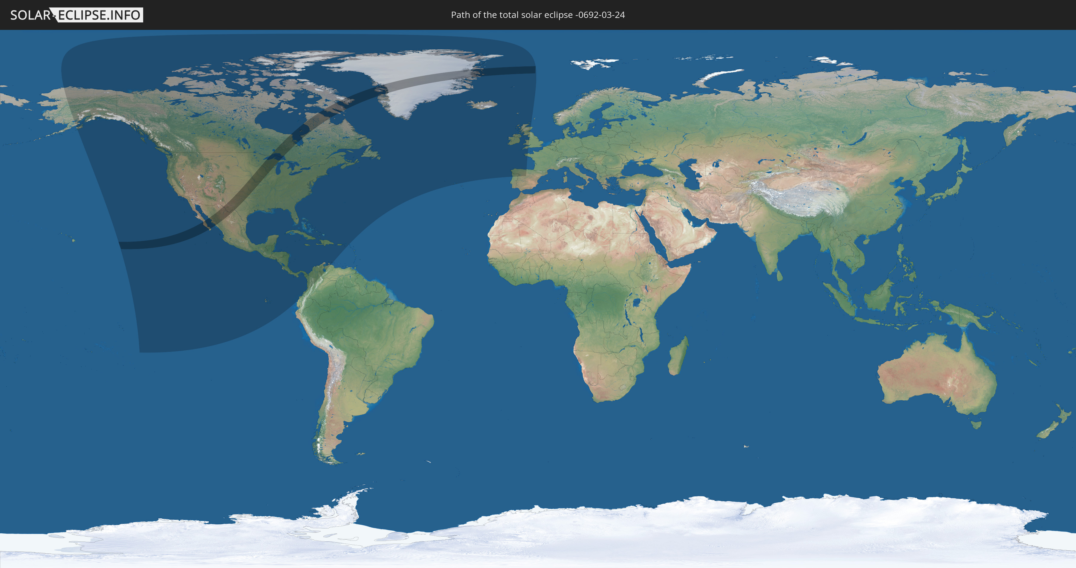
Die Sonnenfinsternis am 03/24/-0692 kann man in 38 Ländern als partielle Sonnenfinsternis beobachten.
Der Finsternispfad verläuft durch 4 Länder. Nur in diesen Ländern ist sie als total Sonnenfinsternis zu sehen.
In den folgenden Ländern ist die Sonnenfinsternis total zu sehen
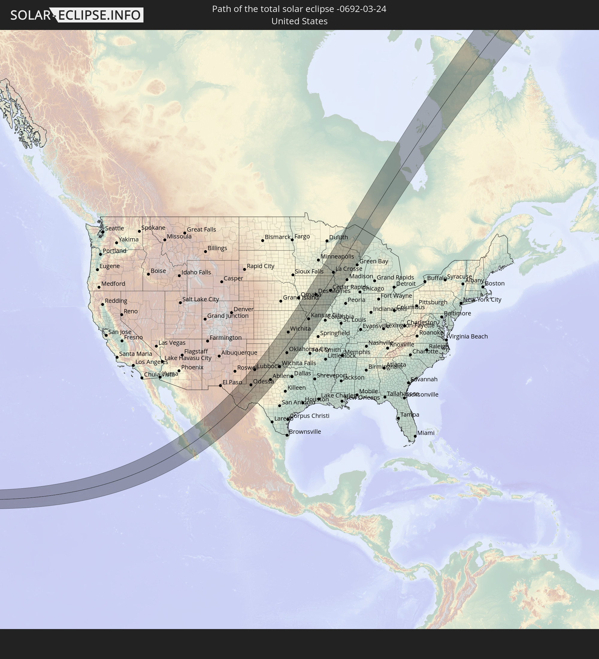 United States
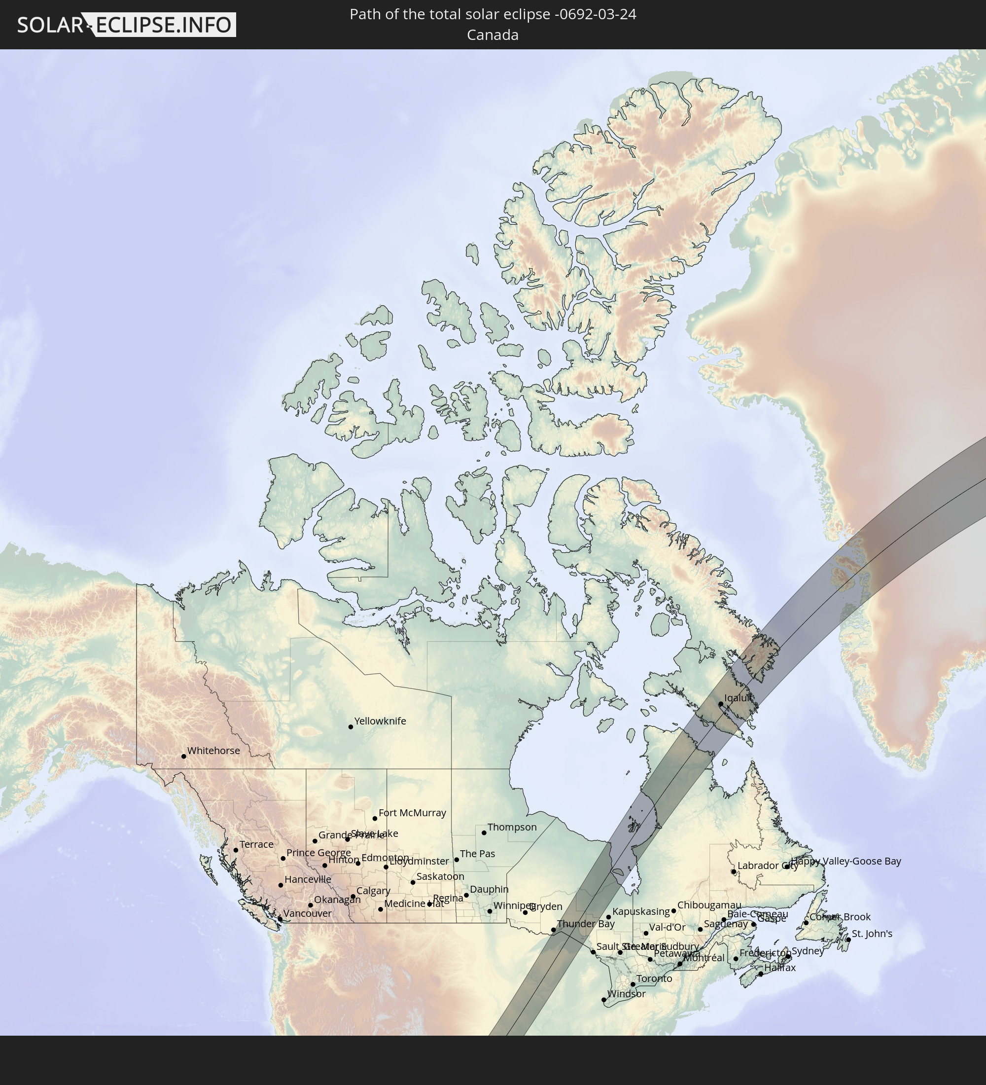 Canada
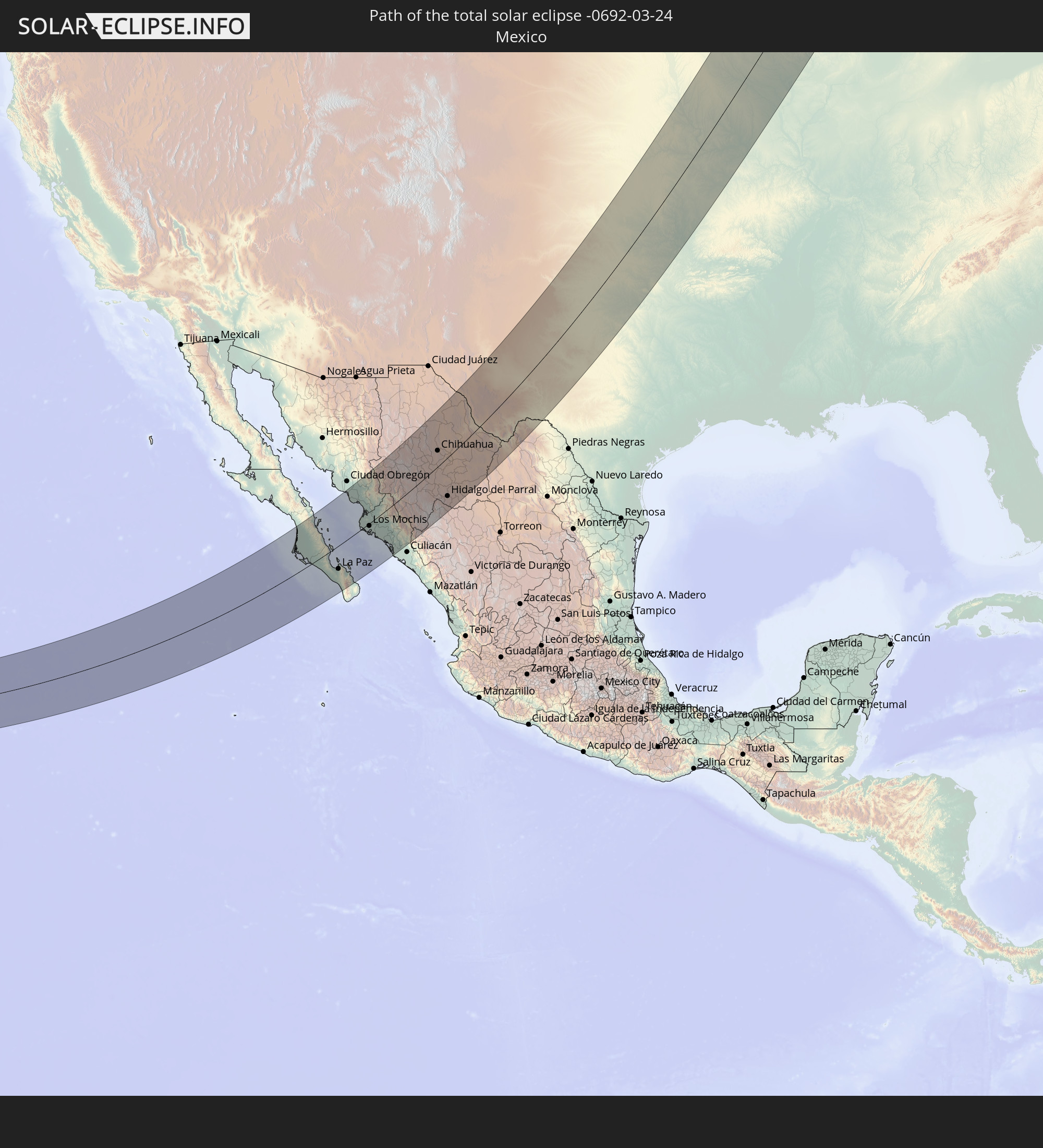 Mexico
 Greenland
In den folgenden Ländern ist die Sonnenfinsternis partiell zu sehen
 United States
 United States Minor Outlying Islands
 Canada
 Mexico
 Greenland
 Guatemala
 Ecuador
 El Salvador
 Honduras
 Belize
 Nicaragua
 Costa Rica
 Cuba
Cuba
 Panama
 Colombia
 Cayman Islands
 The Bahamas
 Jamaica
 Haiti
Haiti
 Venezuela
 Turks and Caicos Islands
 Dominican Republic
 Aruba
Aruba
 Puerto Rico
 United States Virgin Islands
 Bermuda
 British Virgin Islands
 Anguilla
 Saint Pierre and Miquelon
 Portugal
 Iceland
 Spain
Spain
 Republic of Ireland
 Svalbard and Jan Mayen
 United Kingdom
 Faroe Islands
 France
 Isle of Man
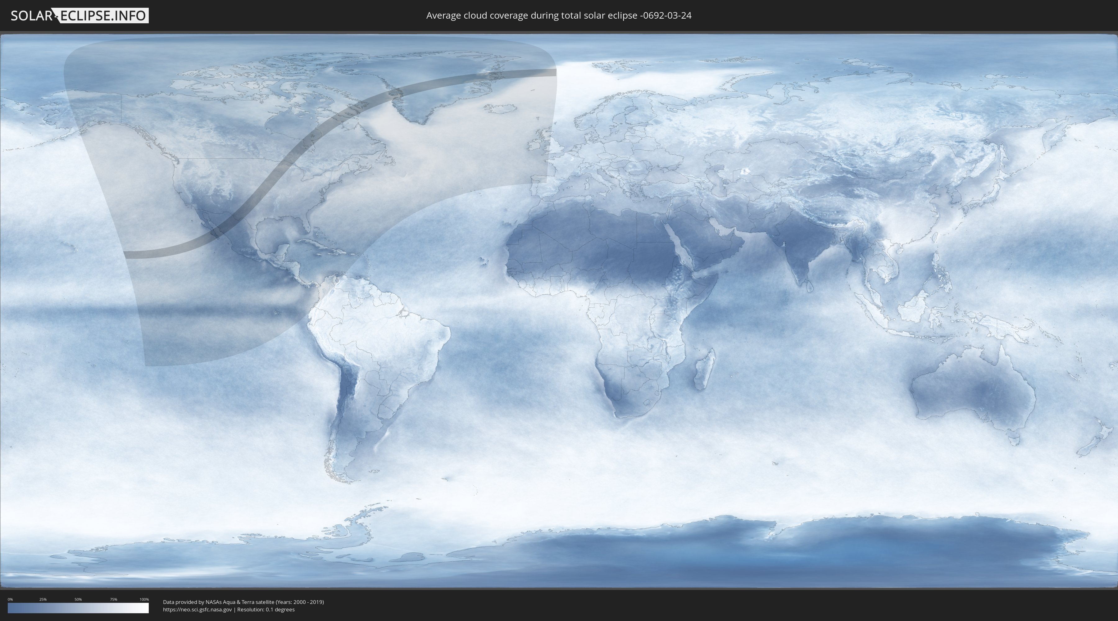
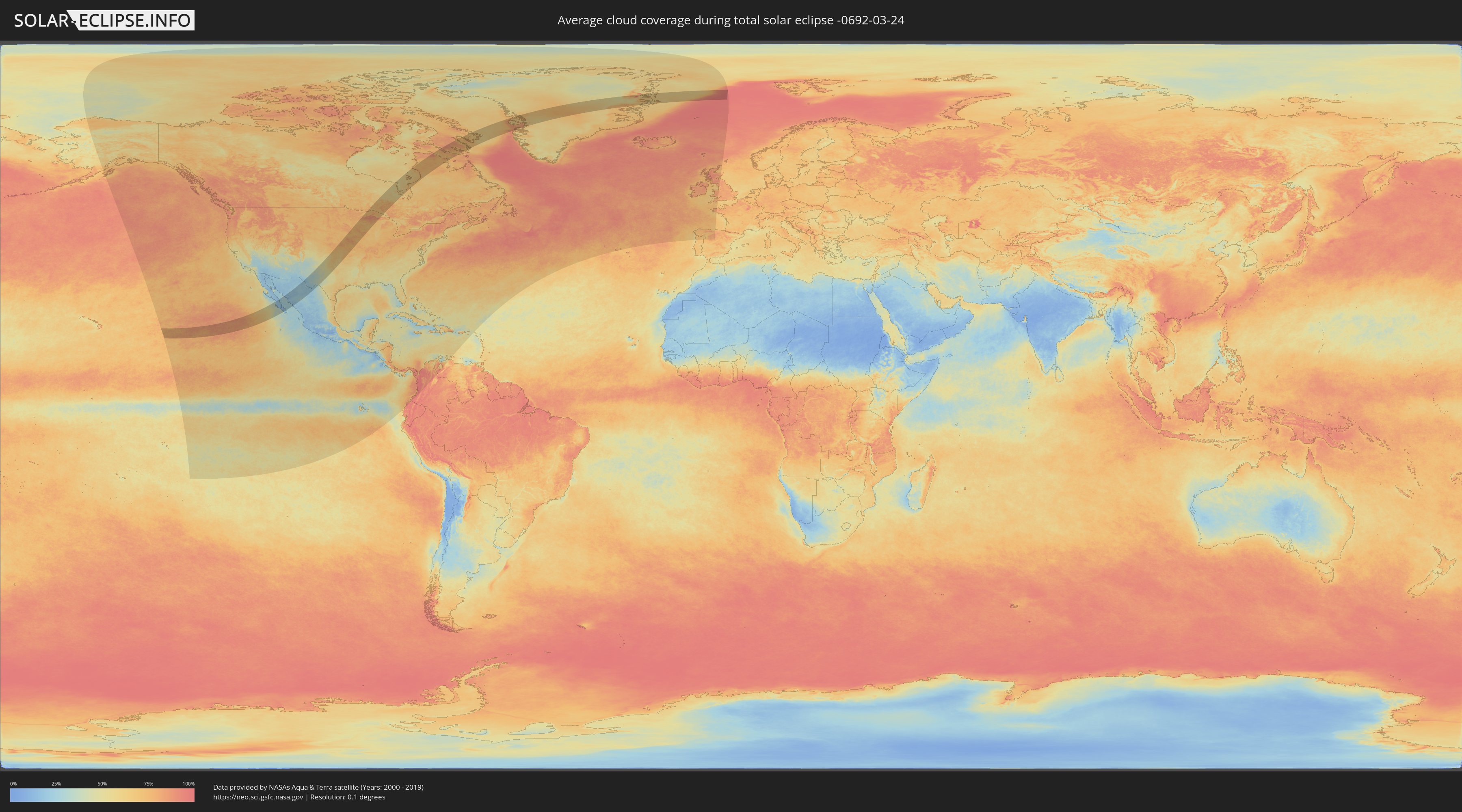
How will be the weather during the total solar eclipse on 03/24/-0692?
Where is the best place to see the total solar eclipse of 03/24/-0692?
The following maps show the average cloud coverage for the day of the total solar eclipse.
With the help of these maps, it is possible to find the place along the eclipse path, which has the best
chance of a cloudless sky.
Nevertheless, you should consider local circumstances and inform about the weather of your chosen
observation site.
The data is provided by NASAs satellites
AQUA and TERRA.
The cloud maps are averaged over a period of 19 years (2000 - 2019).
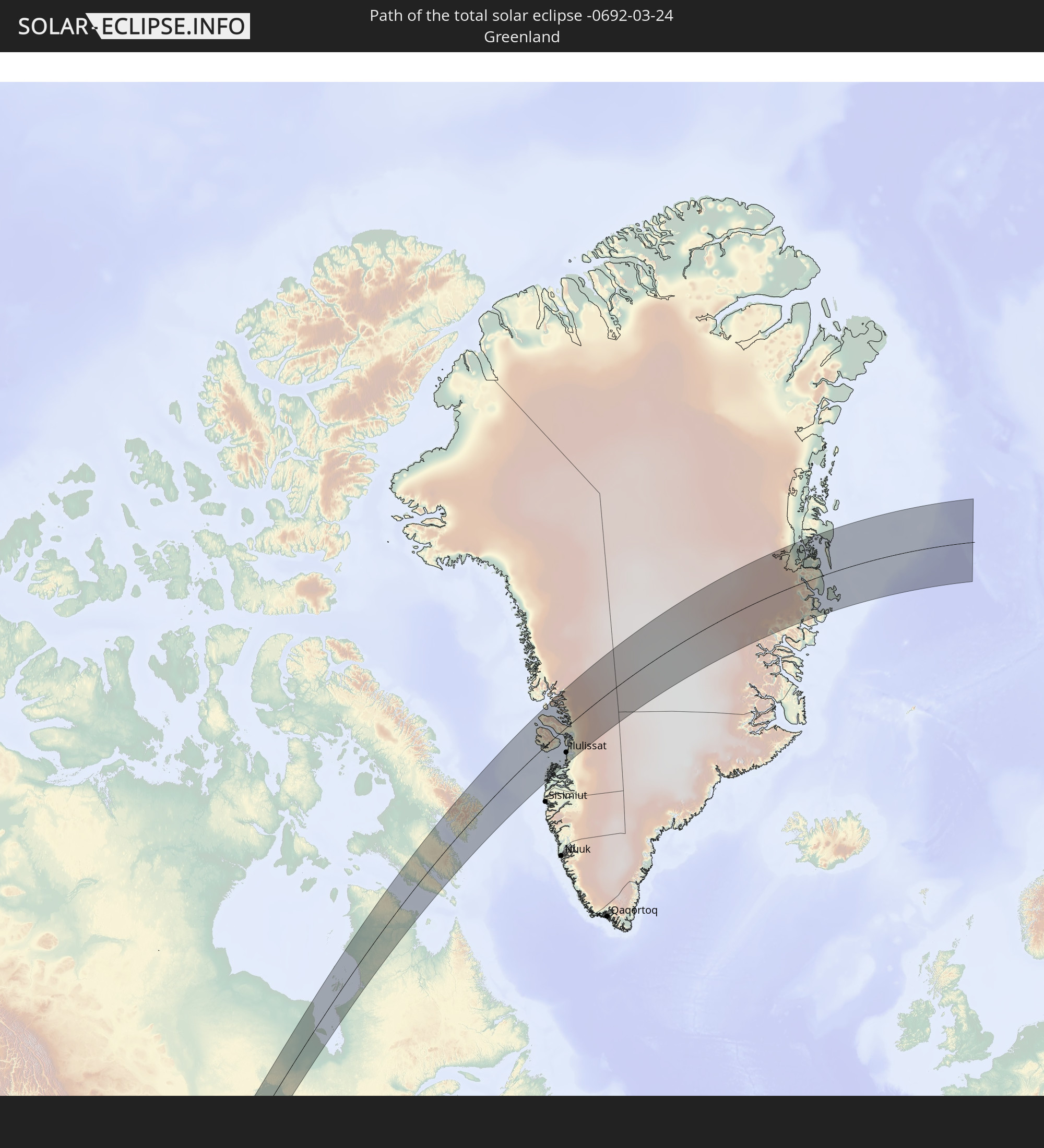
Detailed country maps
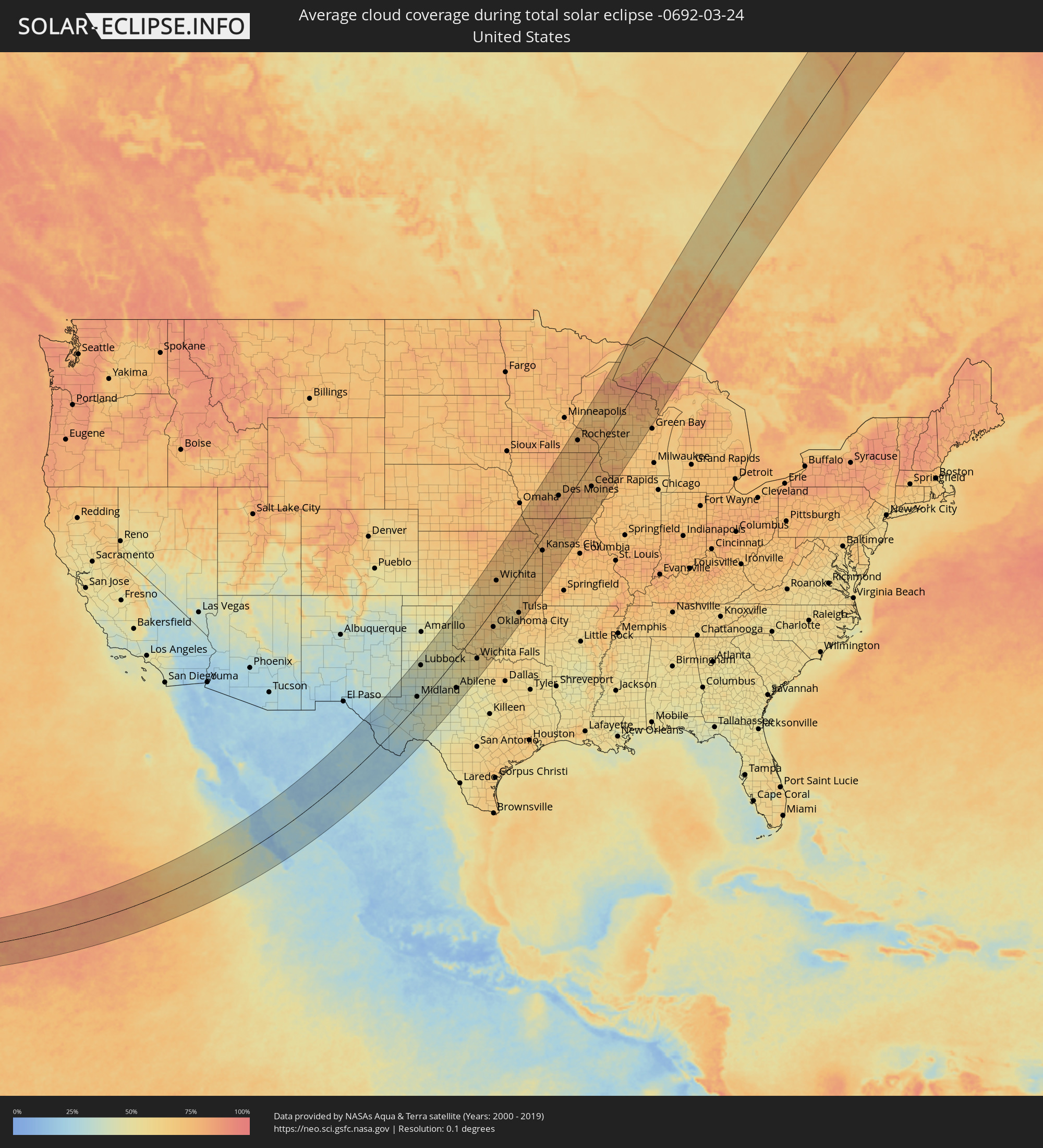 United States
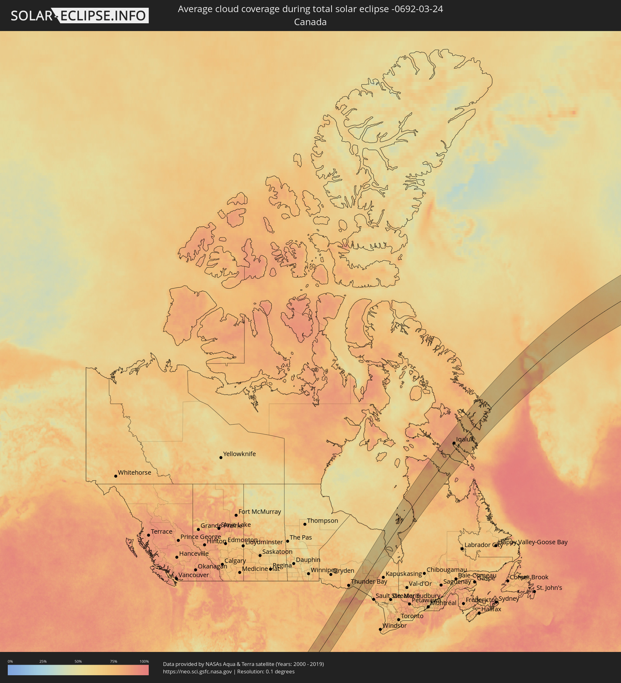 Canada
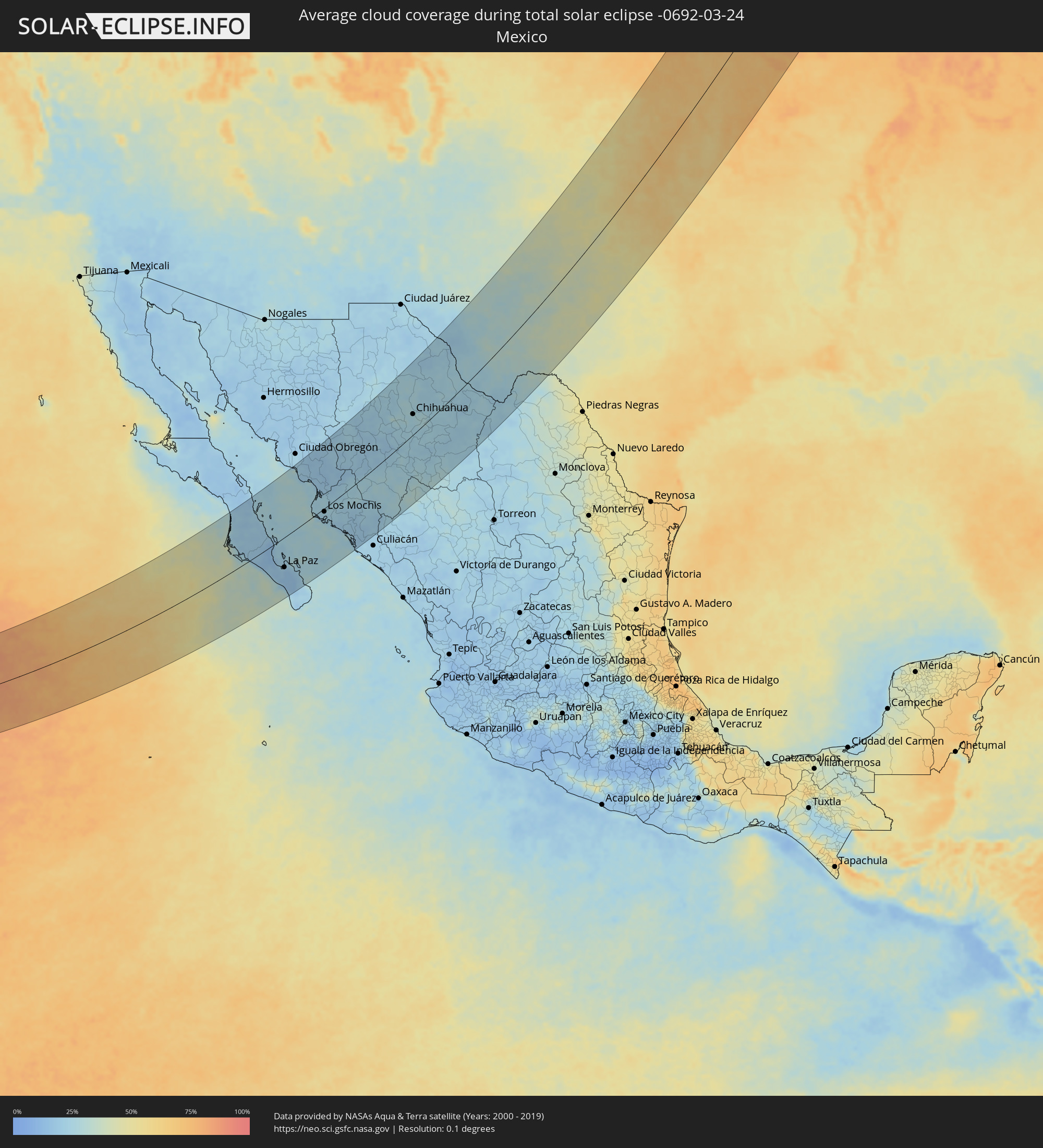 Mexico
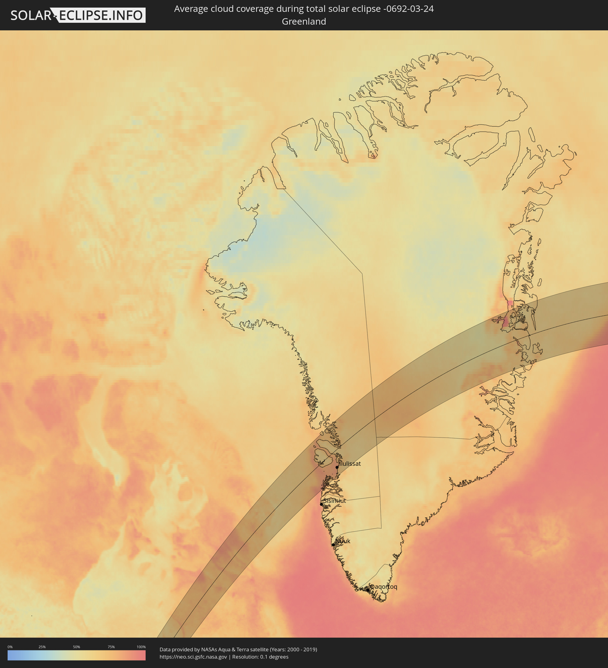 Greenland
Cities inside the path of the eclipse
The following table shows all locations with a population of more than 5,000 inside the eclipse path. Cities which have more than 100,000 inhabitants are marked bold. A click at the locations opens a detailed map.
| City | Type | Eclipse duration | Local time of max. eclipse | Distance to central line | Ø Cloud coverage |
|
Ciudad Insurgentes, Baja California Sur
|
total | - | 08:50:36 UTC-07:05 | 104 km | 20% |
|
Ciudad Constitución, Baja California Sur
|
total | - | 08:50:17 UTC-07:05 | 77 km | 21% |
|
Loreto, Baja California Sur
|
total | - | 08:52:23 UTC-07:05 | 149 km | 24% |
|
La Paz, Baja California Sur
|
total | - | 08:49:59 UTC-07:05 | 82 km | 15% |
|
Villa Juarez, Sonora
|
total | - | 08:37:46 UTC-07:23 | 160 km | 20% |
|
Bacobampo, Sonora
|
total | - | 08:37:41 UTC-07:23 | 136 km | 19% |
|
Huatabampo, Sonora
|
total | - | 08:37:24 UTC-07:23 | 122 km | 21% |
|
Etchojoa, Sonora
|
total | - | 08:37:35 UTC-07:23 | 128 km | 19% |
|
La Unión, Sonora
|
total | - | 08:37:26 UTC-07:23 | 119 km | 21% |
|
Navojoa, Sonora
|
total | - | 08:38:04 UTC-07:23 | 131 km | 18% |
|
Higuera de Zaragoza, Sinaloa
|
total | - | 08:54:22 UTC-07:05 | 25 km | 23% |
|
Ahome, Sinaloa
|
total | - | 08:54:24 UTC-07:05 | 13 km | 24% |
|
Topolobampo, Sinaloa
|
total | - | 08:53:56 UTC-07:05 | 22 km | 27% |
|
San Miguel Zapotitlan, Sinaloa
|
total | - | 08:54:35 UTC-07:05 | 8 km | 24% |
|
Los Mochis, Sinaloa
|
total | - | 08:54:22 UTC-07:05 | 9 km | 23% |
|
Alamos, Sonora
|
total | - | 08:38:31 UTC-07:23 | 96 km | 18% |
|
Juan Jose Rios, Sinaloa
|
total | - | 08:54:28 UTC-07:05 | 22 km | 23% |
|
San Blas, Sinaloa
|
total | - | 08:55:08 UTC-07:05 | 2 km | 23% |
|
Adolfo Ruíz Cortínes, Sinaloa
|
total | - | 08:54:32 UTC-07:05 | 27 km | 23% |
|
Leyva Solano, Sinaloa
|
total | - | 08:54:29 UTC-07:05 | 42 km | 22% |
|
El Fuerte de Montes Claros, Sinaloa
|
total | - | 08:55:54 UTC-07:05 | 23 km | 21% |
|
Guasave, Sinaloa
|
total | - | 08:54:29 UTC-07:05 | 61 km | 19% |
|
Choix, Sinaloa
|
total | - | 08:56:46 UTC-07:05 | 31 km | 22% |
|
Guamúchil, Sinaloa
|
total | - | 08:54:42 UTC-07:05 | 94 km | 18% |
|
La Reforma, Sinaloa
|
total | - | 08:54:01 UTC-07:05 | 129 km | 22% |
|
Mocorito, Sinaloa
|
total | - | 08:54:54 UTC-07:05 | 102 km | 18% |
|
Creel, Chihuahua
|
total | - | 08:59:28 UTC-07:05 | 76 km | 19% |
|
Adolfo López Mateos, Chihuahua
|
total | - | 09:01:11 UTC-07:05 | 115 km | 22% |
|
Cuauhtémoc, Chihuahua
|
total | - | 09:01:33 UTC-07:05 | 81 km | 24% |
|
Anáhuac, Chihuahua
|
total | - | 09:01:49 UTC-07:05 | 80 km | 26% |
|
Valentín Gómez Farías, Chihuahua
|
total | - | 09:01:30 UTC-07:05 | 47 km | 24% |
|
Chihuahua, Chihuahua
|
total | - | 09:02:51 UTC-07:05 | 49 km | 25% |
|
Santa Bárbara, Chihuahua
|
total | - | 08:59:41 UTC-07:05 | 121 km | 27% |
|
Hidalgo del Parral, Chihuahua
|
total | - | 09:00:06 UTC-07:05 | 120 km | 25% |
|
Ampliación Colonia Lázaro Cárdenas, Chihuahua
|
total | - | 09:02:54 UTC-07:05 | 3 km | 24% |
|
Rosales, Chihuahua
|
total | - | 09:02:36 UTC-07:05 | 23 km | 25% |
|
Naica, Chihuahua
|
total | - | 09:02:03 UTC-07:05 | 55 km | 24% |
|
Pedro Meoqui, Chihuahua
|
total | - | 09:02:52 UTC-07:05 | 20 km | 23% |
|
Ciudad Delicias, Chihuahua
|
total | - | 09:02:42 UTC-07:05 | 29 km | 25% |
|
Jiménez, Chihuahua
|
total | - | 09:03:03 UTC-07:05 | 22 km | 24% |
|
Saucillo, Chihuahua
|
total | - | 09:02:36 UTC-07:05 | 54 km | 23% |
|
Ciudad Camargo, Chihuahua
|
total | - | 09:02:04 UTC-07:05 | 91 km | 22% |
|
Ojinaga, Chihuahua
|
total | - | 09:06:23 UTC-07:05 | 19 km | 25% |
|
Manuel Ojinaga, Chihuahua
|
total | - | 09:06:31 UTC-07:05 | 10 km | 24% |
|
Hobbs, New Mexico
|
total | - | 09:19:39 UTC-07:00 | 157 km | 38% |
|
Odessa, Texas
|
total | - | 10:18:57 UTC-06:00 | 40 km | 33% |
|
Midland, Texas
|
total | - | 10:19:35 UTC-06:00 | 31 km | 38% |
|
Lubbock, Texas
|
total | - | 10:22:50 UTC-06:00 | 128 km | 42% |
|
Big Spring, Texas
|
total | - | 10:20:48 UTC-06:00 | 6 km | 40% |
|
San Angelo, Texas
|
total | - | 10:20:36 UTC-06:00 | 126 km | 43% |
|
Abilene, Texas
|
total | - | 10:23:20 UTC-06:00 | 105 km | 47% |
|
Wichita Falls, Texas
|
total | - | 10:27:39 UTC-06:00 | 92 km | 57% |
|
Lawton, Oklahoma
|
total | - | 10:29:04 UTC-06:00 | 52 km | 62% |
|
Hutchinson, Kansas
|
total | - | 10:35:54 UTC-06:00 | 140 km | 68% |
|
Enid, Oklahoma
|
total | - | 10:32:59 UTC-06:00 | 30 km | 68% |
|
Oklahoma City, Oklahoma
|
total | - | 10:31:45 UTC-06:00 | 58 km | 65% |
|
Edmond, Oklahoma
|
total | - | 10:32:08 UTC-06:00 | 48 km | 65% |
|
Norman, Oklahoma
|
total | - | 10:31:24 UTC-06:00 | 80 km | 61% |
|
Wichita, Kansas
|
total | - | 10:36:00 UTC-06:00 | 74 km | 70% |
|
Ponca City, Oklahoma
|
total | - | 10:34:33 UTC-06:00 | 8 km | 69% |
|
Stillwater, Oklahoma
|
total | - | 10:33:31 UTC-06:00 | 48 km | 62% |
|
Shawnee, Oklahoma
|
total | - | 10:32:15 UTC-06:00 | 110 km | 61% |
|
Manhattan, Kansas
|
total | - | 10:39:35 UTC-06:00 | 111 km | 71% |
|
Emporia, Kansas
|
total | - | 10:38:43 UTC-06:00 | 35 km | 69% |
|
Tulsa, Oklahoma
|
total | - | 10:34:58 UTC-06:00 | 123 km | 64% |
|
Bartlesville, Oklahoma
|
total | - | 10:36:02 UTC-06:00 | 85 km | 65% |
|
Owasso, Oklahoma
|
total | - | 10:35:21 UTC-06:00 | 126 km | 68% |
|
Broken Arrow, Oklahoma
|
total | - | 10:35:02 UTC-06:00 | 144 km | 69% |
|
Topeka, Kansas
|
total | - | 10:40:29 UTC-06:00 | 39 km | 73% |
|
Lawrence, Kansas
|
total | - | 10:40:55 UTC-06:00 | 2 km | 74% |
|
Leavenworth, Kansas
|
total | - | 10:41:54 UTC-06:00 | 1 km | 74% |
|
Saint Joseph, Missouri
|
total | - | 10:42:47 UTC-06:00 | 24 km | 75% |
|
Olathe, Kansas
|
total | - | 10:41:17 UTC-06:00 | 33 km | 76% |
|
Overland Park, Kansas
|
total | - | 10:41:39 UTC-06:00 | 38 km | 74% |
|
Kansas City, Missouri
|
total | - | 10:41:58 UTC-06:00 | 37 km | 72% |
|
Liberty, Missouri
|
total | - | 10:42:26 UTC-06:00 | 39 km | 75% |
|
Lee's Summit, Missouri
|
total | - | 10:41:54 UTC-06:00 | 63 km | 74% |
|
East Independence, Missouri
|
total | - | 10:42:15 UTC-06:00 | 53 km | 74% |
|
Fort Dodge, Iowa
|
total | - | 10:48:10 UTC-06:00 | 139 km | 74% |
|
Ames, Iowa
|
total | - | 10:48:06 UTC-06:00 | 74 km | 74% |
|
Des Moines, Iowa
|
total | - | 10:47:24 UTC-06:00 | 47 km | 77% |
|
Mason City, Iowa
|
total | - | 10:50:25 UTC-06:00 | 110 km | 75% |
|
Marshalltown, Iowa
|
total | - | 10:49:01 UTC-06:00 | 25 km | 76% |
|
Rochester, Minnesota
|
total | - | 10:52:41 UTC-06:00 | 110 km | 76% |
|
Ottumwa, Iowa
|
total | - | 10:47:58 UTC-06:00 | 72 km | 72% |
|
Waterloo, Iowa
|
total | - | 10:50:26 UTC-06:00 | 12 km | 73% |
|
Cedar Rapids, Iowa
|
total | - | 10:50:33 UTC-06:00 | 66 km | 74% |
|
Winona, Minnesota
|
total | - | 10:53:45 UTC-06:00 | 55 km | 75% |
|
Iowa City, Iowa
|
total | - | 10:50:08 UTC-06:00 | 95 km | 77% |
|
Eau Claire, Wisconsin
|
total | - | 10:55:05 UTC-06:00 | 90 km | 75% |
|
La Crosse, Wisconsin
|
total | - | 10:53:52 UTC-06:00 | 14 km | 72% |
|
Dubuque, Iowa
|
total | - | 10:52:34 UTC-06:00 | 104 km | 76% |
|
Wausau, Wisconsin
|
total | - | 10:57:36 UTC-06:00 | 27 km | 77% |
|
Stevens Point, Wisconsin
|
total | - | 10:57:01 UTC-06:00 | 56 km | 68% |
|
Thunder Bay, Ontario
|
total | - | 12:02:51 UTC-05:00 | 147 km | 79% |
|
Iqaluit, Nunavut
|
total | - | 12:35:00 UTC-05:00 | 42 km | 78% |
|
Ilulissat, Qaasuitsup
|
total | - | 14:18:06 UTC-03:26 | 91 km | 77% |