Annular solar eclipse of 04/13/-0786
| Day of week: | Friday |
| Maximum duration of eclipse: | 01m43s |
| Maximum width of eclipse path: | 163 km |
| Saros cycle: | 55 |
| Coverage: | 97.7% |
| Magnitude: | 0.9772 |
| Gamma: | 0.8723 |
Wo kann man die Sonnenfinsternis vom 04/13/-0786 sehen?
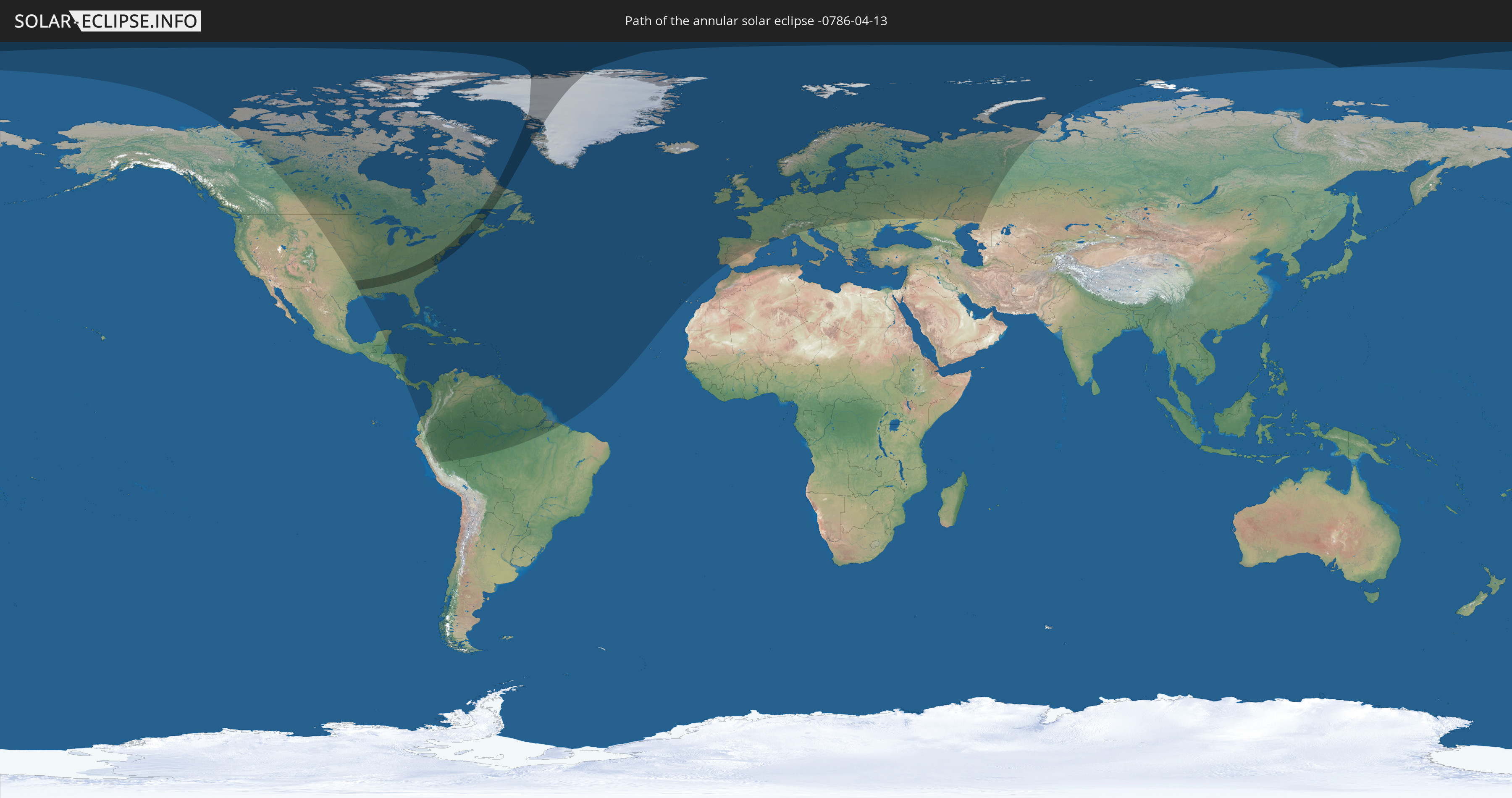
Die Sonnenfinsternis am 04/13/-0786 kann man in 84 Ländern als partielle Sonnenfinsternis beobachten.
Der Finsternispfad verläuft durch 3 Länder. Nur in diesen Ländern ist sie als annular Sonnenfinsternis zu sehen.
In den folgenden Ländern ist die Sonnenfinsternis annular zu sehen
 United States
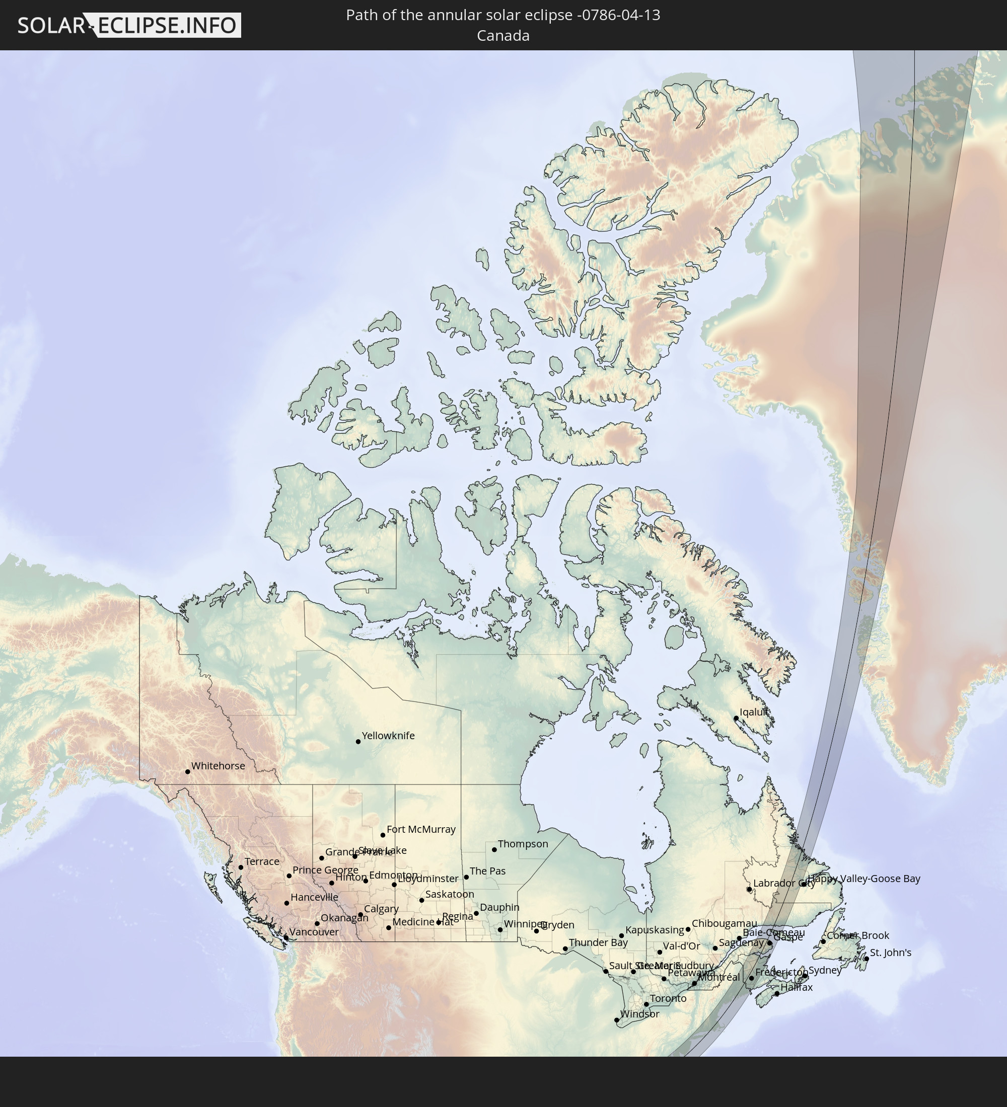 Canada
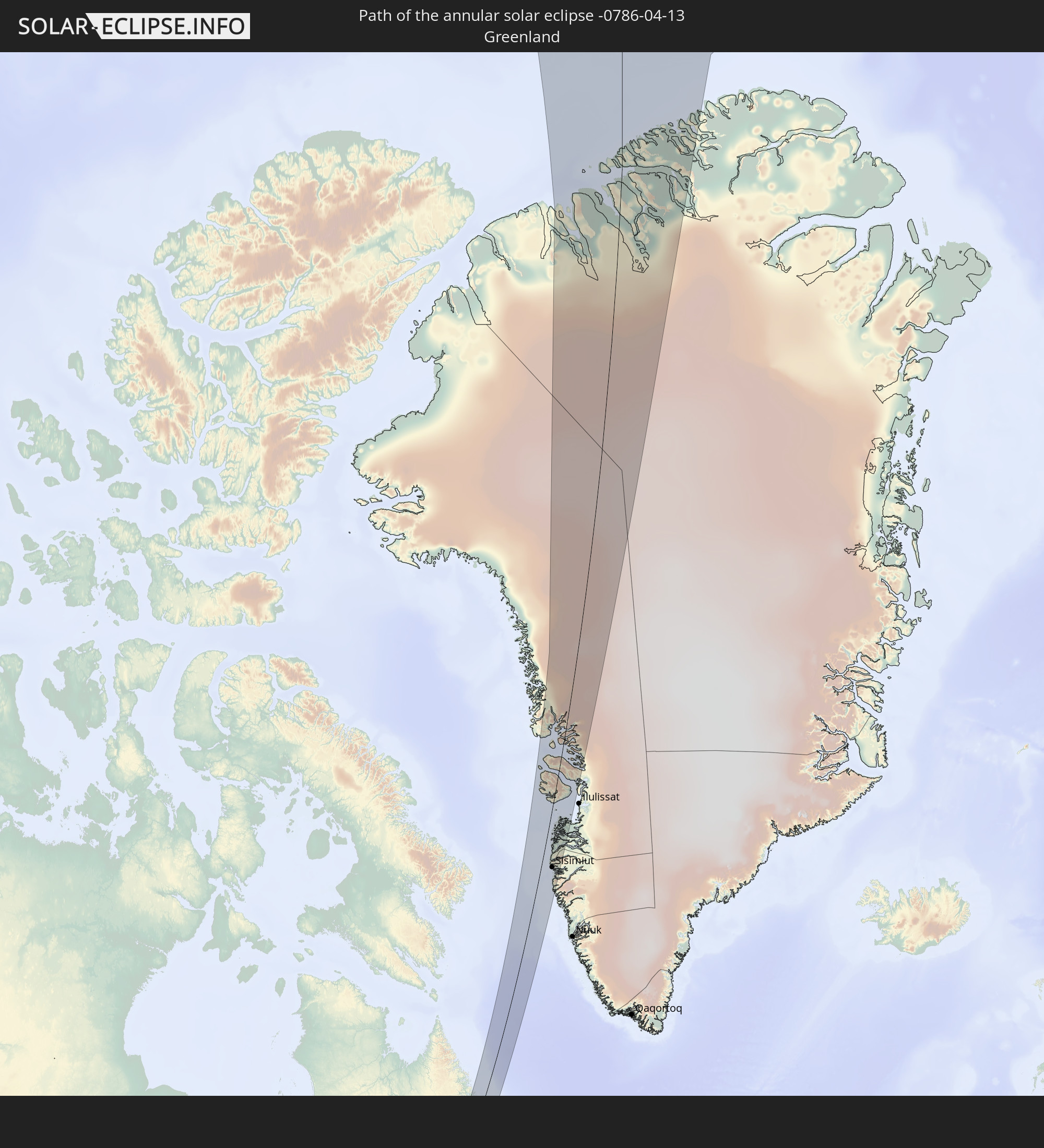 Greenland
In den folgenden Ländern ist die Sonnenfinsternis partiell zu sehen
 Russia
 United States
 United States Minor Outlying Islands
 Canada
 Mexico
 Greenland
 Ecuador
 Honduras
 Nicaragua
 Costa Rica
 Cuba
Cuba
 Panama
 Colombia
 Cayman Islands
 Peru
Peru
 The Bahamas
 Jamaica
 Haiti
Haiti
 Brazil
 Venezuela
 Turks and Caicos Islands
 Dominican Republic
 Aruba
Aruba
 Puerto Rico
 United States Virgin Islands
 Bermuda
 British Virgin Islands
 Anguilla
 Collectivity of Saint Martin
 Saint Barthélemy
 Saint Kitts and Nevis
 Antigua and Barbuda
 Montserrat
 Trinidad and Tobago
 Guadeloupe
 Grenada
 Dominica
 Saint Vincent and the Grenadines
 Guyana
 Martinique
 Saint Lucia
 Barbados
 Suriname
 Saint Pierre and Miquelon
 French Guiana
 Portugal
 Iceland
 Spain
Spain
 Republic of Ireland
 Svalbard and Jan Mayen
 United Kingdom
 Faroe Islands
 France
 Isle of Man
 Guernsey
 Jersey
 Andorra
 Belgium
 Netherlands
 Norway
 Luxembourg
 Germany
 Switzerland
 Italy
Italy
 Denmark
 Liechtenstein
 Austria
 Sweden
 Czechia
 Slovenia
 Croatia
 Poland
 Hungary
 Slovakia
 Åland Islands
 Romania
 Finland
 Lithuania
 Latvia
 Estonia
 Ukraine
 Belarus
 Moldova
 Kazakhstan
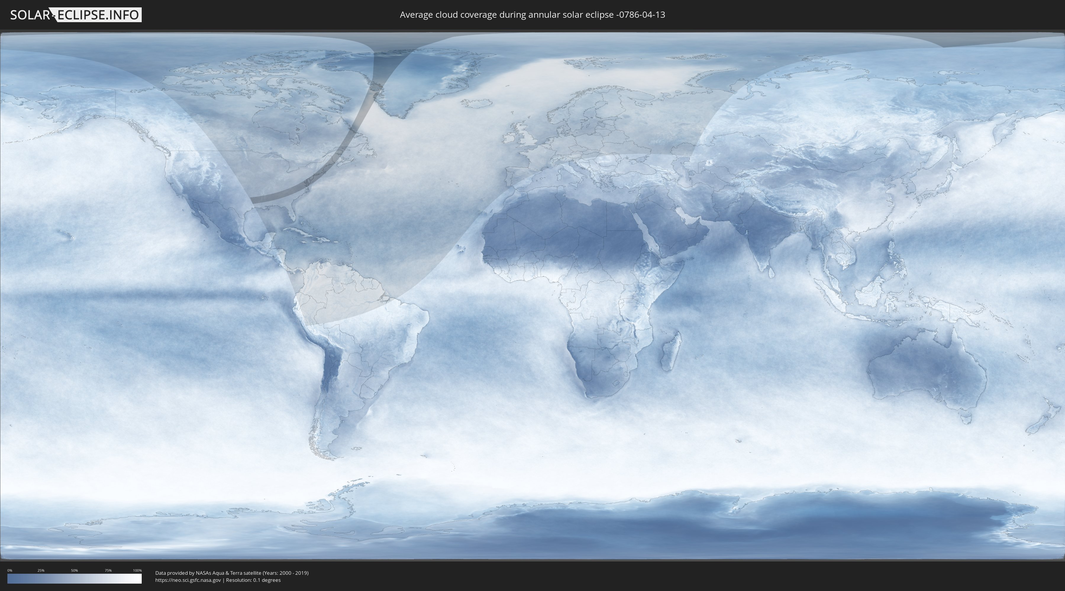
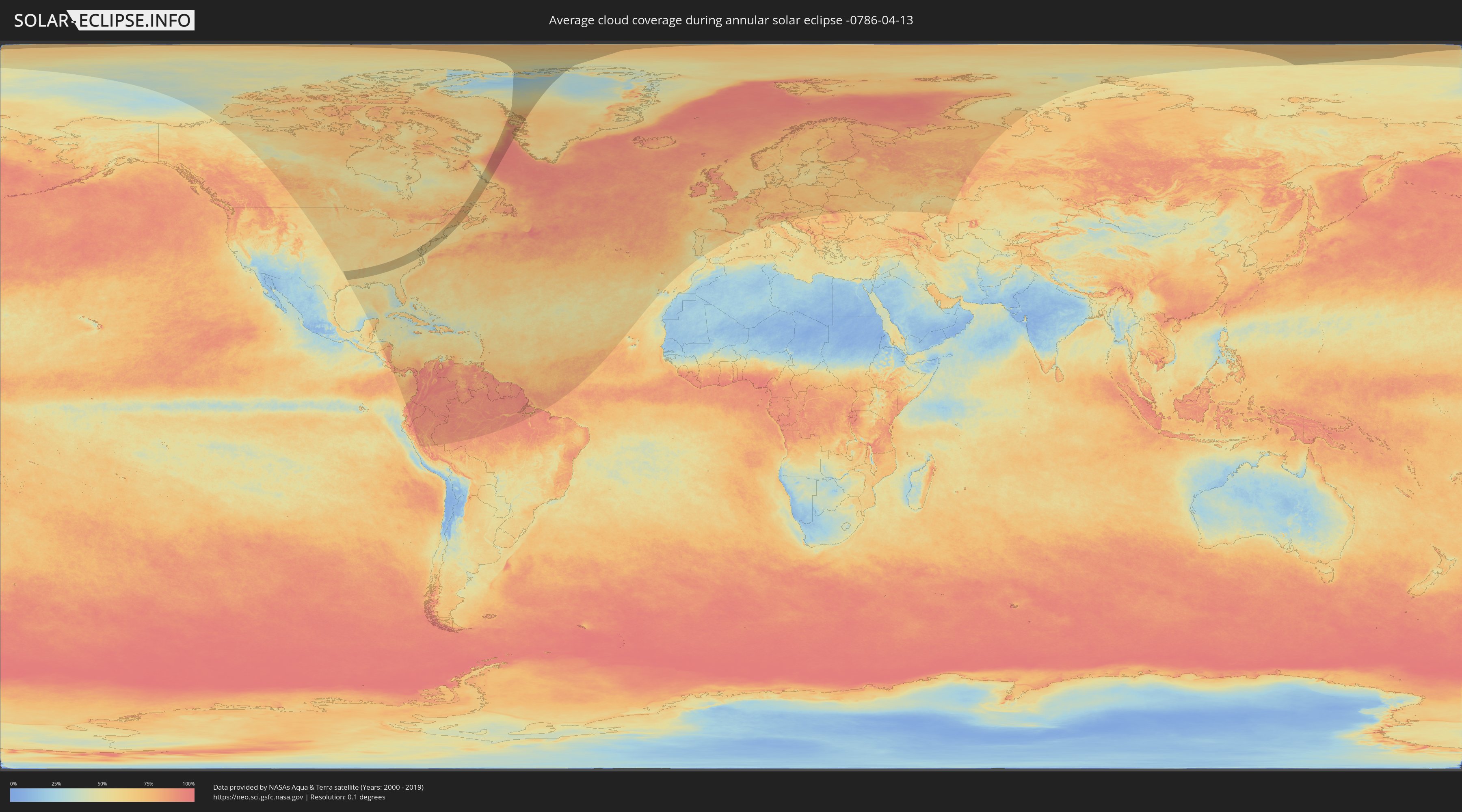
How will be the weather during the annular solar eclipse on 04/13/-0786?
Where is the best place to see the annular solar eclipse of 04/13/-0786?
The following maps show the average cloud coverage for the day of the annular solar eclipse.
With the help of these maps, it is possible to find the place along the eclipse path, which has the best
chance of a cloudless sky.
Nevertheless, you should consider local circumstances and inform about the weather of your chosen
observation site.
The data is provided by NASAs satellites
AQUA and TERRA.
The cloud maps are averaged over a period of 19 years (2000 - 2019).
Detailed country maps
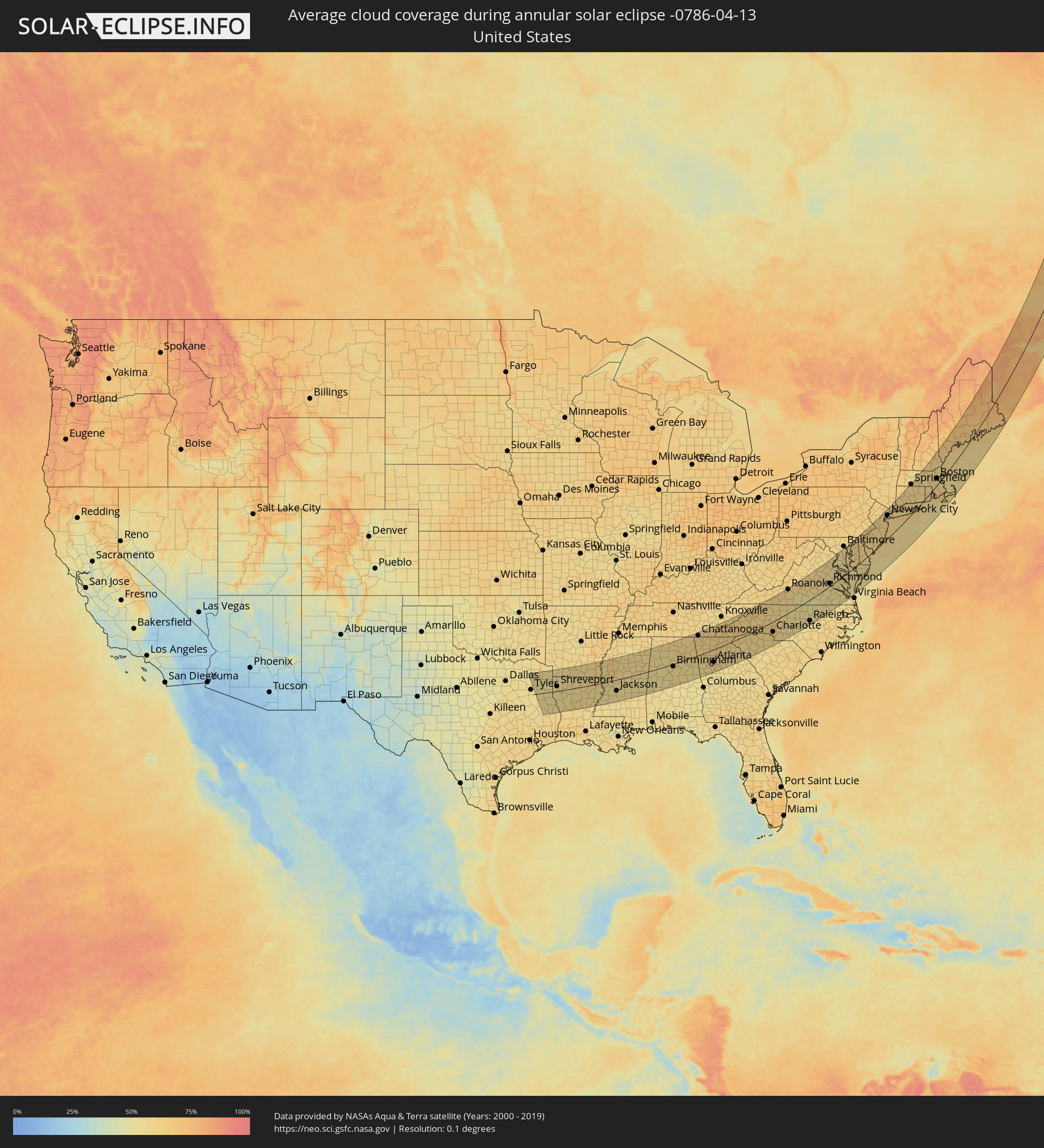 United States
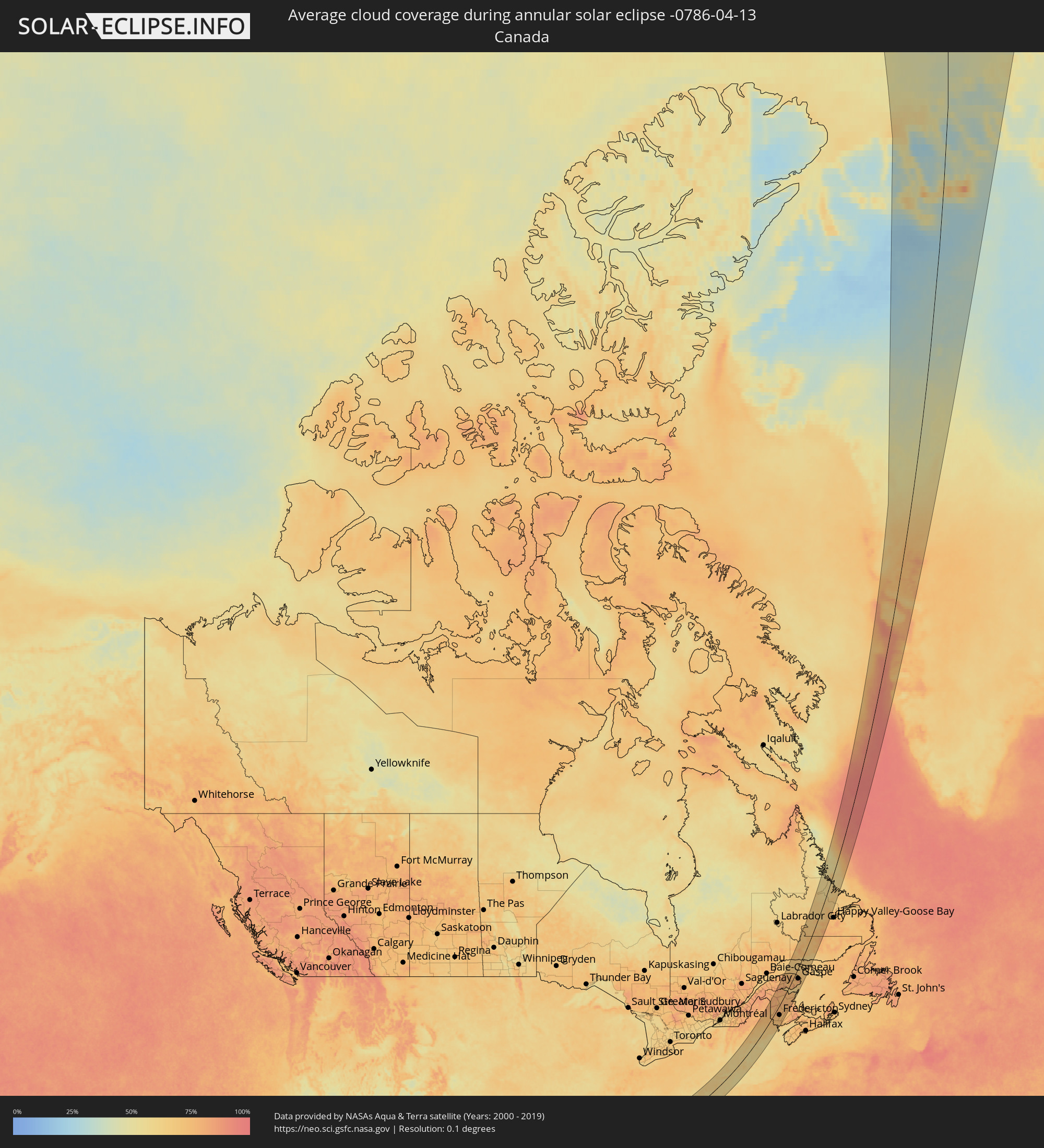 Canada
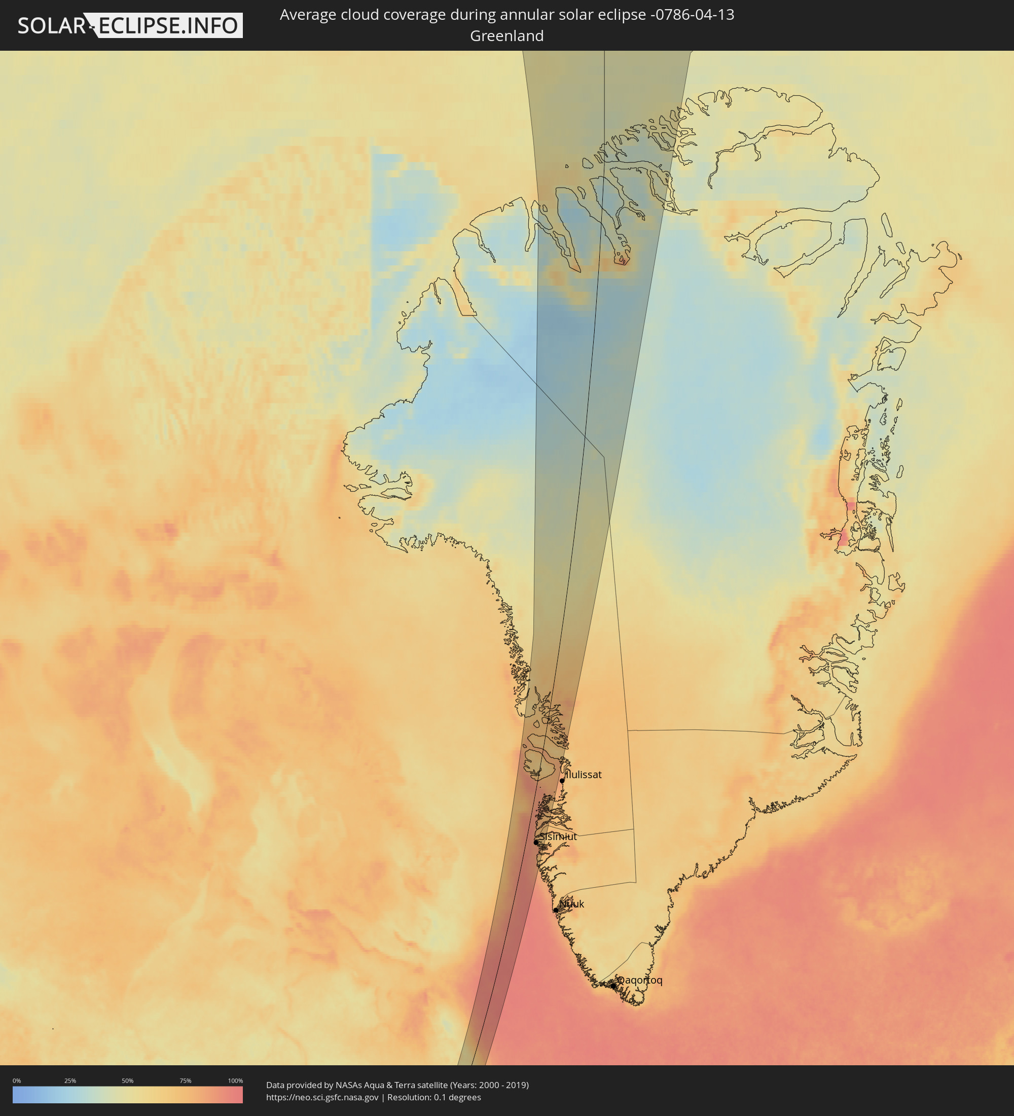 Greenland
Cities inside the path of the eclipse
The following table shows all locations with a population of more than 5,000 inside the eclipse path. Cities which have more than 100,000 inhabitants are marked bold. A click at the locations opens a detailed map.
| City | Type | Eclipse duration | Local time of max. eclipse | Distance to central line | Ø Cloud coverage |
|
Longview, Texas
|
annular | - | 06:07:49 UTC-06:00 | 37 km | 54% |
|
Shreveport, Louisiana
|
annular | - | 06:07:42 UTC-06:00 | 27 km | 56% |
|
Jackson, Mississippi
|
annular | - | 06:06:58 UTC-06:00 | 60 km | 57% |
|
Tuscaloosa, Alabama
|
annular | - | 06:08:31 UTC-06:00 | 24 km | 54% |
|
Birmingham, Alabama
|
annular | - | 06:09:06 UTC-06:00 | 12 km | 56% |
|
Huntsville, Alabama
|
annular | - | 06:11:19 UTC-06:00 | 109 km | 60% |
|
Chattanooga, Tennessee
|
annular | - | 07:12:00 UTC-05:00 | 102 km | 59% |
|
Atlanta, Georgia
|
annular | - | 07:09:41 UTC-05:00 | 63 km | 59% |
|
Sandy Springs, Georgia
|
annular | - | 07:10:00 UTC-05:00 | 45 km | 60% |
|
Johns Creek, Georgia
|
annular | - | 07:10:13 UTC-05:00 | 41 km | 60% |
|
Athens, Georgia
|
annular | - | 07:10:11 UTC-05:00 | 77 km | 58% |
|
Asheville, North Carolina
|
annular | - | 07:13:24 UTC-05:00 | 59 km | 61% |
|
Greenville, South Carolina
|
annular | - | 07:12:00 UTC-05:00 | 23 km | 60% |
|
Gastonia, North Carolina
|
annular | - | 07:13:00 UTC-05:00 | 31 km | 61% |
|
Rock Hill, South Carolina
|
annular | - | 07:12:23 UTC-05:00 | 71 km | 61% |
|
Charlotte, North Carolina
|
annular | - | 07:13:00 UTC-05:00 | 49 km | 61% |
|
Concord, North Carolina
|
annular | - | 07:13:24 UTC-05:00 | 42 km | 61% |
|
Winston-Salem, North Carolina
|
annular | - | 07:14:49 UTC-05:00 | 10 km | 58% |
|
High Point, North Carolina
|
annular | - | 07:14:35 UTC-05:00 | 14 km | 58% |
|
Roanoke, Virginia
|
annular | - | 07:17:10 UTC-05:00 | 108 km | 60% |
|
Greensboro, North Carolina
|
annular | - | 07:14:52 UTC-05:00 | 13 km | 58% |
|
Lynchburg, Virginia
|
annular | - | 07:17:40 UTC-05:00 | 84 km | 59% |
|
Durham, North Carolina
|
annular | - | 07:14:56 UTC-05:00 | 62 km | 57% |
|
Raleigh, North Carolina
|
annular | - | 07:14:34 UTC-05:00 | 95 km | 56% |
|
Richmond, Virginia
|
annular | - | 07:18:26 UTC-05:00 | 12 km | 59% |
|
Dale City, Virginia
|
annular | - | 07:20:39 UTC-05:00 | 101 km | 56% |
|
Washington, D.C., Washington, D.C.
|
annular | - | 07:21:16 UTC-05:00 | 109 km | 59% |
|
Waldorf, Maryland
|
annular | - | 07:20:45 UTC-05:00 | 80 km | 57% |
|
Glen Burnie, Maryland
|
annular | - | 07:21:57 UTC-05:00 | 109 km | 57% |
|
Suffolk, Virginia
|
annular | - | 07:17:04 UTC-05:00 | 108 km | 56% |
|
Newport News, Virginia
|
annular | - | 07:17:49 UTC-05:00 | 82 km | 54% |
|
Wilmington, Delaware
|
annular | - | 07:23:32 UTC-05:00 | 97 km | 61% |
|
Philadelphia, Pennsylvania
|
annular | - | 07:24:06 UTC-05:00 | 92 km | 64% |
|
Vineland, New Jersey
|
annular | - | 07:23:12 UTC-05:00 | 46 km | 61% |
|
Trenton, New Jersey
|
annular | - | 07:24:49 UTC-05:00 | 89 km | 61% |
|
Edison, New Jersey
|
annular | - | 07:25:34 UTC-05:00 | 93 km | 61% |
|
Irvington, New Jersey
|
annular | - | 07:26:05 UTC-05:00 | 99 km | 62% |
|
Toms River, New Jersey
|
annular | - | 07:24:30 UTC-05:00 | 36 km | 64% |
|
Clifton, New Jersey
|
annular | - | 07:26:23 UTC-05:00 | 105 km | 63% |
|
Staten Island, New York
|
annular | - | 07:25:46 UTC-05:00 | 80 km | 60% |
|
New York City, New York
|
annular | - | 07:26:09 UTC-05:00 | 84 km | 62% |
|
The Bronx, New York
|
annular | - | 07:26:29 UTC-05:00 | 86 km | 62% |
|
Greenburgh, New York
|
annular | - | 07:26:53 UTC-05:00 | 99 km | 61% |
|
Jamaica, New York
|
annular | - | 07:26:11 UTC-05:00 | 70 km | 62% |
|
Stamford, Connecticut
|
annular | - | 07:27:03 UTC-05:00 | 82 km | 61% |
|
Danbury, Connecticut
|
annular | - | 07:27:48 UTC-05:00 | 102 km | 62% |
|
Brentwood, New York
|
annular | - | 07:26:37 UTC-05:00 | 43 km | 59% |
|
Bridgeport, Connecticut
|
annular | - | 07:27:26 UTC-05:00 | 70 km | 60% |
|
Waterbury, Connecticut
|
annular | - | 07:28:19 UTC-05:00 | 90 km | 60% |
|
Bristol, Connecticut
|
annular | - | 07:28:36 UTC-05:00 | 92 km | 62% |
|
New Haven, Connecticut
|
annular | - | 07:27:51 UTC-05:00 | 63 km | 61% |
|
Meriden, Connecticut
|
annular | - | 07:28:23 UTC-05:00 | 73 km | 62% |
|
Hartford, Connecticut
|
annular | - | 07:28:55 UTC-05:00 | 82 km | 61% |
|
Springfield, Massachusetts
|
annular | - | 07:29:40 UTC-05:00 | 100 km | 59% |
|
Worcester, Massachusetts
|
annular | - | 07:30:23 UTC-05:00 | 62 km | 59% |
|
Nashua, New Hampshire
|
annular | - | 07:31:36 UTC-05:00 | 75 km | 61% |
|
Manchester, New Hampshire
|
annular | - | 07:32:06 UTC-05:00 | 90 km | 60% |
|
Framingham, Massachusetts
|
annular | - | 07:30:37 UTC-05:00 | 39 km | 59% |
|
Providence, Rhode Island
|
annular | - | 07:29:40 UTC-05:00 | 6 km | 61% |
|
Lowell, Massachusetts
|
annular | - | 07:31:24 UTC-05:00 | 57 km | 58% |
|
Fall River, Massachusetts
|
annular | - | 07:29:32 UTC-05:00 | 19 km | 59% |
|
Haverhill, Massachusetts
|
annular | - | 07:31:50 UTC-05:00 | 51 km | 60% |
|
Boston, Massachusetts
|
annular | - | 07:30:57 UTC-05:00 | 21 km | 61% |
|
Brockton, Massachusetts
|
annular | - | 07:30:24 UTC-05:00 | 1 km | 60% |
|
Lynn, Massachusetts
|
annular | - | 07:31:15 UTC-05:00 | 22 km | 61% |
|
New Bedford, Massachusetts
|
annular | - | 07:29:30 UTC-05:00 | 38 km | 65% |
|
Portland, Maine
|
annular | - | 07:34:07 UTC-05:00 | 57 km | 62% |
|
Campbellton, New Brunswick
|
annular | - | 08:30:59 UTC-04:14 | 67 km | 81% |
|
Fredericton, New Brunswick
|
annular | - | 08:26:38 UTC-04:14 | 44 km | 74% |
|
Oromocto, New Brunswick
|
annular | - | 08:26:31 UTC-04:14 | 62 km | 72% |
|
Bathurst, New Brunswick
|
annular | - | 08:30:49 UTC-04:14 | 21 km | 76% |
|
Miramichi, New Brunswick
|
annular | - | 08:29:40 UTC-04:14 | 62 km | 78% |
|
Chandler, Quebec
|
annular | - | 07:47:24 UTC-05:00 | 49 km | 70% |
|
Gaspé, Quebec
|
annular | - | 07:48:33 UTC-05:00 | 38 km | 79% |
|
Sisimiut, Qeqqata
|
annular | - | 10:02:39 UTC-03:26 | 46 km | 85% |