Annular solar eclipse of 07/22/-0996
| Day of week: | Friday |
| Maximum duration of eclipse: | 02m45s |
| Maximum width of eclipse path: | 141 km |
| Saros cycle: | 49 |
| Coverage: | 96.9% |
| Magnitude: | 0.9685 |
| Gamma: | 0.59 |
Wo kann man die Sonnenfinsternis vom 07/22/-0996 sehen?
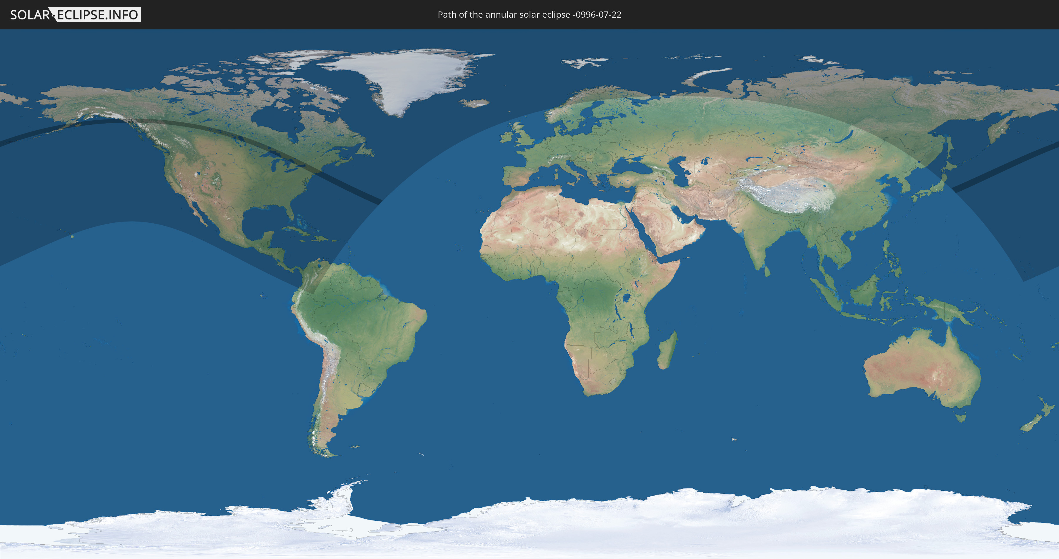
Die Sonnenfinsternis am 07/22/-0996 kann man in 41 Ländern als partielle Sonnenfinsternis beobachten.
Der Finsternispfad verläuft durch 2 Länder. Nur in diesen Ländern ist sie als annular Sonnenfinsternis zu sehen.
In den folgenden Ländern ist die Sonnenfinsternis annular zu sehen
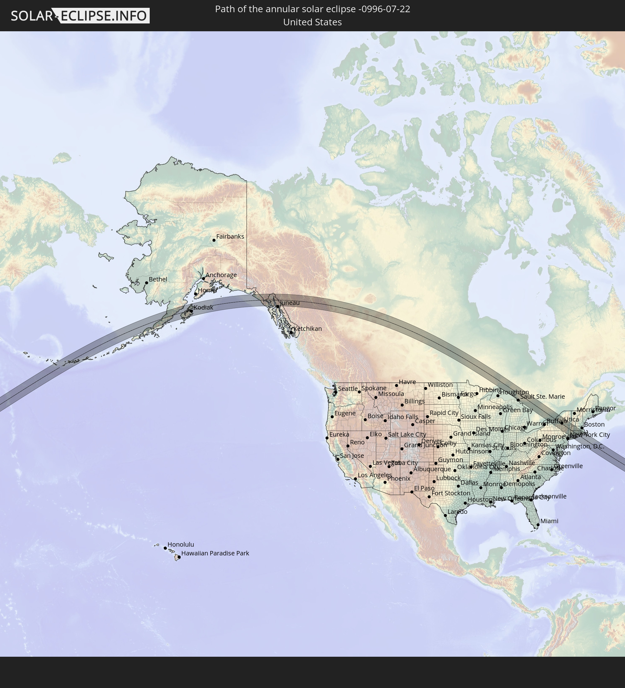 United States
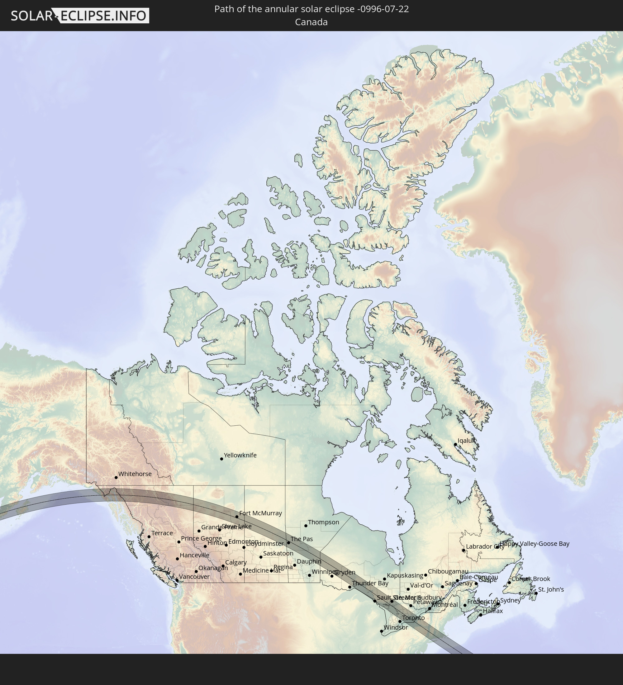 Canada
In den folgenden Ländern ist die Sonnenfinsternis partiell zu sehen
 Russia
 United States
 United States Minor Outlying Islands
 Canada
 Mexico
 Greenland
 Guatemala
 El Salvador
 Honduras
 Belize
 Nicaragua
 Costa Rica
 Cuba
Cuba
 Panama
 Colombia
 Cayman Islands
 The Bahamas
 Jamaica
 Haiti
Haiti
 Venezuela
 Turks and Caicos Islands
 Dominican Republic
 Aruba
Aruba
 Puerto Rico
 United States Virgin Islands
 Bermuda
 British Virgin Islands
 Anguilla
 Collectivity of Saint Martin
 Saint Barthélemy
 Saint Kitts and Nevis
 Saint Pierre and Miquelon
 Iceland
 Svalbard and Jan Mayen
 Faroe Islands
 Norway
 Sweden
 Finland
 China
China
 Japan
Japan
 Marshall Islands
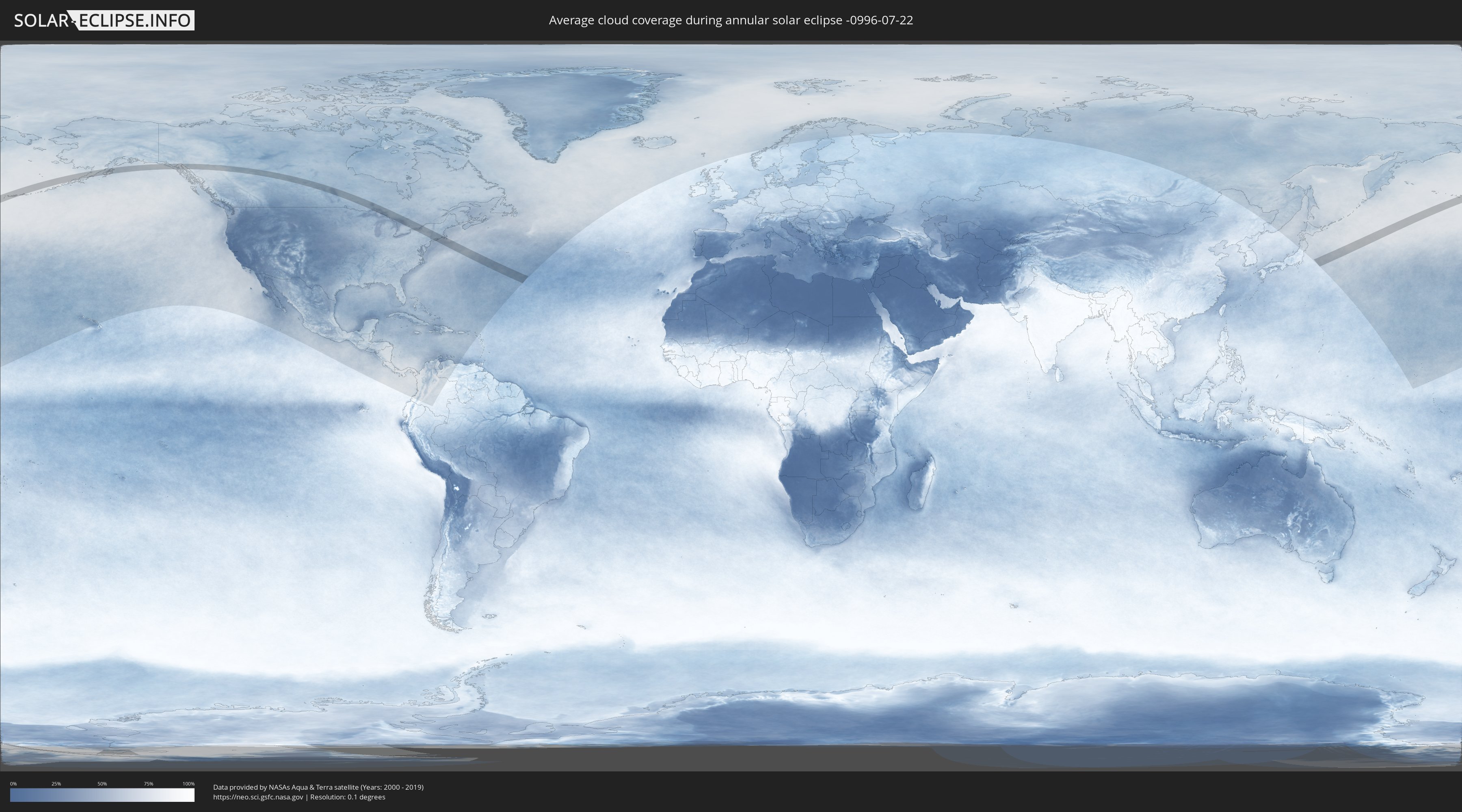
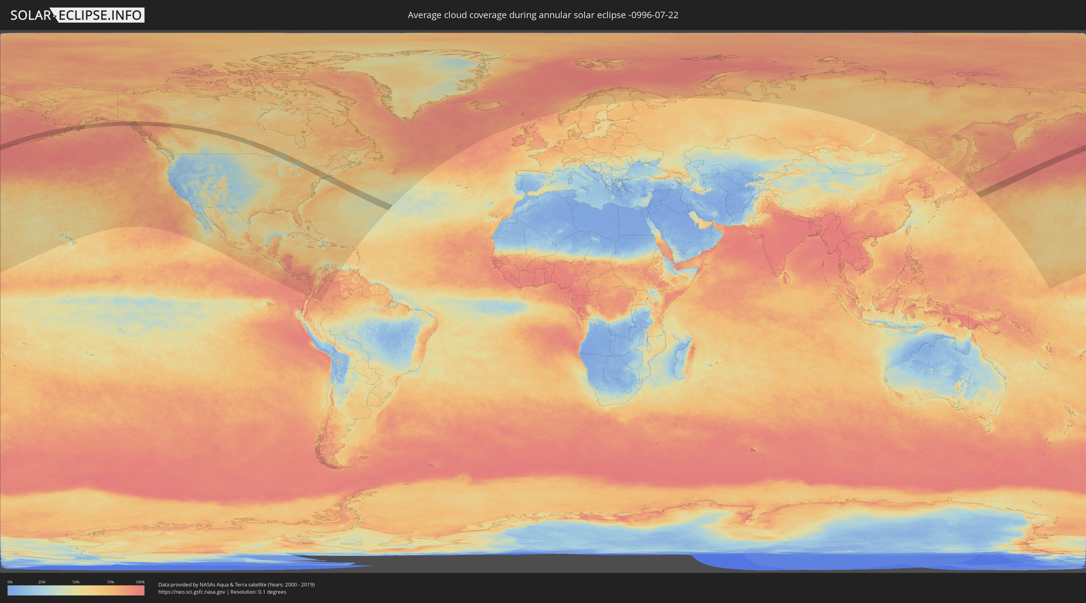
How will be the weather during the annular solar eclipse on 07/22/-0996?
Where is the best place to see the annular solar eclipse of 07/22/-0996?
The following maps show the average cloud coverage for the day of the annular solar eclipse.
With the help of these maps, it is possible to find the place along the eclipse path, which has the best
chance of a cloudless sky.
Nevertheless, you should consider local circumstances and inform about the weather of your chosen
observation site.
The data is provided by NASAs satellites
AQUA and TERRA.
The cloud maps are averaged over a period of 19 years (2000 - 2019).
Detailed country maps
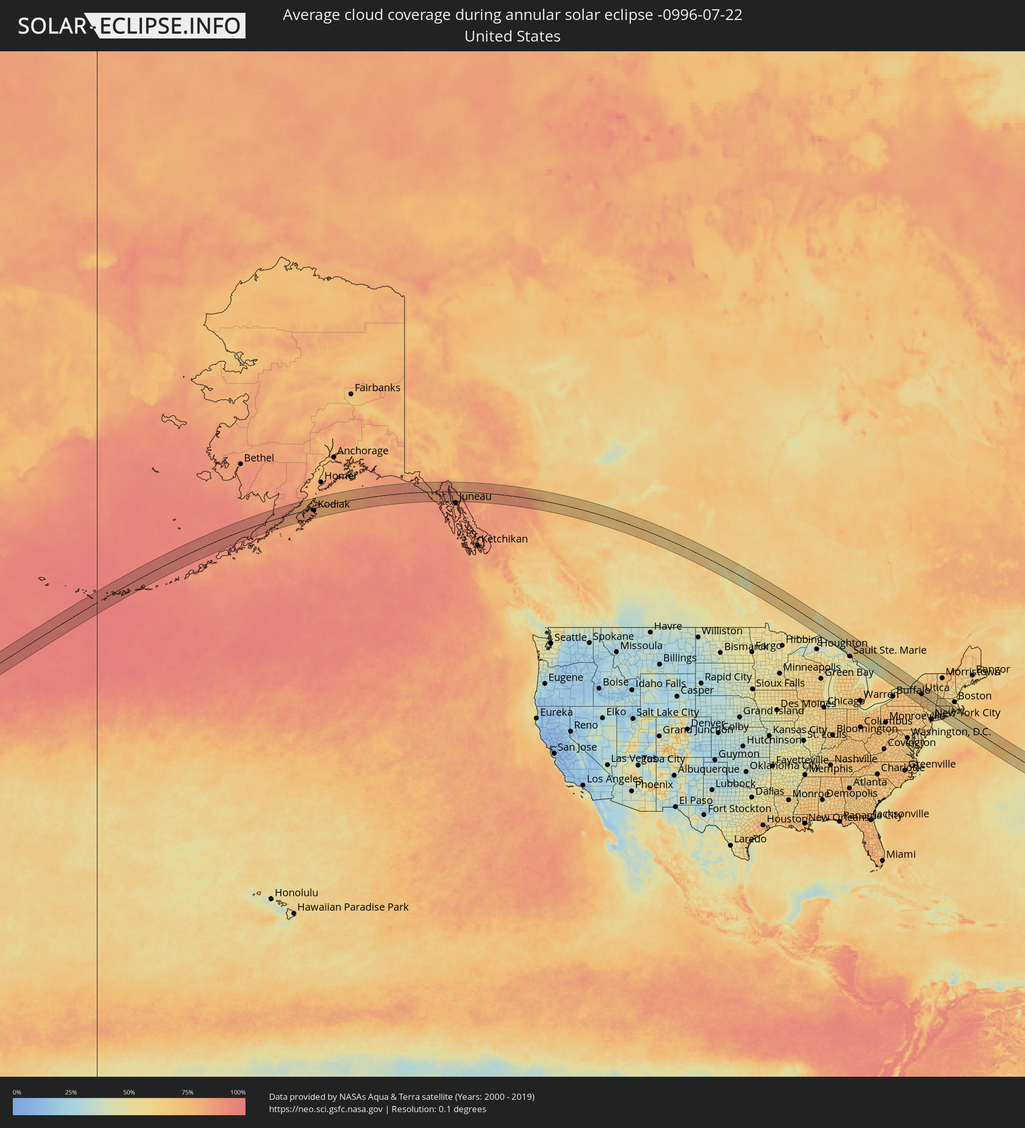 United States
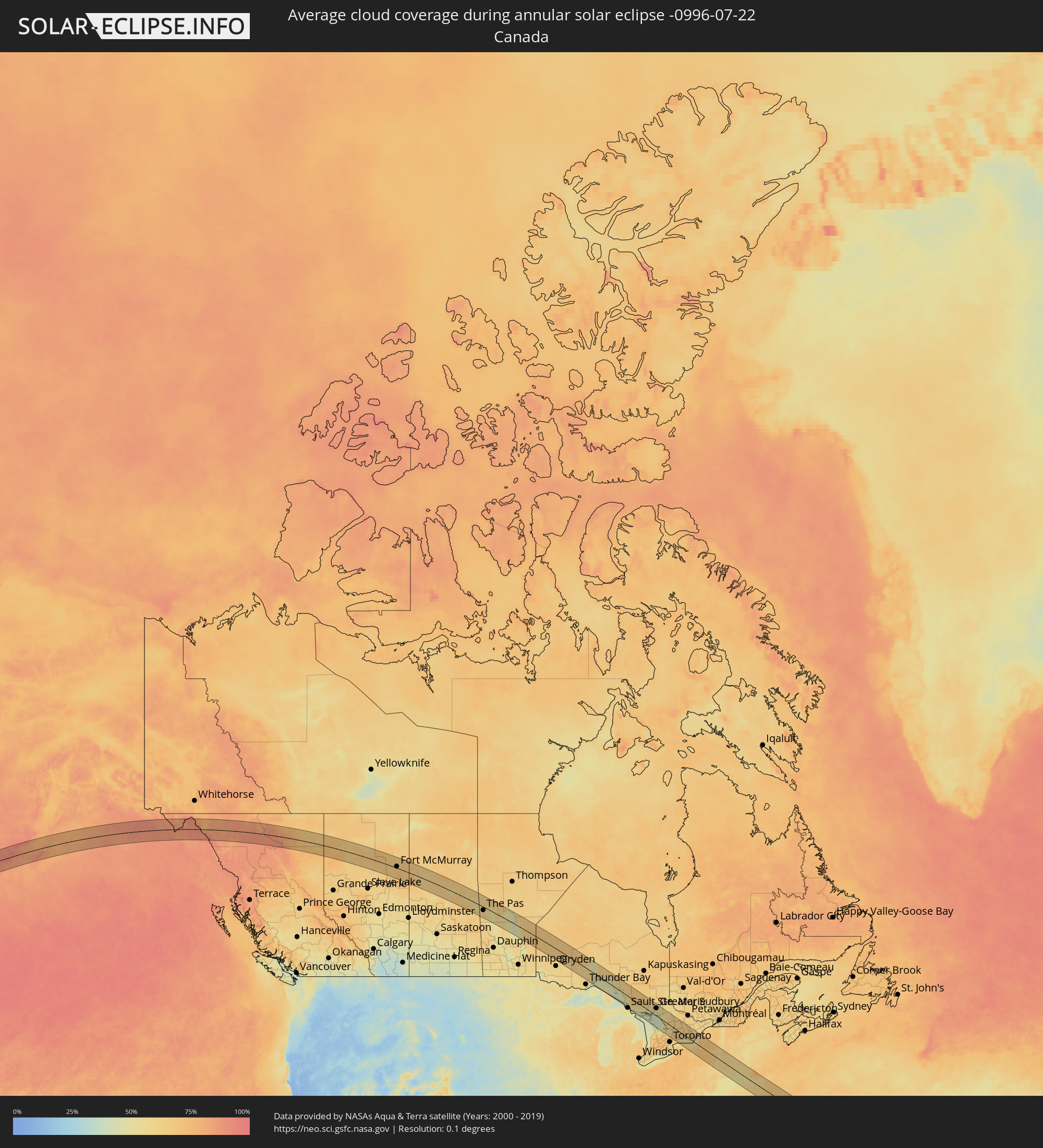 Canada
Cities inside the path of the eclipse
The following table shows all locations with a population of more than 5,000 inside the eclipse path. Cities which have more than 100,000 inhabitants are marked bold. A click at the locations opens a detailed map.
| City | Type | Eclipse duration | Local time of max. eclipse | Distance to central line | Ø Cloud coverage |
|
Fort McMurray, Alberta
|
annular | - | 13:40:18 UTC-07:33 | 11 km | 66% |
|
Flin Flon, Manitoba
|
annular | - | 15:28:03 UTC-06:00 | 56 km | 64% |
|
The Pas, Manitoba
|
annular | - | 15:30:14 UTC-06:00 | 23 km | 60% |
|
Elliot Lake, Ontario
|
annular | - | 16:58:26 UTC-05:00 | 26 km | 53% |
|
Rayside-Balfour, Ontario
|
annular | - | 16:58:43 UTC-05:00 | 59 km | 59% |
|
Greater Sudbury, Ontario
|
annular | - | 16:59:02 UTC-05:00 | 57 km | 55% |
|
Parry Sound, Ontario
|
annular | - | 17:01:29 UTC-05:00 | 6 km | 51% |
|
Wasaga Beach, Ontario
|
annular | - | 17:02:58 UTC-05:00 | 81 km | 55% |
|
Midland, Ontario
|
annular | - | 17:02:36 UTC-05:00 | 54 km | 52% |
|
Barrie, Ontario
|
annular | - | 17:03:19 UTC-05:00 | 77 km | 63% |
|
Innisfil, Ontario
|
annular | - | 17:03:30 UTC-05:00 | 84 km | 64% |
|
Keswick, Ontario
|
annular | - | 17:03:39 UTC-05:00 | 81 km | 59% |
|
Orillia, Ontario
|
annular | - | 17:03:02 UTC-05:00 | 47 km | 56% |
|
Gravenhurst, Ontario
|
annular | - | 17:02:31 UTC-05:00 | 28 km | 60% |
|
Bracebridge, Ontario
|
annular | - | 17:02:20 UTC-05:00 | 19 km | 60% |
|
Huntsville, Ontario
|
annular | - | 17:01:50 UTC-05:00 | 30 km | 61% |
|
Uxbridge, Ontario
|
annular | - | 17:04:03 UTC-05:00 | 79 km | 71% |
|
Oshawa, Ontario
|
annular | - | 17:04:30 UTC-05:00 | 88 km | 57% |
|
Peterborough, Ontario
|
annular | - | 17:04:00 UTC-05:00 | 28 km | 63% |
|
Cobourg, Ontario
|
annular | - | 17:04:38 UTC-05:00 | 52 km | 56% |
|
Irondequoit, New York
|
annular | - | 17:06:08 UTC-05:00 | 90 km | 72% |
|
Quinte West, Ontario
|
annular | - | 17:04:27 UTC-05:00 | 6 km | 63% |
|
Belleville, Ontario
|
annular | - | 17:04:32 UTC-05:00 | 9 km | 63% |
|
Prince Edward, Ontario
|
annular | - | 17:04:52 UTC-05:00 | 22 km | 56% |
|
Newark, New York
|
annular | - | 17:06:34 UTC-05:00 | 83 km | 72% |
|
Greater Napanee, Ontario
|
annular | - | 17:04:32 UTC-05:00 | 38 km | 71% |
|
Auburn, New York
|
annular | - | 17:06:55 UTC-05:00 | 70 km | 66% |
|
Oswego, New York
|
annular | - | 17:06:02 UTC-05:00 | 23 km | 54% |
|
Kingston, Ontario
|
annular | - | 17:04:43 UTC-05:00 | 55 km | 53% |
|
Fulton, New York
|
annular | - | 17:06:18 UTC-05:00 | 35 km | 60% |
|
Cortland, New York
|
annular | - | 17:07:36 UTC-05:00 | 83 km | 74% |
|
Gananoque, Ontario
|
annular | - | 17:04:38 UTC-05:00 | 80 km | 55% |
|
Syracuse, New York
|
annular | - | 17:06:50 UTC-05:00 | 42 km | 70% |
|
Watertown, New York
|
annular | - | 17:05:19 UTC-05:00 | 59 km | 65% |
|
Fort Drum, New York
|
annular | - | 17:05:13 UTC-05:00 | 74 km | 67% |
|
Oneida, New York
|
annular | - | 17:06:54 UTC-05:00 | 14 km | 68% |
|
Rome, New York
|
annular | - | 17:06:45 UTC-05:00 | 7 km | 64% |
|
Utica, New York
|
annular | - | 17:06:59 UTC-05:00 | 23 km | 67% |
|
Oneonta, New York
|
annular | - | 17:08:08 UTC-05:00 | 51 km | 71% |
|
Ilion, New York
|
annular | - | 17:07:11 UTC-05:00 | 13 km | 68% |
|
Herkimer, New York
|
annular | - | 17:07:11 UTC-05:00 | 14 km | 68% |
|
Johnstown, New York
|
annular | - | 17:07:21 UTC-05:00 | 41 km | 58% |
|
Gloversville, New York
|
annular | - | 17:07:17 UTC-05:00 | 46 km | 65% |
|
Amsterdam, New York
|
annular | - | 17:07:31 UTC-05:00 | 41 km | 58% |
|
Manorville, New York
|
annular | - | 17:08:53 UTC-05:00 | 29 km | 58% |
|
Newburgh, New York
|
annular | - | 17:09:57 UTC-05:00 | 83 km | 56% |
|
Kingston, New York
|
annular | - | 17:09:15 UTC-05:00 | 48 km | 53% |
|
Scotia, New York
|
annular | - | 17:07:45 UTC-05:00 | 48 km | 61% |
|
Schenectady, New York
|
annular | - | 17:07:46 UTC-05:00 | 47 km | 62% |
|
Poughkeepsie, New York
|
annular | - | 17:09:38 UTC-05:00 | 61 km | 58% |
|
Colonie, New York
|
annular | - | 17:07:57 UTC-05:00 | 38 km | 62% |
|
Delmar, New York
|
annular | - | 17:08:07 UTC-05:00 | 28 km | 55% |
|
Jefferson Valley-Yorktown, New York
|
annular | - | 17:10:18 UTC-05:00 | 92 km | 57% |
|
Saratoga Springs, New York
|
annular | - | 17:07:21 UTC-05:00 | 76 km | 61% |
|
Oakdale, New York
|
annular | - | 17:08:45 UTC-05:00 | 24 km | 57% |
|
Albany, New York
|
annular | - | 17:08:05 UTC-05:00 | 35 km | 62% |
|
Mahopac, New York
|
annular | - | 17:10:13 UTC-05:00 | 84 km | 56% |
|
Lake Carmel, New York
|
annular | - | 17:10:05 UTC-05:00 | 74 km | 55% |
|
Ridgefield, Connecticut
|
annular | - | 17:10:25 UTC-05:00 | 80 km | 59% |
|
Danbury, Connecticut
|
annular | - | 17:10:14 UTC-05:00 | 67 km | 59% |
|
Norwalk, Connecticut
|
annular | - | 17:10:42 UTC-05:00 | 93 km | 61% |
|
Pittsfield, Massachusetts
|
annular | - | 17:08:31 UTC-05:00 | 40 km | 60% |
|
Southbury, Connecticut
|
annular | - | 17:10:08 UTC-05:00 | 49 km | 61% |
|
Bridgeport, Connecticut
|
annular | - | 17:10:39 UTC-05:00 | 79 km | 58% |
|
Bennington, Vermont
|
annular | - | 17:07:49 UTC-05:00 | 85 km | 65% |
|
Torrington, Connecticut
|
annular | - | 17:09:37 UTC-05:00 | 14 km | 63% |
|
North Adams, Massachusetts
|
annular | - | 17:08:08 UTC-05:00 | 70 km | 63% |
|
Port Jefferson, New York
|
annular | - | 17:11:02 UTC-05:00 | 91 km | 60% |
|
Winsted, Connecticut
|
annular | - | 17:09:26 UTC-05:00 | 6 km | 60% |
|
Waterbury, Connecticut
|
annular | - | 17:10:02 UTC-05:00 | 37 km | 62% |
|
Port Jefferson Station, New York
|
annular | - | 17:11:04 UTC-05:00 | 92 km | 62% |
|
Coram, New York
|
annular | - | 17:11:10 UTC-05:00 | 95 km | 62% |
|
Sound Beach, New York
|
annular | - | 17:11:02 UTC-05:00 | 85 km | 55% |
|
Bristol, Connecticut
|
annular | - | 17:09:52 UTC-05:00 | 25 km | 63% |
|
New Haven, Connecticut
|
annular | - | 17:10:28 UTC-05:00 | 51 km | 59% |
|
Wading River, New York
|
annular | - | 17:11:04 UTC-05:00 | 82 km | 56% |
|
Mastic, New York
|
annular | - | 17:11:18 UTC-05:00 | 96 km | 61% |
|
Meriden, Connecticut
|
annular | - | 17:10:06 UTC-05:00 | 28 km | 59% |
|
Center Moriches, New York
|
annular | - | 17:11:19 UTC-05:00 | 93 km | 61% |
|
Southwick, Massachusetts
|
annular | - | 17:09:16 UTC-05:00 | 26 km | 60% |
|
Kensington, Connecticut
|
annular | - | 17:09:57 UTC-05:00 | 22 km | 61% |
|
Hartford, Connecticut
|
annular | - | 17:09:45 UTC-05:00 | 21 km | 63% |
|
Guilford, Connecticut
|
annular | - | 17:10:32 UTC-05:00 | 42 km | 57% |
|
Northampton, Massachusetts
|
annular | - | 17:08:50 UTC-05:00 | 57 km | 59% |
|
Windsor Locks, Connecticut
|
annular | - | 17:09:30 UTC-05:00 | 31 km | 60% |
|
Greenfield, Massachusetts
|
annular | - | 17:08:24 UTC-05:00 | 84 km | 59% |
|
Thompsonville, Connecticut
|
annular | - | 17:09:23 UTC-05:00 | 35 km | 58% |
|
Springfield, Massachusetts
|
annular | - | 17:09:13 UTC-05:00 | 41 km | 61% |
|
Southwood Acres, Connecticut
|
annular | - | 17:09:27 UTC-05:00 | 36 km | 58% |
|
Montague, Massachusetts
|
annular | - | 17:08:30 UTC-05:00 | 81 km | 59% |
|
Hampton Bays, New York
|
annular | - | 17:11:15 UTC-05:00 | 72 km | 59% |
|
East Haddam, Connecticut
|
annular | - | 17:10:18 UTC-05:00 | 21 km | 56% |
|
Rockville, Connecticut
|
annular | - | 17:09:37 UTC-05:00 | 26 km | 58% |
|
Old Saybrook, Connecticut
|
annular | - | 17:10:35 UTC-05:00 | 33 km | 56% |
|
Tolland, Connecticut
|
annular | - | 17:09:38 UTC-05:00 | 28 km | 58% |
|
Hebron, Connecticut
|
annular | - | 17:09:59 UTC-05:00 | 11 km | 59% |
|
Palmer, Massachusetts
|
annular | - | 17:09:10 UTC-05:00 | 60 km | 61% |
|
Monson, Massachusetts
|
annular | - | 17:09:15 UTC-05:00 | 54 km | 59% |
|
Mansfield City, Connecticut
|
annular | - | 17:09:49 UTC-05:00 | 26 km | 56% |
|
New London, Connecticut
|
annular | - | 17:10:31 UTC-05:00 | 9 km | 54% |
|
Norwich, Connecticut
|
annular | - | 17:10:15 UTC-05:00 | 17 km | 54% |
|
Southbridge, Massachusetts
|
annular | - | 17:09:21 UTC-05:00 | 62 km | 61% |
|
Plainfield, Connecticut
|
annular | - | 17:10:01 UTC-05:00 | 33 km | 58% |
|
Killingly Center, Connecticut
|
annular | - | 17:09:45 UTC-05:00 | 52 km | 59% |
|
Westerly, Rhode Island
|
annular | - | 17:10:31 UTC-05:00 | 14 km | 57% |
|
Worcester, Massachusetts
|
annular | - | 17:09:04 UTC-05:00 | 90 km | 60% |
|
Hopkinton, Rhode Island
|
annular | - | 17:10:23 UTC-05:00 | 20 km | 56% |
|
Hamilton, Massachusetts
|
annular | - | 17:09:05 UTC-05:00 | 92 km | 60% |
|
Coventry, Rhode Island
|
annular | - | 17:10:01 UTC-05:00 | 44 km | 59% |
|
Charlestown, Rhode Island
|
annular | - | 17:10:32 UTC-05:00 | 30 km | 60% |
|
Greenville, Rhode Island
|
annular | - | 17:09:45 UTC-05:00 | 66 km | 57% |
|
Milford, Massachusetts
|
annular | - | 17:09:19 UTC-05:00 | 93 km | 60% |
|
Woonsocket, Rhode Island
|
annular | - | 17:09:32 UTC-05:00 | 80 km | 59% |
|
Wakefield-Peacedale, Rhode Island
|
annular | - | 17:10:27 UTC-05:00 | 35 km | 60% |
|
Cumberland Hill, Rhode Island
|
annular | - | 17:09:35 UTC-05:00 | 79 km | 59% |
|
North Kingstown, Rhode Island
|
annular | - | 17:10:17 UTC-05:00 | 47 km | 57% |
|
Providence, Rhode Island
|
annular | - | 17:09:51 UTC-05:00 | 69 km | 62% |
|
Plainville, Massachusetts
|
annular | - | 17:09:34 UTC-05:00 | 89 km | 61% |
|
Newport East, Rhode Island
|
annular | - | 17:10:22 UTC-05:00 | 46 km | 61% |
|
Attleboro, Massachusetts
|
annular | - | 17:09:40 UTC-05:00 | 86 km | 59% |
|
Tiverton, Rhode Island
|
annular | - | 17:10:11 UTC-05:00 | 60 km | 53% |
|
Fall River, Massachusetts
|
annular | - | 17:10:05 UTC-05:00 | 70 km | 55% |
|
Taunton, Massachusetts
|
annular | - | 17:09:46 UTC-05:00 | 92 km | 61% |
|
Freetown, Massachusetts
|
annular | - | 17:09:59 UTC-05:00 | 81 km | 57% |
|
New Bedford, Massachusetts
|
annular | - | 17:10:12 UTC-05:00 | 74 km | 60% |
|
Mashpee, Massachusetts
|
annular | - | 17:10:14 UTC-05:00 | 96 km | 59% |