Total solar eclipse of 02/12/-1258
| Day of week: | Wednesday |
| Maximum duration of eclipse: | 04m11s |
| Maximum width of eclipse path: | 174 km |
| Saros cycle: | 20 |
| Coverage: | 100% |
| Magnitude: | 1.0438 |
| Gamma: | 0.543 |
Wo kann man die Sonnenfinsternis vom 02/12/-1258 sehen?

Die Sonnenfinsternis am 02/12/-1258 kann man in 50 Ländern als partielle Sonnenfinsternis beobachten.
Der Finsternispfad verläuft durch 5 Länder. Nur in diesen Ländern ist sie als total Sonnenfinsternis zu sehen.
In den folgenden Ländern ist die Sonnenfinsternis total zu sehen
 Mexico
 Guatemala
 Belize
 Cuba
Cuba
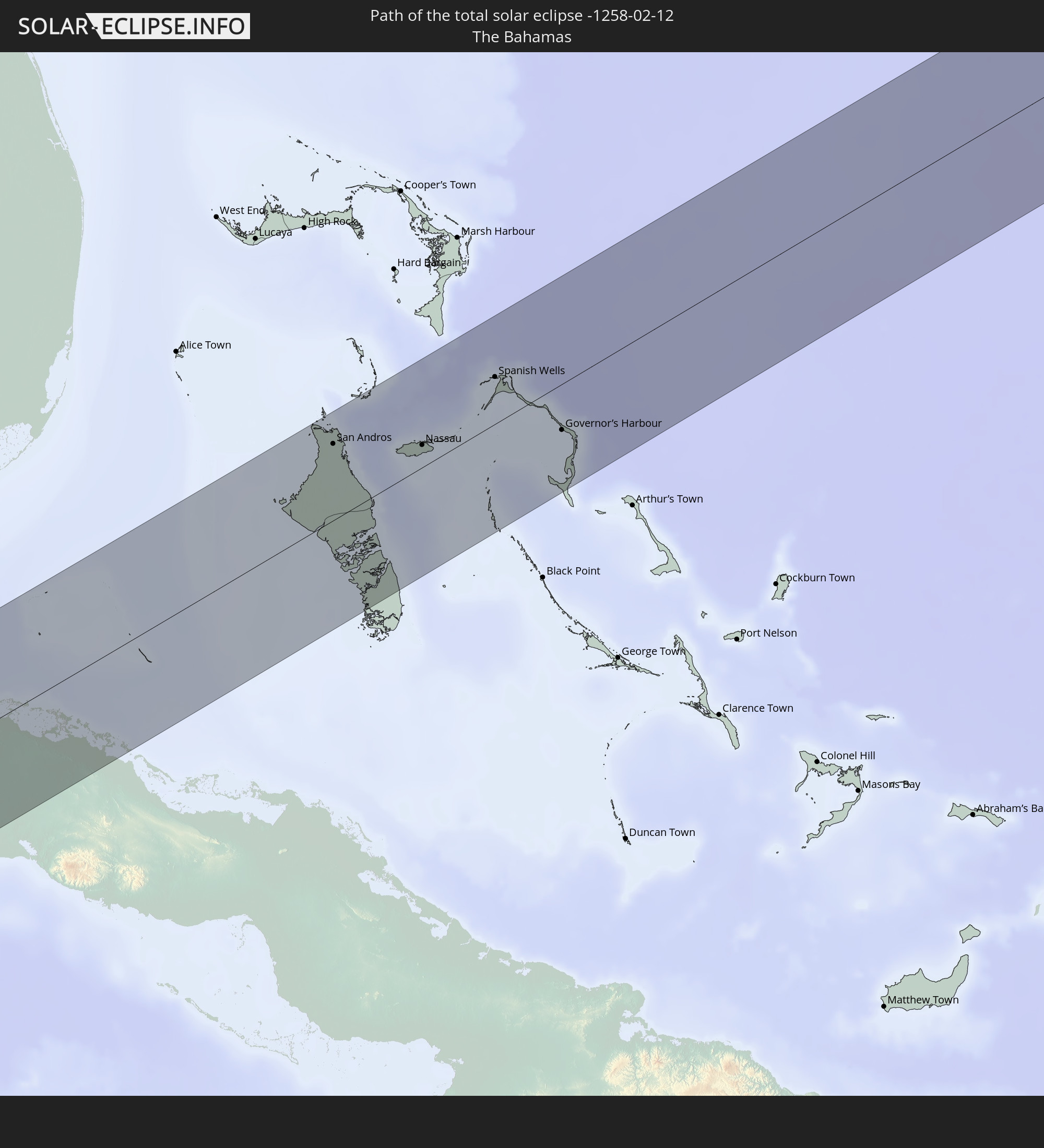 The Bahamas
In den folgenden Ländern ist die Sonnenfinsternis partiell zu sehen
 United States
 United States Minor Outlying Islands
 Kiribati
 Cook Islands
 French Polynesia
 Canada
 Mexico
 Greenland
 Guatemala
 Ecuador
 El Salvador
 Honduras
 Belize
 Nicaragua
 Costa Rica
 Cuba
Cuba
 Panama
 Colombia
 Cayman Islands
 Peru
Peru
 The Bahamas
 Jamaica
 Haiti
Haiti
 Brazil
 Venezuela
 Turks and Caicos Islands
 Dominican Republic
 Aruba
Aruba
 Puerto Rico
 United States Virgin Islands
 Bermuda
 British Virgin Islands
 Anguilla
 Collectivity of Saint Martin
 Saint Barthélemy
 Saint Kitts and Nevis
 Antigua and Barbuda
 Montserrat
 Trinidad and Tobago
 Guadeloupe
 Grenada
 Dominica
 Saint Vincent and the Grenadines
 Guyana
 Martinique
 Saint Lucia
 Barbados
 Suriname
 Saint Pierre and Miquelon
 French Guiana
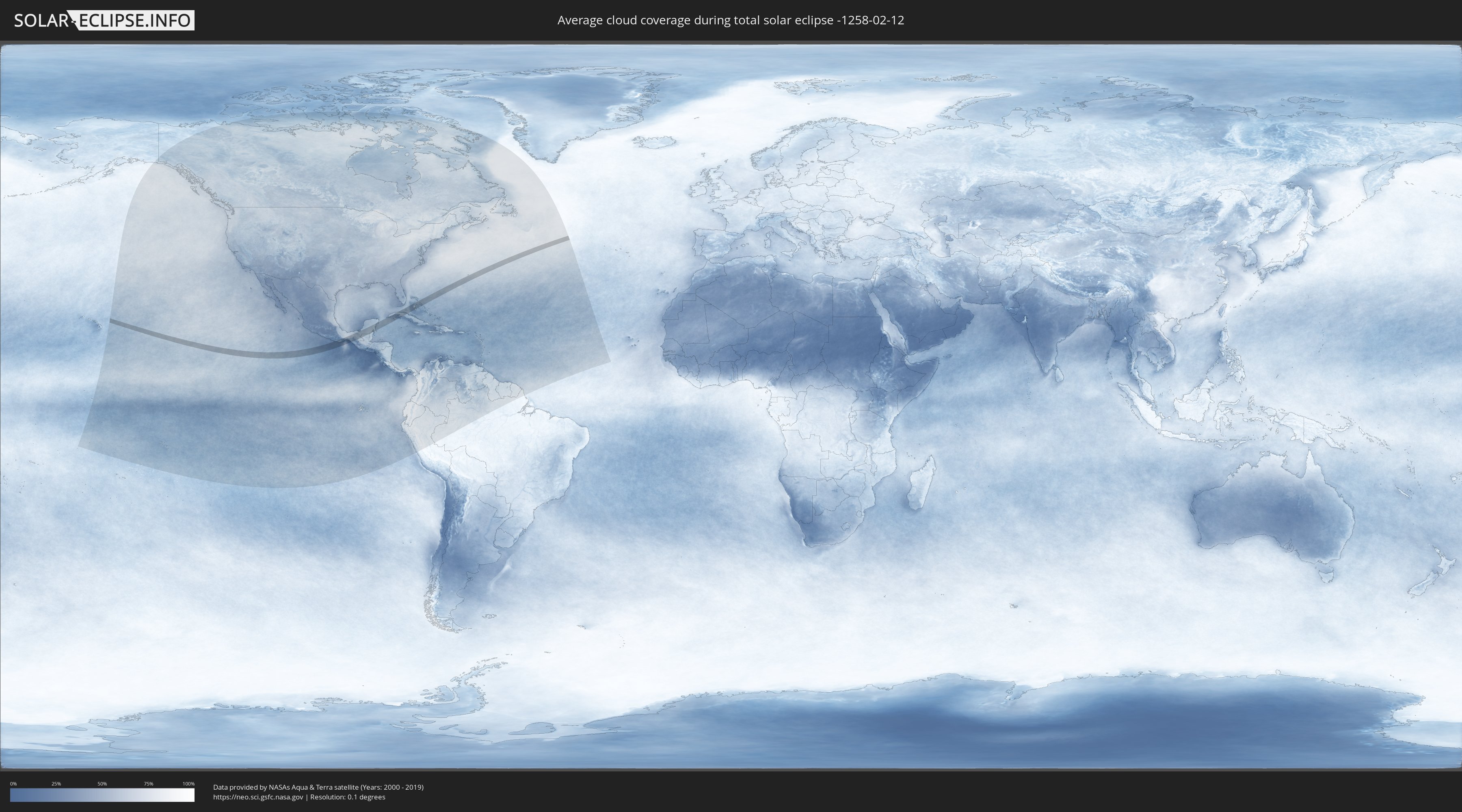
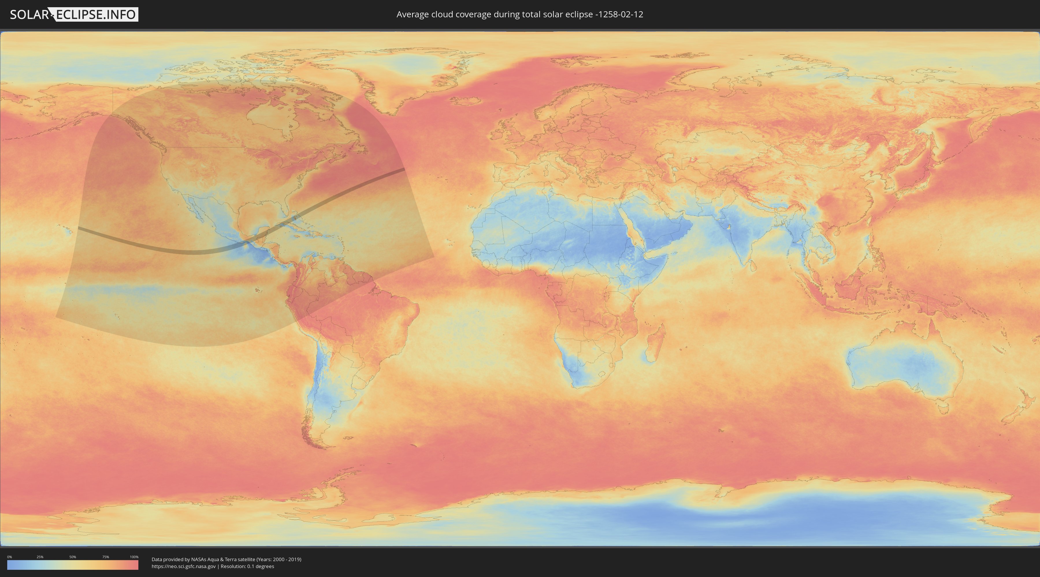
How will be the weather during the total solar eclipse on 02/12/-1258?
Where is the best place to see the total solar eclipse of 02/12/-1258?
The following maps show the average cloud coverage for the day of the total solar eclipse.
With the help of these maps, it is possible to find the place along the eclipse path, which has the best
chance of a cloudless sky.
Nevertheless, you should consider local circumstances and inform about the weather of your chosen
observation site.
The data is provided by NASAs satellites
AQUA and TERRA.
The cloud maps are averaged over a period of 19 years (2000 - 2019).
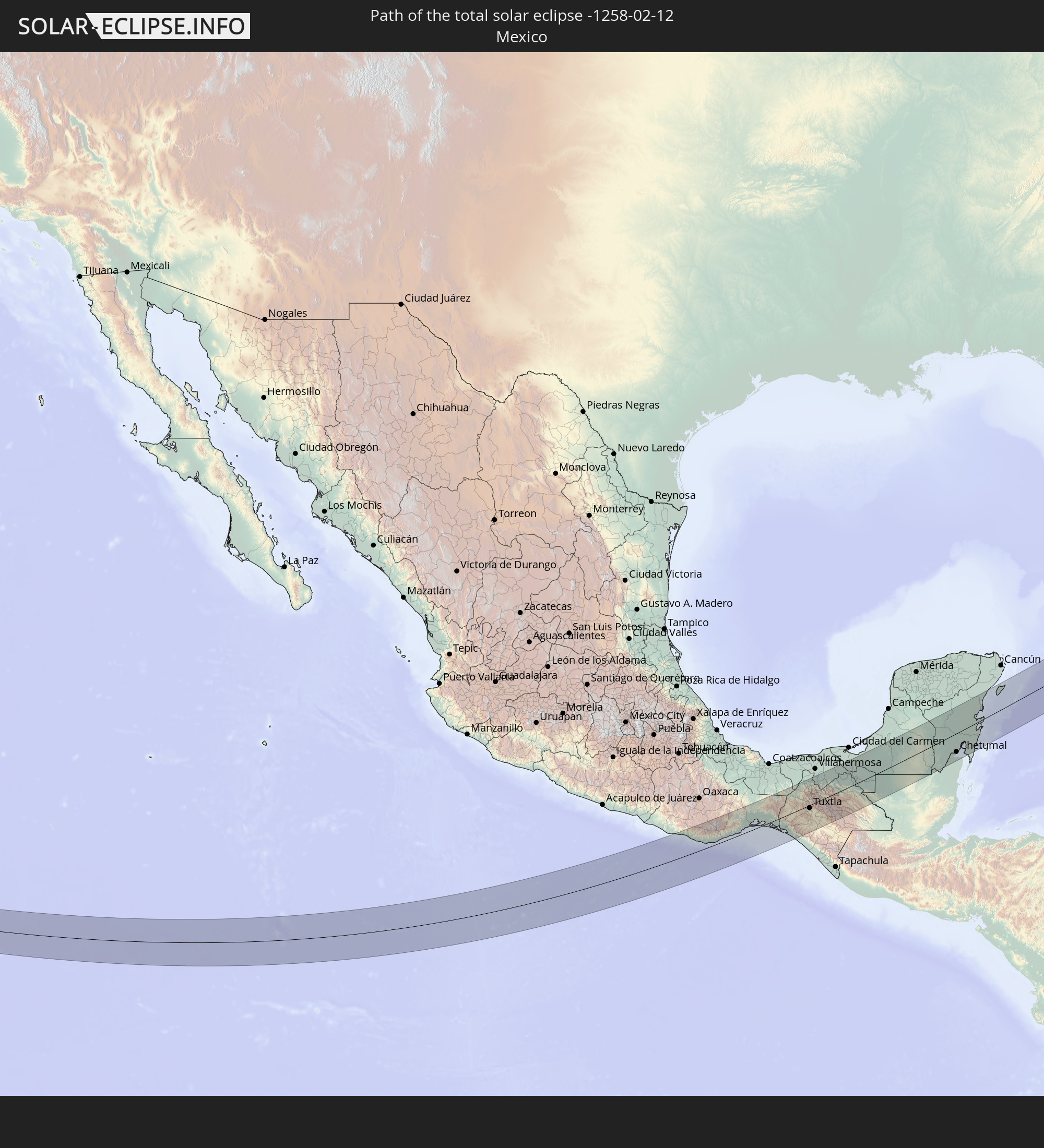
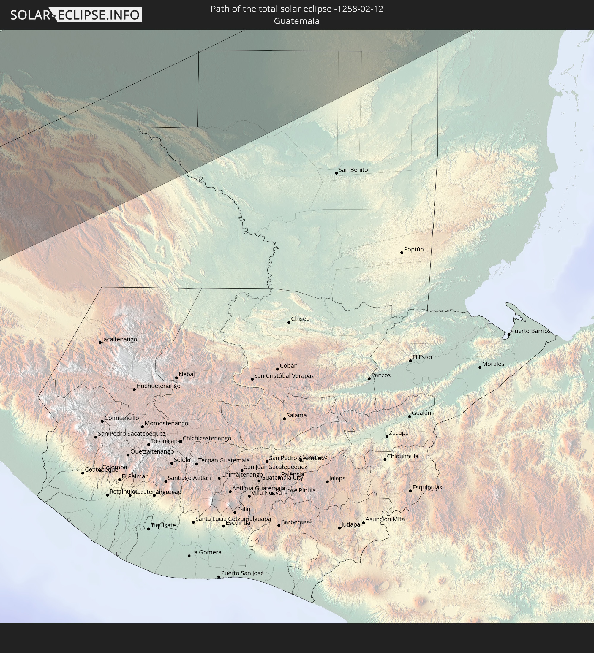
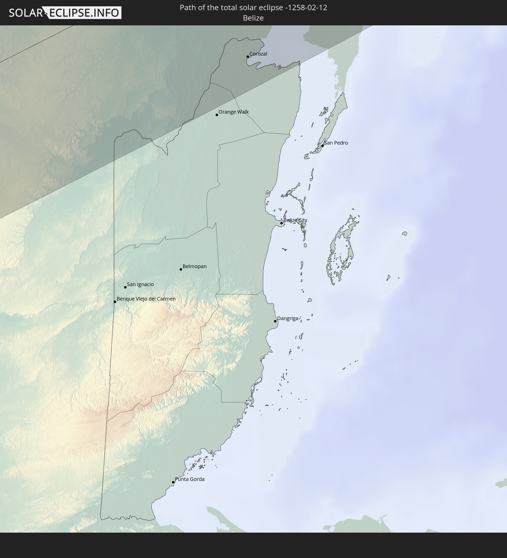
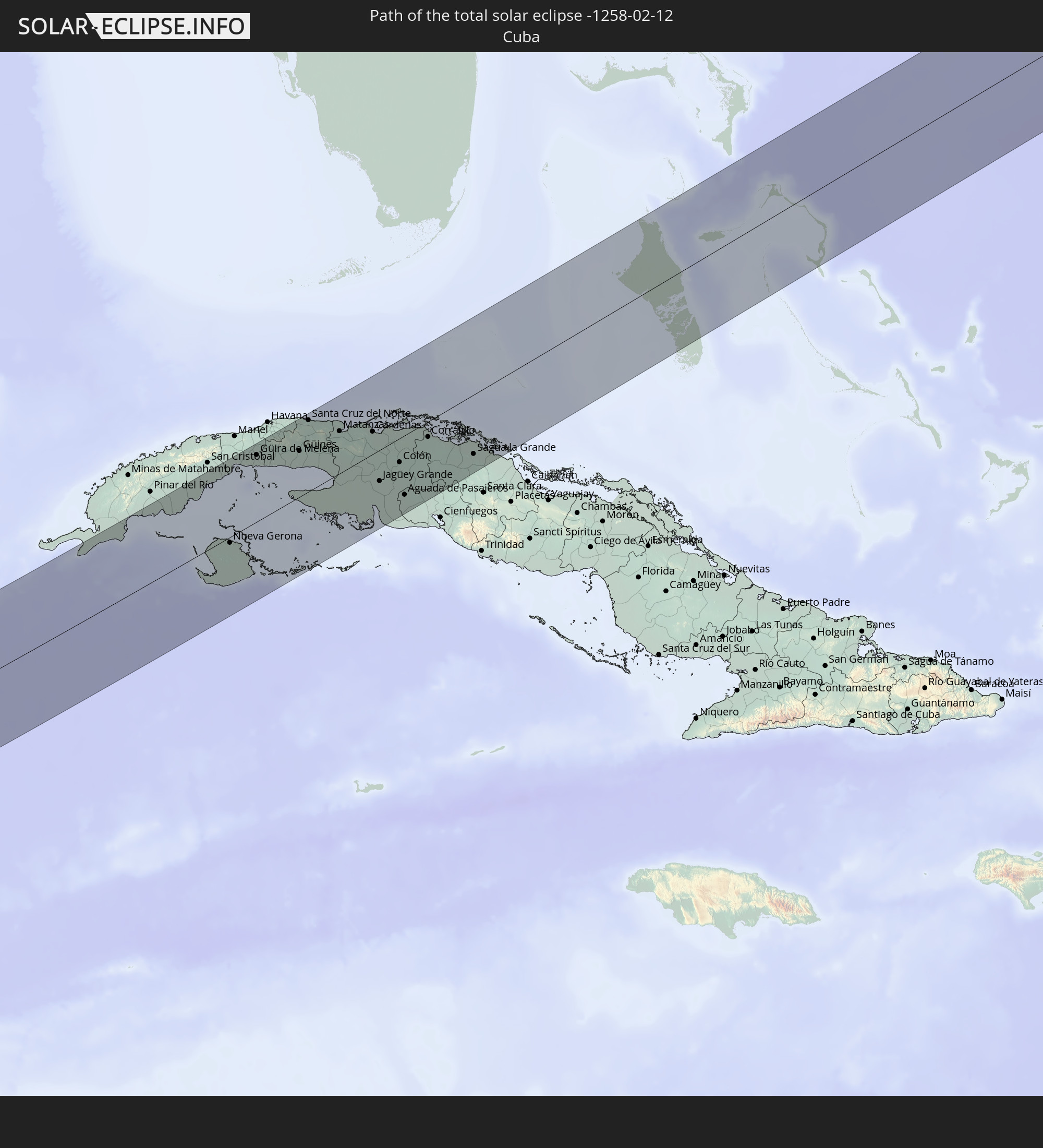
Detailed country maps
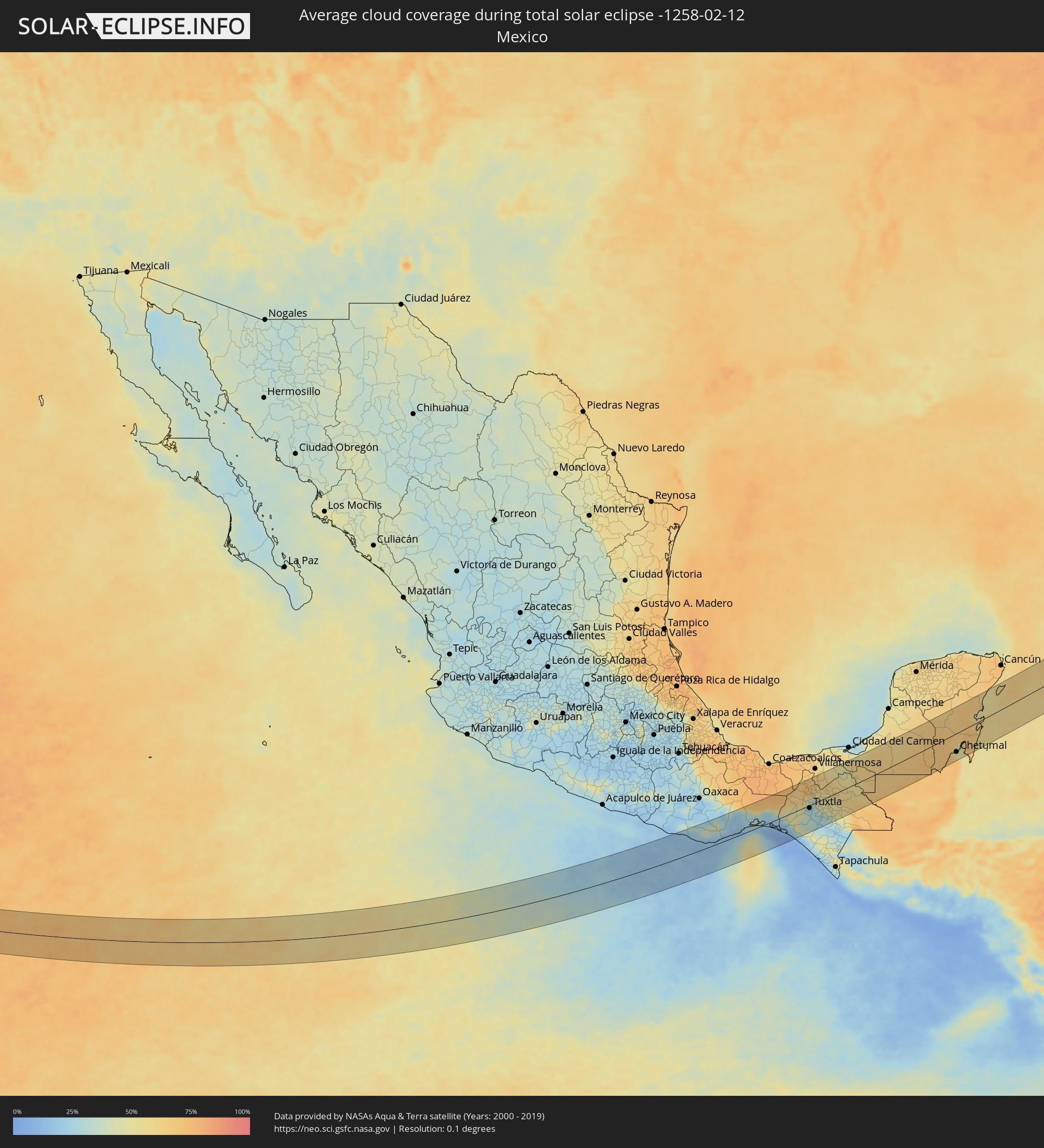 Mexico
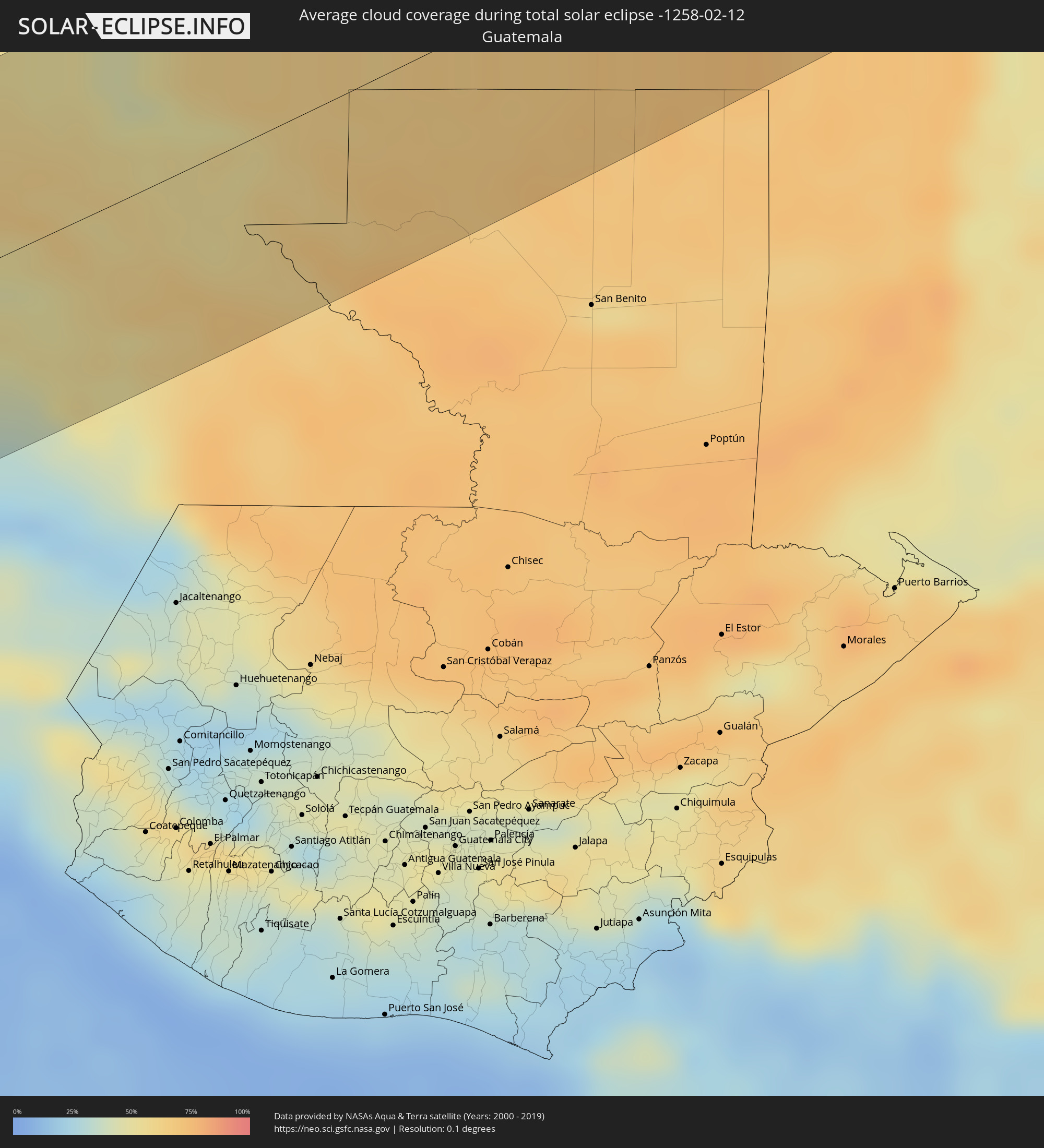 Guatemala
 Belize
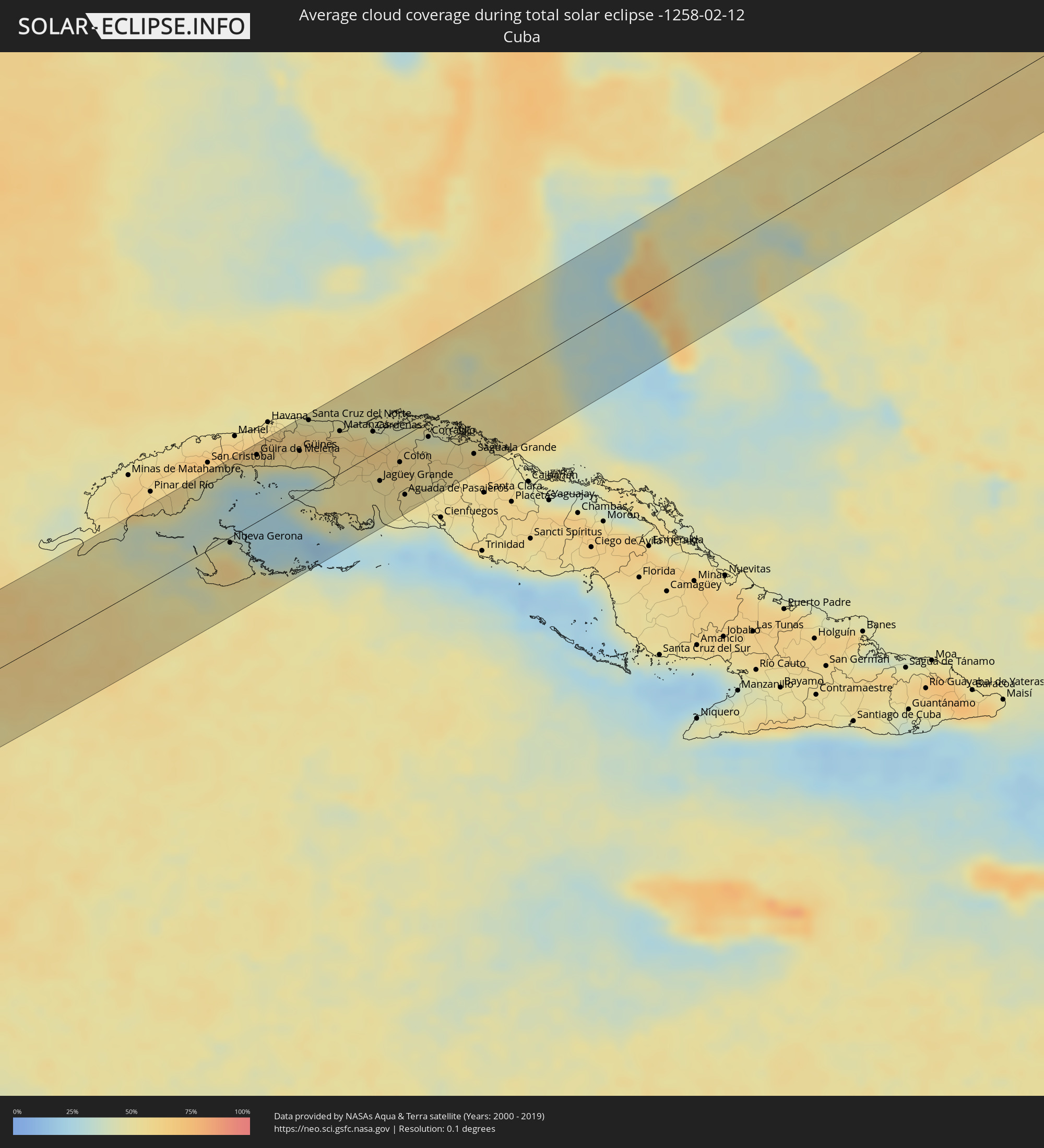 Cuba
Cuba
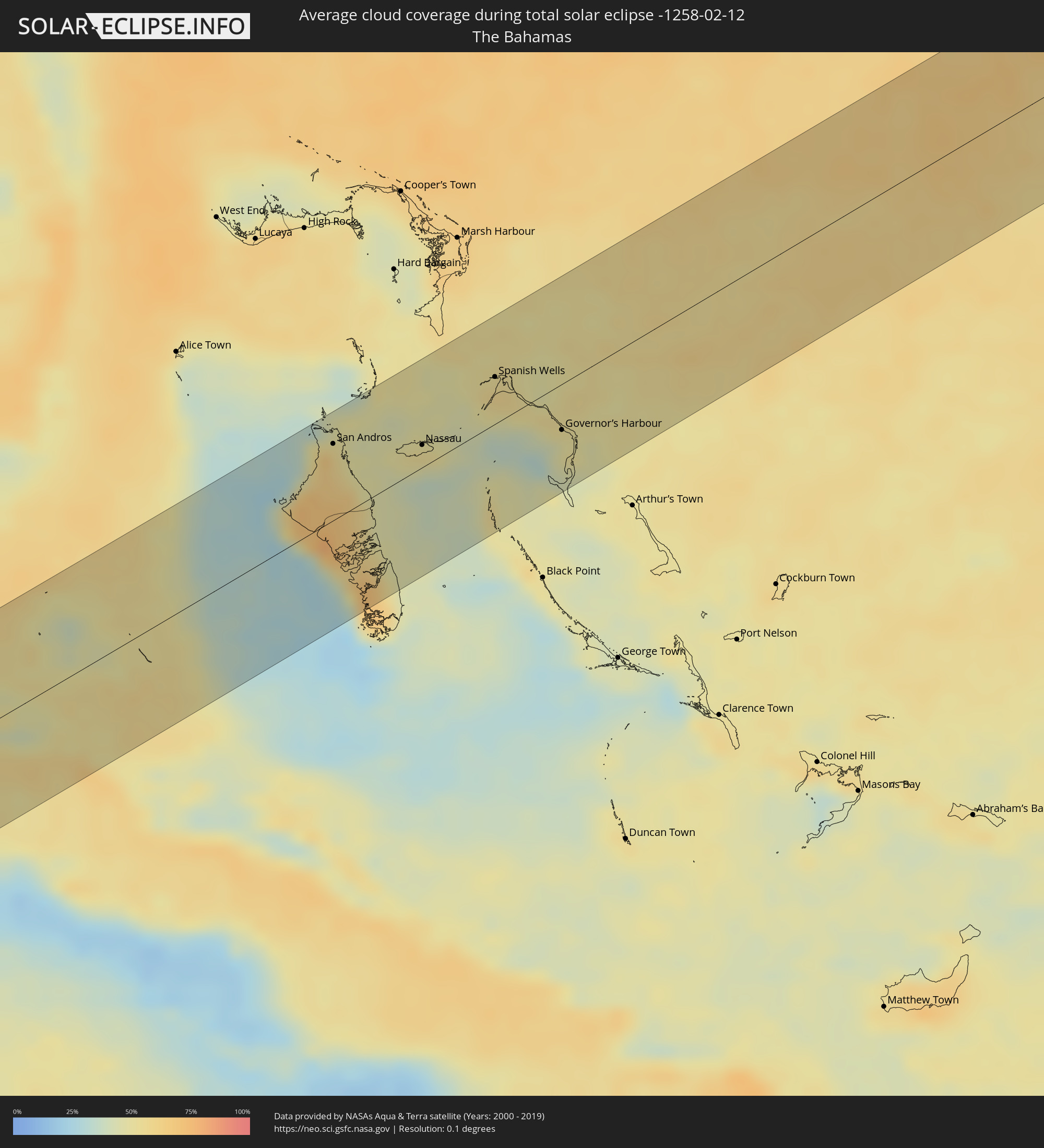 The Bahamas
Cities inside the path of the eclipse
The following table shows all locations with a population of more than 5,000 inside the eclipse path. Cities which have more than 100,000 inhabitants are marked bold. A click at the locations opens a detailed map.
| City | Type | Eclipse duration | Local time of max. eclipse | Distance to central line | Ø Cloud coverage |
|
Puerto Escondido, Oaxaca
|
total | - | 11:54:03 UTC-06:36 | 60 km | 18% |
|
Brisas de Zicatela, Oaxaca
|
total | - | 11:54:08 UTC-06:36 | 55 km | 18% |
|
San Pedro Pochutla, Oaxaca
|
total | - | 11:55:44 UTC-06:36 | 24 km | 16% |
|
Crucecita, Oaxaca
|
total | - | 11:56:43 UTC-06:36 | 14 km | 16% |
|
Jalapa, Oaxaca
|
total | - | 11:59:18 UTC-06:36 | 63 km | 18% |
|
Santo Domingo Tehuantepec, Oaxaca
|
total | - | 11:59:48 UTC-06:36 | 36 km | 23% |
|
Salina Cruz, Oaxaca
|
total | - | 11:59:47 UTC-06:36 | 20 km | 22% |
|
San Jerónimo Ixtepec, Oaxaca
|
total | - | 12:00:25 UTC-06:36 | 56 km | 32% |
|
Colonia Rincón Viejo, Oaxaca
|
total | - | 12:00:50 UTC-06:36 | 86 km | 70% |
|
El Espinal, Oaxaca
|
total | - | 12:00:31 UTC-06:36 | 44 km | 28% |
|
Matías Romero, Oaxaca
|
total | - | 12:00:51 UTC-06:36 | 84 km | 70% |
|
Juchitán de Zaragoza, Oaxaca
|
total | - | 12:00:32 UTC-06:36 | 38 km | 29% |
|
Unión Hidalgo, Oaxaca
|
total | - | 12:01:07 UTC-06:36 | 34 km | 31% |
|
Las Amilpas, Oaxaca
|
total | - | 12:01:38 UTC-06:36 | 14 km | 22% |
|
Chahuite, Oaxaca
|
total | - | 12:02:49 UTC-06:36 | 10 km | 19% |
|
El Espinal, Chiapas
|
total | - | 12:03:06 UTC-06:36 | 7 km | 21% |
|
Arriaga, Chiapas
|
total | - | 12:03:34 UTC-06:36 | 29 km | 17% |
|
Tonalá, Chiapas
|
total | - | 12:03:51 UTC-06:36 | 50 km | 15% |
|
Cintalapa de Figueroa, Chiapas
|
total | - | 12:04:28 UTC-06:36 | 9 km | 47% |
|
Jiquipilas, Chiapas
|
total | - | 12:04:39 UTC-06:36 | 4 km | 46% |
|
Ocozocoautla de Espinosa, Chiapas
|
total | - | 12:05:30 UTC-06:36 | 2 km | 43% |
|
Villa Corzo, Chiapas
|
total | - | 12:05:19 UTC-06:36 | 61 km | 37% |
|
San Fernando, Chiapas
|
total | - | 12:06:04 UTC-06:36 | 6 km | 41% |
|
San Pedro Buenavista, Chiapas
|
total | - | 12:05:40 UTC-06:36 | 78 km | 37% |
|
Pichucalco, Chiapas
|
total | - | 12:06:51 UTC-06:36 | 67 km | 68% |
|
Tuxtla, Chiapas
|
total | - | 12:06:14 UTC-06:36 | 9 km | 29% |
|
Teapa, Tabasco
|
total | - | 12:07:20 UTC-06:36 | 64 km | 66% |
|
Río de Teapa, Tabasco
|
total | - | 12:07:40 UTC-06:36 | 85 km | 61% |
|
Pueblo Nuevo Jolistahuacan, Chiapas
|
total | - | 12:07:10 UTC-06:36 | 22 km | 47% |
|
Bochil, Chiapas
|
total | - | 12:07:03 UTC-06:36 | 5 km | 40% |
|
Acala, Chiapas
|
total | - | 12:06:56 UTC-06:36 | 43 km | 26% |
|
Simojovel de Allende, Chiapas
|
total | - | 12:07:40 UTC-06:36 | 12 km | 53% |
|
San Cristóbal de las Casas, Chiapas
|
total | - | 12:07:33 UTC-06:36 | 33 km | 43% |
|
Simojovel de Allende, Chiapas
|
total | - | 12:07:57 UTC-06:36 | 14 km | 47% |
|
Macuspana, Tabasco
|
total | - | 12:08:30 UTC-06:36 | 69 km | 60% |
|
Venustiano Carranza, Chiapas
|
total | - | 12:07:26 UTC-06:36 | 76 km | 30% |
|
Teopisca, Chiapas
|
total | - | 12:07:51 UTC-06:36 | 60 km | 37% |
|
Yajalón, Chiapas
|
total | - | 12:08:46 UTC-06:36 | 2 km | 56% |
|
Ocosingo, Chiapas
|
total | - | 12:09:13 UTC-06:36 | 40 km | 55% |
|
Palenque, Chiapas
|
total | - | 12:10:00 UTC-06:36 | 16 km | 57% |
|
Emiliano Zapata, Chiapas
|
total | - | 12:10:47 UTC-06:36 | 30 km | 54% |
|
Balancán de Domínguez, Tabasco
|
total | - | 12:11:28 UTC-06:36 | 26 km | 53% |
|
Tenosique de Pino Suárez, Tabasco
|
total | - | 12:11:31 UTC-06:36 | 13 km | 60% |
|
San Carlos, Tabasco
|
total | - | 12:12:19 UTC-06:36 | 17 km | 60% |
|
Escárcega, Campeche
|
total | - | 12:14:14 UTC-06:36 | 69 km | 62% |
|
Bacalar, Quintana Roo
|
total | - | 13:10:02 UTC-05:47 | 36 km | 64% |
|
Corozal, Corozal
|
total | - | 13:04:07 UTC-05:52 | 65 km | 61% |
|
Chetumal, Quintana Roo
|
total | - | 13:10:09 UTC-05:47 | 57 km | 49% |
|
Felipe Carrillo Puerto, Quintana Roo
|
total | - | 13:11:33 UTC-05:47 | 35 km | 70% |
|
Tulum, Quintana Roo
|
total | - | 13:13:26 UTC-05:47 | 69 km | 57% |
|
San Miguel de Cozumel, Quintana Roo
|
total | - | 13:14:55 UTC-05:47 | 71 km | 64% |
|
Nueva Gerona, Isla de la Juventud
|
total | - | 13:42:54 UTC-05:29 | 6 km | 51% |
|
Alquízar, Artemisa
|
total | - | 13:43:49 UTC-05:29 | 71 km | 55% |
|
Güira de Melena, Artemisa
|
total | - | 13:43:59 UTC-05:29 | 67 km | 55% |
|
San Antonio de los Baños, Artemisa
|
total | - | 13:44:02 UTC-05:29 | 75 km | 63% |
|
La Salud, Mayabeque
|
total | - | 13:44:12 UTC-05:29 | 70 km | 62% |
|
Bejucal, Mayabeque
|
total | - | 13:44:18 UTC-05:29 | 73 km | 62% |
|
Santiago de las Vegas, La Habana
|
total | - | 13:44:20 UTC-05:29 | 77 km | 65% |
|
Quivicán, Mayabeque
|
total | - | 13:44:20 UTC-05:29 | 61 km | 52% |
|
Arroyo Naranjo, La Habana
|
total | - | 13:44:32 UTC-05:29 | 77 km | 65% |
|
Batabanó, Mayabeque
|
total | - | 13:44:26 UTC-05:29 | 48 km | 36% |
|
Jamaica, Mayabeque
|
total | - | 13:44:48 UTC-05:29 | 66 km | 63% |
|
San José de las Lajas, Mayabeque
|
total | - | 13:44:50 UTC-05:29 | 64 km | 63% |
|
Güines, Mayabeque
|
total | - | 13:45:03 UTC-05:29 | 46 km | 52% |
|
Jaruco, Mayabeque
|
total | - | 13:45:11 UTC-05:29 | 65 km | 62% |
|
Santa Cruz del Norte, Mayabeque
|
total | - | 13:45:24 UTC-05:29 | 71 km | 54% |
|
San Nicolás de Bari, Mayabeque
|
total | - | 13:45:17 UTC-05:29 | 35 km | 51% |
|
Madruga, Mayabeque
|
total | - | 13:45:27 UTC-05:29 | 44 km | 60% |
|
Matanzas, Matanzas
|
total | - | 13:46:06 UTC-05:29 | 42 km | 60% |
|
Alacranes, Matanzas
|
total | - | 13:46:01 UTC-05:29 | 15 km | 57% |
|
Unión de Reyes, Matanzas
|
total | - | 13:46:06 UTC-05:29 | 16 km | 57% |
|
Bolondrón, Matanzas
|
total | - | 13:46:16 UTC-05:29 | 9 km | 58% |
|
Pedro Betancourt, Matanzas
|
total | - | 13:46:36 UTC-05:29 | 3 km | 58% |
|
Varadero, Matanzas
|
total | - | 13:46:52 UTC-05:29 | 36 km | 48% |
|
Cárdenas, Matanzas
|
total | - | 13:46:54 UTC-05:29 | 22 km | 62% |
|
Jovellanos, Matanzas
|
total | - | 13:46:50 UTC-05:29 | 1 km | 60% |
|
Jagüey Grande, Matanzas
|
total | - | 13:46:51 UTC-05:29 | 31 km | 53% |
|
Perico, Matanzas
|
total | - | 13:47:11 UTC-05:29 | 13 km | 61% |
|
Martí, Matanzas
|
total | - | 13:47:28 UTC-05:29 | 1 km | 61% |
|
Calimete, Matanzas
|
total | - | 13:47:19 UTC-05:29 | 41 km | 56% |
|
Colón, Matanzas
|
total | - | 13:47:24 UTC-05:29 | 24 km | 60% |
|
Aguada de Pasajeros, Cienfuegos
|
total | - | 13:47:23 UTC-05:29 | 59 km | 53% |
|
Los Arabos, Matanzas
|
total | - | 13:47:48 UTC-05:29 | 32 km | 56% |
|
Corralillo, Villa Clara
|
total | - | 13:48:11 UTC-05:29 | 15 km | 51% |
|
Quemado de Güines, Villa Clara
|
total | - | 13:48:48 UTC-05:29 | 51 km | 57% |
|
Santo Domingo, Villa Clara
|
total | - | 13:48:44 UTC-05:29 | 71 km | 56% |
|
Sagua la Grande, Villa Clara
|
total | - | 13:49:10 UTC-05:29 | 59 km | 58% |
|
Cifuentes, Villa Clara
|
total | - | 13:49:10 UTC-05:29 | 75 km | 57% |
|
San Andros, North Andros
|
total | - | 14:14:02 UTC-05:09 | 53 km | 64% |
|
Nassau, New Providence
|
total | - | 14:15:22 UTC-05:09 | 15 km | 53% |
|
Spanish Wells, Spanish Wells
|
total | - | 14:16:33 UTC-05:09 | 32 km | 53% |
|
Governor’s Harbour, Central Eleuthera
|
total | - | 19:26:56 UTC+00:00 | 32 km | 49% |