Annular solar eclipse of 12/21/-1284
| Day of week: | Wednesday |
| Maximum duration of eclipse: | 07m16s |
| Maximum width of eclipse path: | 340 km |
| Saros cycle: | 21 |
| Coverage: | 92.5% |
| Magnitude: | 0.9249 |
| Gamma: | -0.5523 |
Wo kann man die Sonnenfinsternis vom 12/21/-1284 sehen?
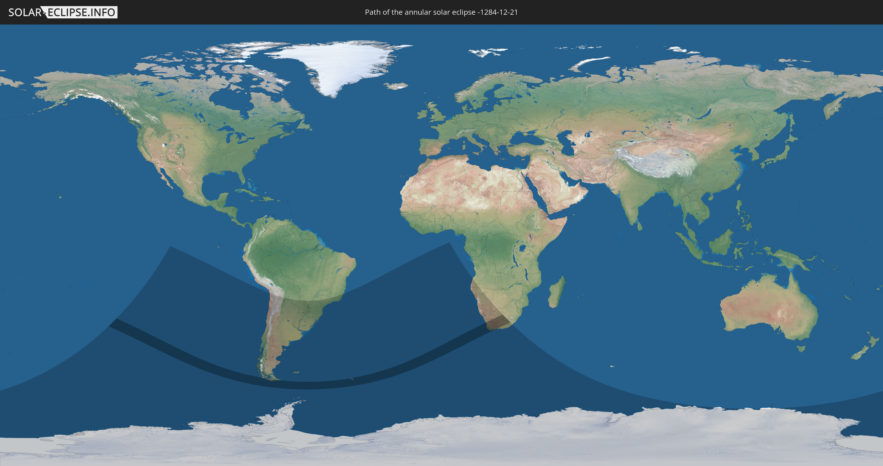
Die Sonnenfinsternis am 12/21/-1284 kann man in 16 Ländern als partielle Sonnenfinsternis beobachten.
Der Finsternispfad verläuft durch 4 Länder. Nur in diesen Ländern ist sie als annular Sonnenfinsternis zu sehen.
In den folgenden Ländern ist die Sonnenfinsternis annular zu sehen
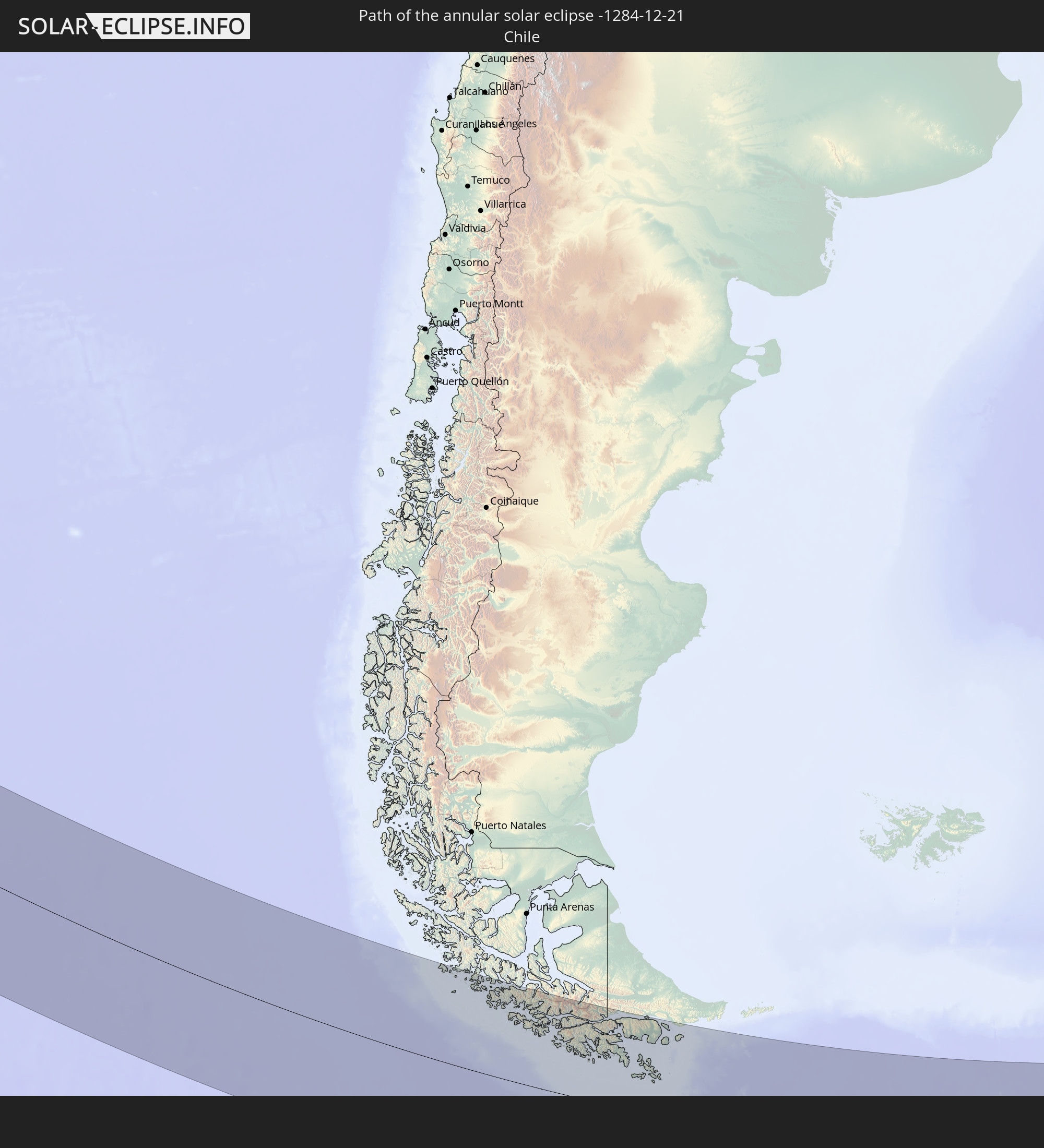 Chile
Chile
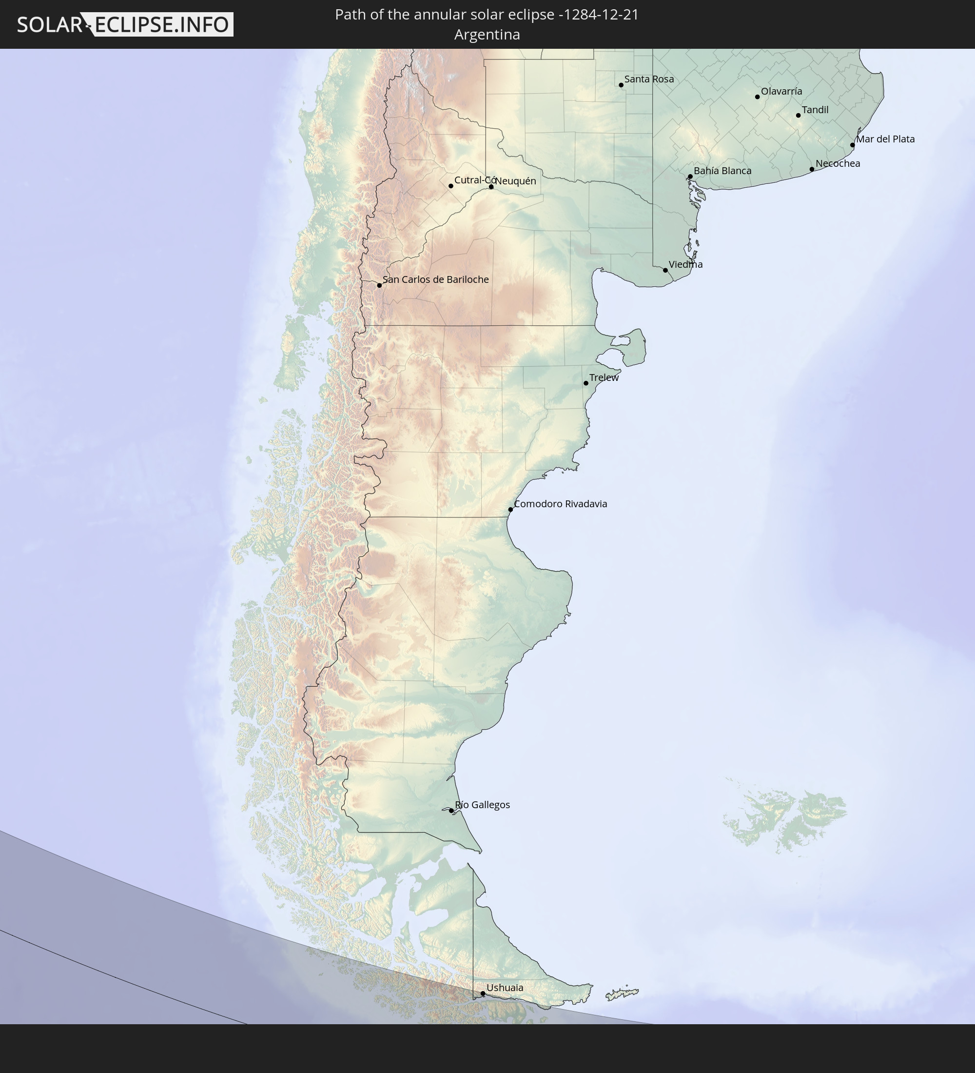 Argentina
 South Georgia and the South Sandwich Islands
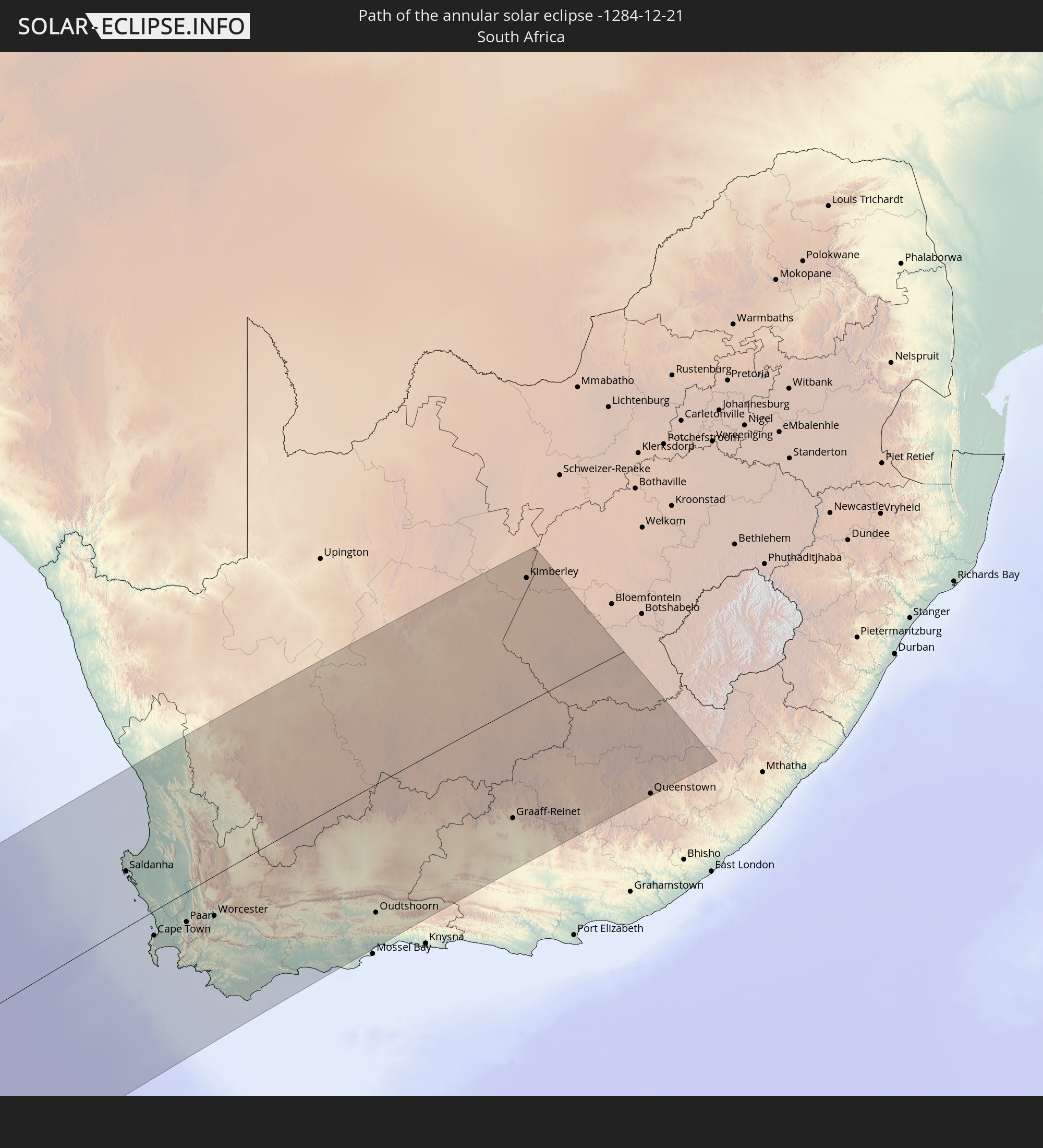 South Africa
In den folgenden Ländern ist die Sonnenfinsternis partiell zu sehen


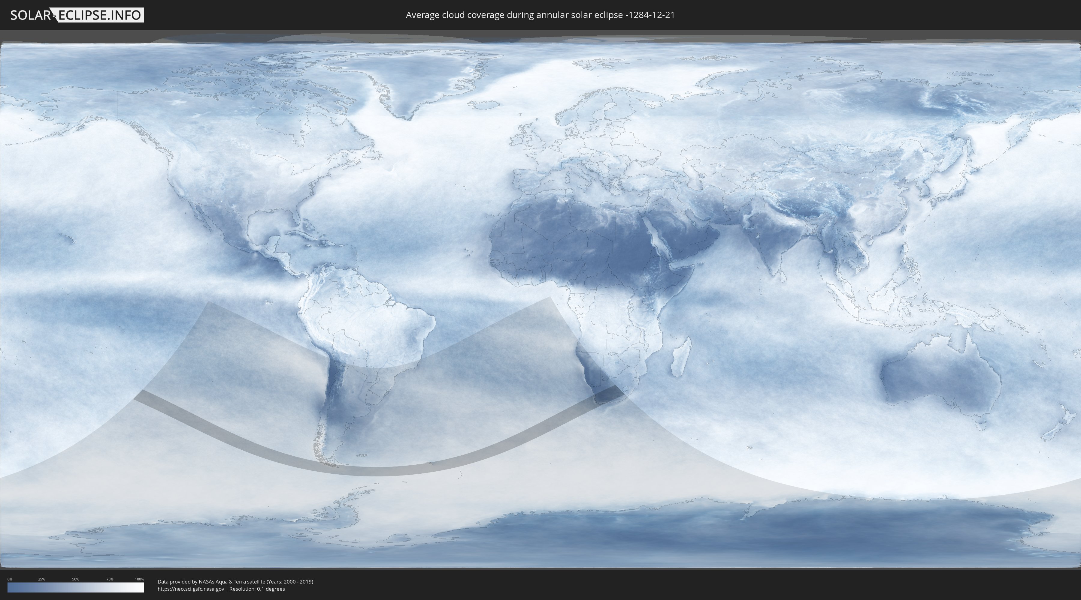
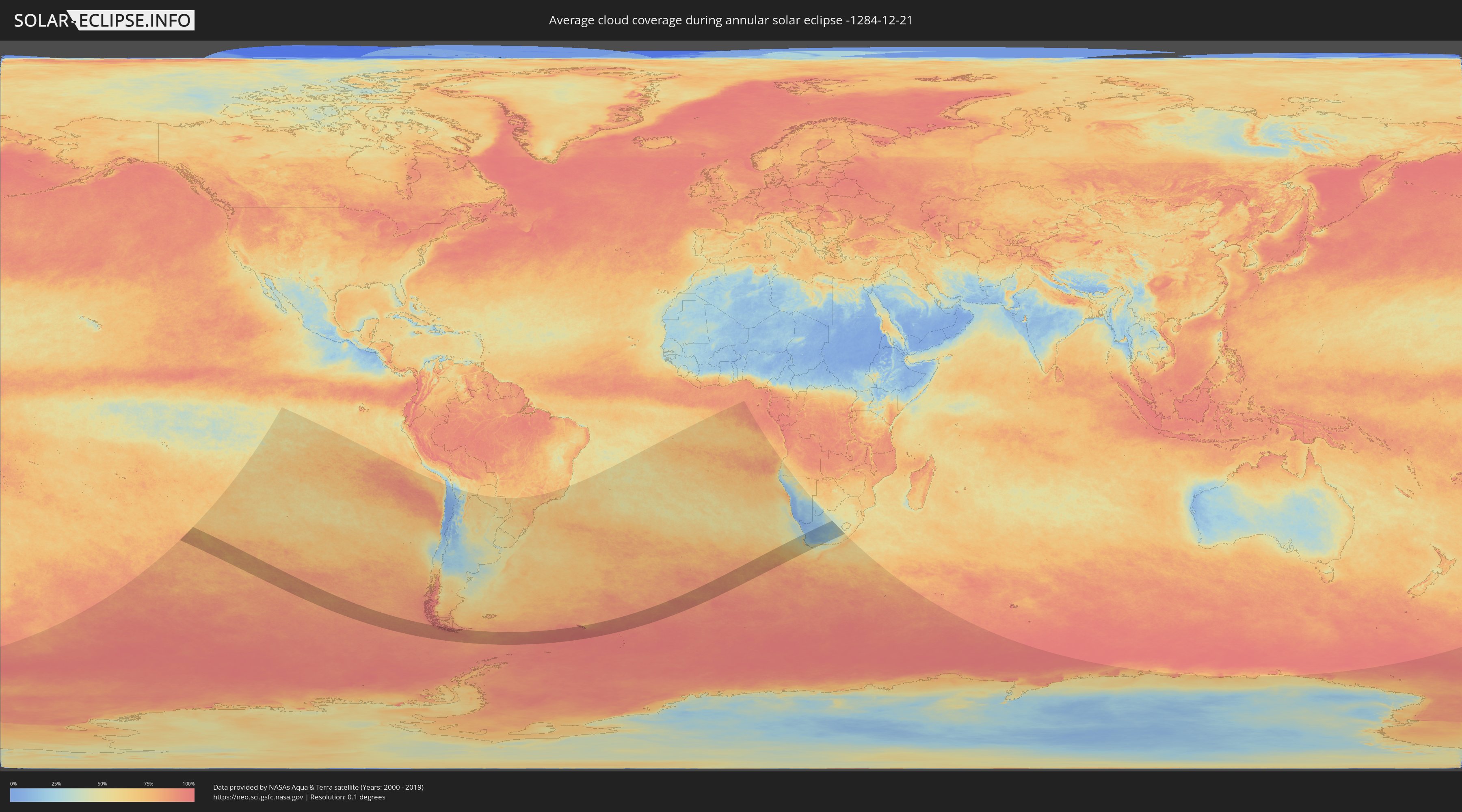
How will be the weather during the annular solar eclipse on 12/21/-1284?
Where is the best place to see the annular solar eclipse of 12/21/-1284?
The following maps show the average cloud coverage for the day of the annular solar eclipse.
With the help of these maps, it is possible to find the place along the eclipse path, which has the best
chance of a cloudless sky.
Nevertheless, you should consider local circumstances and inform about the weather of your chosen
observation site.
The data is provided by NASAs satellites
AQUA and TERRA.
The cloud maps are averaged over a period of 19 years (2000 - 2019).
Detailed country maps
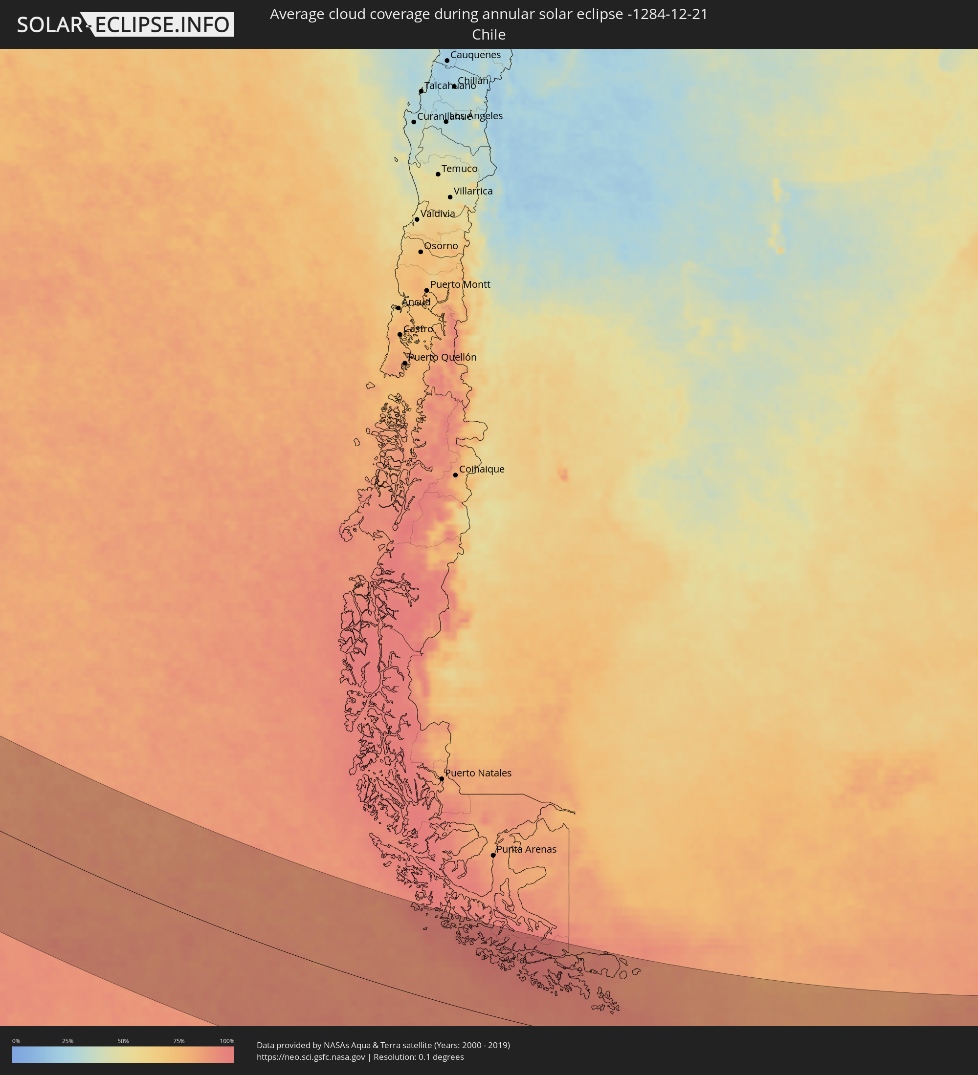 Chile
Chile
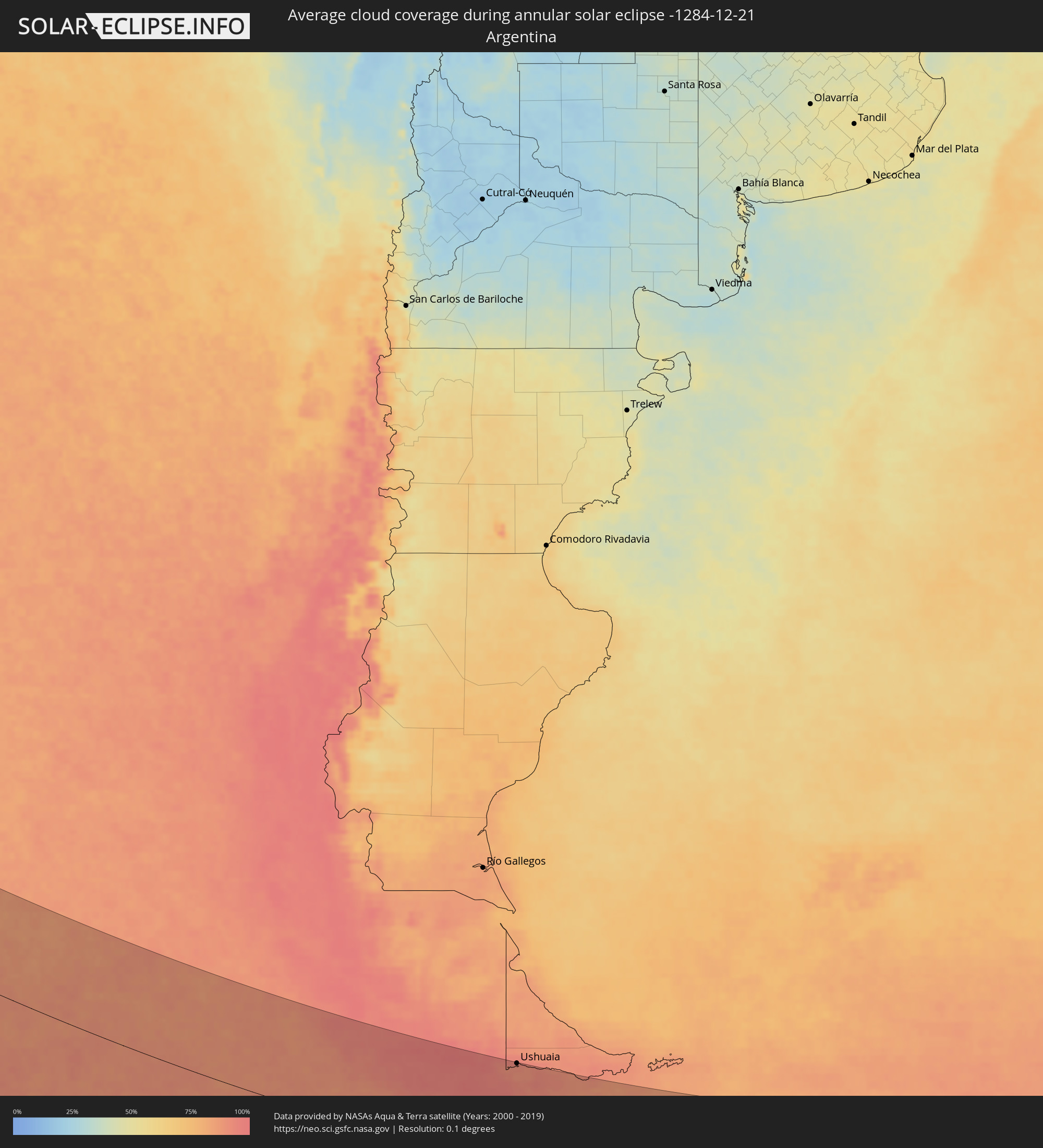 Argentina
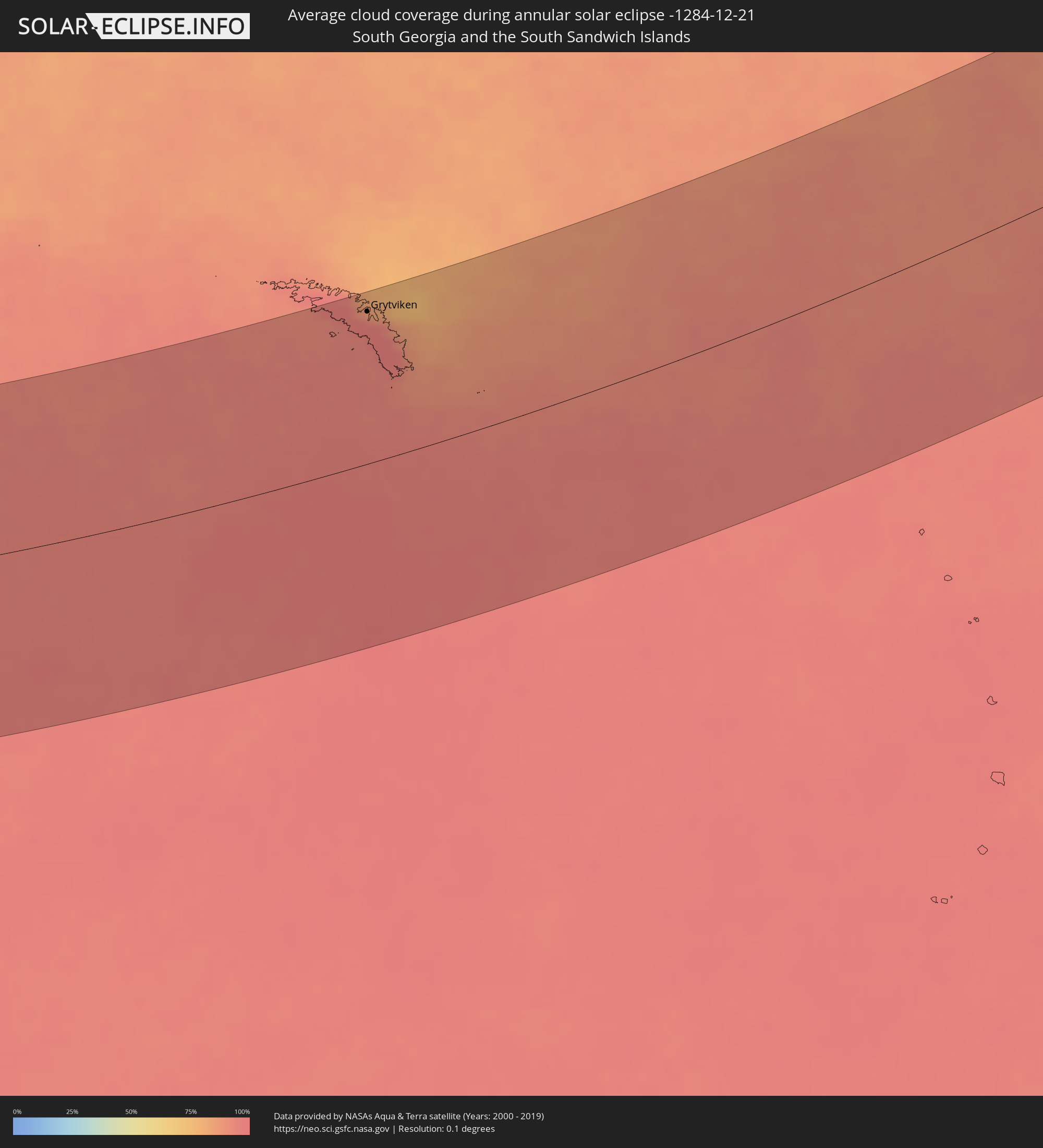 South Georgia and the South Sandwich Islands
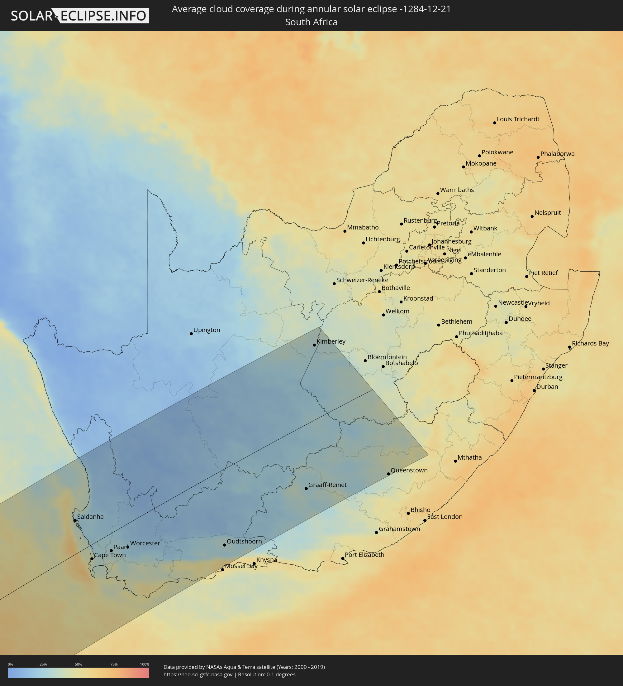 South Africa
Cities inside the path of the eclipse
The following table shows all locations with a population of more than 5,000 inside the eclipse path. Cities which have more than 100,000 inhabitants are marked bold. A click at the locations opens a detailed map.
| City | Type | Eclipse duration | Local time of max. eclipse | Distance to central line | Ø Cloud coverage |
 Ushuaia, Tierra del Fuego Province
|
annular | - | 10:52:03 UTC-04:16 | 169 km | 91% |
 Grytviken
|
annular | - | 14:01:37 UTC-02:00 | 151 km | 92% |
 Saldanha, Western Cape
|
annular | - | 18:42:29 UTC+01:30 | 78 km | 36% |
|
Constantia, Western Cape
|
annular | - | 18:41:02 UTC+01:30 | 48 km | 36% |
|
Cape Town, Western Cape
|
annular | - | 18:41:10 UTC+01:30 | 42 km | 39% |
|
Newlands, Western Cape
|
annular | - | 18:41:06 UTC+01:30 | 47 km | 36% |
|
Claremont, Western Cape
|
annular | - | 18:41:05 UTC+01:30 | 48 km | 35% |
|
Rosebank, Western Cape
|
annular | - | 18:41:07 UTC+01:30 | 47 km | 35% |
|
Retreat, Western Cape
|
annular | - | 18:40:59 UTC+01:30 | 54 km | 37% |
|
Rondebosch, Western Cape
|
annular | - | 18:41:06 UTC+01:30 | 48 km | 35% |
|
Atlantis, Western Cape
|
annular | - | 18:41:37 UTC+01:30 | 4 km | 26% |
|
Lansdowne, Western Cape
|
annular | - | 18:41:04 UTC+01:30 | 50 km | 35% |
|
Vredendal, Western Cape
|
annular | - | 18:44:02 UTC+01:30 | 180 km | 14% |
|
Kraaifontein, Western Cape
|
annular | - | 18:41:11 UTC+01:30 | 40 km | 32% |
|
Malmesbury, Western Cape
|
annular | - | 18:41:41 UTC+01:30 | 23 km | 28% |
|
Stellenbosch, Western Cape
|
annular | - | 18:41:02 UTC+01:30 | 56 km | 38% |
|
Paarl, Western Cape
|
annular | - | 18:41:16 UTC+01:30 | 49 km | 32% |
|
Grabouw, Western Cape
|
annular | - | 18:40:43 UTC+01:30 | 83 km | 42% |
|
Hermanus, Western Cape
|
annular | - | 18:40:18 UTC+01:30 | 119 km | 45% |
|
Ceres, Western Cape
|
annular | - | 18:41:38 UTC+01:30 | 30 km | 21% |
|
Worcester, Western Cape
|
annular | - | 18:41:14 UTC+01:30 | 57 km | 23% |
|
Calvinia, Northern Cape
|
annular | - | 18:43:52 UTC+01:30 | 140 km | 11% |
|
Bredasdorp, Western Cape
|
annular | - | 18:39:55 UTC+01:30 | 168 km | 53% |
|
Swellendam, Western Cape
|
annular | - | 18:40:27 UTC+01:30 | 139 km | 41% |
|
Hardys Memories of Africa, Western Cape
|
annular | - | 18:40:31 UTC+01:30 | 139 km | 38% |
|
Riversdale, Western Cape
|
annular | - | 18:40:06 UTC+01:30 | 184 km | 48% |
|
Ladismith, Western Cape
|
annular | - | 18:40:51 UTC+01:30 | 125 km | 25% |
|
Albertina, Western Cape
|
annular | - | 18:39:51 UTC+01:30 | 208 km | 49% |
|
Prince Albert, Western Cape
|
annular | - | 18:40:55 UTC+01:30 | 135 km | 18% |
|
Carnarvon, Northern Cape
|
annular | - | 18:43:36 UTC+01:30 | 81 km | 17% |
|
Oudtshoorn, Western Cape
|
annular | - | 18:40:24 UTC+01:30 | 180 km | 28% |
|
Beaufort West, Western Cape
|
annular | - | 18:41:47 UTC+01:30 | 78 km | 17% |
|
Prieska, Northern Cape
|
annular | - | 18:44:52 UTC+01:30 | 181 km | 17% |
|
Willowmore, Eastern Cape
|
annular | - | 18:40:17 UTC+01:30 | 208 km | 25% |
|
De Aar, Northern Cape
|
annular | - | 18:43:12 UTC+01:30 | 30 km | 21% |
|
Barkly West, Northern Cape
|
annular | - | 18:45:19 UTC+01:30 | 212 km | 32% |
|
Graaff-Reinet, Eastern Cape
|
annular | - | 18:41:07 UTC+01:30 | 156 km | 29% |
|
Ritchie, Northern Cape
|
annular | - | 18:44:44 UTC+01:30 | 159 km | 27% |
|
Kimberley, Northern Cape
|
annular | - | 18:45:00 UTC+01:30 | 182 km | 29% |
|
Middelburg, Eastern Cape
|
annular | - | 18:41:48 UTC+01:30 | 101 km | 28% |
|
Colesberg, Northern Cape
|
annular | - | 18:42:38 UTC+01:30 | 29 km | 27% |
|
Cradock, Eastern Cape
|
annular | - | 18:40:45 UTC+01:30 | 195 km | 33% |
|
Burgersdorp, Eastern Cape
|
annular | - | 18:41:45 UTC+01:30 | 114 km | 31% |
|
Molteno, Eastern Cape
|
annular | - | 18:41:17 UTC+01:30 | 153 km | 36% |
|
Aliwal North, Eastern Cape
|
annular | - | 18:41:55 UTC+01:30 | 99 km | 35% |
|
Queenstown, Eastern Cape
|
annular | - | 18:40:29 UTC+01:30 | 226 km | 39% |
|
Queensdale, Eastern Cape
|
annular | - | 18:40:28 UTC+01:30 | 227 km | 39% |
|
Dordrecht, Eastern Cape
|
annular | - | 18:41:00 UTC+01:30 | 182 km | 43% |
|
Lady Frere, Eastern Cape
|
annular | - | 18:40:32 UTC+01:30 | 222 km | 44% |
|
Elliot, Eastern Cape
|
annular | - | 18:40:39 UTC+01:30 | 217 km | 48% |