Annular solar eclipse of 12/18/-1414
| Day of week: | Saturday |
| Maximum duration of eclipse: | 02m42s |
| Maximum width of eclipse path: | 119 km |
| Saros cycle: | 19 |
| Coverage: | 97.1% |
| Magnitude: | 0.9705 |
| Gamma: | -0.449 |
Wo kann man die Sonnenfinsternis vom 12/18/-1414 sehen?
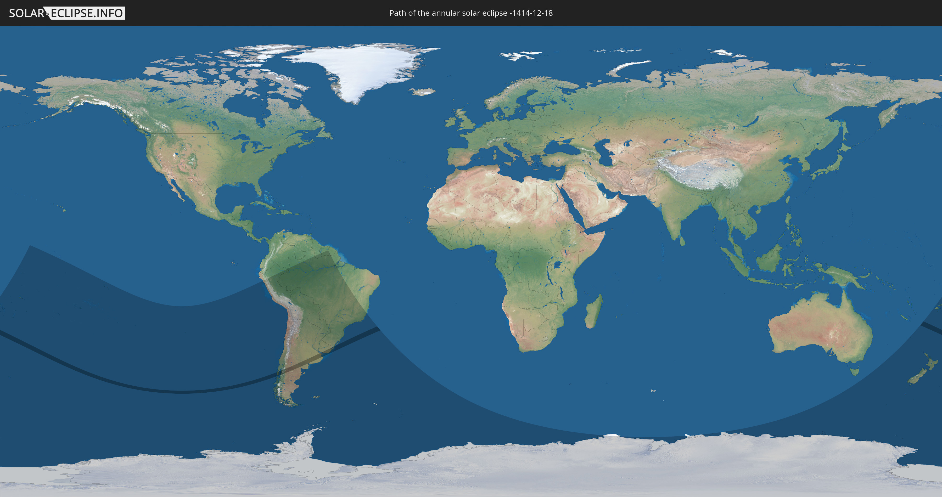
Die Sonnenfinsternis am 12/18/-1414 kann man in 29 Ländern als partielle Sonnenfinsternis beobachten.
Der Finsternispfad verläuft durch 4 Länder. Nur in diesen Ländern ist sie als annular Sonnenfinsternis zu sehen.
In den folgenden Ländern ist die Sonnenfinsternis annular zu sehen
 Chile
Chile
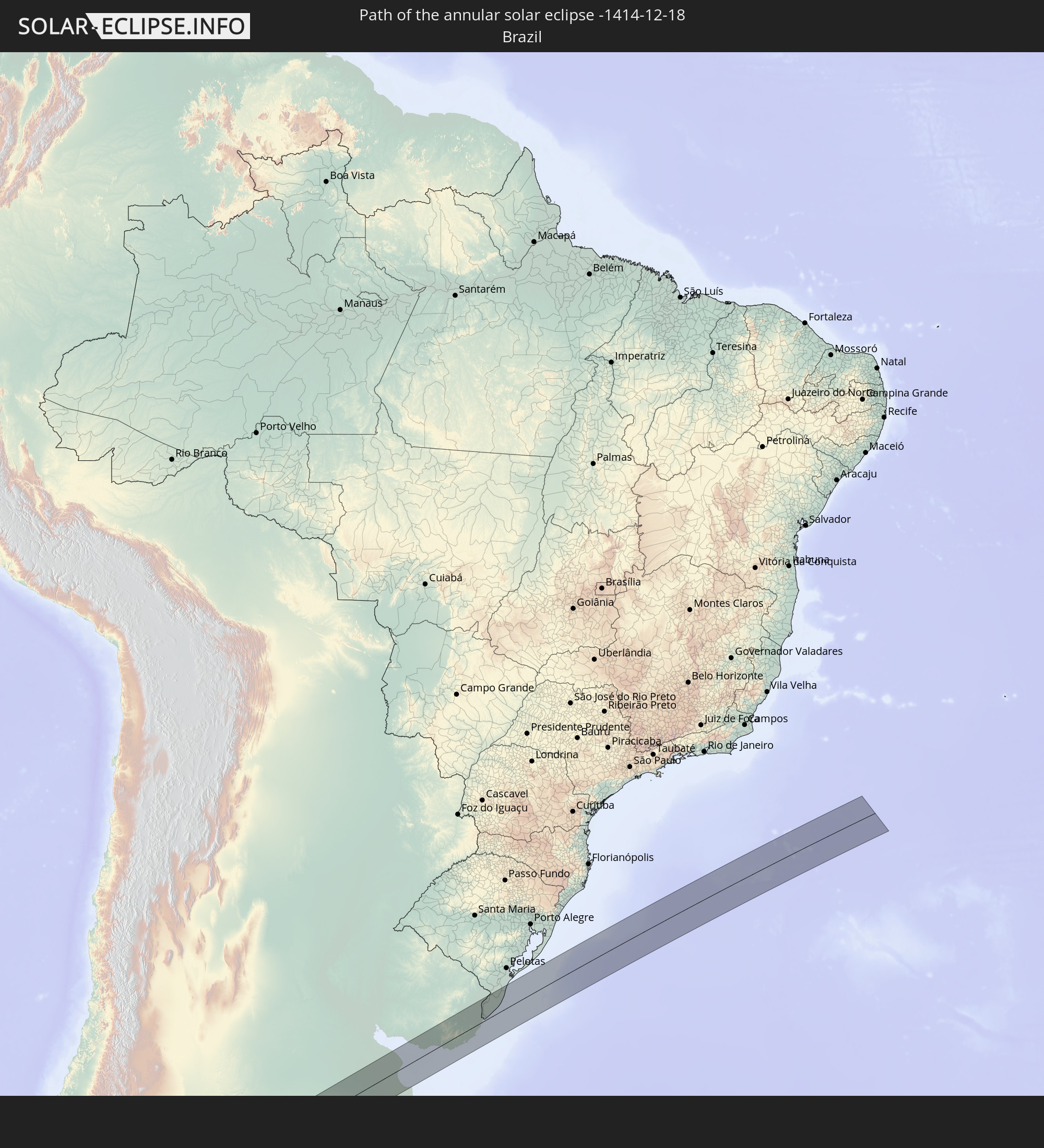 Brazil
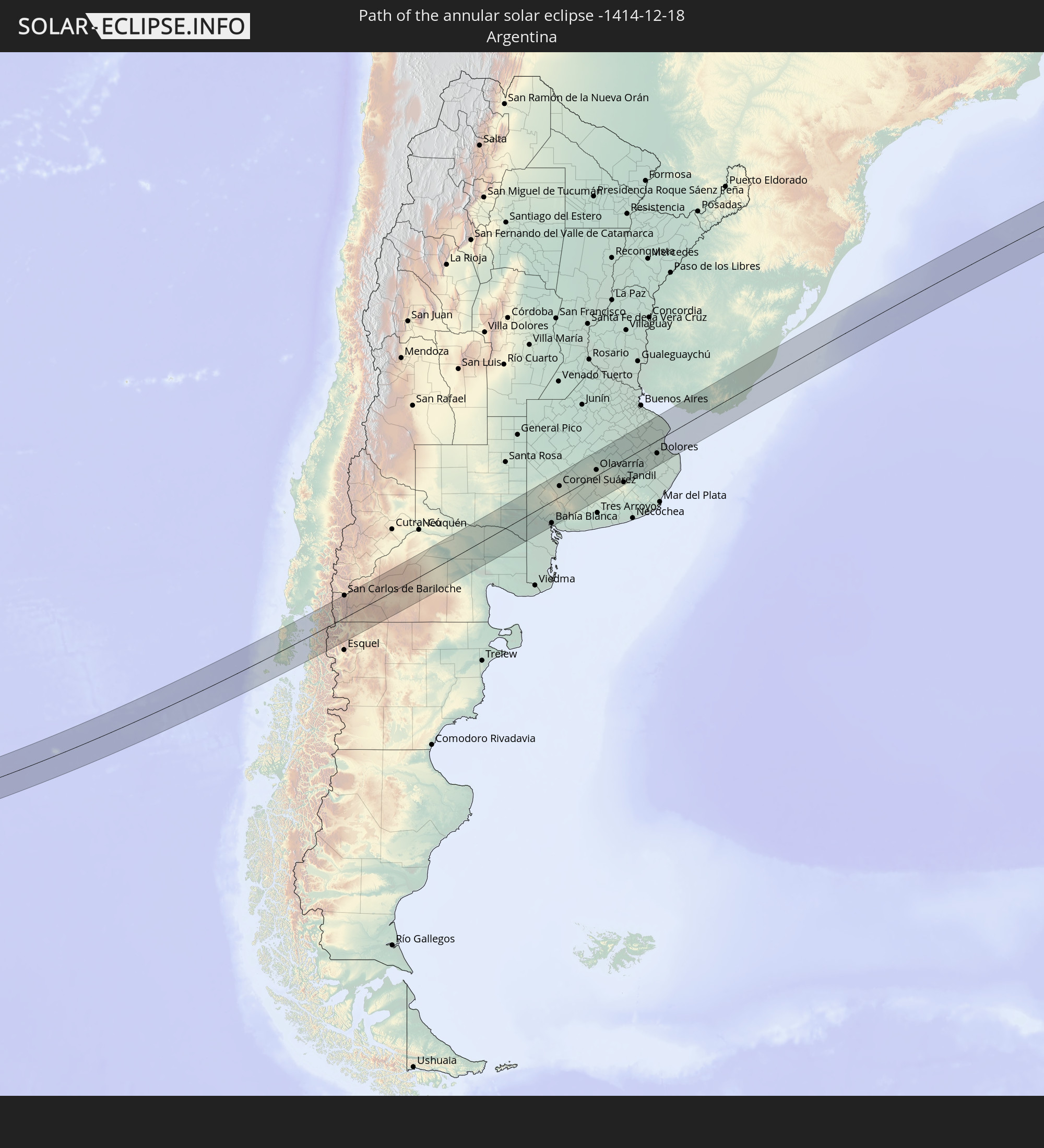 Argentina
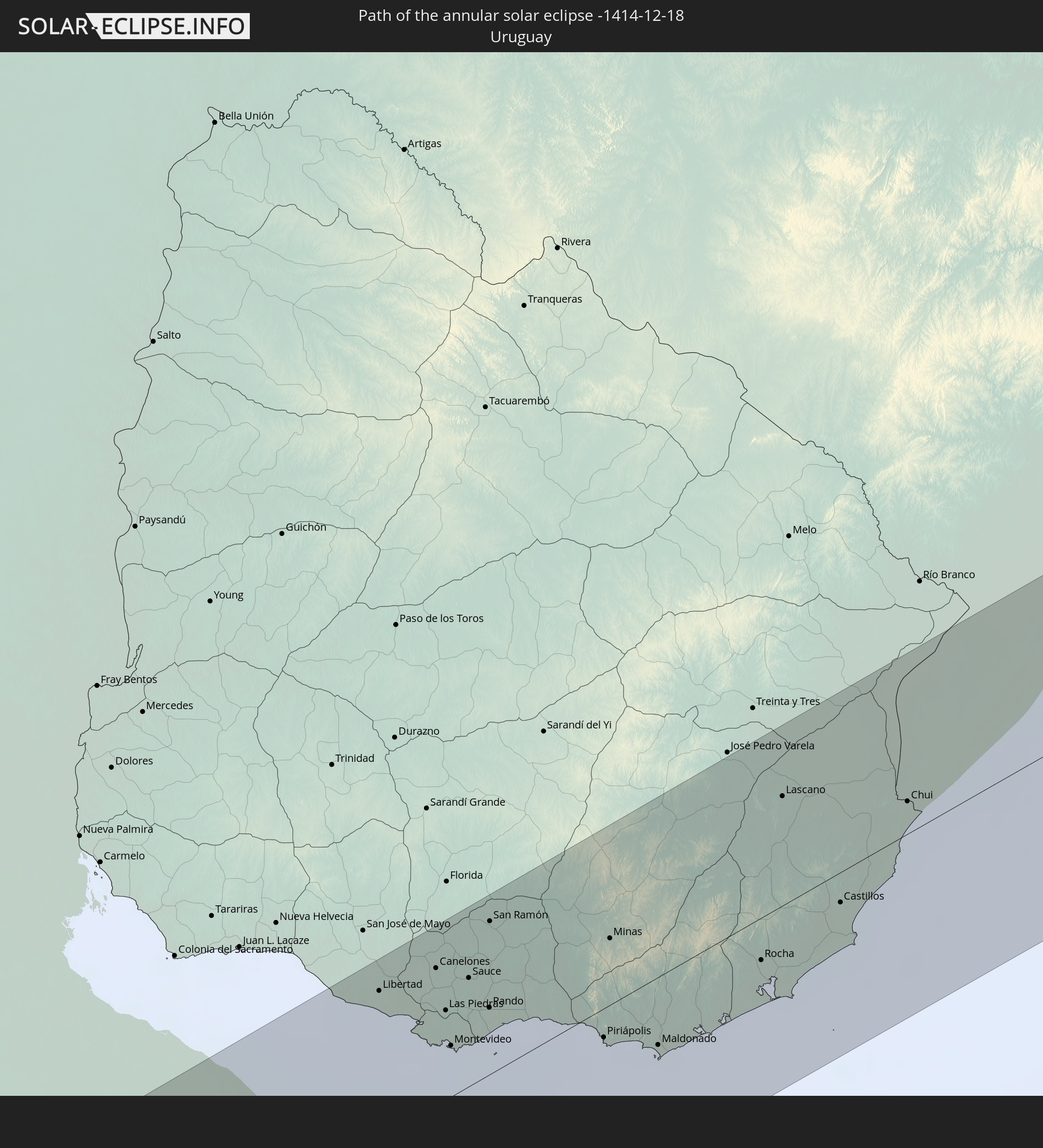 Uruguay
In den folgenden Ländern ist die Sonnenfinsternis partiell zu sehen
 Fiji
Fiji
 Antarctica
 New Zealand
 United States Minor Outlying Islands
 Wallis and Futuna
 Tonga
Tonga
 Kiribati
 Samoa
Samoa
 Tokelau
 American Samoa
 Niue
Niue
 Cook Islands
 French Polynesia
 Pitcairn Islands
 Chile
Chile
 Colombia
 Peru
Peru
 Brazil
 Argentina
 Bolivia
 Paraguay
 Falkland Islands
 Guyana
 Uruguay
 Suriname
 French Guiana
 South Georgia and the South Sandwich Islands
 Australia
 Norfolk Island
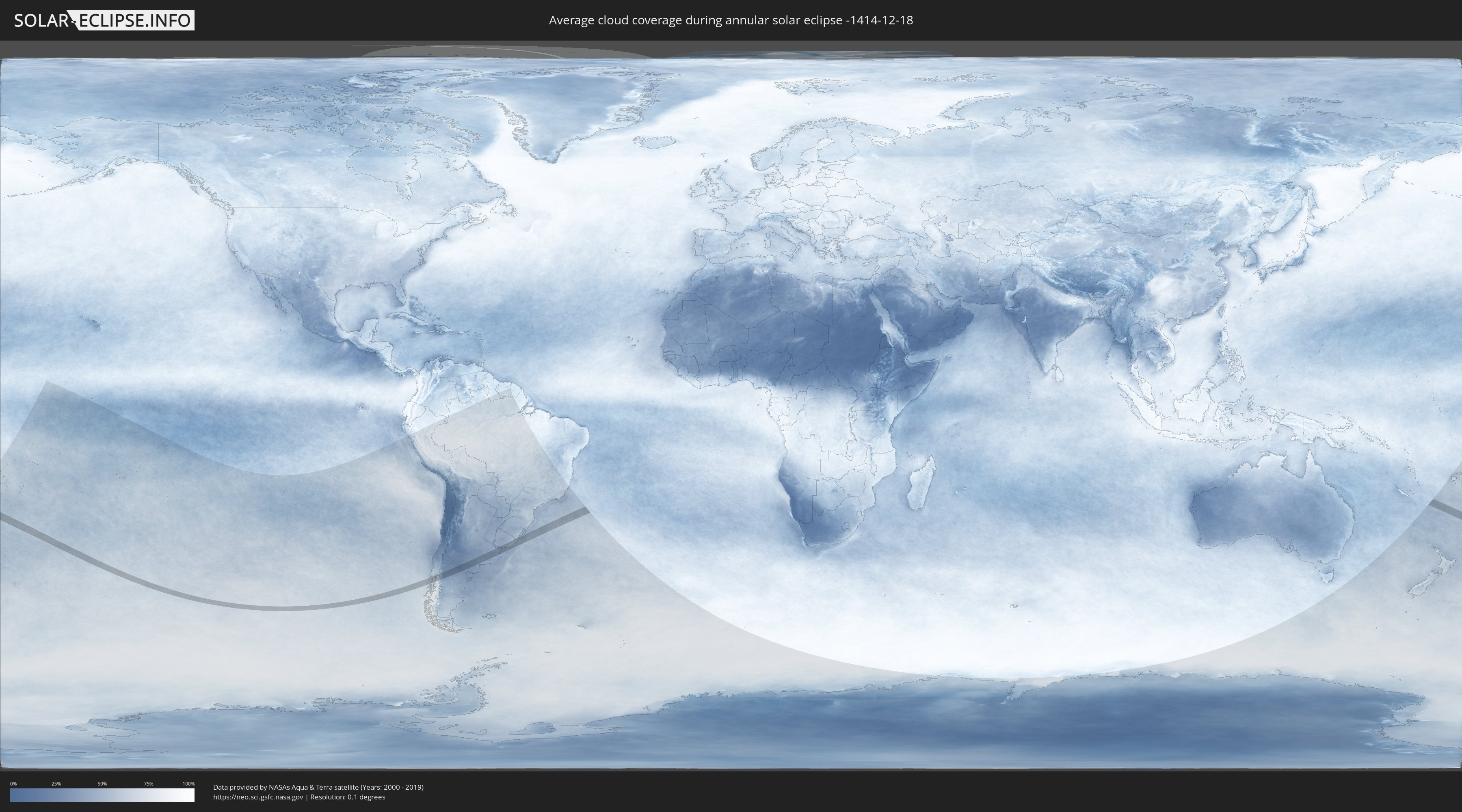
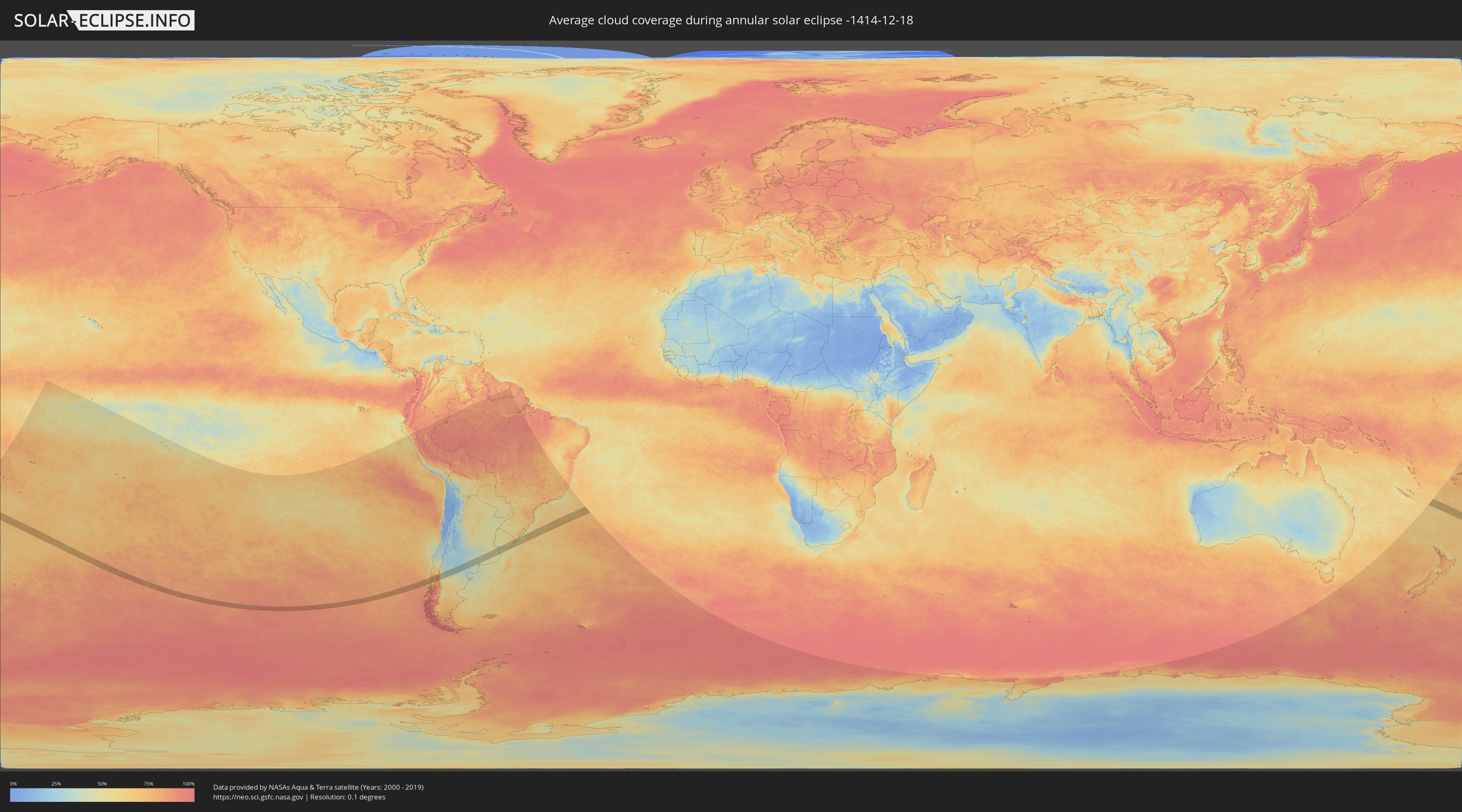
How will be the weather during the annular solar eclipse on 12/18/-1414?
Where is the best place to see the annular solar eclipse of 12/18/-1414?
The following maps show the average cloud coverage for the day of the annular solar eclipse.
With the help of these maps, it is possible to find the place along the eclipse path, which has the best
chance of a cloudless sky.
Nevertheless, you should consider local circumstances and inform about the weather of your chosen
observation site.
The data is provided by NASAs satellites
AQUA and TERRA.
The cloud maps are averaged over a period of 19 years (2000 - 2019).
Detailed country maps
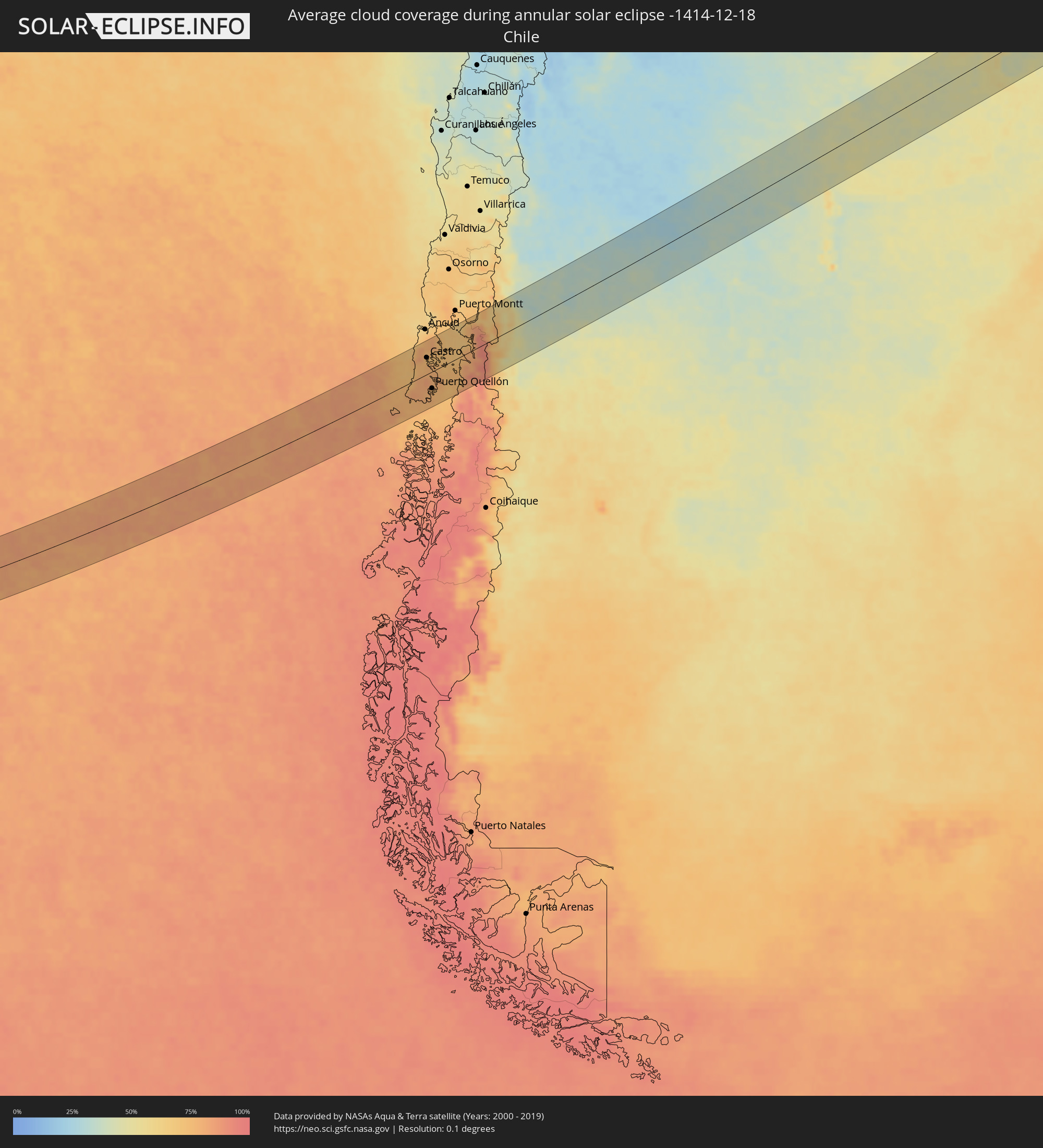 Chile
Chile
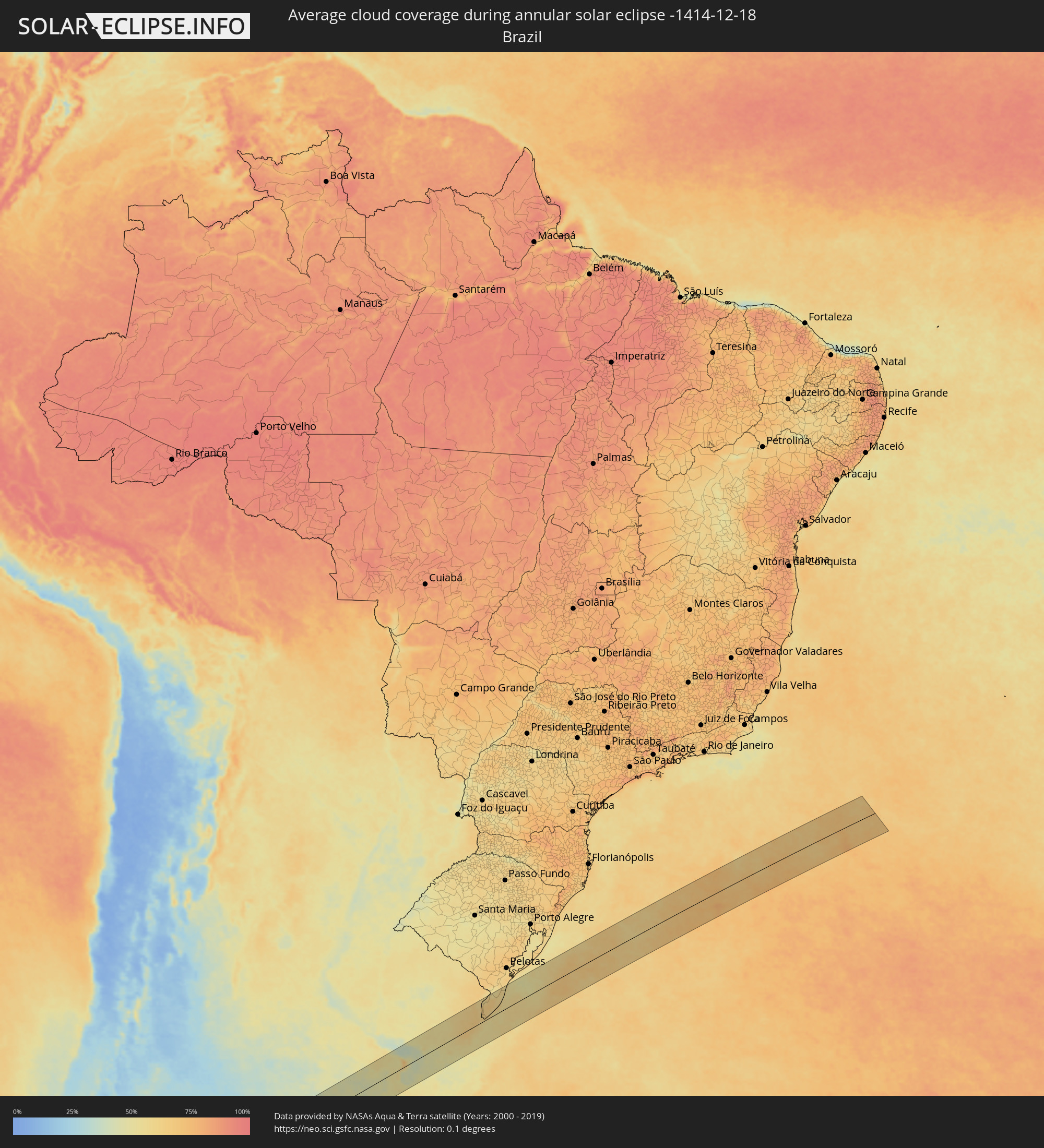 Brazil
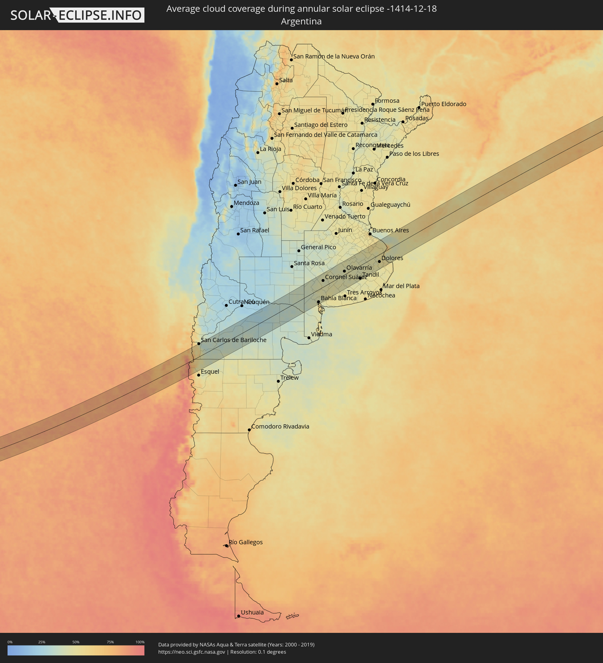 Argentina
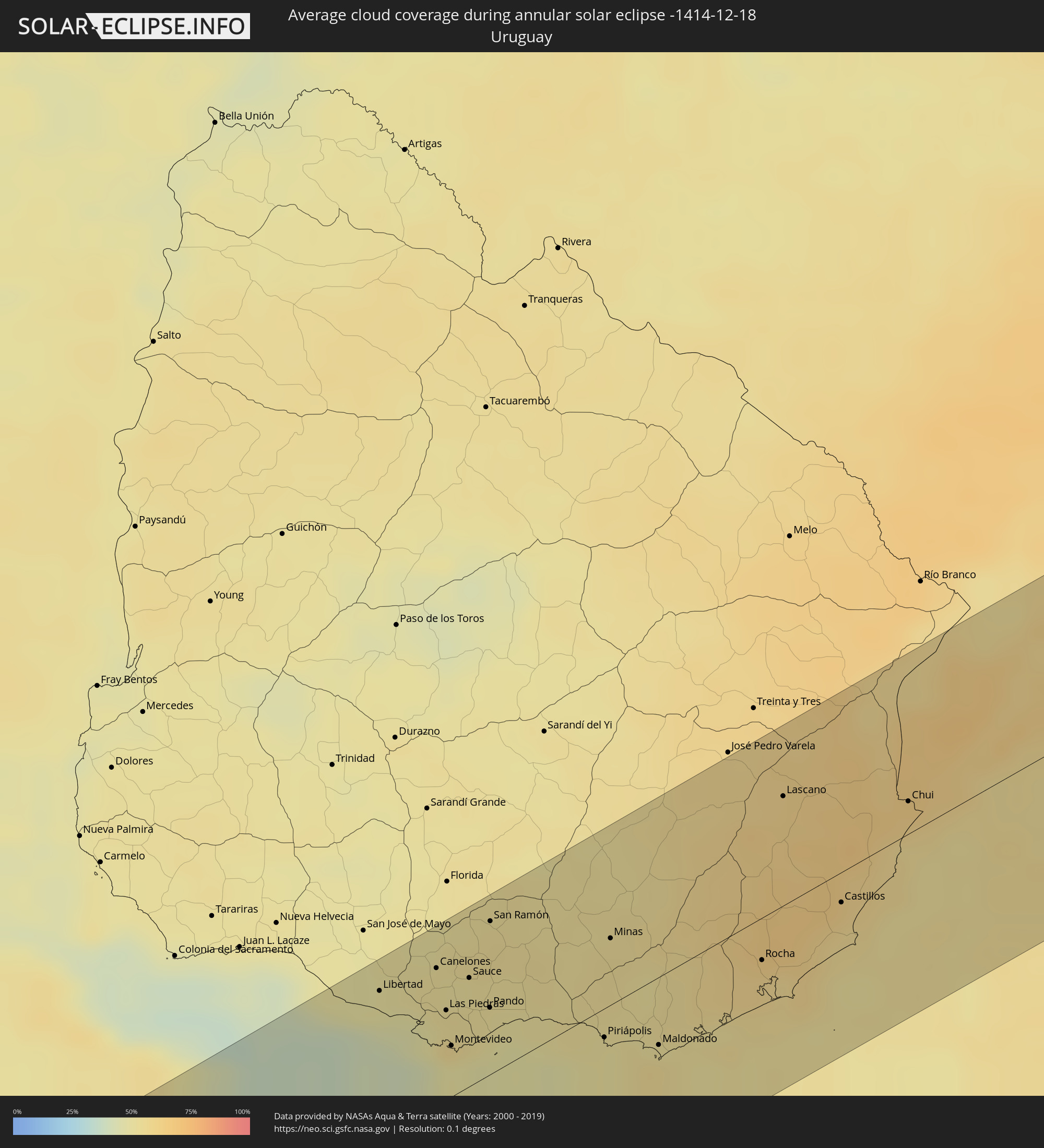 Uruguay
Cities inside the path of the eclipse
The following table shows all locations with a population of more than 5,000 inside the eclipse path. Cities which have more than 100,000 inhabitants are marked bold. A click at the locations opens a detailed map.
| City | Type | Eclipse duration | Local time of max. eclipse | Distance to central line | Ø Cloud coverage |
|
Chonchi, Los Lagos
|
annular | - | 15:53:48 UTC-04:42 | 20 km | 77% |
|
Castro, Los Lagos
|
annular | - | 15:54:02 UTC-04:42 | 35 km | 74% |
|
Puerto Quellón, Los Lagos
|
annular | - | 15:53:09 UTC-04:42 | 35 km | 74% |
|
El Bolsón, Río Negro Province
|
annular | - | 16:22:49 UTC-04:16 | 1 km | 57% |
|
San Carlos de Bariloche, Río Negro Province
|
annular | - | 16:24:18 UTC-04:16 | 71 km | 40% |
|
Ingeniero Jacobacci, Río Negro Province
|
annular | - | 16:25:26 UTC-04:16 | 17 km | 33% |
|
Fray Luis Beltrán, Río Negro Province
|
annular | - | 16:31:13 UTC-04:16 | 22 km | 32% |
|
Lamarque, Río Negro Province
|
annular | - | 16:31:06 UTC-04:16 | 9 km | 33% |
|
Choele Choel, Río Negro Province
|
annular | - | 16:31:21 UTC-04:16 | 23 km | 32% |
|
Bahía Blanca, Buenos Aires
|
annular | - | 16:34:04 UTC-04:16 | 71 km | 49% |
|
Coronel Suárez, Buenos Aires
|
annular | - | 16:36:09 UTC-04:16 | 36 km | 43% |
|
Olavarría, Buenos Aires
|
annular | - | 16:37:41 UTC-04:16 | 19 km | 46% |
|
Azul, Buenos Aires
|
annular | - | 16:38:02 UTC-04:16 | 9 km | 46% |
|
Tandil, Buenos Aires
|
annular | - | 16:37:30 UTC-04:16 | 76 km | 44% |
|
Dolores, Buenos Aires
|
annular | - | 16:39:27 UTC-04:16 | 44 km | 50% |
|
Libertad, San José
|
annular | - | 17:14:06 UTC-03:44 | 70 km | 49% |
|
Santa Lucía, Canelones
|
annular | - | 17:14:24 UTC-03:44 | 77 km | 51% |
|
Delta del Tigre, San José
|
annular | - | 17:13:59 UTC-03:44 | 45 km | 46% |
|
Canelones, Canelones
|
annular | - | 17:14:20 UTC-03:44 | 65 km | 52% |
|
La Paz, Canelones
|
annular | - | 17:14:01 UTC-03:44 | 40 km | 56% |
|
Las Piedras, Canelones
|
annular | - | 17:14:04 UTC-03:44 | 42 km | 52% |
|
Progreso, Canelones
|
annular | - | 17:14:09 UTC-03:44 | 48 km | 52% |
|
Montevideo, Montevideo
|
annular | - | 17:13:49 UTC-03:44 | 24 km | 49% |
|
Sauce, Canelones
|
annular | - | 17:14:19 UTC-03:44 | 51 km | 53% |
|
Paso de Carrasco, Canelones
|
annular | - | 17:13:55 UTC-03:44 | 22 km | 49% |
|
Joaquín Suárez, Canelones
|
annular | - | 17:14:06 UTC-03:44 | 33 km | 52% |
|
Colonia Nicolich, Canelones
|
annular | - | 17:13:59 UTC-03:44 | 25 km | 51% |
|
Pando, Canelones
|
annular | - | 17:14:08 UTC-03:44 | 32 km | 52% |
|
San Ramón, Canelones
|
annular | - | 17:14:44 UTC-03:44 | 73 km | 54% |
|
Piriápolis, Maldonado
|
annular | - | 17:14:05 UTC-03:44 | 14 km | 51% |
|
Minas, Lavalleja
|
annular | - | 17:14:46 UTC-03:44 | 32 km | 55% |
|
Pan de Azúcar, Maldonado
|
annular | - | 17:14:13 UTC-03:44 | 7 km | 51% |
|
Maldonado, Maldonado
|
annular | - | 17:14:06 UTC-03:44 | 32 km | 56% |
|
Punta del Este, Maldonado
|
annular | - | 17:14:02 UTC-03:44 | 37 km | 55% |
|
San Carlos, Maldonado
|
annular | - | 17:14:16 UTC-03:44 | 23 km | 52% |
|
Rocha, Rocha
|
annular | - | 17:14:48 UTC-03:44 | 20 km | 58% |
|
Lascano, Rocha
|
annular | - | 17:15:56 UTC-03:44 | 52 km | 61% |
|
Castillos, Rocha
|
annular | - | 17:15:16 UTC-03:44 | 14 km | 59% |
|
Chui, Rocha
|
annular | - | 17:16:00 UTC-03:44 | 16 km | 61% |
|
Chuí, Rio Grande do Sul
|
annular | - | 17:16:01 UTC-03:44 | 16 km | 61% |
|
Santa Vitória do Palmar, Rio Grande do Sul
|
annular | - | 17:54:39 UTC-03:06 | 29 km | 64% |