Total solar eclipse of 06/23/-1441
| Day of week: | Thursday |
| Maximum duration of eclipse: | 04m32s |
| Maximum width of eclipse path: | 223 km |
| Saros cycle: | 33 |
| Coverage: | 100% |
| Magnitude: | 1.0606 |
| Gamma: | 0.4478 |
Wo kann man die Sonnenfinsternis vom 06/23/-1441 sehen?

Die Sonnenfinsternis am 06/23/-1441 kann man in 43 Ländern als partielle Sonnenfinsternis beobachten.
Der Finsternispfad verläuft durch 2 Länder. Nur in diesen Ländern ist sie als total Sonnenfinsternis zu sehen.
In den folgenden Ländern ist die Sonnenfinsternis total zu sehen
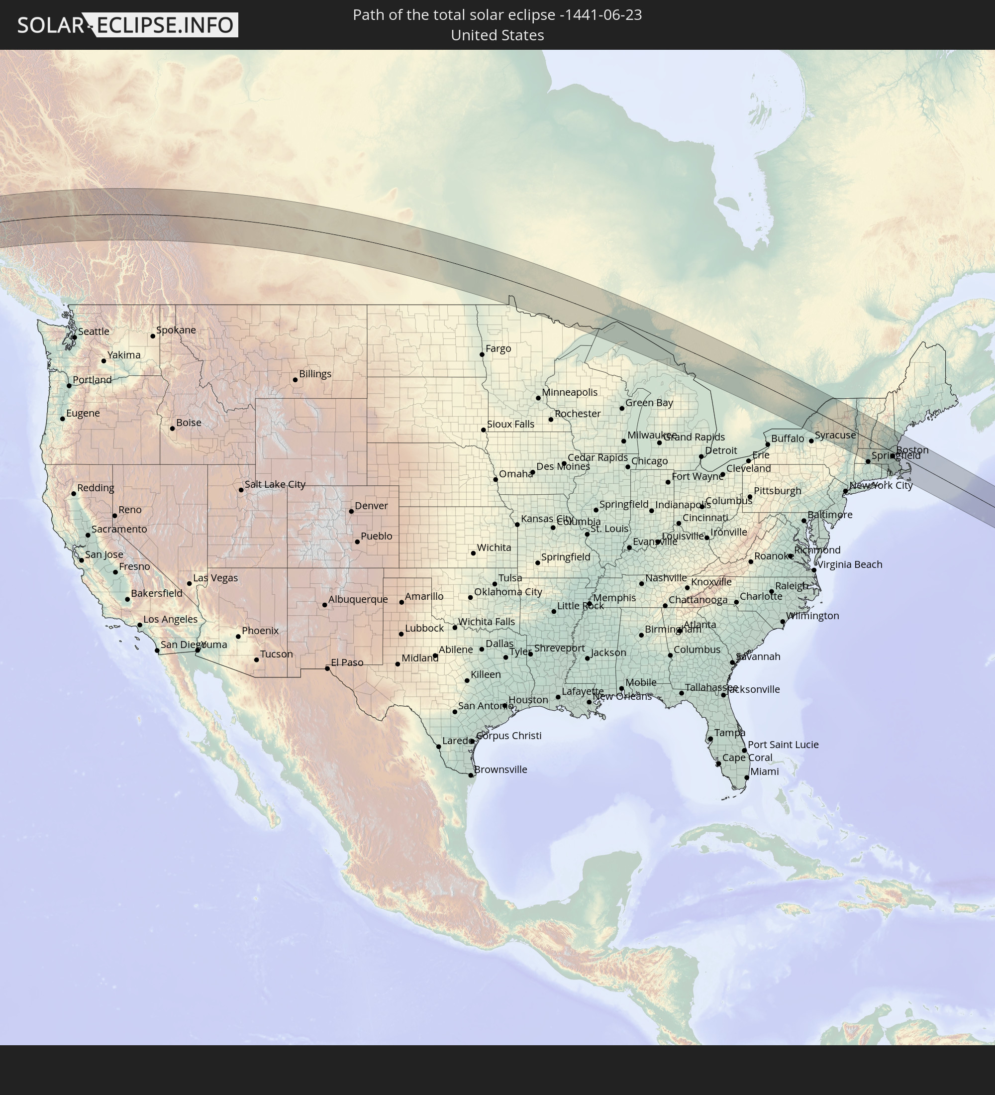 United States
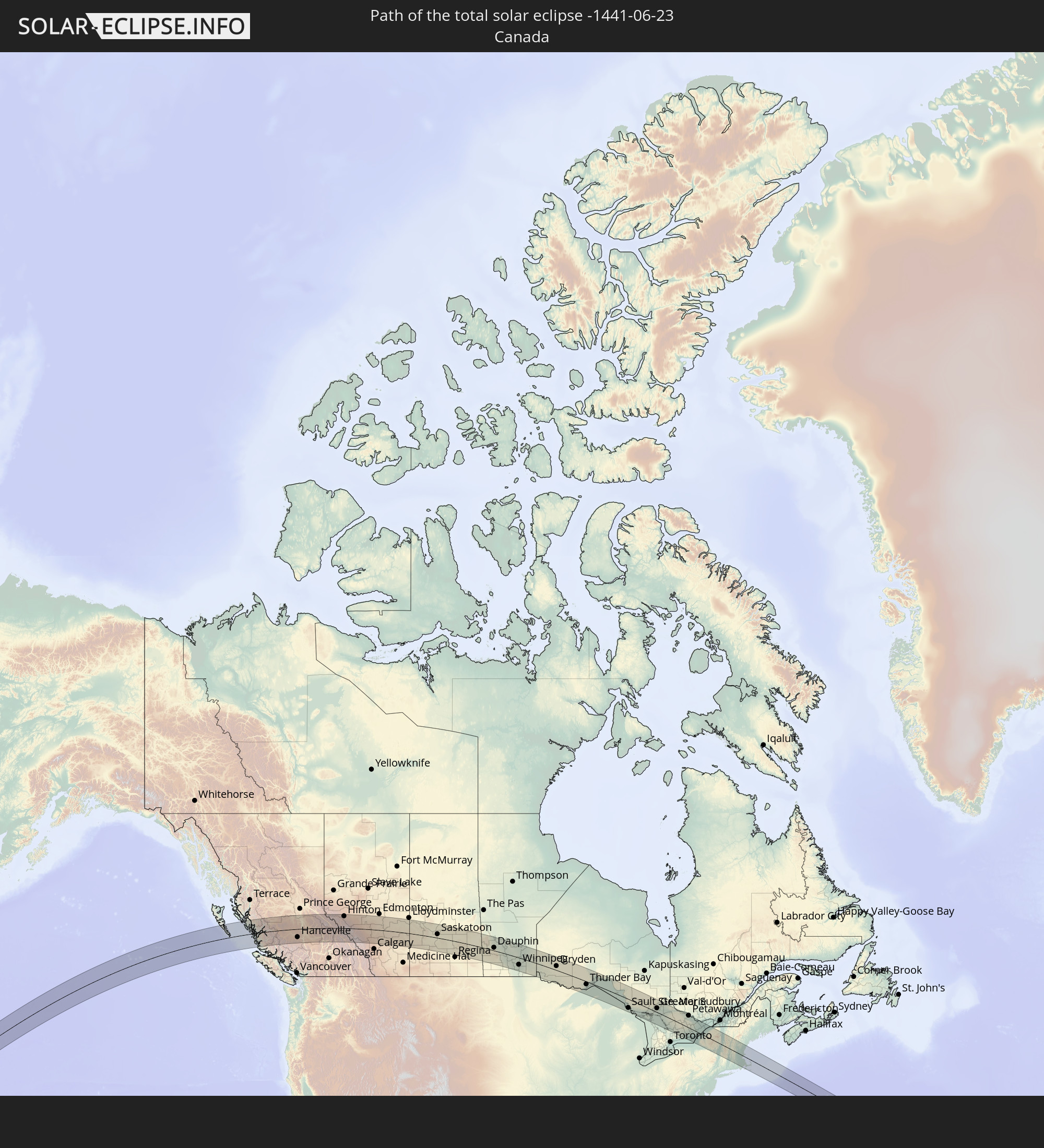 Canada
In den folgenden Ländern ist die Sonnenfinsternis partiell zu sehen
 Russia
 United States
 United States Minor Outlying Islands
 Kiribati
 Canada
 Mexico
 Greenland
 Guatemala
 El Salvador
 Honduras
 Belize
 Nicaragua
 Cuba
Cuba
 Panama
 Colombia
 Cayman Islands
 The Bahamas
 Jamaica
 Haiti
Haiti
 Venezuela
 Turks and Caicos Islands
 Dominican Republic
 Aruba
Aruba
 Puerto Rico
 Bermuda
 Saint Pierre and Miquelon
 Iceland
 Svalbard and Jan Mayen
 Faroe Islands
 Norway
 Sweden
 Finland
 China
China
 Mongolia
 Japan
Japan
 North Korea
 South Korea
 Federated States of Micronesia
 Solomon Islands
 Marshall Islands
 Vanuatu
 Nauru
Nauru
 Tuvalu
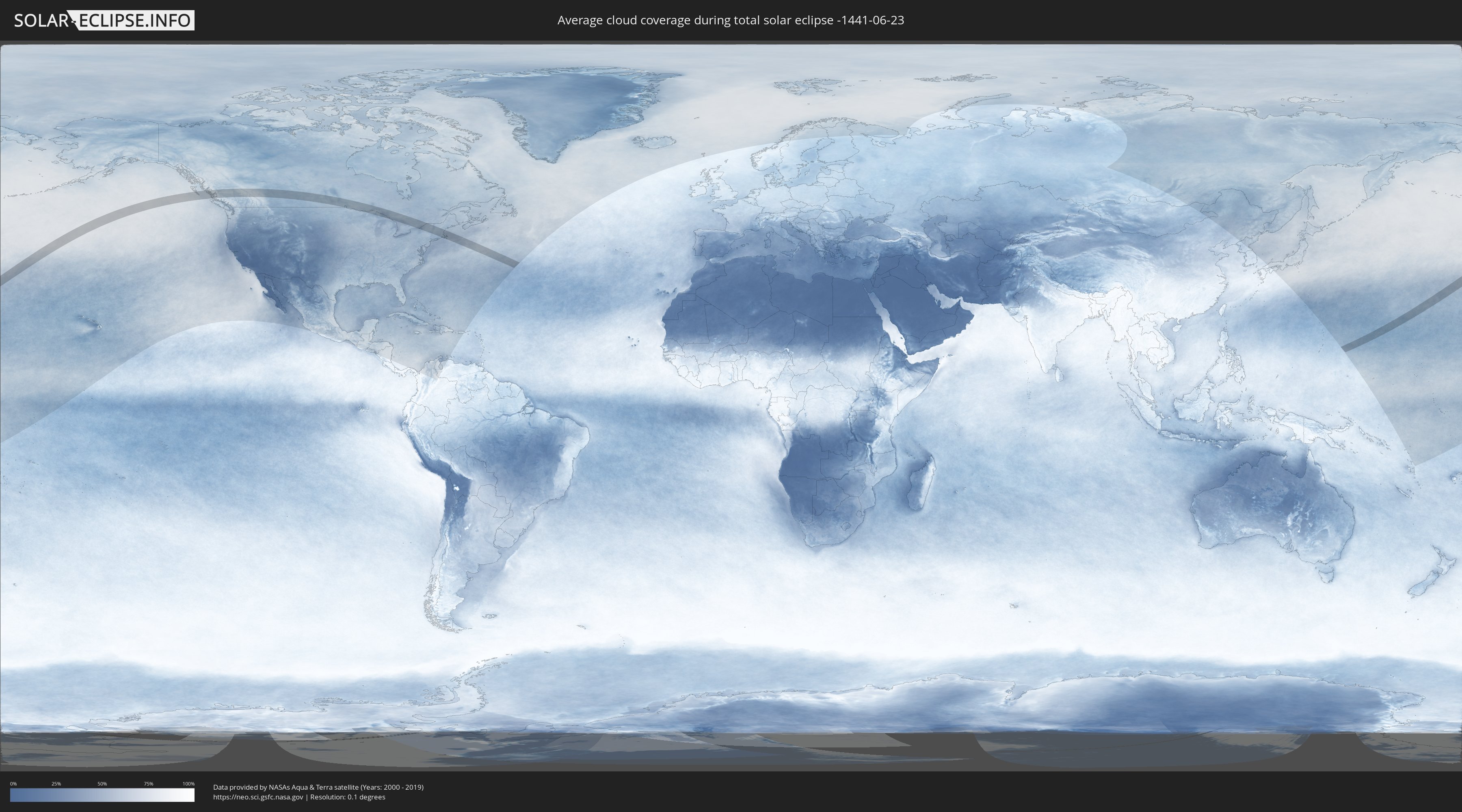
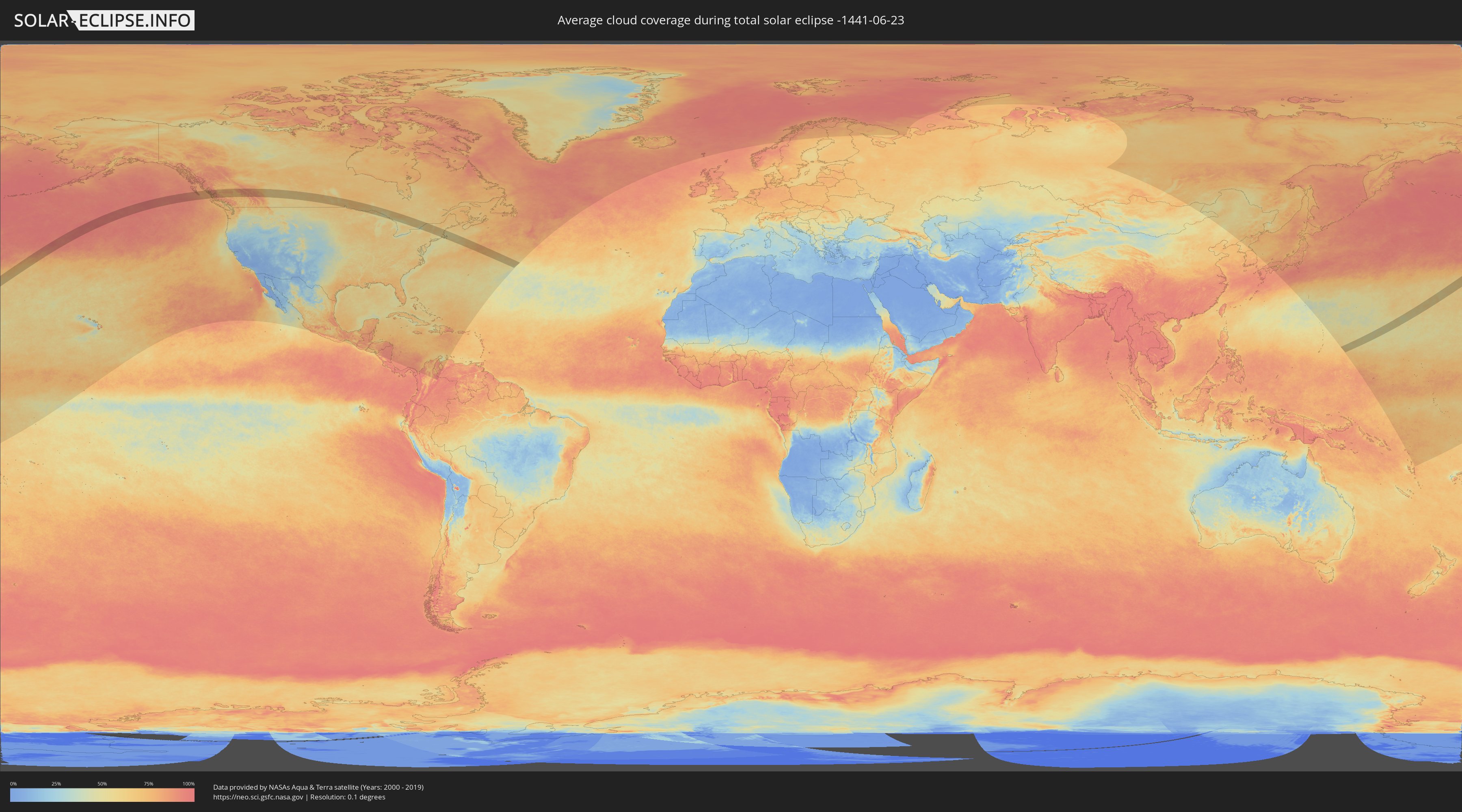
How will be the weather during the total solar eclipse on 06/23/-1441?
Where is the best place to see the total solar eclipse of 06/23/-1441?
The following maps show the average cloud coverage for the day of the total solar eclipse.
With the help of these maps, it is possible to find the place along the eclipse path, which has the best
chance of a cloudless sky.
Nevertheless, you should consider local circumstances and inform about the weather of your chosen
observation site.
The data is provided by NASAs satellites
AQUA and TERRA.
The cloud maps are averaged over a period of 19 years (2000 - 2019).
Detailed country maps
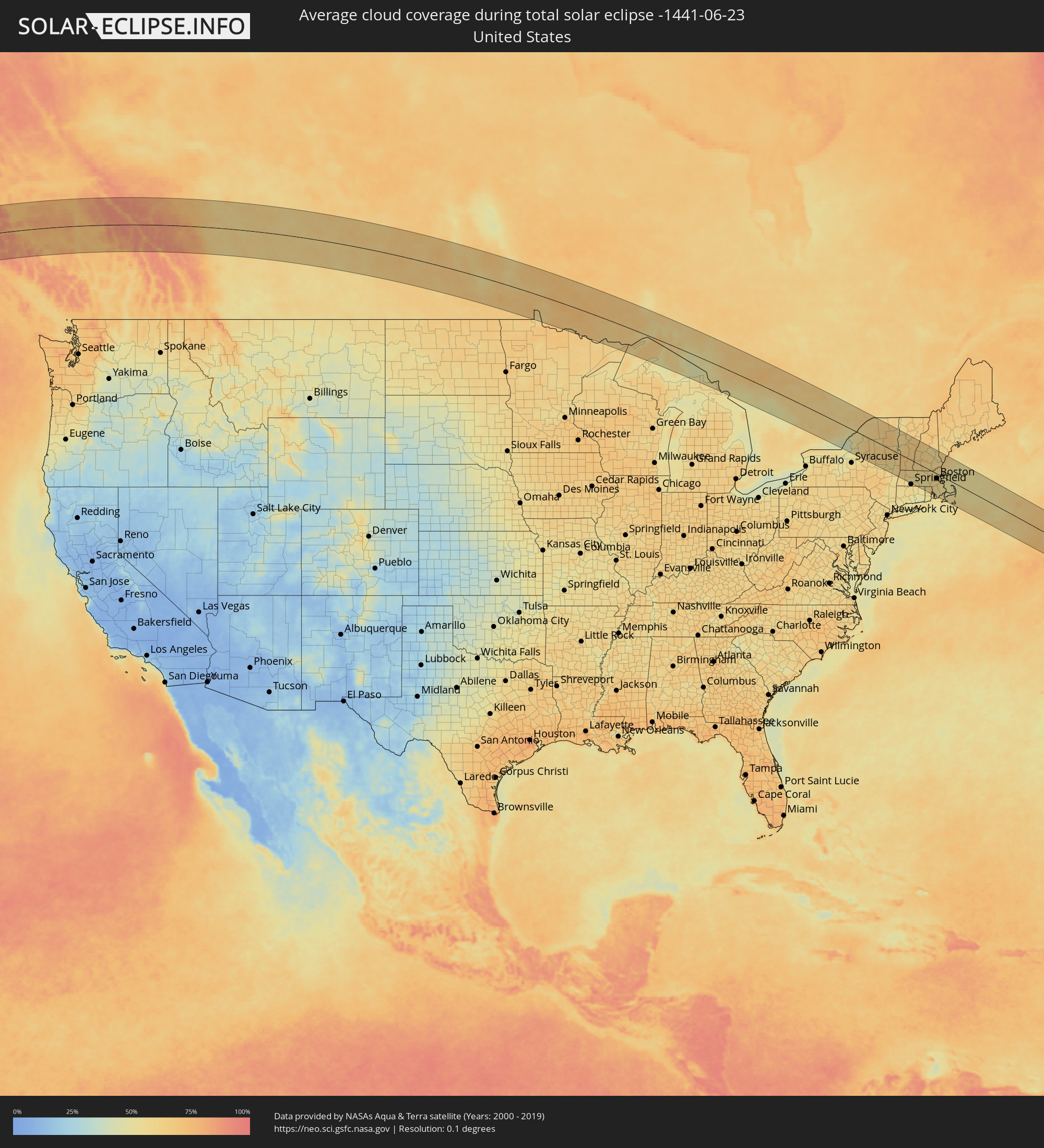 United States
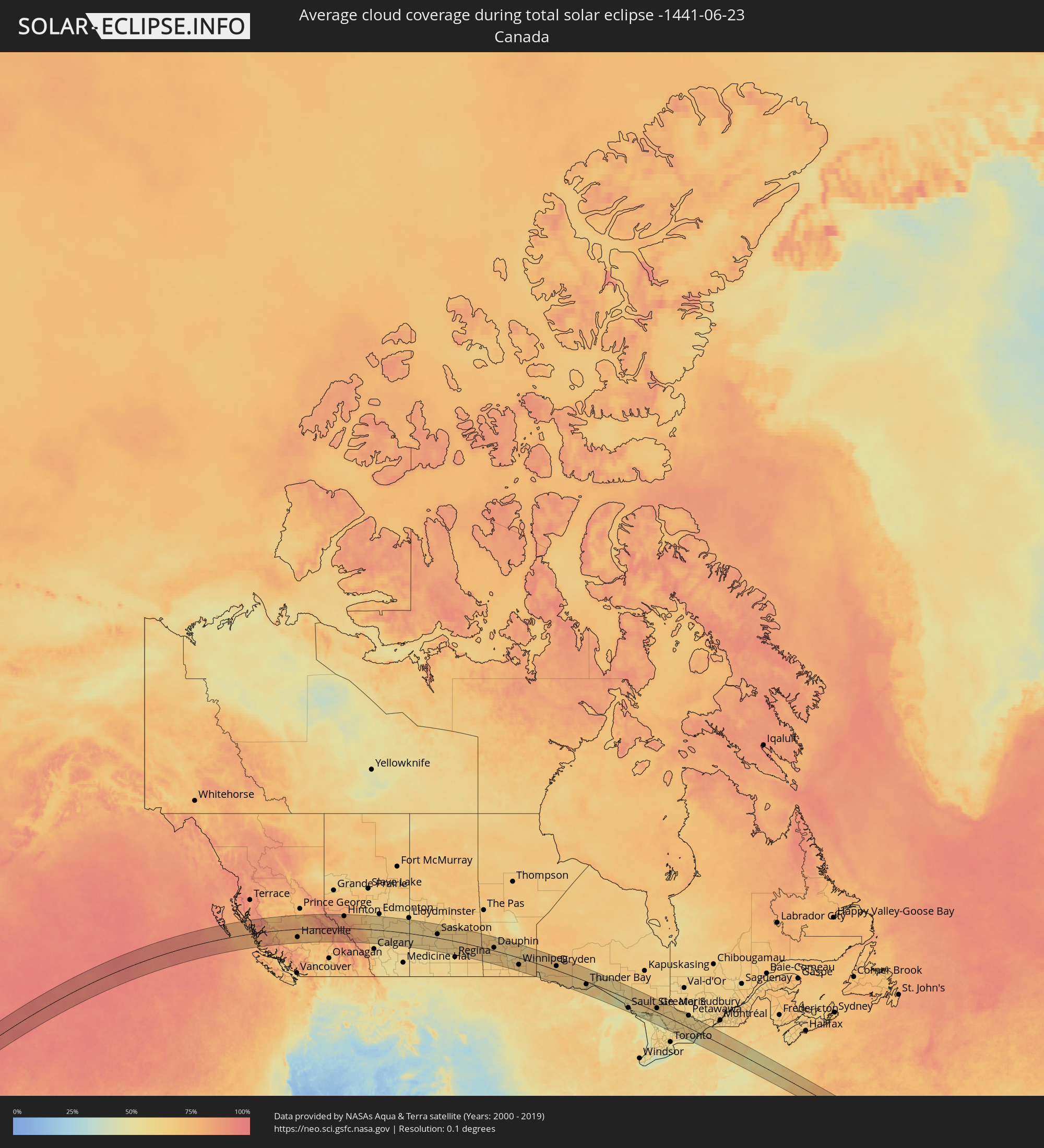 Canada
Cities inside the path of the eclipse
The following table shows all locations with a population of more than 5,000 inside the eclipse path. Cities which have more than 100,000 inhabitants are marked bold. A click at the locations opens a detailed map.
| City | Type | Eclipse duration | Local time of max. eclipse | Distance to central line | Ø Cloud coverage |
|
Hanceville, British Columbia
|
total | - | 13:32:27 UTC-08:00 | 65 km | 74% |
|
Quesnel, British Columbia
|
total | - | 13:32:55 UTC-08:00 | 51 km | 69% |
|
Williams Lake, British Columbia
|
total | - | 13:33:40 UTC-08:00 | 43 km | 72% |
|
Hinton, Alberta
|
total | - | 14:05:24 UTC-07:33 | 93 km | 79% |
|
Drayton Valley, Alberta
|
total | - | 14:08:47 UTC-07:33 | 81 km | 65% |
|
Rocky Mountain House, Alberta
|
total | - | 14:09:25 UTC-07:33 | 14 km | 63% |
|
Olds, Alberta
|
total | - | 14:10:51 UTC-07:33 | 75 km | 61% |
|
Sylvan Lake, Alberta
|
total | - | 14:10:30 UTC-07:33 | 15 km | 59% |
|
Red Deer, Alberta
|
total | - | 14:10:53 UTC-07:33 | 19 km | 62% |
|
Devon, Alberta
|
total | - | 14:10:12 UTC-07:33 | 103 km | 61% |
|
Lacombe, Alberta
|
total | - | 14:10:50 UTC-07:33 | 3 km | 58% |
|
Ponoka, Alberta
|
total | - | 14:10:52 UTC-07:33 | 27 km | 61% |
|
Leduc, Alberta
|
total | - | 14:10:29 UTC-07:33 | 93 km | 60% |
|
Beaumont, Alberta
|
total | - | 14:10:35 UTC-07:33 | 103 km | 63% |
|
Wetaskiwin, Alberta
|
total | - | 14:10:56 UTC-07:33 | 61 km | 60% |
|
Camrose, Alberta
|
total | - | 14:11:32 UTC-07:33 | 70 km | 59% |
|
Stettler, Alberta
|
total | - | 14:12:12 UTC-07:33 | 7 km | 60% |
|
Wainwright, Alberta
|
total | - | 14:14:01 UTC-07:33 | 64 km | 63% |
|
North Battleford, Saskatchewan
|
total | - | 14:52:13 UTC-06:58 | 82 km | 63% |
|
Saskatoon, Saskatchewan
|
total | - | 14:54:35 UTC-06:58 | 29 km | 64% |
|
Yorkton, Saskatchewan
|
total | - | 14:59:51 UTC-06:58 | 11 km | 64% |
|
Dauphin, Manitoba
|
total | - | 16:00:50 UTC-06:00 | 23 km | 65% |
|
Portage la Prairie, Manitoba
|
total | - | 16:03:46 UTC-06:00 | 70 km | 63% |
|
Winnipeg, Manitoba
|
total | - | 16:04:52 UTC-06:00 | 56 km | 75% |
|
Selkirk, Manitoba
|
total | - | 16:04:47 UTC-06:00 | 22 km | 66% |
|
Steinbach, Manitoba
|
total | - | 16:05:41 UTC-06:00 | 84 km | 67% |
|
Dryden, Ontario
|
total | - | 16:08:26 UTC-06:00 | 33 km | 70% |
|
Thunder Bay, Ontario
|
total | - | 17:12:34 UTC-05:00 | 23 km | 63% |
|
Sault Ste. Marie, Michigan
|
total | - | 17:17:42 UTC-05:00 | 74 km | 55% |
|
Sault Ste. Marie, Ontario
|
total | - | 17:17:41 UTC-05:00 | 71 km | 55% |
|
Elliot Lake, Ontario
|
total | - | 17:18:37 UTC-05:00 | 31 km | 57% |
|
Rayside-Balfour, Ontario
|
total | - | 17:18:55 UTC-05:00 | 38 km | 67% |
|
Greater Sudbury, Ontario
|
total | - | 17:19:09 UTC-05:00 | 33 km | 64% |
|
Parry Sound, Ontario
|
total | - | 17:20:58 UTC-05:00 | 50 km | 53% |
|
North Bay, Ontario
|
total | - | 17:19:56 UTC-05:00 | 66 km | 59% |
|
Gravenhurst, Ontario
|
total | - | 17:21:44 UTC-05:00 | 71 km | 55% |
|
Bracebridge, Ontario
|
total | - | 17:21:36 UTC-05:00 | 57 km | 57% |
|
Huntsville, Ontario
|
total | - | 17:21:16 UTC-05:00 | 24 km | 60% |
|
Peterborough, Ontario
|
total | - | 17:22:51 UTC-05:00 | 96 km | 63% |
|
Quinte West, Ontario
|
total | - | 17:23:12 UTC-05:00 | 81 km | 56% |
|
Belleville, Ontario
|
total | - | 17:23:17 UTC-05:00 | 76 km | 55% |
|
Petawawa, Ontario
|
total | - | 17:21:08 UTC-05:00 | 99 km | 60% |
|
Prince Edward, Ontario
|
total | - | 17:23:31 UTC-05:00 | 88 km | 45% |
|
Pembroke, Ontario
|
total | - | 17:21:17 UTC-05:00 | 97 km | 56% |
|
Greater Napanee, Ontario
|
total | - | 17:23:18 UTC-05:00 | 53 km | 54% |
|
Renfrew, Ontario
|
total | - | 17:21:50 UTC-05:00 | 78 km | 58% |
|
Kingston, Ontario
|
total | - | 17:23:26 UTC-05:00 | 38 km | 46% |
|
Arnprior, Ontario
|
total | - | 17:21:58 UTC-05:00 | 86 km | 60% |
|
Perth, Ontario
|
total | - | 17:22:40 UTC-05:00 | 37 km | 57% |
|
Gananoque, Ontario
|
total | - | 17:23:23 UTC-05:00 | 16 km | 48% |
|
Carleton Place, Ontario
|
total | - | 17:22:24 UTC-05:00 | 64 km | 61% |
|
Smiths Falls, Ontario
|
total | - | 17:22:43 UTC-05:00 | 45 km | 59% |
|
Watertown, New York
|
total | - | 17:23:53 UTC-05:00 | 43 km | 54% |
|
Bells Corners, Ontario
|
total | - | 17:22:15 UTC-05:00 | 93 km | 61% |
|
Fort Drum, New York
|
total | - | 17:23:49 UTC-05:00 | 29 km | 57% |
|
Brockville, Ontario
|
total | - | 17:23:11 UTC-05:00 | 26 km | 56% |
|
Ogdensburg, New York
|
total | - | 17:23:06 UTC-05:00 | 44 km | 59% |
|
Potsdam, New York
|
total | - | 17:23:14 UTC-05:00 | 60 km | 61% |
|
Massena, New York
|
total | - | 17:22:56 UTC-05:00 | 88 km | 61% |
|
Gloversville, New York
|
total | - | 17:25:21 UTC-05:00 | 77 km | 57% |
|
Amsterdam, New York
|
total | - | 17:25:30 UTC-05:00 | 82 km | 57% |
|
Scotia, New York
|
total | - | 17:25:41 UTC-05:00 | 85 km | 58% |
|
Schenectady, New York
|
total | - | 17:25:42 UTC-05:00 | 85 km | 56% |
|
Westmere, New York
|
total | - | 17:25:52 UTC-05:00 | 95 km | 58% |
|
Colonie, New York
|
total | - | 17:25:50 UTC-05:00 | 91 km | 59% |
|
Delmar, New York
|
total | - | 17:25:57 UTC-05:00 | 100 km | 56% |
|
Saratoga Springs, New York
|
total | - | 17:25:24 UTC-05:00 | 53 km | 59% |
|
Albany, New York
|
total | - | 17:25:56 UTC-05:00 | 95 km | 59% |
|
Glens Falls, New York
|
total | - | 17:25:09 UTC-05:00 | 25 km | 59% |
|
Pittsfield, Massachusetts
|
total | - | 17:26:15 UTC-05:00 | 95 km | 61% |
|
Bennington, Vermont
|
total | - | 17:25:45 UTC-05:00 | 51 km | 64% |
|
North Adams, Massachusetts
|
total | - | 17:25:58 UTC-05:00 | 65 km | 63% |
|
Rutland, Vermont
|
total | - | 17:24:54 UTC-05:00 | 29 km | 63% |
|
Northampton, Massachusetts
|
total | - | 17:26:29 UTC-05:00 | 85 km | 56% |
|
North Chicopee, Massachusetts
|
total | - | 17:26:40 UTC-05:00 | 97 km | 58% |
|
Greenfield, Massachusetts
|
total | - | 17:26:11 UTC-05:00 | 57 km | 57% |
|
Brattleboro, Vermont
|
total | - | 17:25:52 UTC-05:00 | 30 km | 60% |
|
Claremont, New Hampshire
|
total | - | 17:25:16 UTC-05:00 | 30 km | 63% |
|
Palmer, Massachusetts
|
total | - | 17:26:43 UTC-05:00 | 89 km | 56% |
|
Keene, New Hampshire
|
total | - | 17:25:49 UTC-05:00 | 11 km | 61% |
|
Lebanon, New Hampshire
|
total | - | 17:24:58 UTC-05:00 | 60 km | 64% |
|
Athol, Massachusetts
|
total | - | 17:26:13 UTC-05:00 | 42 km | 55% |
|
Southbridge, Massachusetts
|
total | - | 17:26:51 UTC-05:00 | 86 km | 54% |
|
Gardner, Massachusetts
|
total | - | 17:26:16 UTC-05:00 | 36 km | 60% |
|
Thompson, Connecticut
|
total | - | 17:27:01 UTC-05:00 | 91 km | 55% |
|
Worcester, Massachusetts
|
total | - | 17:26:40 UTC-05:00 | 59 km | 54% |
|
West Boylston, Massachusetts
|
total | - | 17:26:33 UTC-05:00 | 48 km | 54% |
|
Sterling, Massachusetts
|
total | - | 17:26:28 UTC-05:00 | 40 km | 54% |
|
Leominster, Massachusetts
|
total | - | 17:26:22 UTC-05:00 | 31 km | 54% |
|
Weare, New Hampshire
|
total | - | 17:25:41 UTC-05:00 | 26 km | 61% |
|
Clinton, Massachusetts
|
total | - | 17:26:30 UTC-05:00 | 39 km | 54% |
|
Lancaster, Massachusetts
|
total | - | 17:26:27 UTC-05:00 | 35 km | 57% |
|
Milford, New Hampshire
|
total | - | 17:26:00 UTC-05:00 | 3 km | 58% |
|
Franklin, New Hampshire
|
total | - | 17:25:17 UTC-05:00 | 63 km | 60% |
|
Hollis, New Hampshire
|
total | - | 17:26:07 UTC-05:00 | 4 km | 56% |
|
Hudson, Massachusetts
|
total | - | 17:26:32 UTC-05:00 | 37 km | 56% |
|
Concord, New Hampshire
|
total | - | 17:25:34 UTC-05:00 | 44 km | 60% |
|
Milford, Massachusetts
|
total | - | 17:26:50 UTC-05:00 | 60 km | 57% |
|
Woonsocket, Rhode Island
|
total | - | 17:27:00 UTC-05:00 | 73 km | 57% |
|
Bow Bog, New Hampshire
|
total | - | 17:25:41 UTC-05:00 | 37 km | 58% |
|
Litchfield, New Hampshire
|
total | - | 17:26:01 UTC-05:00 | 11 km | 59% |
|
Laconia, New Hampshire
|
total | - | 17:25:12 UTC-05:00 | 78 km | 61% |
|
Nashua, New Hampshire
|
total | - | 17:26:06 UTC-05:00 | 3 km | 59% |
|
Cumberland Hill, Rhode Island
|
total | - | 17:27:02 UTC-05:00 | 74 km | 57% |
|
Pembroke, New Hampshire
|
total | - | 17:25:39 UTC-05:00 | 41 km | 58% |
|
Manchester, New Hampshire
|
total | - | 17:25:50 UTC-05:00 | 27 km | 59% |
|
Hudson, New Hampshire
|
total | - | 17:26:07 UTC-05:00 | 4 km | 58% |
|
Acton, Massachusetts
|
total | - | 17:26:27 UTC-05:00 | 23 km | 60% |
|
Framingham, Massachusetts
|
total | - | 17:26:41 UTC-05:00 | 42 km | 58% |
|
Providence, Rhode Island
|
total | - | 17:27:13 UTC-05:00 | 87 km | 58% |
|
Gilford, New Hampshire
|
total | - | 17:25:11 UTC-05:00 | 83 km | 60% |
|
Millis, Massachusetts
|
total | - | 17:26:49 UTC-05:00 | 51 km | 60% |
|
Plainville, Massachusetts
|
total | - | 17:27:01 UTC-05:00 | 66 km | 60% |
|
Norfolk, Massachusetts
|
total | - | 17:26:53 UTC-05:00 | 55 km | 59% |
|
Lowell, Massachusetts
|
total | - | 17:26:17 UTC-05:00 | 4 km | 61% |
|
Derry Village, New Hampshire
|
total | - | 17:25:58 UTC-05:00 | 22 km | 58% |
|
Lincoln, Massachusetts
|
total | - | 17:26:32 UTC-05:00 | 24 km | 59% |
|
Attleboro, Massachusetts
|
total | - | 17:27:05 UTC-05:00 | 70 km | 59% |
|
Needham, Massachusetts
|
total | - | 17:26:42 UTC-05:00 | 35 km | 59% |
|
Mansfield Center, Massachusetts
|
total | - | 17:27:00 UTC-05:00 | 60 km | 57% |
|
Tiverton, Rhode Island
|
total | - | 17:27:28 UTC-05:00 | 99 km | 48% |
|
Fall River, Massachusetts
|
total | - | 17:27:23 UTC-05:00 | 89 km | 49% |
|
Woburn, Massachusetts
|
total | - | 17:26:29 UTC-05:00 | 13 km | 60% |
|
Plaistow, New Hampshire
|
total | - | 17:26:04 UTC-05:00 | 25 km | 58% |
|
Taunton, Massachusetts
|
total | - | 17:27:10 UTC-05:00 | 67 km | 56% |
|
Haverhill, Massachusetts
|
total | - | 17:26:08 UTC-05:00 | 19 km | 58% |
|
Boston, Massachusetts
|
total | - | 17:26:38 UTC-05:00 | 21 km | 61% |
|
Barrington, New Hampshire
|
total | - | 17:25:36 UTC-05:00 | 64 km | 59% |
|
Brockton, Massachusetts
|
total | - | 17:26:57 UTC-05:00 | 46 km | 57% |
|
Middleton, Massachusetts
|
total | - | 17:26:21 UTC-05:00 | 4 km | 56% |
|
Bridgewater, Massachusetts
|
total | - | 17:27:04 UTC-05:00 | 54 km | 57% |
|
Lynn, Massachusetts
|
total | - | 17:26:31 UTC-05:00 | 6 km | 60% |
|
Weymouth, Massachusetts
|
total | - | 17:26:48 UTC-05:00 | 30 km | 57% |
|
New Bedford, Massachusetts
|
total | - | 17:27:29 UTC-05:00 | 87 km | 59% |
|
Amesbury, Massachusetts
|
total | - | 17:26:03 UTC-05:00 | 33 km | 58% |
|
Middleborough Center, Massachusetts
|
total | - | 17:27:11 UTC-05:00 | 61 km | 52% |
|
Dover, New Hampshire
|
total | - | 17:25:39 UTC-05:00 | 69 km | 58% |
|
Halifax, Massachusetts
|
total | - | 17:27:05 UTC-05:00 | 49 km | 56% |
|
Hanover, Massachusetts
|
total | - | 17:26:56 UTC-05:00 | 35 km | 52% |
|
South Berwick, Maine
|
total | - | 17:25:37 UTC-05:00 | 75 km | 55% |
|
Cohasset, Massachusetts
|
total | - | 17:26:47 UTC-05:00 | 22 km | 54% |
|
Sanford, Maine
|
total | - | 17:25:23 UTC-05:00 | 96 km | 61% |
|
Portsmouth, New Hampshire
|
total | - | 17:25:49 UTC-05:00 | 61 km | 56% |
|
Kingston, Massachusetts
|
total | - | 17:27:05 UTC-05:00 | 44 km | 54% |
|
Plymouth, Massachusetts
|
total | - | 17:27:08 UTC-05:00 | 45 km | 54% |
|
Gloucester, Massachusetts
|
total | - | 17:26:22 UTC-05:00 | 20 km | 57% |
|
York Beach, Maine
|
total | - | 17:25:43 UTC-05:00 | 76 km | 63% |
|
Wells Beach Station, Maine
|
total | - | 17:25:32 UTC-05:00 | 92 km | 63% |
|
Mashpee, Massachusetts
|
total | - | 17:27:30 UTC-05:00 | 68 km | 55% |
|
Marstons Mills, Massachusetts
|
total | - | 17:27:30 UTC-05:00 | 65 km | 50% |
|
Barnstable, Massachusetts
|
total | - | 17:27:27 UTC-05:00 | 56 km | 52% |
|
Nantucket, Massachusetts
|
total | - | 17:27:57 UTC-05:00 | 89 km | 55% |
|
Harwich, Massachusetts
|
total | - | 17:27:29 UTC-05:00 | 49 km | 53% |