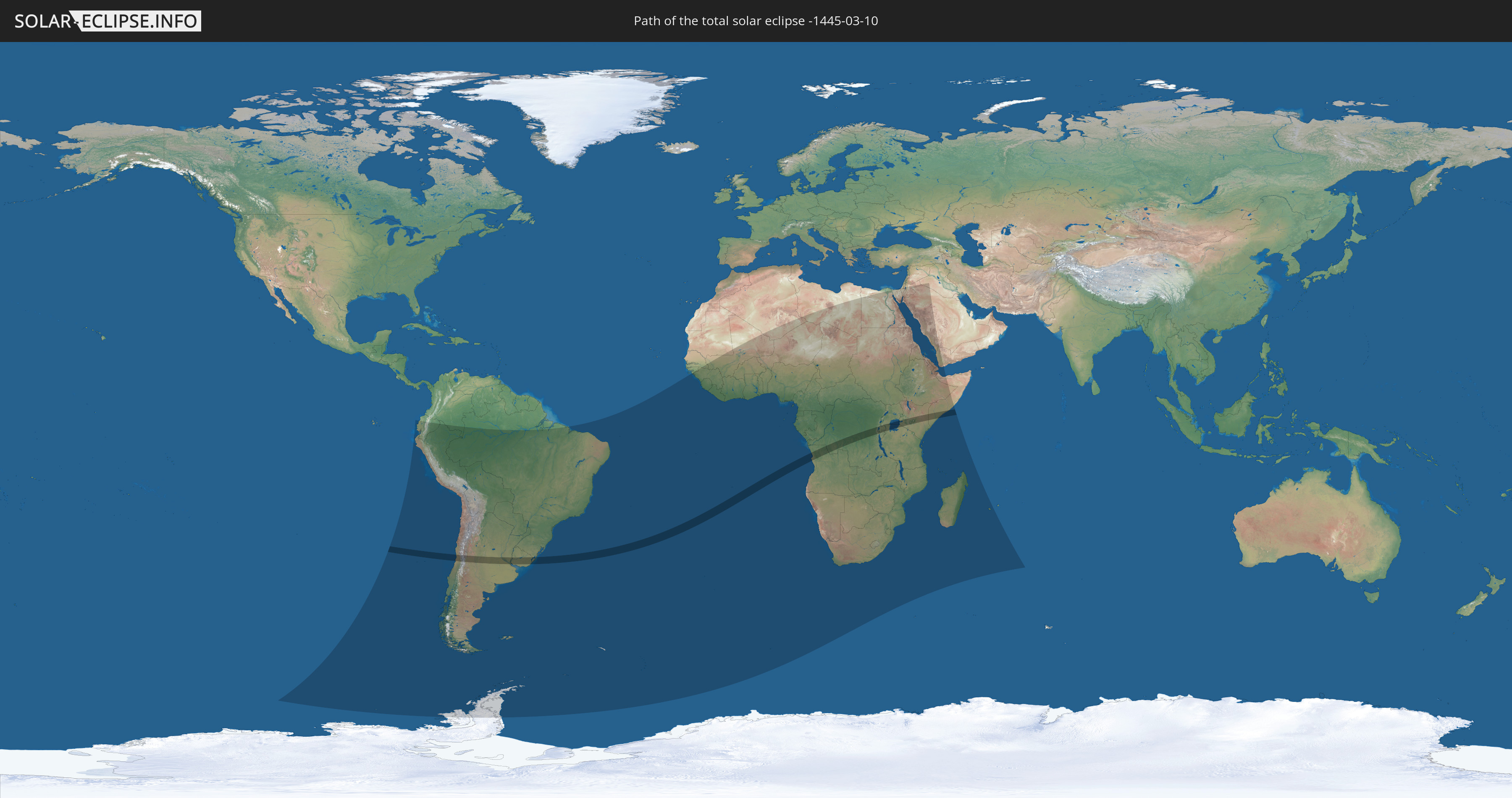
Total solar eclipse of 03/10/-1445
| Day of week: | Saturday |
| Maximum duration of eclipse: | 05m10s |
| Maximum width of eclipse path: | 201 km |
| Saros cycle: | 26 |
| Coverage: | 100% |
| Magnitude: | 1.0593 |
| Gamma: | -0.2507 |
Wo kann man die Sonnenfinsternis vom 03/10/-1445 sehen?
Die Sonnenfinsternis am 03/10/-1445 kann man in 71 Ländern als partielle Sonnenfinsternis beobachten.
Der Finsternispfad verläuft durch 12 Länder. Nur in diesen Ländern ist sie als total Sonnenfinsternis zu sehen.
In den folgenden Ländern ist die Sonnenfinsternis total zu sehen
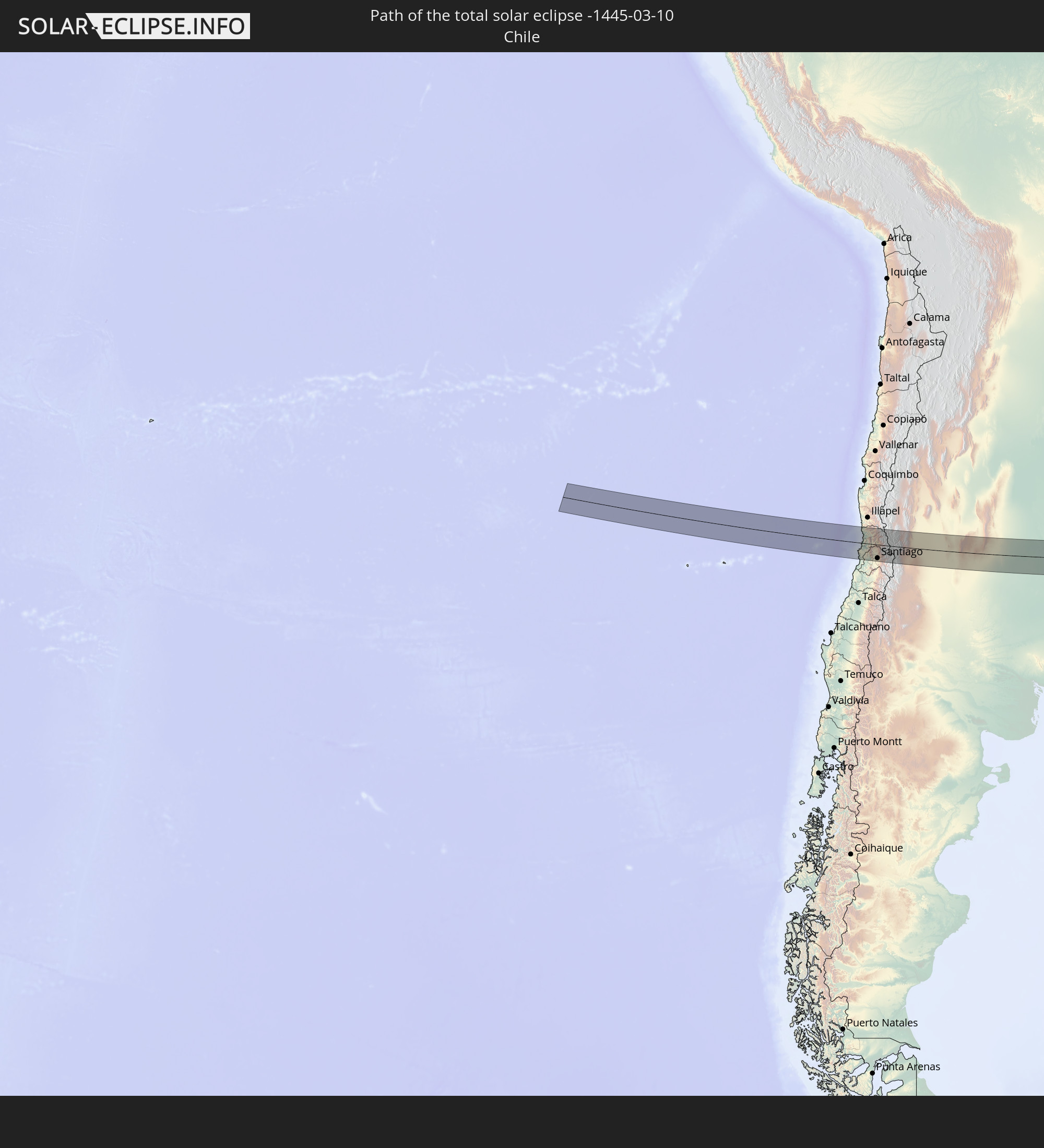 Chile
Chile
 Brazil
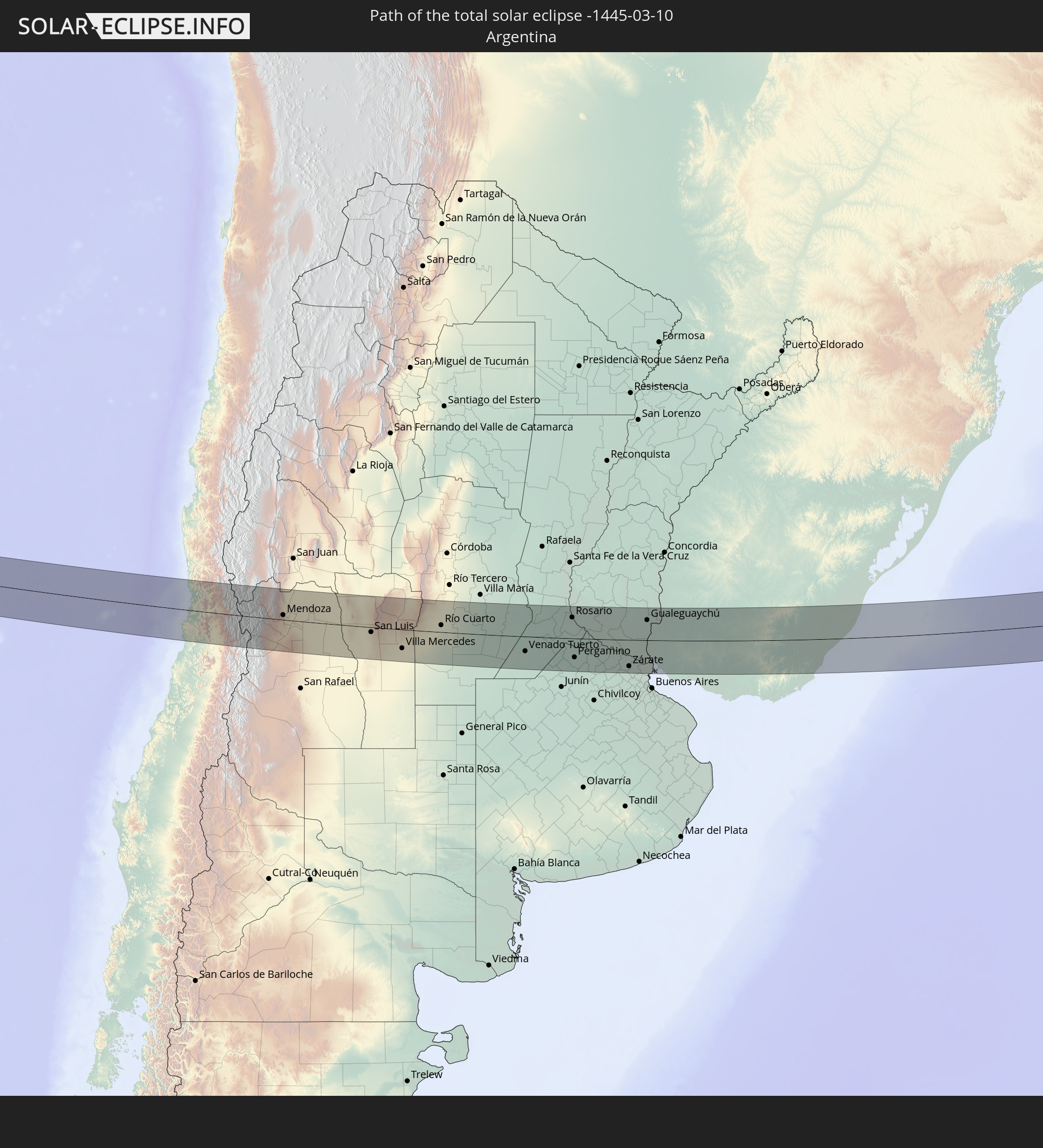 Argentina
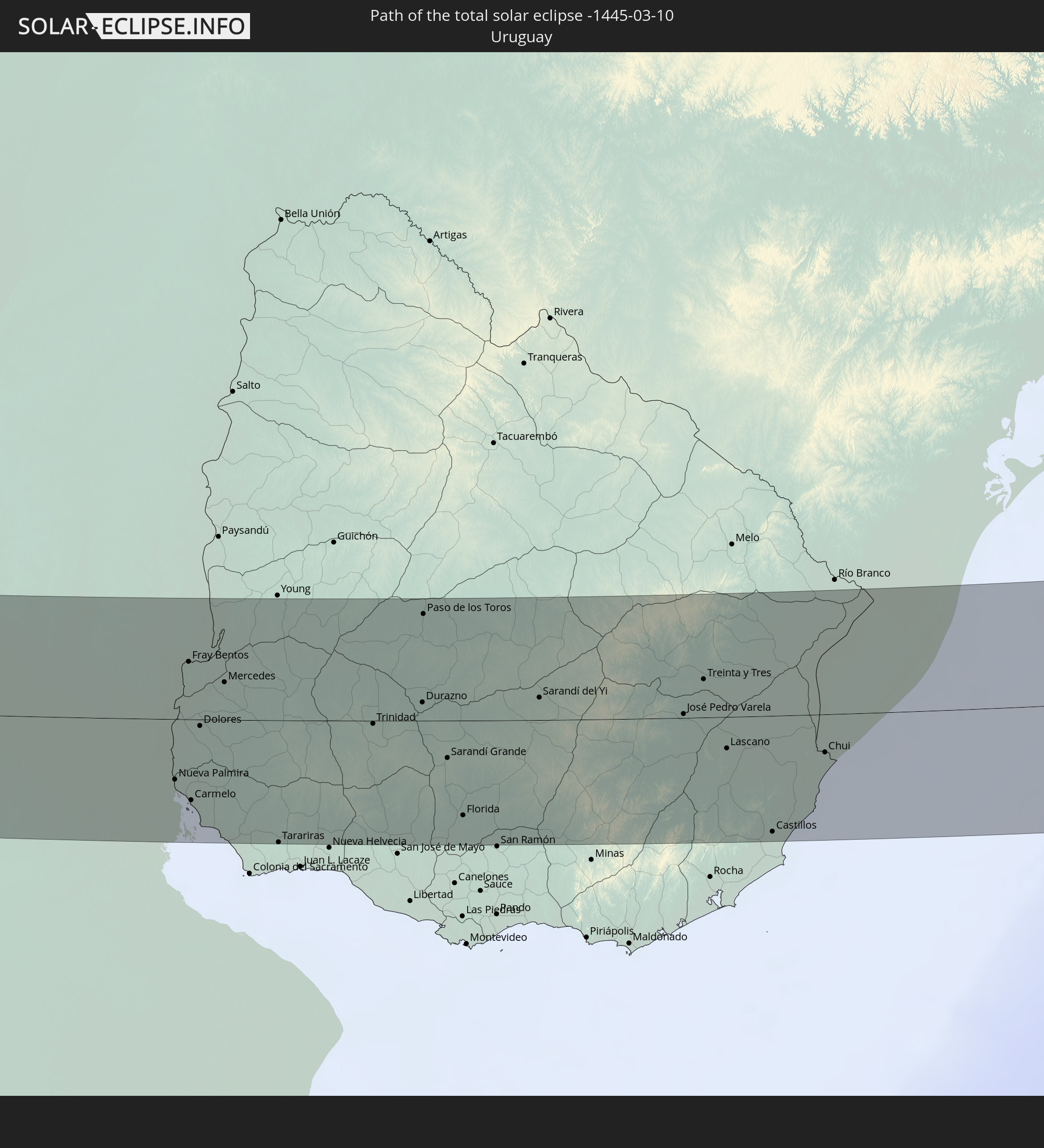 Uruguay
 Angola
 Democratic Republic of the Congo
 Rwanda
 Burundi
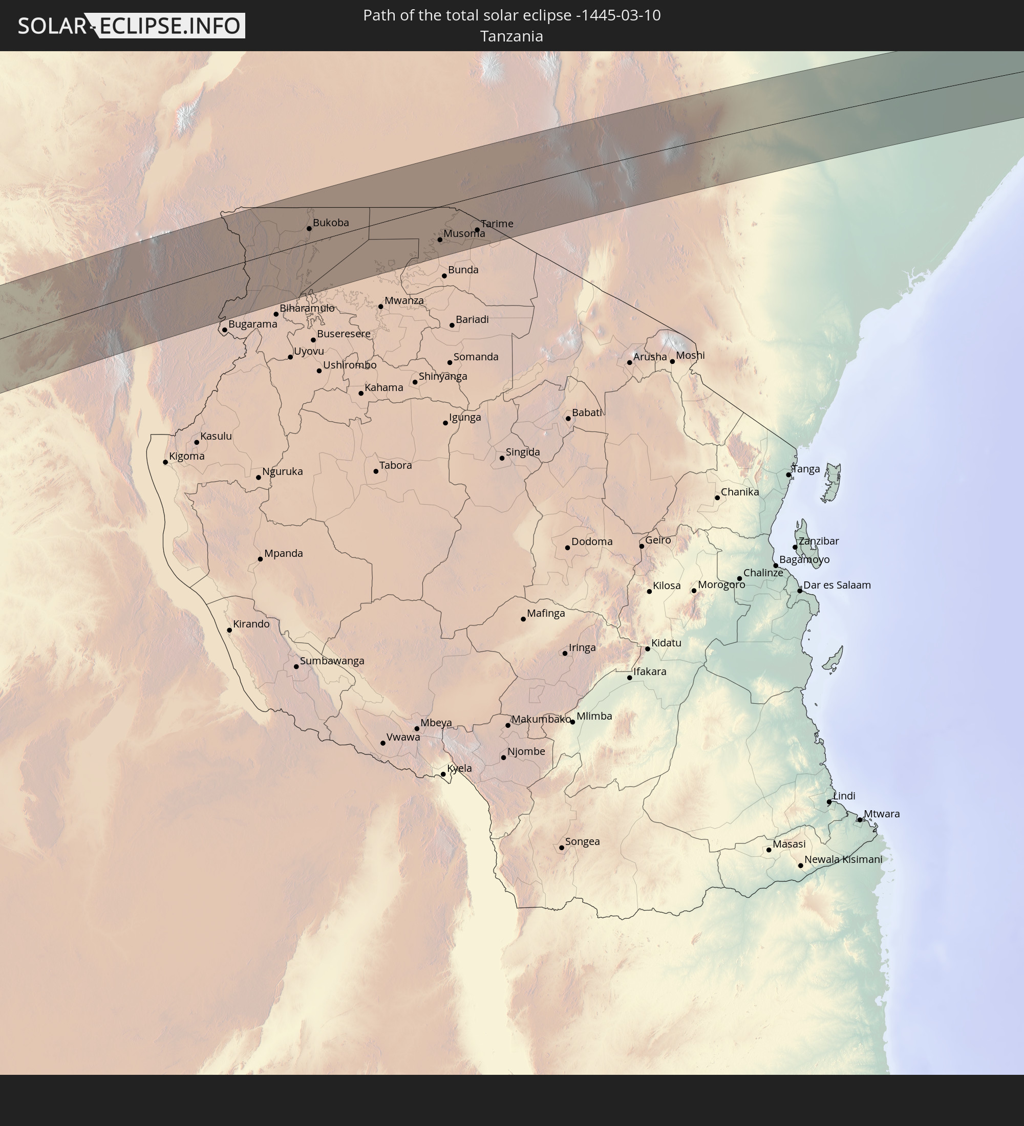 Tanzania
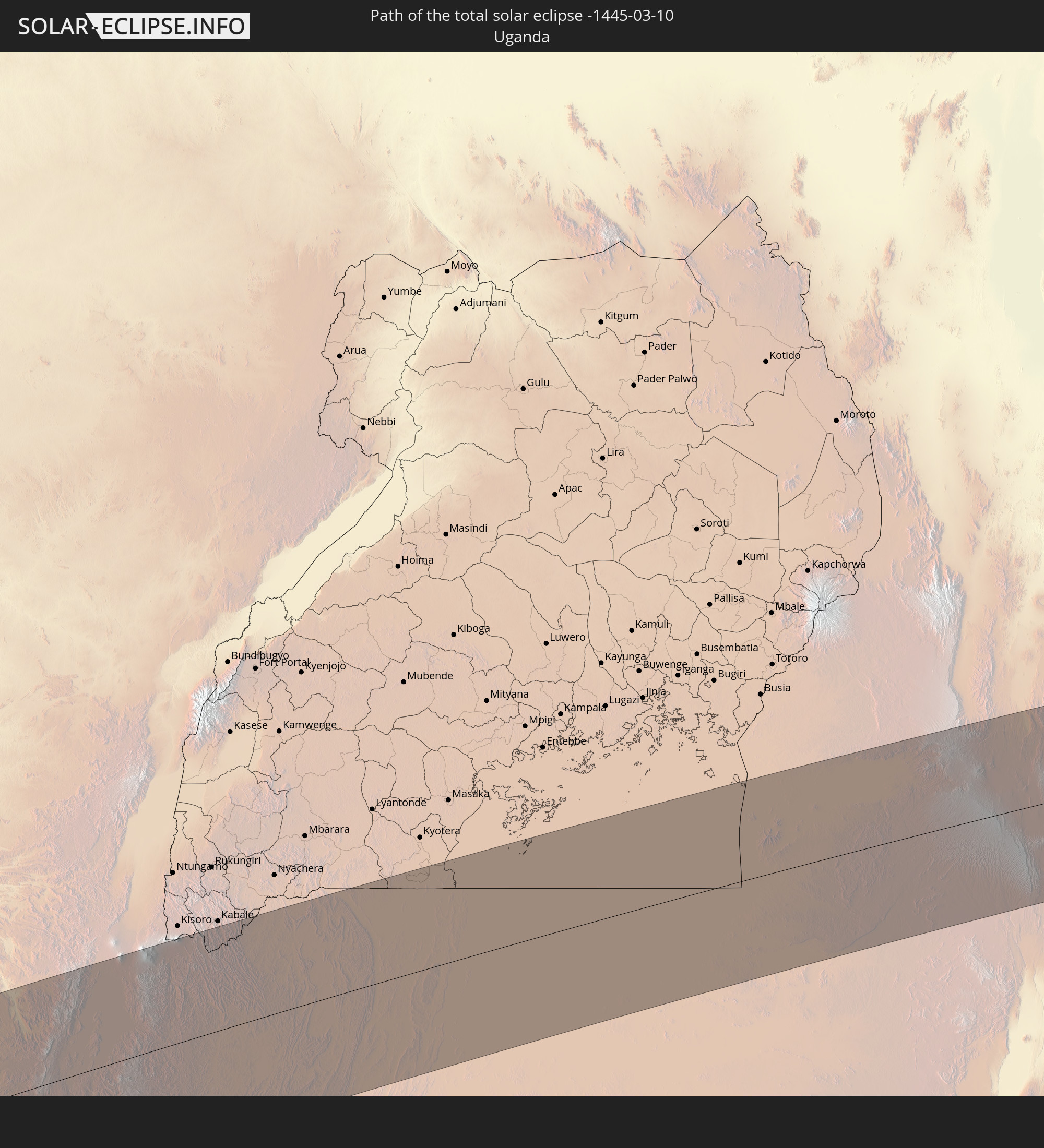 Uganda
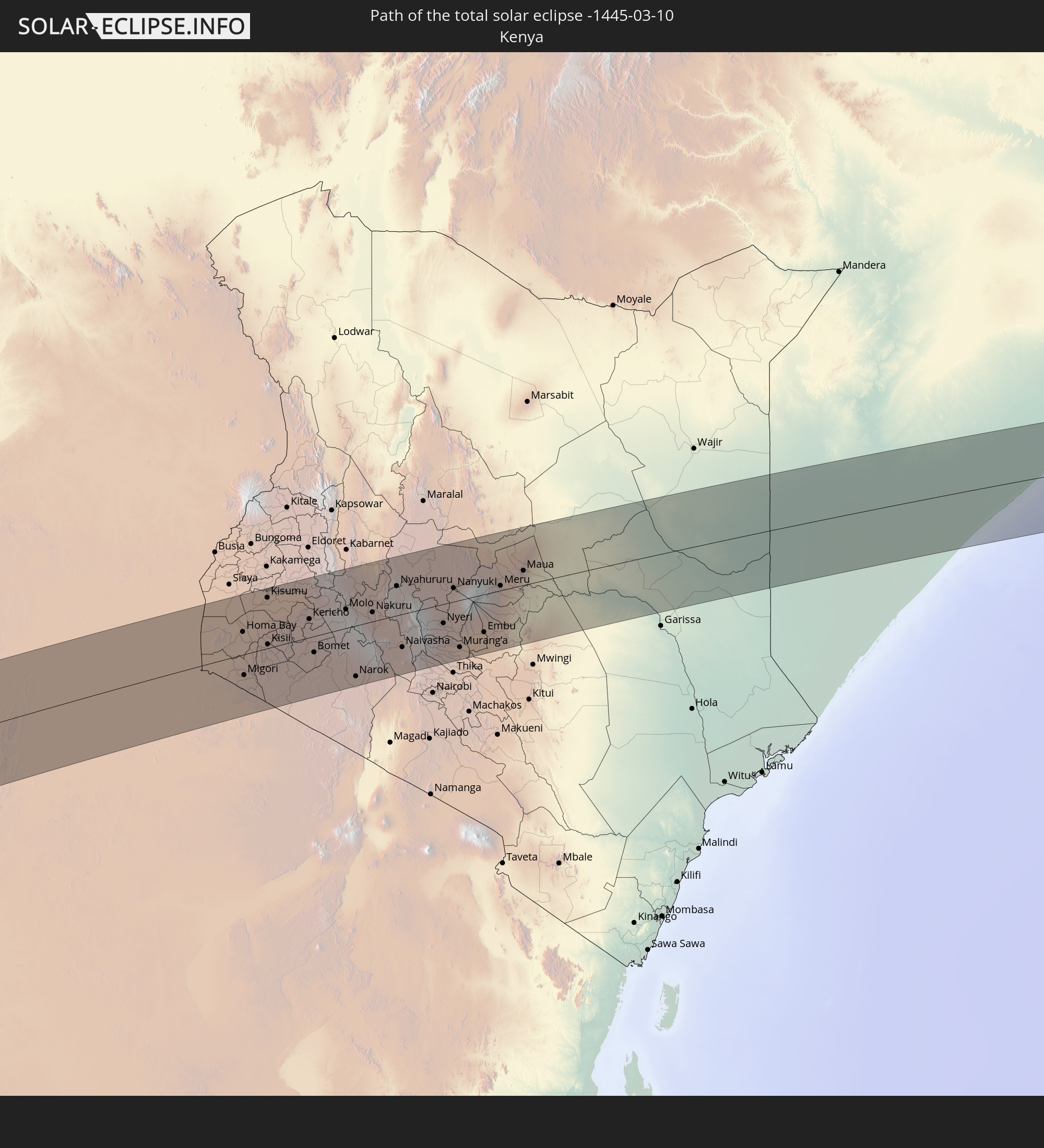 Kenya
Kenya
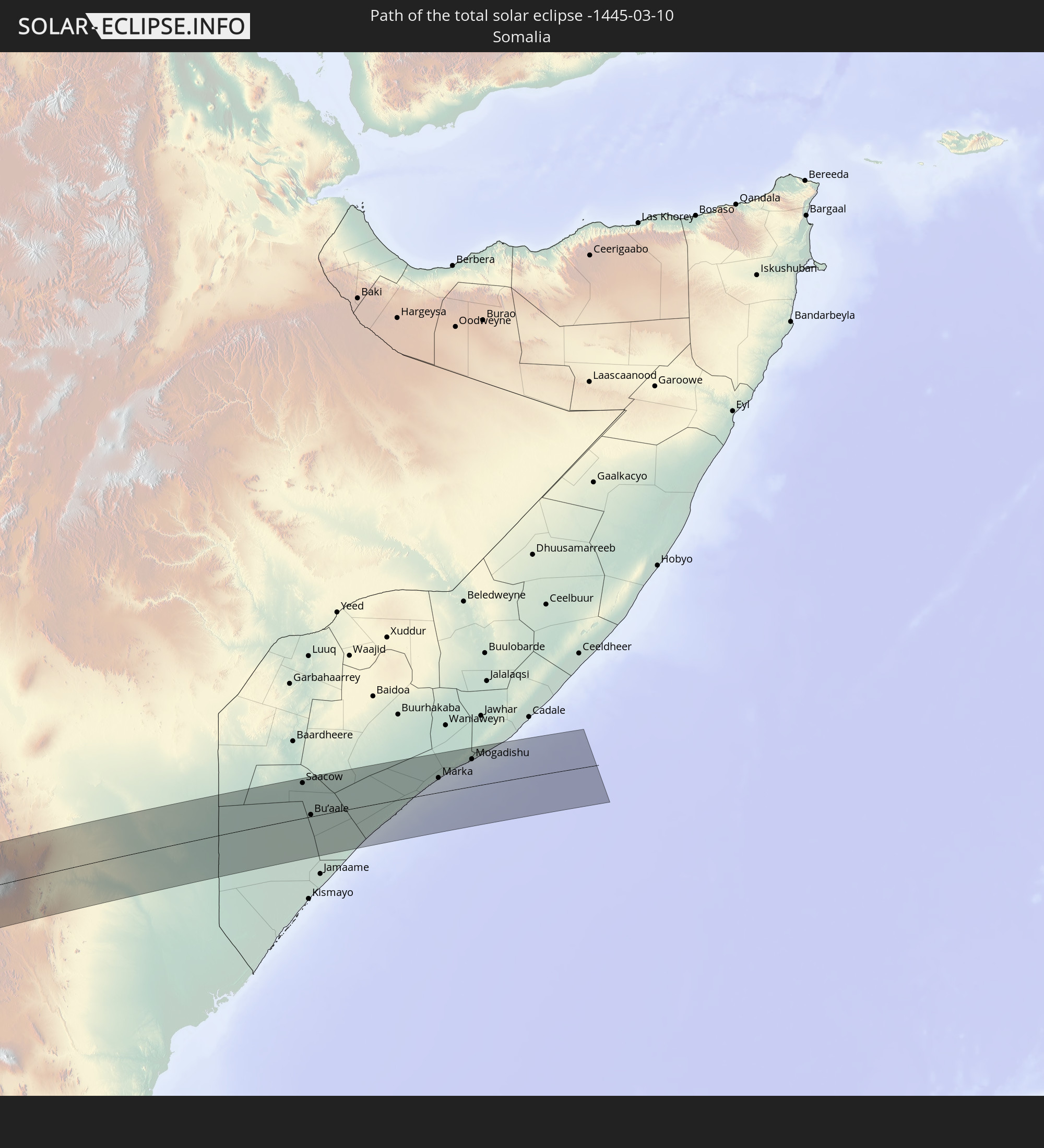 Somalia
In den folgenden Ländern ist die Sonnenfinsternis partiell zu sehen
 Antarctica
 Chile
Chile
 Ecuador
 Colombia
 Peru
Peru
 Brazil
 Argentina
 Bolivia
 Paraguay
 Falkland Islands
 Uruguay
 South Georgia and the South Sandwich Islands
 Senegal
 Mauritania
 Guinea-Bissau
 Guinea
 Saint Helena, Ascension and Tristan da Cunha
 Sierra Leone
 Mali
Mali
 Liberia
 Algeria
 Ivory Coast
 Burkina Faso
 Ghana
Ghana
 Togo
Togo
 Niger
Niger
 Benin
Benin
 Nigeria
 Bouvet Island
 Equatorial Guinea
 São Tomé and Príncipe
 Cameroon
 Gabon
Gabon
 Libya
Libya
 Republic of the Congo
 Angola
 Namibia
 Democratic Republic of the Congo
 Chad
Chad
 Central African Republic
 South Africa
 Botswana
 Sudan
Sudan
 Zambia
 Egypt
Egypt
 Zimbabwe
 Lesotho
 Rwanda
 Burundi
 Tanzania
 Uganda
 Mozambique
 Swaziland
 Malawi
 Ethiopia
 Kenya
Kenya
 State of Palestine
 Israel
 Saudi Arabia
 Jordan
 Eritrea
 Iraq
Iraq
 French Southern and Antarctic Lands
 Somalia
 Djibouti
 Yemen
Yemen
 Madagascar
 Comoros
 Mayotte
 Seychelles
 Réunion
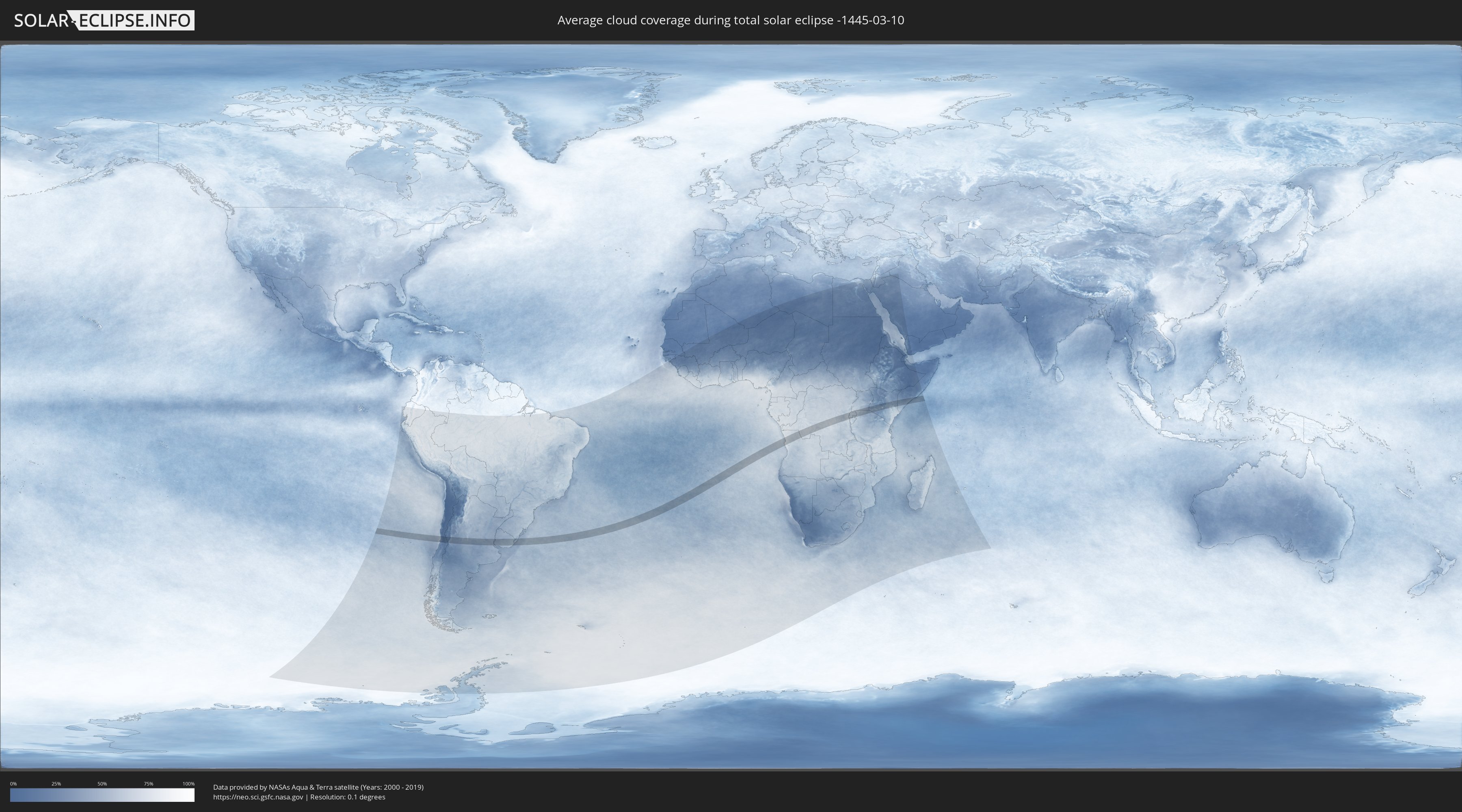
How will be the weather during the total solar eclipse on 03/10/-1445?
Where is the best place to see the total solar eclipse of 03/10/-1445?
The following maps show the average cloud coverage for the day of the total solar eclipse.
With the help of these maps, it is possible to find the place along the eclipse path, which has the best
chance of a cloudless sky.
Nevertheless, you should consider local circumstances and inform about the weather of your chosen
observation site.
The data is provided by NASAs satellites
AQUA and TERRA.
The cloud maps are averaged over a period of 19 years (2000 - 2019).

Detailed country maps
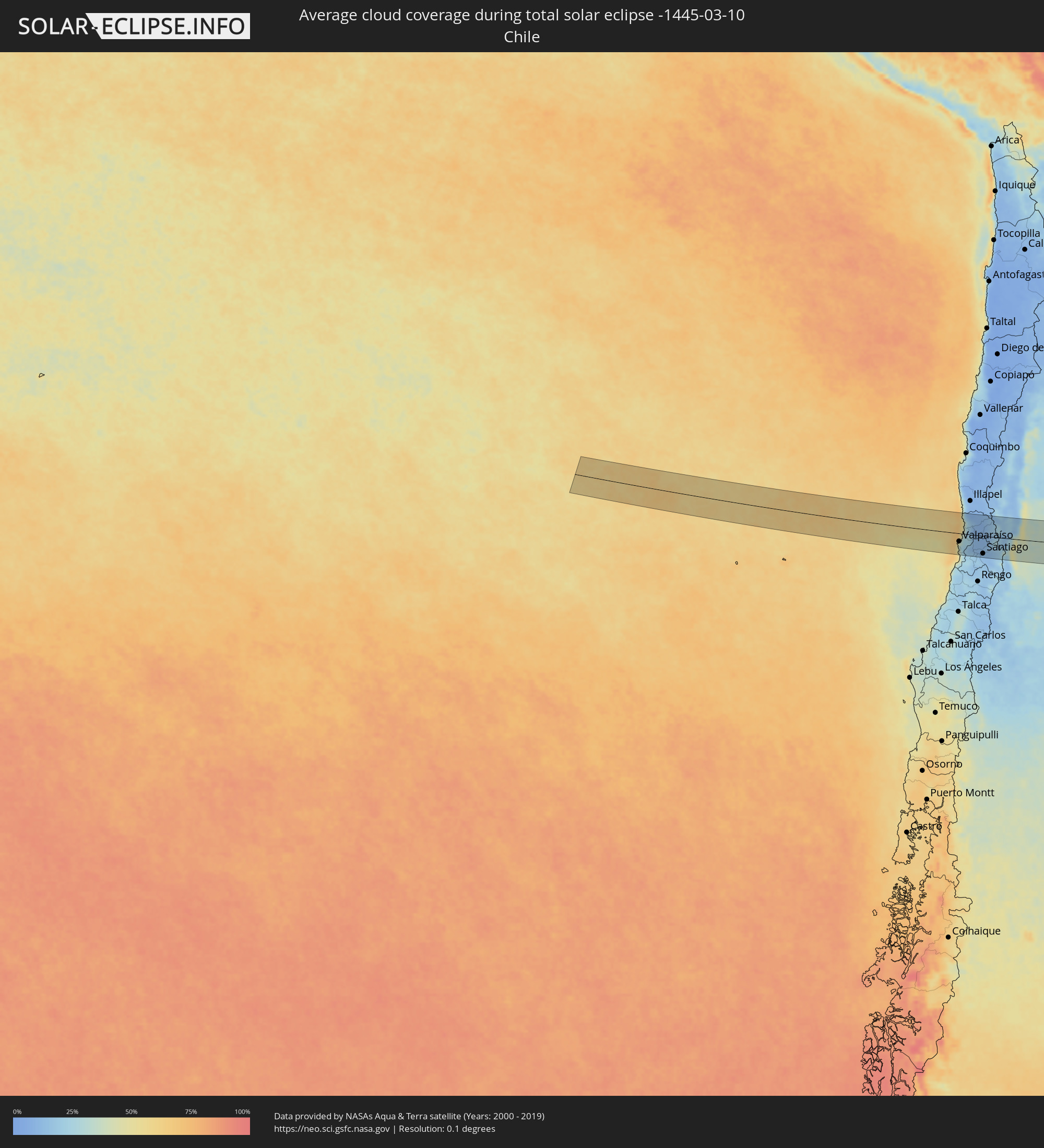 Chile
Chile
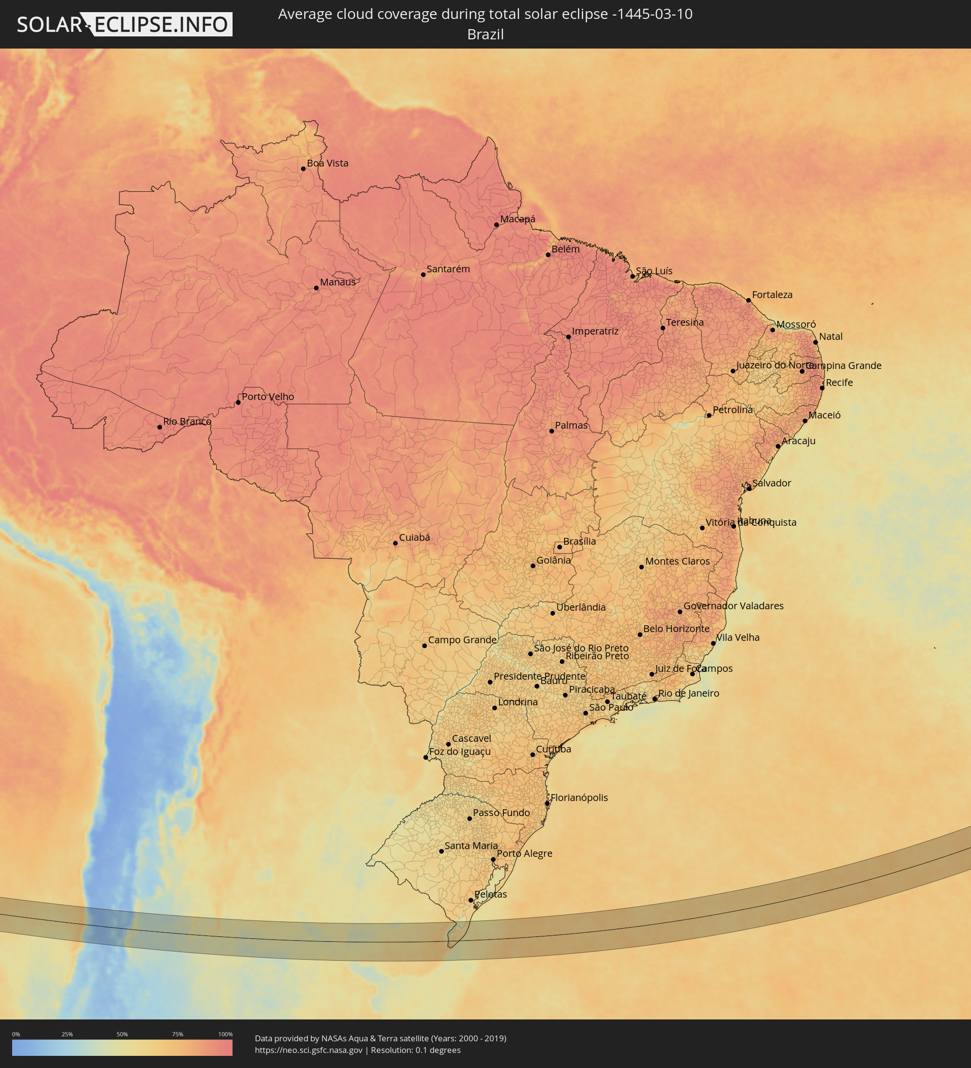 Brazil
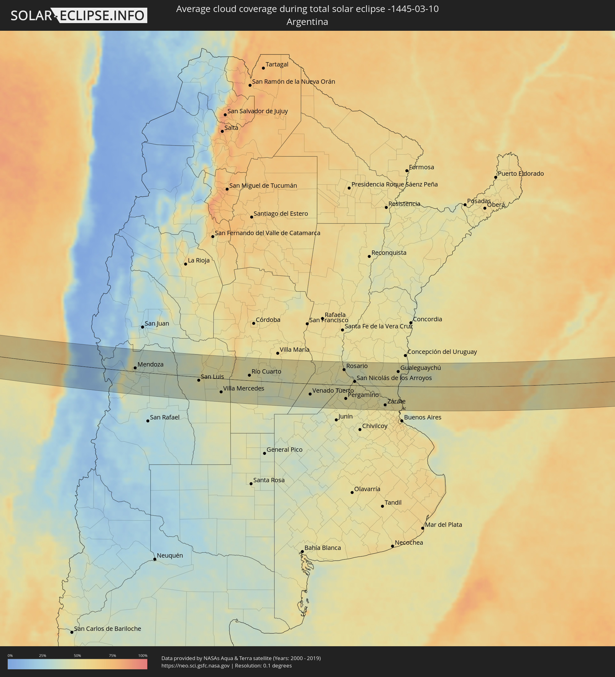 Argentina
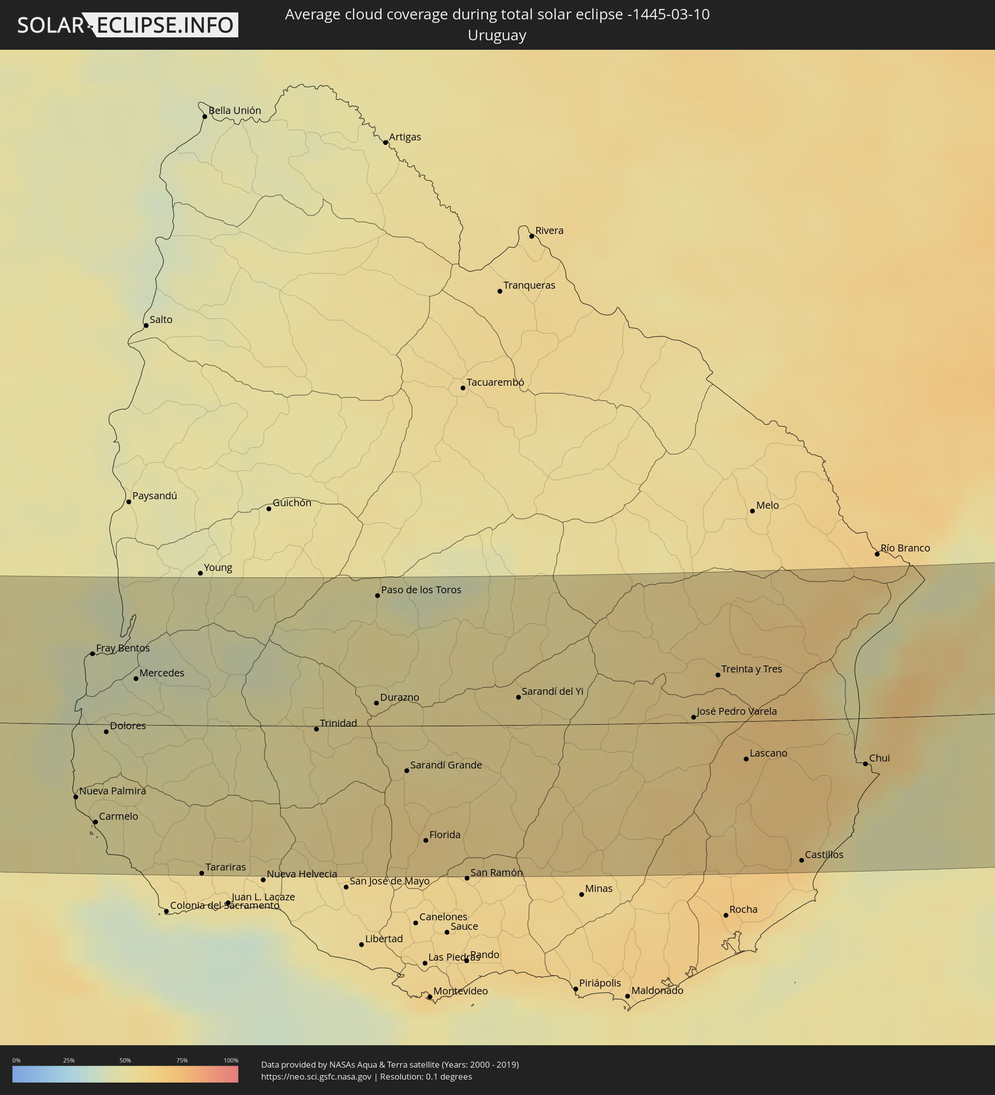 Uruguay
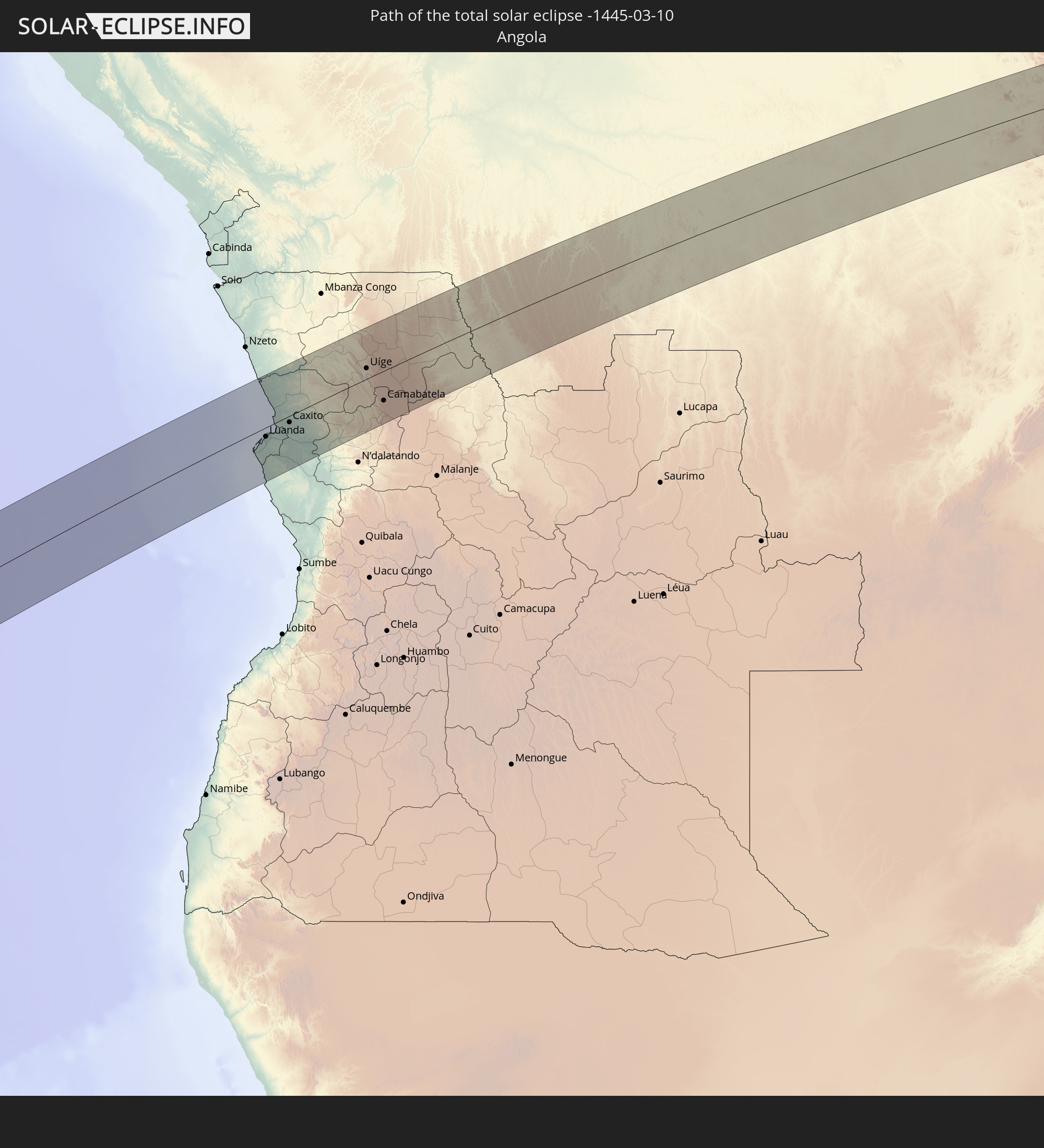
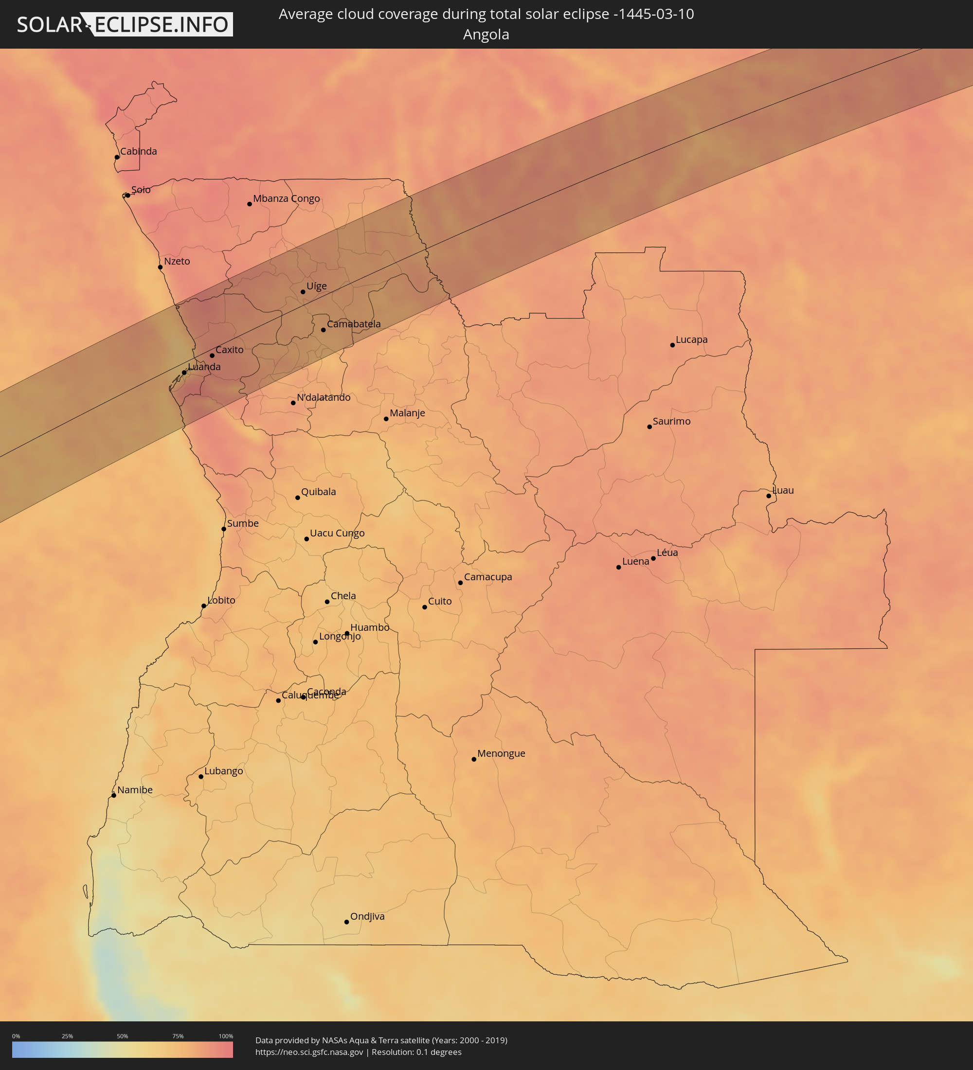 Angola
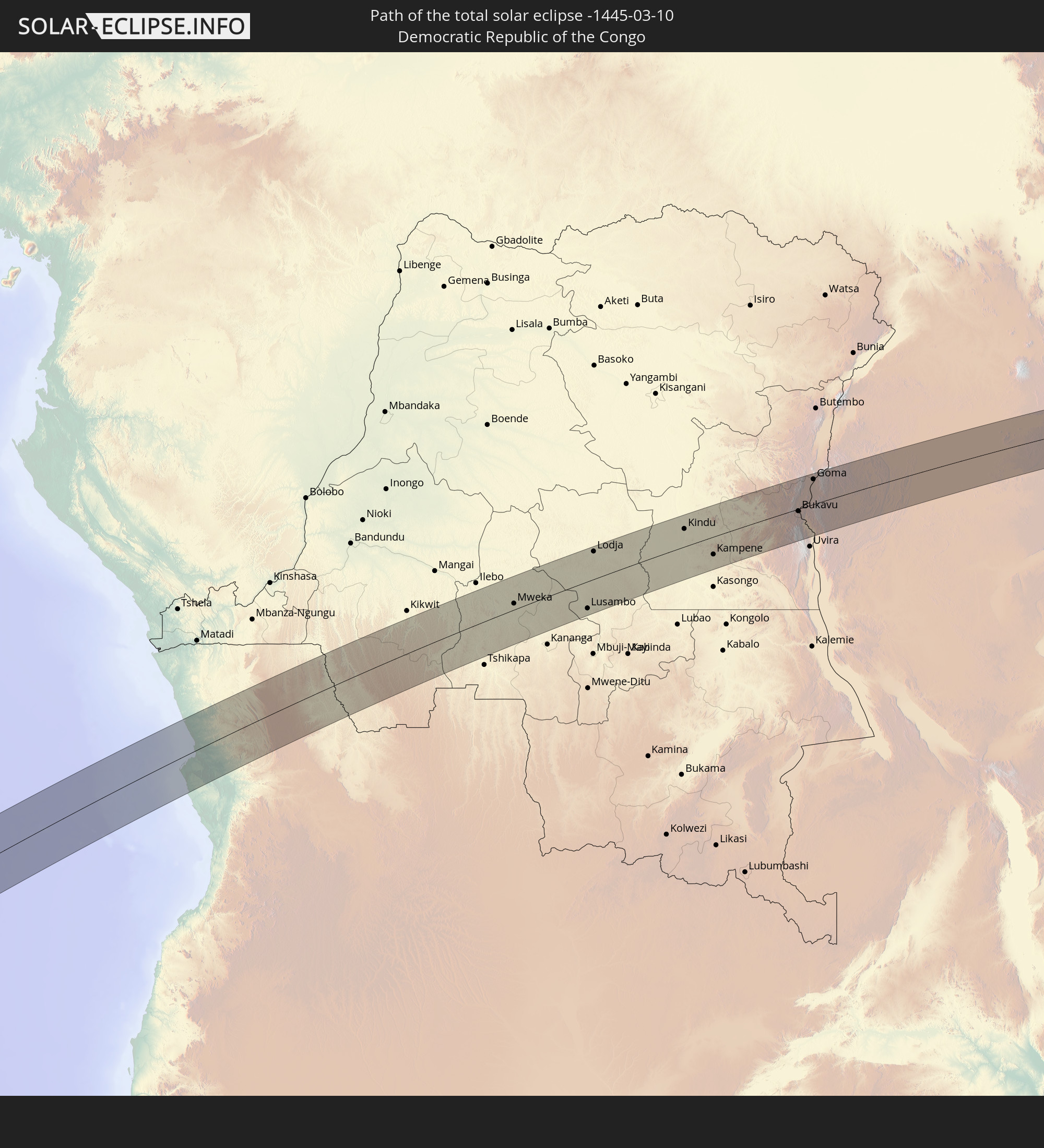
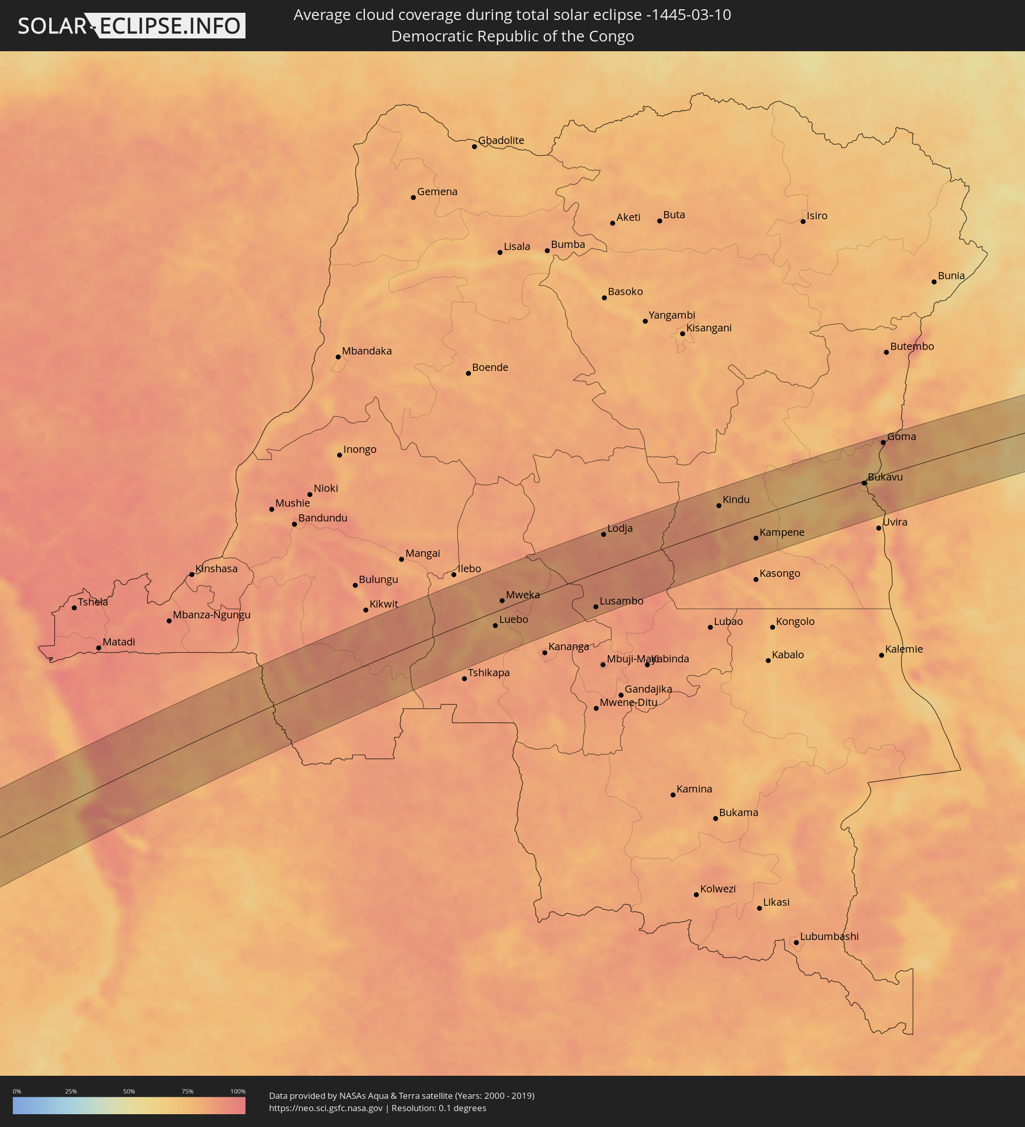 Democratic Republic of the Congo
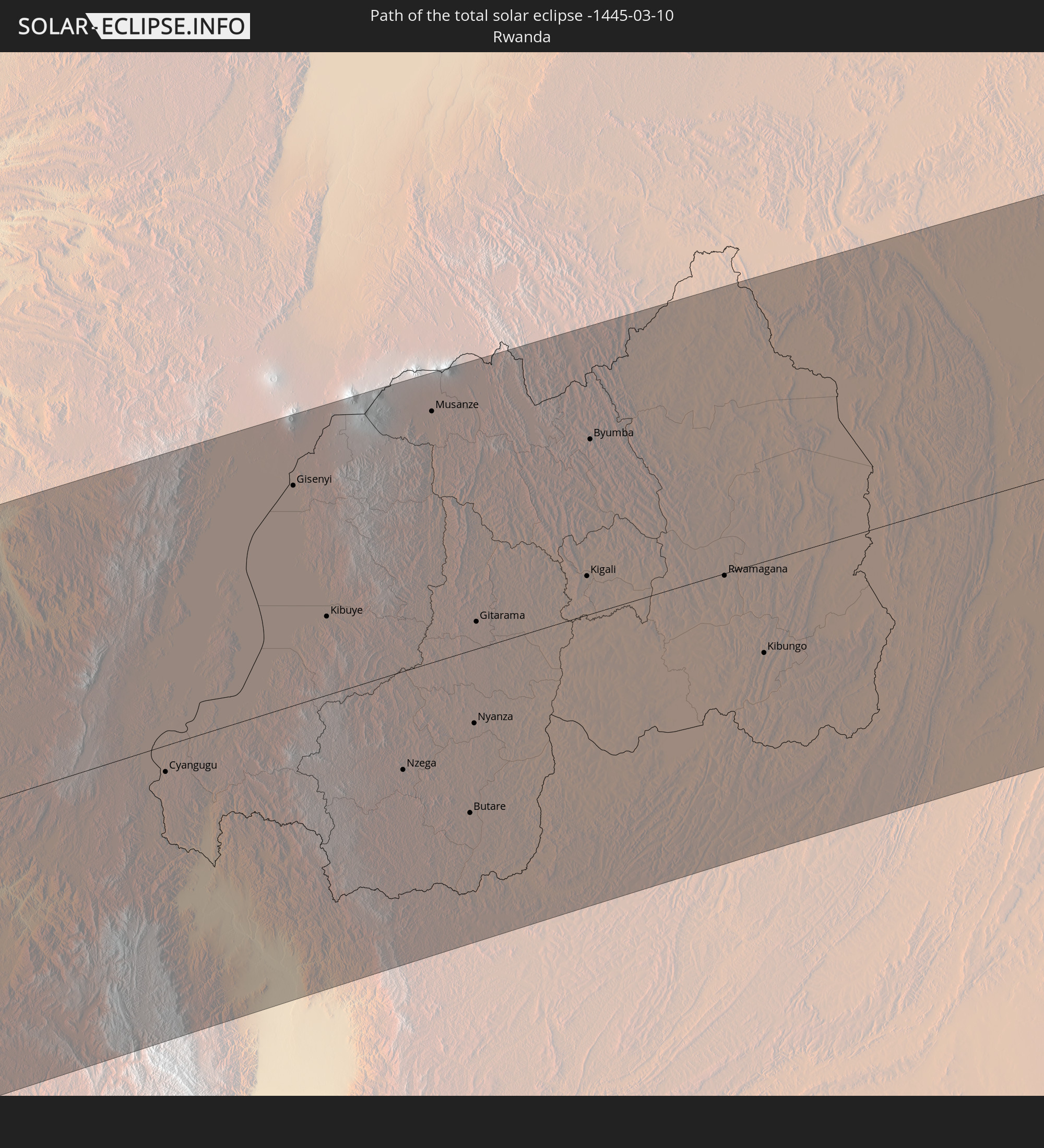
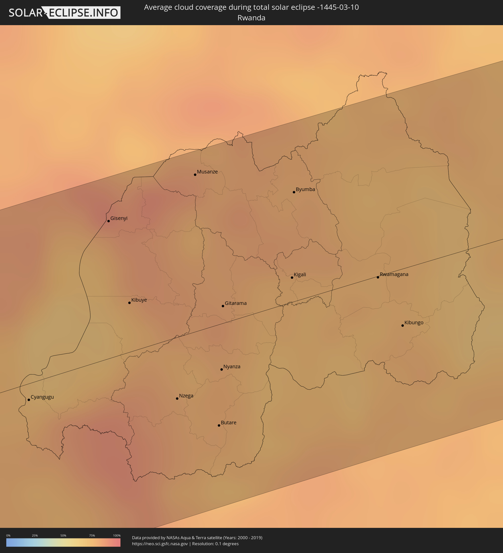 Rwanda
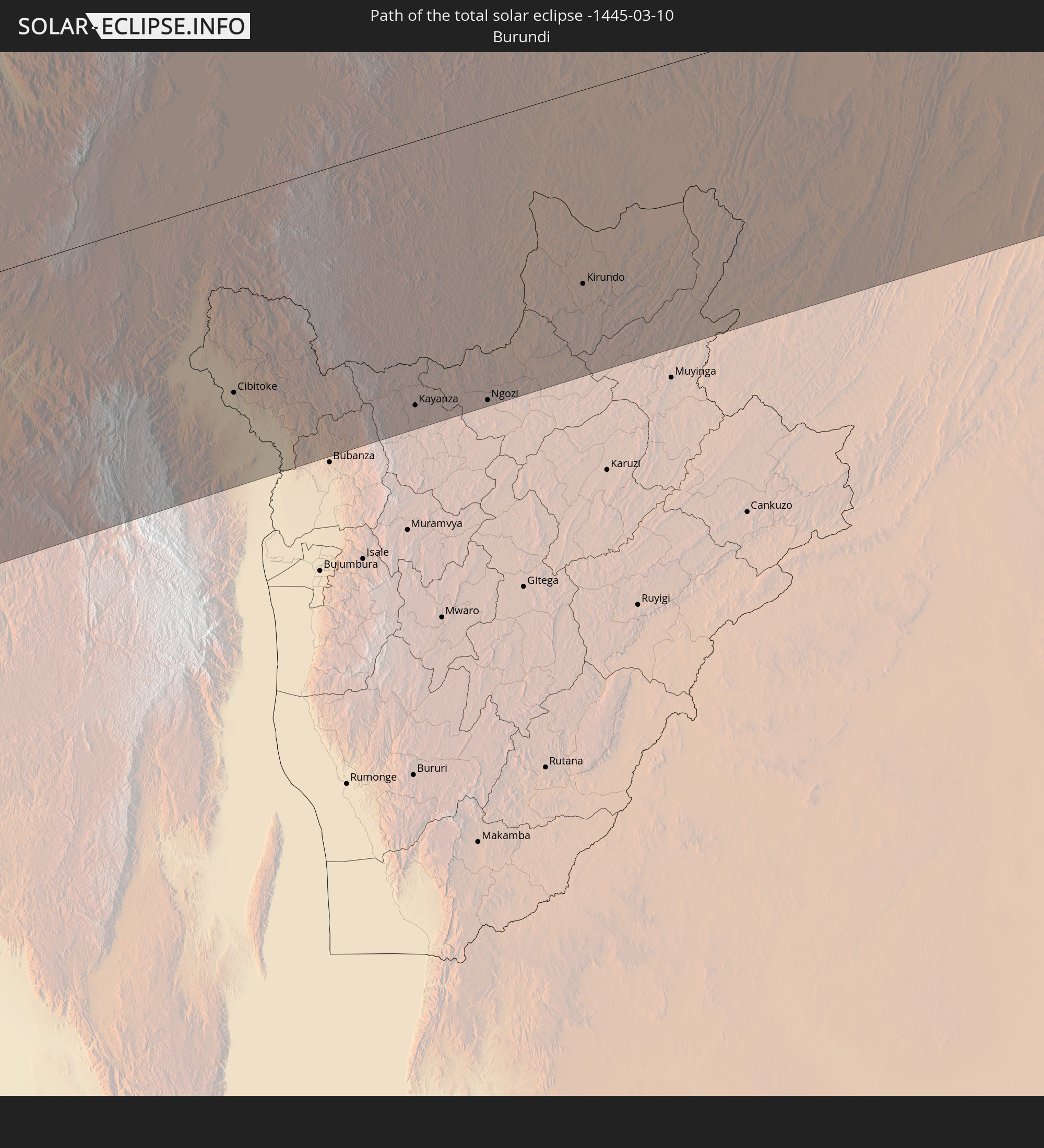
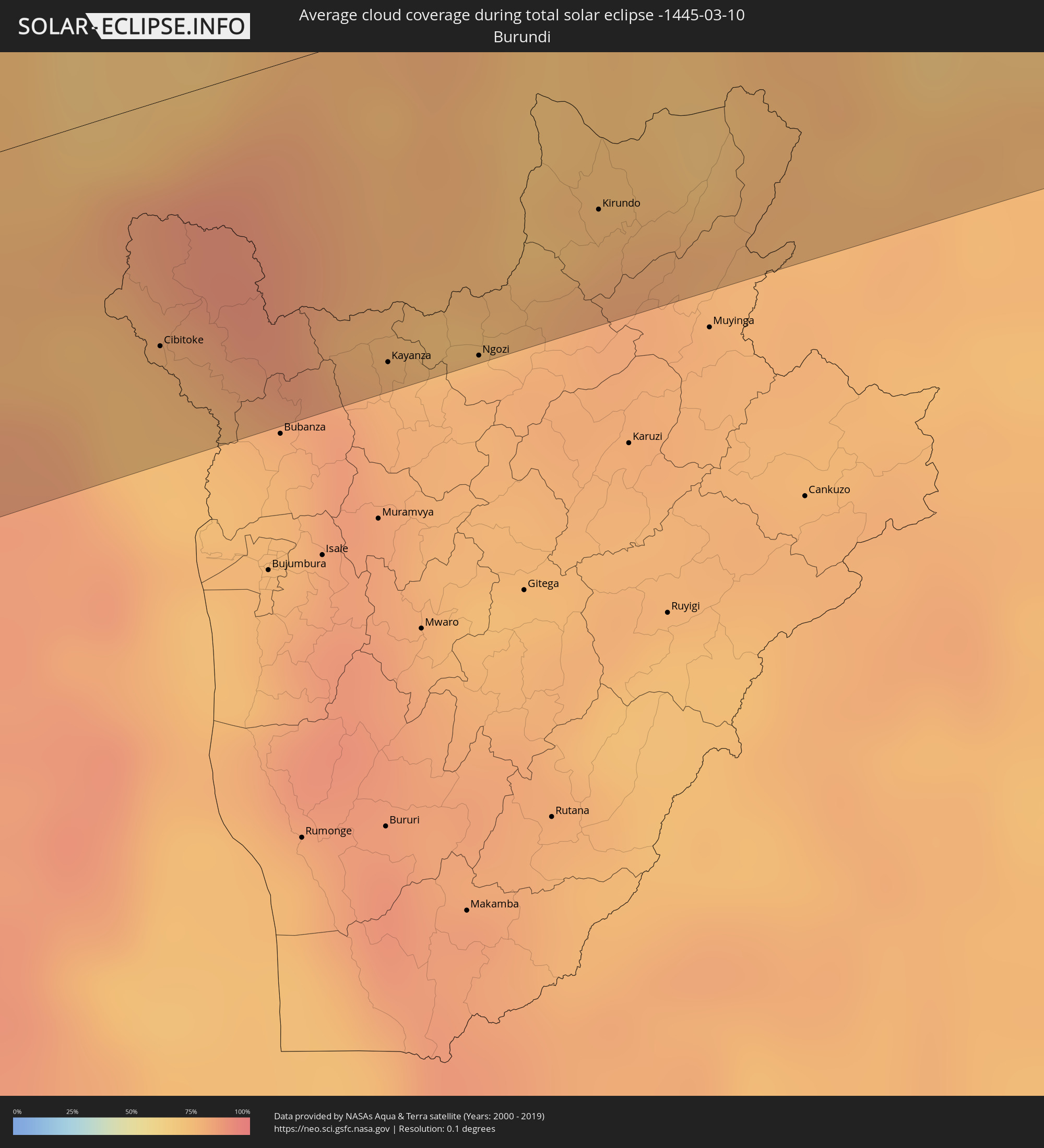 Burundi
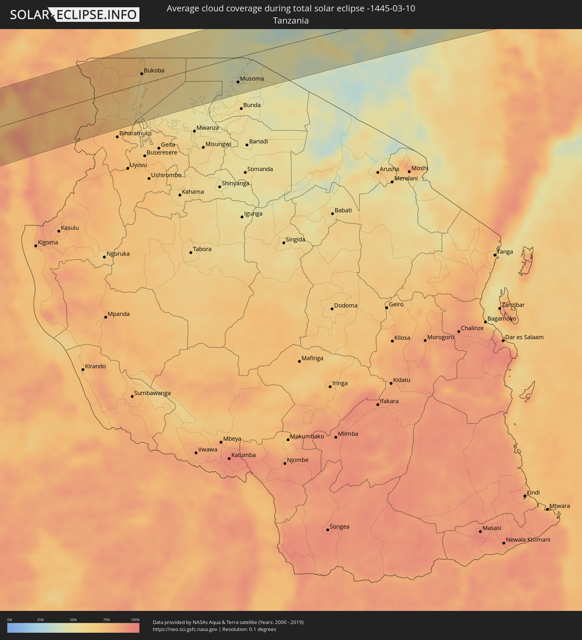 Tanzania
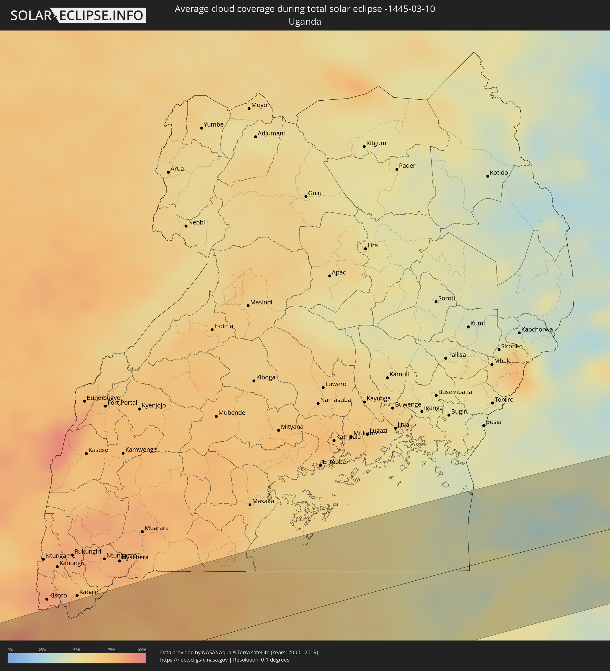 Uganda
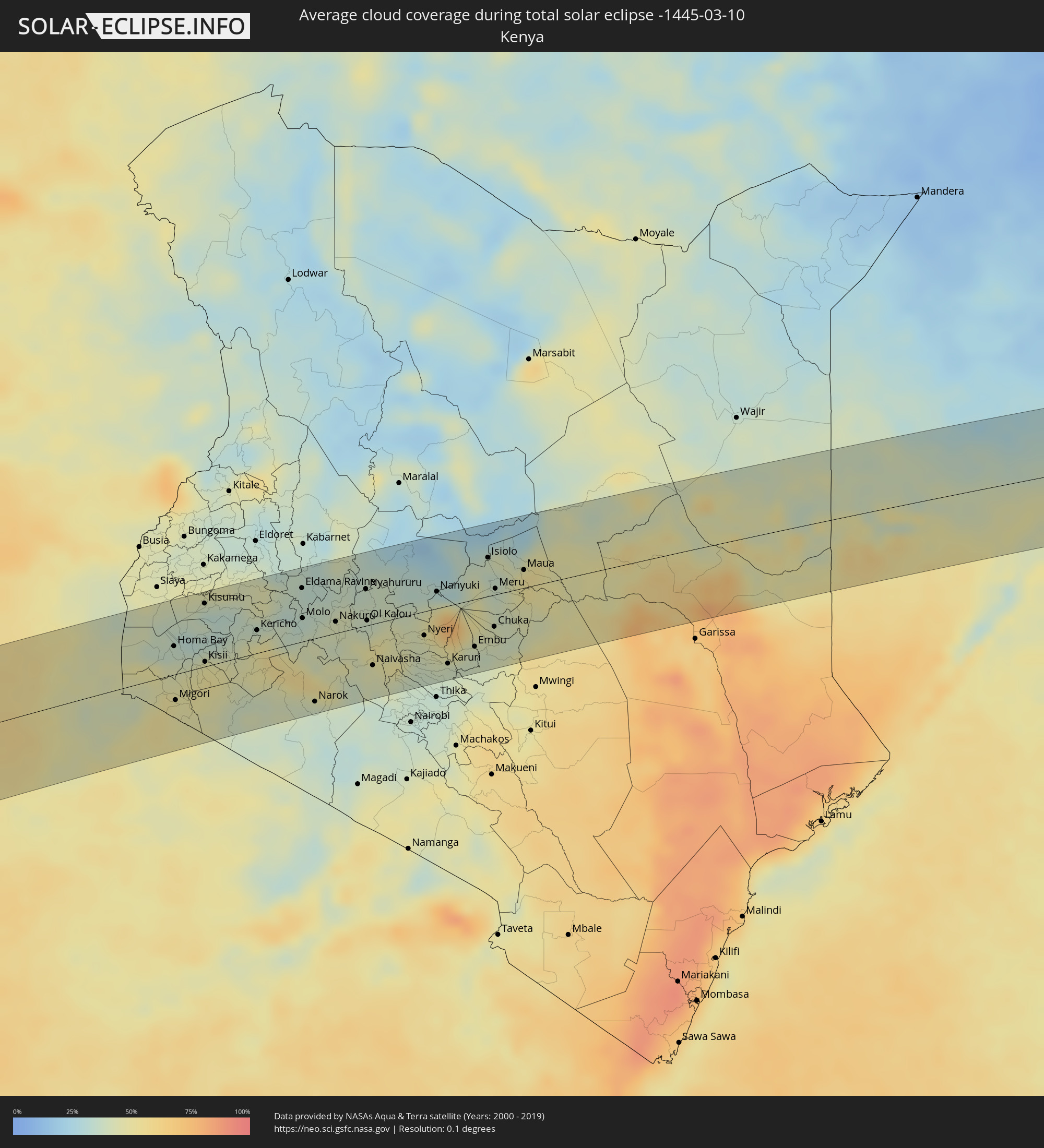 Kenya
Kenya
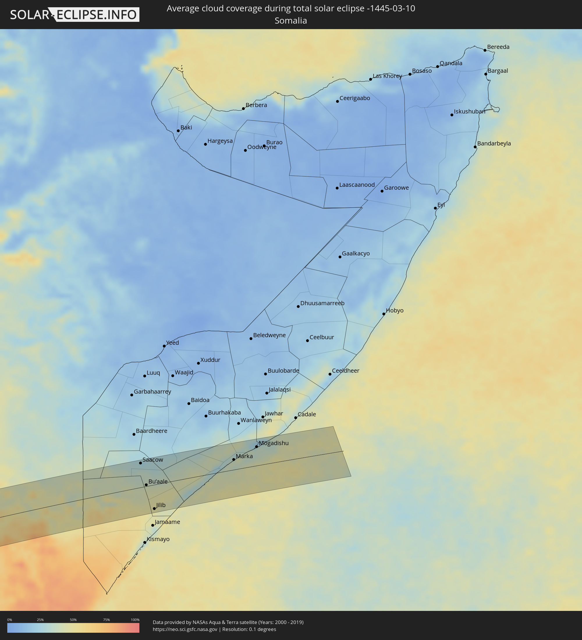 Somalia
Cities inside the path of the eclipse
The following table shows all locations with a population of more than 5,000 inside the eclipse path. Cities which have more than 100,000 inhabitants are marked bold. A click at the locations opens a detailed map.
| City | Type | Eclipse duration | Local time of max. eclipse | Distance to central line | Ø Cloud coverage |
|
Valparaíso, Valparaíso
|
total | - | 07:04:19 UTC-04:42 | 31 km | 37% |
|
Viña del Mar, Valparaíso
|
total | - | 07:04:20 UTC-04:42 | 28 km | 37% |
|
Quilpué, Valparaíso
|
total | - | 07:04:24 UTC-04:42 | 30 km | 24% |
|
Villa Alemana, Valparaíso
|
total | - | 07:04:25 UTC-04:42 | 29 km | 24% |
|
Limache, Valparaíso
|
total | - | 07:04:27 UTC-04:42 | 25 km | 25% |
|
Quillota, Valparaíso
|
total | - | 07:04:22 UTC-04:42 | 10 km | 23% |
|
La Ligua, Valparaíso
|
total | - | 07:04:07 UTC-04:42 | 38 km | 19% |
|
Hacienda La Calera, Valparaíso
|
total | - | 07:04:19 UTC-04:42 | 2 km | 21% |
|
Llaillay, Valparaíso
|
total | - | 07:04:27 UTC-04:42 | 2 km | 12% |
|
Lampa, Santiago Metropolitan
|
total | - | 07:04:46 UTC-04:42 | 51 km | 11% |
|
San Felipe, Valparaíso
|
total | - | 07:04:30 UTC-04:42 | 10 km | 10% |
|
Lo Prado, Santiago Metropolitan
|
total | - | 07:04:55 UTC-04:42 | 67 km | 12% |
|
Chicureo Abajo, Santiago Metropolitan
|
total | - | 07:04:51 UTC-04:42 | 48 km | 11% |
|
Santiago, Santiago Metropolitan
|
total | - | 07:04:58 UTC-04:42 | 67 km | 12% |
|
La Pintana, Santiago Metropolitan
|
total | - | 07:05:03 UTC-04:42 | 81 km | 13% |
|
Los Andes, Valparaíso
|
total | - | 07:04:36 UTC-04:42 | 2 km | 10% |
|
Villa Presidente Frei, Ñuñoa, Santiago, Chile, Santiago Metropolitan
|
total | - | 07:04:59 UTC-04:42 | 67 km | 12% |
|
Mendoza, Mendoza Province
|
total | - | 07:31:23 UTC-04:16 | 12 km | 38% |
|
San Martín, Mendoza Province
|
total | - | 07:31:40 UTC-04:16 | 6 km | 34% |
|
San Luis, San Luis Province
|
total | - | 07:32:54 UTC-04:16 | 13 km | 46% |
|
Villa Mercedes, San Luis Province
|
total | - | 07:33:38 UTC-04:16 | 49 km | 43% |
|
Río Cuarto, Cordoba Province
|
total | - | 07:34:00 UTC-04:16 | 18 km | 50% |
|
Bell Ville, Cordoba Province
|
total | - | 07:34:49 UTC-04:16 | 83 km | 53% |
|
Marcos Juárez, Cordoba Province
|
total | - | 07:35:16 UTC-04:16 | 78 km | 50% |
|
Venado Tuerto, Santa Fe Province
|
total | - | 07:35:57 UTC-04:16 | 38 km | 44% |
|
Cañada de Gómez, Santa Fe Province
|
total | - | 07:35:52 UTC-04:16 | 67 km | 50% |
|
Casilda, Santa Fe Province
|
total | - | 07:36:09 UTC-04:16 | 43 km | 50% |
|
Capitán Bermúdez, Santa Fe Province
|
total | - | 07:36:23 UTC-04:16 | 69 km | 50% |
|
Rosario, Santa Fe Province
|
total | - | 07:36:30 UTC-04:16 | 55 km | 47% |
|
Pergamino, Buenos Aires
|
total | - | 07:37:04 UTC-04:16 | 50 km | 50% |
|
Arroyo Seco, Santa Fe Province
|
total | - | 07:36:43 UTC-04:16 | 32 km | 47% |
|
Villa Constitución, Santa Fe Province
|
total | - | 07:36:54 UTC-04:16 | 25 km | 49% |
|
San Nicolás de los Arroyos, Buenos Aires
|
total | - | 07:37:02 UTC-04:16 | 13 km | 49% |
|
Gualeguay, Entre Ríos Province
|
total | - | 07:37:41 UTC-04:16 | 37 km | 48% |
|
Zárate, Buenos Aires
|
total | - | 07:38:25 UTC-04:16 | 69 km | 52% |
|
Gualeguaychú, Entre Ríos Province
|
total | - | 07:38:17 UTC-04:16 | 53 km | 44% |
|
Nueva Palmira, Colonia
|
total | - | 08:10:46 UTC-03:44 | 43 km | 50% |
|
Fray Bentos, Río Negro
|
total | - | 08:10:28 UTC-03:44 | 41 km | 43% |
|
Carmelo, Colonia
|
total | - | 08:10:57 UTC-03:44 | 57 km | 49% |
|
Dolores, Soriano
|
total | - | 08:10:45 UTC-03:44 | 5 km | 48% |
|
Mercedes, Soriano
|
total | - | 08:10:47 UTC-03:44 | 27 km | 46% |
|
Tarariras, Colonia
|
total | - | 08:11:40 UTC-03:44 | 86 km | 52% |
|
Trinidad, Flores
|
total | - | 08:11:56 UTC-03:44 | 2 km | 52% |
|
Trinidad, Flores
|
total | - | 08:11:57 UTC-03:44 | 5 km | 52% |
|
Durazno, Durazno
|
total | - | 08:12:13 UTC-03:44 | 13 km | 55% |
|
Paso de los Toros, Tacuarembó
|
total | - | 08:11:57 UTC-03:44 | 76 km | 49% |
|
Sarandí Grande, Florida
|
total | - | 08:12:34 UTC-03:44 | 26 km | 56% |
|
Florida, Florida
|
total | - | 08:12:51 UTC-03:44 | 67 km | 59% |
|
Sarandí del Yi, Durazno
|
total | - | 08:13:03 UTC-03:44 | 16 km | 55% |
|
José Pedro Varela, Lavalleja
|
total | - | 08:14:11 UTC-03:44 | 3 km | 60% |
|
Treinta y Tres, Treinta y Tres
|
total | - | 08:14:15 UTC-03:44 | 27 km | 62% |
|
Lascano, Rocha
|
total | - | 08:14:37 UTC-03:44 | 22 km | 62% |
|
Castillos, Rocha
|
total | - | 08:15:13 UTC-03:44 | 82 km | 59% |
|
Chui, Rocha
|
total | - | 08:15:25 UTC-03:44 | 27 km | 62% |
|
Chuí, Rio Grande do Sul
|
total | - | 08:15:25 UTC-03:44 | 26 km | 62% |
|
Santa Vitória do Palmar, Rio Grande do Sul
|
total | - | 08:53:49 UTC-03:06 | 7 km | 61% |
|
Luanda, Luanda
|
total | - | 14:49:48 UTC+00:13 | 16 km | 86% |
|
Caxito, Bengo
|
total | - | 14:50:42 UTC+00:13 | 12 km | 89% |
|
Uíge, Uíge
|
total | - | 14:53:42 UTC+00:13 | 19 km | 81% |
|
Camabatela, Cuanza Norte
|
total | - | 14:53:19 UTC+00:13 | 54 km | 76% |
|
Kasongo-Lunda, Bandundu
|
total | - | 14:57:07 UTC+00:13 | 53 km | 79% |
|
Luebo, Kasaï-Occidental
|
total | - | 16:59:45 UTC+02:10 | 30 km | 82% |
|
Mweka, Kasaï-Occidental
|
total | - | 17:00:25 UTC+02:10 | 16 km | 83% |
|
Demba, Kasaï-Occidental
|
total | - | 17:00:20 UTC+02:10 | 79 km | 83% |
|
Lusambo, Kasaï-Oriental
|
total | - | 17:01:52 UTC+02:10 | 72 km | 84% |
|
Lodja, Kasaï-Oriental
|
total | - | 17:03:29 UTC+02:10 | 74 km | 83% |
|
Kindu, Maniema
|
total | - | 17:05:43 UTC+02:10 | 48 km | 79% |
|
Kampene, Maniema
|
total | - | 17:05:35 UTC+02:10 | 48 km | 77% |
|
Kabare, South Kivu
|
total | - | 17:07:53 UTC+02:10 | 5 km | 77% |
|
Bukavu, South Kivu
|
total | - | 17:07:55 UTC+02:10 | 6 km | 77% |
|
Cyangugu, Western Province
|
total | - | 17:07:57 UTC+02:10 | 8 km | 79% |
|
Sake, Nord Kivu
|
total | - | 17:08:50 UTC+02:10 | 85 km | 77% |
|
Cibitoke, Cibitoke
|
total | - | 17:07:43 UTC+02:10 | 58 km | 75% |
|
Goma, Nord Kivu
|
total | - | 17:08:51 UTC+02:10 | 68 km | 75% |
|
Gisenyi, Western Province
|
total | - | 17:08:50 UTC+02:10 | 64 km | 82% |
|
Kibuye, Western Province
|
total | - | 17:08:34 UTC+02:10 | 23 km | 74% |
|
Nzega, Southern Province
|
total | - | 17:08:18 UTC+02:10 | 29 km | 78% |
|
Kayanza, Kayanza
|
total | - | 17:07:57 UTC+02:10 | 78 km | 80% |
|
Musanze, Northern Province
|
total | - | 17:09:12 UTC+02:10 | 73 km | 78% |
|
Butare, Southern Province
|
total | - | 17:08:18 UTC+02:10 | 47 km | 75% |
|
Nyanza, Southern Province
|
total | - | 17:08:31 UTC+02:10 | 21 km | 77% |
|
Gitarama, Southern Province
|
total | - | 17:08:46 UTC+02:10 | 8 km | 78% |
|
Ngozi, Ngozi
|
total | - | 17:08:04 UTC+02:10 | 83 km | 77% |
|
Kigali, Kigali
|
total | - | 17:09:02 UTC+02:10 | 11 km | 74% |
|
Byumba, Northern Province
|
total | - | 17:09:21 UTC+02:10 | 51 km | 80% |
|
Kirundo, Kirundo
|
total | - | 17:08:29 UTC+02:10 | 57 km | 81% |
|
Rwamagana, Eastern Province
|
total | - | 17:09:13 UTC+02:10 | 1 km | 75% |
|
Kabanga, Kagera
|
total | - | 17:25:34 UTC+02:27 | 75 km | 78% |
|
Kibungo, Eastern Province
|
total | - | 17:09:05 UTC+02:10 | 27 km | 76% |
|
Ngara, Kagera
|
total | - | 17:25:46 UTC+02:27 | 68 km | 78% |
|
Bugene, Kagera
|
total | - | 17:26:47 UTC+02:27 | 15 km | 72% |
|
Nyakahanga, Kagera
|
total | - | 17:26:46 UTC+02:27 | 14 km | 72% |
|
Nsunga, Kagera
|
total | - | 17:27:16 UTC+02:27 | 55 km | 75% |
|
Kyaka, Kagera
|
total | - | 17:27:11 UTC+02:27 | 43 km | 74% |
|
Katoro, Kagera
|
total | - | 17:27:06 UTC+02:27 | 24 km | 69% |
|
Nshamba, Kagera
|
total | - | 17:26:47 UTC+02:27 | 20 km | 63% |
|
Kamachumu, Kagera
|
total | - | 17:26:58 UTC+02:27 | 3 km | 63% |
|
Muleba, Kagera
|
total | - | 17:26:48 UTC+02:27 | 27 km | 60% |
|
Katerero, Kagera
|
total | - | 17:27:12 UTC+02:27 | 17 km | 62% |
|
Bukoba, Kagera
|
total | - | 17:27:18 UTC+02:27 | 22 km | 63% |
|
Muriti, Mara
|
total | - | 17:27:13 UTC+02:27 | 81 km | 47% |
|
Mugango, Mara
|
total | - | 17:27:45 UTC+02:27 | 72 km | 50% |
|
Musoma, Mara
|
total | - | 17:27:56 UTC+02:27 | 55 km | 46% |
|
Tarime, Mara
|
total | - | 17:28:15 UTC+02:27 | 56 km | 51% |
|
Homa Bay, Homa Bay
|
total | - | 17:28:55 UTC+02:27 | 30 km | 37% |
|
Migori, Migori
|
total | - | 17:28:31 UTC+02:27 | 28 km | 47% |
|
Sirari, Mara
|
total | - | 17:28:22 UTC+02:27 | 48 km | 48% |
|
Kisumu, Kisumu
|
total | - | 17:29:20 UTC+02:27 | 68 km | 33% |
|
Kisii, Kisii
|
total | - | 17:28:54 UTC+02:27 | 5 km | 51% |
|
Kericho, Kericho
|
total | - | 17:29:18 UTC+02:27 | 25 km | 48% |
|
Molo, Nakuru
|
total | - | 17:29:31 UTC+02:27 | 25 km | 34% |
|
Narok, Narok
|
total | - | 17:28:56 UTC+02:27 | 68 km | 36% |
|
Rongai, Nakuru
|
total | - | 17:29:36 UTC+02:27 | 30 km | 38% |
|
Nakuru, Nakuru
|
total | - | 17:29:35 UTC+02:27 | 12 km | 42% |
|
Nyahururu, Laikipia
|
total | - | 17:29:54 UTC+02:27 | 40 km | 38% |
|
Ol Kalou, Nyandarua
|
total | - | 17:29:40 UTC+02:27 | 5 km | 41% |
|
Naivasha, Nakuru
|
total | - | 17:29:22 UTC+02:27 | 44 km | 44% |
|
Nyeri, Nyeri
|
total | - | 17:29:42 UTC+02:27 | 26 km | 42% |
|
Nanyuki, Laikipia
|
total | - | 17:30:03 UTC+02:27 | 18 km | 45% |
|
Karuri, Murang'A
|
total | - | 17:29:33 UTC+02:27 | 62 km | 38% |
|
Keruguya, Kirinyaga
|
total | - | 17:29:44 UTC+02:27 | 43 km | 46% |
|
Embu, Embu
|
total | - | 17:29:45 UTC+02:27 | 51 km | 39% |
|
Isiolo, Isiolo
|
total | - | 17:30:24 UTC+02:27 | 42 km | 36% |
|
Meru, Meru
|
total | - | 17:30:12 UTC+02:27 | 6 km | 39% |
|
Saacow, Middle Juba
|
total | - | 17:31:52 UTC+02:27 | 66 km | 29% |
|
Bu’aale, Middle Juba
|
total | - | 17:31:33 UTC+02:27 | 3 km | 41% |
|
Jilib, Middle Juba
|
total | - | 17:31:11 UTC+02:27 | 66 km | 47% |
|
Qoryooley, Lower Shabeelle
|
total | - | 17:32:01 UTC+02:27 | 40 km | 35% |
|
Marka, Lower Shabeelle
|
total | - | 17:31:58 UTC+02:27 | 27 km | 38% |
|
Afgooye, Lower Shabeelle
|
total | - | 17:32:12 UTC+02:27 | 67 km | 33% |
|
Mogadishu, Banaadir
|
total | - | 17:32:08 UTC+02:27 | 51 km | 35% |