Total solar eclipse of 02/08/-1453
| Day of week: | Monday |
| Maximum duration of eclipse: | 04m07s |
| Maximum width of eclipse path: | 183 km |
| Saros cycle: | 17 |
| Coverage: | 100% |
| Magnitude: | 1.0523 |
| Gamma: | -0.3204 |
Wo kann man die Sonnenfinsternis vom 02/08/-1453 sehen?
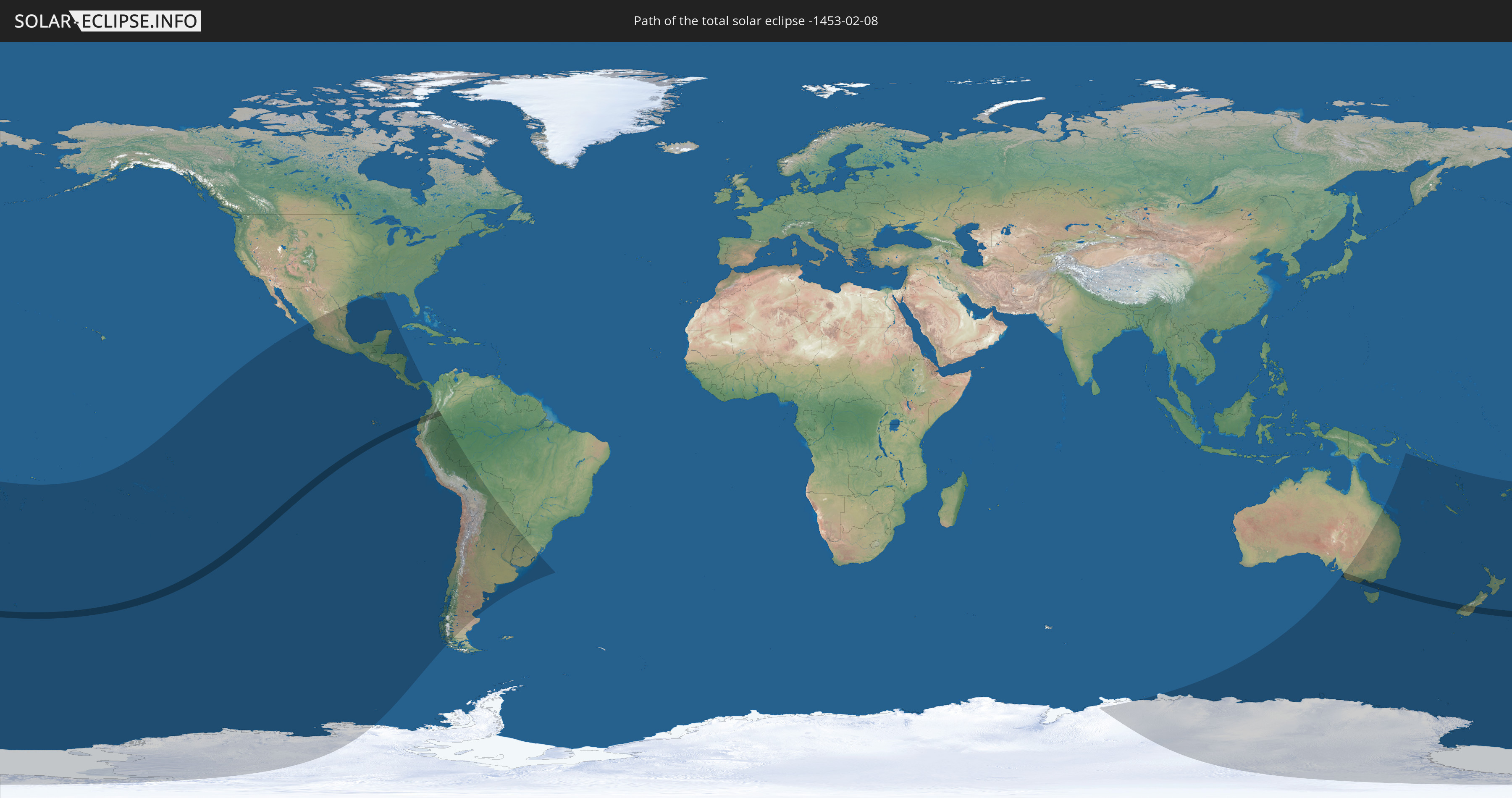
Die Sonnenfinsternis am 02/08/-1453 kann man in 33 Ländern als partielle Sonnenfinsternis beobachten.
Der Finsternispfad verläuft durch 4 Länder. Nur in diesen Ländern ist sie als total Sonnenfinsternis zu sehen.
In den folgenden Ländern ist die Sonnenfinsternis total zu sehen
 New Zealand
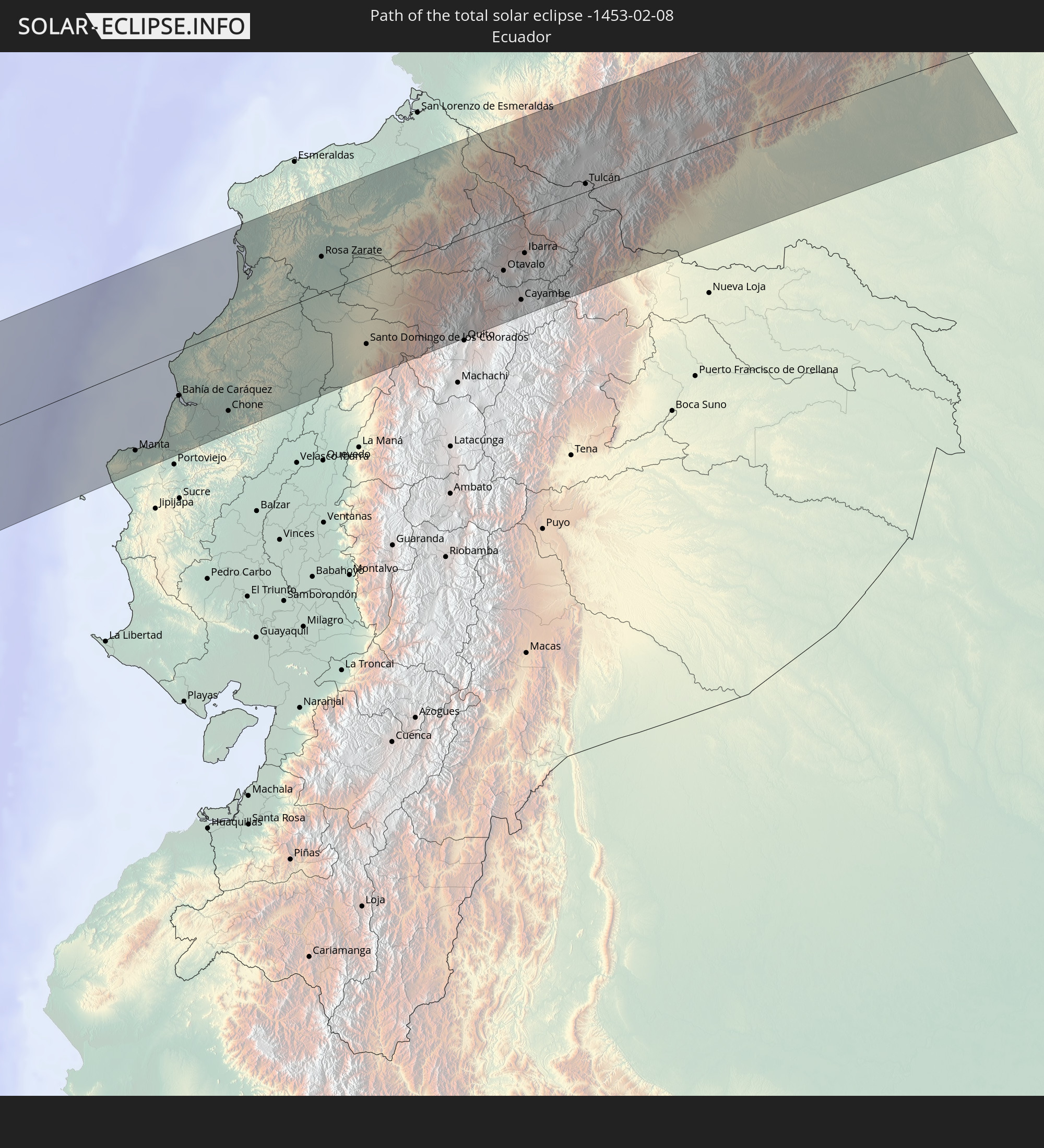 Ecuador
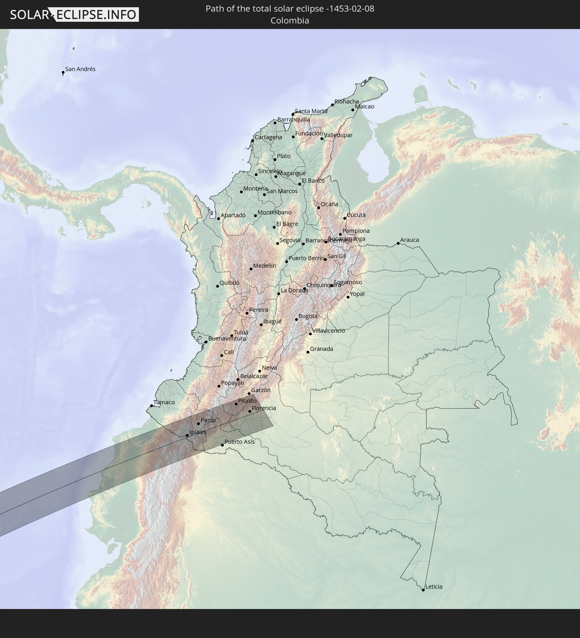 Colombia
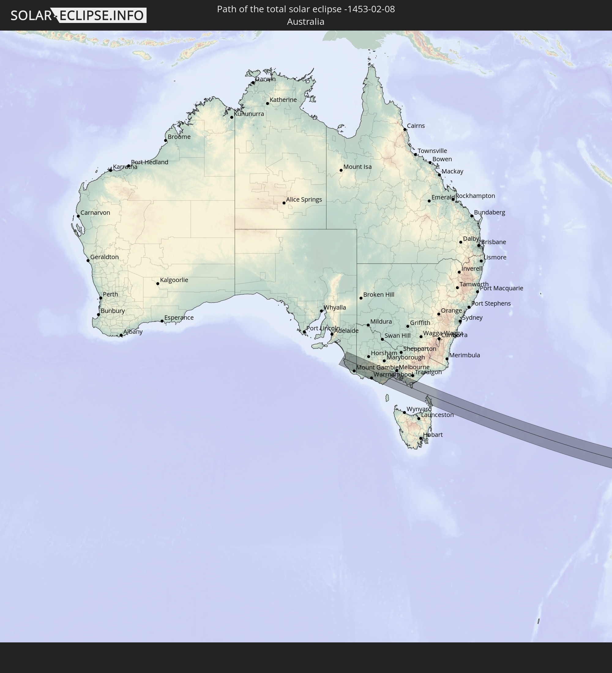 Australia
In den folgenden Ländern ist die Sonnenfinsternis partiell zu sehen
 Antarctica
 Fiji
Fiji
 United States
 New Zealand
 Tonga
Tonga
 Kiribati
 Niue
Niue
 Cook Islands
 French Polynesia
 Pitcairn Islands
 Mexico
 Chile
Chile
 Guatemala
 Ecuador
 El Salvador
 Honduras
 Belize
 Nicaragua
 Costa Rica
 Panama
 Colombia
 Peru
Peru
 Brazil
 Argentina
 Bolivia
 Paraguay
 Uruguay
 Australia
 Papua New Guinea
 Solomon Islands
 New Caledonia
 Vanuatu
 Norfolk Island
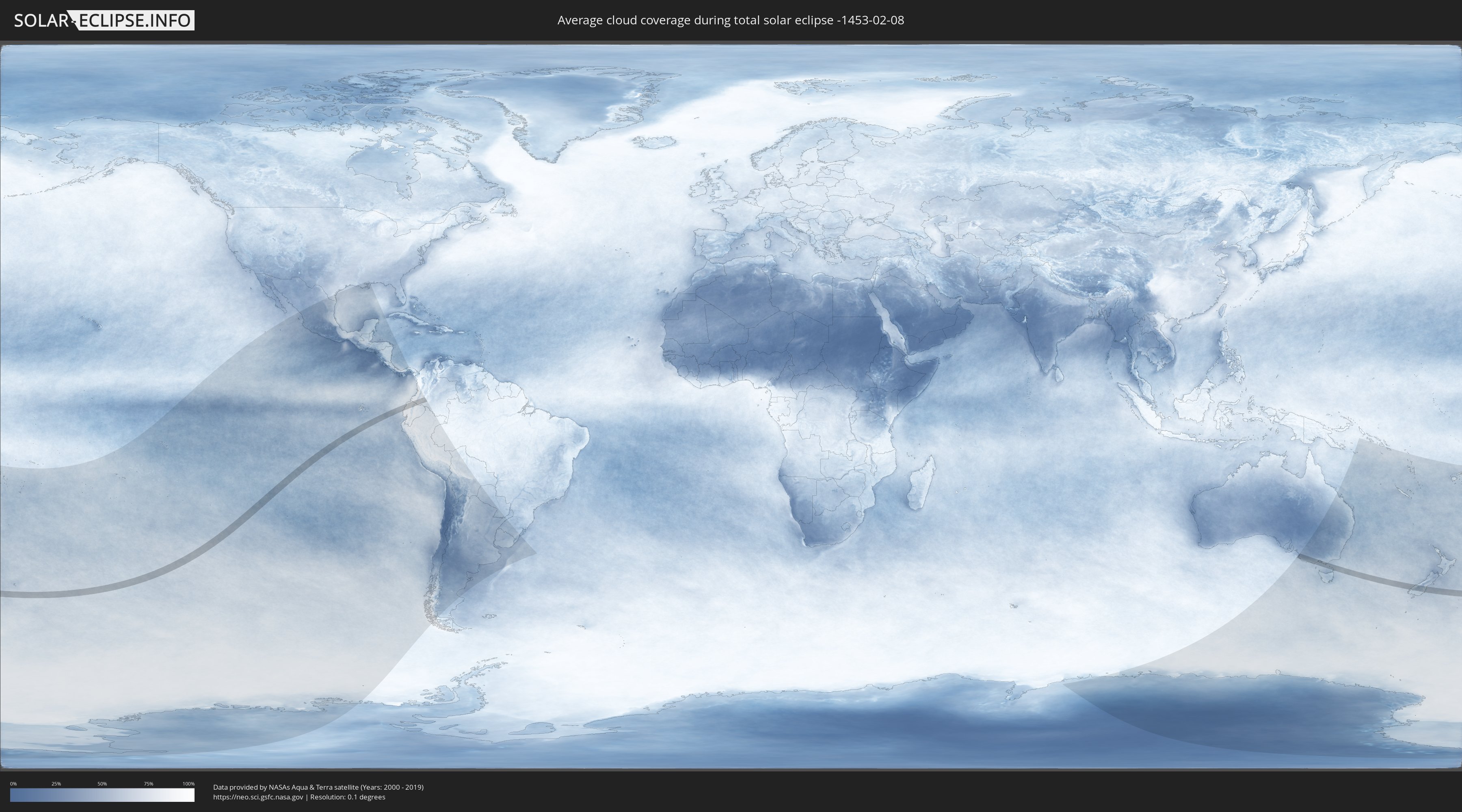
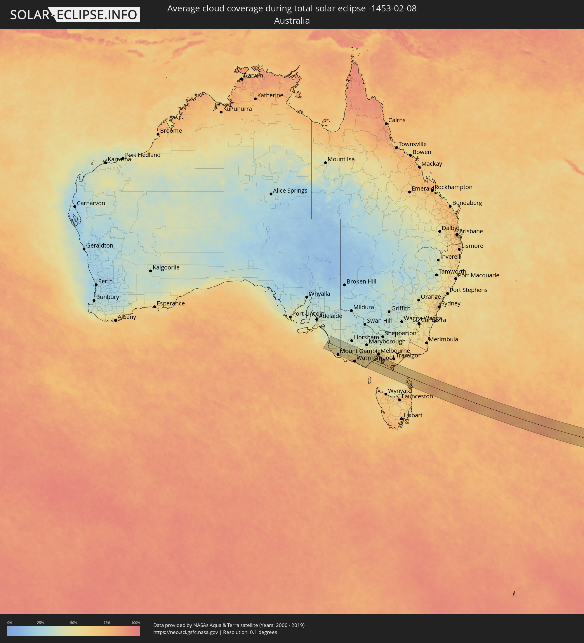
How will be the weather during the total solar eclipse on 02/08/-1453?
Where is the best place to see the total solar eclipse of 02/08/-1453?
The following maps show the average cloud coverage for the day of the total solar eclipse.
With the help of these maps, it is possible to find the place along the eclipse path, which has the best
chance of a cloudless sky.
Nevertheless, you should consider local circumstances and inform about the weather of your chosen
observation site.
The data is provided by NASAs satellites
AQUA and TERRA.
The cloud maps are averaged over a period of 19 years (2000 - 2019).

Detailed country maps
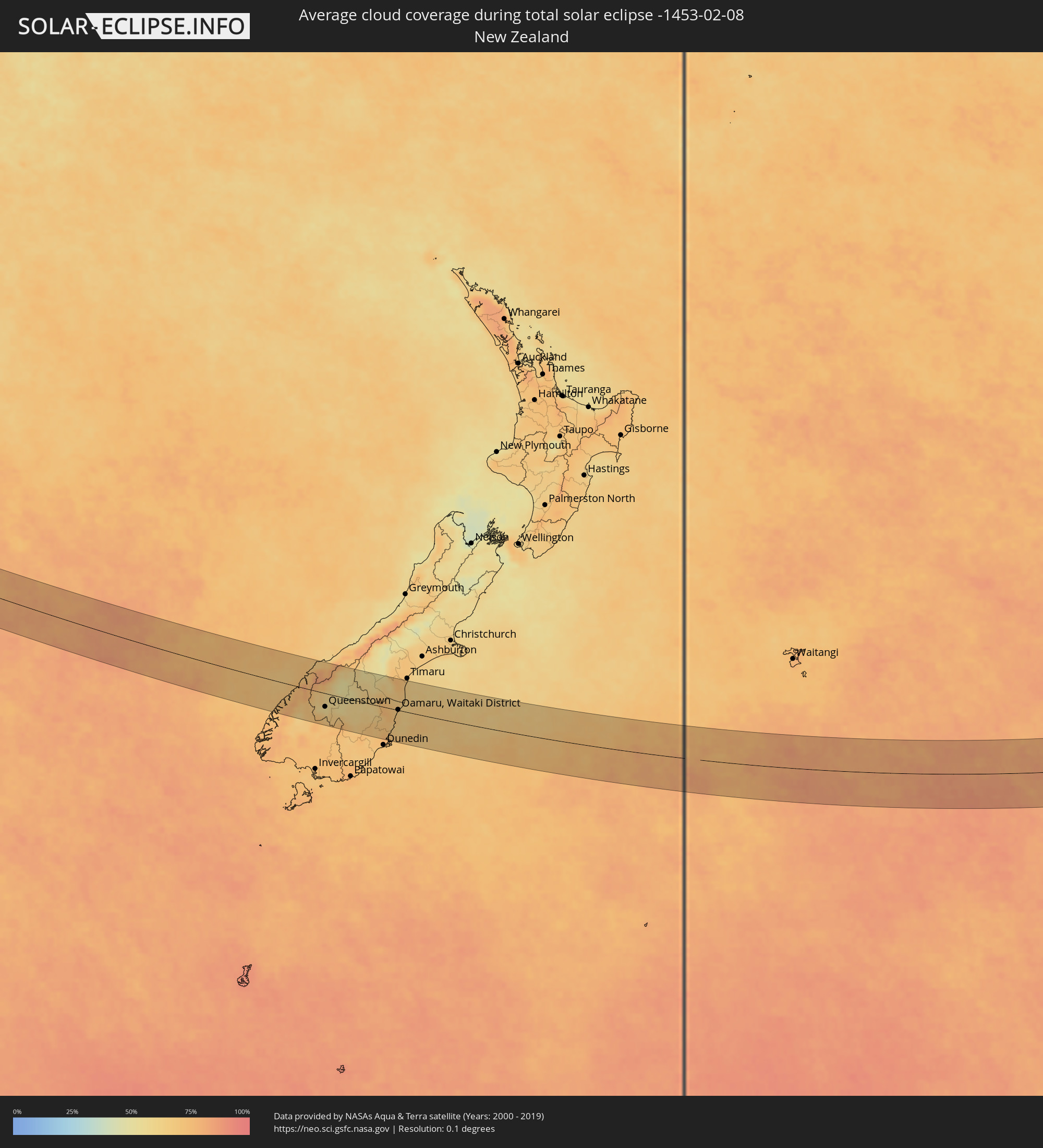 New Zealand
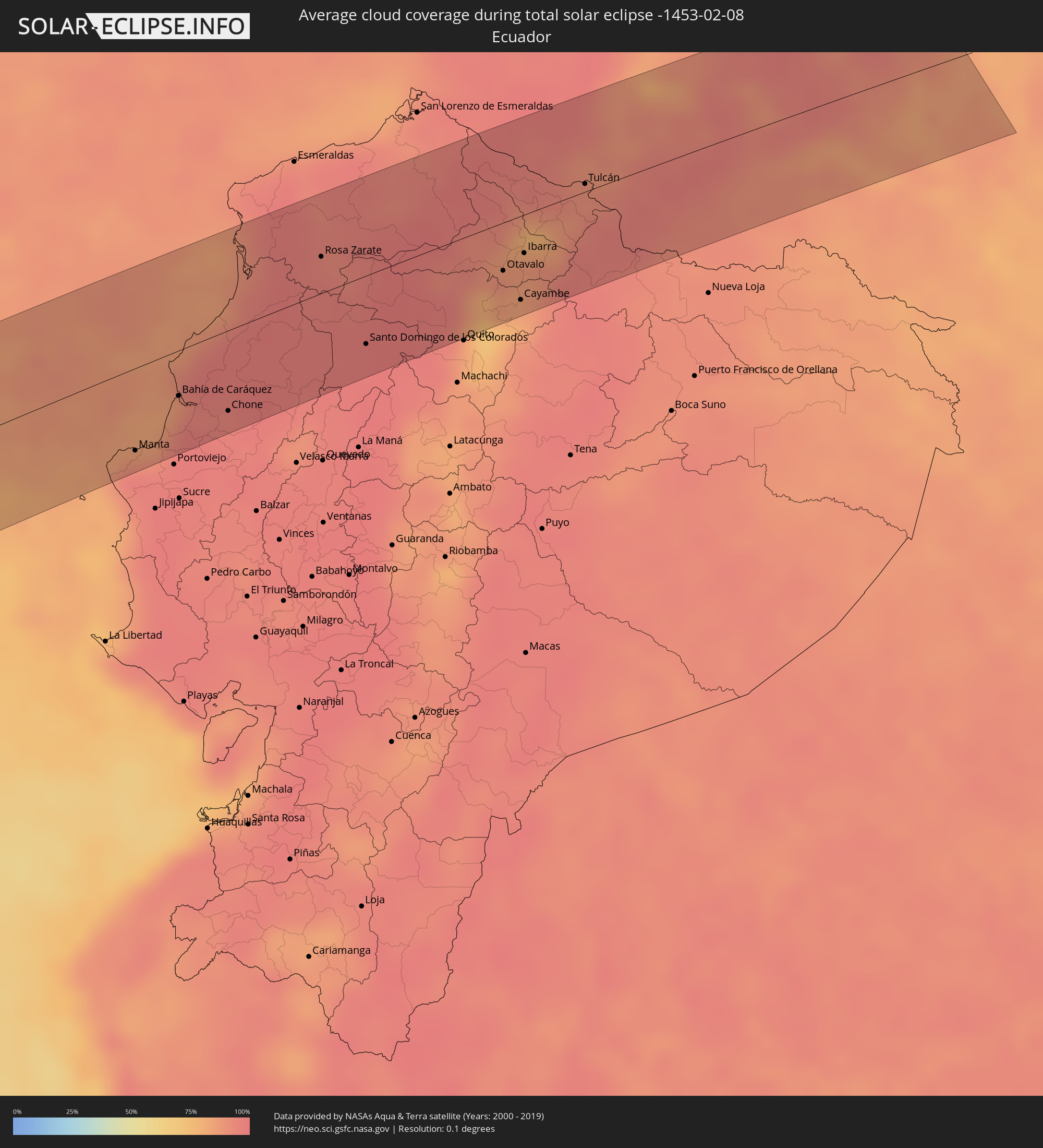 Ecuador
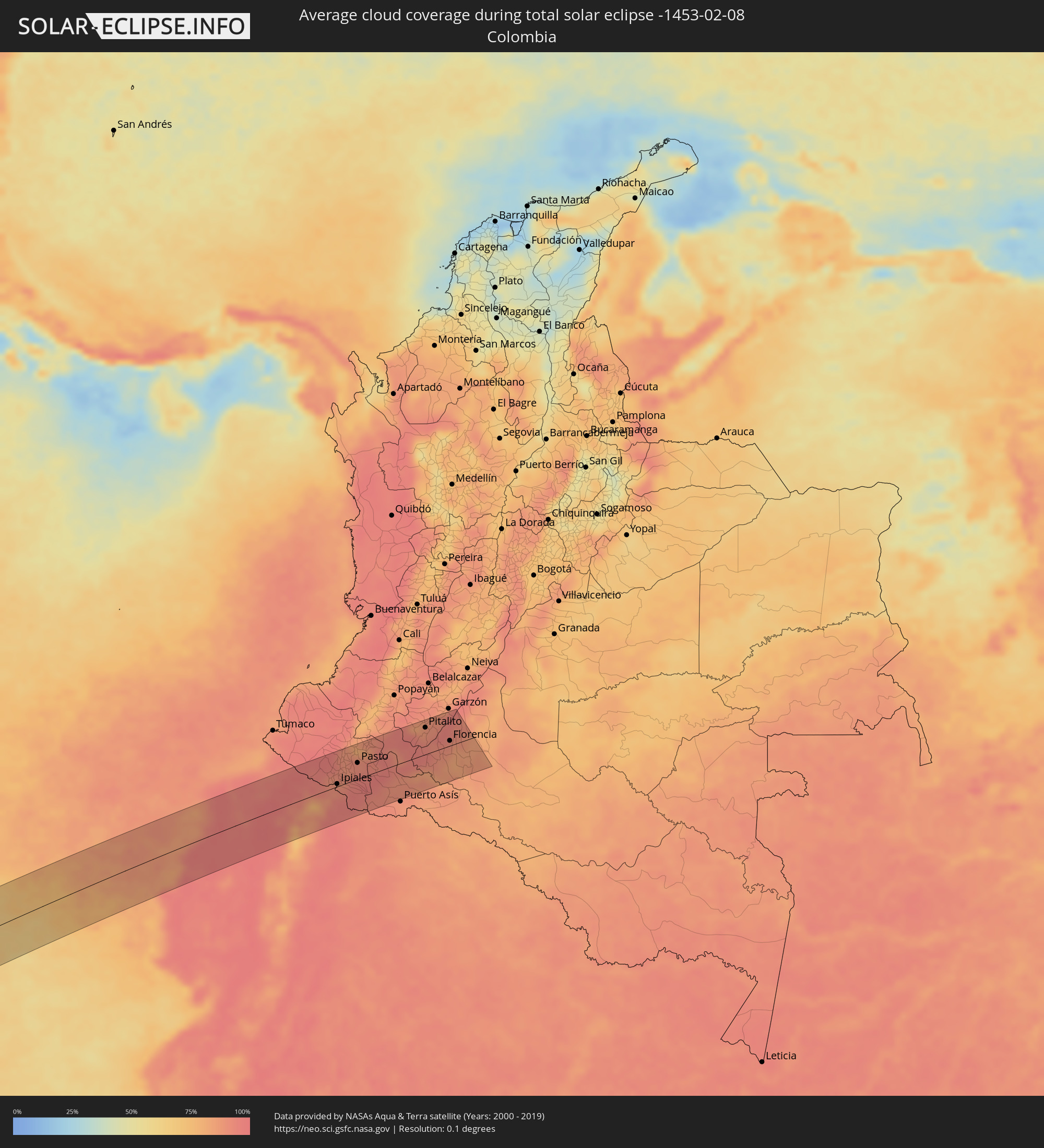 Colombia
 Australia
Cities inside the path of the eclipse
The following table shows all locations with a population of more than 5,000 inside the eclipse path. Cities which have more than 100,000 inhabitants are marked bold. A click at the locations opens a detailed map.
| City | Type | Eclipse duration | Local time of max. eclipse | Distance to central line | Ø Cloud coverage |
|
Manta, Manabí
|
total | - | 18:02:23 UTC-05:14 | 56 km | 97% |
|
Montecristi, Manabí
|
total | - | 18:02:19 UTC-05:14 | 67 km | 97% |
|
Rocafuerte, Manabí
|
total | - | 18:02:24 UTC-05:14 | 64 km | 97% |
|
Bahía de Caráquez, Manabí
|
total | - | 18:02:40 UTC-05:14 | 31 km | 94% |
|
Tosagua, Manabí
|
total | - | 18:02:29 UTC-05:14 | 59 km | 97% |
|
Calceta, Manabí
|
total | - | 18:02:26 UTC-05:14 | 68 km | 97% |
|
Chone, Manabí
|
total | - | 18:02:33 UTC-05:14 | 55 km | 96% |
|
Pedernales, Manabí
|
total | - | 18:03:10 UTC-05:14 | 22 km | 88% |
|
Rosa Zarate, Esmeraldas
|
total | - | 18:03:18 UTC-05:14 | 25 km | 94% |
|
Santo Domingo de los Colorados, Santo Domingo de los Tsáchilas
|
total | - | 18:02:47 UTC-05:14 | 47 km | 97% |
|
Tutamandahostel, Pichincha
|
total | - | 18:02:44 UTC-05:14 | 69 km | 81% |
|
Cotacachi, Imbabura
|
total | - | 18:03:05 UTC-05:14 | 26 km | 86% |
|
Otavalo, Imbabura
|
total | - | 18:03:02 UTC-05:14 | 33 km | 90% |
|
Atuntaqui, Imbabura
|
total | - | 18:03:06 UTC-05:14 | 25 km | 87% |
|
Cayambe, Pichincha
|
total | - | 18:02:51 UTC-05:14 | 58 km | 84% |
|
Ibarra, Imbabura
|
total | - | 18:03:06 UTC-05:14 | 27 km | 83% |
|
Pimampiro, Imbabura
|
total | - | 18:03:06 UTC-05:14 | 30 km | 86% |
|
San Gabriel, Carchi
|
total | - | 18:03:14 UTC-05:14 | 13 km | 88% |
|
Cumbal, Nariño
|
total | - | 18:21:12 UTC-04:56 | 18 km | 90% |
|
Tulcán, Carchi
|
total | - | 18:03:23 UTC-05:14 | 5 km | 91% |
|
Ipiales, Nariño
|
total | - | 18:21:07 UTC-04:56 | 5 km | 91% |
|
Pupiales, Nariño
|
total | - | 18:21:09 UTC-04:56 | 9 km | 87% |
|
Túquerres, Nariño
|
total | - | 18:21:18 UTC-04:56 | 30 km | 90% |
|
Samaniego, Nariño
|
total | - | 18:21:29 UTC-04:56 | 56 km | 91% |
|
Guaitarilla, Nariño
|
total | - | 18:21:19 UTC-04:56 | 32 km | 89% |
|
Ancuya, Nariño
|
total | - | 18:21:25 UTC-04:56 | 45 km | 89% |
|
Olaya Herrera, Nariño
|
total | - | 18:21:24 UTC-04:56 | 42 km | 89% |
|
Sandoná, Nariño
|
total | - | 18:21:25 UTC-04:56 | 45 km | 89% |
|
El Tambo, Nariño
|
total | - | 18:21:30 UTC-04:56 | 56 km | 89% |
|
Pasto, Nariño
|
total | - | 18:21:20 UTC-04:56 | 30 km | 91% |
|
La Unión, Nariño
|
total | - | 18:21:35 UTC-04:56 | 65 km | 89% |
|
La Cruz, Cauca
|
total | - | 18:21:33 UTC-04:56 | 59 km | 90% |
|
Sibundoy, Putumayo
|
total | - | 18:21:15 UTC-04:56 | 16 km | 92% |
|
Valle del Guamuez, Putumayo
|
total | - | 18:20:41 UTC-04:56 | 63 km | 92% |
|
Orito, Putumayo
|
total | - | 18:20:50 UTC-04:56 | 42 km | 93% |
|
Mocoa, Putumayo
|
total | - | 18:21:09 UTC-04:56 | 0 km | 95% |
|
Villagarzón, Putumayo
|
total | - | 18:21:04 UTC-04:56 | 13 km | 91% |
|
San Agustín, Huila
|
total | - | 18:21:36 UTC-04:56 | 62 km | 86% |
|
Isnos, Huila
|
total | - | 18:21:38 UTC-04:56 | 67 km | 83% |
|
Pitalito, Huila
|
total | - | 18:21:32 UTC-04:56 | 51 km | 87% |
|
Timaná, Huila
|
total | - | 18:21:36 UTC-04:56 | 59 km | 90% |
|
Curillo, Caquetá
|
total | - | 18:20:55 UTC-04:56 | 40 km | 83% |
|
Florencia, Caquetá
|
total | - | 18:21:16 UTC-04:56 | 9 km | 91% |
|
El Paujil, Caquetá
|
total | - | 18:21:10 UTC-04:56 | 6 km | 87% |
|
El Doncello, Caquetá
|
total | - | 18:21:14 UTC-04:56 | 4 km | 87% |
|
Millicent, South Australia
|
total | - | 05:31:33 UTC+09:30 | 55 km | 59% |
|
Naracoorte, South Australia
|
total | - | 05:31:01 UTC+09:30 | 24 km | 44% |
|
Mount Gambier, South Australia
|
total | - | 05:31:38 UTC+09:30 | 64 km | 60% |
|
Hamilton, Victoria
|
total | - | 06:01:19 UTC+10:00 | 11 km | 56% |
|
Warrnambool, Victoria
|
total | - | 06:01:42 UTC+10:00 | 60 km | 62% |
|
Colac, Victoria
|
total | - | 06:01:29 UTC+10:00 | 17 km | 60% |
|
Hamlyn Heights, Victoria
|
total | - | 06:01:13 UTC+10:00 | 31 km | 63% |
|
Bell Park, Victoria
|
total | - | 06:01:12 UTC+10:00 | 33 km | 63% |
|
Geelong West, Victoria
|
total | - | 06:01:13 UTC+10:00 | 30 km | 63% |
|
Geelong, Victoria
|
total | - | 06:01:14 UTC+10:00 | 29 km | 64% |
|
Lara, Victoria
|
total | - | 06:01:08 UTC+10:00 | 44 km | 61% |
|
Leopold, Victoria
|
total | - | 06:01:15 UTC+10:00 | 29 km | 62% |
|
Clifton Springs, Victoria
|
total | - | 06:01:12 UTC+10:00 | 35 km | 62% |
|
Werribee, Victoria
|
total | - | 06:01:00 UTC+10:00 | 65 km | 55% |
|
Point Cook, Victoria
|
total | - | 06:01:00 UTC+10:00 | 67 km | 54% |
|
Rye, Victoria
|
total | - | 06:01:20 UTC+10:00 | 22 km | 60% |
|
Rosebud, Victoria
|
total | - | 06:01:19 UTC+10:00 | 27 km | 63% |
|
Dromana, Victoria
|
total | - | 06:01:17 UTC+10:00 | 31 km | 60% |
|
Mount Martha, Victoria
|
total | - | 06:01:14 UTC+10:00 | 40 km | 60% |
|
Mornington, Victoria
|
total | - | 06:01:12 UTC+10:00 | 45 km | 59% |
|
Mount Eliza, Victoria
|
total | - | 06:01:10 UTC+10:00 | 50 km | 59% |
|
Aspendale, Victoria
|
total | - | 06:01:03 UTC+10:00 | 67 km | 57% |
|
Edithvale, Victoria
|
total | - | 06:01:03 UTC+10:00 | 66 km | 57% |
|
Chelsea, Victoria
|
total | - | 06:01:03 UTC+10:00 | 65 km | 60% |
|
Bonbeach, Victoria
|
total | - | 06:01:04 UTC+10:00 | 64 km | 60% |
|
Frankston, Victoria
|
total | - | 06:01:08 UTC+10:00 | 56 km | 60% |
|
Frankston East, Victoria
|
total | - | 06:01:07 UTC+10:00 | 57 km | 60% |
|
Seaford, Victoria
|
total | - | 06:01:06 UTC+10:00 | 61 km | 60% |
|
Frankston South, Victoria
|
total | - | 06:01:09 UTC+10:00 | 54 km | 59% |
|
Patterson Lakes, Victoria
|
total | - | 06:01:04 UTC+10:00 | 64 km | 60% |
|
Frankston North, Victoria
|
total | - | 06:01:07 UTC+10:00 | 59 km | 60% |
|
Langwarrin, Victoria
|
total | - | 06:01:08 UTC+10:00 | 55 km | 60% |
|
Somerville, Victoria
|
total | - | 06:01:11 UTC+10:00 | 50 km | 60% |
|
Carrum Downs, Victoria
|
total | - | 06:01:05 UTC+10:00 | 62 km | 60% |
|
Hastings, Victoria
|
total | - | 06:01:14 UTC+10:00 | 42 km | 63% |
|
Skye, Victoria
|
total | - | 06:01:05 UTC+10:00 | 63 km | 60% |
|
Phillip Island, Victoria
|
total | - | 06:01:22 UTC+10:00 | 25 km | 64% |
|
Cranbourne West, Victoria
|
total | - | 06:01:04 UTC+10:00 | 65 km | 61% |
|
Cranbourne, Victoria
|
total | - | 06:01:05 UTC+10:00 | 64 km | 61% |
|
Cranbourne, Victoria
|
total | - | 06:01:04 UTC+10:00 | 66 km | 61% |
|
Cranbourne East, Victoria
|
total | - | 06:01:05 UTC+10:00 | 65 km | 61% |
|
North Wonthaggi, Victoria
|
total | - | 06:01:25 UTC+10:00 | 25 km | 65% |
|
Queenstown, Otago
|
total | - | 07:41:45 UTC+11:30 | 33 km | 56% |
|
Oamaru, Waitaki District, Otago
|
total | - | 07:43:07 UTC+11:30 | 1 km | 66% |