Total solar eclipse of 01/24/-1685
| Day of week: | Saturday |
| Maximum duration of eclipse: | 03m23s |
| Maximum width of eclipse path: | 187 km |
| Saros cycle: | 4 |
| Coverage: | 100% |
| Magnitude: | 1.0365 |
| Gamma: | 0.7549 |
Wo kann man die Sonnenfinsternis vom 01/24/-1685 sehen?
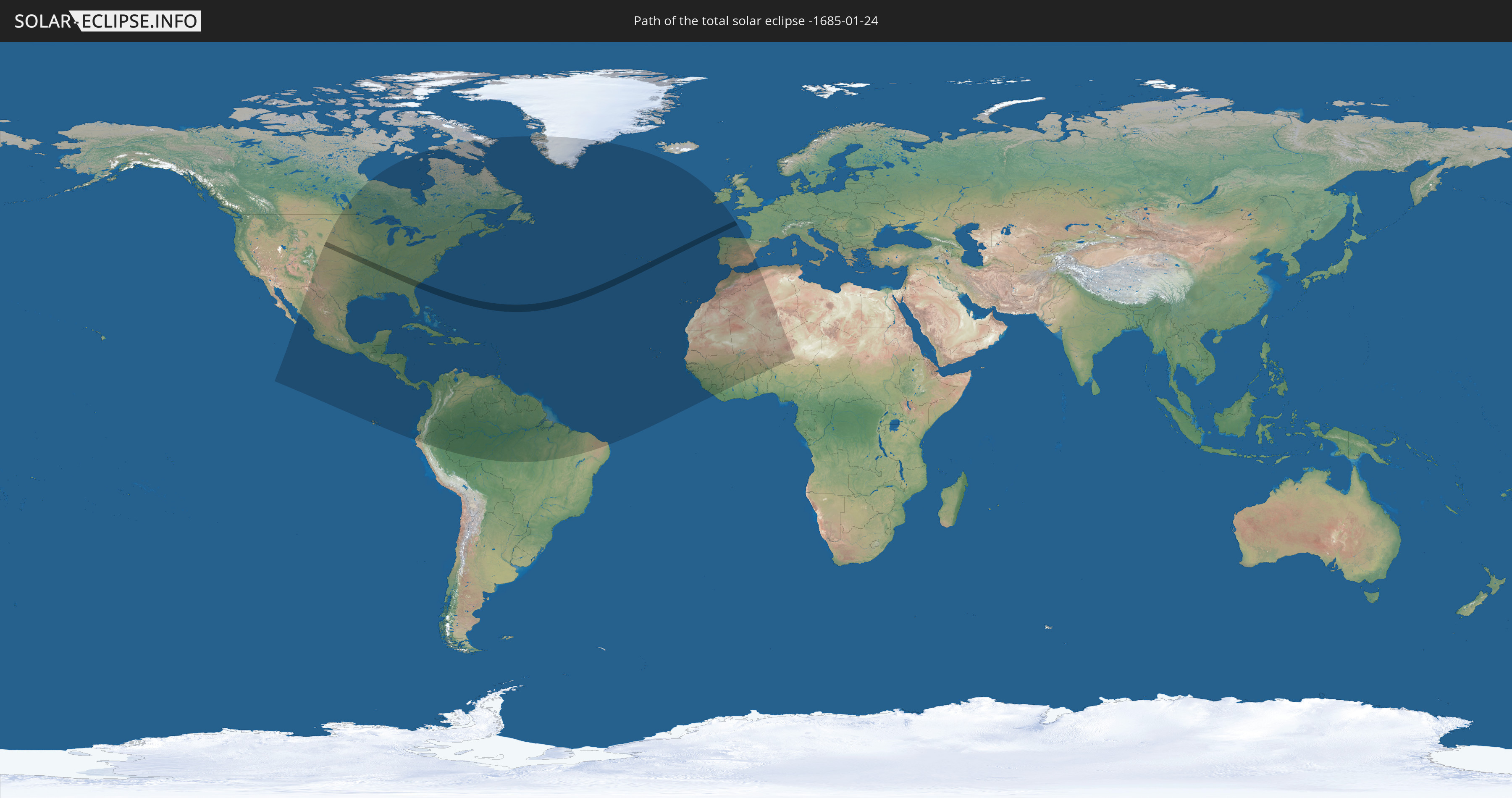
Die Sonnenfinsternis am 01/24/-1685 kann man in 69 Ländern als partielle Sonnenfinsternis beobachten.
Der Finsternispfad verläuft durch 2 Länder. Nur in diesen Ländern ist sie als total Sonnenfinsternis zu sehen.
In den folgenden Ländern ist die Sonnenfinsternis total zu sehen
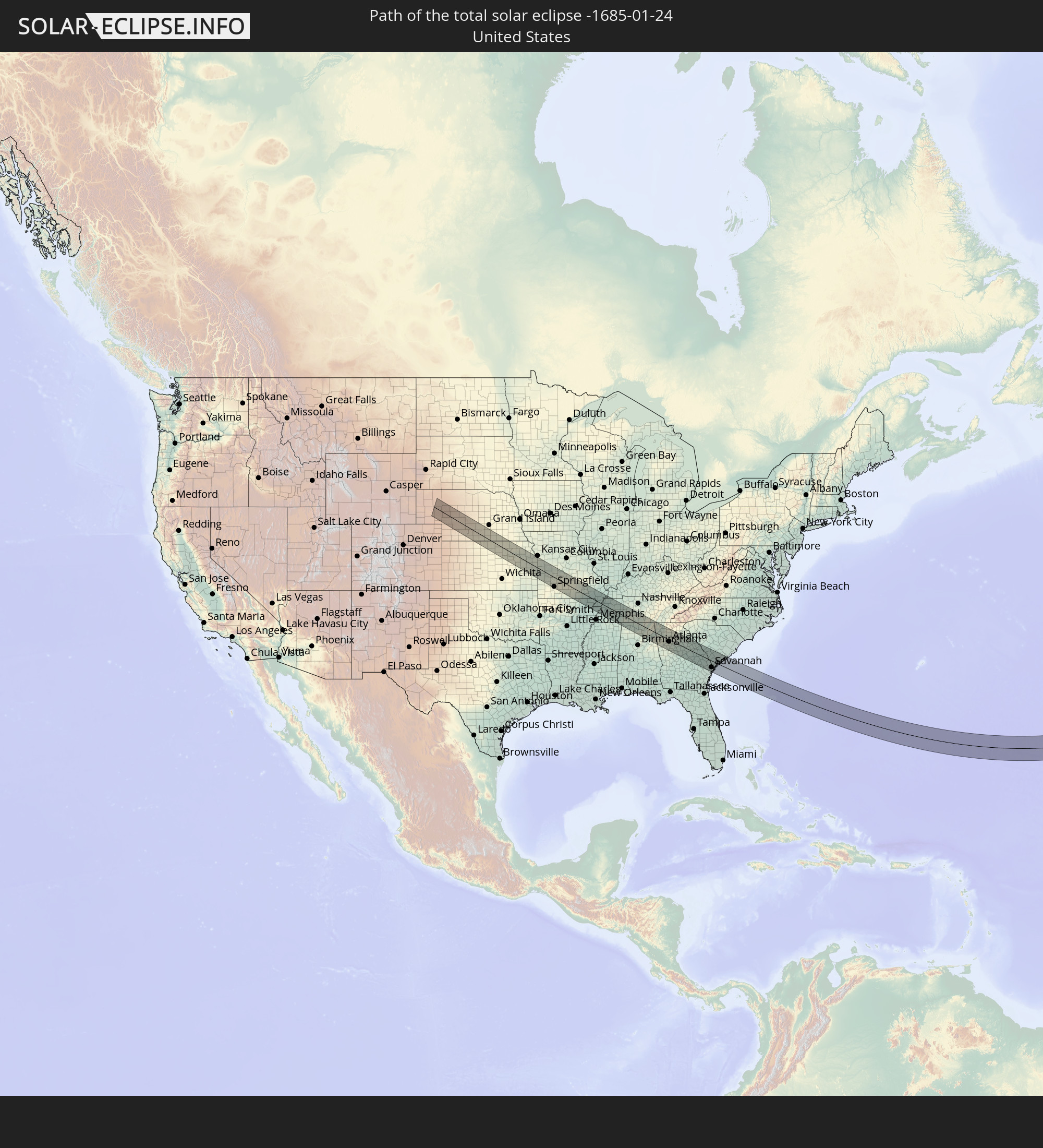 United States
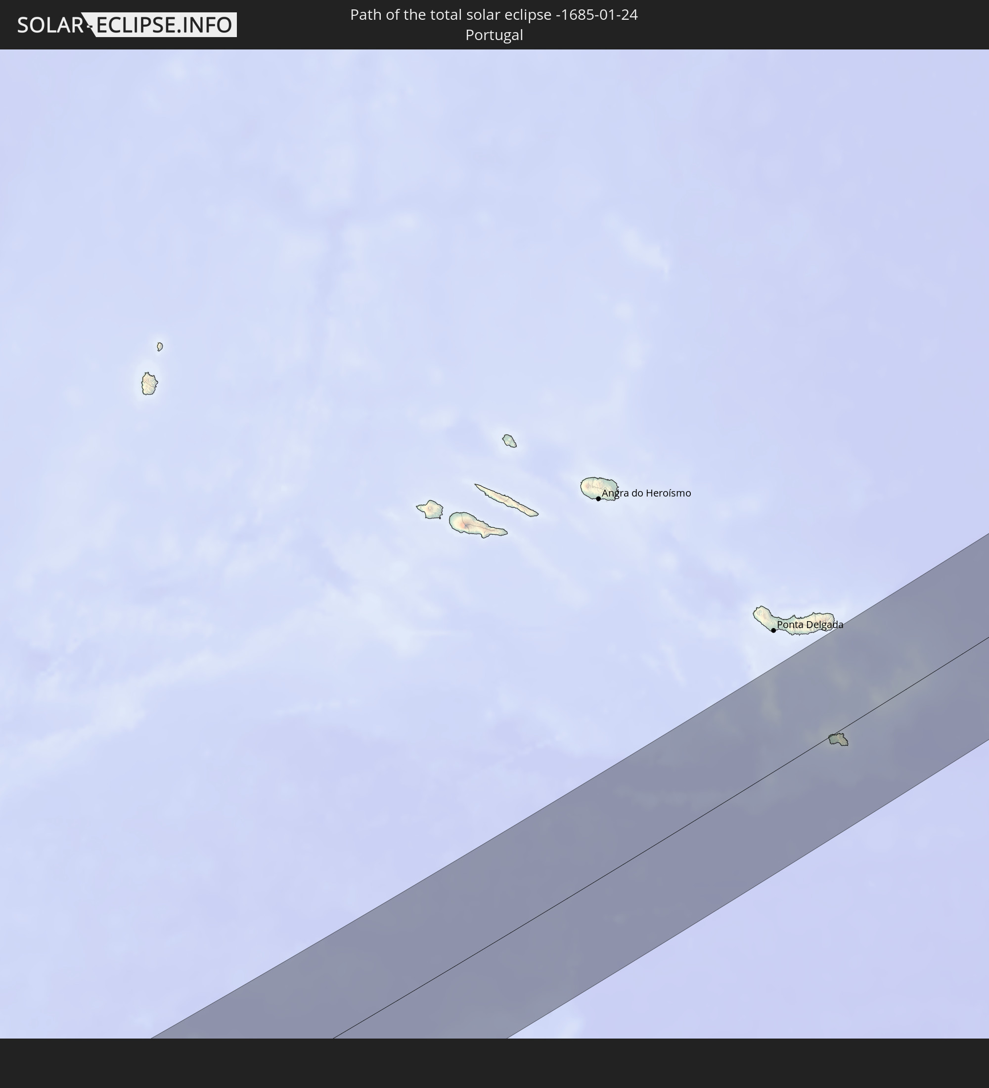 Portugal
In den folgenden Ländern ist die Sonnenfinsternis partiell zu sehen
 United States
 United States Minor Outlying Islands
 Canada
 Mexico
 Greenland
 Guatemala
 Ecuador
 El Salvador
 Honduras
 Belize
 Nicaragua
 Costa Rica
 Cuba
Cuba
 Panama
 Colombia
 Cayman Islands
 Peru
Peru
 The Bahamas
 Jamaica
 Haiti
Haiti
 Brazil
 Venezuela
 Turks and Caicos Islands
 Dominican Republic
 Aruba
Aruba
 Puerto Rico
 United States Virgin Islands
 Bermuda
 British Virgin Islands
 Anguilla
 Collectivity of Saint Martin
 Saint Barthélemy
 Saint Kitts and Nevis
 Antigua and Barbuda
 Montserrat
 Trinidad and Tobago
 Guadeloupe
 Grenada
 Dominica
 Saint Vincent and the Grenadines
 Guyana
 Martinique
 Saint Lucia
 Barbados
 Suriname
 Saint Pierre and Miquelon
 French Guiana
 Portugal
 Cabo Verde
 Spain
Spain
 Senegal
 Mauritania
 The Gambia
 Guinea-Bissau
 Guinea
 Sierra Leone
 Morocco
 Mali
Mali
 Liberia
 Republic of Ireland
 Algeria
 Ivory Coast
 Burkina Faso
 Gibraltar
 Ghana
Ghana
 Togo
Togo
 Niger
Niger
 Benin
Benin
 Nigeria
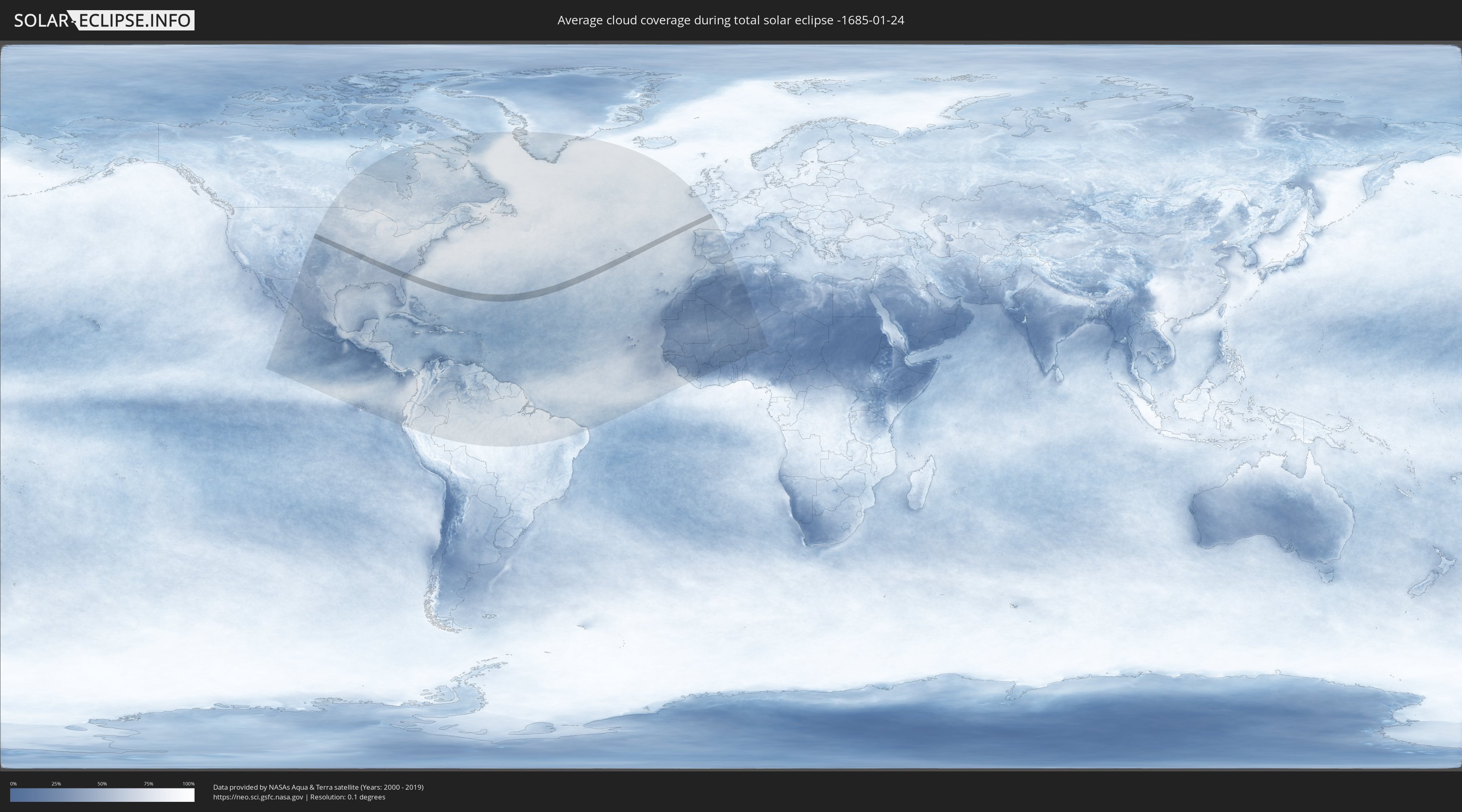
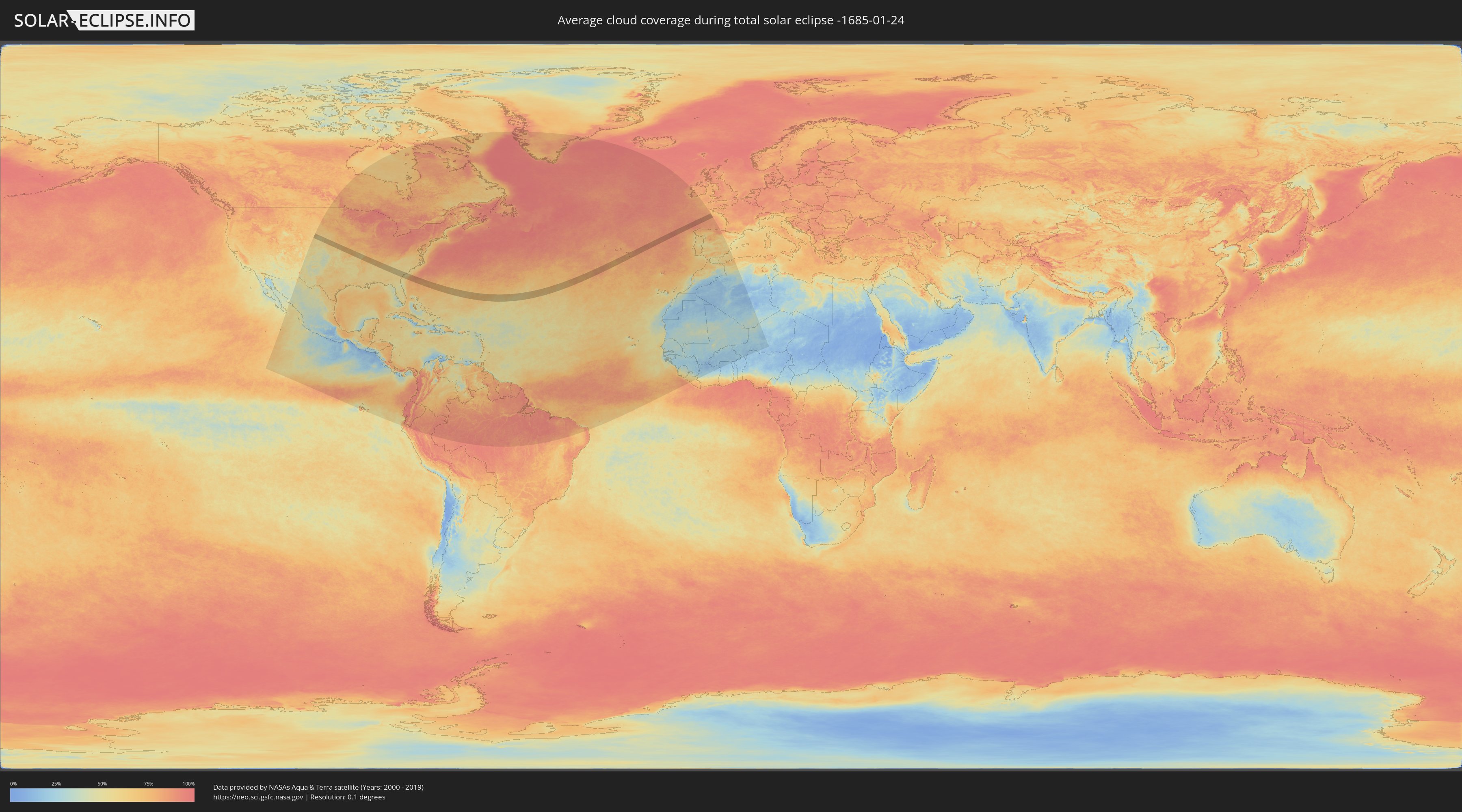
How will be the weather during the total solar eclipse on 01/24/-1685?
Where is the best place to see the total solar eclipse of 01/24/-1685?
The following maps show the average cloud coverage for the day of the total solar eclipse.
With the help of these maps, it is possible to find the place along the eclipse path, which has the best
chance of a cloudless sky.
Nevertheless, you should consider local circumstances and inform about the weather of your chosen
observation site.
The data is provided by NASAs satellites
AQUA and TERRA.
The cloud maps are averaged over a period of 19 years (2000 - 2019).
Detailed country maps
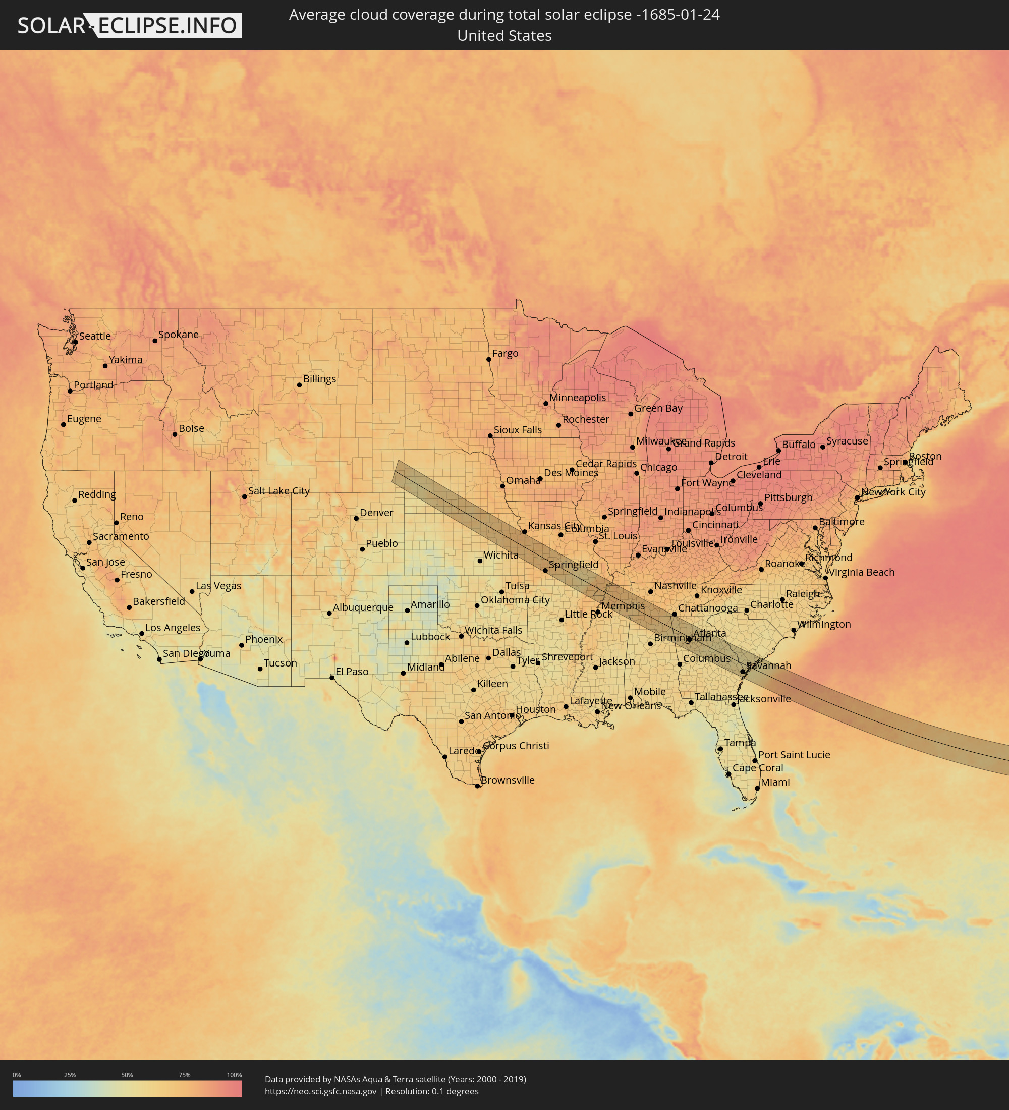 United States
 Portugal
Cities inside the path of the eclipse
The following table shows all locations with a population of more than 5,000 inside the eclipse path. Cities which have more than 100,000 inhabitants are marked bold. A click at the locations opens a detailed map.
| City | Type | Eclipse duration | Local time of max. eclipse | Distance to central line | Ø Cloud coverage |
|
North Platte, Nebraska
|
total | - | 08:33:35 UTC-06:00 | 3 km | 58% |
|
Lexington, Nebraska
|
total | - | 08:33:48 UTC-06:00 | 8 km | 64% |
|
Kearney, Nebraska
|
total | - | 08:34:08 UTC-06:00 | 29 km | 66% |
|
Hastings, Nebraska
|
total | - | 08:34:28 UTC-06:00 | 48 km | 68% |
|
Junction City, Kansas
|
total | - | 08:33:49 UTC-06:00 | 34 km | 65% |
|
Fort Riley North, Kansas
|
total | - | 08:33:55 UTC-06:00 | 26 km | 68% |
|
Manhattan, Kansas
|
total | - | 08:34:11 UTC-06:00 | 8 km | 68% |
|
Topeka, Kansas
|
total | - | 08:34:43 UTC-06:00 | 17 km | 74% |
|
Ottawa, Kansas
|
total | - | 08:34:34 UTC-06:00 | 6 km | 70% |
|
Lawrence, Kansas
|
total | - | 08:34:59 UTC-06:00 | 29 km | 74% |
|
Eudora, Kansas
|
total | - | 08:35:04 UTC-06:00 | 32 km | 74% |
|
Gardner, Kansas
|
total | - | 08:35:03 UTC-06:00 | 27 km | 76% |
|
Bonner Springs, Kansas
|
total | - | 08:35:22 UTC-06:00 | 53 km | 75% |
|
Olathe, Kansas
|
total | - | 08:35:13 UTC-06:00 | 39 km | 76% |
|
Fort Scott, Kansas
|
total | - | 08:34:11 UTC-06:00 | 57 km | 66% |
|
Merriam, Kansas
|
total | - | 08:35:29 UTC-06:00 | 58 km | 76% |
|
Overland Park, Kansas
|
total | - | 08:35:27 UTC-06:00 | 55 km | 76% |
|
Mission, Kansas
|
total | - | 08:35:31 UTC-06:00 | 60 km | 76% |
|
Prairie Village, Kansas
|
total | - | 08:35:29 UTC-06:00 | 57 km | 74% |
|
Roeland Park, Kansas
|
total | - | 08:35:33 UTC-06:00 | 62 km | 74% |
|
Leawood, Kansas
|
total | - | 08:35:29 UTC-06:00 | 56 km | 74% |
|
Grandview, Missouri
|
total | - | 08:35:28 UTC-06:00 | 51 km | 74% |
|
Belton, Missouri
|
total | - | 08:35:23 UTC-06:00 | 44 km | 74% |
|
Raymore, Missouri
|
total | - | 08:35:26 UTC-06:00 | 47 km | 74% |
|
Lee's Summit, Missouri
|
total | - | 08:35:37 UTC-06:00 | 60 km | 75% |
|
Nevada, Missouri
|
total | - | 08:34:29 UTC-06:00 | 42 km | 71% |
|
Harrisonville, Missouri
|
total | - | 08:35:22 UTC-06:00 | 37 km | 72% |
|
Pleasant Hill, Missouri
|
total | - | 08:35:34 UTC-06:00 | 53 km | 73% |
|
Clinton, Missouri
|
total | - | 08:35:32 UTC-06:00 | 34 km | 72% |
|
Bolivar, Missouri
|
total | - | 08:35:03 UTC-06:00 | 23 km | 77% |
|
Springfield, Missouri
|
total | - | 08:34:44 UTC-06:00 | 57 km | 71% |
|
Marshfield, Missouri
|
total | - | 08:35:13 UTC-06:00 | 28 km | 70% |
|
Lebanon, Missouri
|
total | - | 08:35:47 UTC-06:00 | 16 km | 71% |
|
Saint John, Missouri
|
total | - | 08:36:16 UTC-06:00 | 49 km | 66% |
|
Fort Leonard Wood, Missouri
|
total | - | 08:36:17 UTC-06:00 | 41 km | 60% |
|
West Plains, Missouri
|
total | - | 08:35:34 UTC-06:00 | 41 km | 65% |
|
Pocahontas, Arkansas
|
total | - | 08:35:56 UTC-06:00 | 48 km | 65% |
|
Paragould, Arkansas
|
total | - | 08:36:12 UTC-06:00 | 48 km | 69% |
|
Poplar Bluff, Missouri
|
total | - | 08:37:01 UTC-06:00 | 25 km | 68% |
|
Kennett, Missouri
|
total | - | 08:36:50 UTC-06:00 | 11 km | 66% |
|
Osceola, Arkansas
|
total | - | 08:36:24 UTC-06:00 | 59 km | 72% |
|
Dexter, Missouri
|
total | - | 08:37:30 UTC-06:00 | 48 km | 74% |
|
Blytheville, Arkansas
|
total | - | 08:36:40 UTC-06:00 | 36 km | 72% |
|
Caruthersville, Missouri
|
total | - | 08:37:12 UTC-06:00 | 2 km | 69% |
|
Covington, Tennessee
|
total | - | 08:36:36 UTC-06:00 | 59 km | 74% |
|
Ripley, Tennessee
|
total | - | 08:36:54 UTC-06:00 | 36 km | 72% |
|
Dyersburg, Tennessee
|
total | - | 08:37:20 UTC-06:00 | 2 km | 73% |
|
Brownsville, Tennessee
|
total | - | 08:37:02 UTC-06:00 | 40 km | 70% |
|
Union City, Tennessee
|
total | - | 08:38:04 UTC-06:00 | 50 km | 75% |
|
Humboldt, Tennessee
|
total | - | 08:37:37 UTC-06:00 | 3 km | 74% |
|
Martin, Tennessee
|
total | - | 08:38:12 UTC-06:00 | 51 km | 75% |
|
Jackson, Tennessee
|
total | - | 08:37:32 UTC-06:00 | 18 km | 68% |
|
Milan, Tennessee
|
total | - | 08:37:53 UTC-06:00 | 14 km | 74% |
|
Henderson, Tennessee
|
total | - | 08:37:33 UTC-06:00 | 28 km | 67% |
|
Lexington, Tennessee
|
total | - | 08:38:02 UTC-06:00 | 3 km | 72% |
|
Savannah, Tennessee
|
total | - | 08:37:47 UTC-06:00 | 32 km | 65% |
|
Tuscumbia, Alabama
|
total | - | 08:37:56 UTC-06:00 | 57 km | 66% |
|
Sheffield, Alabama
|
total | - | 08:37:58 UTC-06:00 | 54 km | 67% |
|
Florence, Alabama
|
total | - | 08:38:01 UTC-06:00 | 50 km | 67% |
|
Muscle Shoals, Alabama
|
total | - | 08:37:59 UTC-06:00 | 55 km | 66% |
|
East Florence, Alabama
|
total | - | 08:38:04 UTC-06:00 | 47 km | 69% |
|
Lawrenceburg, Tennessee
|
total | - | 08:38:50 UTC-06:00 | 9 km | 73% |
|
Danville, Alabama
|
total | - | 08:38:21 UTC-06:00 | 62 km | 64% |
|
Columbia, Tennessee
|
total | - | 08:39:32 UTC-06:00 | 58 km | 71% |
|
Pulaski, Tennessee
|
total | - | 08:39:09 UTC-06:00 | 17 km | 71% |
|
Decatur, Alabama
|
total | - | 08:38:39 UTC-06:00 | 39 km | 67% |
|
Athens, Alabama
|
total | - | 08:38:50 UTC-06:00 | 19 km | 71% |
|
Hartselle, Alabama
|
total | - | 08:38:33 UTC-06:00 | 53 km | 64% |
|
Lewisburg, Tennessee
|
total | - | 08:39:40 UTC-06:00 | 52 km | 70% |
|
Madison, Alabama
|
total | - | 08:39:00 UTC-06:00 | 20 km | 67% |
|
Huntsville, Alabama
|
total | - | 08:39:14 UTC-06:00 | 10 km | 67% |
|
Meridianville, Alabama
|
total | - | 08:39:21 UTC-06:00 | 3 km | 71% |
|
Fayetteville, Tennessee
|
total | - | 08:39:38 UTC-06:00 | 32 km | 69% |
|
Arab, Alabama
|
total | - | 08:38:57 UTC-06:00 | 46 km | 65% |
|
Lynchburg, Tennessee
|
total | - | 08:40:00 UTC-06:00 | 54 km | 69% |
|
Guntersville, Alabama
|
total | - | 08:39:14 UTC-06:00 | 34 km | 63% |
|
Tullahoma, Tennessee
|
total | - | 08:40:16 UTC-06:00 | 69 km | 70% |
|
Albertville, Alabama
|
total | - | 08:39:15 UTC-06:00 | 39 km | 65% |
|
Boaz, Alabama
|
total | - | 08:39:15 UTC-06:00 | 44 km | 64% |
|
Winchester, Tennessee
|
total | - | 08:40:13 UTC-06:00 | 55 km | 72% |
|
Attalla, Alabama
|
total | - | 08:39:11 UTC-06:00 | 58 km | 59% |
|
Rainbow City, Alabama
|
total | - | 08:39:11 UTC-06:00 | 63 km | 58% |
|
Scottsboro, Alabama
|
total | - | 08:39:50 UTC-06:00 | 8 km | 64% |
|
Southside, Alabama
|
total | - | 08:39:10 UTC-06:00 | 65 km | 58% |
|
Gadsden, Alabama
|
total | - | 08:39:16 UTC-06:00 | 56 km | 58% |
|
Jacksonville, Alabama
|
total | - | 08:39:24 UTC-06:00 | 65 km | 58% |
|
Fort Payne, Alabama
|
total | - | 08:40:01 UTC-06:00 | 1 km | 63% |
|
Fairview, Georgia
|
total | - | 09:41:01 UTC-05:00 | 67 km | 62% |
|
LaFayette, Georgia
|
total | - | 09:40:48 UTC-05:00 | 43 km | 61% |
|
Fort Oglethorpe, Georgia
|
total | - | 09:41:04 UTC-05:00 | 68 km | 62% |
|
Cedartown, Georgia
|
total | - | 09:40:15 UTC-05:00 | 20 km | 60% |
|
Rome, Georgia
|
total | - | 09:40:33 UTC-05:00 | 4 km | 61% |
|
Bremen, Georgia
|
total | - | 09:40:05 UTC-05:00 | 48 km | 60% |
|
Carrollton, Georgia
|
total | - | 09:40:03 UTC-05:00 | 59 km | 63% |
|
Dalton, Georgia
|
total | - | 09:41:15 UTC-05:00 | 63 km | 63% |
|
Calhoun, Georgia
|
total | - | 09:41:02 UTC-05:00 | 37 km | 63% |
|
Villa Rica, Georgia
|
total | - | 09:40:23 UTC-05:00 | 38 km | 62% |
|
Dallas, Georgia
|
total | - | 09:40:39 UTC-05:00 | 15 km | 61% |
|
Cartersville, Georgia
|
total | - | 09:40:55 UTC-05:00 | 10 km | 61% |
|
Newnan, Georgia
|
total | - | 09:40:14 UTC-05:00 | 67 km | 58% |
|
Douglasville, Georgia
|
total | - | 09:40:37 UTC-05:00 | 28 km | 62% |
|
Powder Springs, Georgia
|
total | - | 09:40:48 UTC-05:00 | 15 km | 63% |
|
Acworth, Georgia
|
total | - | 09:41:00 UTC-05:00 | 6 km | 62% |
|
Lithia Springs, Georgia
|
total | - | 09:40:46 UTC-05:00 | 21 km | 62% |
|
Austell, Georgia
|
total | - | 09:40:49 UTC-05:00 | 18 km | 63% |
|
Kennesaw, Georgia
|
total | - | 09:41:02 UTC-05:00 | 4 km | 61% |
|
Tyrone, Georgia
|
total | - | 09:40:34 UTC-05:00 | 50 km | 60% |
|
Peachtree City, Georgia
|
total | - | 09:40:30 UTC-05:00 | 57 km | 58% |
|
Mableton, Georgia
|
total | - | 09:40:54 UTC-05:00 | 15 km | 63% |
|
Fairburn, Georgia
|
total | - | 09:40:40 UTC-05:00 | 40 km | 62% |
|
Marietta, Georgia
|
total | - | 09:41:03 UTC-05:00 | 0 km | 61% |
|
Fair Oaks, Georgia
|
total | - | 09:41:02 UTC-05:00 | 4 km | 62% |
|
Union City, Georgia
|
total | - | 09:40:45 UTC-05:00 | 36 km | 62% |
|
Woodstock, Georgia
|
total | - | 09:41:14 UTC-05:00 | 16 km | 60% |
|
Holly Springs, Georgia
|
total | - | 09:41:19 UTC-05:00 | 24 km | 61% |
|
Canton, Georgia
|
total | - | 09:41:23 UTC-05:00 | 30 km | 61% |
|
Vinings, Georgia
|
total | - | 09:41:05 UTC-05:00 | 5 km | 62% |
|
Fayetteville, Georgia
|
total | - | 09:40:44 UTC-05:00 | 46 km | 59% |
|
College Park, Georgia
|
total | - | 09:40:55 UTC-05:00 | 26 km | 64% |
|
East Point, Georgia
|
total | - | 09:40:58 UTC-05:00 | 23 km | 64% |
|
Riverdale, Georgia
|
total | - | 09:40:54 UTC-05:00 | 32 km | 62% |
|
Hapeville, Georgia
|
total | - | 09:40:59 UTC-05:00 | 23 km | 64% |
|
Atlanta, Georgia
|
total | - | 09:41:05 UTC-05:00 | 14 km | 64% |
|
Sandy Springs, Georgia
|
total | - | 09:41:15 UTC-05:00 | 4 km | 61% |
|
Forest Park, Georgia
|
total | - | 09:41:00 UTC-05:00 | 25 km | 62% |
|
Irondale, Georgia
|
total | - | 09:40:53 UTC-05:00 | 39 km | 60% |
|
Morrow, Georgia
|
total | - | 09:41:00 UTC-05:00 | 28 km | 61% |
|
Druid Hills, Georgia
|
total | - | 09:41:11 UTC-05:00 | 8 km | 61% |
|
Conley, Georgia
|
total | - | 09:41:05 UTC-05:00 | 21 km | 61% |
|
Lovejoy, Georgia
|
total | - | 09:40:55 UTC-05:00 | 41 km | 62% |
|
Gresham Park, Georgia
|
total | - | 09:41:09 UTC-05:00 | 15 km | 62% |
|
North Druid Hills, Georgia
|
total | - | 09:41:15 UTC-05:00 | 4 km | 61% |
|
North Decatur, Georgia
|
total | - | 09:41:14 UTC-05:00 | 6 km | 61% |
|
Milton, Georgia
|
total | - | 09:41:33 UTC-05:00 | 28 km | 61% |
|
Chamblee, Georgia
|
total | - | 09:41:20 UTC-05:00 | 4 km | 60% |
|
Decatur, Georgia
|
total | - | 09:41:14 UTC-05:00 | 7 km | 61% |
|
Doraville, Georgia
|
total | - | 09:41:21 UTC-05:00 | 6 km | 60% |
|
Hampton, Georgia
|
total | - | 09:40:54 UTC-05:00 | 45 km | 62% |
|
Candler-McAfee, Georgia
|
total | - | 09:41:13 UTC-05:00 | 11 km | 62% |
|
Panthersville, Georgia
|
total | - | 09:41:12 UTC-05:00 | 13 km | 62% |
|
Belvedere Park, Georgia
|
total | - | 09:41:15 UTC-05:00 | 8 km | 61% |
|
Scottdale, Georgia
|
total | - | 09:41:17 UTC-05:00 | 4 km | 61% |
|
Griffin, Georgia
|
total | - | 09:40:49 UTC-05:00 | 58 km | 59% |
|
Clarkston, Georgia
|
total | - | 09:41:20 UTC-05:00 | 1 km | 60% |
|
Stockbridge, Georgia
|
total | - | 09:41:07 UTC-05:00 | 27 km | 62% |
|
Tucker, Georgia
|
total | - | 09:41:24 UTC-05:00 | 4 km | 61% |
|
Norcross, Georgia
|
total | - | 09:41:29 UTC-05:00 | 13 km | 61% |
|
Johns Creek, Georgia
|
total | - | 09:41:35 UTC-05:00 | 22 km | 61% |
|
Stone Mountain, Georgia
|
total | - | 09:41:26 UTC-05:00 | 2 km | 60% |
|
McDonough, Georgia
|
total | - | 09:41:08 UTC-05:00 | 33 km | 60% |
|
Duluth, Georgia
|
total | - | 09:41:38 UTC-05:00 | 22 km | 62% |
|
Lilburn, Georgia
|
total | - | 09:41:32 UTC-05:00 | 11 km | 61% |
|
Redan, Georgia
|
total | - | 09:41:25 UTC-05:00 | 3 km | 61% |
|
Mountain Park, Georgia
|
total | - | 09:41:31 UTC-05:00 | 7 km | 60% |
|
Suwanee, Georgia
|
total | - | 09:41:46 UTC-05:00 | 30 km | 61% |
|
Sugar Hill, Georgia
|
total | - | 09:41:52 UTC-05:00 | 37 km | 60% |
|
Snellville, Georgia
|
total | - | 09:41:40 UTC-05:00 | 13 km | 61% |
|
Conyers, Georgia
|
total | - | 09:41:30 UTC-05:00 | 6 km | 61% |
|
Buford, Georgia
|
total | - | 09:41:55 UTC-05:00 | 39 km | 60% |
|
Lawrenceville, Georgia
|
total | - | 09:41:48 UTC-05:00 | 24 km | 61% |
|
Loganville, Georgia
|
total | - | 09:41:49 UTC-05:00 | 16 km | 61% |
|
Covington, Georgia
|
total | - | 09:41:39 UTC-05:00 | 6 km | 61% |
|
Auburn, Georgia
|
total | - | 09:42:04 UTC-05:00 | 36 km | 61% |
|
Gainesville, Georgia
|
total | - | 09:42:19 UTC-05:00 | 65 km | 58% |
|
Braselton, Georgia
|
total | - | 09:42:14 UTC-05:00 | 48 km | 61% |
|
Winder, Georgia
|
total | - | 09:42:11 UTC-05:00 | 39 km | 61% |
|
Monroe, Georgia
|
total | - | 09:42:01 UTC-05:00 | 19 km | 61% |
|
Jefferson, Georgia
|
total | - | 09:42:30 UTC-05:00 | 57 km | 59% |
|
Commerce, Georgia
|
total | - | 09:42:44 UTC-05:00 | 71 km | 59% |
|
Country Club Estates, Georgia
|
total | - | 09:42:36 UTC-05:00 | 51 km | 58% |
|
Eatonton, Georgia
|
total | - | 09:42:03 UTC-05:00 | 14 km | 54% |
|
Athens, Georgia
|
total | - | 09:42:37 UTC-05:00 | 50 km | 58% |
|
Milledgeville, Georgia
|
total | - | 09:42:03 UTC-05:00 | 32 km | 55% |
|
Sandersville, Georgia
|
total | - | 09:42:33 UTC-05:00 | 24 km | 58% |
|
Thomson, Georgia
|
total | - | 09:43:24 UTC-05:00 | 37 km | 53% |
|
Swainsboro, Georgia
|
total | - | 09:42:54 UTC-05:00 | 43 km | 56% |
|
Grovetown, Georgia
|
total | - | 09:43:49 UTC-05:00 | 48 km | 56% |
|
Evans, Georgia
|
total | - | 09:43:59 UTC-05:00 | 59 km | 55% |
|
Martinez, Georgia
|
total | - | 09:44:03 UTC-05:00 | 60 km | 55% |
|
Waynesboro, Georgia
|
total | - | 09:43:46 UTC-05:00 | 20 km | 55% |
|
Augusta, Georgia
|
total | - | 09:44:09 UTC-05:00 | 59 km | 54% |
|
North Augusta, South Carolina
|
total | - | 09:44:12 UTC-05:00 | 63 km | 54% |
|
Belvedere, South Carolina
|
total | - | 09:44:15 UTC-05:00 | 67 km | 53% |
|
Statesboro, Georgia
|
total | - | 09:43:34 UTC-05:00 | 35 km | 57% |
|
Richmond Hill, Georgia
|
total | - | 09:43:52 UTC-05:00 | 67 km | 58% |
|
Pooler, Georgia
|
total | - | 09:44:05 UTC-05:00 | 46 km | 61% |
|
Rincon, Georgia
|
total | - | 09:44:15 UTC-05:00 | 28 km | 57% |
|
Georgetown, Georgia
|
total | - | 09:44:01 UTC-05:00 | 59 km | 61% |
|
Garden City, Georgia
|
total | - | 09:44:13 UTC-05:00 | 43 km | 61% |
|
Savannah, Georgia
|
total | - | 09:44:17 UTC-05:00 | 44 km | 58% |
|
Skidaway Island, Georgia
|
total | - | 09:44:14 UTC-05:00 | 57 km | 61% |
|
Whitemarsh Island, Georgia
|
total | - | 09:44:22 UTC-05:00 | 46 km | 68% |
|
Wilmington Island, Georgia
|
total | - | 09:44:24 UTC-05:00 | 47 km | 68% |
|
Bluffton, South Carolina
|
total | - | 09:44:46 UTC-05:00 | 19 km | 60% |
|
Laurel Bay, South Carolina
|
total | - | 09:45:03 UTC-05:00 | 6 km | 57% |
|
Hilton Head Island, South Carolina
|
total | - | 09:44:55 UTC-05:00 | 16 km | 57% |
|
Burton, South Carolina
|
total | - | 09:45:08 UTC-05:00 | 7 km | 59% |
|
Port Royal, South Carolina
|
total | - | 09:45:08 UTC-05:00 | 3 km | 59% |
|
Beaufort, South Carolina
|
total | - | 09:45:13 UTC-05:00 | 9 km | 59% |
|
Charleston, South Carolina
|
total | - | 09:46:37 UTC-05:00 | 73 km | 58% |