Total solar eclipse of 02/21/-1826
| Day of week: | Saturday |
| Maximum duration of eclipse: | 03m11s |
| Maximum width of eclipse path: | 198 km |
| Saros cycle: | 1 |
| Coverage: | 100% |
| Magnitude: | 1.0459 |
| Gamma: | -0.6416 |
Wo kann man die Sonnenfinsternis vom 02/21/-1826 sehen?
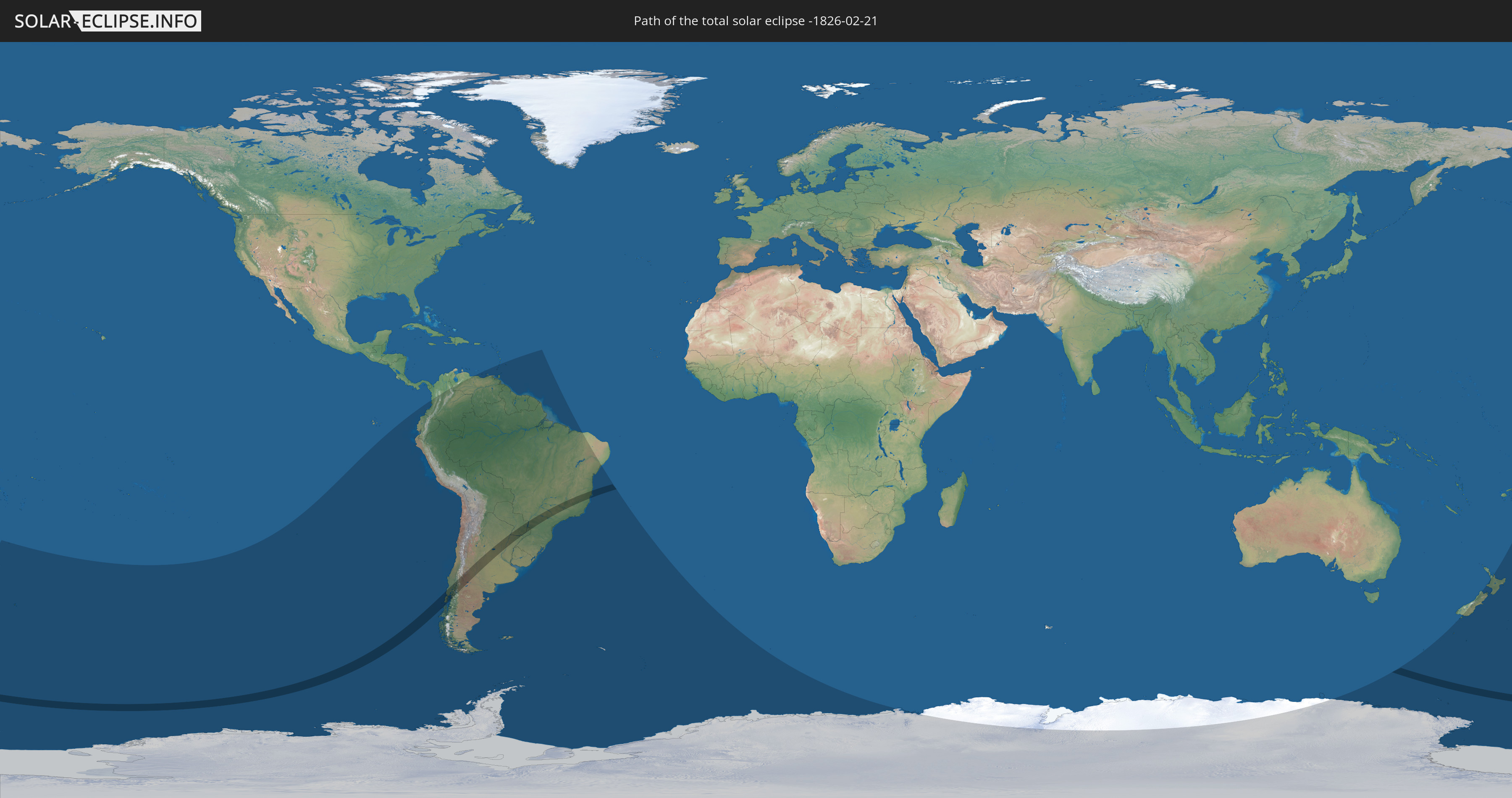
Die Sonnenfinsternis am 02/21/-1826 kann man in 21 Ländern als partielle Sonnenfinsternis beobachten.
Der Finsternispfad verläuft durch 4 Länder. Nur in diesen Ländern ist sie als total Sonnenfinsternis zu sehen.
In den folgenden Ländern ist die Sonnenfinsternis total zu sehen
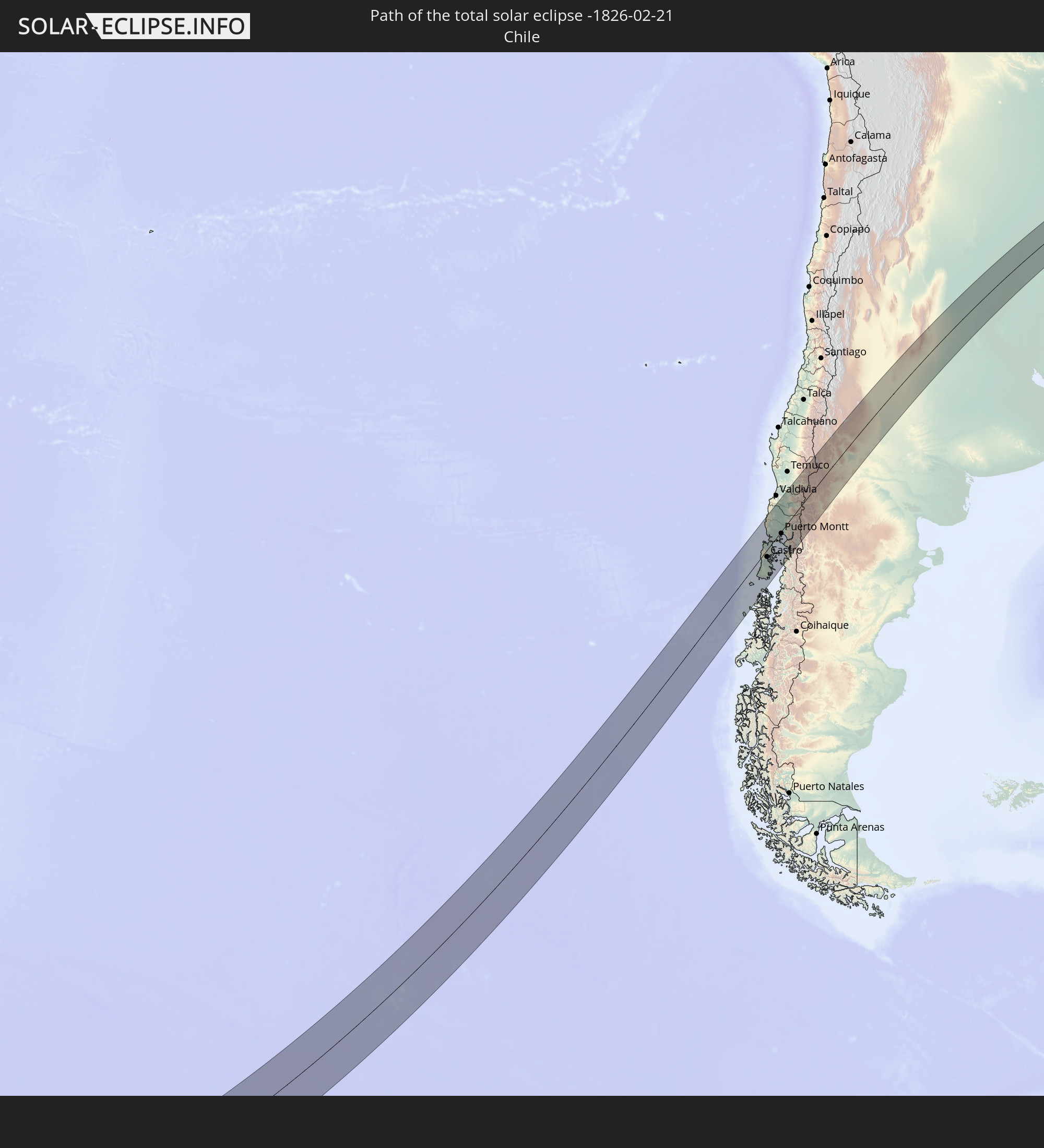 Chile
Chile
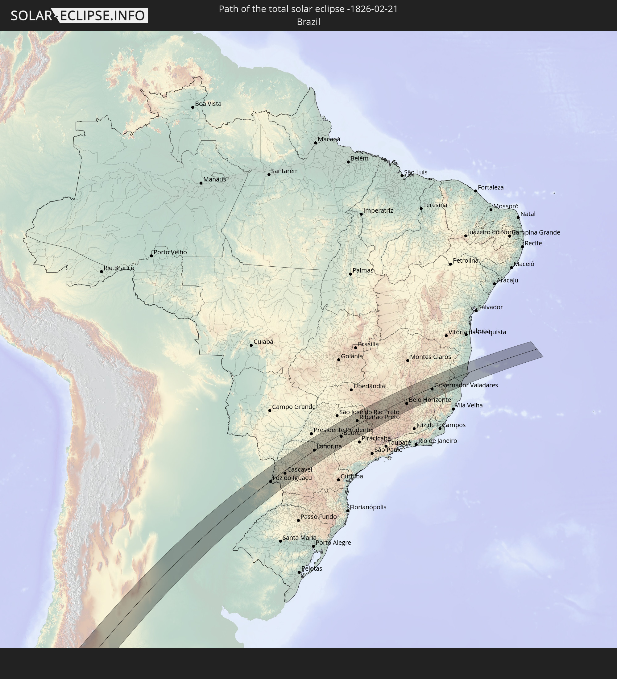 Brazil
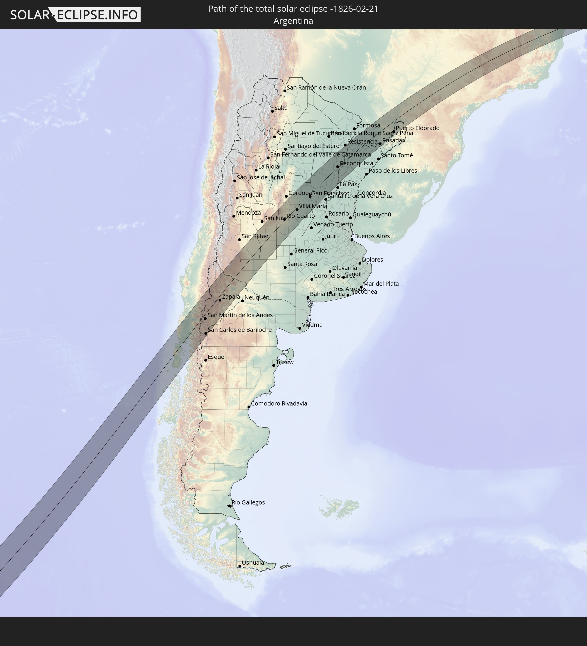 Argentina
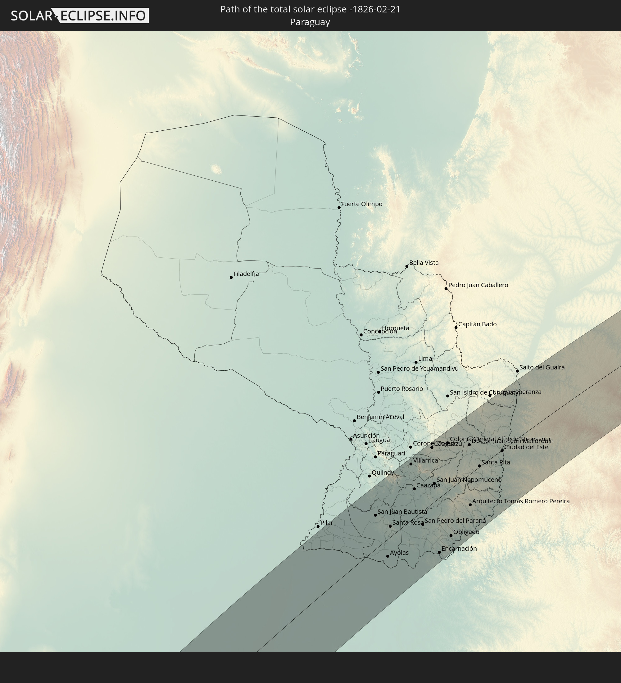 Paraguay
In den folgenden Ländern ist die Sonnenfinsternis partiell zu sehen


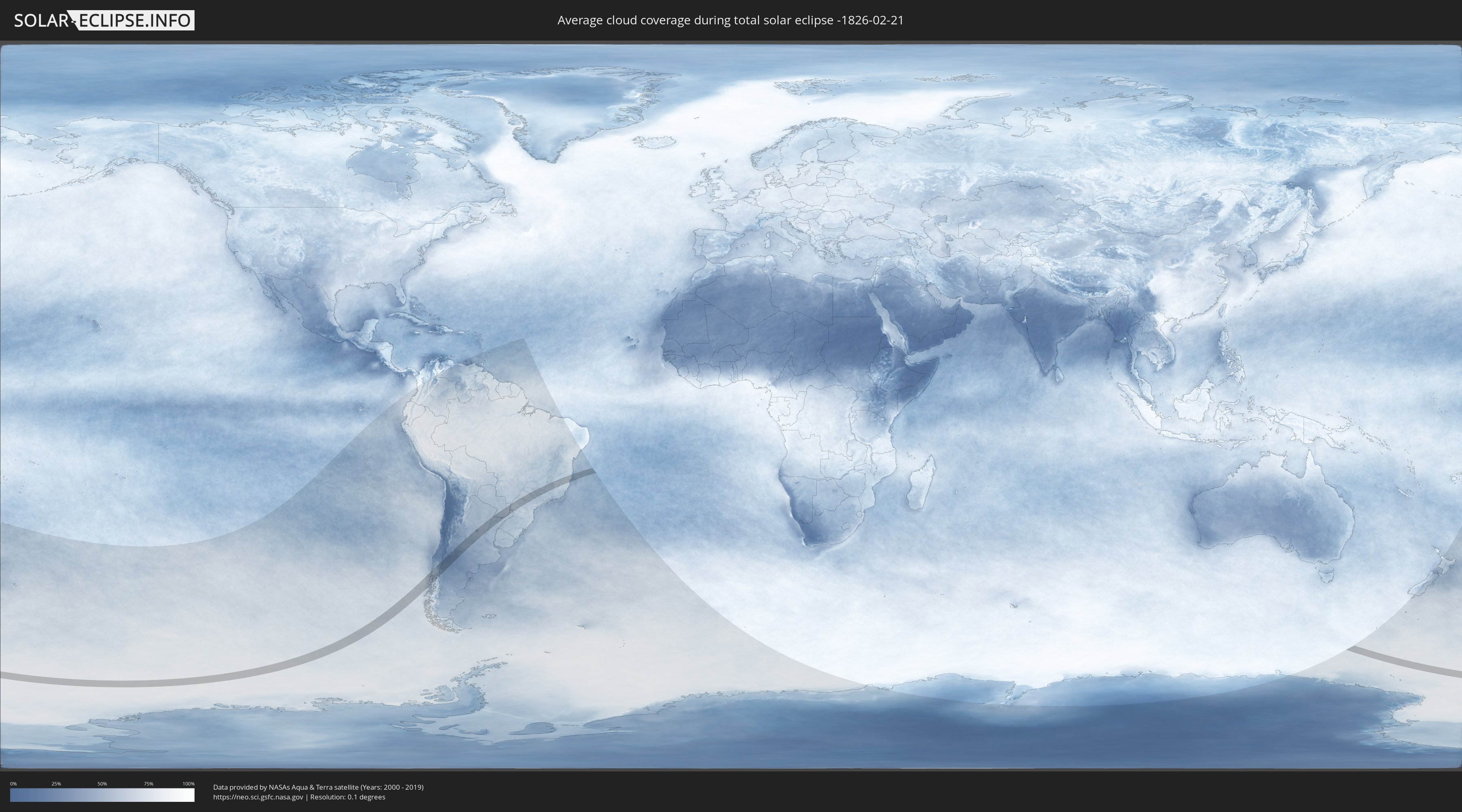
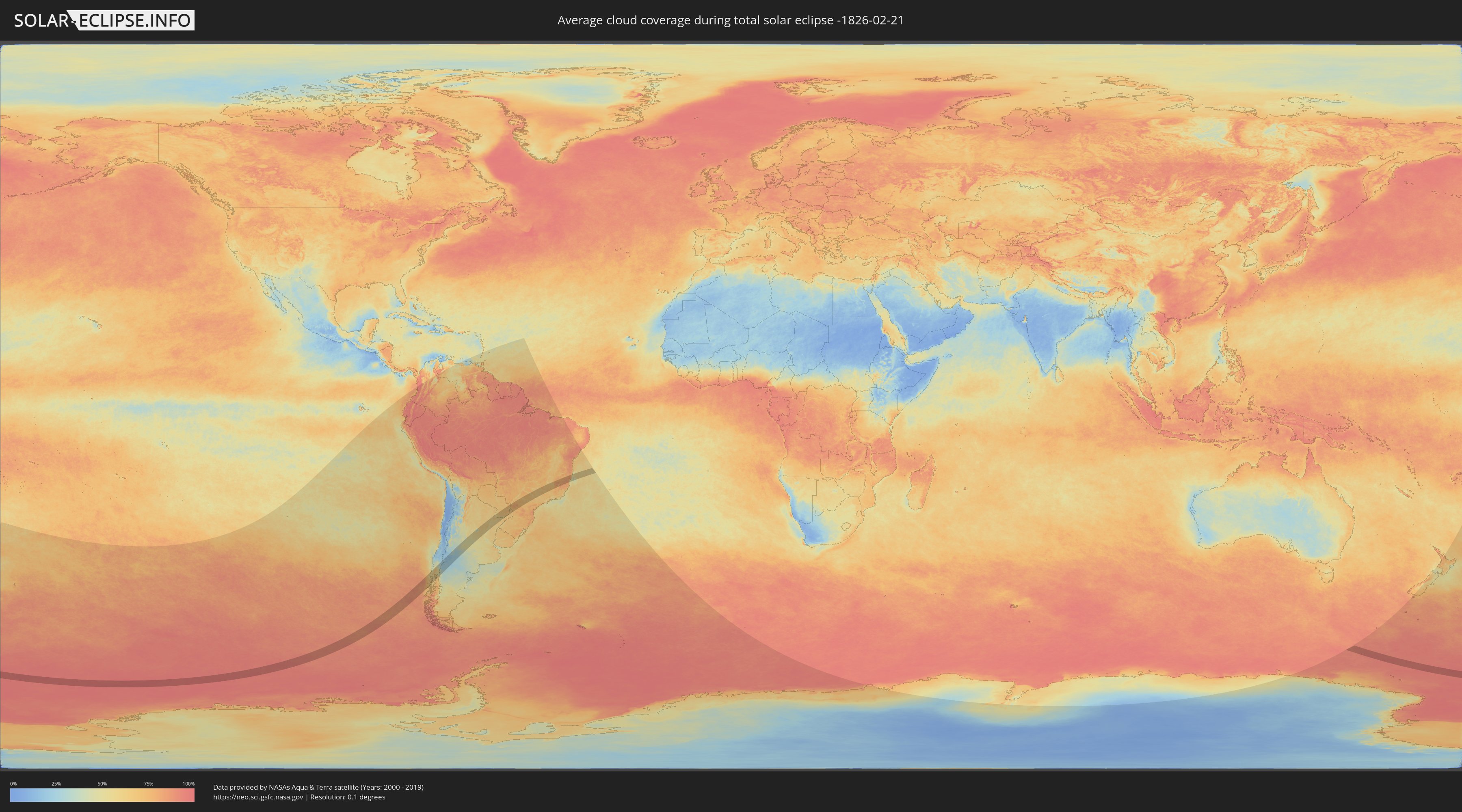
How will be the weather during the total solar eclipse on 02/21/-1826?
Where is the best place to see the total solar eclipse of 02/21/-1826?
The following maps show the average cloud coverage for the day of the total solar eclipse.
With the help of these maps, it is possible to find the place along the eclipse path, which has the best
chance of a cloudless sky.
Nevertheless, you should consider local circumstances and inform about the weather of your chosen
observation site.
The data is provided by NASAs satellites
AQUA and TERRA.
The cloud maps are averaged over a period of 19 years (2000 - 2019).
Detailed country maps
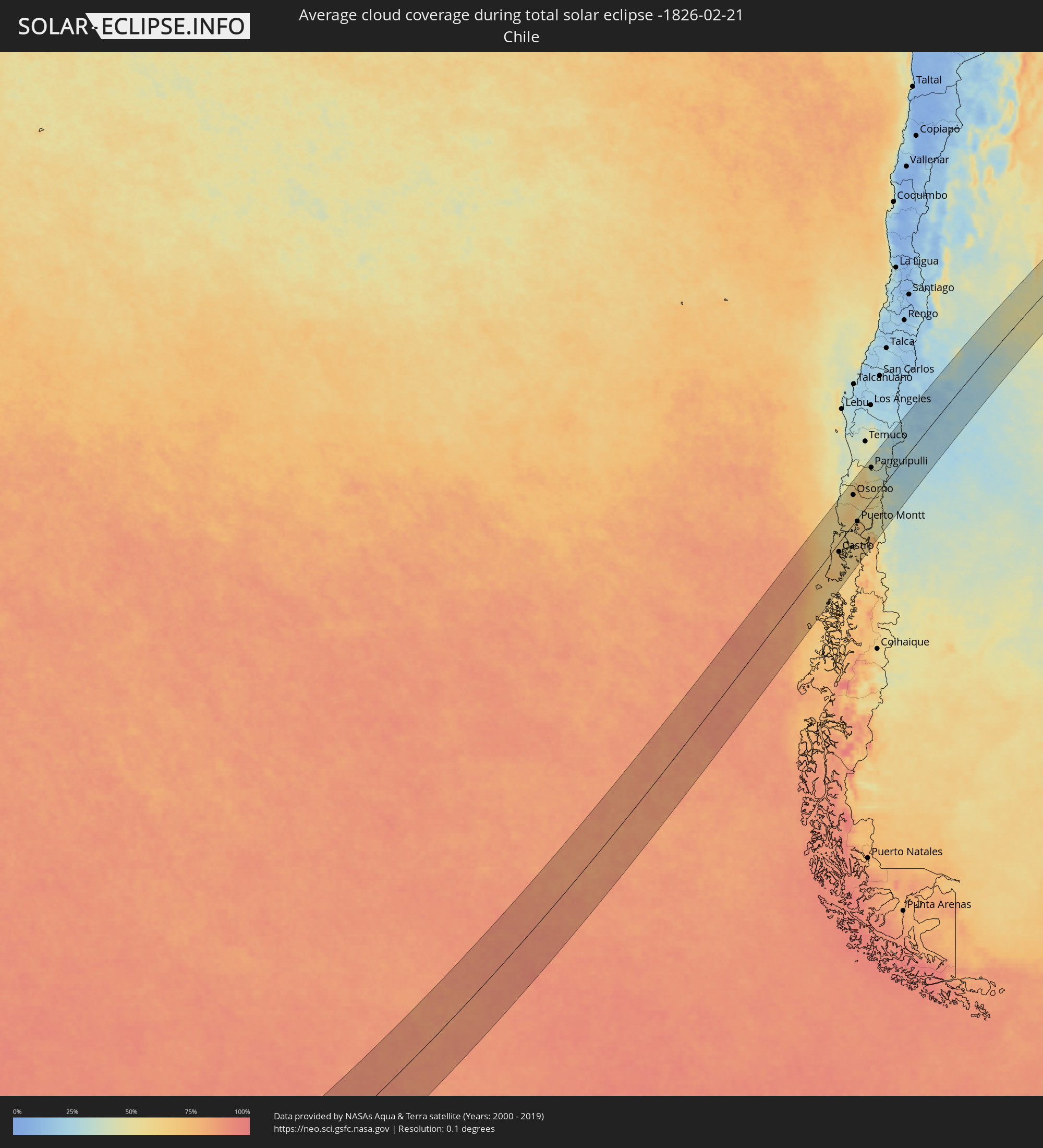 Chile
Chile
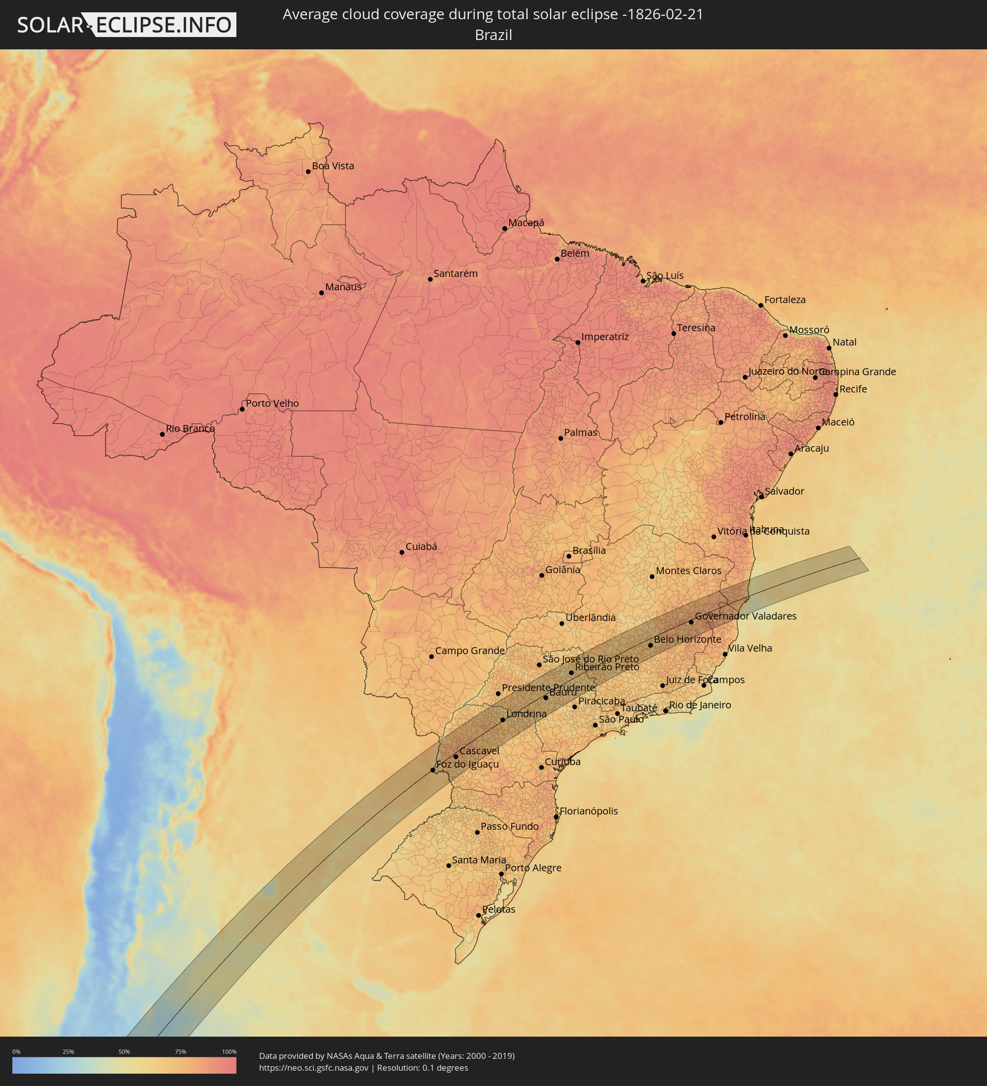 Brazil
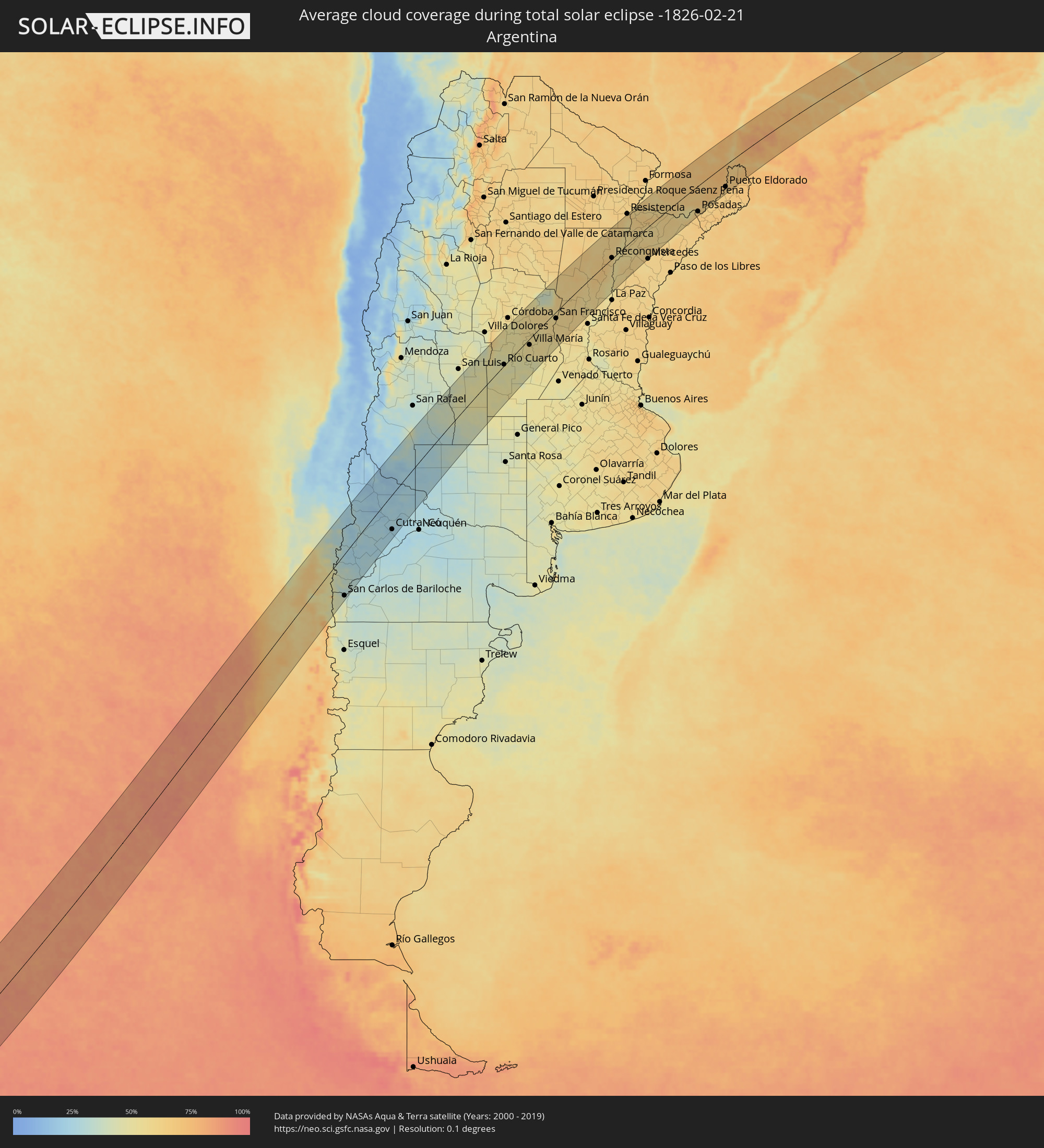 Argentina
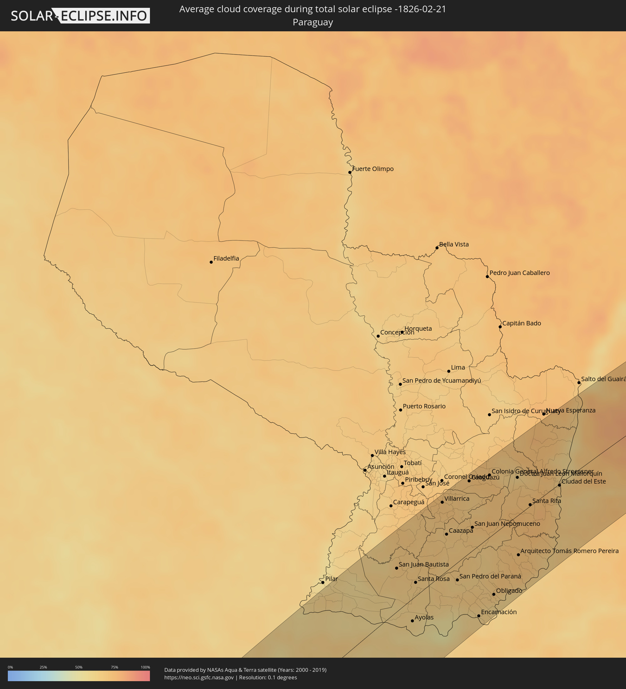 Paraguay
Cities inside the path of the eclipse
The following table shows all locations with a population of more than 5,000 inside the eclipse path. Cities which have more than 100,000 inhabitants are marked bold. A click at the locations opens a detailed map.
| City | Type | Eclipse duration | Local time of max. eclipse | Distance to central line | Ø Cloud coverage |
 Ancud, Los Lagos
|
total | - | 15:17:26 UTC-04:42 | 26 km | 60% |
|
Chonchi, Los Lagos
|
total | - | 15:16:02 UTC-04:42 | 32 km | 67% |
|
Castro, Los Lagos
|
total | - | 15:16:19 UTC-04:42 | 21 km | 65% |
|
Puerto Quellón, Los Lagos
|
total | - | 15:15:13 UTC-04:42 | 77 km | 64% |
|
Purranque, Los Lagos
|
total | - | 15:19:50 UTC-04:42 | 55 km | 64% |
|
Osorno, Los Lagos
|
total | - | 15:20:31 UTC-04:42 | 66 km | 63% |
|
Calbuco, Los Lagos
|
total | - | 15:18:12 UTC-04:42 | 34 km | 61% |
|
La Unión, Los Ríos
|
total | - | 15:21:06 UTC-04:42 | 86 km | 63% |
|
Frutillar, Los Lagos
|
total | - | 15:19:31 UTC-04:42 | 32 km | 60% |
|
Puerto Varas, Los Lagos
|
total | - | 15:19:12 UTC-04:42 | 11 km | 66% |
|
Río Bueno, Los Ríos
|
total | - | 15:21:08 UTC-04:42 | 76 km | 66% |
|
Puerto Montt, Los Lagos
|
total | - | 15:18:57 UTC-04:42 | 7 km | 66% |
|
Panguipulli, Araucanía
|
total | - | 15:22:59 UTC-04:42 | 79 km | 44% |
|
Villarrica, Araucanía
|
total | - | 15:23:45 UTC-04:42 | 97 km | 40% |
|
Pucón, Araucanía
|
total | - | 15:23:59 UTC-04:42 | 84 km | 39% |
 San Martín de los Andes, Neuquén Province
|
total | - | 15:48:45 UTC-04:16 | 26 km | 34% |
|
San Carlos de Bariloche, Río Negro Province
|
total | - | 15:46:53 UTC-04:16 | 98 km | 35% |
|
Junín de los Andes, Neuquén Province
|
total | - | 15:49:22 UTC-04:16 | 37 km | 26% |
|
Chos Malal, Neuquén Province
|
total | - | 15:54:57 UTC-04:16 | 97 km | 18% |
|
Zapala, Neuquén Province
|
total | - | 15:52:11 UTC-04:16 | 40 km | 25% |
|
Cutral-Có, Neuquén Province
|
total | - | 15:52:44 UTC-04:16 | 83 km | 24% |
|
Plaza Huincul, Neuquén Province
|
total | - | 15:52:46 UTC-04:16 | 84 km | 24% |
|
Villa Mercedes, San Luis Province
|
total | - | 16:05:18 UTC-04:16 | 37 km | 48% |
|
Embalse, Cordoba Province
|
total | - | 16:08:42 UTC-04:16 | 85 km | 50% |
|
Río Cuarto, Cordoba Province
|
total | - | 16:06:59 UTC-04:16 | 24 km | 49% |
|
Almafuerte, Cordoba Province
|
total | - | 16:08:46 UTC-04:16 | 75 km | 51% |
|
Río Tercero, Cordoba Province
|
total | - | 16:08:53 UTC-04:16 | 63 km | 51% |
|
Río Segundo, Cordoba Province
|
total | - | 16:09:58 UTC-04:16 | 93 km | 50% |
|
General Cabrera, Cordoba Province
|
total | - | 16:07:50 UTC-04:16 | 13 km | 51% |
|
Hernando, Cordoba Province
|
total | - | 16:08:38 UTC-04:16 | 22 km | 52% |
|
Oncativo, Cordoba Province
|
total | - | 16:09:36 UTC-04:16 | 58 km | 52% |
|
Oliva, Cordoba Province
|
total | - | 16:09:26 UTC-04:16 | 41 km | 54% |
|
La Carlota, Cordoba Province
|
total | - | 16:07:02 UTC-04:16 | 91 km | 49% |
|
Villa María, Cordoba Province
|
total | - | 16:08:56 UTC-04:16 | 24 km | 56% |
|
Arroyito, Cordoba Province
|
total | - | 16:10:51 UTC-04:16 | 54 km | 57% |
|
Las Varillas, Cordoba Province
|
total | - | 16:10:11 UTC-04:16 | 29 km | 53% |
|
Bell Ville, Cordoba Province
|
total | - | 16:08:49 UTC-04:16 | 79 km | 55% |
|
San Francisco, Cordoba Province
|
total | - | 16:11:19 UTC-04:16 | 36 km | 59% |
|
Morteros, Cordoba Province
|
total | - | 16:12:40 UTC-04:16 | 44 km | 61% |
|
Ceres, Santa Fe Province
|
total | - | 16:14:11 UTC-04:16 | 100 km | 59% |
|
San Jorge, Santa Fe Province
|
total | - | 16:10:35 UTC-04:16 | 73 km | 57% |
|
Sunchales, Santa Fe Province
|
total | - | 16:12:27 UTC-04:16 | 29 km | 59% |
|
Rafaela, Santa Fe Province
|
total | - | 16:11:56 UTC-04:16 | 51 km | 59% |
|
San Cristóbal, Santa Fe Province
|
total | - | 16:13:45 UTC-04:16 | 23 km | 61% |
|
Esperanza, Santa Fe Province
|
total | - | 16:11:50 UTC-04:16 | 100 km | 58% |
|
San Justo, Santa Fe Province
|
total | - | 16:13:11 UTC-04:16 | 69 km | 56% |
|
Vera, Santa Fe Province
|
total | - | 16:15:43 UTC-04:16 | 21 km | 65% |
|
San Javier, Santa Fe Province
|
total | - | 16:13:51 UTC-04:16 | 97 km | 52% |
|
Reconquista, Santa Fe Province
|
total | - | 16:16:30 UTC-04:16 | 18 km | 60% |
|
Esquina, Corrientes Province
|
total | - | 16:15:02 UTC-04:16 | 77 km | 56% |
|
Villa Ocampo, Santa Fe Province
|
total | - | 16:17:47 UTC-04:16 | 40 km | 59% |
|
Goya, Corrientes Province
|
total | - | 16:16:40 UTC-04:16 | 25 km | 55% |
|
Las Toscas, Santa Fe Province
|
total | - | 16:18:03 UTC-04:16 | 43 km | 57% |
|
Santa Lucía, Corrientes Province
|
total | - | 16:17:00 UTC-04:16 | 37 km | 55% |
|
Corrientes, Corrientes Province
|
total | - | 16:19:43 UTC-04:16 | 95 km | 63% |
|
San Lorenzo, Corrientes Province
|
total | - | 16:18:37 UTC-04:16 | 31 km | 59% |
|
Saladas, Corrientes Province
|
total | - | 16:18:28 UTC-04:16 | 13 km | 57% |
|
San Luis del Palmar, Corrientes Province
|
total | - | 16:19:47 UTC-04:16 | 70 km | 62% |
 San Juan Bautista, Misiones
|
total | - | 16:47:49 UTC-03:50 | 57 km | 65% |
|
Ayolas, Misiones
|
total | - | 16:46:39 UTC-03:50 | 28 km | 57% |
|
Santa Rosa, Misiones
|
total | - | 16:47:34 UTC-03:50 | 36 km | 64% |
|
Villarrica, Guairá
|
total | - | 16:49:34 UTC-03:50 | 89 km | 71% |
|
Caazapá, Caazapá
|
total | - | 16:48:50 UTC-03:50 | 46 km | 67% |
|
San Pedro del Paraná, Itapúa
|
total | - | 16:47:49 UTC-03:50 | 30 km | 63% |
|
Caaguazú, Caaguazú
|
total | - | 16:50:10 UTC-03:50 | 88 km | 68% |
|
San Juan Nepomuceno, Caazapá
|
total | - | 16:49:07 UTC-03:50 | 38 km | 68% |
|
Repatriación, Caaguazú
|
total | - | 16:50:03 UTC-03:50 | 77 km | 68% |
|
Posadas, Misiones Province
|
total | - | 16:20:53 UTC-04:16 | 87 km | 66% |
|
Encarnación, Itapúa
|
total | - | 16:47:05 UTC-03:50 | 86 km | 62% |
|
Hohenau, Itapúa
|
total | - | 16:47:32 UTC-03:50 | 75 km | 63% |
|
Colonia General Alfredo Stroessner, Caaguazú
|
total | - | 16:50:24 UTC-03:50 | 82 km | 72% |
|
Obligado, Itapúa
|
total | - | 16:47:39 UTC-03:50 | 75 km | 64% |
|
Doctor Juan León Mallorquín, Alto Paraná
|
total | - | 16:50:27 UTC-03:50 | 47 km | 67% |
|
Arquitecto Tomás Romero Pereira, Itapúa
|
total | - | 16:48:40 UTC-03:50 | 50 km | 72% |
|
Santa Rita, Alto Paraná
|
total | - | 16:49:52 UTC-03:50 | 8 km | 73% |
|
Puerto Rico, Misiones Province
|
total | - | 16:22:05 UTC-04:16 | 91 km | 63% |
|
Montecarlo, Misiones Province
|
total | - | 16:22:32 UTC-04:16 | 91 km | 62% |
|
Puerto Eldorado, Misiones Province
|
total | - | 16:48:56 UTC-03:50 | 79 km | 64% |
|
Puerto Esperanza, Misiones Province
|
total | - | 16:23:27 UTC-04:16 | 44 km | 69% |
|
Presidente Franco, Alto Paraná
|
total | - | 16:50:24 UTC-03:50 | 18 km | 67% |
|
Ciudad del Este, Alto Paraná
|
total | - | 16:50:26 UTC-03:50 | 16 km | 67% |
 Foz do Iguaçu, Paraná
|
total | - | 17:34:35 UTC-03:06 | 17 km | 67% |
|
Puerto Iguazú, Misiones Province
|
total | - | 16:24:10 UTC-04:16 | 22 km | 64% |
|
Colonia Wanda, Misiones Province
|
total | - | 16:23:35 UTC-04:16 | 62 km | 69% |
|
Toledo, Paraná
|
total | - | 17:36:07 UTC-03:06 | 18 km | 78% |
|
Cascavel, Paraná
|
total | - | 17:35:47 UTC-03:06 | 21 km | 78% |
|
Umuarama, Paraná
|
total | - | 17:37:42 UTC-03:06 | 81 km | 75% |
|
Cianorte, Paraná
|
total | - | 17:37:59 UTC-03:06 | 52 km | 74% |
|
Paranavaí, Paraná
|
total | - | 17:38:55 UTC-03:06 | 95 km | 72% |
|
Campo Mourão, Paraná
|
total | - | 17:37:26 UTC-03:06 | 15 km | 74% |
|
Maringá, Paraná
|
total | - | 17:38:27 UTC-03:06 | 43 km | 76% |
|
Apucarana, Paraná
|
total | - | 17:38:20 UTC-03:06 | 6 km | 74% |
|
Arapongas, Paraná
|
total | - | 17:38:32 UTC-03:06 | 13 km | 74% |
|
Londrina, Paraná
|
total | - | 17:38:44 UTC-03:06 | 20 km | 72% |
|
Assis, São Paulo
|
total | - | 17:39:49 UTC-03:06 | 20 km | 71% |
|
Marília, São Paulo
|
total | - | 17:40:32 UTC-03:06 | 47 km | 71% |
|
Ourinhos, São Paulo
|
total | - | 17:39:23 UTC-03:06 | 41 km | 68% |
|
Lins, São Paulo
|
total | - | 17:41:20 UTC-03:06 | 79 km | 73% |
|
Bauru, São Paulo
|
total | - | 17:40:27 UTC-03:06 | 27 km | 71% |
|
Catanduva, São Paulo
|
total | - | 17:42:11 UTC-03:06 | 89 km | 72% |
|
Lençóis Paulista, São Paulo
|
total | - | 17:40:03 UTC-03:06 | 62 km | 73% |
|
Jaú, São Paulo
|
total | - | 17:40:30 UTC-03:06 | 52 km | 66% |
|
Bebedouro, São Paulo
|
total | - | 17:42:29 UTC-03:06 | 82 km | 67% |
|
Matão, São Paulo
|
total | - | 17:41:32 UTC-03:06 | 26 km | 69% |
|
Jaboticabal, São Paulo
|
total | - | 17:42:02 UTC-03:06 | 46 km | 67% |
|
Araraquara, São Paulo
|
total | - | 17:41:16 UTC-03:06 | 34 km | 66% |
|
Sertãozinho, São Paulo
|
total | - | 17:42:13 UTC-03:06 | 45 km | 66% |
|
São Carlos, São Paulo
|
total | - | 17:40:57 UTC-03:06 | 54 km | 67% |
|
Ribeirão Preto, São Paulo
|
total | - | 17:42:10 UTC-03:06 | 26 km | 65% |
|
Batatais, São Paulo
|
total | - | 17:42:35 UTC-03:06 | 42 km | 71% |
|
Pirassununga, São Paulo
|
total | - | 17:40:59 UTC-03:06 | 78 km | 64% |
|
Franca, São Paulo
|
total | - | 17:43:05 UTC-03:06 | 68 km | 70% |
|
Mococa, São Paulo
|
total | - | 17:41:46 UTC-03:06 | 50 km | 62% |
|
São Sebastião do Paraíso, Minas Gerais
|
total | - | 17:42:33 UTC-03:06 | 12 km | 67% |
|
Passos, Minas Gerais
|
total | - | 17:42:50 UTC-03:06 | 13 km | 67% |
|
Formiga, Minas Gerais
|
total | - | 17:43:10 UTC-03:06 | 21 km | 70% |
|
Divinópolis, Minas Gerais
|
total | - | 17:43:35 UTC-03:06 | 16 km | 73% |
|
Pará de Minas, Minas Gerais
|
total | - | 17:43:57 UTC-03:06 | 1 km | 69% |
|
Itaúna, Minas Gerais
|
total | - | 17:43:39 UTC-03:06 | 22 km | 72% |
|
Esmeraldas, Minas Gerais
|
total | - | 17:44:04 UTC-03:06 | 3 km | 67% |
|
Sete Lagoas, Minas Gerais
|
total | - | 17:44:28 UTC-03:06 | 24 km | 71% |
|
Betim, Minas Gerais
|
total | - | 17:43:47 UTC-03:06 | 29 km | 69% |
|
Ribeirão das Neves, Minas Gerais
|
total | - | 17:44:02 UTC-03:06 | 14 km | 69% |
|
Ibirité, Minas Gerais
|
total | - | 17:43:42 UTC-03:06 | 41 km | 70% |
|
Belo Horizonte, Minas Gerais
|
total | - | 17:43:49 UTC-03:06 | 36 km | 66% |
|
Santa Luzia, Minas Gerais
|
total | - | 17:44:01 UTC-03:06 | 25 km | 67% |
|
Itabira, Minas Gerais
|
total | - | 17:44:10 UTC-03:06 | 37 km | 79% |
|
João Monlevade, Minas Gerais
|
total | - | 17:43:54 UTC-03:06 | 59 km | 79% |
|
Timóteo, Minas Gerais
|
total | - | 17:44:10 UTC-03:06 | 61 km | 70% |
|
Ipatinga, Minas Gerais
|
total | - | 17:44:18 UTC-03:06 | 52 km | 67% |
|
Governador Valadares, Minas Gerais
|
total | - | 17:45:02 UTC-03:06 | 15 km | 78% |
|
Teófilo Otoni, Minas Gerais
|
total | - | 17:46:16 UTC-03:06 | 68 km | 77% |
|
Nova Viçosa, Bahia
|
total | - | 18:18:19 UTC-02:34 | 21 km | 57% |