Total solar eclipse of 05/25/-1840
| Day of week: | Friday |
| Maximum duration of eclipse: | 05m50s |
| Maximum width of eclipse path: | 249 km |
| Saros cycle: | 8 |
| Coverage: | 100% |
| Magnitude: | 1.072 |
| Gamma: | 0.3401 |
Wo kann man die Sonnenfinsternis vom 05/25/-1840 sehen?
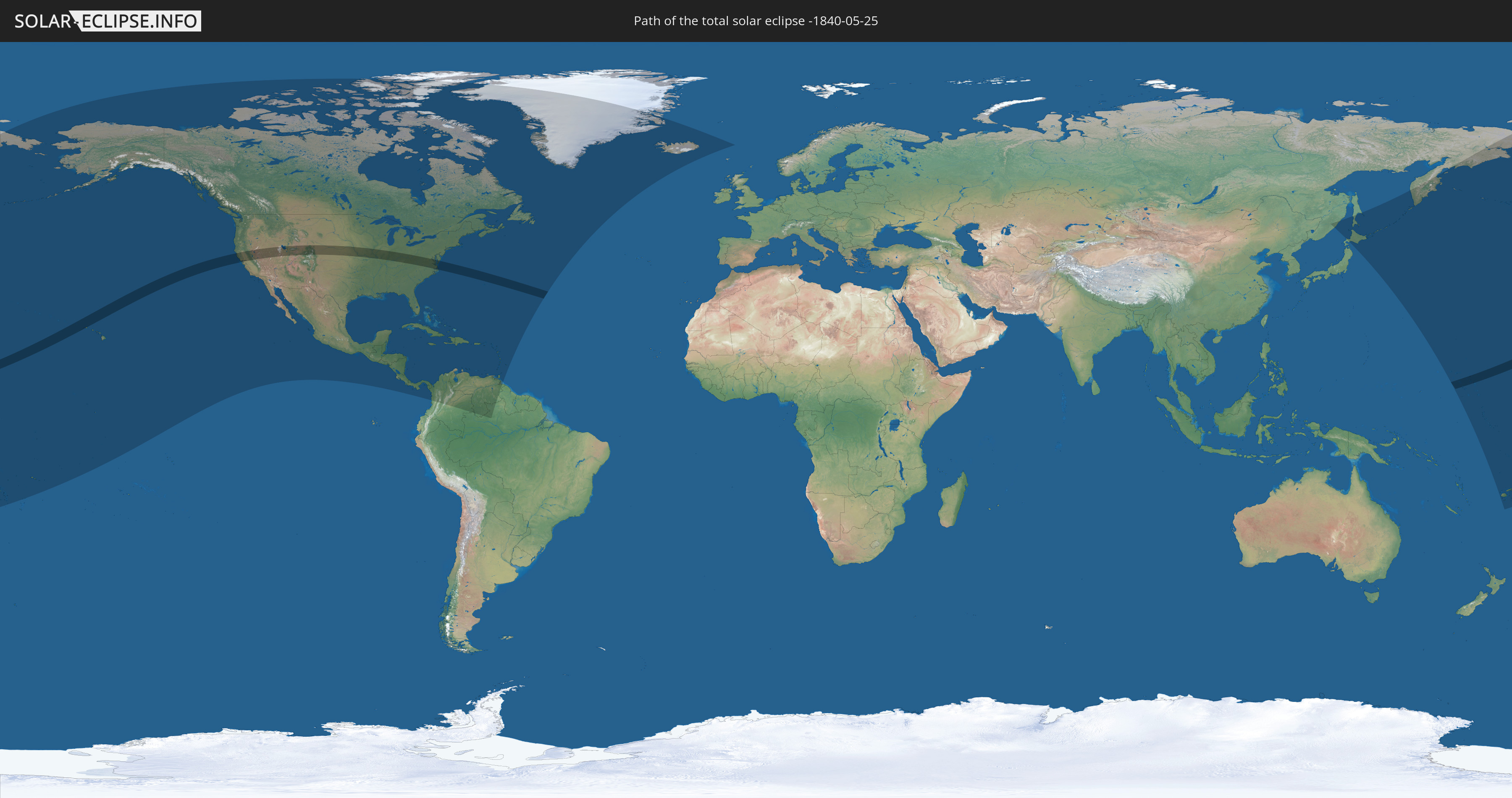
Die Sonnenfinsternis am 05/25/-1840 kann man in 56 Ländern als partielle Sonnenfinsternis beobachten.
Der Finsternispfad verläuft durch 2 Länder. Nur in diesen Ländern ist sie als total Sonnenfinsternis zu sehen.
In den folgenden Ländern ist die Sonnenfinsternis total zu sehen
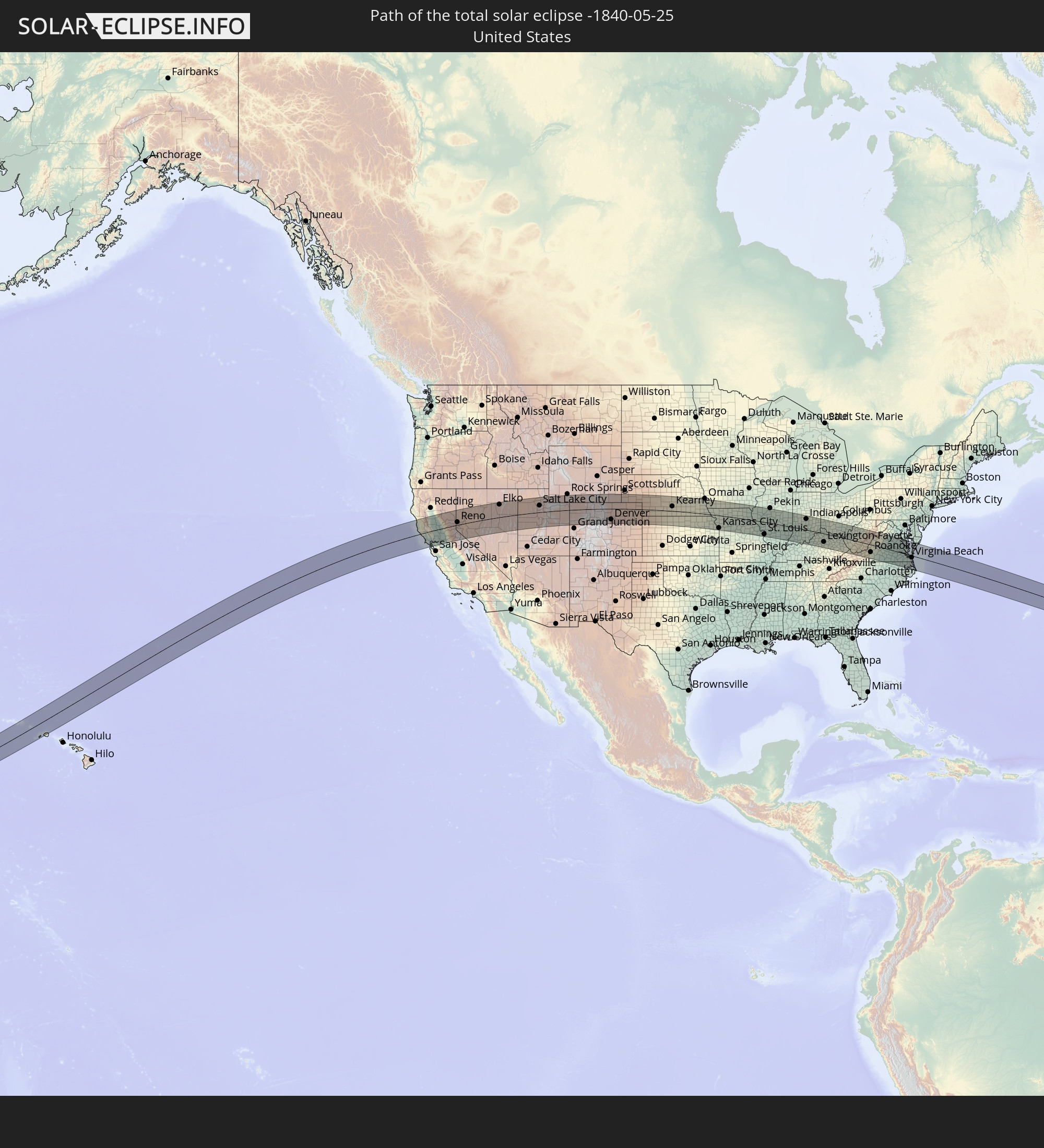 United States
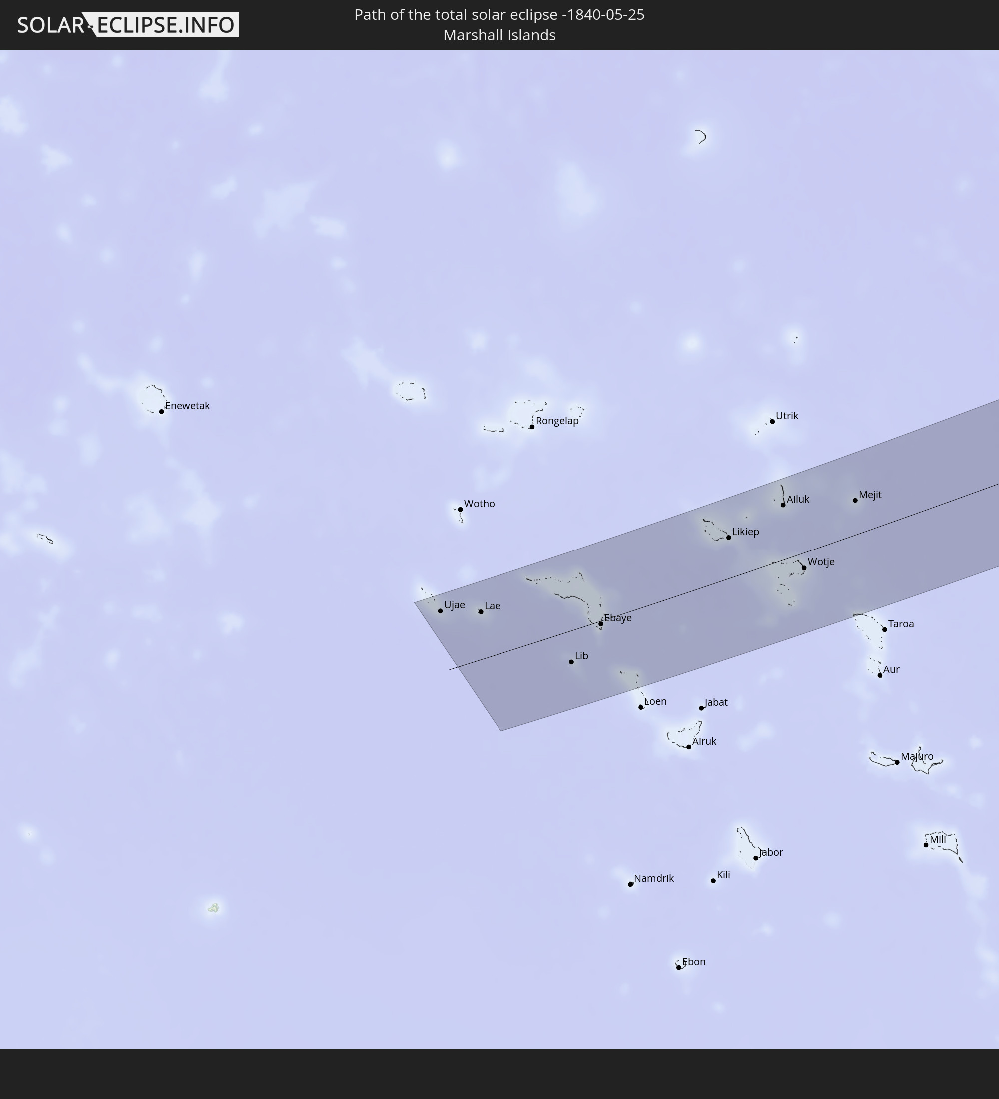 Marshall Islands
In den folgenden Ländern ist die Sonnenfinsternis partiell zu sehen
 Fiji
Fiji
 Russia
 United States
 United States Minor Outlying Islands
 Wallis and Futuna
 Tonga
Tonga
 Kiribati
 Samoa
Samoa
 Tokelau
 American Samoa
 Cook Islands
 Canada
 Mexico
 Greenland
 Guatemala
 El Salvador
 Honduras
 Belize
 Nicaragua
 Costa Rica
 Cuba
Cuba
 Panama
 Colombia
 Cayman Islands
 The Bahamas
 Jamaica
 Haiti
Haiti
 Brazil
 Venezuela
 Turks and Caicos Islands
 Dominican Republic
 Aruba
Aruba
 Puerto Rico
 United States Virgin Islands
 Bermuda
 British Virgin Islands
 Anguilla
 Collectivity of Saint Martin
 Saint Barthélemy
 Saint Kitts and Nevis
 Antigua and Barbuda
 Montserrat
 Trinidad and Tobago
 Guadeloupe
 Grenada
 Dominica
 Saint Vincent and the Grenadines
 Guyana
 Martinique
 Saint Lucia
 Barbados
 Saint Pierre and Miquelon
 Iceland
 Japan
Japan
 Marshall Islands
 Tuvalu
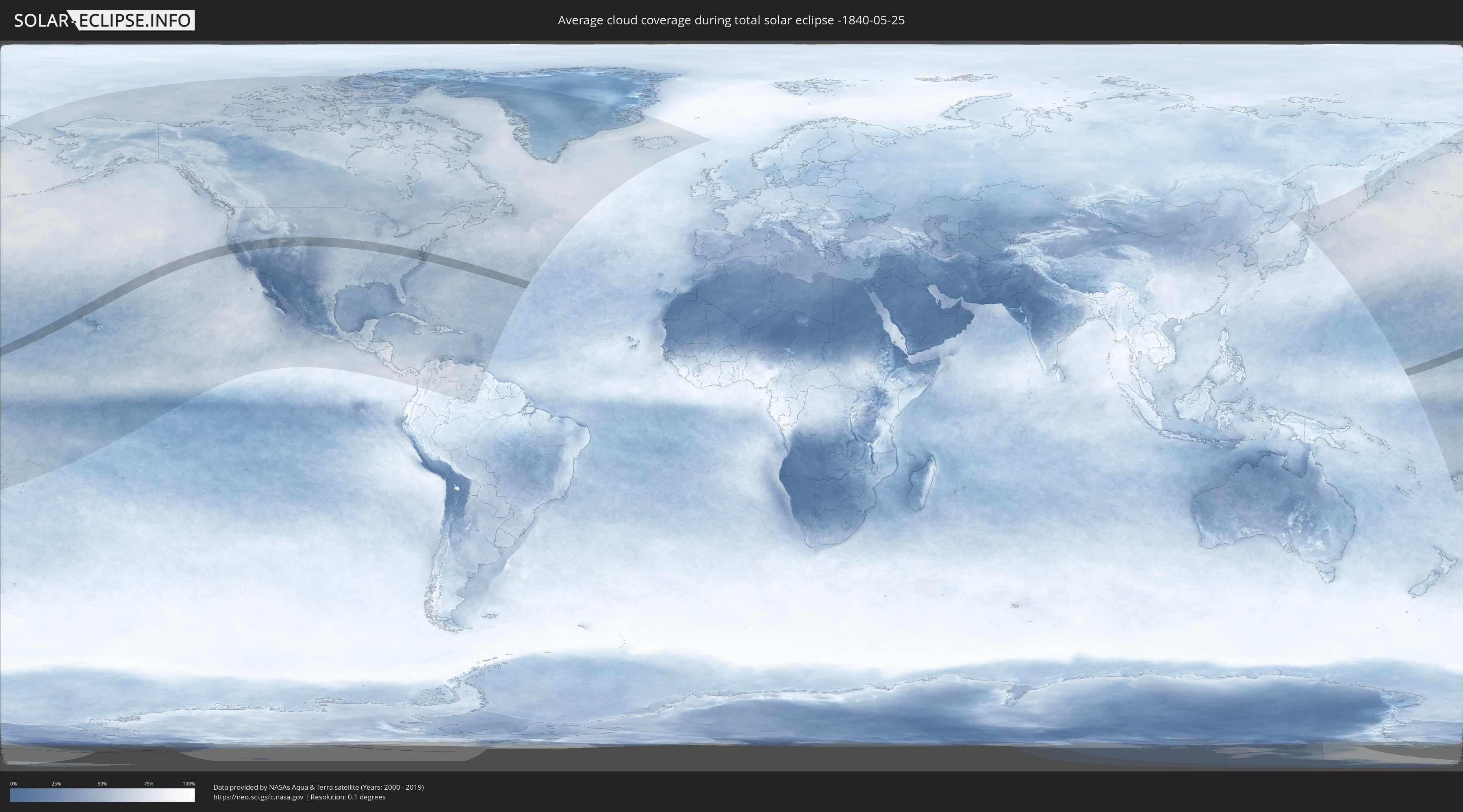
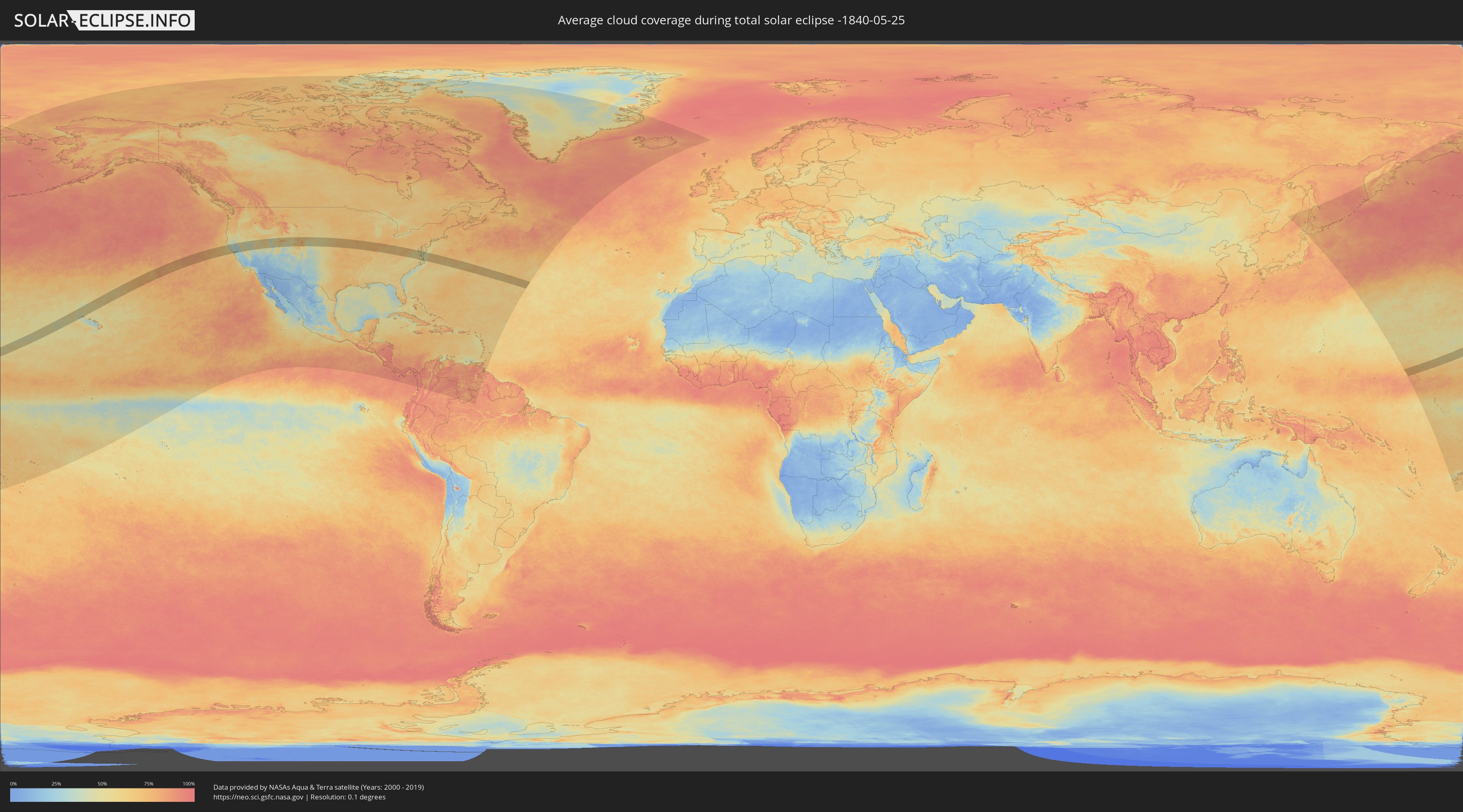
How will be the weather during the total solar eclipse on 05/25/-1840?
Where is the best place to see the total solar eclipse of 05/25/-1840?
The following maps show the average cloud coverage for the day of the total solar eclipse.
With the help of these maps, it is possible to find the place along the eclipse path, which has the best
chance of a cloudless sky.
Nevertheless, you should consider local circumstances and inform about the weather of your chosen
observation site.
The data is provided by NASAs satellites
AQUA and TERRA.
The cloud maps are averaged over a period of 19 years (2000 - 2019).
Detailed country maps
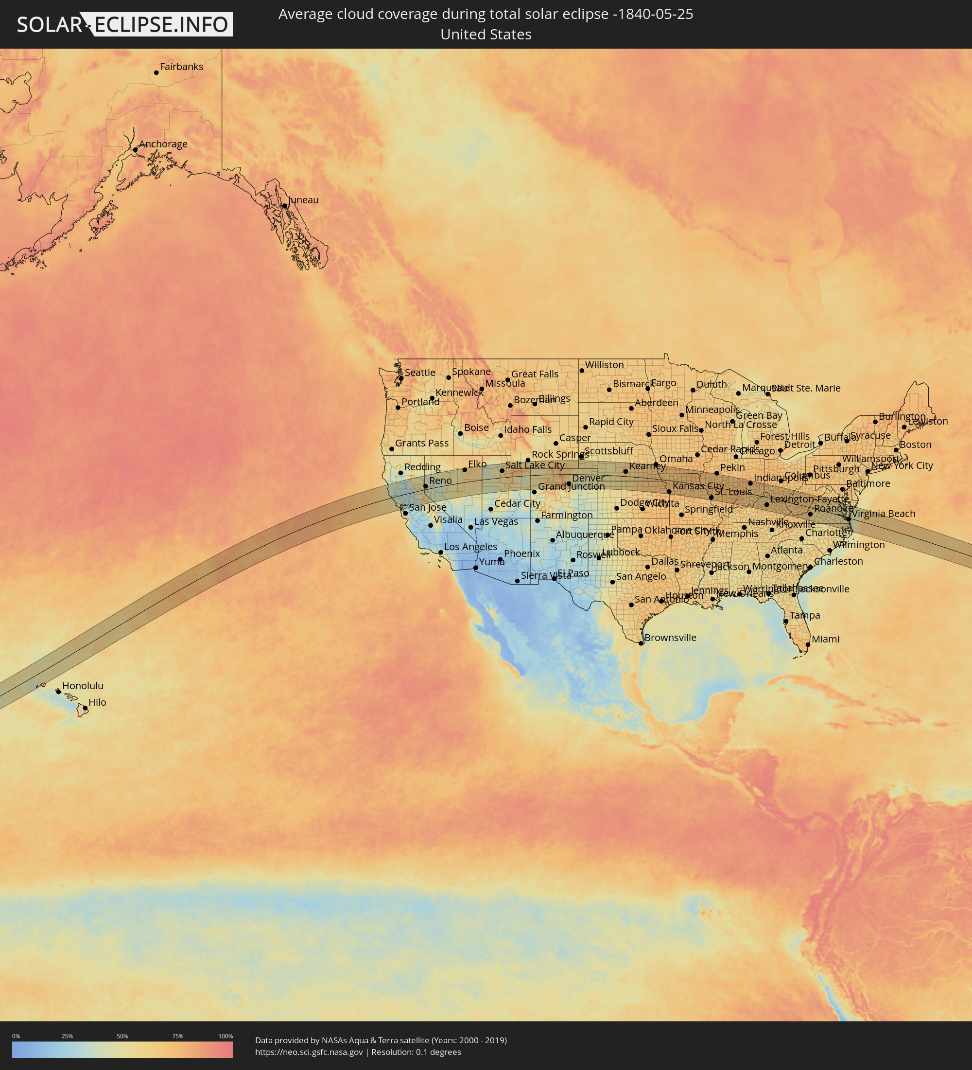 United States
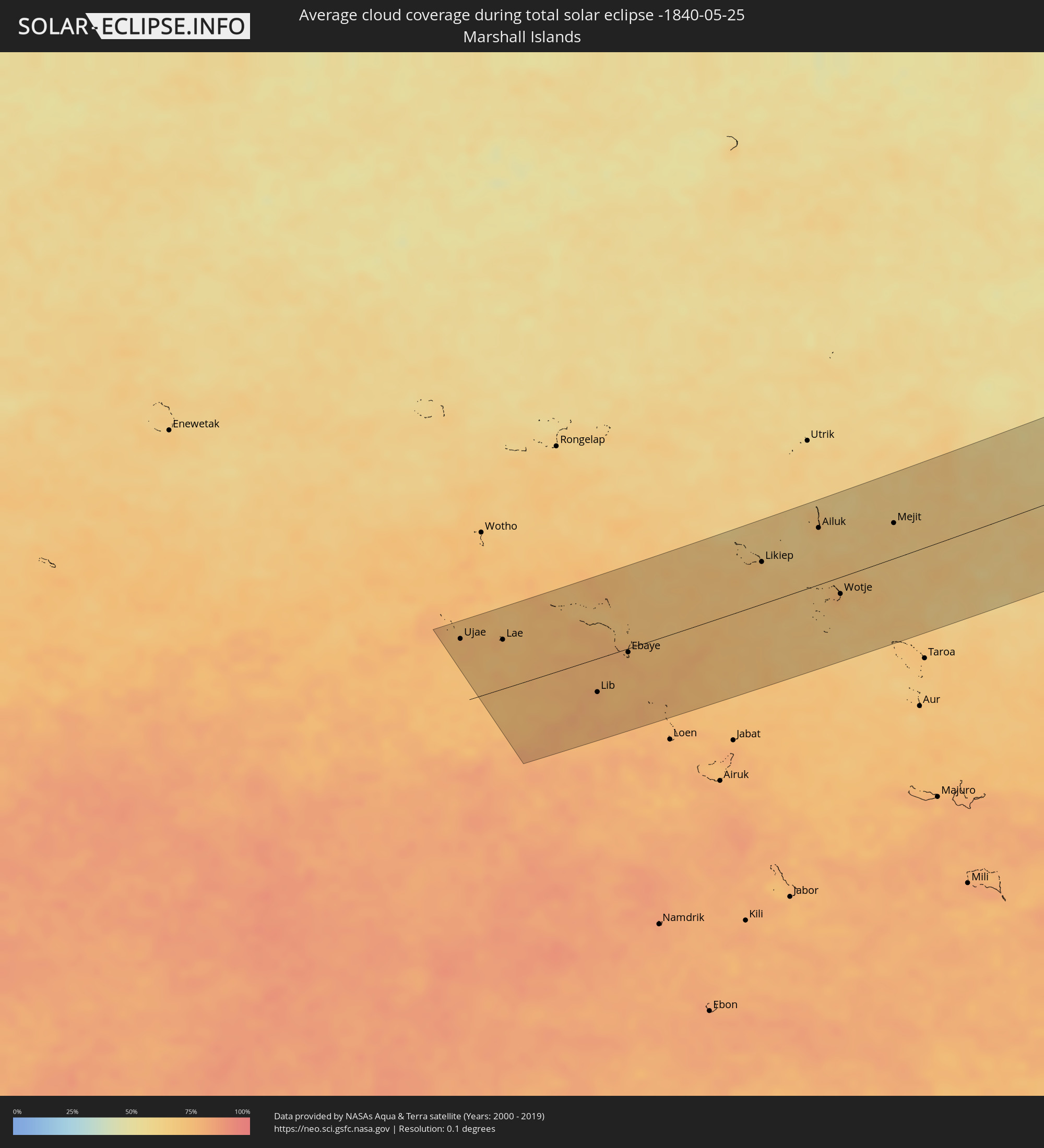 Marshall Islands
Cities inside the path of the eclipse
The following table shows all locations with a population of more than 5,000 inside the eclipse path. Cities which have more than 100,000 inhabitants are marked bold. A click at the locations opens a detailed map.
| City | Type | Eclipse duration | Local time of max. eclipse | Distance to central line | Ø Cloud coverage |
|
Santa Rosa, California
|
total | - | 12:31:37 UTC-08:00 | 38 km | 42% |
|
Petaluma, California
|
total | - | 12:31:41 UTC-08:00 | 62 km | 41% |
|
Novato, California
|
total | - | 12:31:46 UTC-08:00 | 77 km | 38% |
|
San Rafael, California
|
total | - | 12:31:47 UTC-08:00 | 92 km | 37% |
|
San Francisco, California
|
total | - | 12:31:55 UTC-08:00 | 116 km | 51% |
|
Napa, California
|
total | - | 12:32:27 UTC-08:00 | 63 km | 39% |
|
Berkeley, California
|
total | - | 12:32:17 UTC-08:00 | 109 km | 46% |
|
Vallejo, California
|
total | - | 12:32:25 UTC-08:00 | 84 km | 35% |
|
Fairfield, California
|
total | - | 12:32:57 UTC-08:00 | 73 km | 30% |
|
Concord, California
|
total | - | 12:32:50 UTC-08:00 | 103 km | 33% |
|
Danville, California
|
total | - | 12:32:50 UTC-08:00 | 120 km | 41% |
|
Chico, California
|
total | - | 12:34:00 UTC-08:00 | 83 km | 30% |
|
Antioch, California
|
total | - | 12:33:20 UTC-08:00 | 104 km | 27% |
|
Woodland, California
|
total | - | 12:33:42 UTC-08:00 | 32 km | 32% |
|
Davis, California
|
total | - | 12:33:42 UTC-08:00 | 47 km | 33% |
|
Yuba City, California
|
total | - | 12:34:13 UTC-08:00 | 14 km | 34% |
|
Sacramento, California
|
total | - | 12:34:14 UTC-08:00 | 49 km | 34% |
|
Elk Grove, California
|
total | - | 12:34:25 UTC-08:00 | 70 km | 32% |
|
Rancho Cordova, California
|
total | - | 12:34:38 UTC-08:00 | 52 km | 33% |
|
Lincoln, California
|
total | - | 12:34:47 UTC-08:00 | 19 km | 32% |
|
Stockton, California
|
total | - | 12:34:24 UTC-08:00 | 120 km | 28% |
|
Roseville, California
|
total | - | 12:34:44 UTC-08:00 | 34 km | 32% |
|
Lodi, California
|
total | - | 12:34:30 UTC-08:00 | 102 km | 31% |
|
El Dorado Hills, California
|
total | - | 12:35:08 UTC-08:00 | 46 km | 34% |
|
Reno, Nevada
|
total | - | 12:38:01 UTC-08:00 | 22 km | 43% |
|
Carson City, Nevada
|
total | - | 12:38:00 UTC-08:00 | 18 km | 42% |
|
Tooele, Utah
|
total | - | 13:52:43 UTC-07:00 | 33 km | 61% |
|
Ogden, Utah
|
total | - | 13:53:13 UTC-07:00 | 107 km | 52% |
|
Layton, Utah
|
total | - | 13:53:15 UTC-07:00 | 89 km | 49% |
|
West Jordan, Utah
|
total | - | 13:53:22 UTC-07:00 | 39 km | 52% |
|
Salt Lake City, Utah
|
total | - | 13:53:26 UTC-07:00 | 55 km | 50% |
|
Lehi, Utah
|
total | - | 13:53:34 UTC-07:00 | 14 km | 50% |
|
Provo, Utah
|
total | - | 13:53:57 UTC-07:00 | 5 km | 50% |
|
Laramie, Wyoming
|
total | - | 14:04:12 UTC-07:00 | 89 km | 64% |
|
Boulder, Colorado
|
total | - | 14:05:18 UTC-07:00 | 56 km | 66% |
|
Ken Caryl, Colorado
|
total | - | 14:05:46 UTC-07:00 | 105 km | 60% |
|
Longmont, Colorado
|
total | - | 14:05:31 UTC-07:00 | 39 km | 57% |
|
Broomfield, Colorado
|
total | - | 14:05:39 UTC-07:00 | 67 km | 60% |
|
Fort Collins, Colorado
|
total | - | 14:05:21 UTC-07:00 | 7 km | 62% |
|
Loveland, Colorado
|
total | - | 14:05:27 UTC-07:00 | 13 km | 58% |
|
Denver, Colorado
|
total | - | 14:05:54 UTC-07:00 | 87 km | 56% |
|
Centennial, Colorado
|
total | - | 14:06:09 UTC-07:00 | 105 km | 54% |
|
Brighton, Colorado
|
total | - | 14:06:04 UTC-07:00 | 59 km | 50% |
|
Cheyenne, Wyoming
|
total | - | 14:05:31 UTC-07:00 | 69 km | 65% |
|
Greeley, Colorado
|
total | - | 14:06:02 UTC-07:00 | 11 km | 51% |
|
Kearney, Nebraska
|
total | - | 15:14:30 UTC-06:00 | 38 km | 59% |
|
Grand Island, Nebraska
|
total | - | 15:15:23 UTC-06:00 | 67 km | 65% |
|
Lincoln, Nebraska
|
total | - | 15:17:44 UTC-06:00 | 66 km | 67% |
|
Manhattan, Kansas
|
total | - | 15:19:05 UTC-06:00 | 112 km | 69% |
|
Bellevue, Nebraska
|
total | - | 15:18:30 UTC-06:00 | 110 km | 66% |
|
Leavenworth, Kansas
|
total | - | 15:21:11 UTC-06:00 | 83 km | 69% |
|
Saint Joseph, Missouri
|
total | - | 15:20:55 UTC-06:00 | 31 km | 71% |
|
Overland Park, Kansas
|
total | - | 15:21:46 UTC-06:00 | 116 km | 75% |
|
Kansas City, Missouri
|
total | - | 15:21:47 UTC-06:00 | 102 km | 74% |
|
Liberty, Missouri
|
total | - | 15:21:53 UTC-06:00 | 85 km | 71% |
|
East Independence, Missouri
|
total | - | 15:22:05 UTC-06:00 | 100 km | 72% |
|
Columbia, Missouri
|
total | - | 15:24:42 UTC-06:00 | 93 km | 69% |
|
Quincy, Illinois
|
total | - | 15:24:56 UTC-06:00 | 27 km | 70% |
|
O'Fallon, Missouri
|
total | - | 15:26:43 UTC-06:00 | 87 km | 68% |
|
Chesterfield, Missouri
|
total | - | 15:26:59 UTC-06:00 | 102 km | 65% |
|
Saint Charles, Missouri
|
total | - | 15:27:00 UTC-06:00 | 87 km | 67% |
|
Mehlville, Missouri
|
total | - | 15:27:25 UTC-06:00 | 115 km | 69% |
|
St. Louis, Missouri
|
total | - | 15:27:27 UTC-06:00 | 100 km | 71% |
|
Upper Alton, Illinois
|
total | - | 15:27:15 UTC-06:00 | 68 km | 68% |
|
Belleville, Illinois
|
total | - | 15:27:47 UTC-06:00 | 109 km | 73% |
|
Springfield, Illinois
|
total | - | 15:27:00 UTC-06:00 | 37 km | 70% |
|
Decatur, Illinois
|
total | - | 15:27:42 UTC-06:00 | 51 km | 73% |
|
Champaign, Illinois
|
total | - | 15:28:10 UTC-06:00 | 92 km | 72% |
|
Danville, Illinois
|
total | - | 15:28:46 UTC-06:00 | 103 km | 70% |
|
Terre Haute, Indiana
|
total | - | 16:29:36 UTC-05:00 | 34 km | 71% |
|
Bloomington, Indiana
|
total | - | 16:30:45 UTC-05:00 | 16 km | 66% |
|
Indianapolis, Indiana
|
total | - | 16:30:31 UTC-05:00 | 88 km | 70% |
|
Carmel, Indiana
|
total | - | 16:30:21 UTC-05:00 | 112 km | 69% |
|
Greenwood, Indiana
|
total | - | 16:30:43 UTC-05:00 | 72 km | 71% |
|
Columbus, Indiana
|
total | - | 16:31:17 UTC-05:00 | 31 km | 70% |
|
Louisville, Kentucky
|
total | - | 16:32:20 UTC-05:00 | 70 km | 63% |
|
Florence, Kentucky
|
total | - | 16:32:39 UTC-05:00 | 32 km | 67% |
|
Nicholasville, Kentucky
|
total | - | 16:33:46 UTC-05:00 | 89 km | 66% |
|
Hamilton, Ohio
|
total | - | 16:32:19 UTC-05:00 | 77 km | 68% |
|
Georgetown, Kentucky
|
total | - | 16:33:28 UTC-05:00 | 53 km | 67% |
|
Lexington-Fayette, Kentucky
|
total | - | 16:33:43 UTC-05:00 | 68 km | 68% |
|
Cincinnati, Ohio
|
total | - | 16:32:39 UTC-05:00 | 53 km | 69% |
|
Middletown, Ohio
|
total | - | 16:32:21 UTC-05:00 | 92 km | 66% |
|
Mason, Ohio
|
total | - | 16:32:35 UTC-05:00 | 77 km | 67% |
|
Richmond, Kentucky
|
total | - | 16:34:09 UTC-05:00 | 98 km | 67% |
|
Kettering, Ohio
|
total | - | 16:32:23 UTC-05:00 | 115 km | 69% |
|
Ironville, Kentucky
|
total | - | 16:34:49 UTC-05:00 | 10 km | 67% |
|
Huntington, West Virginia
|
total | - | 16:35:03 UTC-05:00 | 11 km | 63% |
|
Charleston, West Virginia
|
total | - | 16:35:46 UTC-05:00 | 20 km | 62% |
|
Blacksburg, Virginia
|
total | - | 16:37:46 UTC-05:00 | 76 km | 67% |
|
Roanoke, Virginia
|
total | - | 16:38:04 UTC-05:00 | 61 km | 64% |
|
Lynchburg, Virginia
|
total | - | 16:38:29 UTC-05:00 | 28 km | 59% |
|
Harrisonburg, Virginia
|
total | - | 16:37:39 UTC-05:00 | 89 km | 68% |
|
Charlottesville, Virginia
|
total | - | 16:38:19 UTC-05:00 | 53 km | 62% |
|
Richmond, Virginia
|
total | - | 16:39:27 UTC-05:00 | 25 km | 60% |
|
Petersburg, Virginia
|
total | - | 16:39:48 UTC-05:00 | 9 km | 56% |
|
Suffolk, Virginia
|
total | - | 16:40:47 UTC-05:00 | 43 km | 56% |
|
Newport News, Virginia
|
total | - | 16:40:30 UTC-05:00 | 2 km | 53% |
|
Norfolk, Virginia
|
total | - | 16:40:51 UTC-05:00 | 23 km | 55% |
|
Virginia Beach, Virginia
|
total | - | 16:41:01 UTC-05:00 | 15 km | 46% |
|
Ujae, Ujae Atoll
|
total | - | 05:36:42 UTC+11:00 | 78 km | 74% |
|
Lae, Lae Atoll
|
total | - | 05:36:35 UTC+11:00 | 61 km | 72% |
|
Lib, Lib Island
|
total | - | 05:35:54 UTC+11:00 | 42 km | 77% |
|
Ebaye, Kwajalein Atoll
|
total | - | 05:36:11 UTC+11:00 | 5 km | 78% |
|
Likiep, Likiep Atoll
|
total | - | 05:36:46 UTC+11:00 | 51 km | 68% |
|
Ailuk, Ailuk Atoll
|
total | - | 05:37:00 UTC+11:00 | 69 km | 65% |
|
Wotje, Wotje Atoll
|
total | - | 05:36:21 UTC+11:00 | 21 km | 76% |
|
Mejit, Mejit Island
|
total | - | 05:36:58 UTC+11:00 | 43 km | 68% |