Total solar eclipse of 08/16/-1891
| Day of week: | Wednesday |
| Maximum duration of eclipse: | 03m57s |
| Maximum width of eclipse path: | 175 km |
| Saros cycle: | 5 |
| Coverage: | 100% |
| Magnitude: | 1.0412 |
| Gamma: | -0.6177 |
Wo kann man die Sonnenfinsternis vom 08/16/-1891 sehen?
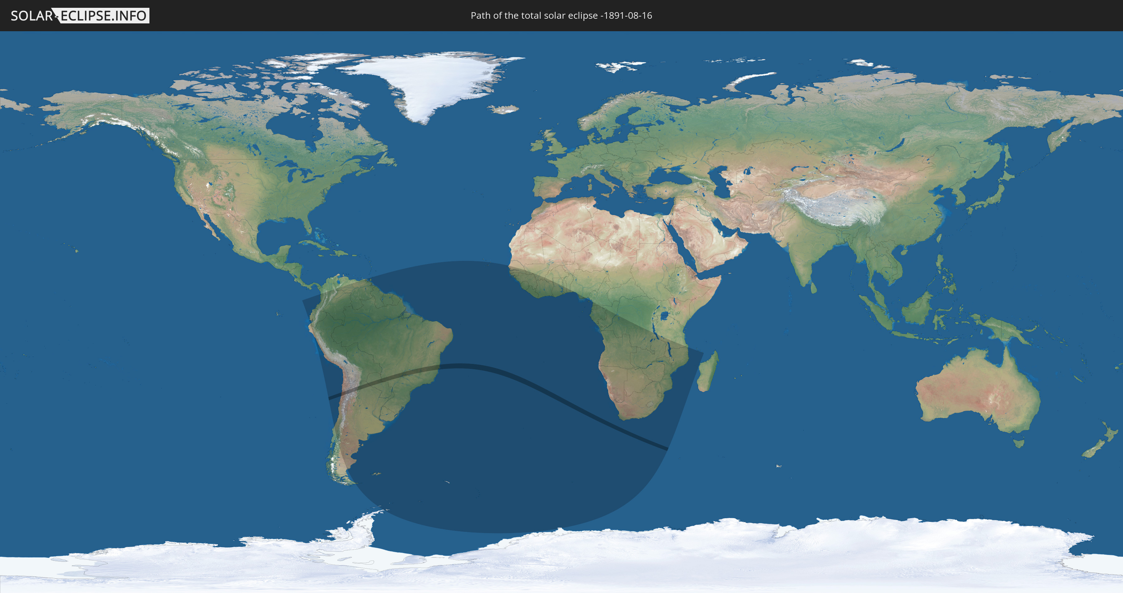
Die Sonnenfinsternis am 08/16/-1891 kann man in 53 Ländern als partielle Sonnenfinsternis beobachten.
Der Finsternispfad verläuft durch 4 Länder. Nur in diesen Ländern ist sie als total Sonnenfinsternis zu sehen.
In den folgenden Ländern ist die Sonnenfinsternis total zu sehen
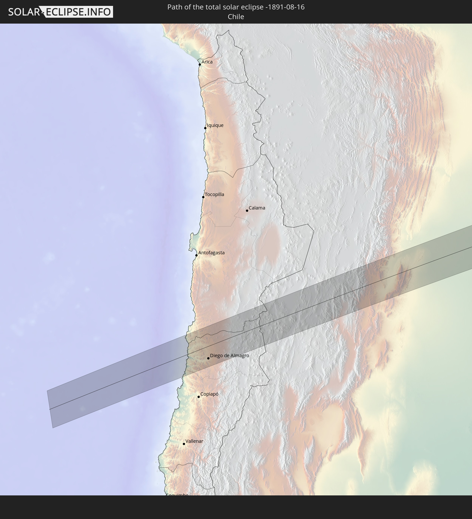 Chile
Chile
 Brazil
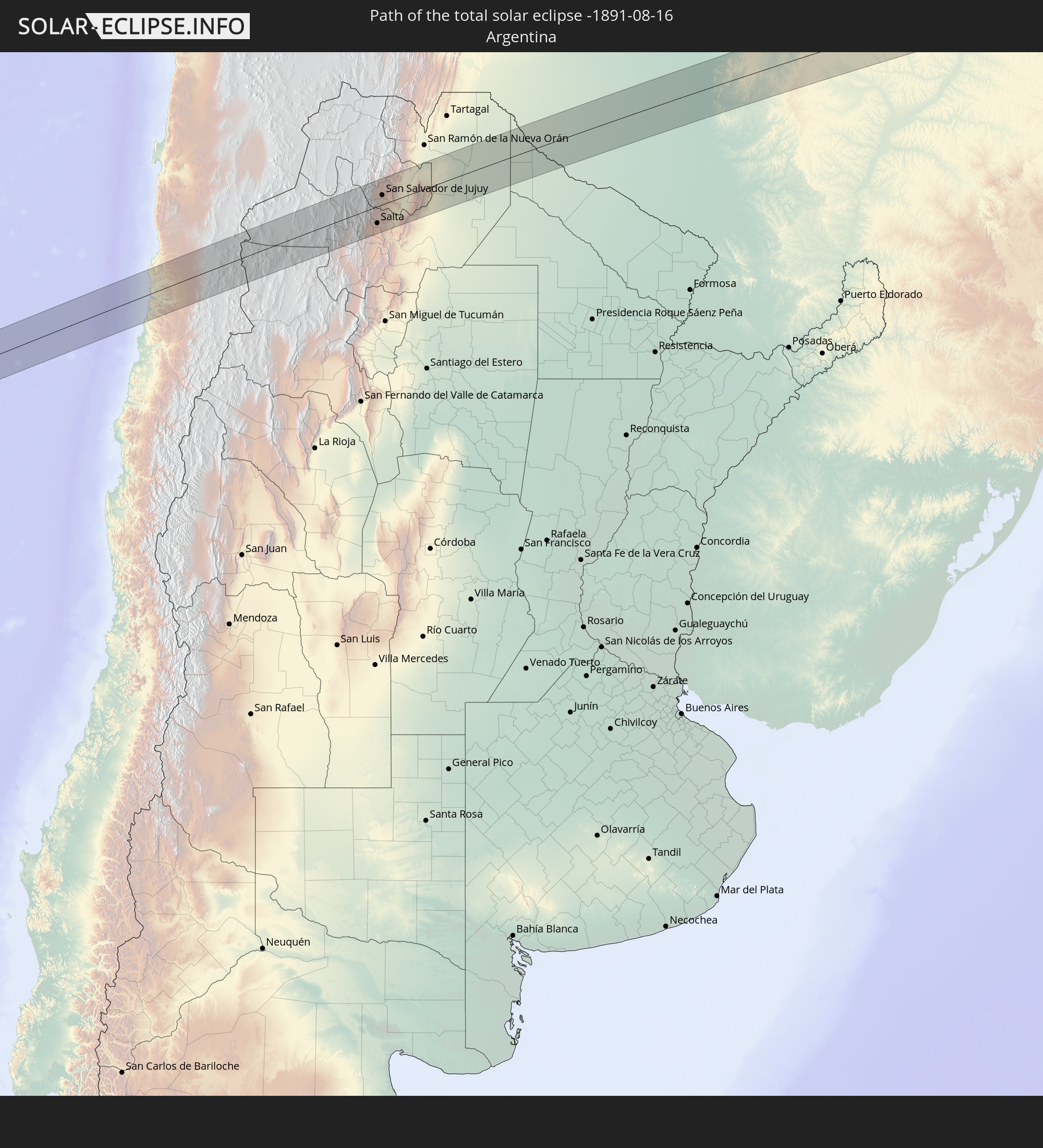 Argentina
 Paraguay
In den folgenden Ländern ist die Sonnenfinsternis partiell zu sehen
 Antarctica
 Chile
Chile
 Ecuador
 Colombia
 Peru
Peru
 Brazil
 Argentina
 Venezuela
 Bolivia
 Paraguay
 Trinidad and Tobago
 Falkland Islands
 Guyana
 Uruguay
 Suriname
 French Guiana
 South Georgia and the South Sandwich Islands
 Cabo Verde
 Senegal
 The Gambia
 Guinea-Bissau
 Guinea
 Saint Helena, Ascension and Tristan da Cunha
 Sierra Leone
 Mali
Mali
 Liberia
 Ivory Coast
 Burkina Faso
 Ghana
Ghana
 Togo
Togo
 Benin
Benin
 Nigeria
 Bouvet Island
 Equatorial Guinea
 São Tomé and Príncipe
 Cameroon
 Gabon
Gabon
 Republic of the Congo
 Angola
 Namibia
 Democratic Republic of the Congo
 South Africa
 Botswana
 Zambia
 Zimbabwe
 Lesotho
 Tanzania
 Mozambique
 Swaziland
 Malawi
 French Southern and Antarctic Lands
 Comoros
 Mayotte
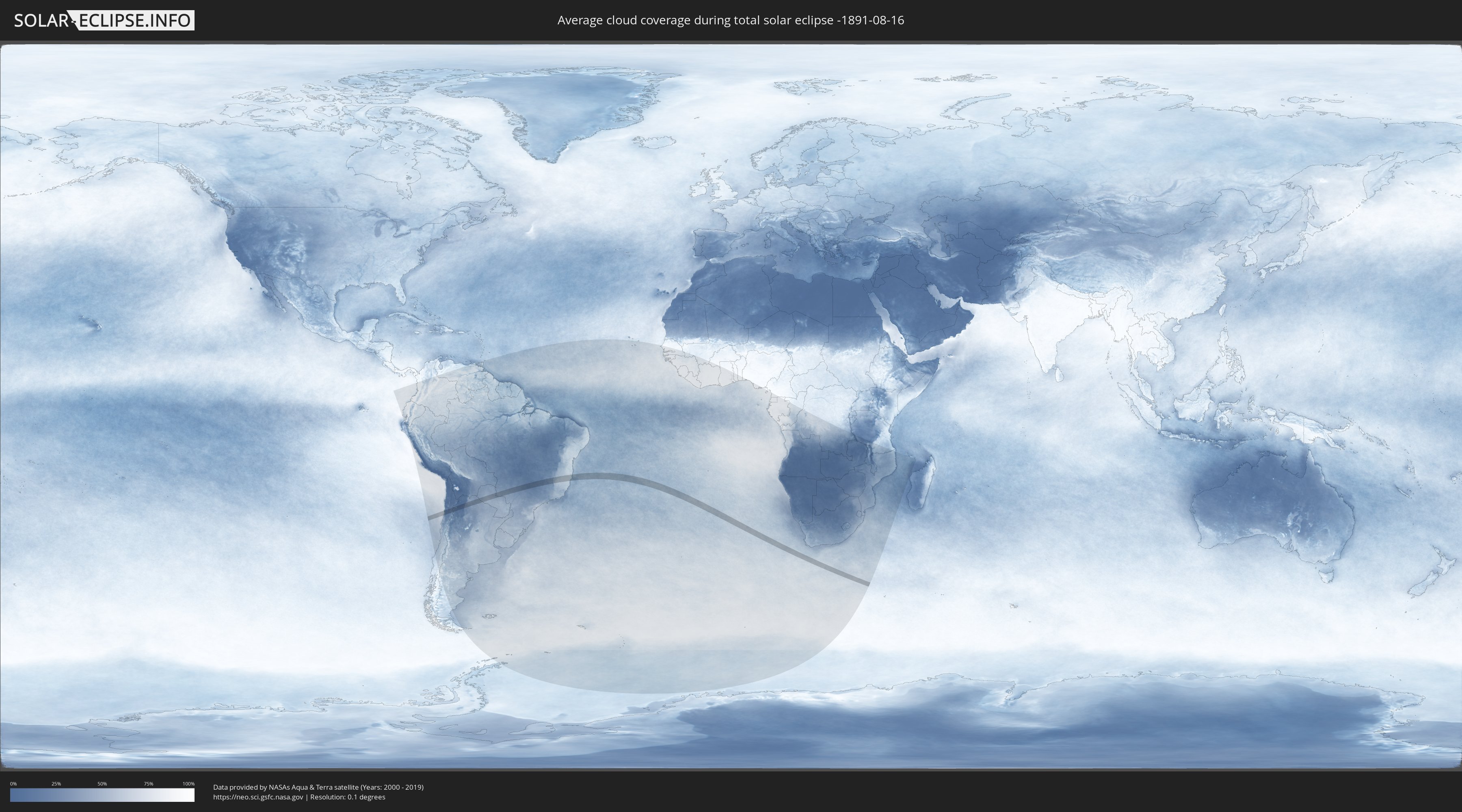
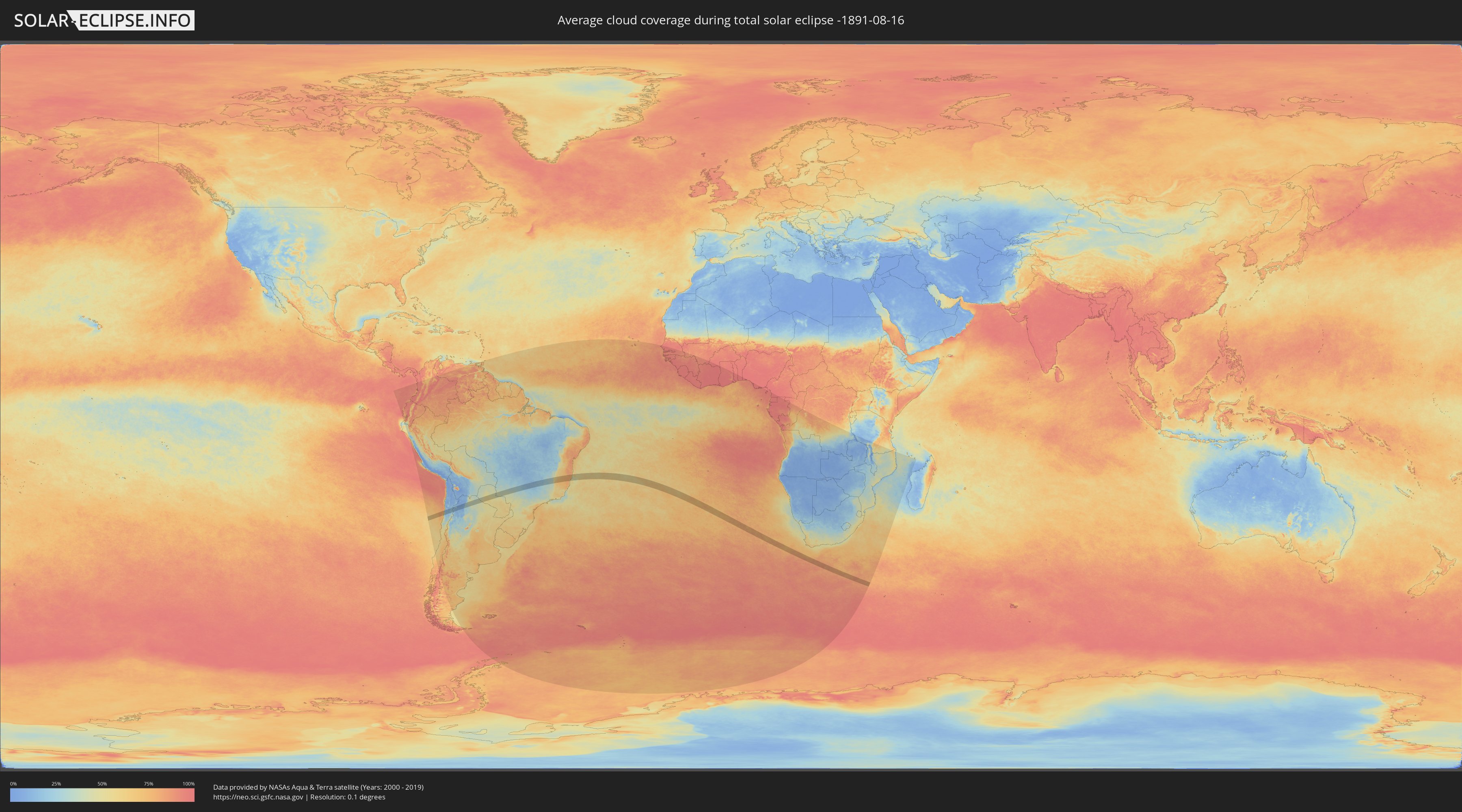
How will be the weather during the total solar eclipse on 08/16/-1891?
Where is the best place to see the total solar eclipse of 08/16/-1891?
The following maps show the average cloud coverage for the day of the total solar eclipse.
With the help of these maps, it is possible to find the place along the eclipse path, which has the best
chance of a cloudless sky.
Nevertheless, you should consider local circumstances and inform about the weather of your chosen
observation site.
The data is provided by NASAs satellites
AQUA and TERRA.
The cloud maps are averaged over a period of 19 years (2000 - 2019).
Detailed country maps
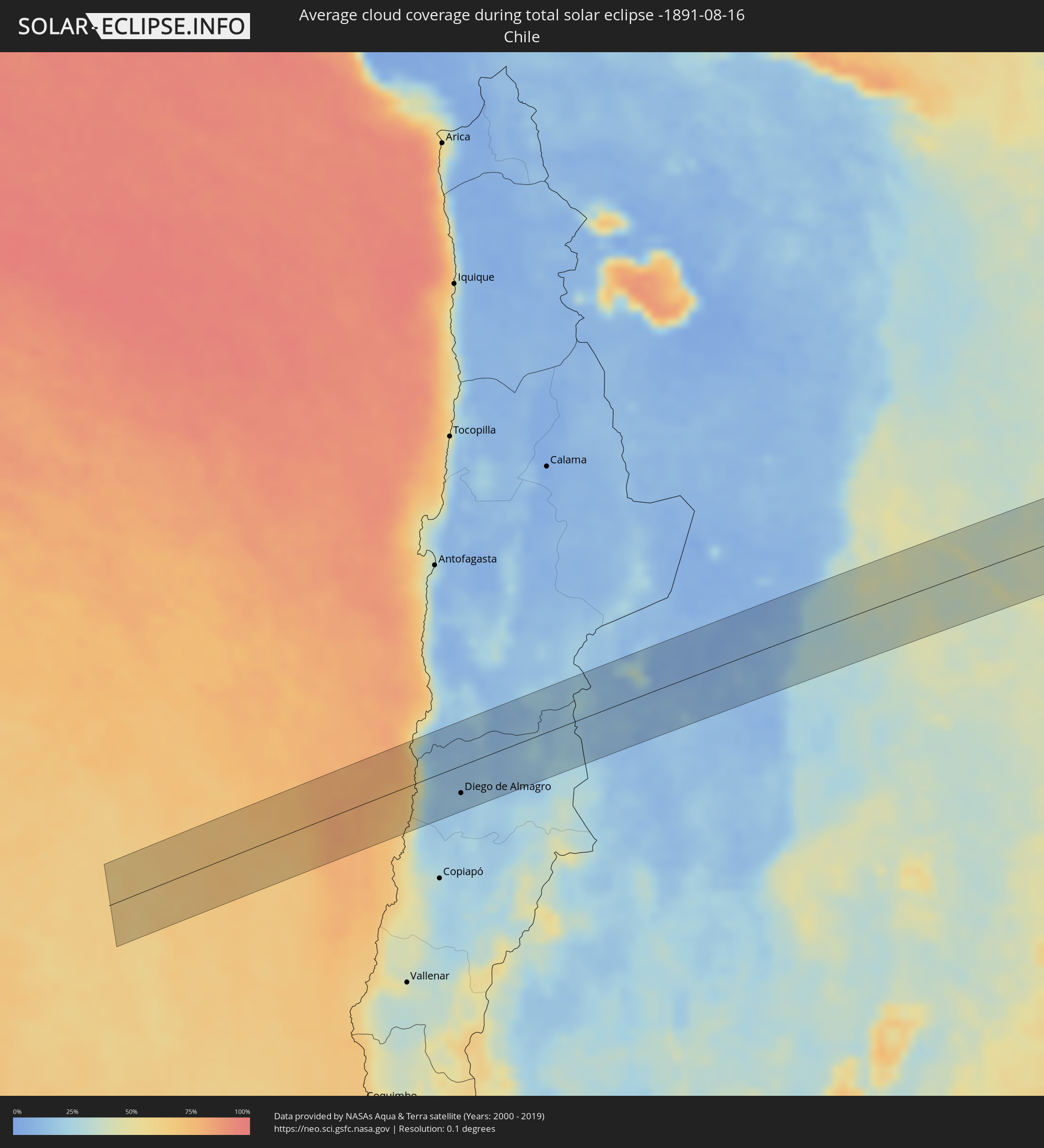 Chile
Chile
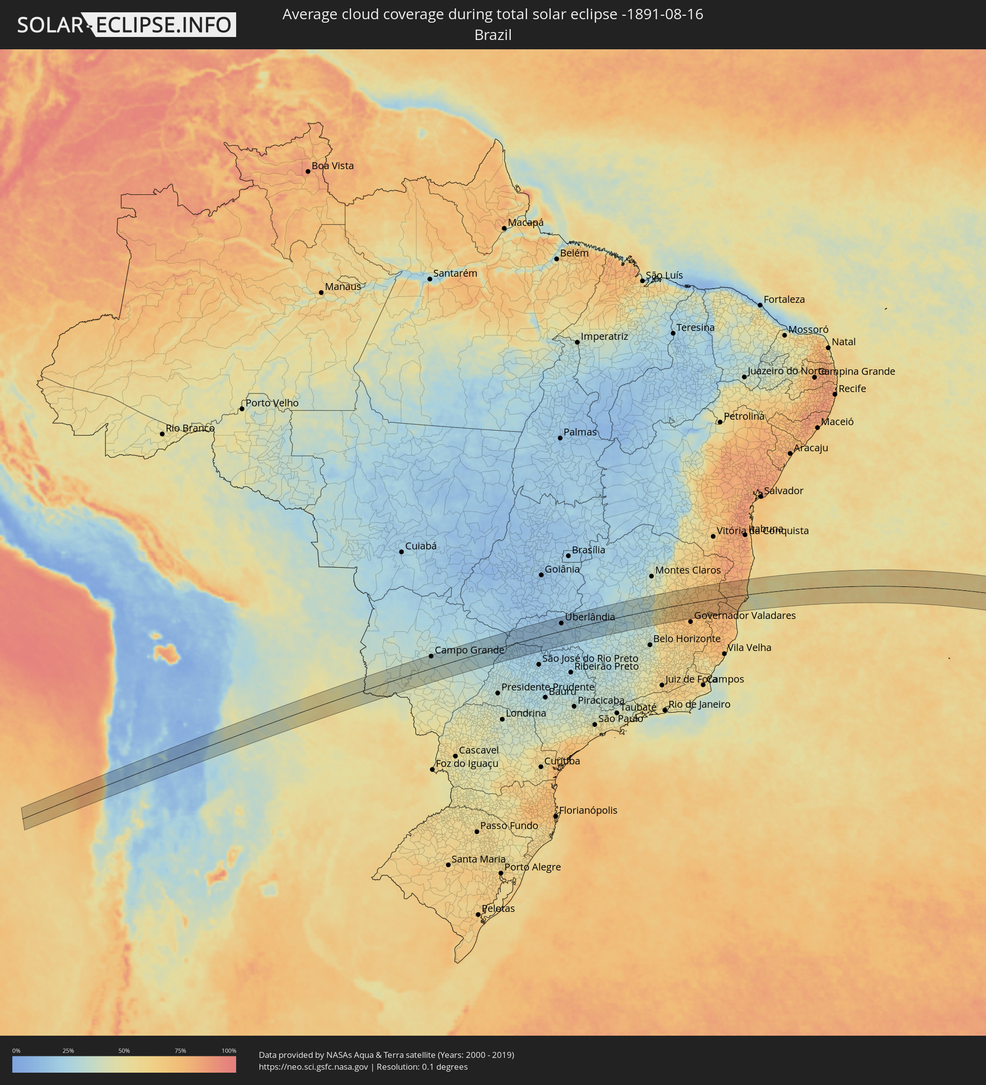 Brazil
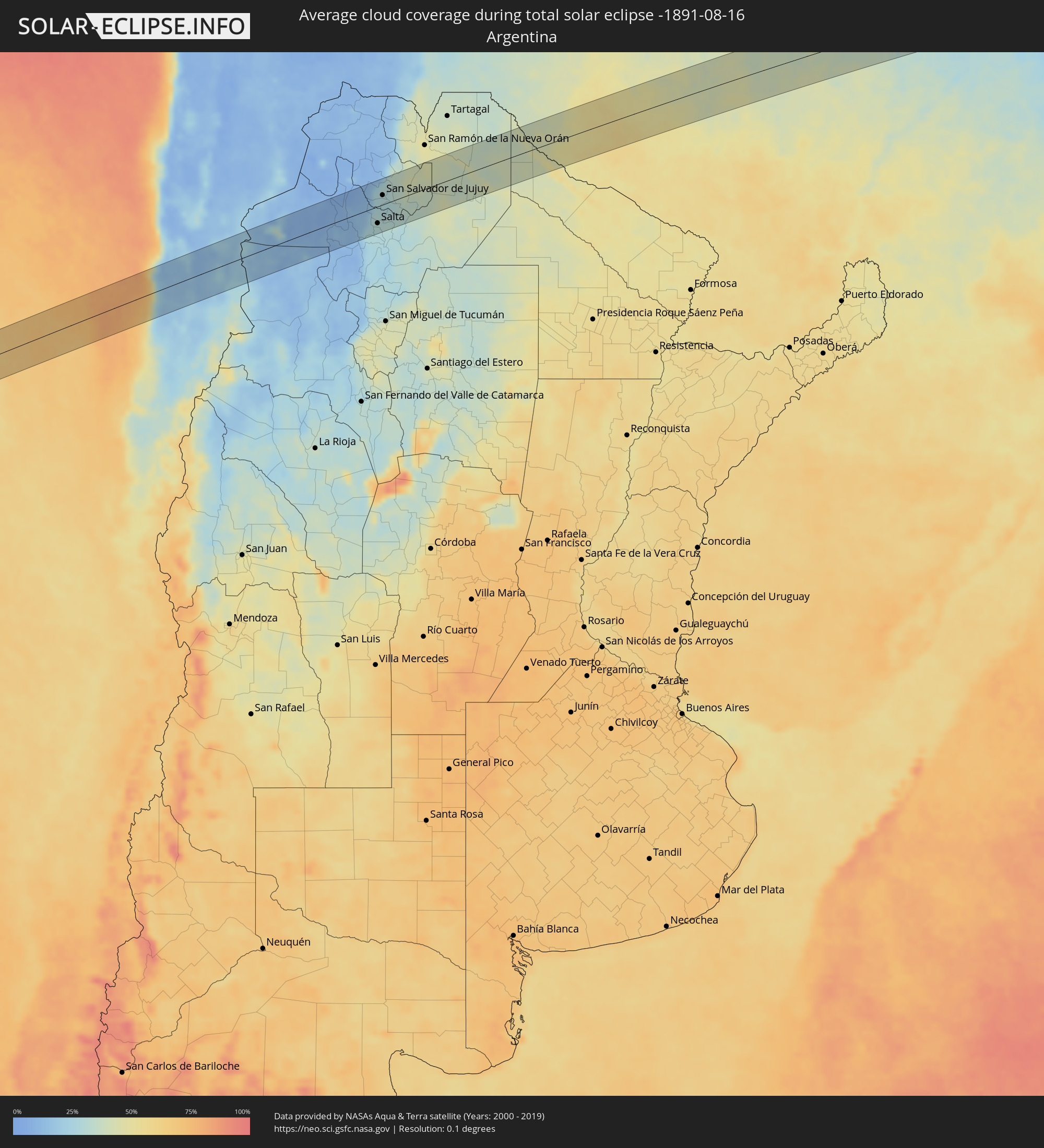 Argentina
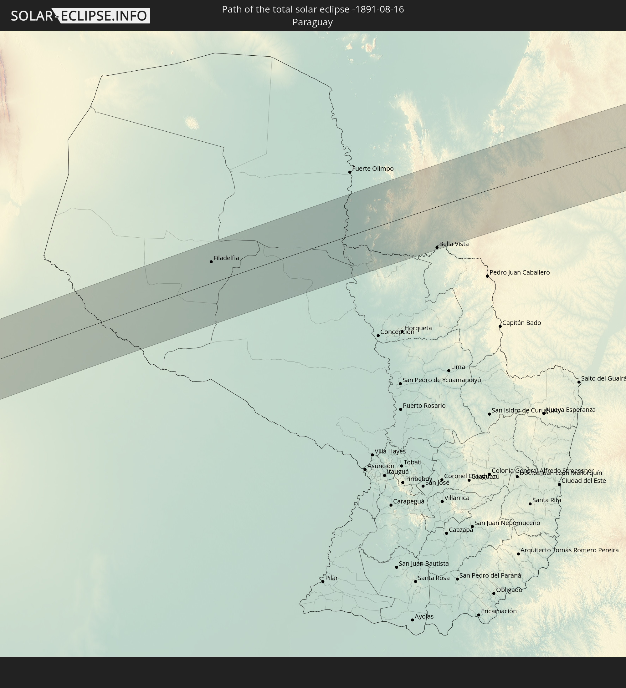
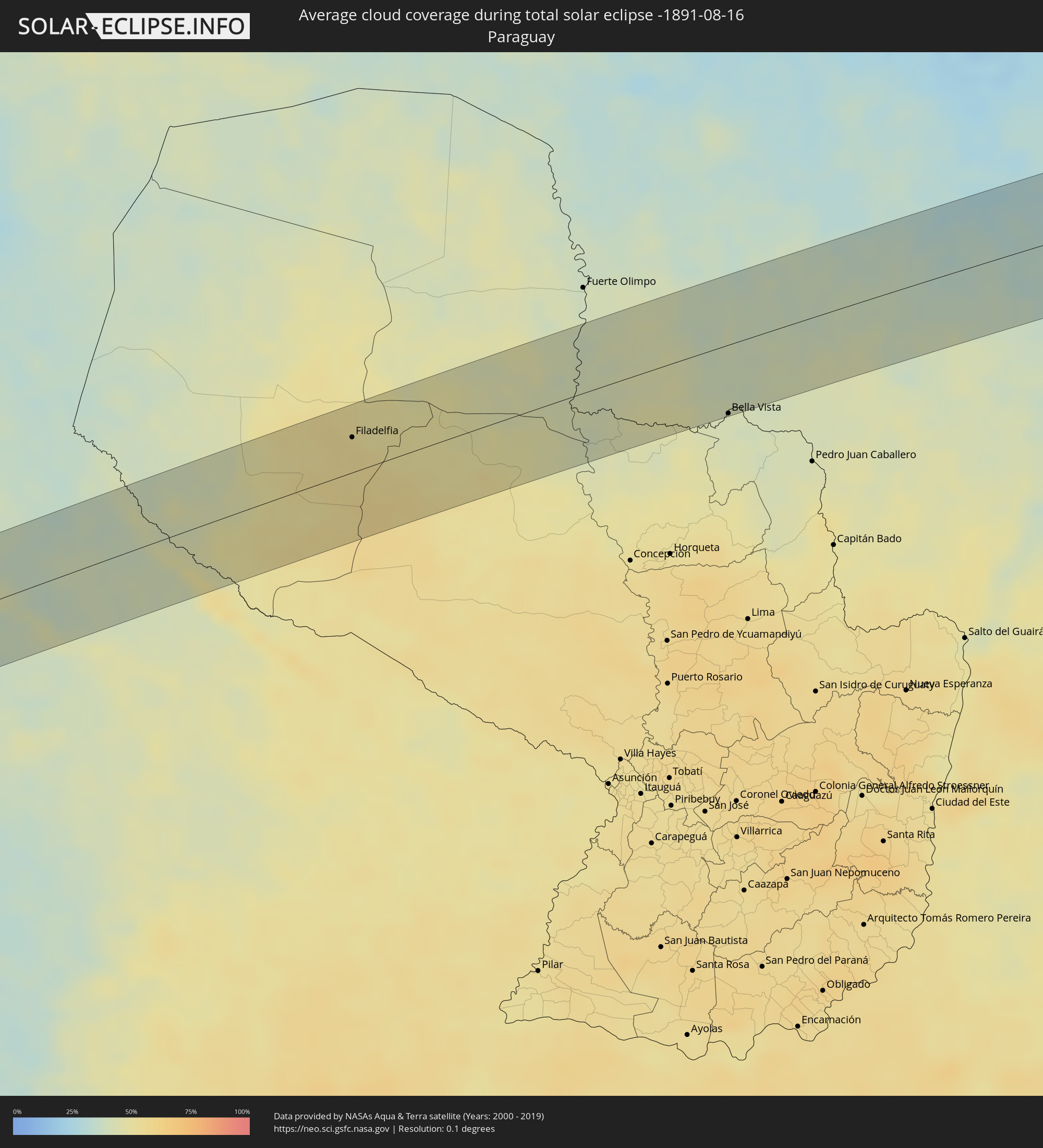 Paraguay
Cities inside the path of the eclipse
The following table shows all locations with a population of more than 5,000 inside the eclipse path. Cities which have more than 100,000 inhabitants are marked bold. A click at the locations opens a detailed map.
| City | Type | Eclipse duration | Local time of max. eclipse | Distance to central line | Ø Cloud coverage |
|
Diego de Almagro, Atacama
|
total | - | 07:01:51 UTC-04:42 | 34 km | 18% |
|
Salta, Salta Province
|
total | - | 07:29:11 UTC-04:16 | 37 km | 29% |
|
San Salvador de Jujuy, Jujuy Province
|
total | - | 07:28:44 UTC-04:16 | 21 km | 29% |
|
Palpalá, Jujuy Province
|
total | - | 07:28:51 UTC-04:16 | 11 km | 27% |
|
San Pedro, Jujuy Province
|
total | - | 07:29:04 UTC-04:16 | 2 km | 34% |
|
Ingenio La Esperanza, Jujuy Province
|
total | - | 07:29:05 UTC-04:16 | 1 km | 37% |
|
Fraile Pintado, Jujuy Province
|
total | - | 07:28:52 UTC-04:16 | 30 km | 39% |
|
Libertador General San Martín, Jujuy Province
|
total | - | 07:28:45 UTC-04:16 | 43 km | 42% |
|
Calilegua, Jujuy Province
|
total | - | 07:28:44 UTC-04:16 | 46 km | 42% |
|
Caimancito, Jujuy Province
|
total | - | 07:28:50 UTC-04:16 | 43 km | 43% |
|
Yuto, Jujuy Province
|
total | - | 07:28:51 UTC-04:16 | 49 km | 40% |
|
Palma Sola, Jujuy Province
|
total | - | 07:29:15 UTC-04:16 | 10 km | 37% |
|
Apolinario Saravia, Salta Province
|
total | - | 07:29:54 UTC-04:16 | 50 km | 42% |
|
Filadelfia, Boquerón
|
total | - | 07:57:38 UTC-03:50 | 32 km | 53% |
|
Colonia Menno, Boquerón
|
total | - | 07:57:51 UTC-03:50 | 22 km | 53% |
|
Bela Vista, Mato Grosso do Sul
|
total | - | 08:01:08 UTC-03:50 | 60 km | 42% |
|
Bella Vista, Amambay
|
total | - | 08:01:09 UTC-03:50 | 63 km | 42% |
|
Bonito, Mato Grosso do Sul
|
total | - | 08:12:33 UTC-03:38 | 43 km | 40% |
|
Jardim, Mato Grosso do Sul
|
total | - | 08:13:15 UTC-03:38 | 6 km | 40% |
|
Maracaju, Mato Grosso do Sul
|
total | - | 08:14:31 UTC-03:38 | 51 km | 43% |
|
Sidrolândia, Mato Grosso do Sul
|
total | - | 08:14:13 UTC-03:38 | 15 km | 38% |
|
Campo Grande, Mato Grosso do Sul
|
total | - | 08:14:12 UTC-03:38 | 57 km | 30% |
|
Campo Verde, Mato Grosso do Sul
|
total | - | 08:14:55 UTC-03:38 | 42 km | 30% |
|
Três Lagoas, Mato Grosso do Sul
|
total | - | 08:18:26 UTC-03:38 | 69 km | 28% |
|
Ilha Solteira, São Paulo
|
total | - | 08:50:40 UTC-03:06 | 41 km | 22% |
|
Paranaíba, Mato Grosso do Sul
|
total | - | 08:18:17 UTC-03:38 | 35 km | 21% |
|
Aparecida do Taboado, Mato Grosso do Sul
|
total | - | 08:18:45 UTC-03:38 | 11 km | 20% |
|
Santa Fé do Sul, São Paulo
|
total | - | 08:51:06 UTC-03:06 | 29 km | 20% |
|
Jales, São Paulo
|
total | - | 08:51:43 UTC-03:06 | 46 km | 20% |
|
Fernandópolis, São Paulo
|
total | - | 08:52:11 UTC-03:06 | 56 km | 21% |
|
Iturama, Minas Gerais
|
total | - | 08:51:49 UTC-03:06 | 2 km | 15% |
|
Campina Verde, Minas Gerais
|
total | - | 08:52:46 UTC-03:06 | 3 km | 17% |
|
Ituiutaba, Minas Gerais
|
total | - | 08:52:22 UTC-03:06 | 63 km | 16% |
|
Frutal, Minas Gerais
|
total | - | 08:54:01 UTC-03:06 | 64 km | 18% |
|
Prata, Minas Gerais
|
total | - | 08:53:29 UTC-03:06 | 12 km | 18% |
|
Conceição das Alagoas, Minas Gerais
|
total | - | 08:54:50 UTC-03:06 | 67 km | 17% |
|
Uberlândia, Minas Gerais
|
total | - | 08:54:14 UTC-03:06 | 37 km | 18% |
|
Araguari, Minas Gerais
|
total | - | 08:54:11 UTC-03:06 | 64 km | 14% |
|
Uberaba, Minas Gerais
|
total | - | 08:55:27 UTC-03:06 | 61 km | 21% |
|
Monte Carmelo, Minas Gerais
|
total | - | 08:55:23 UTC-03:06 | 38 km | 20% |
|
Coromandel, Minas Gerais
|
total | - | 08:55:43 UTC-03:06 | 58 km | 21% |
|
Patrocínio, Minas Gerais
|
total | - | 08:56:26 UTC-03:06 | 2 km | 20% |
|
Araxá, Minas Gerais
|
total | - | 08:57:02 UTC-03:06 | 69 km | 25% |
|
Ibiá, Minas Gerais
|
total | - | 08:57:39 UTC-03:06 | 67 km | 25% |
|
Patos de Minas, Minas Gerais
|
total | - | 08:56:59 UTC-03:06 | 30 km | 20% |
|
Presidente Olegário, Minas Gerais
|
total | - | 08:57:02 UTC-03:06 | 45 km | 22% |
|
Carmo do Paranaíba, Minas Gerais
|
total | - | 08:57:40 UTC-03:06 | 20 km | 21% |
|
São Gotardo, Minas Gerais
|
total | - | 08:58:23 UTC-03:06 | 60 km | 30% |
|
Abaeté, Minas Gerais
|
total | - | 08:59:22 UTC-03:06 | 58 km | 28% |
|
Corinto, Minas Gerais
|
total | - | 09:00:37 UTC-03:06 | 5 km | 29% |
|
Curvelo, Minas Gerais
|
total | - | 09:00:58 UTC-03:06 | 37 km | 34% |
|
Diamantina, Minas Gerais
|
total | - | 09:02:10 UTC-03:06 | 1 km | 51% |
|
Guanhães, Minas Gerais
|
total | - | 09:03:55 UTC-03:06 | 70 km | 67% |
|
Itamarandiba, Minas Gerais
|
total | - | 09:03:22 UTC-03:06 | 29 km | 64% |
|
Capelinha, Minas Gerais
|
total | - | 09:03:56 UTC-03:06 | 41 km | 68% |
|
Itambacuri, Minas Gerais
|
total | - | 09:05:55 UTC-03:06 | 12 km | 74% |
|
Teófilo Otoni, Minas Gerais
|
total | - | 09:06:10 UTC-03:06 | 4 km | 74% |
|
Ecoporanga, Espírito Santo
|
total | - | 09:08:00 UTC-03:06 | 64 km | 77% |
|
Carlos Chagas, Minas Gerais
|
total | - | 09:07:37 UTC-03:06 | 9 km | 76% |
|
Nanuque, Minas Gerais
|
total | - | 09:08:38 UTC-03:06 | 12 km | 77% |
|
Itanhém, Bahia
|
total | - | 09:40:38 UTC-02:34 | 61 km | 76% |
|
Medeiros Neto, Bahia
|
total | - | 09:41:02 UTC-02:34 | 37 km | 76% |
|
Mucuri, Bahia
|
total | - | 09:43:04 UTC-02:34 | 52 km | 63% |
|
Itamaraju, Bahia
|
total | - | 09:42:19 UTC-02:34 | 64 km | 76% |
|
Nova Viçosa, Bahia
|
total | - | 09:43:19 UTC-02:34 | 33 km | 57% |
|
Prado, Bahia
|
total | - | 09:43:15 UTC-02:34 | 26 km | 54% |