Total solar eclipse of 11/16/-1951
| Day of week: | Sunday |
| Maximum duration of eclipse: | 01m44s |
| Maximum width of eclipse path: | 137 km |
| Saros cycle: | 21 |
| Coverage: | 100% |
| Magnitude: | 1.0211 |
| Gamma: | 0.852 |
Wo kann man die Sonnenfinsternis vom 11/16/-1951 sehen?
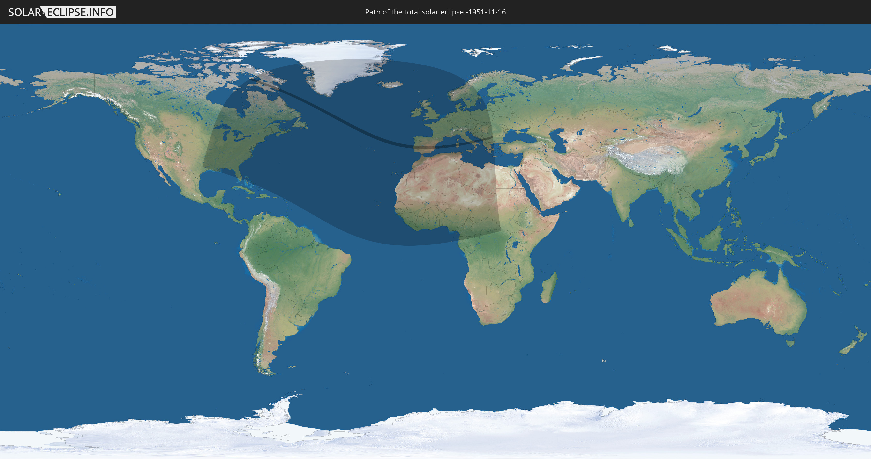
Die Sonnenfinsternis am 11/16/-1951 kann man in 83 Ländern als partielle Sonnenfinsternis beobachten.
Der Finsternispfad verläuft durch 8 Länder. Nur in diesen Ländern ist sie als total Sonnenfinsternis zu sehen.
In den folgenden Ländern ist die Sonnenfinsternis total zu sehen
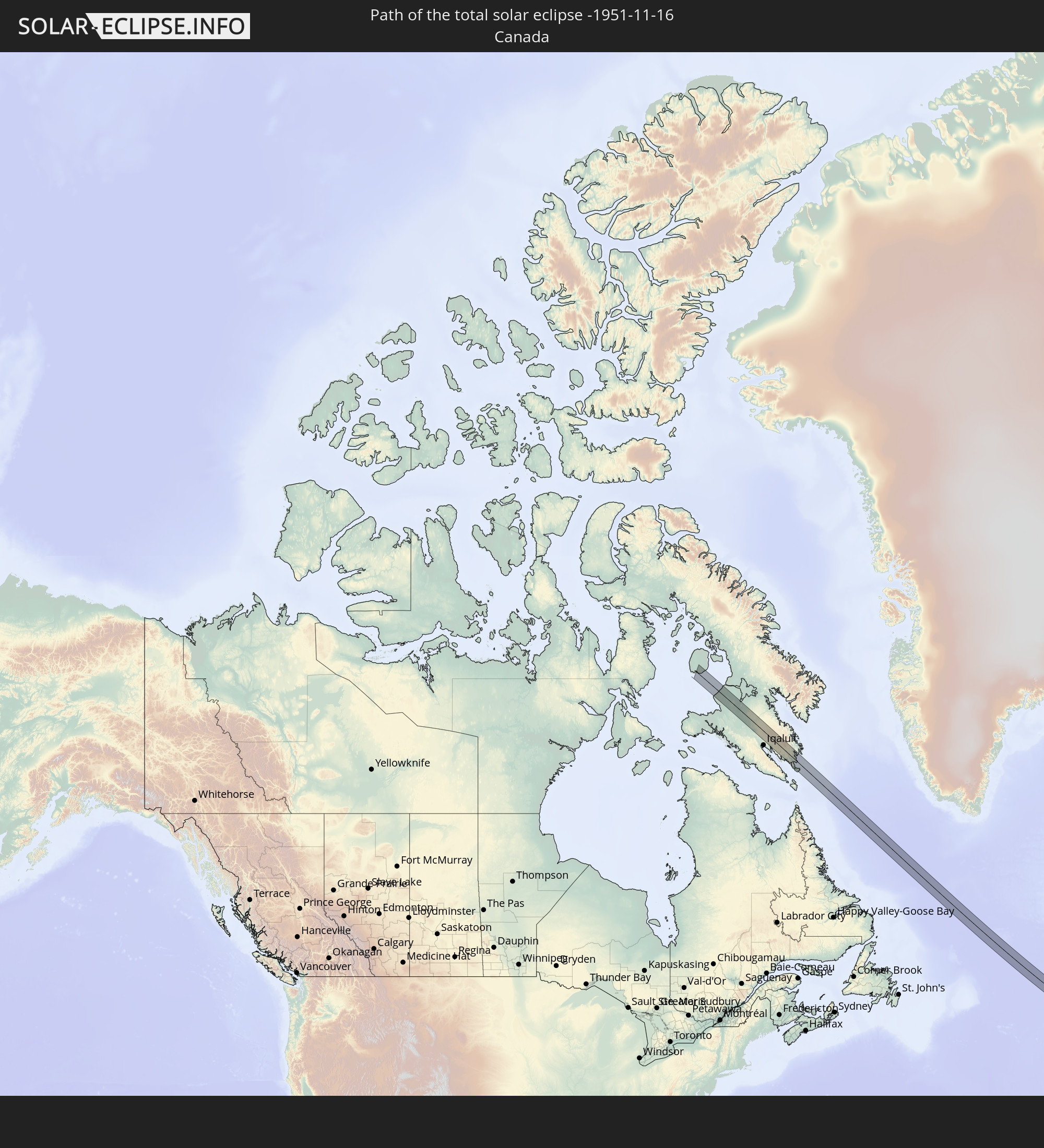 Canada
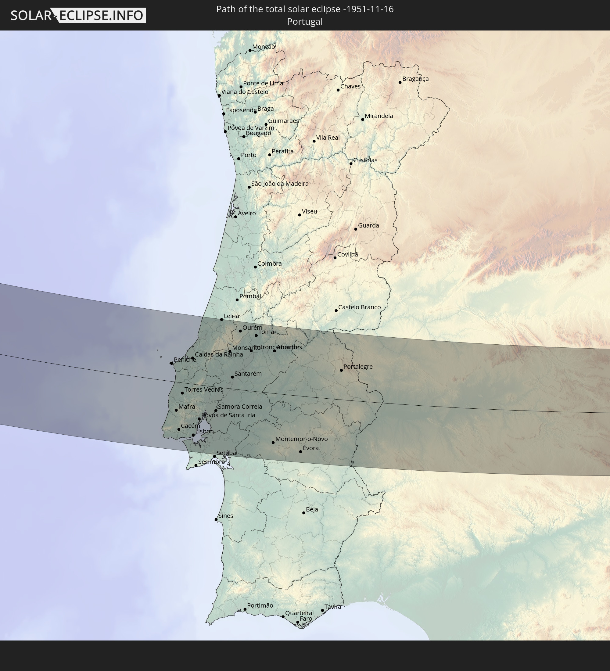 Portugal
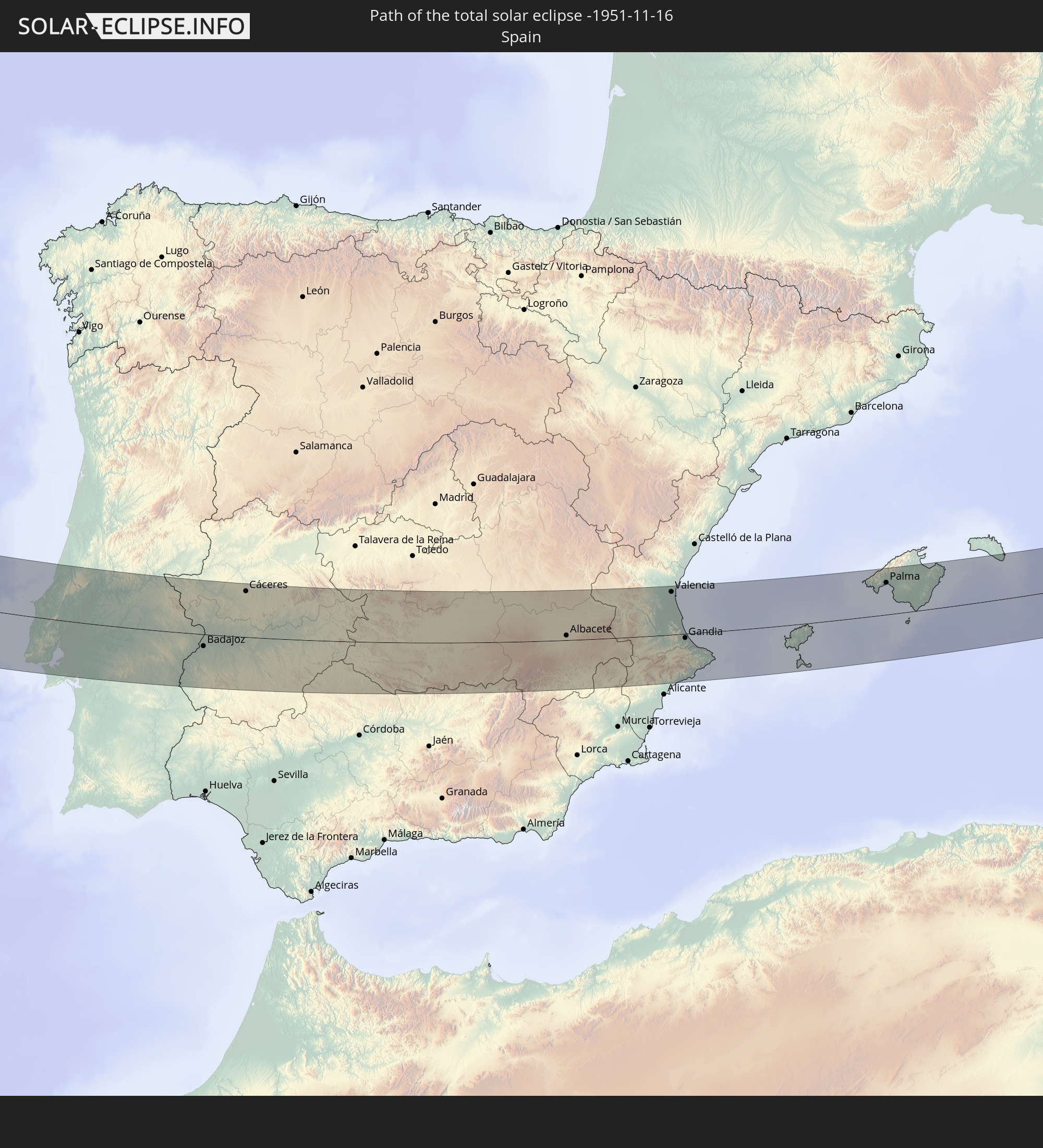 Spain
Spain
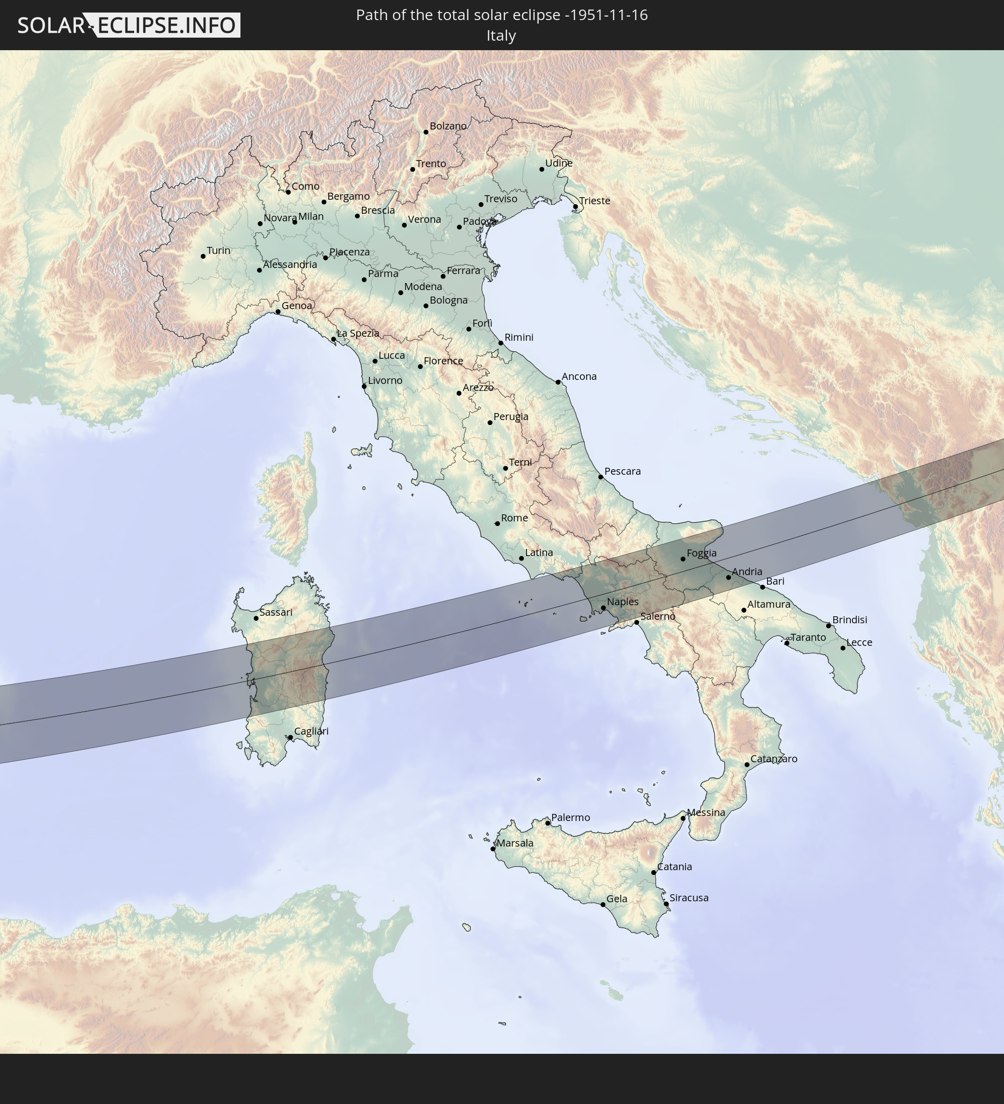 Italy
Italy
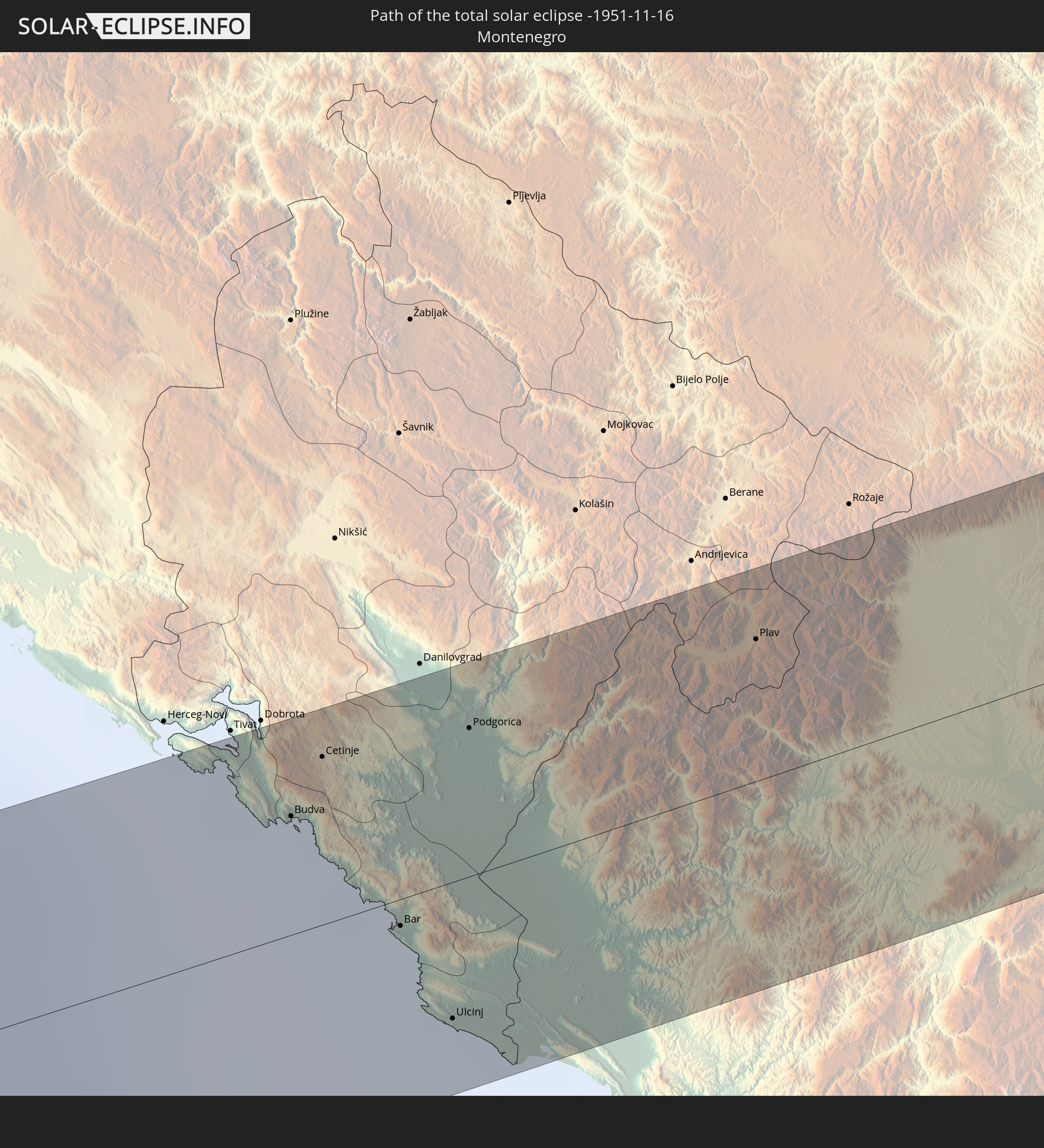 Montenegro
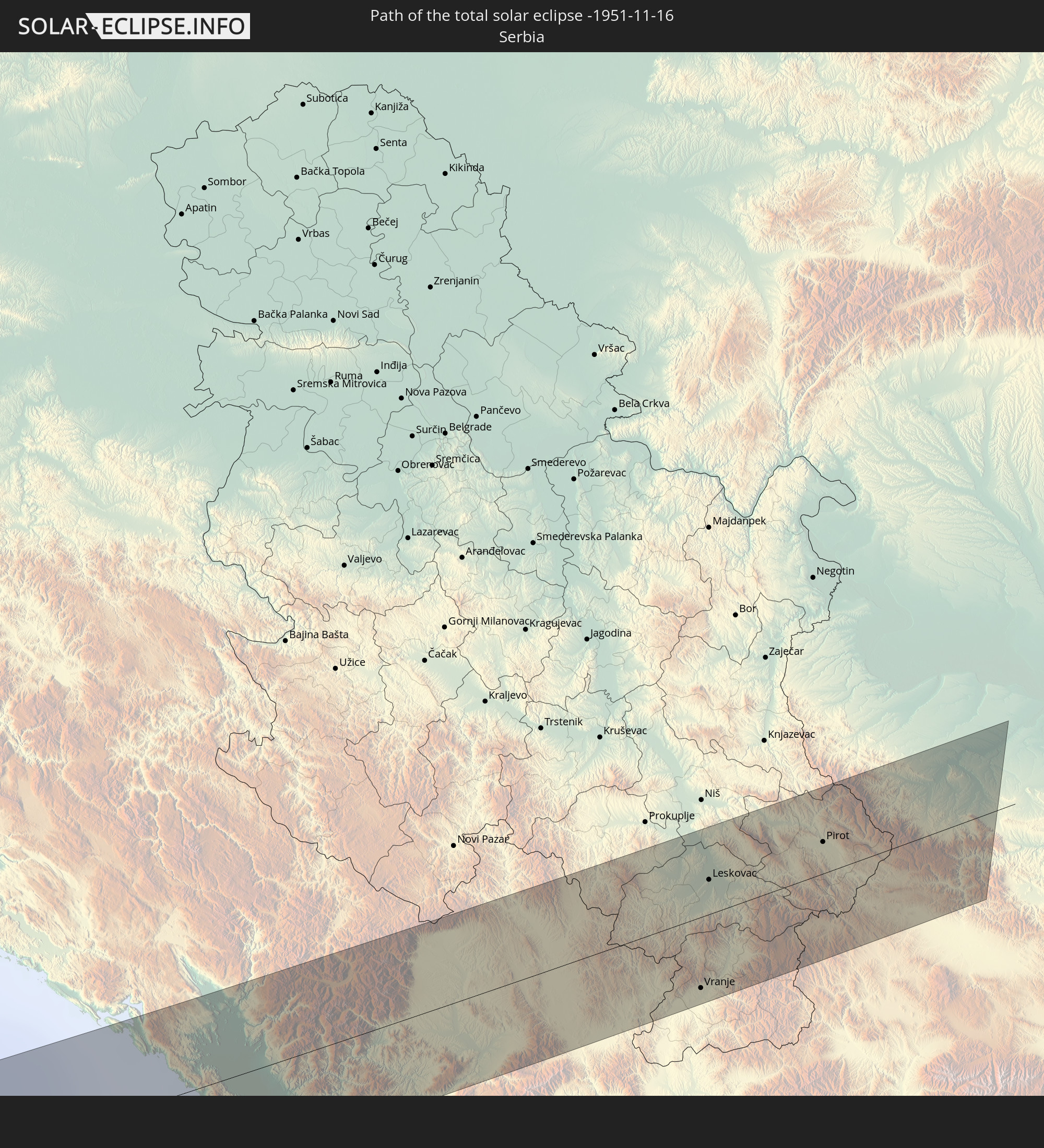 Serbia
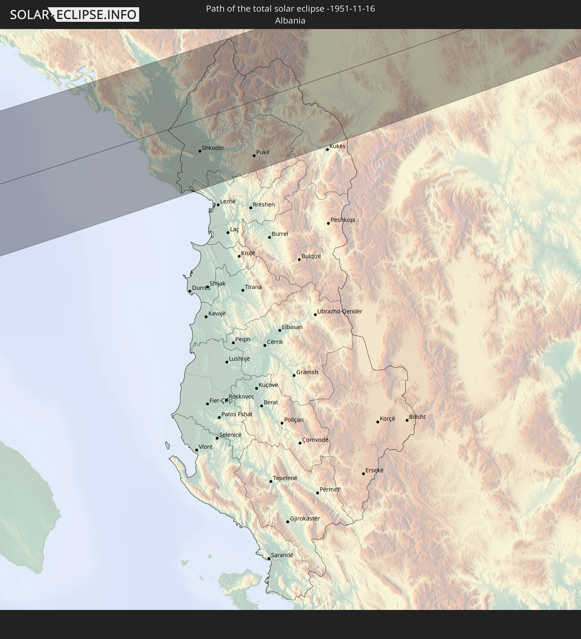 Albania
 Bulgaria
In den folgenden Ländern ist die Sonnenfinsternis partiell zu sehen
 Russia
 United States
 Canada
 Greenland
 The Bahamas
 Bermuda
 Anguilla
 Antigua and Barbuda
 Saint Pierre and Miquelon
 Portugal
 Cabo Verde
 Iceland
 Spain
Spain
 Senegal
 Mauritania
 The Gambia
 Guinea-Bissau
 Guinea
 Sierra Leone
 Morocco
 Mali
Mali
 Liberia
 Republic of Ireland
 Svalbard and Jan Mayen
 Algeria
 United Kingdom
 Ivory Coast
 Faroe Islands
 Burkina Faso
 Gibraltar
 France
 Isle of Man
 Ghana
Ghana
 Guernsey
 Jersey
 Togo
Togo
 Niger
Niger
 Benin
Benin
 Andorra
 Belgium
 Nigeria
 Netherlands
 Norway
 Equatorial Guinea
 Luxembourg
 Germany
 Switzerland
 São Tomé and Príncipe
 Italy
Italy
 Monaco
 Tunisia
 Denmark
 Cameroon
 Gabon
Gabon
 Libya
Libya
 Liechtenstein
 Austria
 Sweden
 Republic of the Congo
 Czechia
 Democratic Republic of the Congo
 San Marino
 Vatican City
 Slovenia
 Chad
Chad
 Croatia
 Poland
 Malta
Malta
 Central African Republic
 Bosnia and Herzegovina
 Hungary
 Slovakia
 Montenegro
 Serbia
 Albania
 Greece
 Romania
 Republic of Macedonia
 Lithuania
 Sudan
Sudan
 Ukraine
 Bulgaria
 Egypt
Egypt
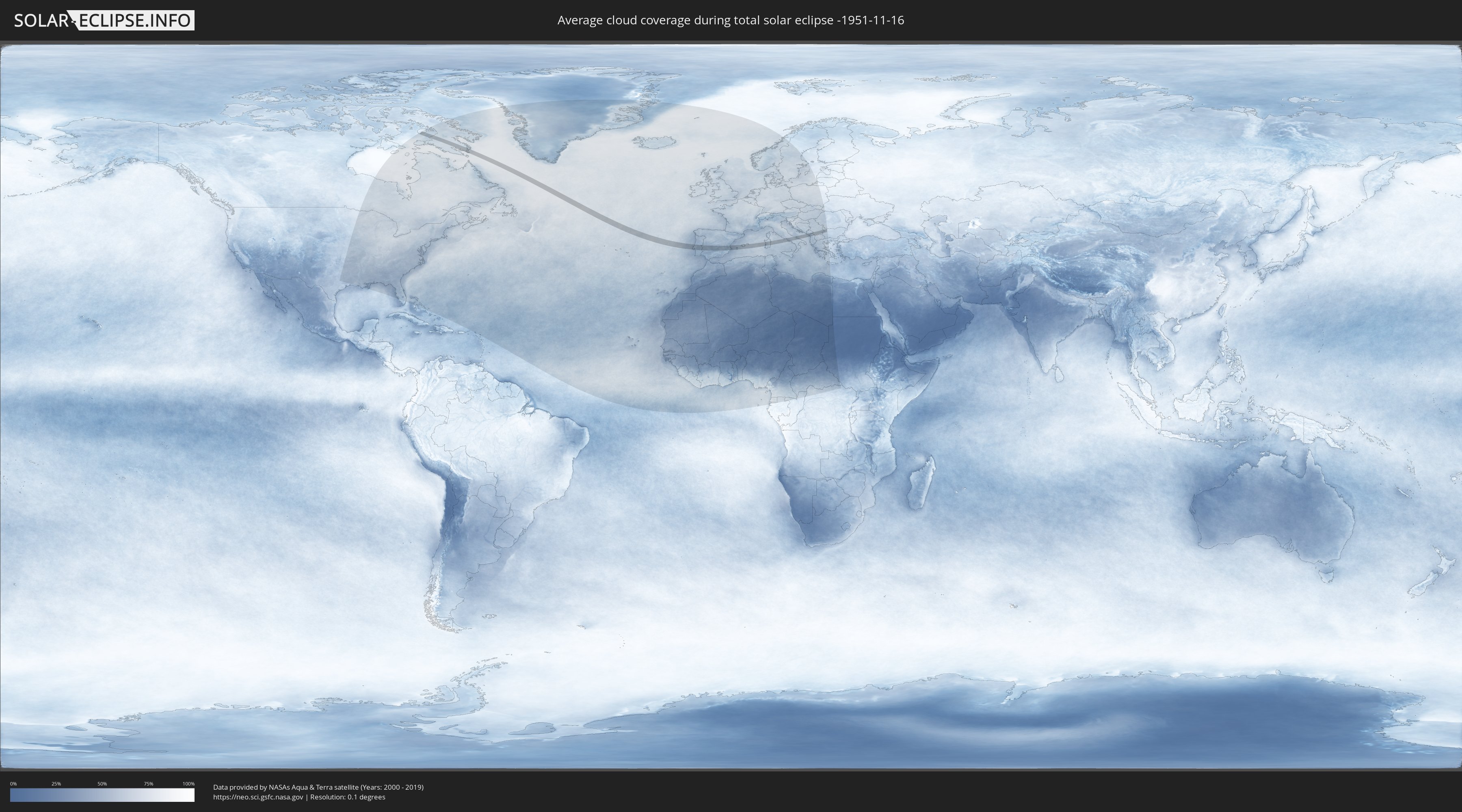
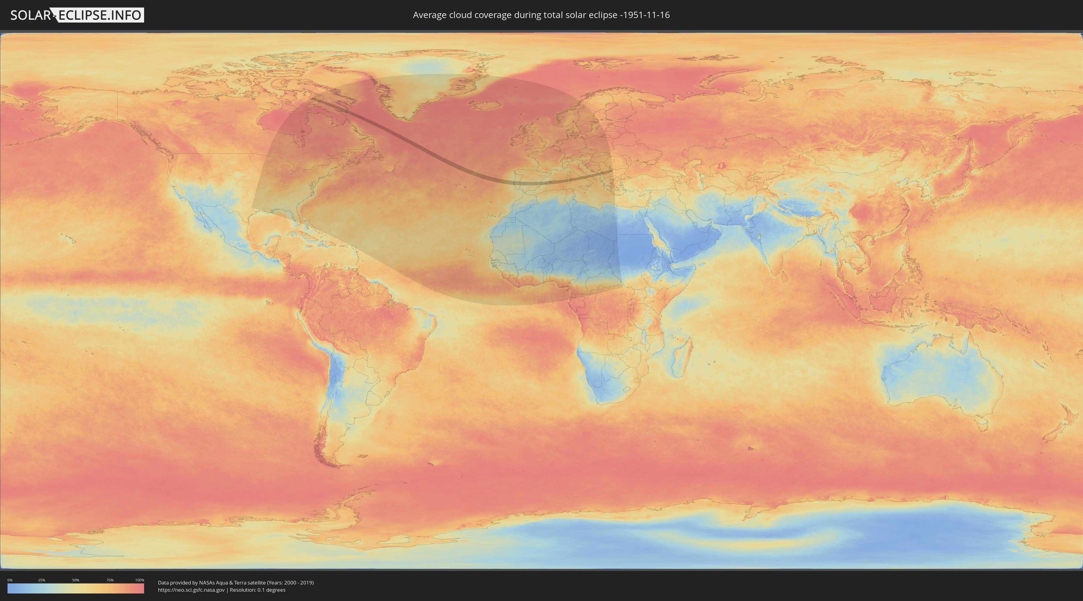
How will be the weather during the total solar eclipse on 11/16/-1951?
Where is the best place to see the total solar eclipse of 11/16/-1951?
The following maps show the average cloud coverage for the day of the total solar eclipse.
With the help of these maps, it is possible to find the place along the eclipse path, which has the best
chance of a cloudless sky.
Nevertheless, you should consider local circumstances and inform about the weather of your chosen
observation site.
The data is provided by NASAs satellites
AQUA and TERRA.
The cloud maps are averaged over a period of 19 years (2000 - 2019).
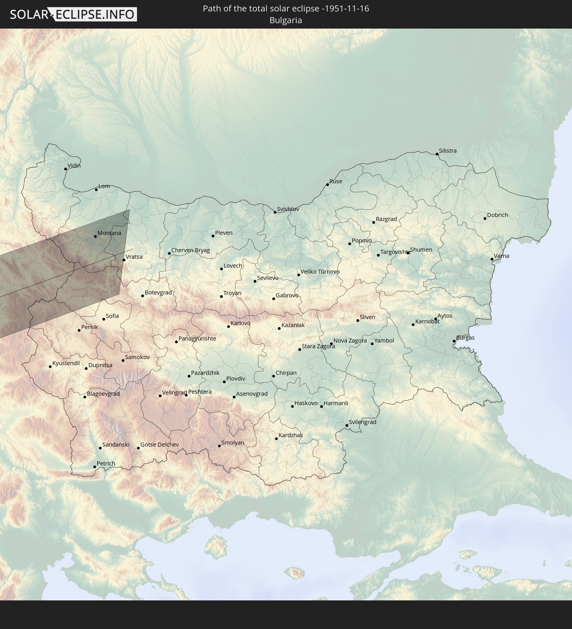
Detailed country maps
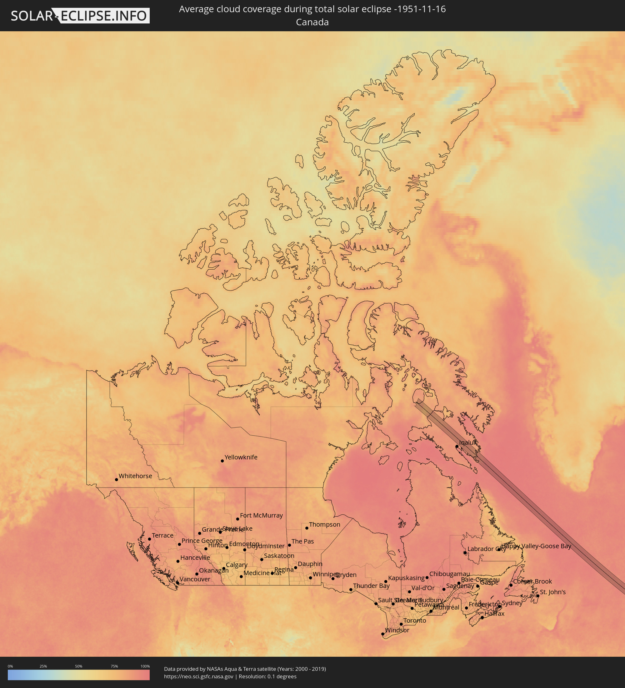 Canada
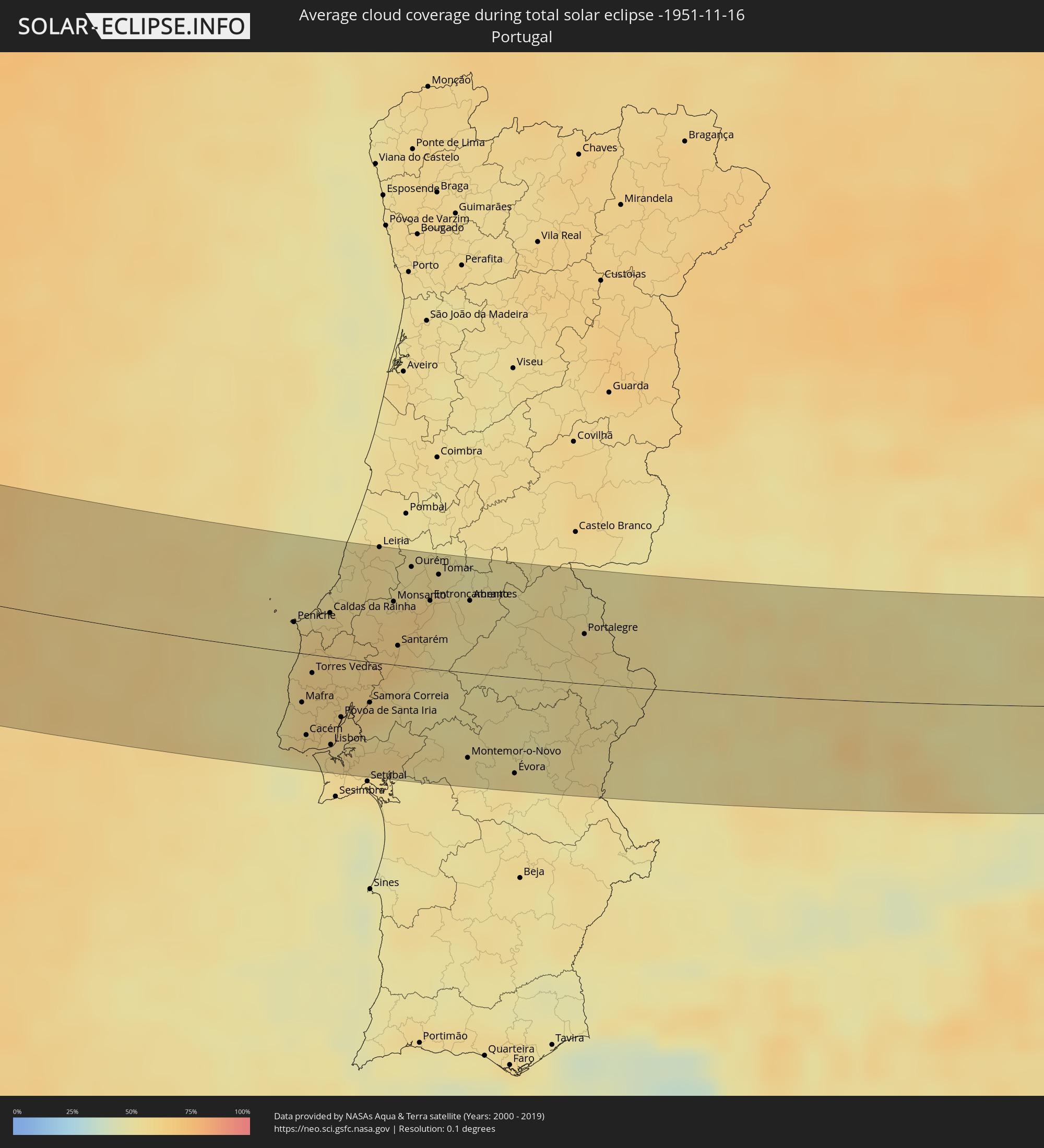 Portugal
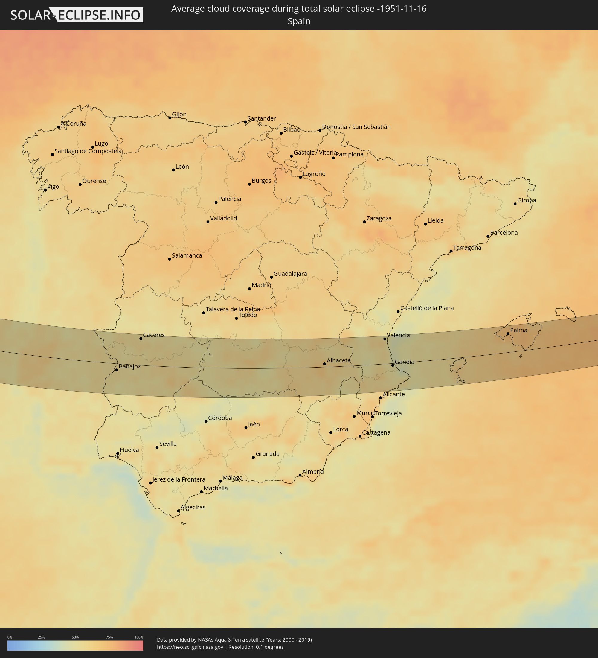 Spain
Spain
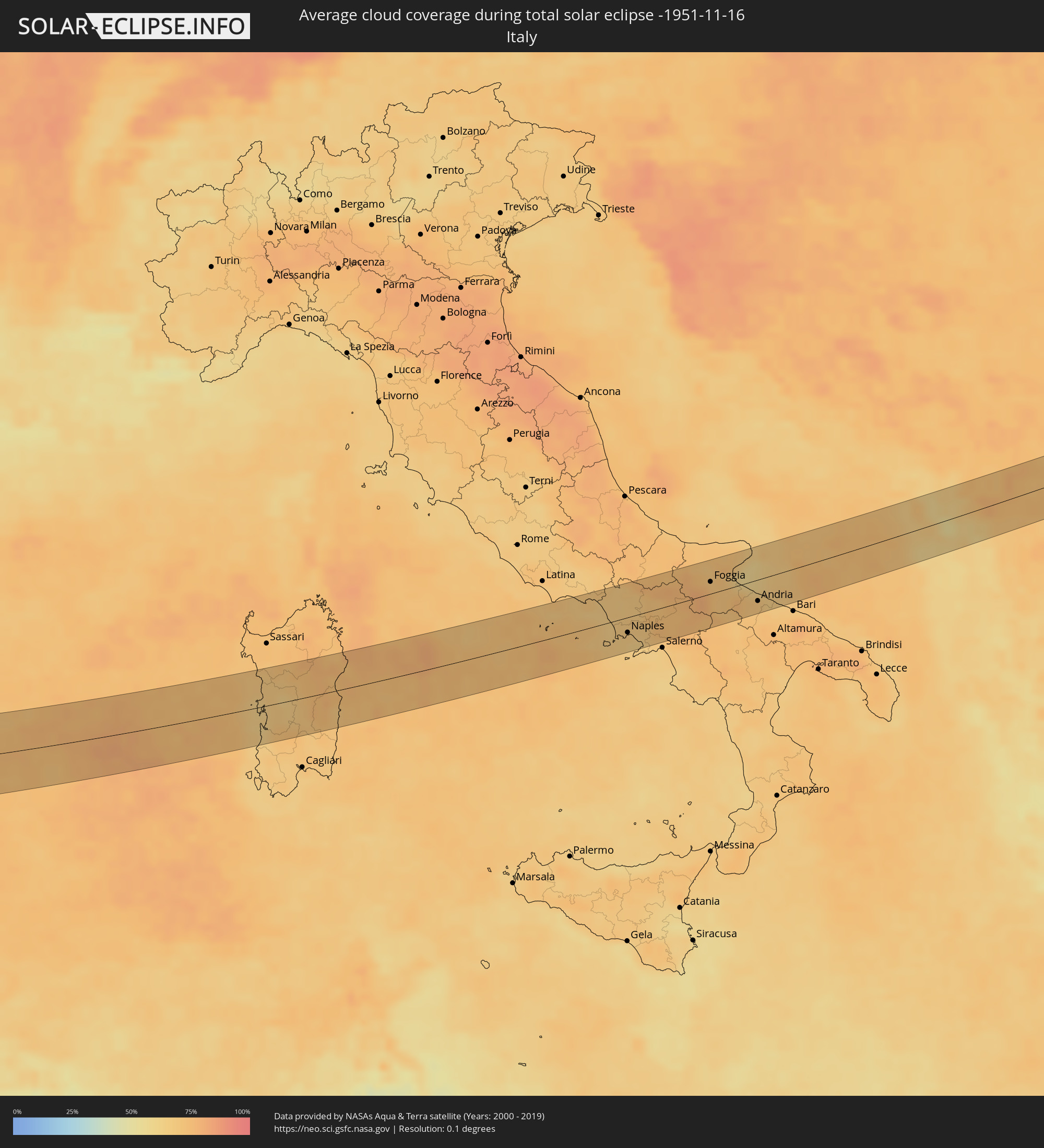 Italy
Italy
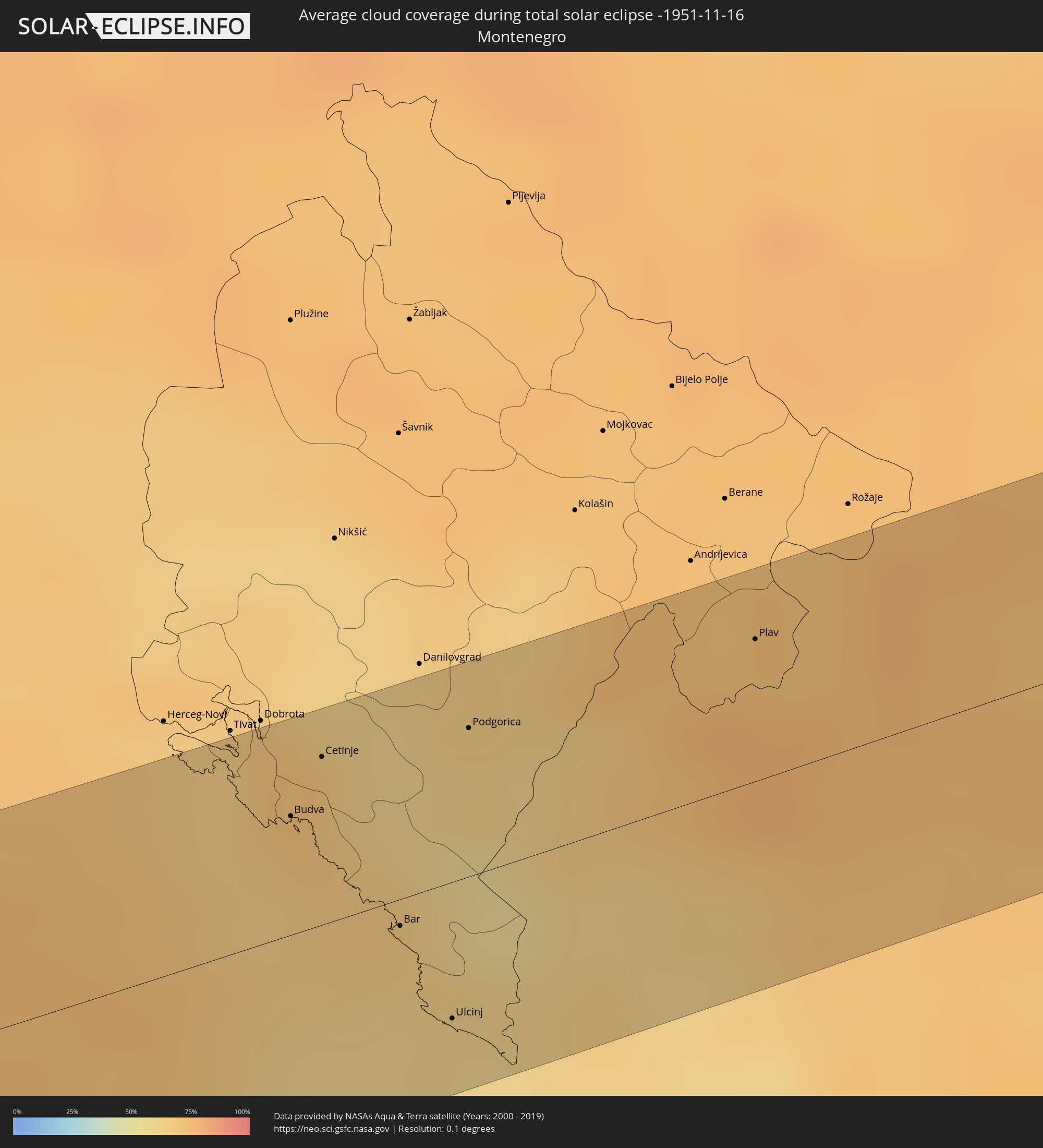 Montenegro
 Serbia
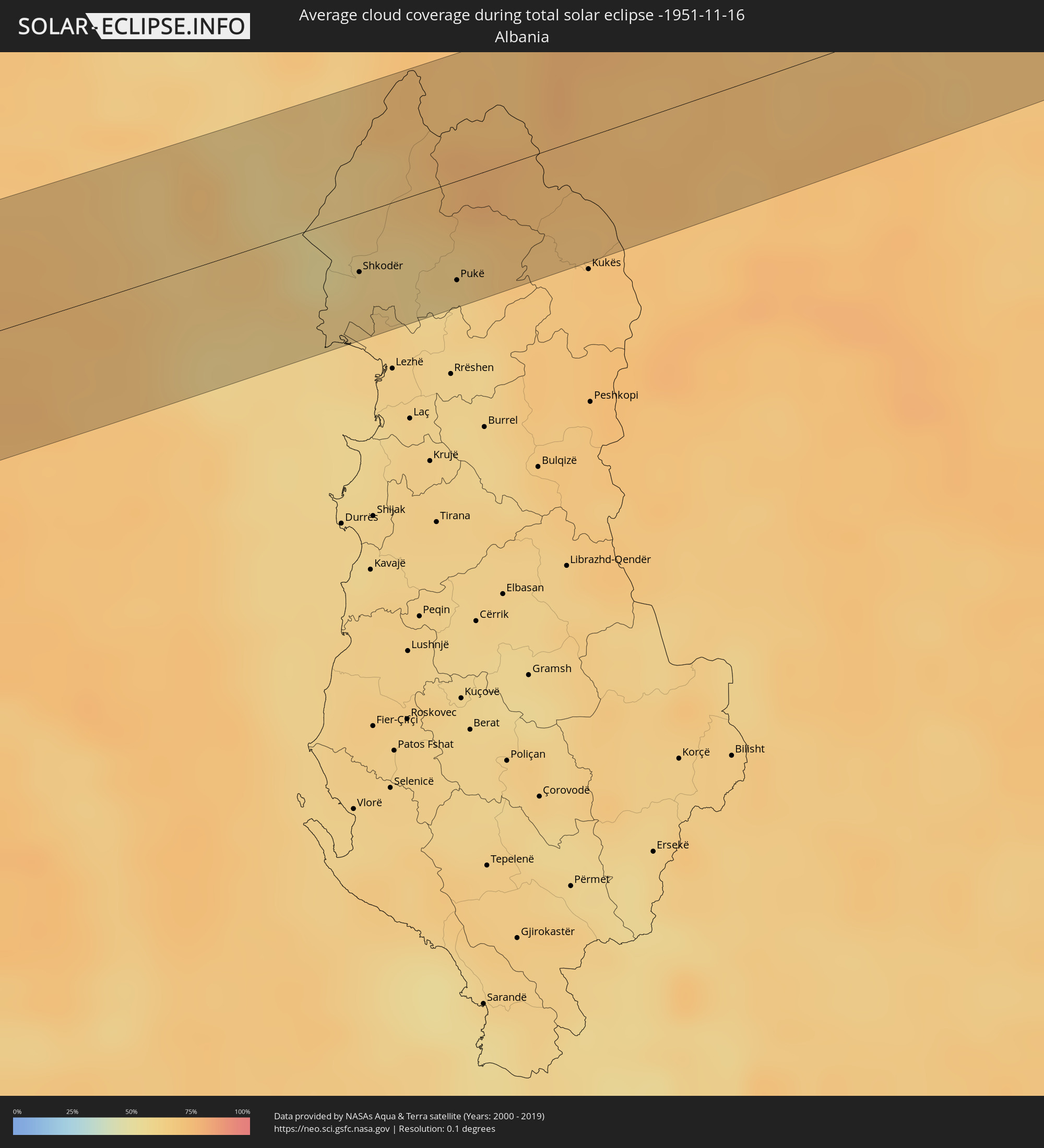 Albania
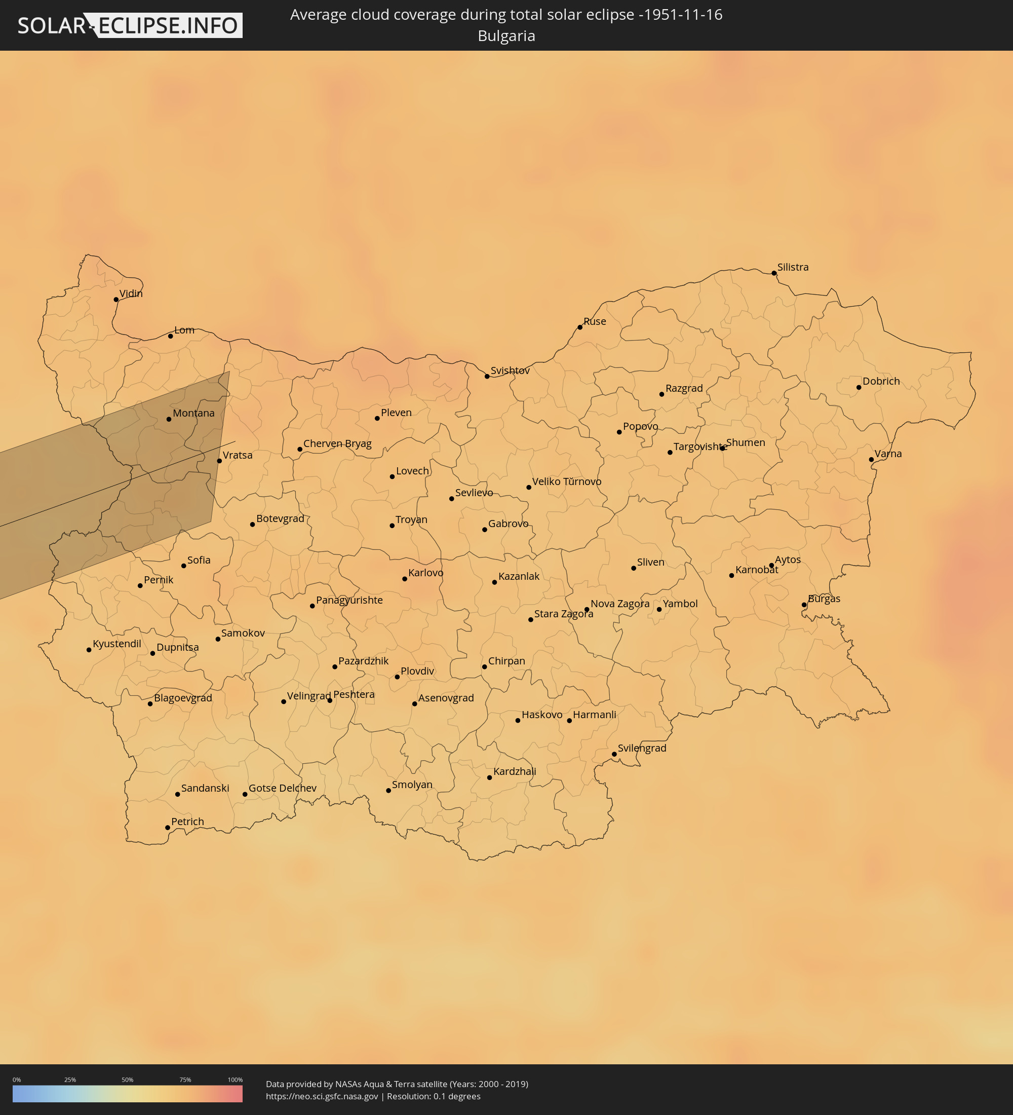 Bulgaria
Cities inside the path of the eclipse
The following table shows all locations with a population of more than 5,000 inside the eclipse path. Cities which have more than 100,000 inhabitants are marked bold. A click at the locations opens a detailed map.
| City | Type | Eclipse duration | Local time of max. eclipse | Distance to central line | Ø Cloud coverage |
|
Peniche, Leiria
|
total | - | 14:16:52 UTC-00:36 | 17 km | 54% |
|
Mafra, Lisbon
|
total | - | 14:17:31 UTC-00:36 | 28 km | 61% |
|
Cacém, Lisbon
|
total | - | 14:17:47 UTC-00:36 | 47 km | 60% |
|
Torres Vedras, Lisbon
|
total | - | 14:17:25 UTC-00:36 | 11 km | 61% |
|
Caldas da Rainha, Leiria
|
total | - | 14:17:12 UTC-00:36 | 25 km | 58% |
|
Lisbon, Lisbon
|
total | - | 14:18:08 UTC-00:36 | 50 km | 58% |
|
Nazaré, Leiria
|
total | - | 14:17:03 UTC-00:36 | 48 km | 56% |
|
Póvoa de Santa Iria, Lisbon
|
total | - | 14:18:03 UTC-00:36 | 34 km | 62% |
|
Alenquer, Lisbon
|
total | - | 14:17:53 UTC-00:36 | 12 km | 62% |
|
Rio Maior, Santarém
|
total | - | 14:17:37 UTC-00:36 | 20 km | 61% |
|
Pinhal Novo, Setúbal
|
total | - | 14:18:36 UTC-00:36 | 58 km | 57% |
|
Samora Correia, Santarém
|
total | - | 14:18:15 UTC-00:36 | 23 km | 57% |
|
Leiria, Leiria
|
total | - | 14:17:17 UTC-00:36 | 66 km | 57% |
|
Monsanto, Santarém
|
total | - | 14:17:49 UTC-00:36 | 36 km | 60% |
|
Santarém, Santarém
|
total | - | 14:18:10 UTC-00:36 | 11 km | 64% |
|
Ourém, Santarém
|
total | - | 14:17:46 UTC-00:36 | 57 km | 56% |
|
Coruche, Santarém
|
total | - | 14:18:47 UTC-00:36 | 18 km | 53% |
|
Entroncamento, Santarém
|
total | - | 14:18:12 UTC-00:36 | 39 km | 62% |
|
Vendas Novas, Évora
|
total | - | 14:19:17 UTC-00:36 | 48 km | 56% |
|
Tomar, Santarém
|
total | - | 14:18:06 UTC-00:36 | 55 km | 57% |
|
Santo André, Portalegre
|
total | - | 14:19:07 UTC-00:36 | 4 km | 50% |
|
Montemor-o-Novo, Évora
|
total | - | 14:19:43 UTC-00:36 | 49 km | 54% |
|
Abrantes, Santarém
|
total | - | 14:18:37 UTC-00:36 | 42 km | 56% |
|
Ponte de Sôr, Portalegre
|
total | - | 14:19:13 UTC-00:36 | 19 km | 51% |
|
Évora, Évora
|
total | - | 14:20:19 UTC-00:36 | 56 km | 56% |
|
Vale da Amoreira, Portalegre
|
total | - | 14:19:57 UTC-00:36 | 2 km | 53% |
|
Estremoz, Évora
|
total | - | 14:20:27 UTC-00:36 | 22 km | 53% |
|
Portalegre, Portalegre
|
total | - | 14:20:04 UTC-00:36 | 29 km | 58% |
|
Elvas, Portalegre
|
total | - | 14:21:03 UTC-00:36 | 15 km | 54% |
|
Badajoz, Extremadura
|
total | - | 14:58:07 UTC+00:00 | 14 km | 55% |
|
Almendralejo, Extremadura
|
total | - | 14:59:15 UTC+00:00 | 33 km | 52% |
|
Cáceres, Extremadura
|
total | - | 14:58:12 UTC+00:00 | 56 km | 56% |
|
Mérida, Extremadura
|
total | - | 14:59:02 UTC+00:00 | 7 km | 54% |
|
Don Benito, Extremadura
|
total | - | 14:59:42 UTC+00:00 | 0 km | 58% |
|
Puertollano, Castille-La Mancha
|
total | - | 15:02:41 UTC+00:00 | 26 km | 54% |
|
Ciudad Real, Castille-La Mancha
|
total | - | 15:02:31 UTC+00:00 | 8 km | 57% |
|
Valdepeñas, Castille-La Mancha
|
total | - | 15:03:37 UTC+00:00 | 17 km | 53% |
|
Alcázar de San Juan, Castille-La Mancha
|
total | - | 15:02:58 UTC+00:00 | 53 km | 59% |
|
Tomelloso, Castille-La Mancha
|
total | - | 15:03:33 UTC+00:00 | 27 km | 52% |
|
Albacete, Castille-La Mancha
|
total | - | 15:05:24 UTC+00:00 | 6 km | 66% |
|
Hellín, Castille-La Mancha
|
total | - | 15:06:18 UTC+00:00 | 49 km | 58% |
|
Yecla, Murcia
|
total | - | 15:06:56 UTC+00:00 | 39 km | 53% |
|
Villena, Valencia
|
total | - | 15:07:14 UTC+00:00 | 38 km | 58% |
|
Elda, Valencia
|
total | - | 15:07:34 UTC+00:00 | 56 km | 60% |
|
Ontinyent, Valencia
|
total | - | 15:07:19 UTC+00:00 | 19 km | 56% |
|
Xàtiva, Valencia
|
total | - | 15:07:11 UTC+00:00 | 1 km | 60% |
|
Alcoy, Valencia
|
total | - | 15:07:39 UTC+00:00 | 32 km | 56% |
|
Alzira, Valencia
|
total | - | 15:07:03 UTC+00:00 | 17 km | 55% |
|
Valencia, Valencia
|
total | - | 15:06:40 UTC+00:00 | 52 km | 58% |
|
Gandia, Valencia
|
total | - | 15:07:39 UTC+00:00 | 5 km | 52% |
|
Benidorm, Valencia
|
total | - | 15:08:20 UTC+00:00 | 53 km | 45% |
|
Calp, Valencia
|
total | - | 15:08:25 UTC+00:00 | 42 km | 48% |
|
Denia, Valencia
|
total | - | 15:08:12 UTC+00:00 | 21 km | 57% |
|
Ibiza, Balearic Islands
|
total | - | 15:09:46 UTC+00:00 | 23 km | 62% |
|
Palma, Balearic Islands
|
total | - | 15:10:14 UTC+00:00 | 38 km | 70% |
|
Llucmajor, Balearic Islands
|
total | - | 15:10:38 UTC+00:00 | 27 km | 70% |
|
Inca, Balearic Islands
|
total | - | 15:10:19 UTC+00:00 | 52 km | 71% |
|
Manacor, Balearic Islands
|
total | - | 15:10:53 UTC+00:00 | 32 km | 71% |
|
Oristano, Sardinia
|
total | - | 16:15:59 UTC+01:00 | 9 km | 65% |
|
Guspini, Sardinia
|
total | - | 16:16:34 UTC+01:00 | 49 km | 67% |
|
Macomer, Sardinia
|
total | - | 16:15:36 UTC+01:00 | 27 km | 68% |
|
Nuoro, Sardinia
|
total | - | 16:16:02 UTC+01:00 | 23 km | 74% |
|
Formia, Latium
|
total | - | 16:18:07 UTC+01:00 | 38 km | 70% |
|
Forio, Campania
|
total | - | 16:19:06 UTC+01:00 | 24 km | 69% |
|
Mondragone, Campania
|
total | - | 16:18:33 UTC+01:00 | 16 km | 64% |
|
Bacoli, Campania
|
total | - | 16:19:10 UTC+01:00 | 22 km | 67% |
|
Casal di Principe, Campania
|
total | - | 16:18:53 UTC+01:00 | 0 km | 68% |
|
Naples, Campania
|
total | - | 16:19:12 UTC+01:00 | 19 km | 66% |
|
Caserta, Campania
|
total | - | 16:18:56 UTC+01:00 | 2 km | 69% |
|
Piedimonte Matese, Campania
|
total | - | 16:18:32 UTC+01:00 | 31 km | 69% |
|
Somma Vesuviana, Campania
|
total | - | 16:19:19 UTC+01:00 | 22 km | 65% |
|
Castellammare di Stabia, Campania
|
total | - | 16:19:37 UTC+01:00 | 41 km | 64% |
|
Sarno, Campania
|
total | - | 16:19:33 UTC+01:00 | 33 km | 66% |
|
Benevento, Campania
|
total | - | 16:19:10 UTC+01:00 | 2 km | 73% |
|
Avellino, Campania
|
total | - | 16:19:30 UTC+01:00 | 25 km | 71% |
|
Lucera, Apulia
|
total | - | 16:18:58 UTC+01:00 | 25 km | 77% |
|
San Severo, Apulia
|
total | - | 16:18:43 UTC+01:00 | 43 km | 70% |
|
Foggia, Apulia
|
total | - | 16:19:11 UTC+01:00 | 15 km | 71% |
|
Orta Nova, Apulia
|
total | - | 16:19:30 UTC+01:00 | 3 km | 70% |
|
San Giovanni Rotondo, Apulia
|
total | - | 16:18:56 UTC+01:00 | 37 km | 73% |
|
Lavello, Basilicate
|
total | - | 16:19:59 UTC+01:00 | 34 km | 72% |
|
Cerignola, Apulia
|
total | - | 16:19:43 UTC+01:00 | 14 km | 73% |
|
Manfredonia, Apulia
|
total | - | 16:19:10 UTC+01:00 | 25 km | 66% |
|
Canosa di Puglia, Apulia
|
total | - | 16:19:54 UTC+01:00 | 23 km | 72% |
|
Trinitapoli, Apulia
|
total | - | 16:19:42 UTC+01:00 | 9 km | 70% |
|
Andria, Apulia
|
total | - | 16:20:02 UTC+01:00 | 27 km | 70% |
|
Molfetta, Apulia
|
total | - | 16:20:16 UTC+01:00 | 37 km | 67% |
|
Kotor, Kotor
|
total | - | 16:19:42 UTC+01:00 | 38 km | 70% |
|
Budva, Budva
|
total | - | 16:19:57 UTC+01:00 | 22 km | 67% |
|
Cetinje, Cetinje
|
total | - | 16:19:50 UTC+01:00 | 31 km | 70% |
|
Bar, Bar
|
total | - | 16:20:24 UTC+01:00 | 5 km | 63% |
|
Ulcinj, Ulcinj
|
total | - | 16:20:43 UTC+01:00 | 25 km | 61% |
|
Podgorica, Podgorica
|
total | - | 16:19:57 UTC+01:00 | 28 km | 63% |
|
Shkodër, Shkodër
|
total | - | 16:40:00 UTC+01:19 | 18 km | 62% |
|
Pukë, Shkodër
|
total | - | 16:40:14 UTC+01:19 | 31 km | 64% |
|
Plav, Opština Plav
|
total | - | 16:20:04 UTC+01:00 | 26 km | 73% |
|
Vranje, Central Serbia
|
total | - | 16:21:07 UTC+01:00 | 31 km | 72% |
|
Leskovac, Central Serbia
|
total | - | 16:20:27 UTC+01:00 | 15 km | 70% |
|
Pirot, Central Serbia
|
total | - | 16:20:30 UTC+01:00 | 14 km | 68% |
|
Slivnitsa, Sofia Province
|
total | - | 17:21:10 UTC+02:00 | 31 km | 72% |
|
Godech, Sofia Province
|
total | - | 17:20:55 UTC+02:00 | 14 km | 72% |
|
Berkovitsa, Montana
|
total | - | 17:20:37 UTC+02:00 | 7 km | 73% |
|
Montana, Montana
|
total | - | 17:20:23 UTC+02:00 | 23 km | 74% |
|
Varshets, Montana
|
total | - | 17:20:45 UTC+02:00 | 1 km | 73% |
|
Svoge, Sofia Province
|
total | - | 17:21:07 UTC+02:00 | 27 km | 69% |