Total solar eclipse of 02/19/0174
| Day of week: | Saturday |
| Maximum duration of eclipse: | 03m43s |
| Maximum width of eclipse path: | 272 km |
| Saros cycle: | 62 |
| Coverage: | 100% |
| Magnitude: | 1.0472 |
| Gamma: | 0.8182 |
Wo kann man die Sonnenfinsternis vom 02/19/0174 sehen?
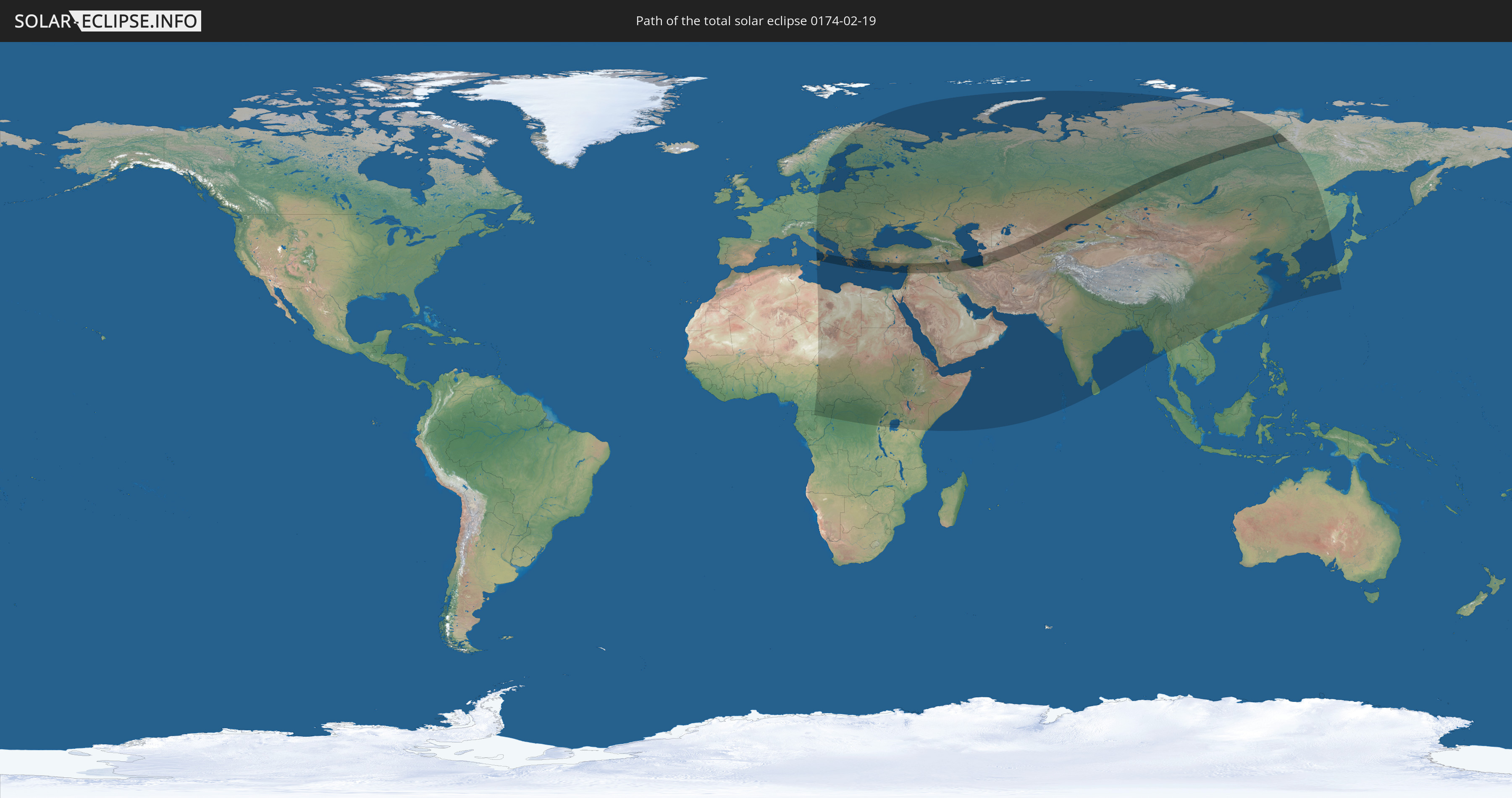
Die Sonnenfinsternis am 02/19/0174 kann man in 89 Ländern als partielle Sonnenfinsternis beobachten.
Der Finsternispfad verläuft durch 10 Länder. Nur in diesen Ländern ist sie als total Sonnenfinsternis zu sehen.
In den folgenden Ländern ist die Sonnenfinsternis total zu sehen
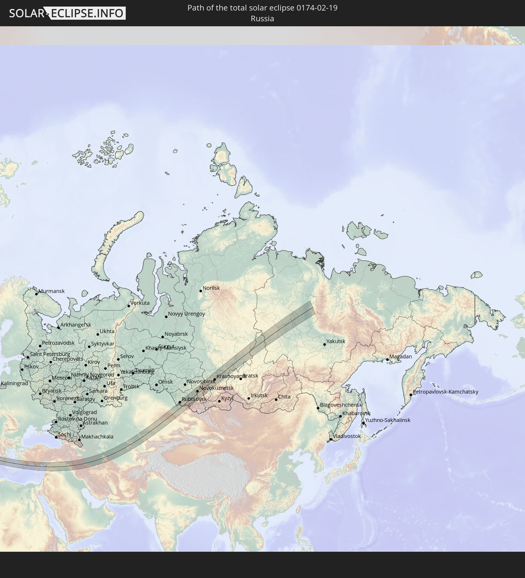 Russia
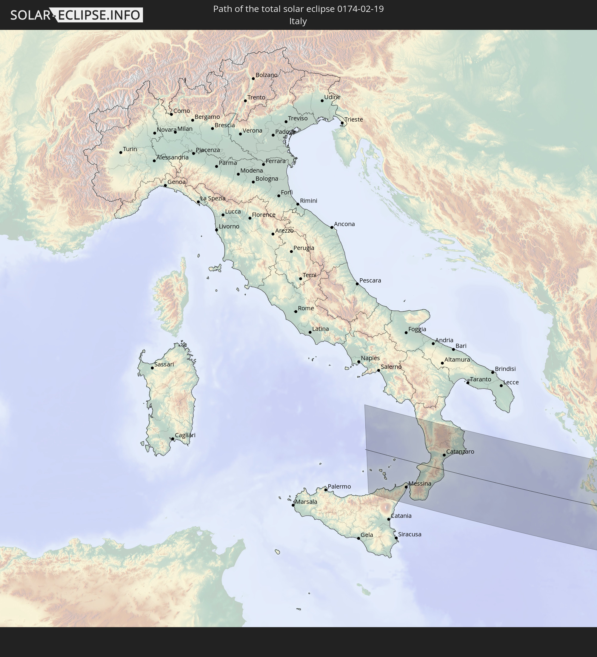 Italy
Italy
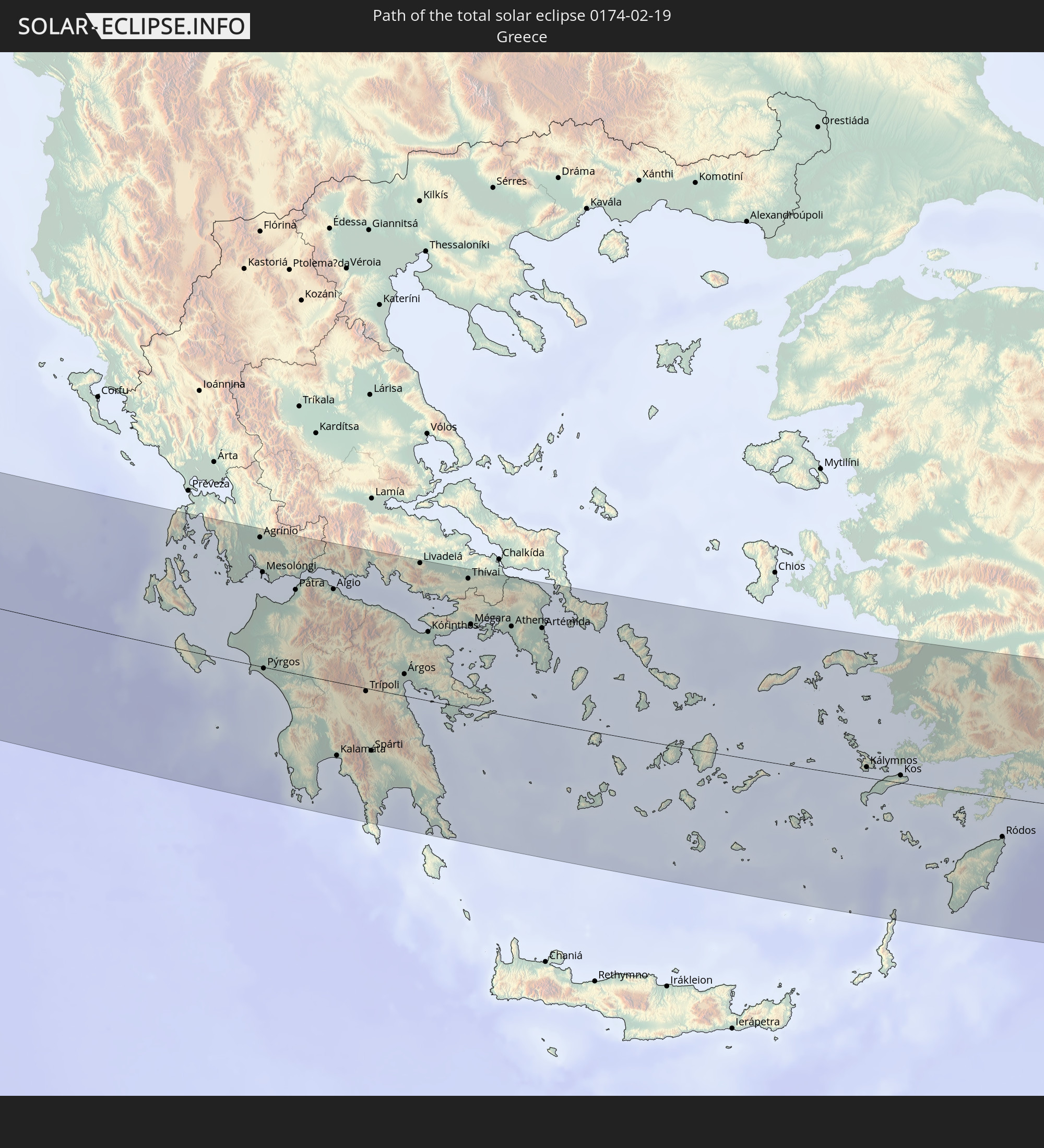 Greece
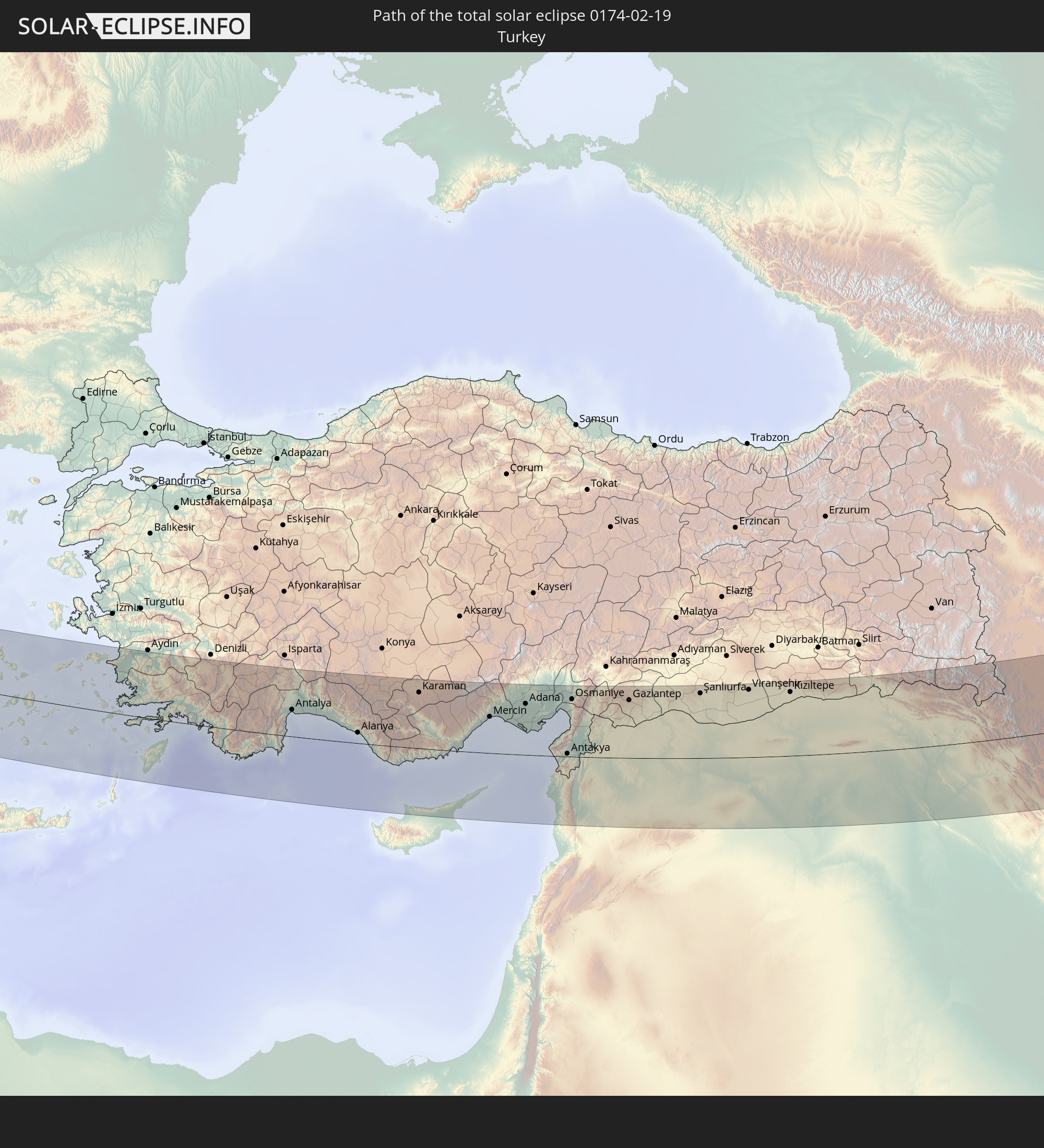 Turkey
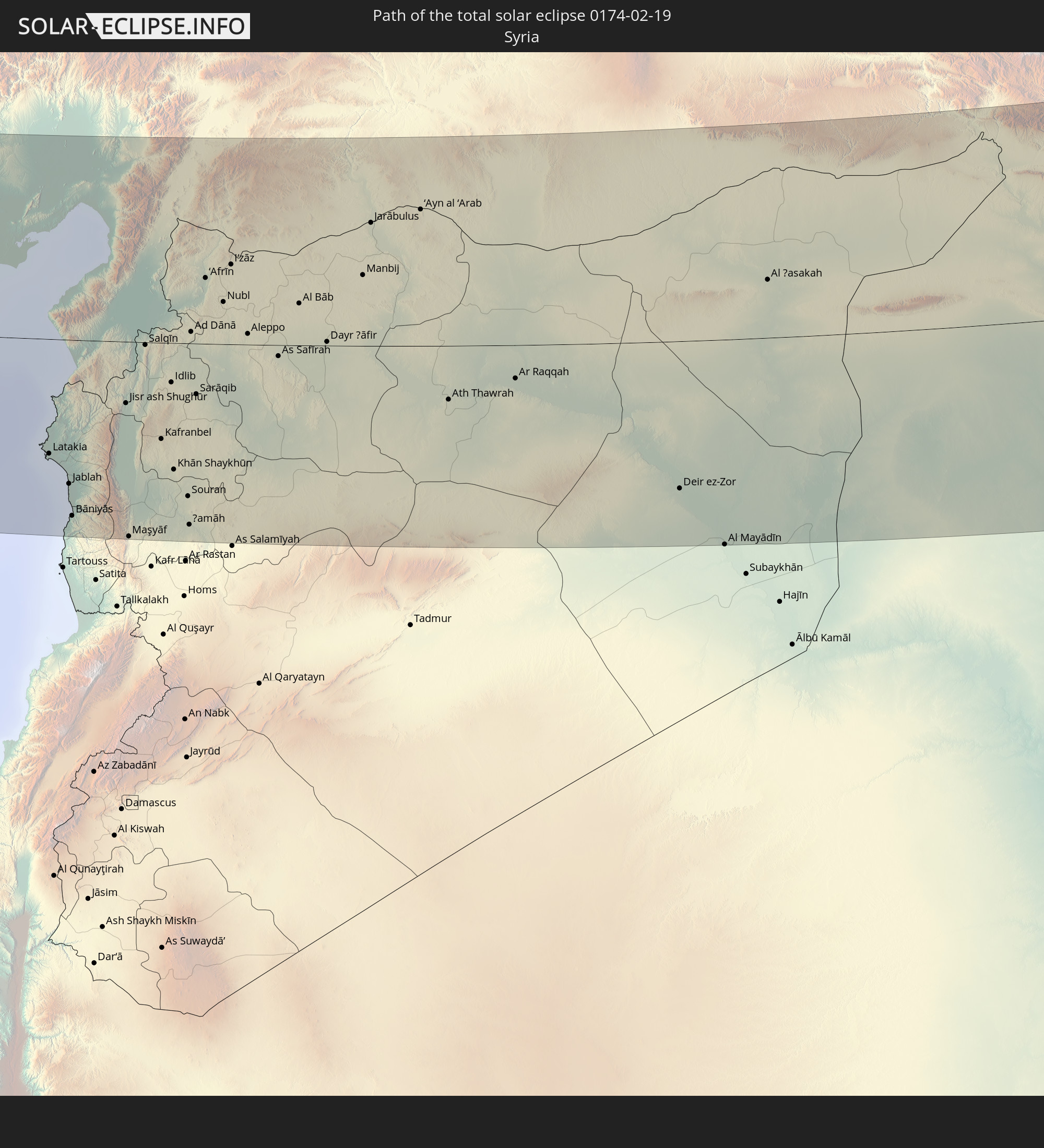 Syria
Syria
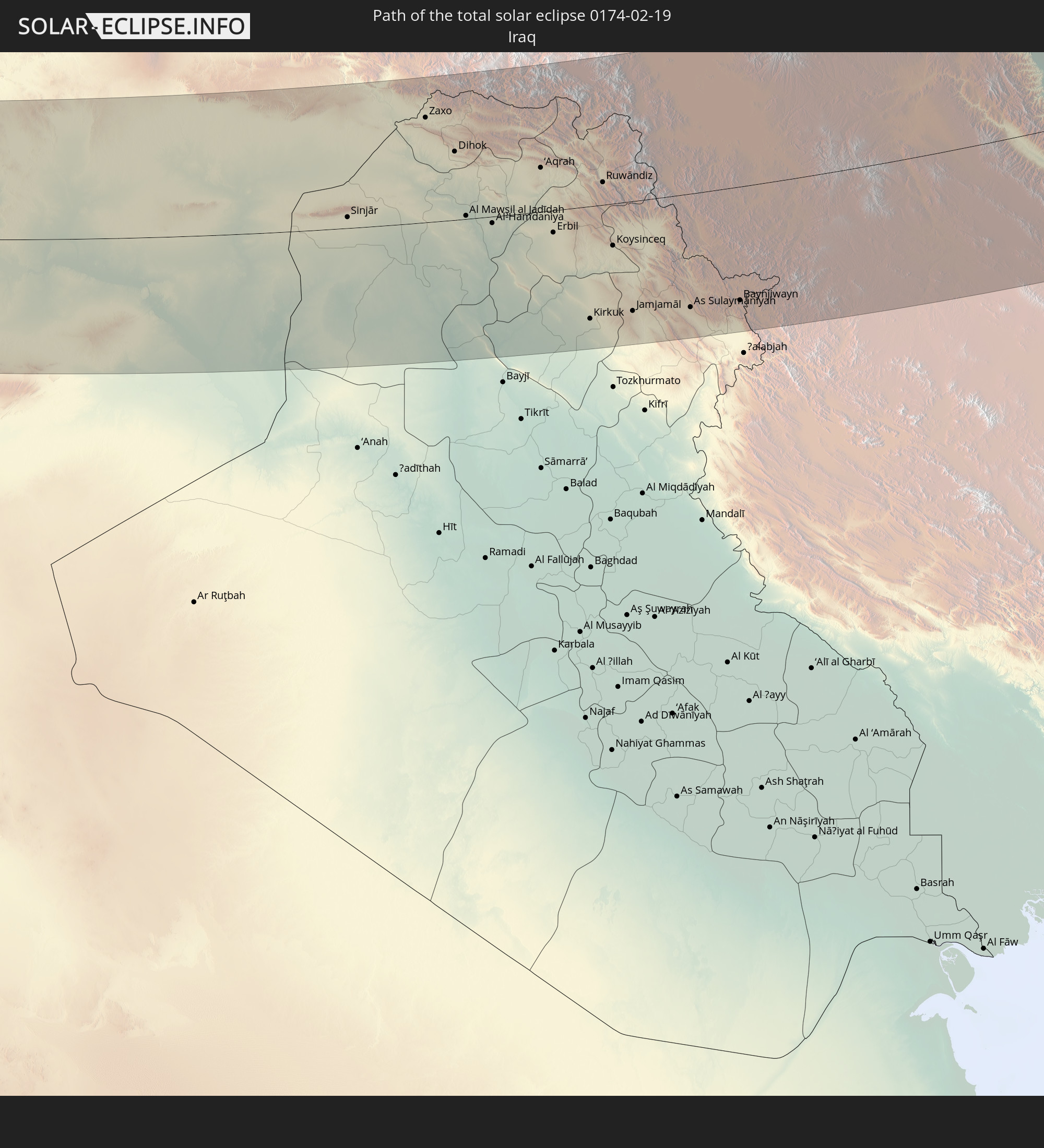 Iraq
Iraq
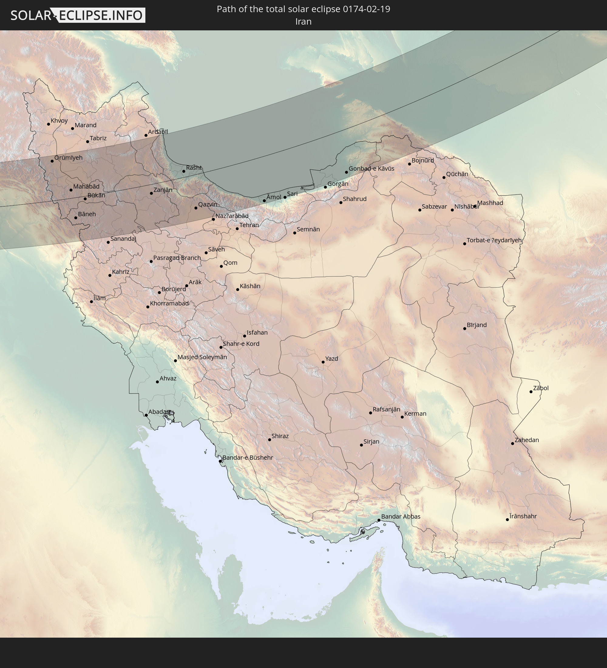 Iran
Iran
 Kazakhstan
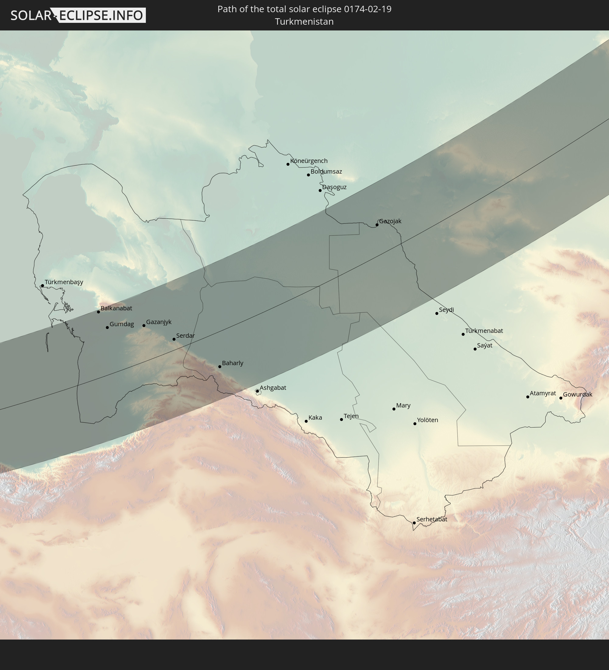 Turkmenistan
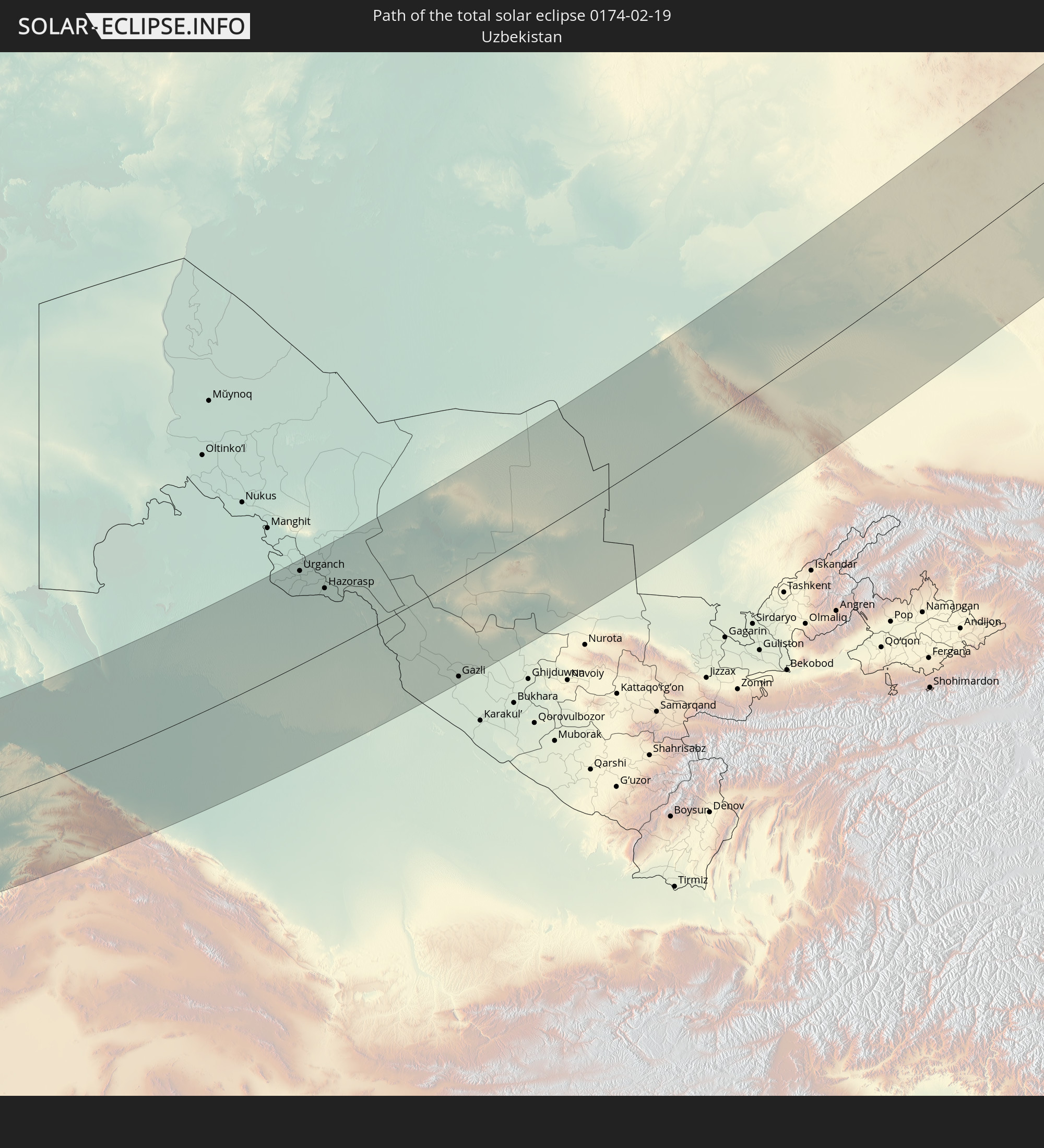 Uzbekistan
In den folgenden Ländern ist die Sonnenfinsternis partiell zu sehen
 Russia
 Niger
Niger
 Norway
 Germany
 Italy
Italy
 Cameroon
 Gabon
Gabon
 Libya
Libya
 Austria
 Sweden
 Republic of the Congo
 Czechia
 Democratic Republic of the Congo
 Slovenia
 Chad
Chad
 Croatia
 Poland
 Malta
Malta
 Central African Republic
 Bosnia and Herzegovina
 Hungary
 Slovakia
 Montenegro
 Serbia
 Albania
 Åland Islands
 Greece
 Romania
 Republic of Macedonia
 Finland
 Lithuania
 Latvia
 Estonia
 Sudan
Sudan
 Ukraine
 Bulgaria
 Belarus
 Egypt
Egypt
 Turkey
 Moldova
 Rwanda
 Tanzania
 Uganda
 Cyprus
 Ethiopia
 Kenya
Kenya
 State of Palestine
 Israel
 Saudi Arabia
 Jordan
 Lebanon
 Syria
Syria
 Eritrea
 Iraq
Iraq
 Georgia
 Somalia
 Djibouti
 Yemen
Yemen
 Armenia
 Iran
Iran
 Azerbaijan
 Kazakhstan
 Kuwait
 Bahrain
 Qatar
Qatar
 United Arab Emirates
 Oman
Oman
 Turkmenistan
 Uzbekistan
 Afghanistan
 Pakistan
 Tajikistan
 India
India
 Kyrgyzstan
 Maldives
 China
China
 Sri Lanka
 Nepal
Nepal
 Mongolia
 Bangladesh
 Bhutan
 Myanmar
 Thailand
 Laos
Laos
 Vietnam
 Taiwan
 Japan
Japan
 North Korea
 South Korea
How will be the weather during the total solar eclipse on 02/19/0174?
Where is the best place to see the total solar eclipse of 02/19/0174?
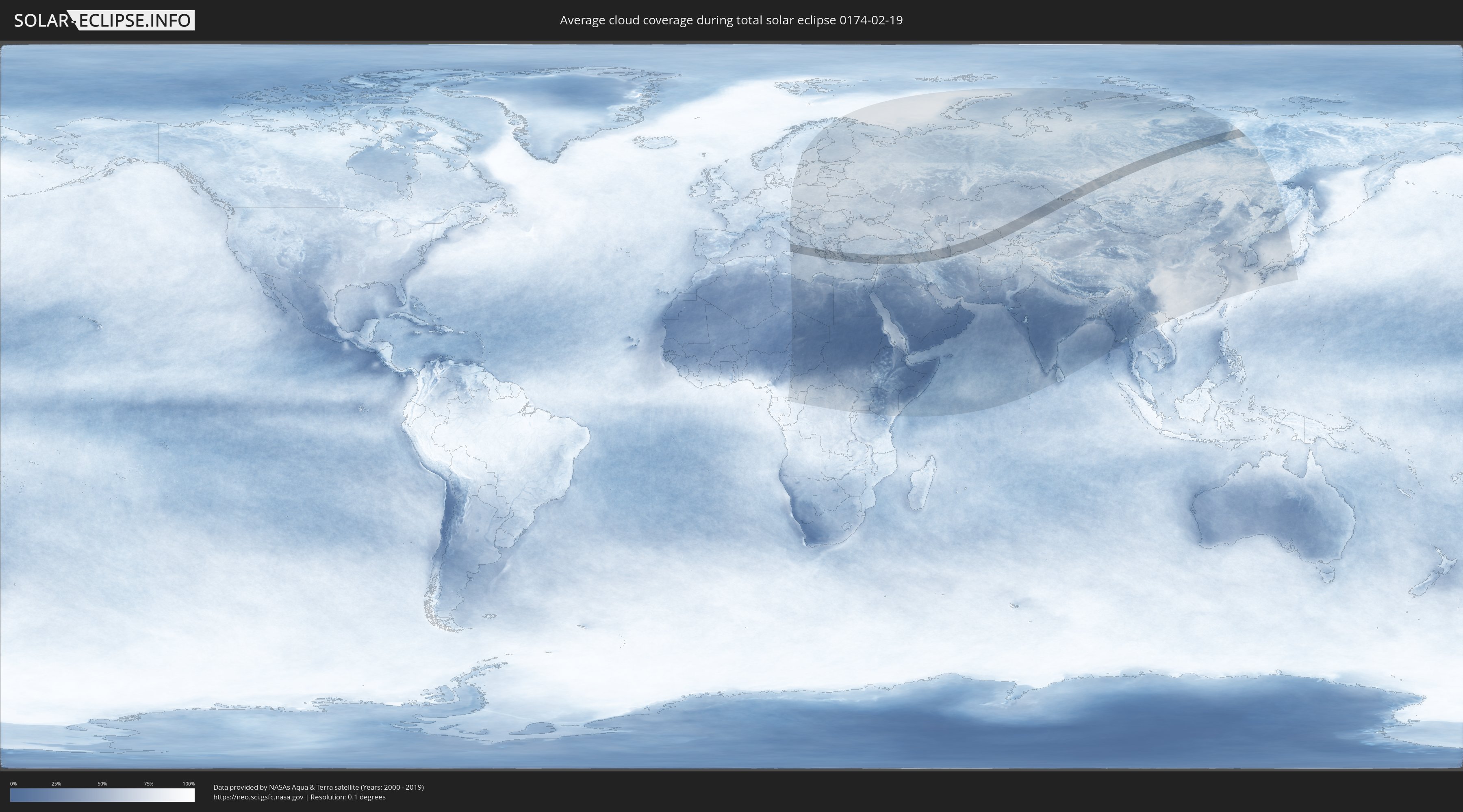
The following maps show the average cloud coverage for the day of the total solar eclipse.
With the help of these maps, it is possible to find the place along the eclipse path, which has the best
chance of a cloudless sky.
Nevertheless, you should consider local circumstances and inform about the weather of your chosen
observation site.
The data is provided by NASAs satellites
AQUA and TERRA.
The cloud maps are averaged over a period of 19 years (2000 - 2019).

Detailed country maps
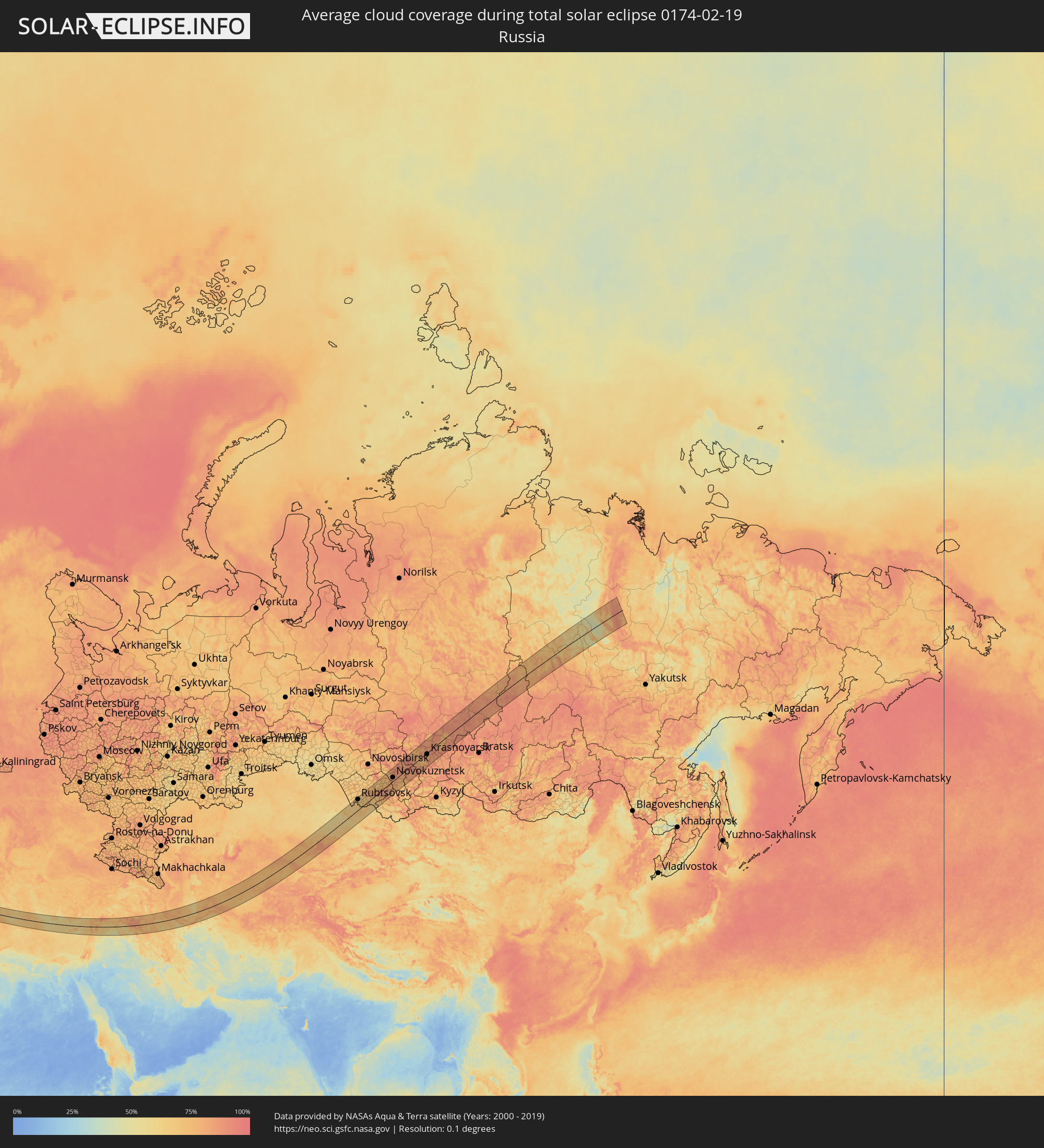 Russia
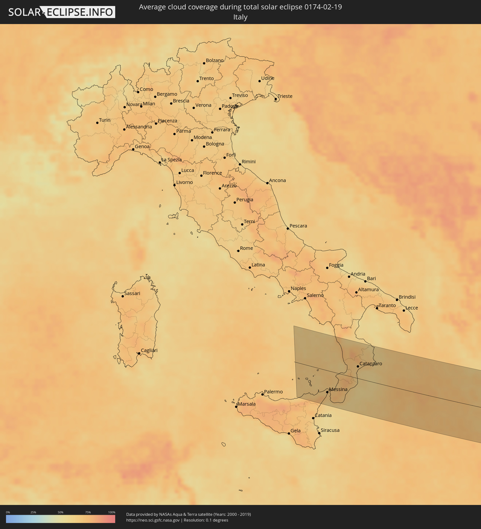 Italy
Italy
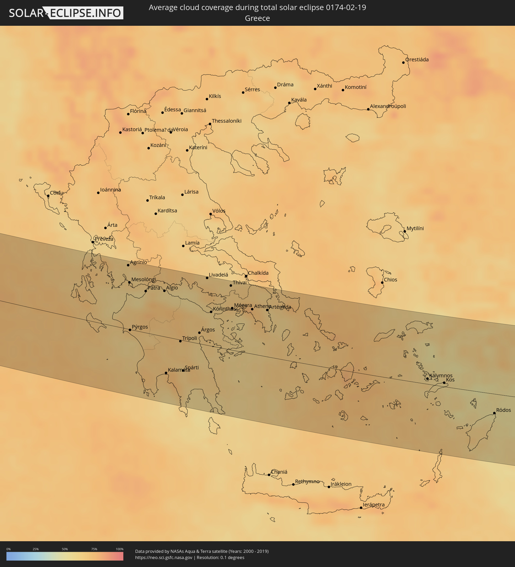 Greece
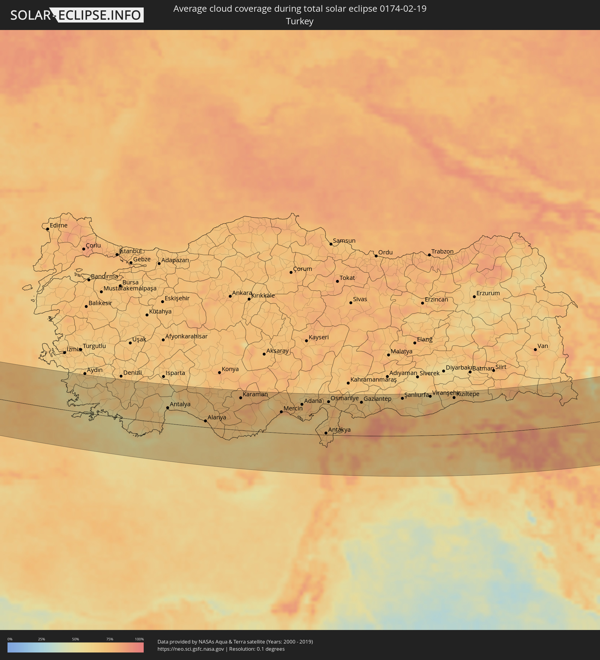 Turkey
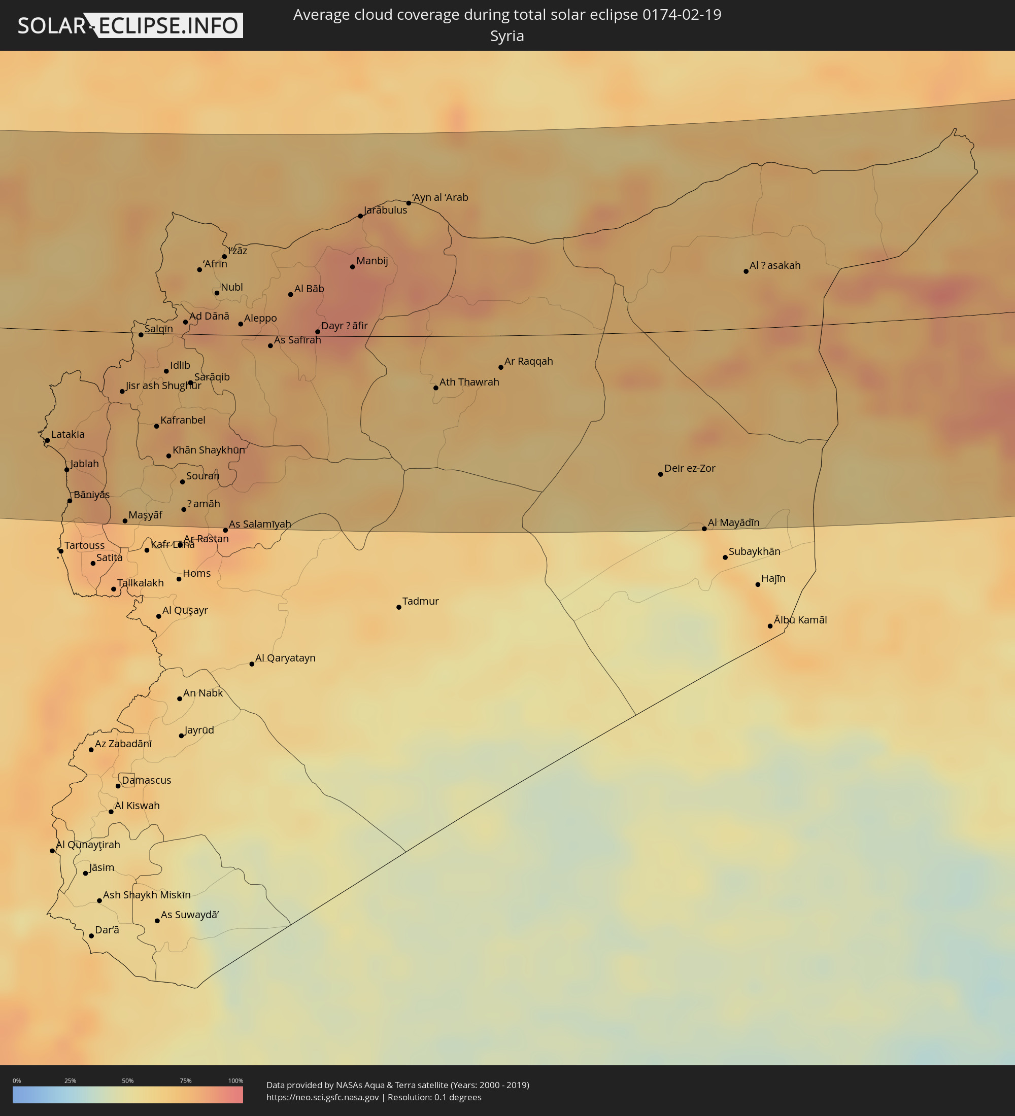 Syria
Syria
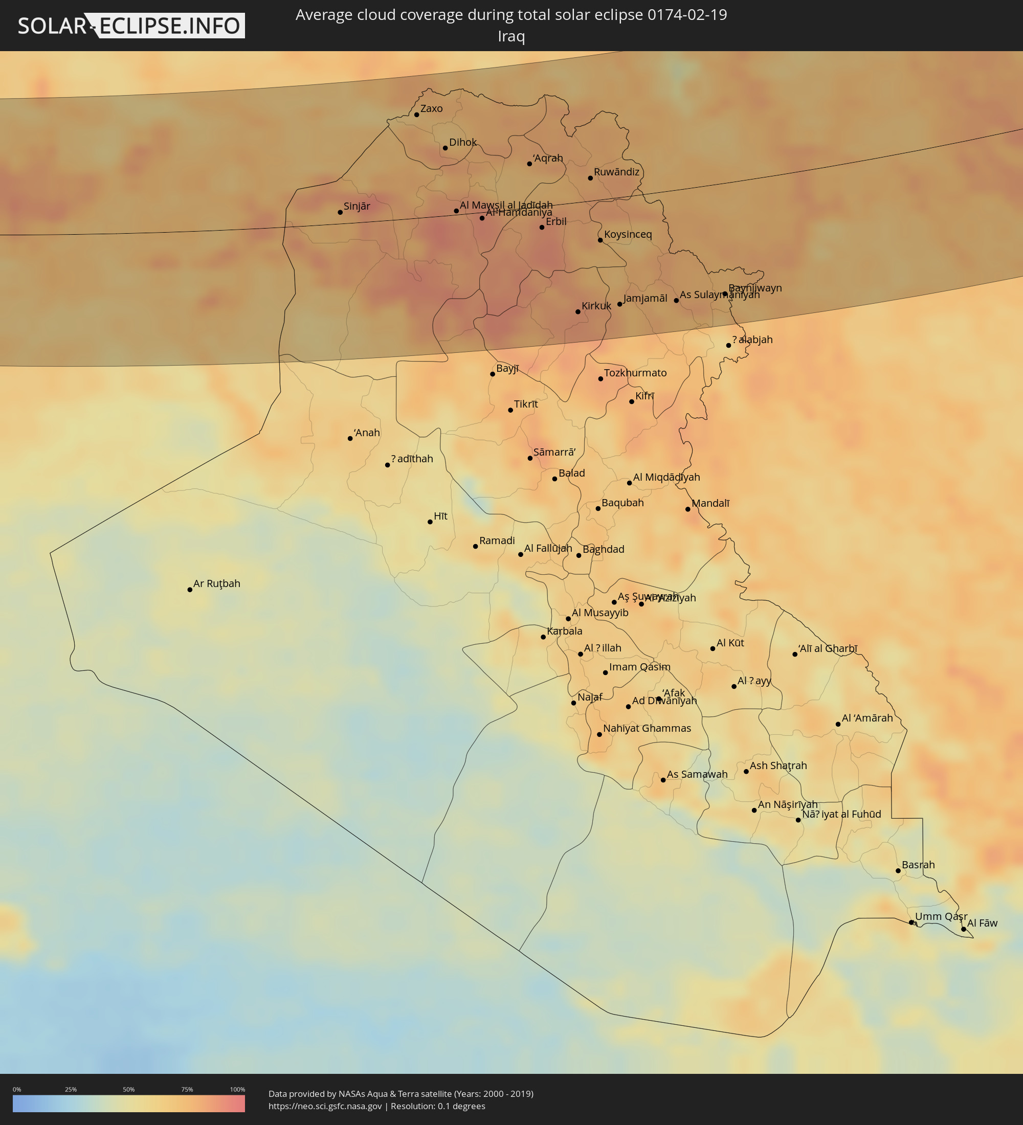 Iraq
Iraq
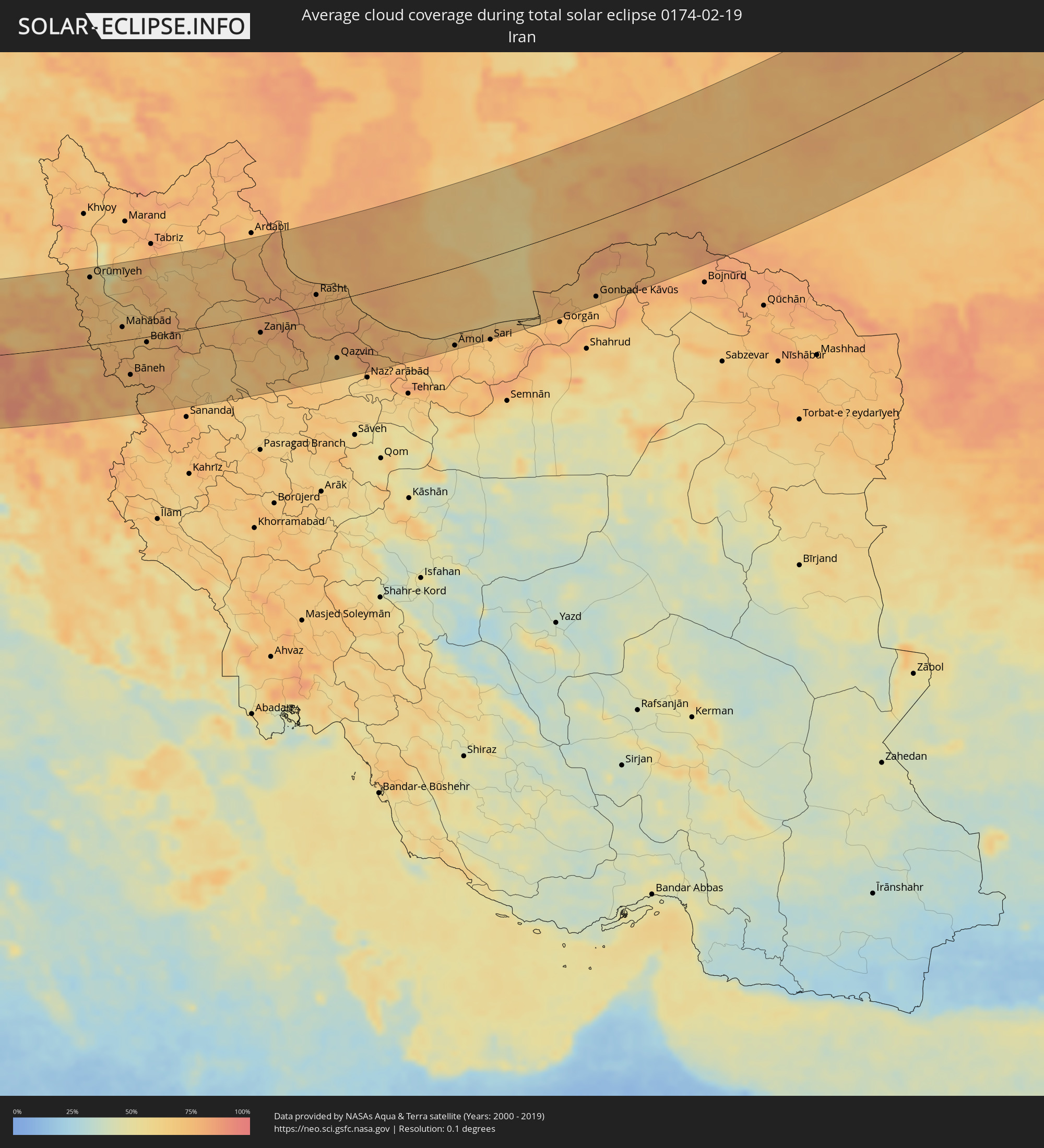 Iran
Iran
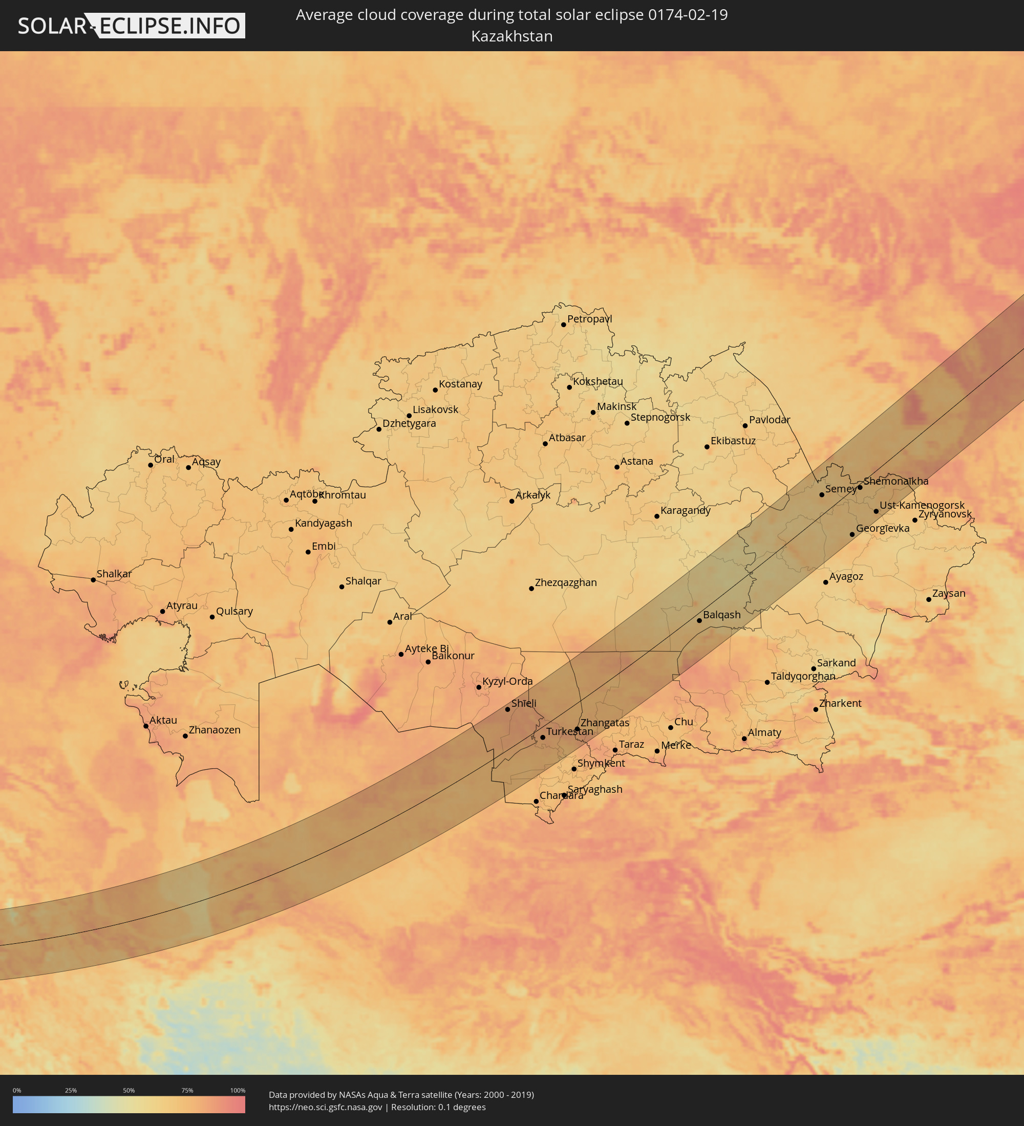 Kazakhstan
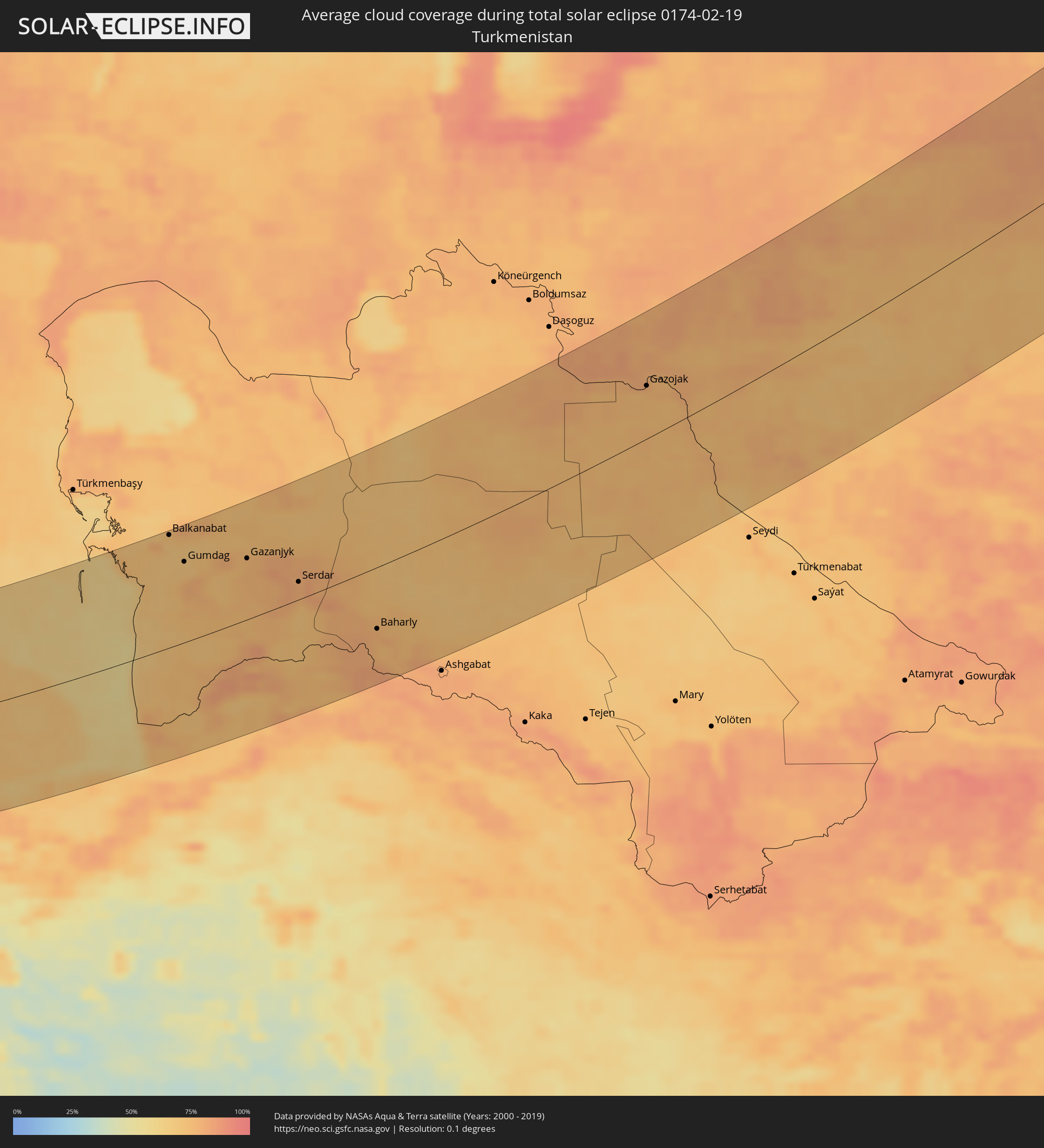 Turkmenistan
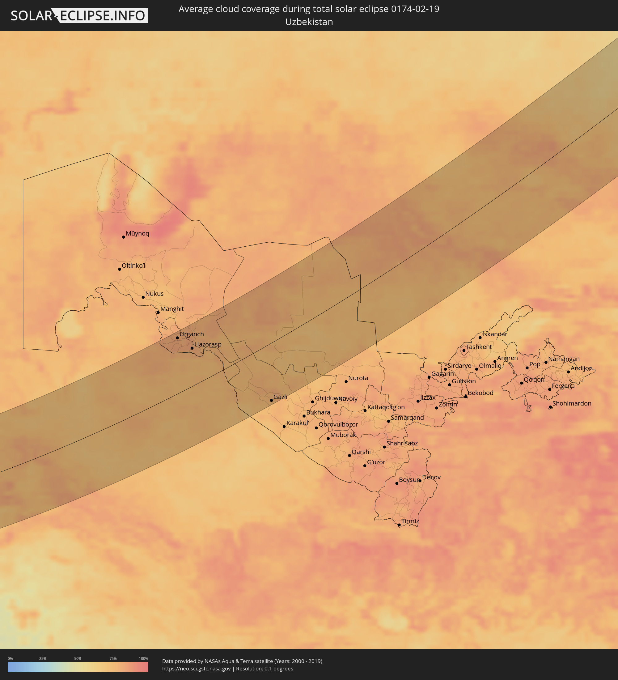 Uzbekistan
Cities inside the path of the eclipse
The following table shows all locations with a population of more than 5,000 inside the eclipse path. Cities which have more than 100,000 inhabitants are marked bold. A click at the locations opens a detailed map.
| City | Type | Eclipse duration | Local time of max. eclipse | Distance to central line | Ø Cloud coverage |
|
Capo d'Orlando, Sicily
|
total | - | 06:56:09 UTC+01:00 | 87 km | 72% |
|
Patti, Sicily
|
total | - | 06:56:14 UTC+01:00 | 81 km | 75% |
|
Barcellona Pozzo di Gotto, Sicily
|
total | - | 06:56:19 UTC+01:00 | 75 km | 75% |
|
Messina, Sicily
|
total | - | 06:56:30 UTC+01:00 | 63 km | 68% |
|
Melito di Porto Salvo, Calabria
|
total | - | 06:56:10 UTC+01:00 | 88 km | 60% |
|
Bagnara Calabra, Calabria
|
total | - | 06:56:43 UTC+01:00 | 47 km | 71% |
|
Gioia Tauro, Calabria
|
total | - | 06:56:57 UTC+01:00 | 31 km | 68% |
|
Paola, Calabria
|
total | - | 06:58:24 UTC+01:00 | 74 km | 69% |
|
Polistena, Calabria
|
total | - | 06:56:59 UTC+01:00 | 29 km | 76% |
|
Amantea, Calabria
|
total | - | 06:58:03 UTC+01:00 | 49 km | 64% |
|
Vibo Valentia, Calabria
|
total | - | 06:57:24 UTC+01:00 | 1 km | 72% |
|
Cosenza, Calabria
|
total | - | 06:58:23 UTC+01:00 | 71 km | 72% |
|
Siderno, Calabria
|
total | - | 06:56:52 UTC+01:00 | 39 km | 65% |
|
Lamezia Terme, Calabria
|
total | - | 06:57:54 UTC+01:00 | 36 km | 70% |
|
Acri, Calabria
|
total | - | 06:58:43 UTC+01:00 | 95 km | 71% |
|
Catanzaro, Calabria
|
total | - | 06:57:53 UTC+01:00 | 34 km | 66% |
|
San Giovanni in Fiore, Calabria
|
total | - | 06:58:29 UTC+01:00 | 76 km | 70% |
|
Cirò Marina, Calabria
|
total | - | 06:58:49 UTC+01:00 | 97 km | 60% |
|
Crotone, Calabria
|
total | - | 06:58:23 UTC+01:00 | 66 km | 66% |
|
Amaliáda, West Greece
|
total | - | 07:33:16 UTC+01:34 | 11 km | 68% |
|
Agrínio, West Greece
|
total | - | 07:34:32 UTC+01:34 | 101 km | 64% |
|
Pýrgos, West Greece
|
total | - | 07:33:08 UTC+01:34 | 1 km | 64% |
|
Pátra, West Greece
|
total | - | 07:34:08 UTC+01:34 | 66 km | 59% |
|
Aígio, West Greece
|
total | - | 07:34:20 UTC+01:34 | 73 km | 68% |
|
Kalamáta, Peloponnese
|
total | - | 07:32:33 UTC+01:34 | 58 km | 65% |
|
Trípoli, Peloponnese
|
total | - | 07:33:23 UTC+01:34 | 3 km | 66% |
|
Spárti, Peloponnese
|
total | - | 07:32:46 UTC+01:34 | 49 km | 67% |
|
Árgos, Peloponnese
|
total | - | 07:33:46 UTC+01:34 | 17 km | 63% |
|
Livadeiá, Central Greece
|
total | - | 07:35:04 UTC+01:34 | 107 km | 69% |
|
Kórinthos, Peloponnese
|
total | - | 07:34:22 UTC+01:34 | 54 km | 60% |
|
Thívai, Central Greece
|
total | - | 07:35:10 UTC+01:34 | 103 km | 65% |
|
Salamína, Attica
|
total | - | 07:34:43 UTC+01:34 | 66 km | 61% |
|
Athens, Attica
|
total | - | 07:34:52 UTC+01:34 | 72 km | 72% |
|
Voúla, Attica
|
total | - | 07:34:42 UTC+01:34 | 58 km | 65% |
|
Néa Erythraía, Attica
|
total | - | 07:35:07 UTC+01:34 | 86 km | 72% |
|
Artémida, Attica
|
total | - | 07:35:02 UTC+01:34 | 75 km | 64% |
|
Kos, South Aegean
|
total | - | 07:35:38 UTC+01:34 | 6 km | 58% |
|
Ródos, South Aegean
|
total | - | 07:35:39 UTC+01:34 | 32 km | 58% |
|
Antalya, Antalya
|
total | - | 08:00:26 UTC+01:56 | 47 km | 61% |
|
Manavgat, Antalya
|
total | - | 08:00:54 UTC+01:56 | 41 km | 57% |
|
Alanya, Antalya
|
total | - | 08:01:02 UTC+01:56 | 19 km | 59% |
|
Lápithos, Keryneia
|
total | - | 08:16:51 UTC+02:13 | 106 km | 74% |
|
Karaman, Karaman
|
total | - | 08:03:08 UTC+01:56 | 99 km | 72% |
|
Kyrenia, Keryneia
|
total | - | 08:16:59 UTC+02:13 | 105 km | 74% |
|
Rizokárpaso, Ammochostos
|
total | - | 08:18:26 UTC+02:13 | 70 km | 66% |
|
Mercin, Mersin
|
total | - | 08:03:56 UTC+01:56 | 64 km | 64% |
|
Tarsus, Mersin
|
total | - | 08:04:24 UTC+01:56 | 79 km | 76% |
|
Adana, Adana
|
total | - | 08:04:59 UTC+01:56 | 90 km | 70% |
|
Latakia, Latakia
|
total | - | 08:31:31 UTC+02:25 | 71 km | 68% |
|
Ceyhan, Adana
|
total | - | 08:05:32 UTC+01:56 | 95 km | 68% |
|
Jablah, Latakia
|
total | - | 08:31:25 UTC+02:25 | 90 km | 67% |
|
Antakya, Hatay
|
total | - | 08:04:40 UTC+01:56 | 5 km | 74% |
|
İskenderun, Hatay
|
total | - | 08:05:15 UTC+01:56 | 47 km | 69% |
|
Osmaniye, Osmaniye
|
total | - | 08:06:04 UTC+01:56 | 102 km | 66% |
|
Jisr ash Shughūr, Idlib
|
total | - | 08:32:31 UTC+02:25 | 38 km | 73% |
|
Kafranbel, Idlib
|
total | - | 08:32:29 UTC+02:25 | 60 km | 78% |
|
Idlib, Idlib
|
total | - | 08:33:02 UTC+02:25 | 24 km | 75% |
|
Khān Shaykhūn, Idlib
|
total | - | 08:32:19 UTC+02:25 | 79 km | 66% |
|
Ḩamāh, Hama
|
total | - | 08:31:58 UTC+02:25 | 113 km | 77% |
|
‘Afrīn, Aleppo
|
total | - | 08:34:10 UTC+02:25 | 41 km | 71% |
|
I‘zāz, Aleppo
|
total | - | 08:34:28 UTC+02:25 | 49 km | 64% |
|
Kilis, Kilis
|
total | - | 08:06:29 UTC+01:56 | 64 km | 67% |
|
Aleppo, Aleppo
|
total | - | 08:34:01 UTC+02:25 | 7 km | 74% |
|
As Safīrah, Aleppo
|
total | - | 08:34:04 UTC+02:25 | 7 km | 71% |
|
Gaziantep, Gaziantep
|
total | - | 08:07:18 UTC+01:56 | 102 km | 71% |
|
Al Bāb, Aleppo
|
total | - | 08:34:40 UTC+02:25 | 26 km | 81% |
|
Nizip, Gaziantep
|
total | - | 08:07:41 UTC+01:56 | 97 km | 71% |
|
Manbij, Aleppo
|
total | - | 08:35:25 UTC+02:25 | 44 km | 89% |
|
‘Ayn al ‘Arab, Aleppo
|
total | - | 08:36:25 UTC+02:25 | 84 km | 69% |
|
Ath Thawrah, Ar-Raqqah
|
total | - | 08:35:04 UTC+02:25 | 33 km | 68% |
|
Şanlıurfa, Şanlıurfa
|
total | - | 08:09:05 UTC+01:56 | 115 km | 69% |
|
Ar Raqqah, Ar-Raqqah
|
total | - | 08:35:47 UTC+02:25 | 21 km | 71% |
|
Viranşehir, Şanlıurfa
|
total | - | 08:10:20 UTC+01:56 | 119 km | 61% |
|
Deir ez-Zor, Deir ez-Zor
|
total | - | 08:36:15 UTC+02:25 | 92 km | 61% |
|
Al Mayādīn, Deir ez-Zor
|
total | - | 08:36:10 UTC+02:25 | 128 km | 67% |
|
Kızıltepe, Mardin
|
total | - | 08:11:17 UTC+01:56 | 113 km | 66% |
|
Al Ḩasakah, Al-Hasakah
|
total | - | 08:38:45 UTC+02:25 | 36 km | 71% |
|
Nusaybin, Mardin
|
total | - | 08:11:55 UTC+01:56 | 97 km | 71% |
|
Sinjār, Nīnawá
|
total | - | 09:12:19 UTC+02:57 | 10 km | 74% |
|
Cizre, Şırnak
|
total | - | 08:13:34 UTC+01:56 | 120 km | 61% |
|
Zaxo, Dahūk
|
total | - | 09:14:38 UTC+02:57 | 97 km | 75% |
|
Dihok, Dahūk
|
total | - | 09:14:37 UTC+02:57 | 63 km | 81% |
|
Sīnah, Dahūk
|
total | - | 09:14:36 UTC+02:57 | 56 km | 82% |
|
Al Mawşil al Jadīdah, Nīnawá
|
total | - | 09:13:59 UTC+02:57 | 3 km | 87% |
|
Mosul, Nīnawá
|
total | - | 09:14:00 UTC+02:57 | 3 km | 87% |
|
Tallkayf, Nīnawá
|
total | - | 09:14:14 UTC+02:57 | 20 km | 86% |
|
Al-Hamdaniya, Nīnawá
|
total | - | 09:14:16 UTC+02:57 | 6 km | 88% |
|
‘Aqrah, Nīnawá
|
total | - | 09:15:38 UTC+02:57 | 41 km | 69% |
|
Erbil, Arbīl
|
total | - | 09:15:01 UTC+02:57 | 20 km | 88% |
|
Kirkuk, At Taʼmīm
|
total | - | 09:14:30 UTC+02:57 | 104 km | 85% |
|
Ruwāndiz, Arbīl
|
total | - | 09:16:21 UTC+02:57 | 21 km | 80% |
|
Koysinceq, Arbīl
|
total | - | 09:15:44 UTC+02:57 | 39 km | 74% |
|
Jamjamāl, As Sulaymānīyah
|
total | - | 09:15:13 UTC+02:57 | 102 km | 78% |
|
Orūmīyeh, Āz̄ārbāyjān-e Gharbī
|
total | - | 09:46:39 UTC+03:25 | 118 km | 70% |
|
Naqadeh, Āz̄ārbāyjān-e Gharbī
|
total | - | 09:46:14 UTC+03:25 | 49 km | 71% |
|
As Sulaymānīyah, As Sulaymānīyah
|
total | - | 09:16:08 UTC+02:57 | 105 km | 76% |
|
Mahābād, Āz̄ārbāyjān-e Gharbī
|
total | - | 09:46:26 UTC+03:25 | 24 km | 74% |
|
Bāneh, Kordestān
|
total | - | 09:45:33 UTC+03:25 | 63 km | 74% |
|
Baynjiwayn, As Sulaymānīyah
|
total | - | 09:16:58 UTC+02:57 | 105 km | 73% |
|
Bonāb, East Azerbaijan
|
total | - | 09:47:46 UTC+03:25 | 83 km | 73% |
|
Mīāndoāb, Āz̄ārbāyjān-e Gharbī
|
total | - | 09:47:18 UTC+03:25 | 41 km | 69% |
|
Būkān, Āz̄ārbāyjān-e Gharbī
|
total | - | 09:46:48 UTC+03:25 | 10 km | 72% |
|
Saqqez, Kordestān
|
total | - | 09:46:30 UTC+03:25 | 40 km | 74% |
|
Zanjān, Zanjan
|
total | - | 09:50:28 UTC+03:25 | 28 km | 79% |
|
Alvand, Zanjan
|
total | - | 09:51:02 UTC+03:25 | 79 km | 72% |
|
Abhar, Zanjan
|
total | - | 09:50:53 UTC+03:25 | 99 km | 71% |
|
Bandar-e Anzalī, Gīlān
|
total | - | 09:53:08 UTC+03:25 | 40 km | 77% |
|
Rasht, Gīlān
|
total | - | 09:53:04 UTC+03:25 | 16 km | 77% |
|
Tākestān, Qazvīn
|
total | - | 09:51:32 UTC+03:25 | 117 km | 68% |
|
Qazvin, Qazvīn
|
total | - | 09:52:19 UTC+03:25 | 101 km | 67% |
|
Āmol, Māzandarān
|
total | - | 09:56:29 UTC+03:25 | 132 km | 71% |
|
Bābol, Māzandarān
|
total | - | 09:57:09 UTC+03:25 | 131 km | 71% |
|
Behshahr, Māzandarān
|
total | - | 09:58:51 UTC+03:25 | 139 km | 69% |
|
Balkanabat, Balkan
|
total | - | 10:31:48 UTC+03:53 | 136 km | 70% |
|
Gumdag, Balkan
|
total | - | 10:31:47 UTC+03:53 | 97 km | 69% |
|
Gonbad-e Kāvūs, Golestān
|
total | - | 10:02:25 UTC+03:25 | 125 km | 72% |
|
Gazanjyk, Balkan
|
total | - | 10:33:25 UTC+03:53 | 73 km | 76% |
|
Serdar, Balkan
|
total | - | 10:34:24 UTC+03:53 | 21 km | 78% |
|
Baharly, Ahal
|
total | - | 10:35:47 UTC+03:53 | 73 km | 76% |
|
Abadan, Ahal
|
total | - | 10:36:41 UTC+03:53 | 138 km | 83% |
|
Qŭshkŭpir, Xorazm
|
total | - | 11:19:02 UTC+04:27 | 134 km | 81% |
|
Khiwa, Xorazm
|
total | - | 11:18:53 UTC+04:27 | 118 km | 81% |
|
Urganch, Xorazm
|
total | - | 11:19:33 UTC+04:27 | 124 km | 82% |
|
Beruniy, Karakalpakstan
|
total | - | 11:19:56 UTC+04:27 | 133 km | 80% |
|
Novyy Turtkul’, Karakalpakstan
|
total | - | 11:20:14 UTC+04:27 | 109 km | 83% |
|
Hazorasp, Xorazm
|
total | - | 11:20:05 UTC+04:27 | 84 km | 78% |
|
Gazojak, Lebap
|
total | - | 10:46:11 UTC+03:53 | 58 km | 75% |
|
Gazli, Bukhara
|
total | - | 11:23:08 UTC+04:27 | 128 km | 75% |
|
Shīeli, Qyzylorda
|
total | - | 11:26:54 UTC+04:21 | 114 km | 82% |
|
Yanykurgan, Qyzylorda
|
total | - | 11:27:34 UTC+04:21 | 67 km | 82% |
|
Turkestan, Ongtüstik Qazaqstan
|
total | - | 11:28:50 UTC+04:21 | 34 km | 78% |
|
Kentau, Ongtüstik Qazaqstan
|
total | - | 11:29:28 UTC+04:21 | 25 km | 79% |
|
Kantagi, Ongtüstik Qazaqstan
|
total | - | 11:29:37 UTC+04:21 | 28 km | 79% |
|
Chulakkurgan, Ongtüstik Qazaqstan
|
total | - | 11:30:51 UTC+04:21 | 33 km | 77% |
|
Chayan, Ongtüstik Qazaqstan
|
total | - | 11:30:38 UTC+04:21 | 109 km | 73% |
|
Zhangatas, Zhambyl
|
total | - | 11:31:41 UTC+04:21 | 77 km | 81% |
|
Priozersk
|
total | - | 11:40:06 UTC+04:21 | 36 km | 72% |
|
Balqash, Qaraghandy
|
total | - | 11:42:37 UTC+04:21 | 24 km | 67% |
|
Semey, East Kazakhstan
|
total | - | 11:51:48 UTC+04:21 | 46 km | 72% |
|
Shar, East Kazakhstan
|
total | - | 11:52:47 UTC+04:21 | 62 km | 66% |
|
Rubtsovsk, Altai Krai
|
total | - | 13:42:49 UTC+06:11 | 96 km | 72% |
|
Zhezkent, East Kazakhstan
|
total | - | 11:53:25 UTC+04:21 | 40 km | 69% |
|
Georgīevka, East Kazakhstan
|
total | - | 11:53:30 UTC+04:21 | 109 km | 71% |
|
Shemonaīkha, East Kazakhstan
|
total | - | 11:54:09 UTC+04:21 | 11 km | 68% |
|
Glubokoye, East Kazakhstan
|
total | - | 11:54:40 UTC+04:21 | 71 km | 67% |
|
Belūsovka, East Kazakhstan
|
total | - | 11:54:58 UTC+04:21 | 81 km | 70% |
|
Ust-Kamenogorsk, East Kazakhstan
|
total | - | 11:55:04 UTC+04:21 | 99 km | 74% |
|
Aleysk, Altai Krai
|
total | - | 13:45:00 UTC+06:11 | 110 km | 70% |
|
Ridder, East Kazakhstan
|
total | - | 11:56:21 UTC+04:21 | 107 km | 70% |
|
Biysk, Altai Krai
|
total | - | 13:48:09 UTC+06:11 | 8 km | 77% |
|
Gorno-Altaysk, Altai Republic
|
total | - | 13:49:07 UTC+06:11 | 73 km | 74% |
|
Prokop’yevsk, Kemerovo
|
total | - | 13:49:53 UTC+06:11 | 60 km | 83% |
|
Novokuznetsk, Kemerovo
|
total | - | 13:50:23 UTC+06:11 | 30 km | 85% |
|
Osinniki, Kemerovo
|
total | - | 13:50:42 UTC+06:11 | 9 km | 85% |
|
Myski, Kemerovo
|
total | - | 13:51:13 UTC+06:11 | 3 km | 87% |
|
Tashtagol, Kemerovo
|
total | - | 13:51:30 UTC+06:11 | 88 km | 79% |
|
Mezhdurechensk, Kemerovo
|
total | - | 13:51:32 UTC+06:11 | 15 km | 85% |
|
Sharypovo, Krasnoyarskiy
|
total | - | 13:52:24 UTC+06:11 | 95 km | 81% |
|
Nazarovo, Krasnoyarskiy
|
total | - | 13:53:34 UTC+06:11 | 87 km | 78% |
|
Achinsk, Krasnoyarskiy
|
total | - | 13:53:35 UTC+06:11 | 105 km | 84% |
|
Divnogorsk, Krasnoyarskiy
|
total | - | 13:55:42 UTC+06:11 | 3 km | 86% |
|
Krasnoyarsk, Krasnoyarskiy
|
total | - | 13:56:12 UTC+06:11 | 11 km | 87% |
|
Sosnovoborsk, Krasnoyarskiy
|
total | - | 13:56:39 UTC+06:11 | 21 km | 85% |
|
Zheleznogorsk, Krasnoyarskiy
|
total | - | 13:56:47 UTC+06:11 | 17 km | 86% |
|
Zelenogorsk, Krasnoyarskiy
|
total | - | 13:57:56 UTC+06:11 | 71 km | 82% |
|
Kansk, Krasnoyarskiy
|
total | - | 13:59:01 UTC+06:11 | 106 km | 78% |