Annular solar eclipse of 05/02/0208
| Day of week: | Monday |
| Maximum duration of eclipse: | 05m17s |
| Maximum width of eclipse path: | 153 km |
| Saros cycle: | 80 |
| Coverage: | 95.9% |
| Magnitude: | 0.9593 |
| Gamma: | -0.2628 |
Wo kann man die Sonnenfinsternis vom 05/02/0208 sehen?
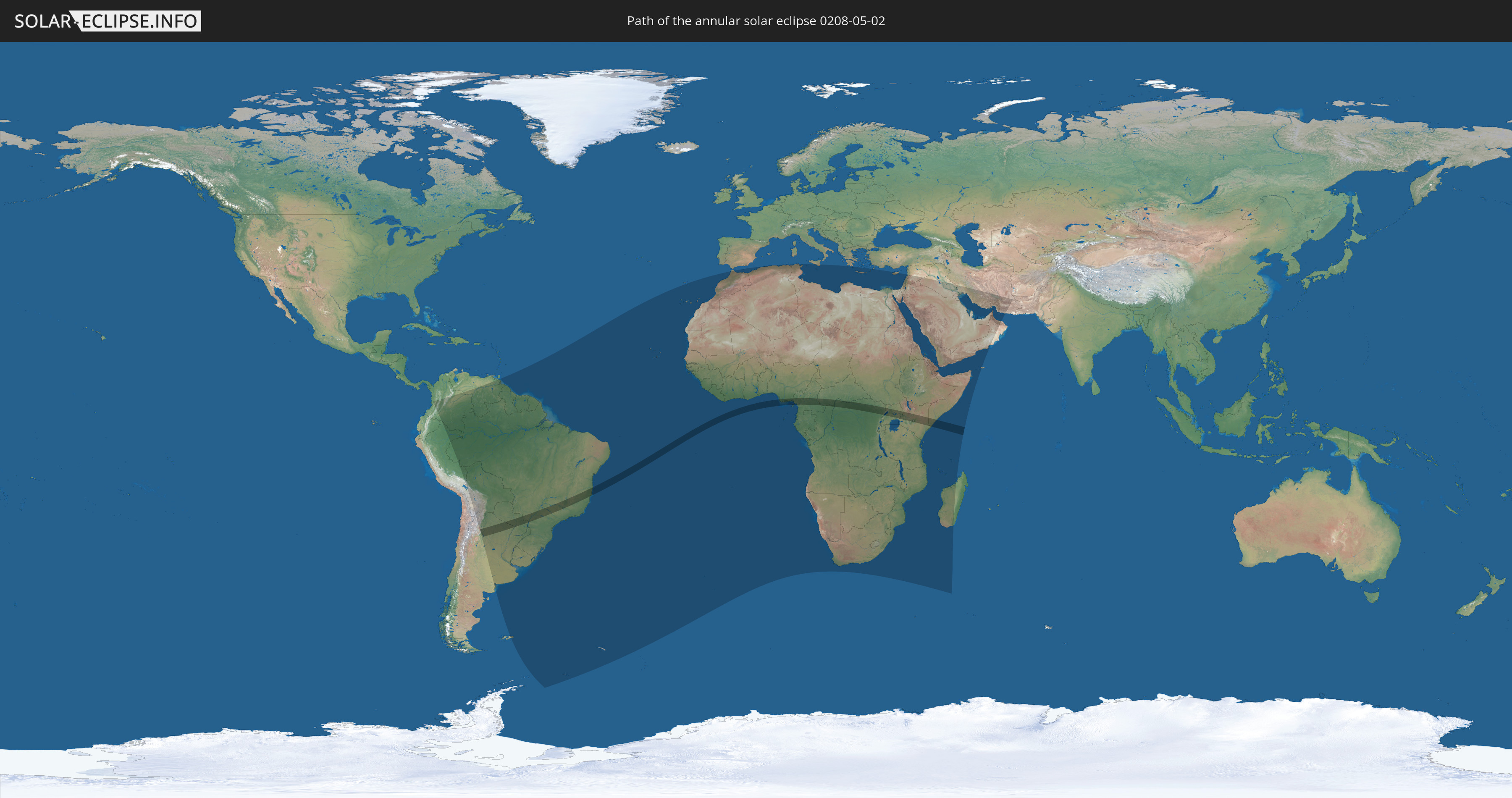
Die Sonnenfinsternis am 05/02/0208 kann man in 89 Ländern als partielle Sonnenfinsternis beobachten.
Der Finsternispfad verläuft durch 12 Länder. Nur in diesen Ländern ist sie als annular Sonnenfinsternis zu sehen.
In den folgenden Ländern ist die Sonnenfinsternis annular zu sehen
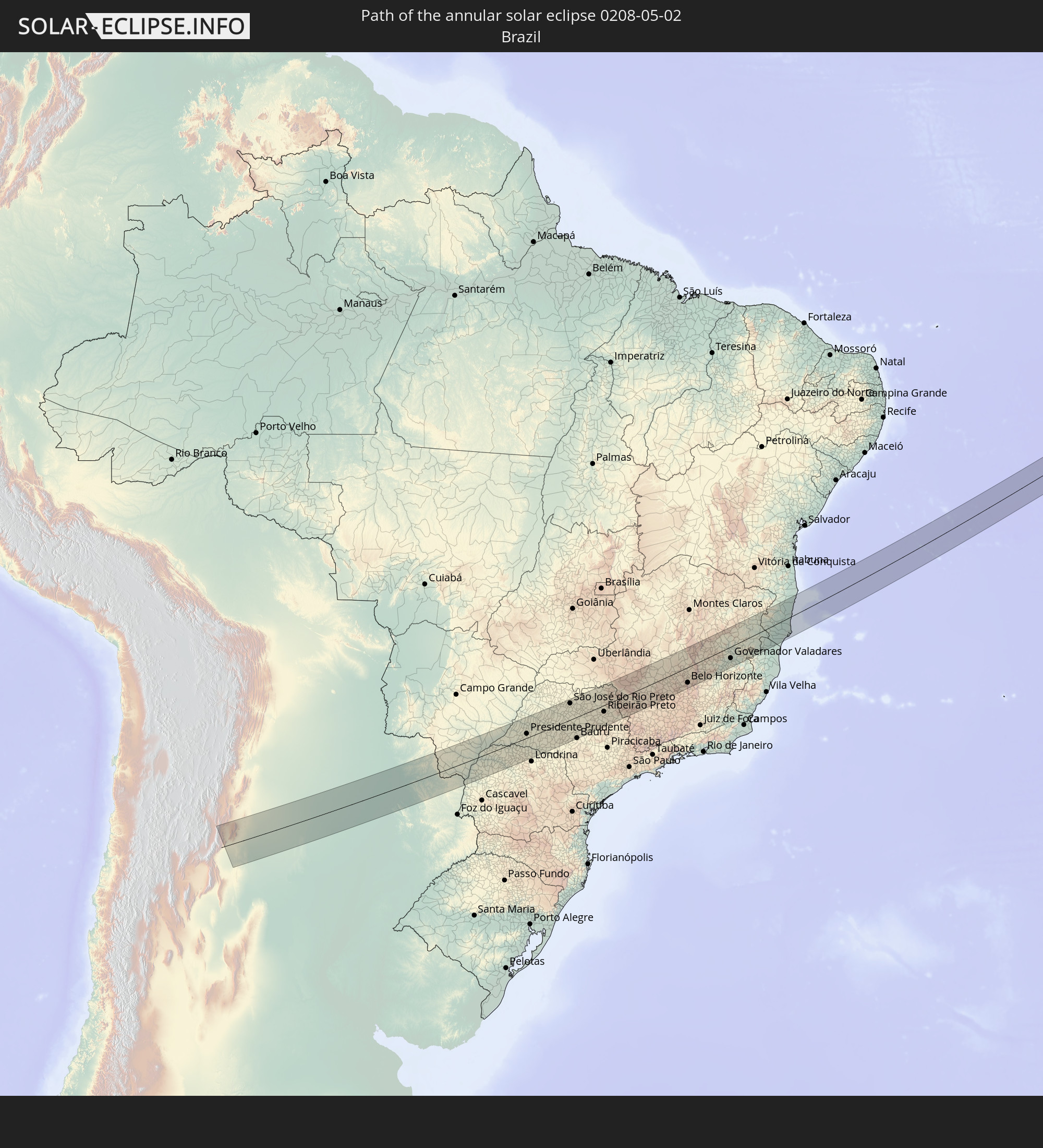 Brazil
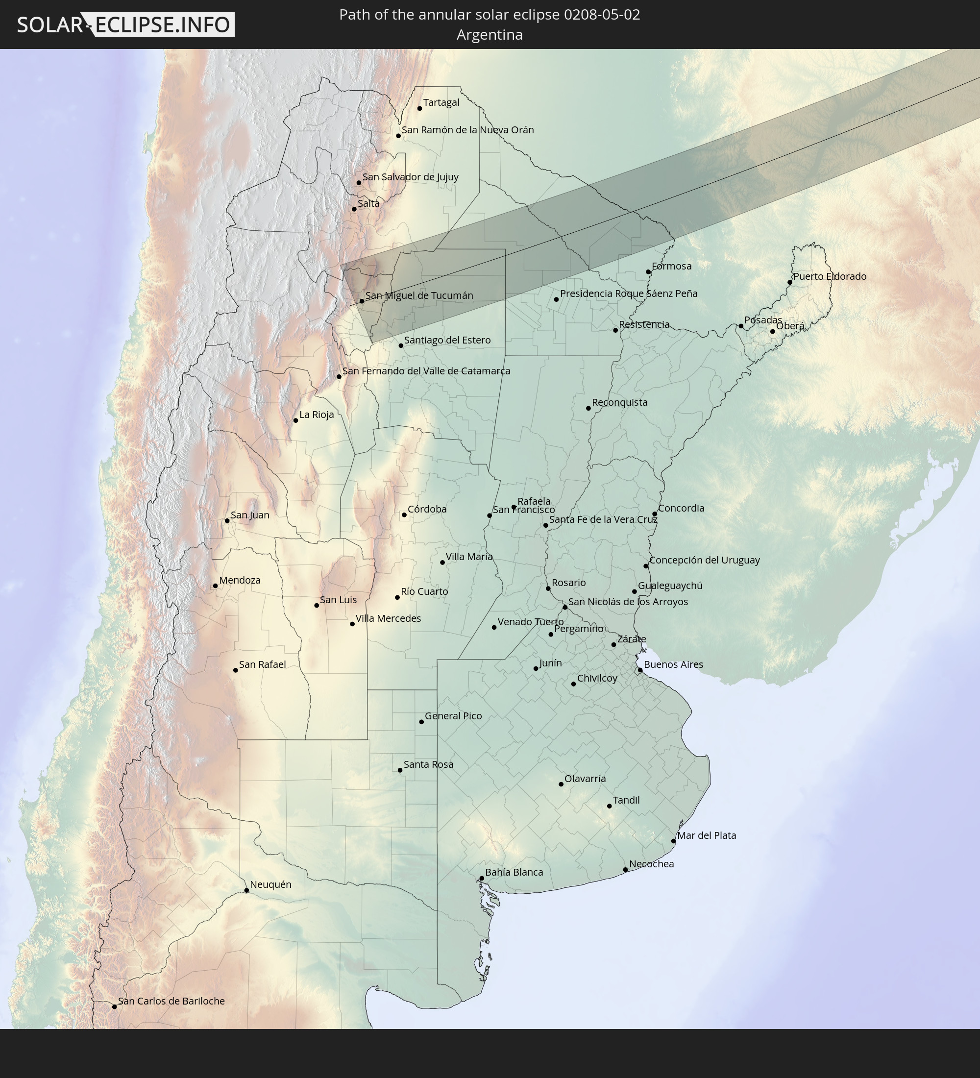 Argentina
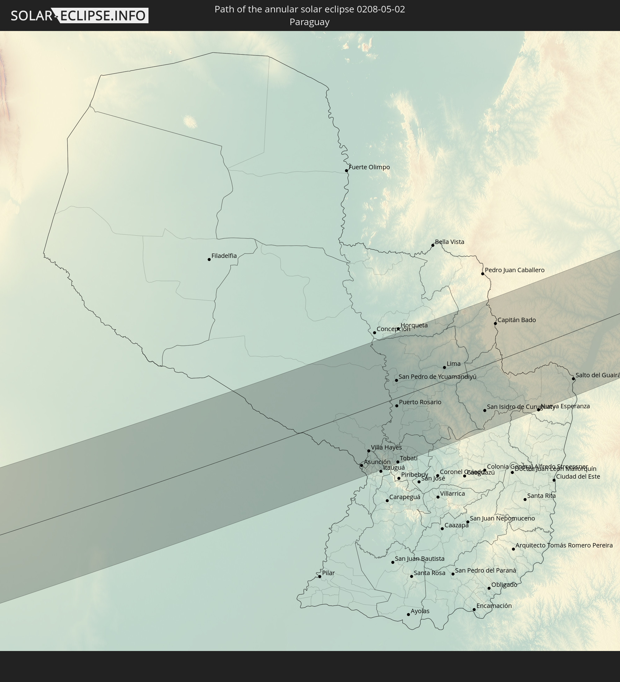 Paraguay
 Nigeria
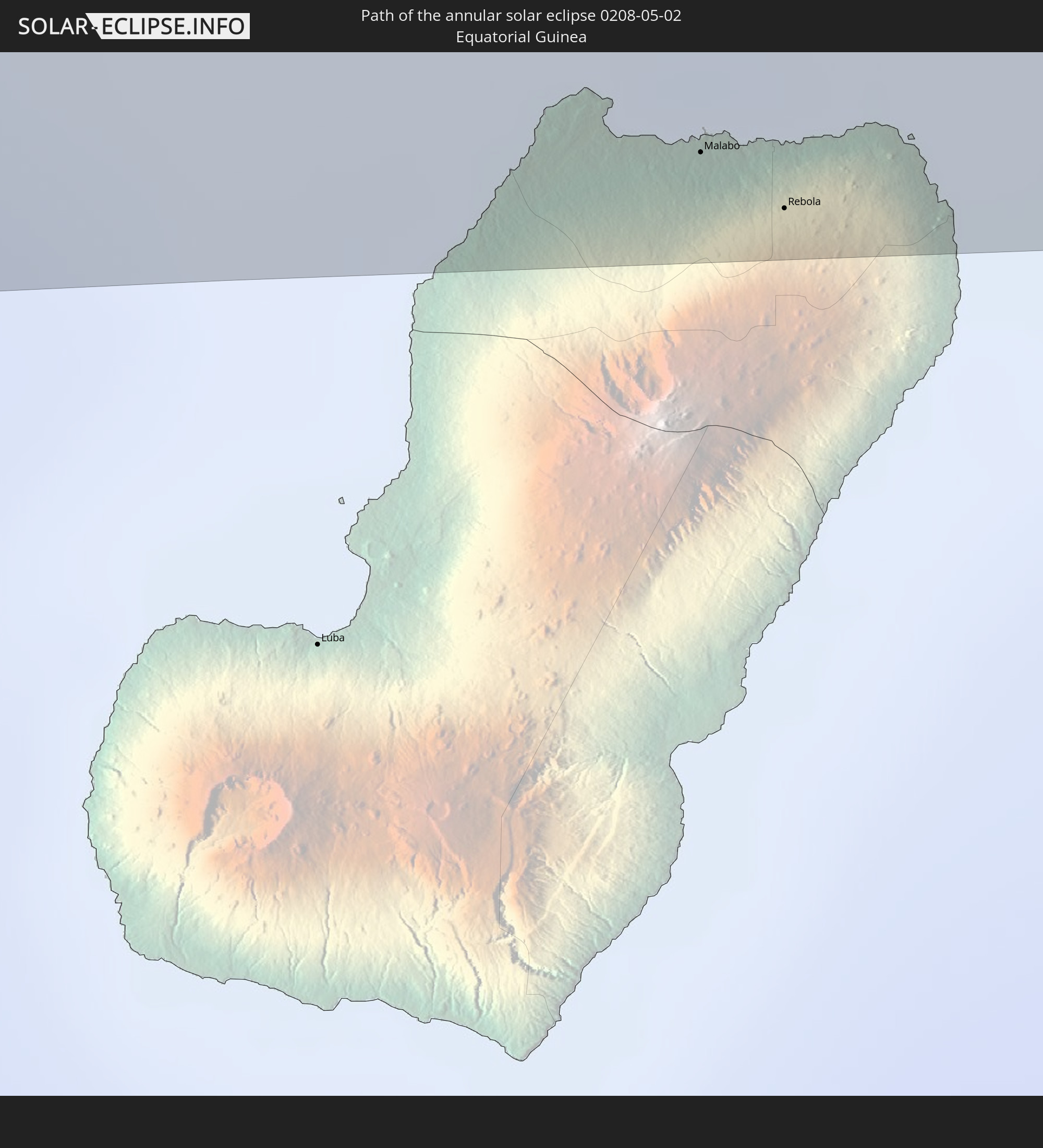 Equatorial Guinea
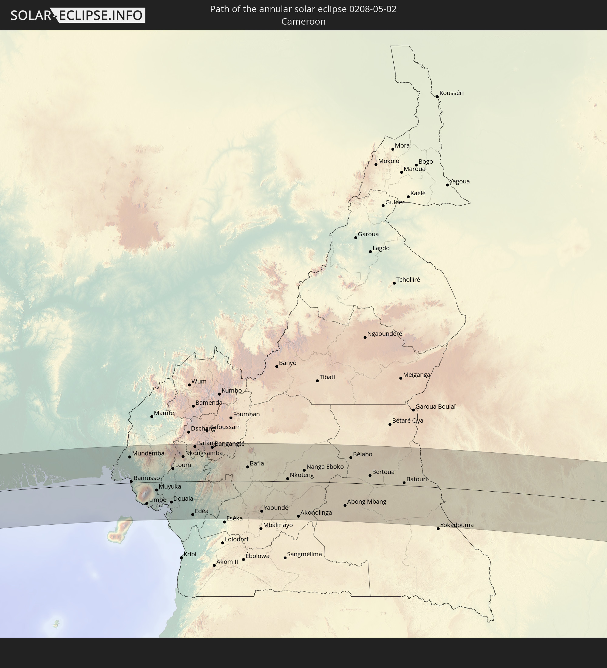 Cameroon
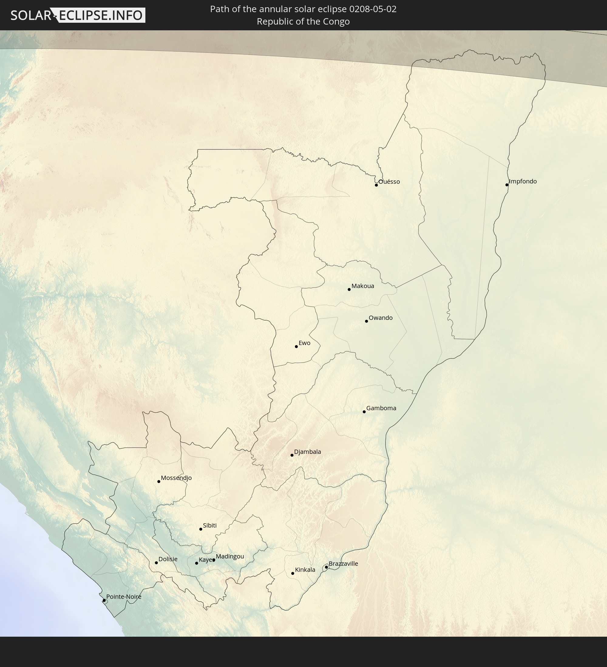 Republic of the Congo
 Democratic Republic of the Congo
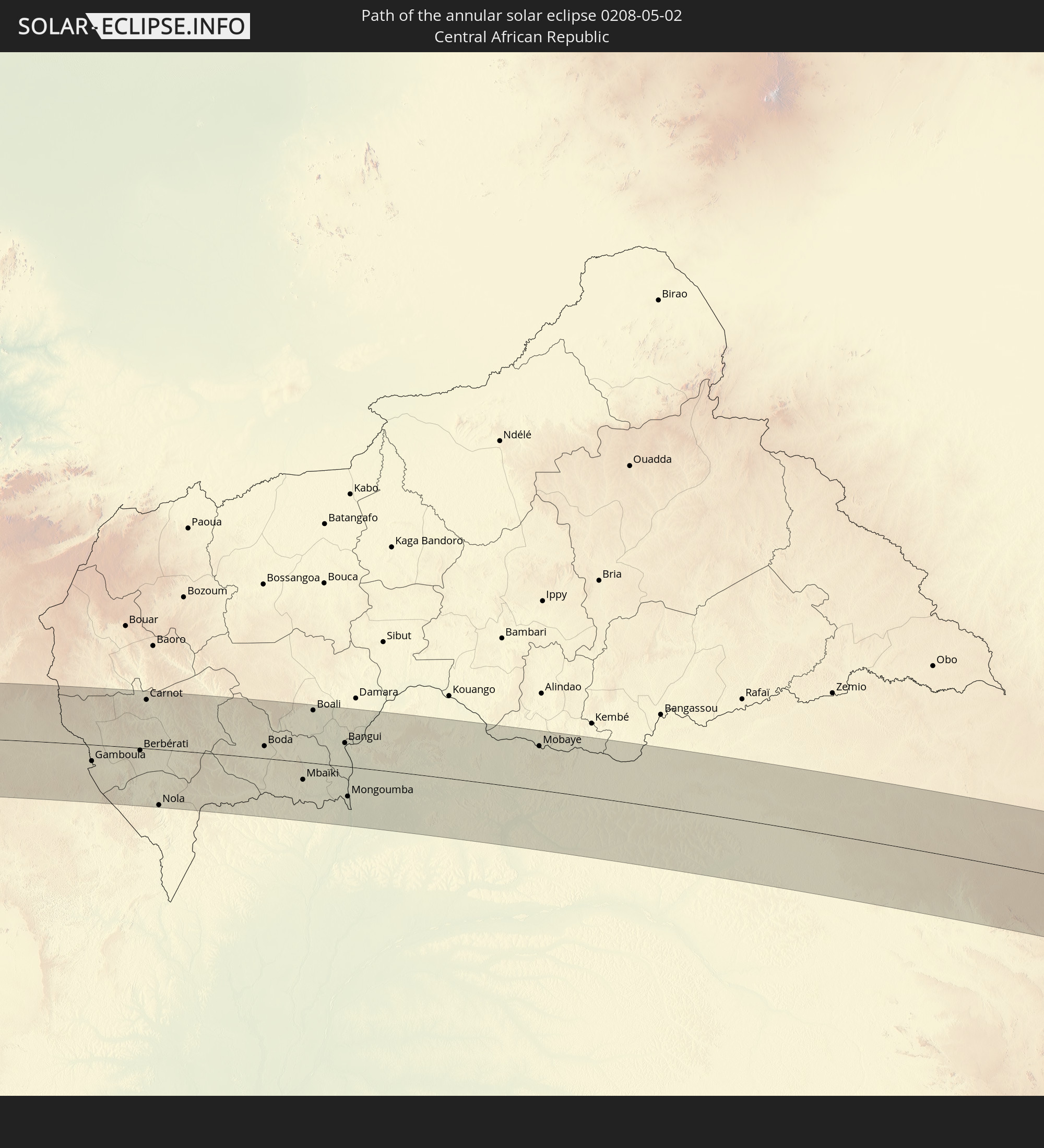 Central African Republic
 Uganda
 Kenya
Kenya
 Somalia
In den folgenden Ländern ist die Sonnenfinsternis partiell zu sehen
 Antarctica
 Colombia
 Peru
Peru
 Brazil
 Argentina
 Venezuela
 Bolivia
 Paraguay
 Falkland Islands
 Guyana
 Uruguay
 Suriname
 French Guiana
 South Georgia and the South Sandwich Islands
 Portugal
 Cabo Verde
 Spain
Spain
 Senegal
 Mauritania
 The Gambia
 Guinea-Bissau
 Guinea
 Saint Helena, Ascension and Tristan da Cunha
 Sierra Leone
 Morocco
 Mali
Mali
 Liberia
 Algeria
 Ivory Coast
 Burkina Faso
 Ghana
Ghana
 Togo
Togo
 Niger
Niger
 Benin
Benin
 Nigeria
 Equatorial Guinea
 São Tomé and Príncipe
 Italy
Italy
 Tunisia
 Cameroon
 Gabon
Gabon
 Libya
Libya
 Republic of the Congo
 Angola
 Namibia
 Democratic Republic of the Congo
 Chad
Chad
 Malta
Malta
 Central African Republic
 South Africa
 Greece
 Botswana
 Sudan
Sudan
 Zambia
 Egypt
Egypt
 Zimbabwe
 Lesotho
 Rwanda
 Burundi
 Tanzania
 Uganda
 Mozambique
 Swaziland
 Cyprus
 Malawi
 Ethiopia
 Kenya
Kenya
 State of Palestine
 Israel
 Saudi Arabia
 Jordan
 Lebanon
 Syria
Syria
 Eritrea
 Iraq
Iraq
 French Southern and Antarctic Lands
 Somalia
 Djibouti
 Yemen
Yemen
 Madagascar
 Comoros
 Iran
Iran
 Mayotte
 Seychelles
 Kuwait
 Bahrain
 Qatar
Qatar
 United Arab Emirates
 Oman
Oman
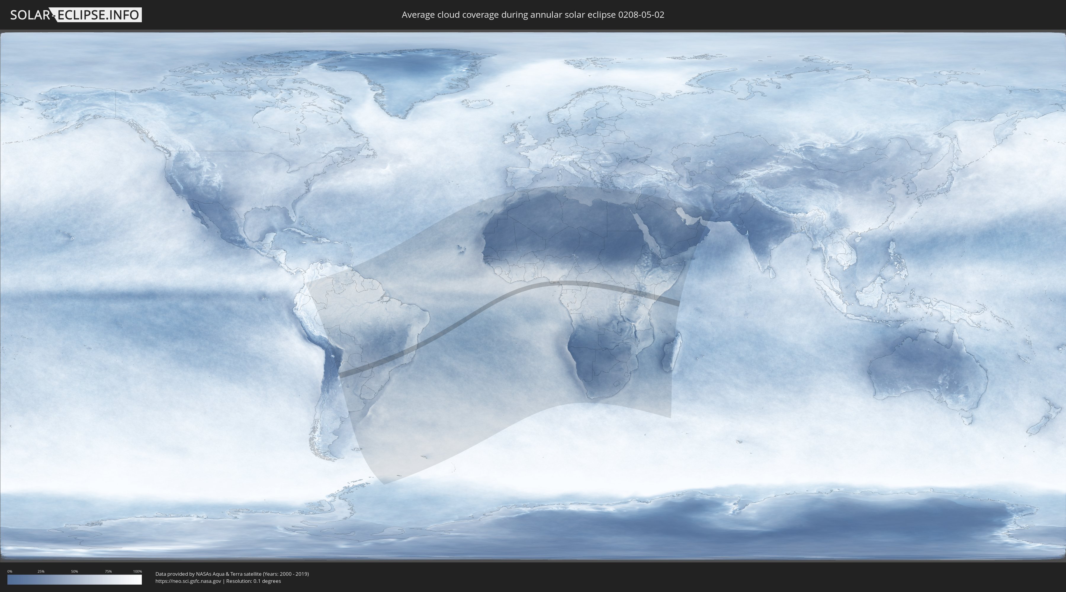
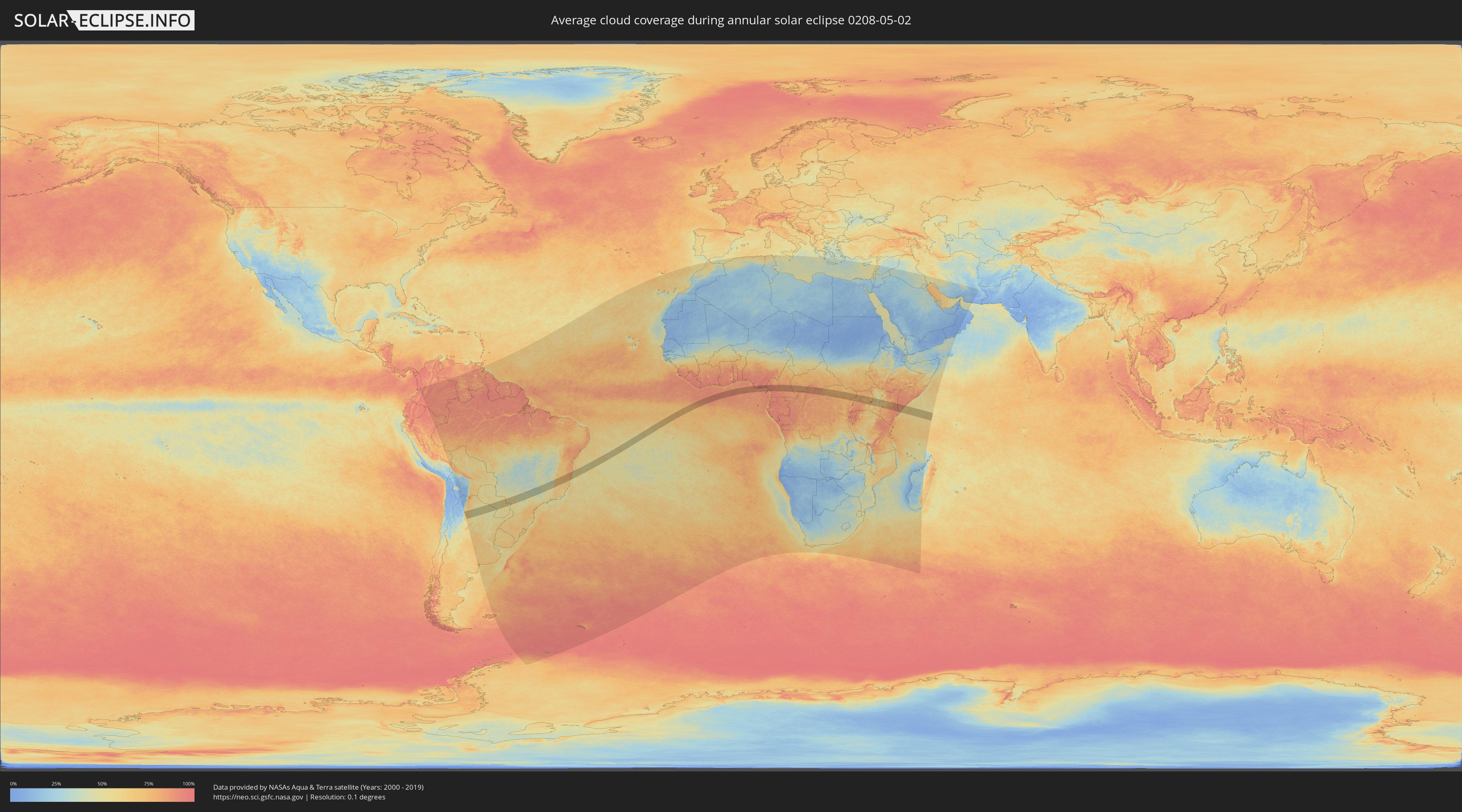
How will be the weather during the annular solar eclipse on 05/02/0208?
Where is the best place to see the annular solar eclipse of 05/02/0208?
The following maps show the average cloud coverage for the day of the annular solar eclipse.
With the help of these maps, it is possible to find the place along the eclipse path, which has the best
chance of a cloudless sky.
Nevertheless, you should consider local circumstances and inform about the weather of your chosen
observation site.
The data is provided by NASAs satellites
AQUA and TERRA.
The cloud maps are averaged over a period of 19 years (2000 - 2019).
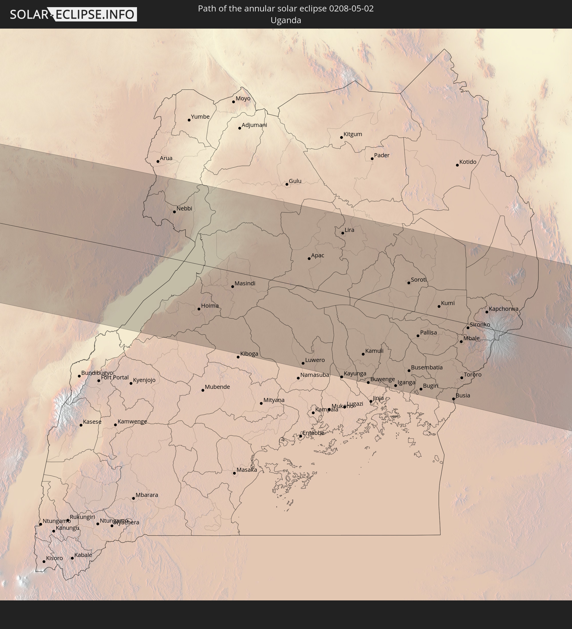
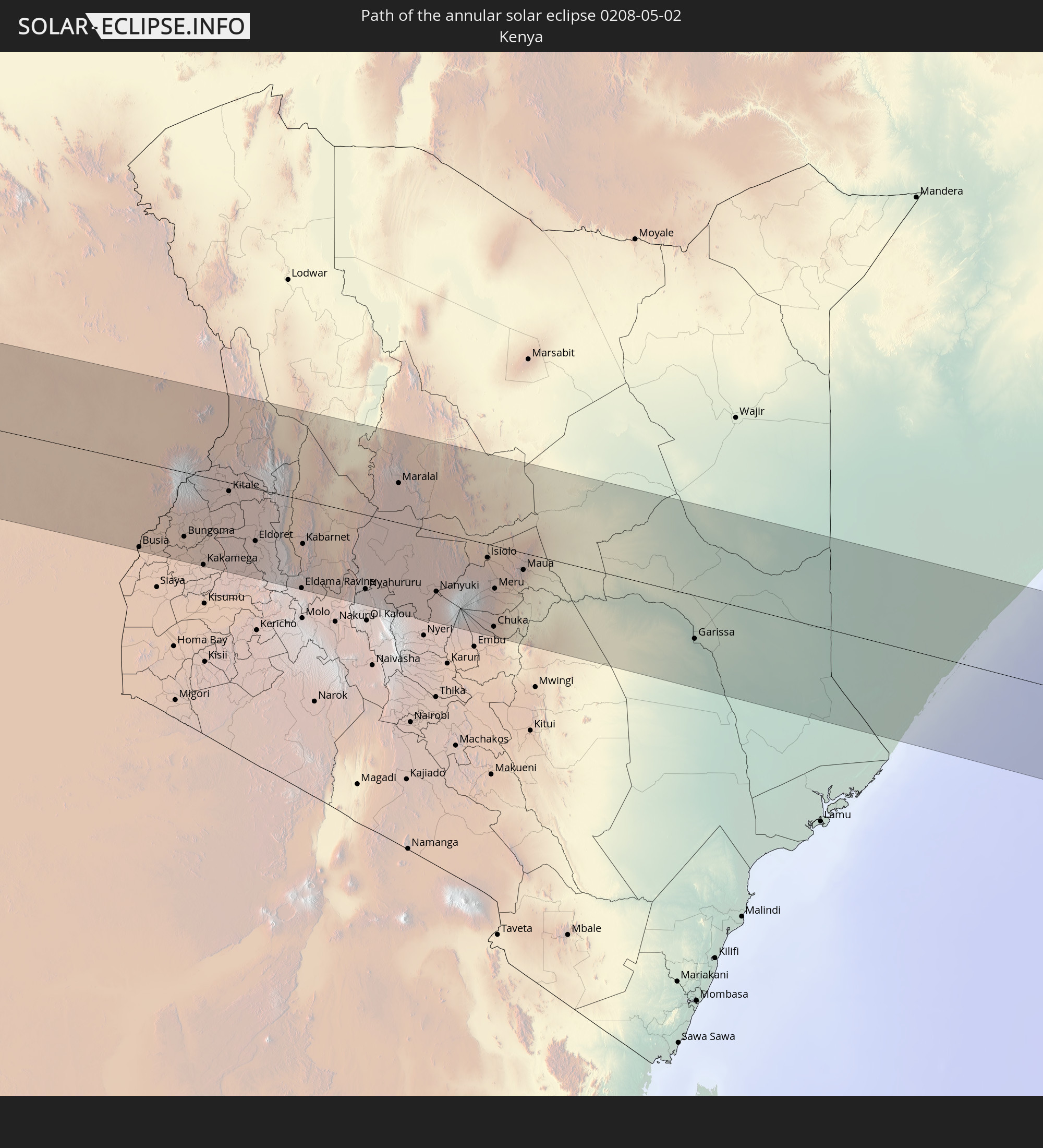
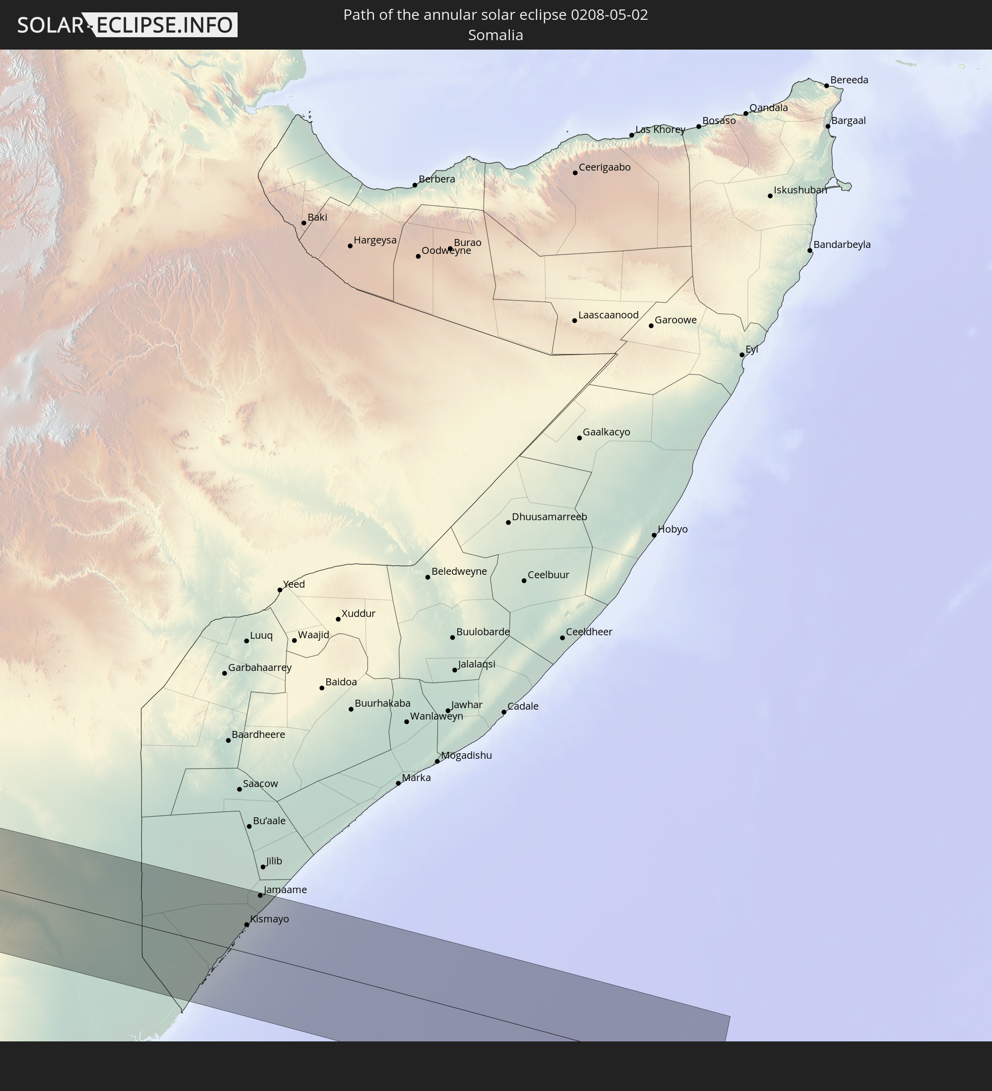
Detailed country maps
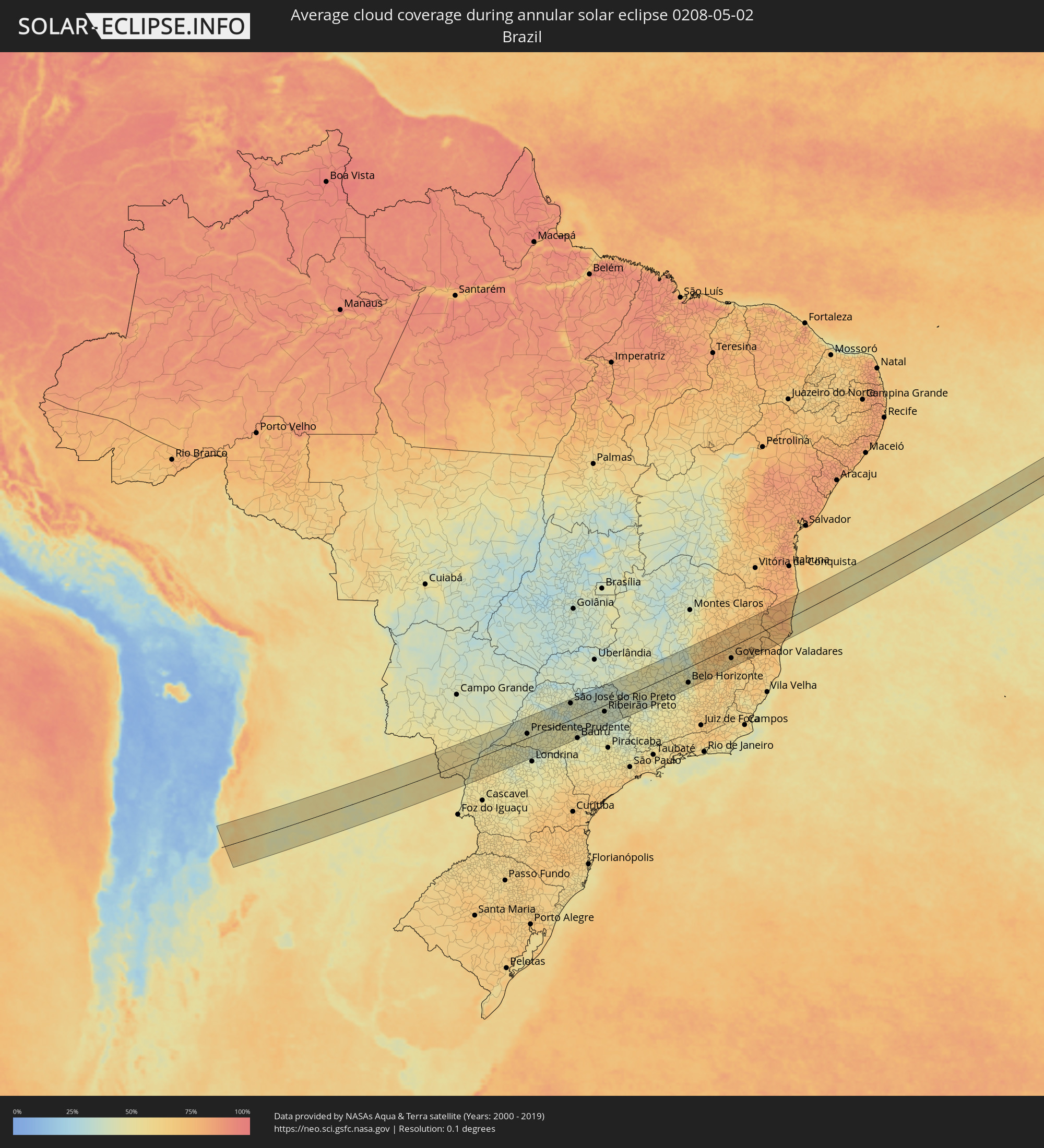 Brazil
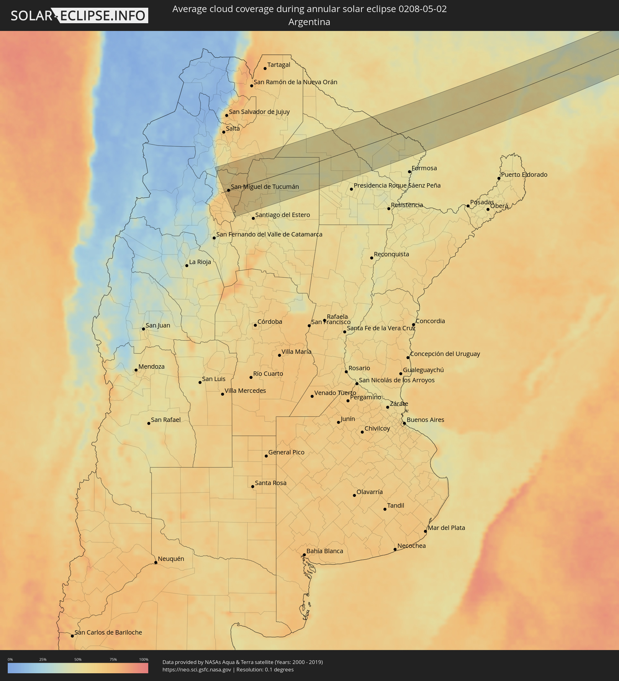 Argentina
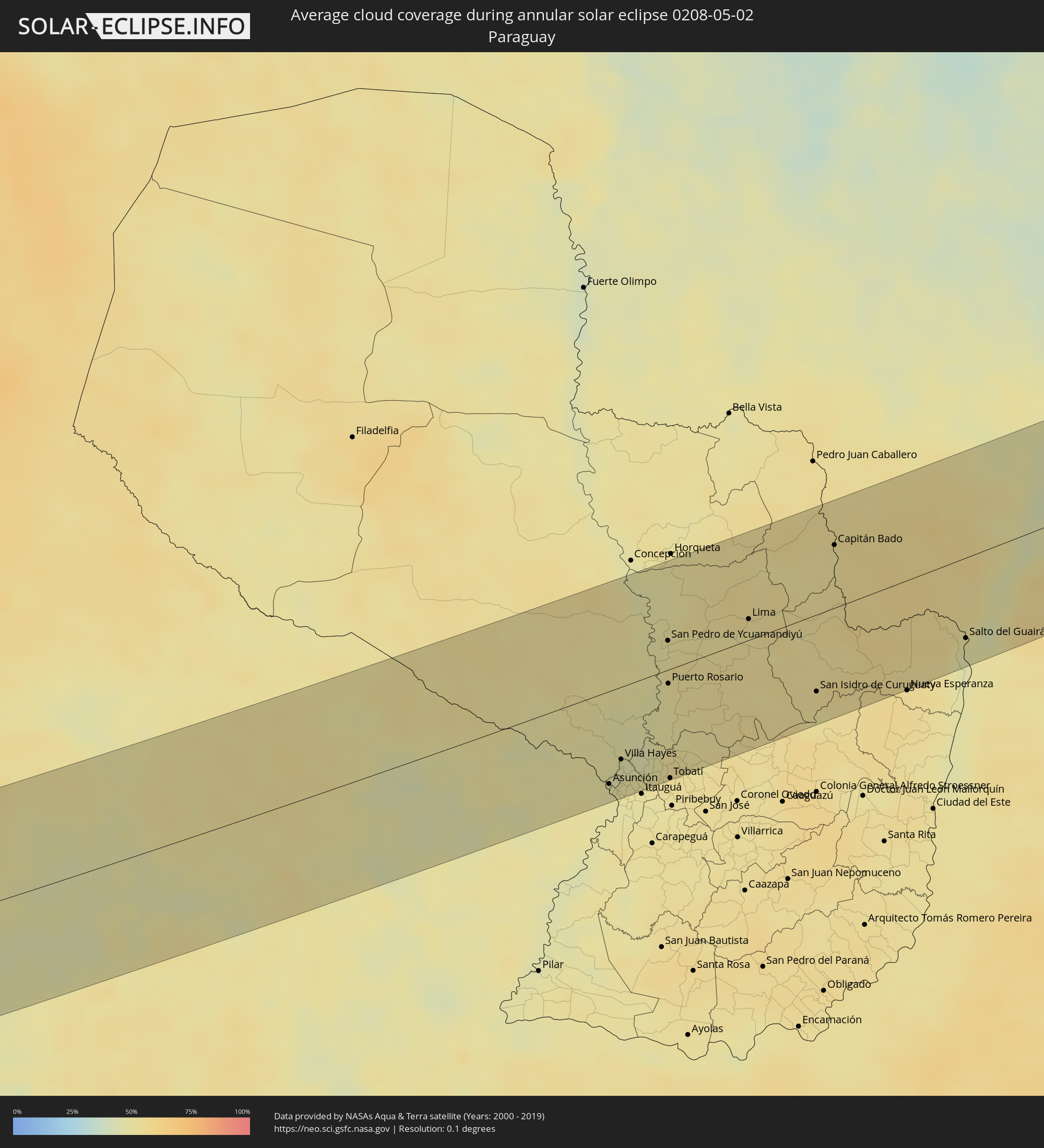 Paraguay
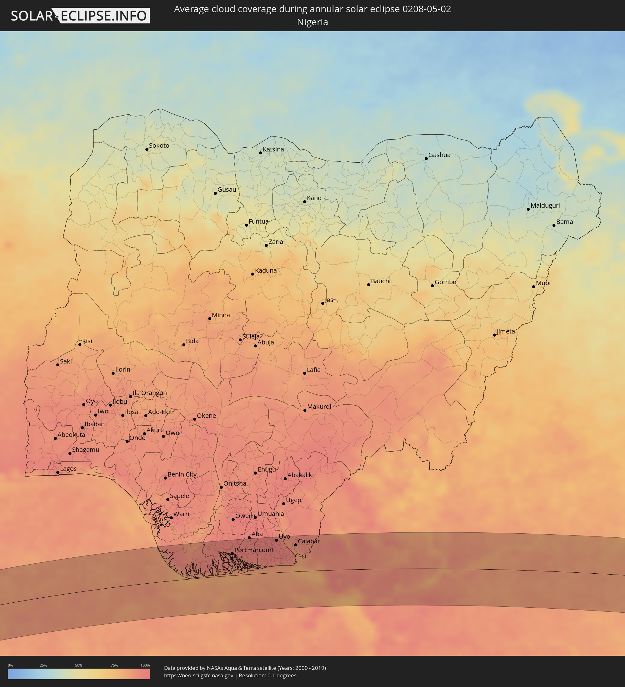 Nigeria
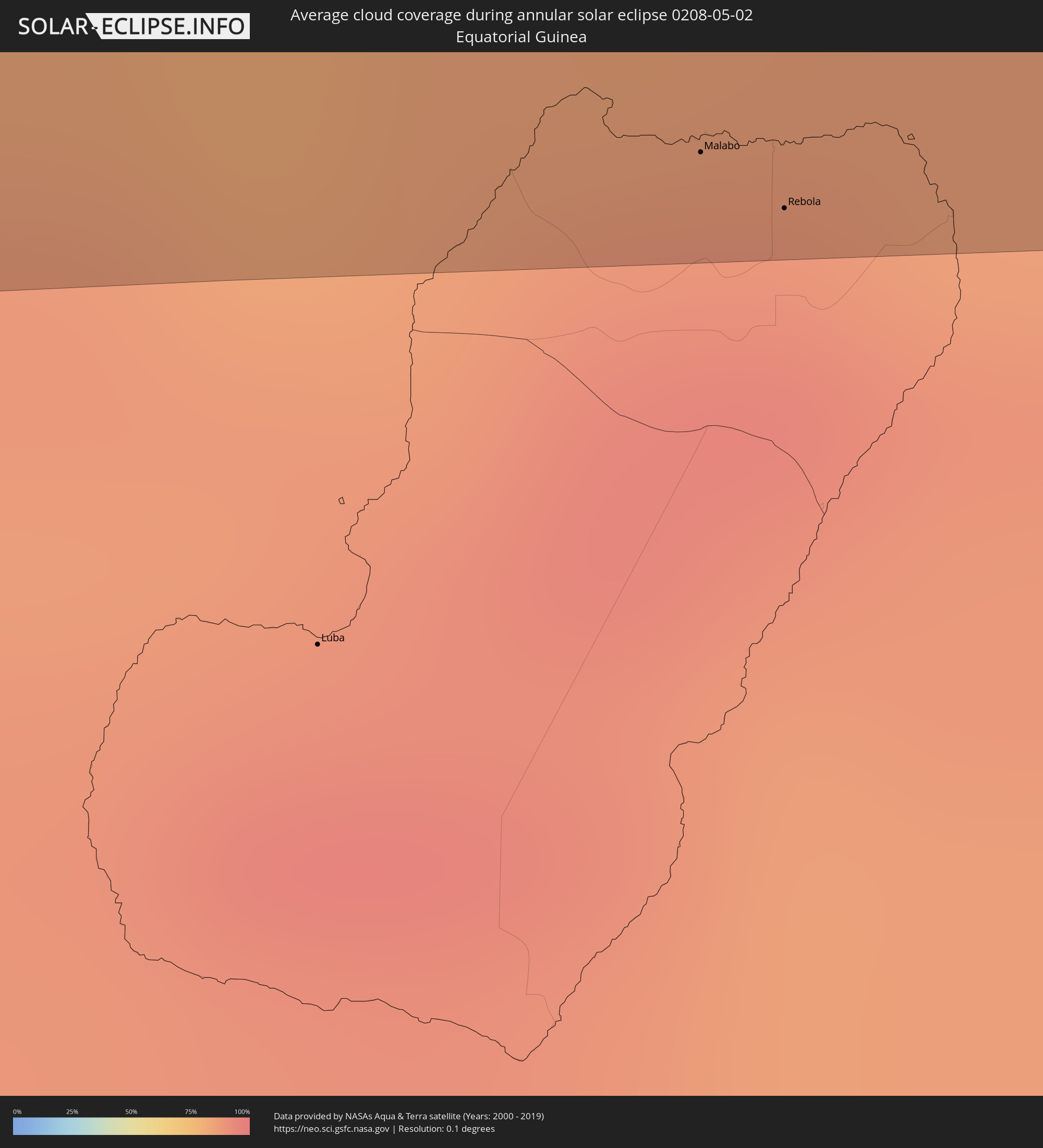 Equatorial Guinea
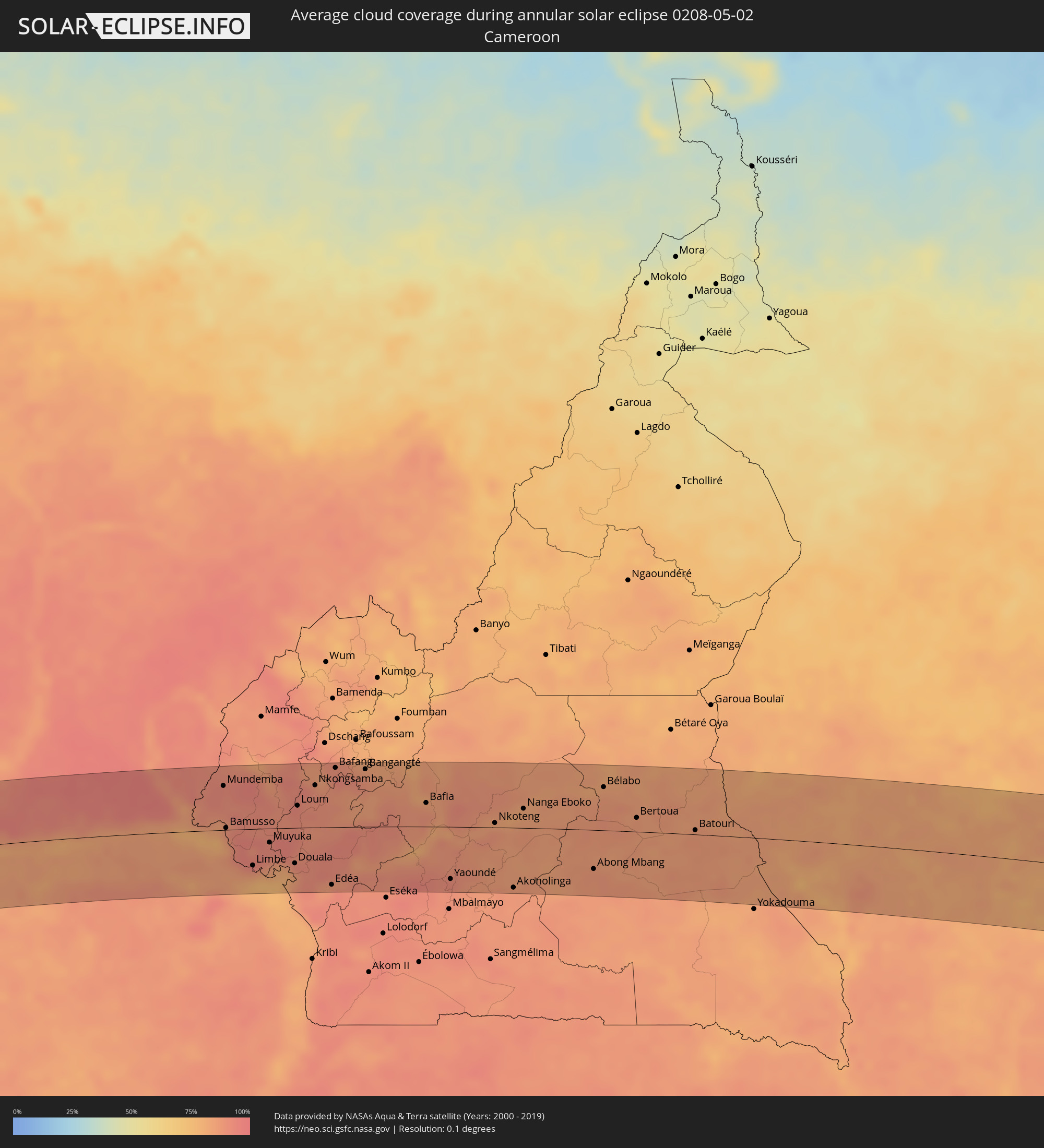 Cameroon
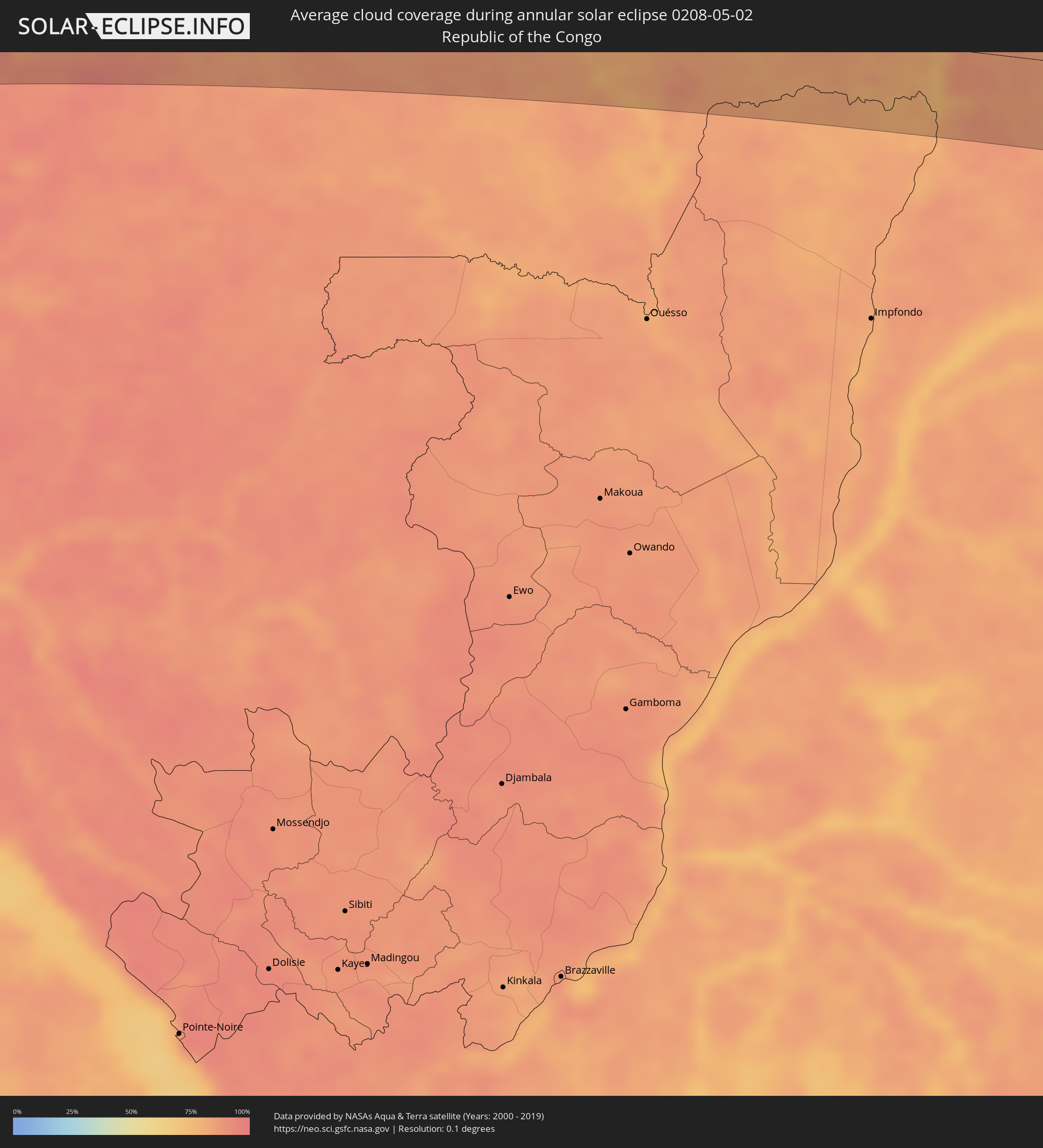 Republic of the Congo
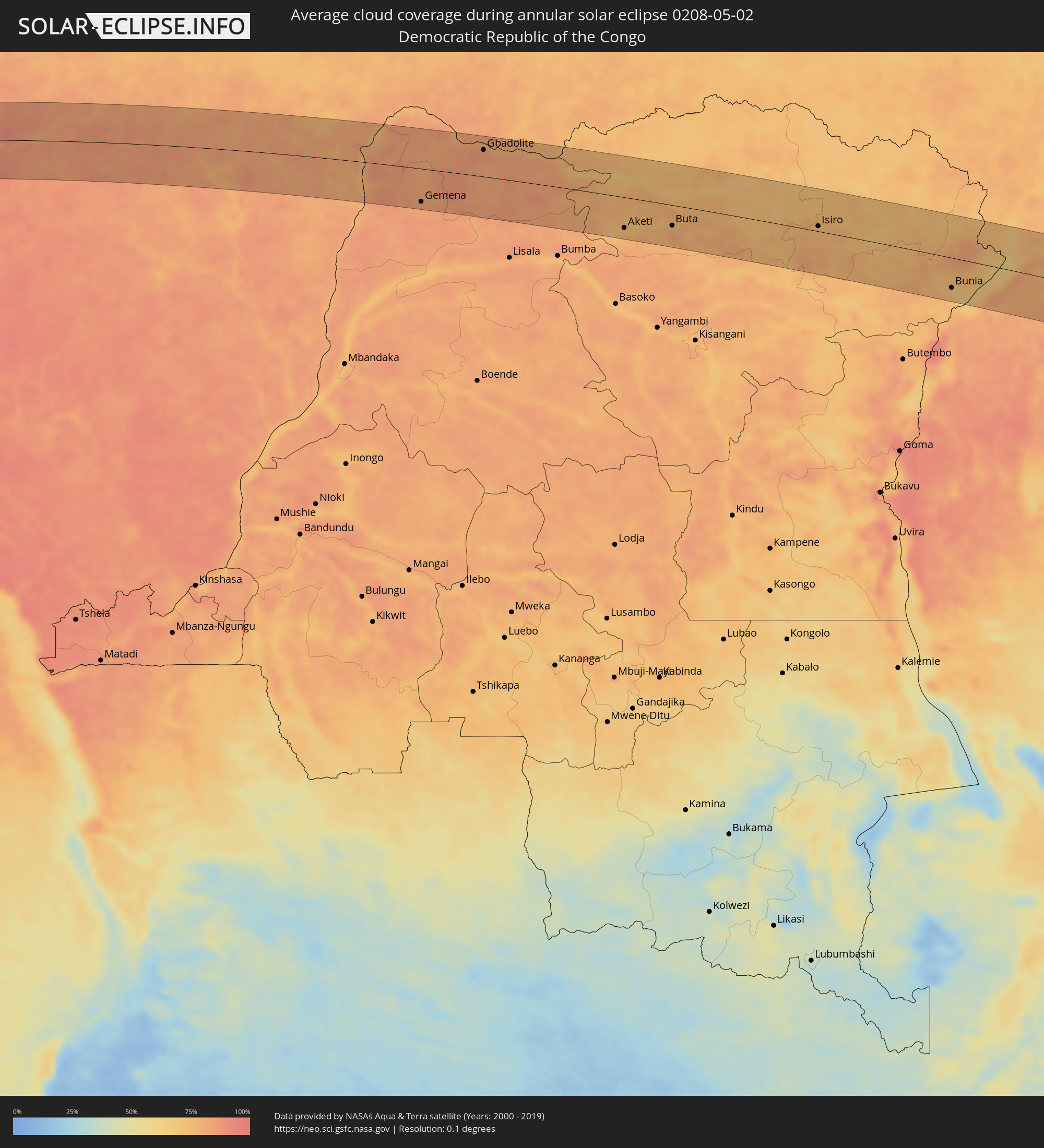 Democratic Republic of the Congo
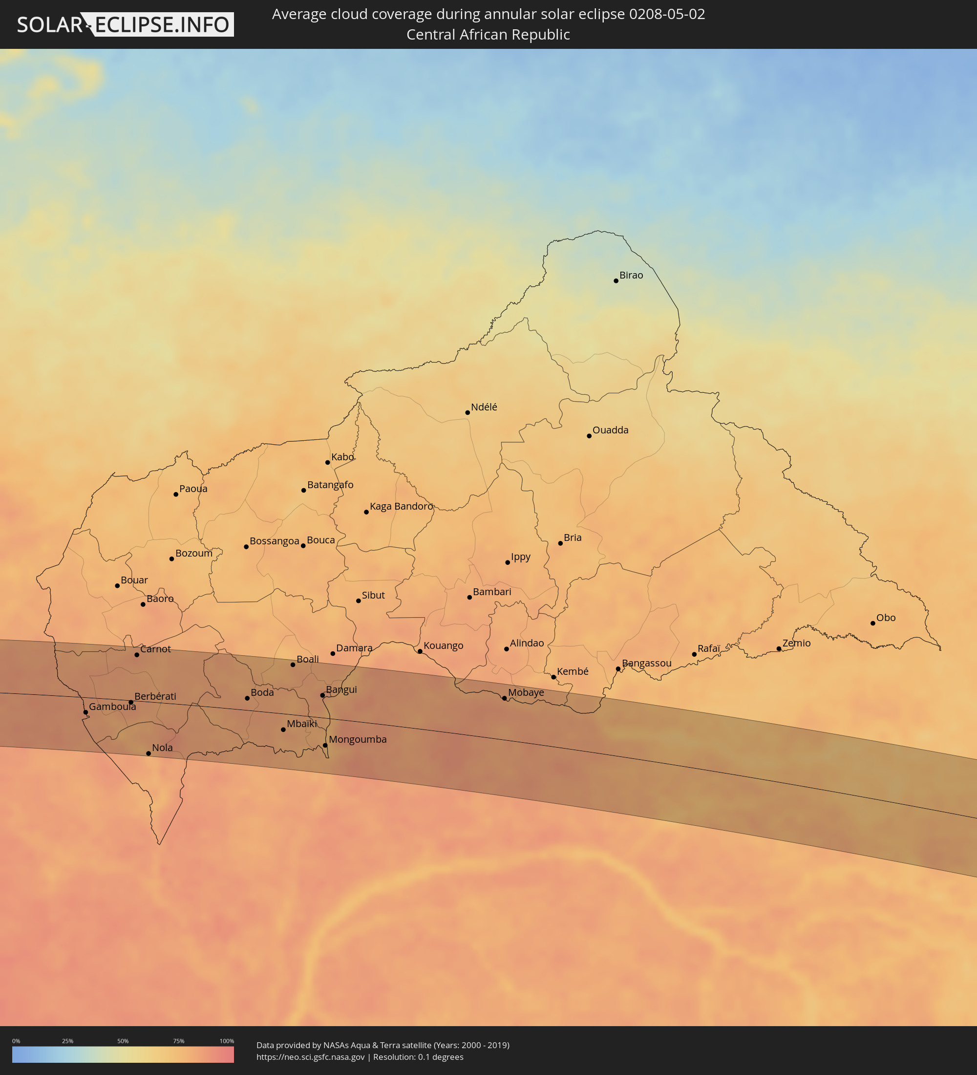 Central African Republic
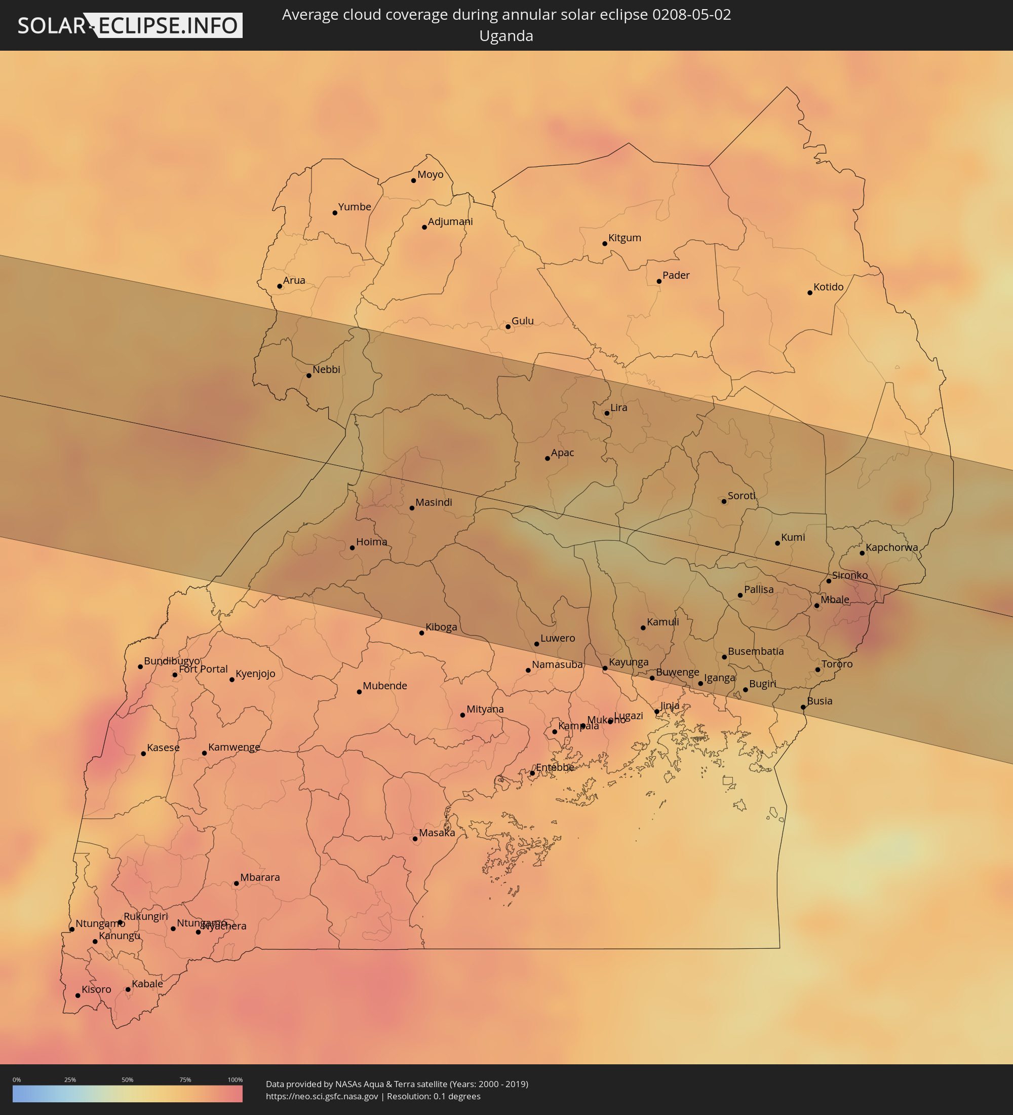 Uganda
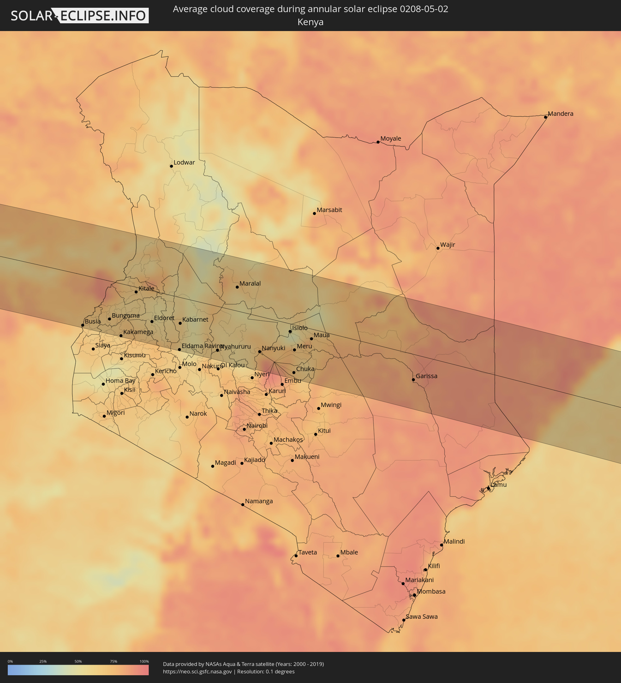 Kenya
Kenya
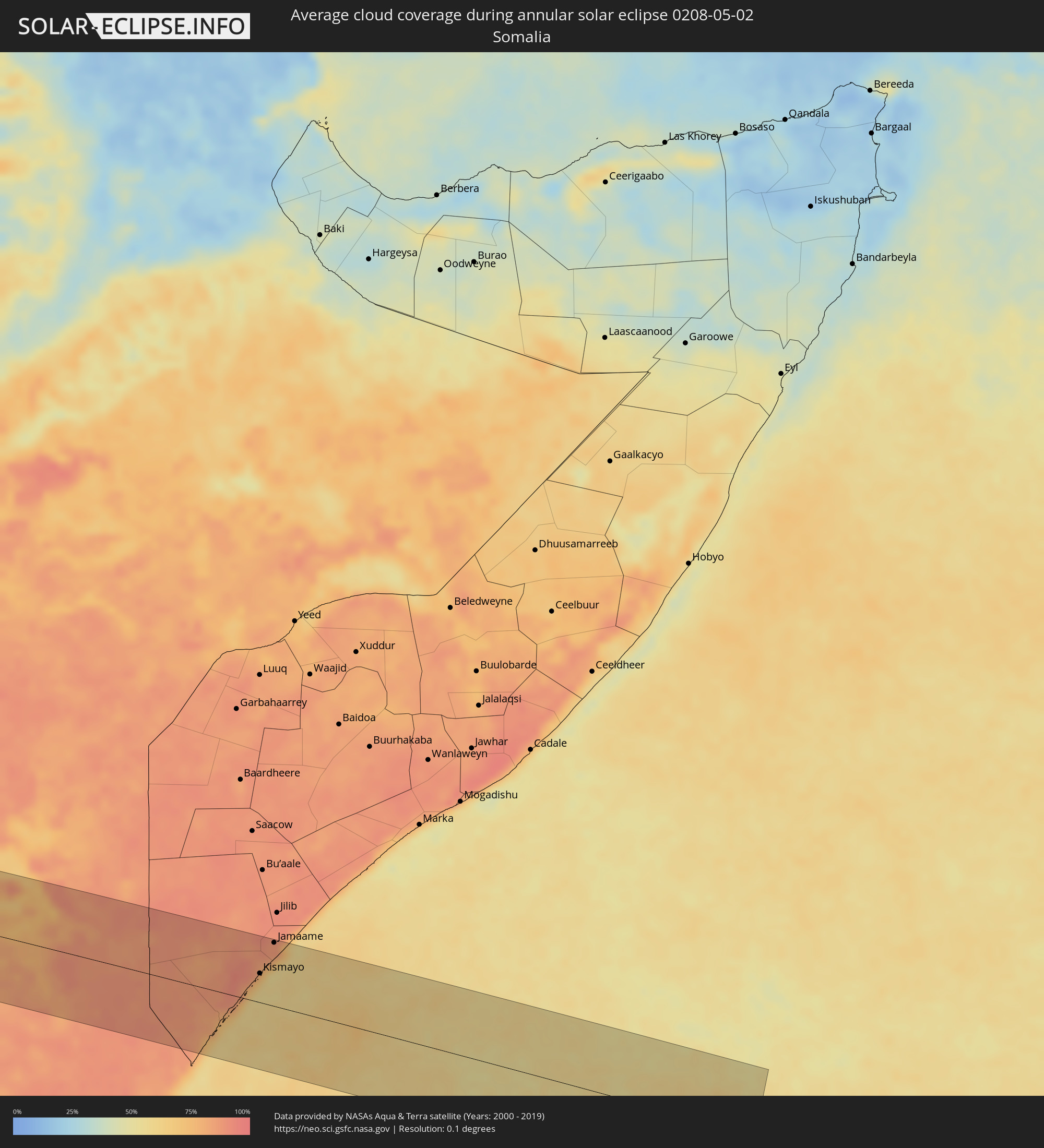 Somalia
Cities inside the path of the eclipse
The following table shows all locations with a population of more than 5,000 inside the eclipse path. Cities which have more than 100,000 inhabitants are marked bold. A click at the locations opens a detailed map.
| City | Type | Eclipse duration | Local time of max. eclipse | Distance to central line | Ø Cloud coverage |
|
Bella Vista, Tucumán Province
|
annular | - | 06:31:47 UTC-04:16 | 25 km | 66% |
|
Trancas, Tucumán Province
|
annular | - | 06:31:35 UTC-04:16 | 66 km | 54% |
|
Tafí Viejo, Tucumán Province
|
annular | - | 06:31:42 UTC-04:16 | 10 km | 65% |
|
San Miguel de Tucumán, Tucumán Province
|
annular | - | 06:31:44 UTC-04:16 | 1 km | 67% |
|
Alderetes, Tucumán Province
|
annular | - | 06:31:44 UTC-04:16 | 2 km | 68% |
|
Termas de Río Hondo, Santiago del Estero Province
|
annular | - | 06:31:57 UTC-04:16 | 82 km | 55% |
|
Taco Pozo, Chaco Province
|
annular | - | 06:31:40 UTC-04:16 | 69 km | 51% |
|
Campo Gallo, Santiago del Estero Province
|
annular | - | 06:31:57 UTC-04:16 | 47 km | 46% |
|
Los Frentones, Chaco Province
|
annular | - | 06:32:10 UTC-04:16 | 74 km | 49% |
|
Pampa del Infierno, Chaco Province
|
annular | - | 06:32:14 UTC-04:16 | 91 km | 48% |
|
Castelli, Chaco Province
|
annular | - | 06:32:14 UTC-04:16 | 50 km | 55% |
|
Las Lomitas, Formosa Province
|
annular | - | 06:32:01 UTC-04:16 | 79 km | 52% |
|
Tres Isletas, Chaco Province
|
annular | - | 06:32:22 UTC-04:16 | 98 km | 51% |
|
Pampa del Indio, Chaco Province
|
annular | - | 06:32:26 UTC-04:16 | 86 km | 50% |
|
Ibarreta, Formosa Province
|
annular | - | 06:32:17 UTC-04:16 | 2 km | 48% |
|
Comandante Fontana, Formosa Province
|
annular | - | 06:32:21 UTC-04:16 | 17 km | 45% |
|
Palo Santo, Formosa Province
|
annular | - | 06:32:29 UTC-04:16 | 52 km | 45% |
|
Pirané, Formosa Province
|
annular | - | 06:32:35 UTC-04:16 | 78 km | 47% |
|
Clorinda, Formosa Province
|
annular | - | 06:32:55 UTC-04:16 | 78 km | 48% |
|
Nanawa, Presidente Hayes
|
annular | - | 06:59:04 UTC-03:50 | 78 km | 48% |
|
Asunción, Asunción
|
annular | - | 06:59:05 UTC-03:50 | 82 km | 48% |
|
Villa Elisa, Central
|
annular | - | 06:59:07 UTC-03:50 | 91 km | 47% |
|
Benjamín Aceval, Presidente Hayes
|
annular | - | 06:59:03 UTC-03:50 | 50 km | 48% |
|
Colonia Mariano Roque Alonso, Central
|
annular | - | 06:59:06 UTC-03:50 | 71 km | 48% |
|
San Antonio, Central
|
annular | - | 06:59:08 UTC-03:50 | 98 km | 47% |
|
Nemby, Central
|
annular | - | 06:59:08 UTC-03:50 | 96 km | 47% |
|
Villa Hayes, Presidente Hayes
|
annular | - | 06:59:05 UTC-03:50 | 64 km | 47% |
|
Fernando de la Mora, Central
|
annular | - | 06:59:08 UTC-03:50 | 90 km | 49% |
|
Limpio, Central
|
annular | - | 06:59:07 UTC-03:50 | 73 km | 49% |
|
Capiatá, Central
|
annular | - | 06:59:09 UTC-03:50 | 95 km | 48% |
|
Areguá, Central
|
annular | - | 06:59:10 UTC-03:50 | 92 km | 49% |
|
Emboscada, Cordillera
|
annular | - | 06:59:09 UTC-03:50 | 76 km | 50% |
|
San Pedro de Ycuamandiyú, San Pedro
|
annular | - | 06:59:07 UTC-03:50 | 26 km | 49% |
|
Tobatí, Cordillera
|
annular | - | 06:59:16 UTC-03:50 | 97 km | 51% |
|
Lima, San Pedro
|
annular | - | 06:59:22 UTC-03:50 | 19 km | 52% |
|
San Isidro de Curuguaty, Canindeyú
|
annular | - | 06:59:41 UTC-03:50 | 68 km | 54% |
|
Capitán Bado, Amambay
|
annular | - | 06:59:39 UTC-03:50 | 56 km | 53% |
|
Salto del Guairá, Canindeyú
|
annular | - | 07:00:15 UTC-03:50 | 71 km | 46% |
|
Maringá, Paraná
|
annular | - | 07:45:36 UTC-03:06 | 94 km | 46% |
|
Presidente Prudente, São Paulo
|
annular | - | 07:45:55 UTC-03:06 | 19 km | 45% |
|
Araçatuba, São Paulo
|
annular | - | 07:46:33 UTC-03:06 | 75 km | 43% |
|
Marília, São Paulo
|
annular | - | 07:46:48 UTC-03:06 | 47 km | 47% |
|
São José do Rio Preto, São Paulo
|
annular | - | 07:47:17 UTC-03:06 | 73 km | 42% |
|
Bauru, São Paulo
|
annular | - | 07:47:23 UTC-03:06 | 93 km | 47% |
|
Araraquara, São Paulo
|
annular | - | 07:48:03 UTC-03:06 | 76 km | 42% |
|
Ribeirão Preto, São Paulo
|
annular | - | 07:48:22 UTC-03:06 | 28 km | 42% |
|
Franca, São Paulo
|
annular | - | 07:48:46 UTC-03:06 | 20 km | 40% |
|
Divinópolis, Minas Gerais
|
annular | - | 07:50:56 UTC-03:06 | 48 km | 48% |
|
Sete Lagoas, Minas Gerais
|
annular | - | 07:51:41 UTC-03:06 | 8 km | 50% |
|
Betim, Minas Gerais
|
annular | - | 07:51:36 UTC-03:06 | 61 km | 44% |
|
Ribeirão das Neves, Minas Gerais
|
annular | - | 07:51:45 UTC-03:06 | 45 km | 49% |
|
Ibirité, Minas Gerais
|
annular | - | 07:51:43 UTC-03:06 | 72 km | 45% |
|
Belo Horizonte, Minas Gerais
|
annular | - | 07:51:52 UTC-03:06 | 68 km | 48% |
|
Santa Luzia, Minas Gerais
|
annular | - | 07:51:59 UTC-03:06 | 56 km | 49% |
|
Ipatinga, Minas Gerais
|
annular | - | 07:53:21 UTC-03:06 | 85 km | 51% |
|
Governador Valadares, Minas Gerais
|
annular | - | 07:54:08 UTC-03:06 | 50 km | 63% |
|
Porto Seguro, Bahia
|
annular | - | 08:30:53 UTC-02:34 | 52 km | 60% |
|
Amassoma, Bayelsa
|
annular | - | 13:51:20 UTC+00:13 | 79 km | 86% |
|
Twon-Brass, Bayelsa
|
annular | - | 13:51:14 UTC+00:13 | 5 km | 79% |
|
Yenagoa, Bayelsa
|
annular | - | 13:51:47 UTC+00:13 | 73 km | 91% |
|
Degema Hulk, Rivers
|
annular | - | 13:53:07 UTC+00:13 | 50 km | 93% |
|
Obonoma, Rivers
|
annular | - | 13:53:12 UTC+00:13 | 44 km | 93% |
|
Buguma, Rivers
|
annular | - | 13:53:26 UTC+00:13 | 46 km | 94% |
|
Port Harcourt, Rivers
|
annular | - | 13:53:55 UTC+00:13 | 49 km | 94% |
|
Okrika, Rivers
|
annular | - | 13:54:06 UTC+00:13 | 45 km | 93% |
|
Bonny, Rivers
|
annular | - | 13:54:09 UTC+00:13 | 12 km | 88% |
|
Bori, Rivers
|
annular | - | 13:54:54 UTC+00:13 | 35 km | 95% |
|
Abak, Akwa Ibom
|
annular | - | 13:56:21 UTC+00:13 | 67 km | 97% |
|
Etinan, Akwa Ibom
|
annular | - | 13:56:27 UTC+00:13 | 51 km | 96% |
|
Eket, Akwa Ibom
|
annular | - | 13:56:31 UTC+00:13 | 28 km | 86% |
|
Uyo, Akwa Ibom
|
annular | - | 13:56:49 UTC+00:13 | 73 km | 97% |
|
Akankpa, Cross River
|
annular | - | 13:57:37 UTC+00:13 | 80 km | 90% |
|
Esuk Oron, Akwa Ibom
|
annular | - | 13:57:35 UTC+00:13 | 44 km | 89% |
|
Calabar, Cross River
|
annular | - | 13:57:54 UTC+00:13 | 61 km | 91% |
|
Ikang, Cross River
|
annular | - | 13:58:22 UTC+00:13 | 41 km | 87% |
|
Malabo, Bioko Norte
|
annular | - | 13:58:25 UTC+00:13 | 76 km | 89% |
|
Rebola, Bioko Norte
|
annular | - | 13:58:32 UTC+00:13 | 80 km | 94% |
|
Limbe, South-West
|
annular | - | 13:59:49 UTC+00:13 | 47 km | 84% |
|
Tiko, South-West
|
annular | - | 14:00:16 UTC+00:13 | 42 km | 86% |
|
Muyuka, South-West
|
annular | - | 14:00:32 UTC+00:13 | 18 km | 93% |
|
Kumba, South-West
|
annular | - | 14:00:51 UTC+00:13 | 20 km | 91% |
|
Mbanga, Littoral
|
annular | - | 14:01:06 UTC+00:13 | 5 km | 92% |
|
Douala, Littoral
|
annular | - | 14:01:13 UTC+00:13 | 46 km | 84% |
|
Loum, Littoral
|
annular | - | 14:01:42 UTC+00:13 | 29 km | 92% |
|
Manjo, Littoral
|
annular | - | 14:02:01 UTC+00:13 | 42 km | 91% |
|
Nkongsamba, Littoral
|
annular | - | 14:02:24 UTC+00:13 | 54 km | 90% |
|
Melong, Littoral
|
annular | - | 14:02:33 UTC+00:13 | 73 km | 84% |
|
Edéa, Littoral
|
annular | - | 14:02:15 UTC+00:13 | 74 km | 88% |
|
Bafang, West
|
annular | - | 14:03:09 UTC+00:13 | 77 km | 90% |
|
Bangangté, West
|
annular | - | 14:04:05 UTC+00:13 | 74 km | 88% |
|
Bafia, Centre
|
annular | - | 14:05:44 UTC+00:13 | 31 km | 86% |
|
Yaoundé, Centre
|
annular | - | 14:06:00 UTC+00:13 | 67 km | 92% |
|
Obala, Centre
|
annular | - | 14:06:12 UTC+00:13 | 34 km | 88% |
|
Nkoteng, Centre
|
annular | - | 14:07:41 UTC+00:13 | 6 km | 88% |
|
Bertoua, East
|
annular | - | 14:11:46 UTC+00:13 | 18 km | 86% |
|
Batouri, East
|
annular | - | 14:13:19 UTC+00:13 | 6 km | 87% |
|
Gamboula, Mambéré-Kadéï
|
annular | - | 14:14:57 UTC+00:13 | 25 km | 82% |
|
Berbérati, Mambéré-Kadéï
|
annular | - | 14:16:27 UTC+00:13 | 4 km | 85% |
|
Carnot, Mambéré-Kadéï
|
annular | - | 14:16:54 UTC+00:13 | 73 km | 83% |
|
Nola, Sangha-Mbaéré
|
annular | - | 14:16:43 UTC+00:13 | 83 km | 79% |
|
Boda, Lobaye
|
annular | - | 14:20:01 UTC+00:13 | 18 km | 81% |
|
Mbaïki, Lobaye
|
annular | - | 14:20:55 UTC+00:13 | 26 km | 83% |
|
Boali, Ombella-M'Poko
|
annular | - | 14:21:29 UTC+00:13 | 79 km | 82% |
|
Bimbo, Ombella-M'Poko
|
annular | - | 14:21:53 UTC+00:13 | 22 km | 84% |
|
Bangui, Bangui
|
annular | - | 14:22:11 UTC+00:13 | 35 km | 79% |
|
Mongoumba, Lobaye
|
annular | - | 14:22:01 UTC+00:13 | 44 km | 76% |
|
Libenge, Équateur
|
annular | - | 14:22:07 UTC+00:13 | 43 km | 74% |
|
Gemena, Équateur
|
annular | - | 14:24:08 UTC+00:13 | 72 km | 83% |
|
Bosobolo, Équateur
|
annular | - | 14:24:37 UTC+00:13 | 33 km | 80% |
|
Businga, Équateur
|
annular | - | 14:26:10 UTC+00:13 | 47 km | 85% |
|
Gbadolite, Équateur
|
annular | - | 14:26:37 UTC+00:13 | 58 km | 86% |
|
Mobaye, Basse-Kotto
|
annular | - | 14:26:56 UTC+00:13 | 65 km | 83% |
|
Bondo, Orientale
|
annular | - | 16:27:35 UTC+02:10 | 50 km | 70% |
|
Aketi, Orientale
|
annular | - | 16:27:28 UTC+02:10 | 67 km | 77% |
|
Buta, Orientale
|
annular | - | 16:28:52 UTC+02:10 | 44 km | 79% |
|
Isiro, Orientale
|
annular | - | 16:32:41 UTC+02:10 | 11 km | 77% |
|
Wamba, Orientale
|
annular | - | 16:33:01 UTC+02:10 | 49 km | 78% |
|
Watsa, Orientale
|
annular | - | 16:34:56 UTC+02:10 | 81 km | 71% |
|
Bunia, Orientale
|
annular | - | 16:35:24 UTC+02:10 | 64 km | 71% |
|
Paidha, Northern Region
|
annular | - | 16:53:15 UTC+02:27 | 46 km | 74% |
|
Nebbi, Northern Region
|
annular | - | 16:53:22 UTC+02:27 | 55 km | 75% |
|
Hoima, Western Region
|
annular | - | 16:53:25 UTC+02:27 | 53 km | 79% |
|
Masindi, Western Region
|
annular | - | 16:53:49 UTC+02:27 | 18 km | 78% |
|
Luwero, Central Region
|
annular | - | 16:54:20 UTC+02:27 | 90 km | 82% |
|
Apac, Northern Region
|
annular | - | 16:54:38 UTC+02:27 | 34 km | 76% |
|
Lira, Northern Region
|
annular | - | 16:55:00 UTC+02:27 | 73 km | 74% |
|
Kamuli, Eastern Region
|
annular | - | 16:54:56 UTC+02:27 | 63 km | 76% |
|
Buwenge, Eastern Region
|
annular | - | 16:54:54 UTC+02:27 | 95 km | 79% |
|
Iganga, Eastern Region
|
annular | - | 16:55:09 UTC+02:27 | 92 km | 81% |
|
Soroti, Eastern Region
|
annular | - | 16:55:30 UTC+02:27 | 32 km | 72% |
|
Busembatia, Eastern Region
|
annular | - | 16:55:18 UTC+02:27 | 71 km | 73% |
|
Pallisa, Eastern Region
|
annular | - | 16:55:28 UTC+02:27 | 28 km | 74% |
|
Bugiri, Eastern Region
|
annular | - | 16:55:22 UTC+02:27 | 89 km | 78% |
|
Kumi, Eastern Region
|
annular | - | 16:55:43 UTC+02:27 | 12 km | 72% |
|
Busia, Eastern Region
|
annular | - | 16:55:38 UTC+02:27 | 92 km | 68% |
|
Busia, Busia
|
annular | - | 16:55:39 UTC+02:27 | 92 km | 68% |
|
Mbale, Eastern Region
|
annular | - | 16:55:50 UTC+02:27 | 23 km | 82% |
|
Tororo, Eastern Region
|
annular | - | 16:55:45 UTC+02:27 | 65 km | 70% |
|
Sironko, Eastern Region
|
annular | - | 16:55:55 UTC+02:27 | 5 km | 80% |
|
Lugulu, Busia
|
annular | - | 16:55:47 UTC+02:27 | 94 km | 63% |
|
Mumias, Kakamega
|
annular | - | 16:55:55 UTC+02:27 | 96 km | 66% |
|
Bungoma, Bungoma
|
annular | - | 16:56:01 UTC+02:27 | 70 km | 67% |
|
Kakamega, Kakamega
|
annular | - | 16:56:06 UTC+02:27 | 95 km | 65% |
|
Webuye, Bungoma
|
annular | - | 16:56:12 UTC+02:27 | 60 km | 68% |
|
Kitale, Trans Nzoia
|
annular | - | 16:56:28 UTC+02:27 | 9 km | 65% |
|
Kapenguria, West Pokot
|
annular | - | 16:56:35 UTC+02:27 | 17 km | 71% |
|
Eldoret, Uasin Gishu
|
annular | - | 16:56:33 UTC+02:27 | 56 km | 60% |
|
Eldama Ravine, Baringo
|
annular | - | 16:56:46 UTC+02:27 | 95 km | 63% |
|
Kabarnet, Baringo
|
annular | - | 16:56:53 UTC+02:27 | 47 km | 62% |
|
Nyahururu, Laikipia
|
annular | - | 16:57:13 UTC+02:27 | 80 km | 62% |
|
Maralal, Samburu
|
annular | - | 16:57:39 UTC+02:27 | 43 km | 63% |
|
Nanyuki, Laikipia
|
annular | - | 16:57:40 UTC+02:27 | 64 km | 78% |
|
Isiolo, Isiolo
|
annular | - | 16:58:04 UTC+02:27 | 15 km | 50% |
|
Chuka, Tharaka - Nithi
|
annular | - | 16:57:57 UTC+02:27 | 87 km | 79% |
|
Meru, Meru
|
annular | - | 16:58:02 UTC+02:27 | 46 km | 69% |
|
Maua, Isiolo
|
annular | - | 16:58:15 UTC+02:27 | 18 km | 78% |
|
Garissa, Garissa
|
annular | - | 16:59:01 UTC+02:27 | 47 km | 80% |
|
Kismayo, Lower Juba
|
annular | - | 17:00:17 UTC+02:27 | 44 km | 65% |
|
Jamaame, Lower Juba
|
annular | - | 17:00:26 UTC+02:27 | 95 km | 87% |